Little White River Provincial Park Management Statement
This document provides policy direction for the protection, development and management of Little White River Provincial Park and its resources.
Interim Management Statement
Ontario 2006
Approval statement
I am pleased to approve this Interim Management Statement for Little White River Provincial Park. Ontario’s Living Legacy Land Use Strategy (1999) identified this area as a waterway class provincial park. This park was regulated under the Provincial Parks Act in December of 2002 (O. Reg. 311/02).
This Interim Management Statement provides direction for the protection and custodial management of Little White River Provincial Park.
Signed by:
Paul Bewick
Zone Manager
Northeast Zone
Ontario Parks
Date: June 8, 2006
1.0 Introduction
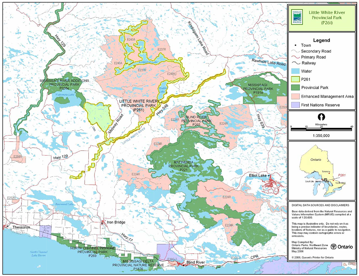
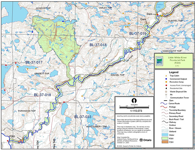
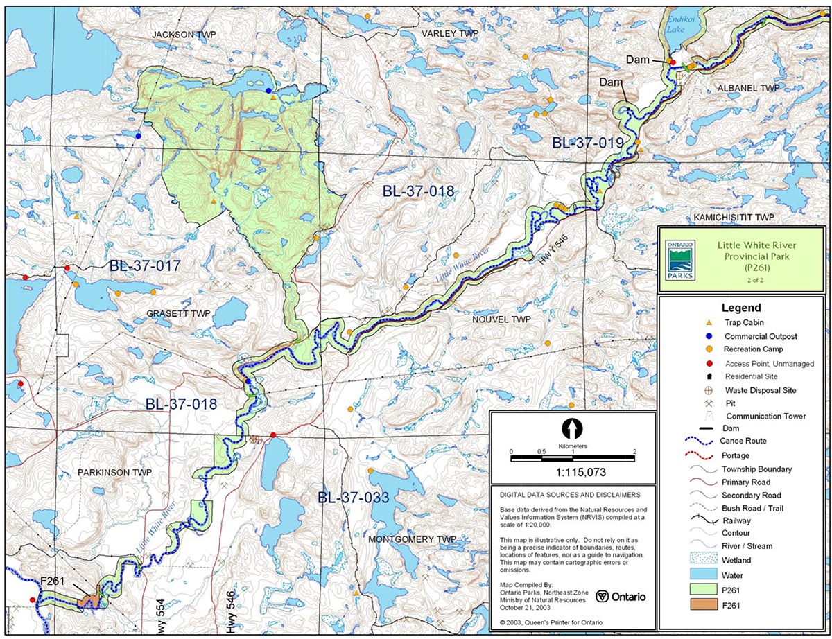
The upstream boundary of Little White River Provincial Park is located approximately 30 kilometres north of Elliot Lake (Figure 1). The park’s 12,782 hectares includes three broad units: a core area of the Little White River, the Blue Lakes headwater system and the Raven Lake Uplands (Figures 2a and 2b).
This waterway class park was identified through Ontario’s Living Legacy Land Use Strategy (OMNR 1999). Waterway parks protect outstanding recreational water routes and provide high quality recreational and educational opportunities. The park was regulated under the Provincial Parks Act in December 2002 (O. Reg. 311/02).
1.1 Objectives
Little White River Provincial Park will be managed according to provincial park objectives:
Protection: To protect provincially significant elements of the natural and cultural landscapes of Ontario.
Recreation: To provide Provincial Park outdoor recreation opportunities ranging from high-intensity day-use to low-intensity wilderness experiences.
Heritage Appreciation: To provide opportunities for exploration and appreciation of the outdoor natural and cultural heritage of Ontario.
Tourism: To provide Ontario’s residents and out-of-province visitors with opportunities to discover and experience the distinctive regions of the Province.
2.0 Management context
The purpose of this Interim Management Statement (IMS) is to provide direction to ensure the custodial management of park resources. Future park planning may be undertaken as required to provide direction on significant decisions regarding resource stewardship, development, operations and permitted uses.
Park management will follow direction from:
- Provincial Parks Act (1990) and regulations
- Ontario Provincial Parks Planning and Management Policies (OMNR 1992)
- Crown Land Use Policy Atlas (OMNR 2004a)
- Ontario’s Living Legacy Land Use Strategy (OMNR 1999) and policy clarification amendments (OMNR 2000) and related direction
In addressing custodial management obligations to protect park values and ensure public health and safety, Ontario Parks will ensure that policy and Environmental Assessment Act (1990) requirements are implemented.
Figure 1: Regional Setting
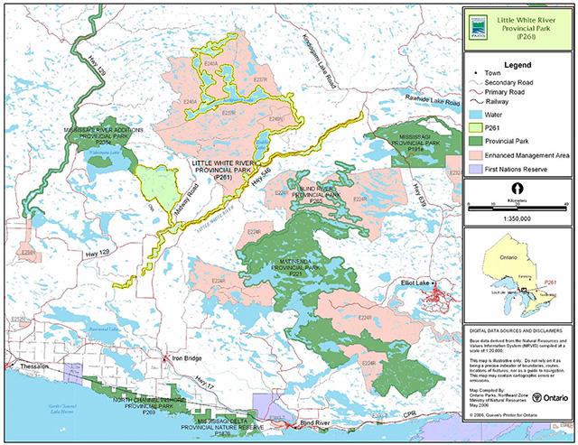
Enlarge Figure 1: Regional Setting map
Figure 2a: Park Boundary
Enlarge Figure 2a: Park Boundary map
Figure 2b: Park Boundary
Enlarge Figure 2b: Park Boundary map
2.1 Environmental assessment
As part of the Ontario Ministry of Natural Resources, Ontario Parks is a public sector agency that is subject to the Environmental Assessment Act. Park management will be carried out in accordance with legislation, policies and guidelines that are required under MNR's Class Environmental Assessment for Provincial Parks and Conservation Reserves (2005a).
3.0 Park features and values
The park includes approximately 100 kilometres of the Little White River from the Blue Lake headwater area (in Ecodistrict 4E-3) southwest to the Mississagi River (in Ecodistrict 5E-1). The river’s meanders, rapids, and gravel flats pass through forests and shoreline habitats such as wetlands, oxbow sloughs, and floodplain swamps of silver maple, black ash and white elm.
3.1 Geological features
Little White River Provincial Park is located almost entirely within the western part of the Paleoproterozoic Huronian Supergroup of the Southern Province). The waterway system of the Finn Lake area and the West Little White River, to the north end of Endikai Lake, flows through a small part of the south end of the western Abitibi Subprovince, in the Archean Superior Province of the Precambrian shield (Frey and Duba 2002).
The Huronian Supergroup consists of four stratigraphic groups of metasedimentary and minor metavolcanic and intrusive rocks that overlie the Superior Province. More than 90% of the bedrock in the park consists of Huronian Supergroup metasedimentary rocks. Varieties of conglomerate, sandstone, and siltstone of the Lorrain and Gowganda formations of the Cobalt Group are the most abundant rocks in the park. The representation of Huronian Supergroup stratigraphy in the large area of Cobalt Group Lorrain Formation sandstones in the Raven Lake area is regionally significant (Frey and Duba).
The Abitibi Subprovince rocks of the park are batholithic granites and quartz monzonites, part of the Algoma Plutonic Domain of the Ramsey–Algoma granitoid complex (Frey and Duba).
The primary surficial deposit in the park is thin, sandy to bouldery ground moraine till, deposited by the south-southwestward advancing Superior lobe of the continental ice sheet. The Little White River valley is a regionally significant outwash spillway that may have drained glacial Lake Sultan (Frey and Duba).
Most of the park area was part of a large island in a succession of proglacial lakes that formed as the ice sheet receded to the north. An isolated remnant of the Rawhide Lake recessional moraine on the southwest side of White Bear Lake marks the position of a temporary halt in the ice recession. This representation of the Rawhide Lake moraine is provincially significant within the parks system (Frey and Duba).
3.2 Biological features
Little White River Provincial Park straddles Ecodistricts 4E-3 and 5E-1 and includes a diversity of aquatic and terrestrial environments. Core features include the Blue Lakes complex, which are headwaters of the upper Little White River, Endikai Lake, the lower Little White River, and the Raven Lake uplands. Shallow water marshes exist on the lakeshores and in small, isolated patches of the Little White River. Other open wetlands (cattail marsh, open fen) are generally represented as small, isolated units throughout the site (Morris 2002a).
The largest forest ecosite in the park consists of intolerant hardwoods. Shade intolerant hardwood dominated communities (trembling aspen, white birch, and occasional large-tooth aspen) are most abundant flanking the lower Little White River near Endikai Lake and points downstream (Morris 2002b).
Stands of white pine-red pine are another of the more common forest ecosites within the park. Most white pine-red pine stands (with Jack pine) occur in the Raven Lake area and are mature to old-growth stands. The third most common forest ecosite is sugar maple forest, which consists of sugar maple, yellow birch, red oak, and eastern hemlock (Morris 2002b).
The Blue Lakes complex, Endiaki Lake, and both branches of the Little White River are important recreational cold-water and cool-water fisheries (Morris 2002). Fish species of these waters include lake trout, speckled trout, and naturalized rainbow trout (Kershaw 2002).
3.3 Cultural setting
No investigation into the cultural features specific to Little White River Provincial Park has been completed at this time.
Any future planning will be within the context of a provincial framework, A Topical Organization of Ontario History (OMNR 1974). In addition, updates and discussions with First Nations, other agencies and stakeholders may be carried out to identify cultural heritage values and features within the park and their significance. This information may be used to develop management guidelines to conserve and protect representative archaeological and historical values and features, or to provide direction for further research.
3.4 Recreation
The Little White River is a documented canoe route and offers experiences for novice to advanced level paddlers. The route is approximately 80 kilometres in length, but can be extended down the Mississagi River. The scenery and wildlife along the river offer excellent opportunities for wildlife viewing and photography.
The park also offers a variety of angling opportunities. Lake trout, speckled trout, and rainbow trout are common species (Kershaw 2002).
Camping occurs in association with car accessible areas and canoeing access sites (Kershaw 2002).
Hunting, snowmobiling, cross-country skiing, and hiking are also popular recreation activities in the park (Kershaw 2002).
4.0 Aboriginal uses
Little White River Provincial Park is within the Robinson-Huron Treaty (1850) and about 40 kilometres north of the Mississauga Indian Reserve.
The Chiefs of Batchewana, Garden River, Mississauga, Serpent River and Thessalon First Nations, as well as the North Shore Tribal Council, have received information on the boundary refinement of Little White River Provincial Park (OMNR 2002).
First Nations have expressed interest in and have shared knowledge of the park and surrounding area. Aboriginal communities have used the area for hunting, trapping, fishing, gathering and travel. These uses may continue, subject to public safety, conservation and other considerations.
Any communications and cooperation between Aboriginal communities and the MNR for planning and operations purposes will be done without prejudice to any future discussions or negotiations between the government of Ontario and Aboriginal communities.
5.0 Stewardship policies
The removal, damage or defacing of Crown properties, natural objects, relics and artifacts is not permitted in provincial parks (Provincial Parks Act).
5.1 Terrestrial ecosystems
5.1.1 Vegetation
Harvesting
Commercial forest harvesting and renewal activities are not permitted within the park (OMNR 2004a).
The harvest of non-timber forest products such as club moss, Canada yew etc., will not be permitted within the park.
Existing authorized wild rice harvesting may continue. New operations will not be permitted.
There are no fuelwood cutting permits currently issued for the park. No new permits will be issued (OMNR 2000).
Non-native plants
Non-native plant species will not be deliberately introduced into the park. Where non-native plant species are already established, and threaten park values, a strategy may be developed to control the species (OMNR 1992).
Insects and disease
Insects and diseases may be managed where the park’s aesthetic, cultural or natural values are threatened (OMNR 1992).
Controls will follow guidelines established by the Ontario Ministry of the Environment (MOE) and MNR. Biological controls, in preference to chemicals, will be used whenever possible (OMNR 1992).
Fire
The park is located within MNR's Boreal Fire Management Zone. In accordance with existing provincial park policy and the Forest Fire Management Strategy for Ontario, forest fire protection will be carried out in Little White River Provincial Park as on surrounding lands (OMNR 2004b).
Whenever feasible, MNR's Forest Fire Management program will use techniques which minimize damage to the landscape such as limiting the use of heavy equipment or limiting the number of trees felled during response efforts (OMNR 2004b).
5.1.2 Wildlife Management
Little White River is located within Wildlife Management Unit (WMU) 37. Removal or harassment of non-game animals is not permitted in provincial parks (Provincial Parks Act).
Hunting
Sport hunting is permitted to continue within the boundary of Little White River Provincial Park. Considerations of safety and conservation with respect to hunting may be made through future management planning, which includes public consultation (OMNR 2000).
The Fish and Wildlife Conservation Act (1999) and the Migratory Birds Convention Act (1994) govern hunting within the park. The Ontario Hunting Regulations Summary contains regulations specific to this area. The harvest of bullfrogs or snapping turtles is illegal in provincial parks.
Bear management areas
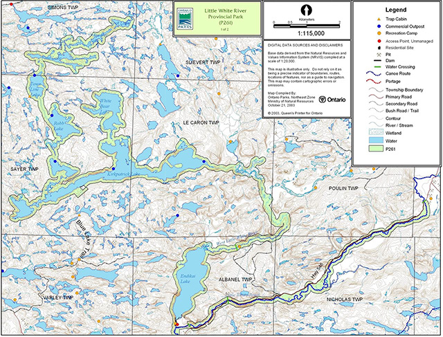
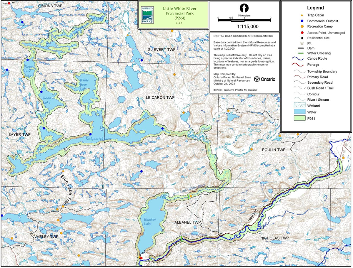
Little White River Provincial Park includes portions of six allocated bear management areas (BMA): BL-37-005, BL-37-012, BL-37-009, BL-37-019, BL-37-033, BL-37-018 (Figure 3).
Existing commercial bear hunting operations are permitted to continue. This activity may be subject to conditions identified during future management planning (e.g. the designation of nature reserve zones).
New BMA licences will not be permitted (OMNR 2000; 2003).
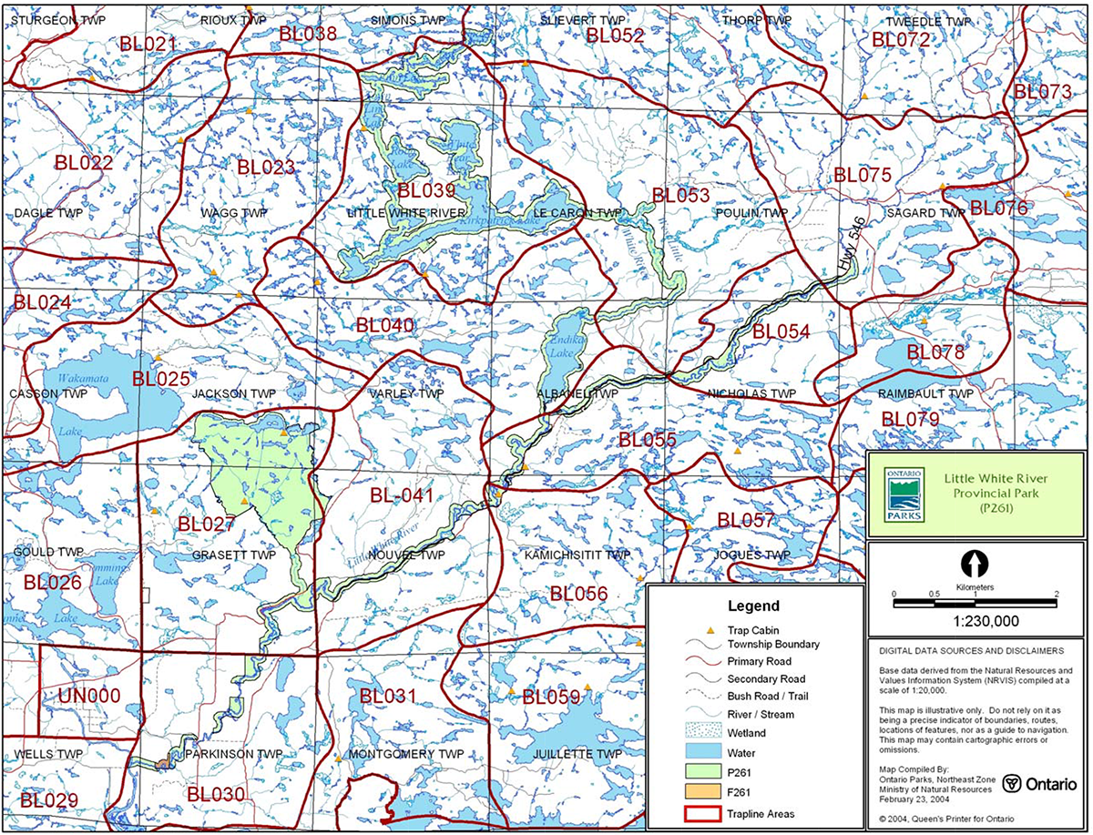
Trapping
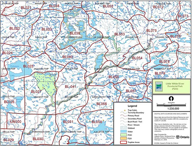
There are portions of eleven active trap lines within the boundary of this park: BLO75, BL054, BL052, BL039, BL053, BL040, BLO55, BLO56, BL041, BL027, BL030 (Figure 3). There are four trap cabins located within the park: BL027 contains 2 cabins; and BL039 and BL056 contain one cabin each.
Existing commercial fur harvesting operations may continue where the activity has been licensed or permitted since January 1, 1992. New operations, including trap cabins and trails, will not be permitted (OMNR 2000; 2003).
Transfers of active trap line licenses are permitted, subject to a review of potential impacts and the normal transfer or renewal conditions that apply.
5.1.3 Industrial resources
Aggregate extraction is not a permitted use within provincial parks (OMNR 1992; 2004a). However, there are two Ministry of Transportation (MTO) aggregate pits currently located within the park. These existing pits will be permitted to continue in the interim subject to conditions that may be identified in future planning.
There are no existing mining claims within park. The mining and surface rights on all lands within the park have been withdrawn from staking under the Mining Act (1990). Mineral exploration and mineral extraction are not permitted in provincial parks (OMNR 1992).
In accordance with Ontario’s Living Legacy Land Use Strategy, access in the park to mining lands (i.e. forest reserves and mining patents) will be permitted for purposes of mineral exploration, development or operations. Access will be planned in accordance with Environmental Assessment Act requirements.
A small forest reserve (F261) located adjacent to the park in Parkinson Township will be regulated as part of Little White River Provincial Park when the existing mining tenure is retired through normal processes.
5.1.4 Access and crossings
Access
Little White River Provincial Park is accessible via land, water and air.
The majority of the park is accessible via Highway 546, which parallels the park in Nouvel, Kamichisitit, Albanel, Nicholas, and Raimbault townships and crosses the river in three locations. Highway 554 also crosses the river in Parkinson Township. Several secondary and tertiary roads that branch from these highways provide access to other areas of the park.
Figure 3: Bear Management Areas
Figure 4: Trap Line Areas
The park is also accessible by snowmobile along the existing snowmobile trail that crosses the park in Parkinson Township.
The interior watercourse of the park is accessible by paddling the river and its tributaries.
Aircraft water landings are possible in the larger lakes within the park, such as Endikai, Town Line, Robb, White Bear, Kirkpatrick, and Skirl lakes.
Roads
Table 1 illustrates which roads have been identified for long term and secondary use by Northshore Forest Incorporated.
Table 1: Road Use
| Use level | Road Name | Township |
|---|---|---|
| Long term | Highway 5461 | Eight Twps |
| Long term | Poulin Strip (Ansley’s) Rd | Poulin |
| Long term | Nicholas Twp Rd | Nicholas |
| Long term | Scarbo Lk. Rd | Albanel |
| Long term | Endikai Strip Rd | Endikai |
| Long term | Cannon Mine Rd | Kamichisitit |
| Long term | Nouvel Rd | Nouvel |
| Long term | Scarbo Bridge Rd | Albanel |
| Long term | Big Lake Rd | Kamichisitit |
| Long term | Midway Rd | Grassett |
| Long term | Roy Berry | Grassett |
| Secondary | Parkinson Strip Rd | Parkinson |
| Secondary | Bells Falls Rd | Parkinson |
| Secondary | Reception Lake Rd | Grassett |
1Highway 546 is outside the park boundary but may require upgrading and realignment from time to time. This will be addressed through future planning.
The Little White River has four existing bridge crossings: Sagard (Hwy. 546), Albanel (Hwy. 546 and a secondary road), and Parkinson (Hwy. 554) townships. As per direction from the Ontario Forest Accord, one new road crossing of the park for forestry purposes may be permitted where alternatives that do not cross the park are determined to be unacceptable through future forest management planning.
The crossing of waterway parks by new roads may be necessary. The number of crossings will be minimized where possible and they will be managed to reduce their impact on recreational and aesthetic values. Any future road crossings proposed through the park, where park lands are unavoidable, will be reviewed on a case-by-case basis. Protection of park values will be priority. Any proposed development or maintenance/upgrading of existing roads must meet all Environmental Assessment Act requirements.
Where existing forest access roads are essential for continued access beyond the park for forest management or recreation purposes, and alternative road access does not exist, or road relocation is not feasible, existing roads will continue to be available for access. Continued use will include maintenance and may include upgrading (OMNR 2004a). Ontario Parks is not responsible for maintenance or upgrading of any existing roads within the park boundary.
Aggregate resource extraction is not a permitted use within provincial parks. An external source of aggregate is required for road improvements and maintenance.
Utility corridors
The boundary of Little White River Provincial Park is crossed at three locations by hydro corridors. These crossings occur in Jackson, Grasett, and Parkinson townships. These hydro corridors are managed through a province-wide land use permit.
Maintenance of these existing corridors will be permitted. These activities must adhere to the regulations set out under the relevant acts, such as the Environmental Assessment Act, the Canadian Environmental Protection Act (1999) and the Pesticides Act (1990). Maintenance activities shall not impact negatively on the values being protected within this park.
All public utilities (e.g. gas pipelines, transmission lines, communications towers, etc.) must avoid park lands wherever possible, however new utility corridor crossings may be necessary to maintain essential public services (OMNR 2004).
Any future utility corridors proposed through the park, where park lands are unavoidable, will be reviewed on a case-by-case basis. Protection of park features and values will be priority and all requirements of the Environmental Assessment Act will be met.
Recreational trails
Snowmobile Trails: There is one crossing of Little White River Provincial Park by an existing snowmobile trail. The Ontario Federation of Snowmobile Trails (OFSC) Trans Ontario Provincial Series (TOPS) feeder trail (D134) crosses through the park and over the Little White River near Bellingham in Parkinson Township.
Canoe Routes: The Little White River canoe route is approximately 80 kilometres in length and is rated as novice to advanced (OMNR). The route begins 68 kilometres north of Iron Bridge at the junction of Highway 546 and Highway 639 (OMNR). The route travels down the Little White River to where it joins with the Mississagi River. This route offers fishing and nature photography opportunities.
New trails (e.g. hiking) may be developed if the need arises. Any proposed development within the park is subject to Environmental Assessment Act requirements.
5.1.5 Adjacent land management
Forestry
The lands adjacent to this park are situated in the Northshore Forest management unit (#680). The North Shore Forest is currently managed by Northshore Forest Incorporated.
Provincial Parks
Mississagi River Provincial Park Additions (P238): Additions to the Mississagi River can be presented in two categories:
- Natural heritage areas put forward for protection
- Areas added to enhance recreational uses and provide ecological boundaries for the park
The Mississagi River Provincial Park Additions add approximately 67,256 hectares to the existing park. The additions are located directly adjacent to Little White River Provincial Park along the eastern shore of Wakomata Lake.
Forest Reserves
Forest reserves (FR) are areas where protection of natural heritage and special landscapes is a priority, but some resource use can take place with appropriate conditions. Policies for FRs are similar to the policies for new conservation reserves, except that mining and related activities will be allowed in a forest reserve. Commercial forest harvest, new hydroelectric power development, and peat extraction will not be allowed, but most other resource and recreation uses will be permitted, provided they are consistent with the features and values being protected (OMNR 1999).
Little White River Forest Reserve (F261): This small FR is located in Parkinson Township, east of the Mississagi River and Little White River fork. This forest reserve is bisected by the hydro corridor in its northeast corner. This land is not included in the regulated area of the park. As described in the proposed strategy for FRs (OMNR 2005b), this FR designation will be removed from all mining lands at the site, and will be redesignated as a General Use Area or an Enhanced Management Area (as appropriate).
Enhanced Management Areas
Enhanced Management Areas (EMAs) are a land use category established through Ontario’s Living Legacy Land Use Strategy to provide more detailed land use direction in areas of special features or values. There are three EMAs located adjacent to Little White River Provincial Park.
Kirkpatrick (Blue) Lake Area (E237r): This recreation EMA contains a number of high-quality cold water lakes which are managed through access restrictions and extended closed seasons. Traditional uses include snowmobiling, sport fishing, hunting, baitfishing and trapping.
Kirkpatrick Lake (E240a): This remote access EMA is adjacent to the park, and is located within the vicinity of a number of high quality cold water lakes which are managed through access restrictions and extended closed seasons (E237r).
Endikai Lake Perched Delta (E249n): This natural heritage EMA is an area of earth science significance in Ecodistrict 4E-3. It contains an ancient delta that was deposited at a point where the receding glacier was in contact with glacial Lake Algonquin. The site is in the headwater area of the Little White River.
General use areas
There are five general use areas adjacent to Little White River Provincial Park. These are outlined below:
Agricultural Lands (G1892): This is a 37,780 hectare General Use Area located at the southern boundary of the park. The stony nature of much of this area, coupled with the historically small size of pasture lands, has resulted in a complex pattern of active and abandoned farmland separated by forest, rock outcrops and other land types having low agricultural capability.
Winter Deer Habitat (G1893): This a 33,249 hectare General Use Area located adjacent to Little White River Provincial Park and the Agricultural Lands (G1892) General Use Area. Scattered throughout this area are numerous sites of varying size which offer deer shelter, food sources and open areas for travel, grazing and sunning.
Flack Lake Area (G1884): This 6,027 hectare General Use Area along the northeast boundary of the park is comprised of a complex of lakes and rivers in Raimbault and Nicholas townships. The intent is to manage this area for extensive recreation such as angling, canoeing, hiking and camping.
Aggregate Sites (G1879): This 3,874 hectare General Use Area is located to the northeast of the park and contains significant deposits of high quality aggregate in close proximity to demand centres. The intent is to protect critical aggregate deposits and allow for extraction.
Multiple Use Area (G1890): This 406,824 hectare General Use Area surrounds most of the central portions of Little White River Provincial Park. This area comprises a significant percentage of the land base from Thessalon to Serpent River, and northward along the Mississagi and Aubinadong rivers. The intent is to manage the area primarily for forestry, together with Crown land recreation and commercial/private recreation.
5.1.6 Land disposition
The park is located within the geographic Township of Kamichisitit, now in the Town of Blind River, and in the geographic townships of Simons, Sayer, LeCaron, Poulin, Sagard, Jackson, Varley, Albanel, Nicholas, Grasett, Nouvel, Wells and Parkinson, in the Territorial District of Algoma.
No new land disposition for private use or corporations will be permitted within the park boundaries (OMNR 2004a).
Land Use Permits, Licenses of Occupation, Unauthorized Occupations
There are twelve existing authorized private land use permits (LUPs) located within Little White River Provincial Park. These authorized uses are permitted to continue (OMNR 2000; 2004a). Table 2 describes the LUPs within the park:
Table 2: Land Use Permits
| Township | Use |
|---|---|
| Albanel |
|
| Nouvel |
|
Existing authorized LUPs for recreation camps may be eligible for enhanced tenure but not the purchase of land. Recreational camp LUPs cannot be changed to commercial land use permits unless this is supported during a review as part of park management planning. Enhanced tenure, is defined as a possible extension of the term of the land use permit for recreation camps up to 10 years or upgrade in tenure (i.e. land use permit to lease) (OMNR 2000).
Enhanced tenure for an LUP for a recreation camp is not guaranteed. Requests for enhanced tenure, or to transfer recreation camps, will be reviewed based upon the following criteria:
- Continued compliance with the conditions of the land use permit for recreation camps
- Current land disposition policies for LUPs
- Consistency with park objectives to sustain values – no effects on heritage values and/or conflict with other uses
- Consistency with Aboriginal land claim negotiations or protocol agreements
- All rents, taxes, fees, rates or charges are paid and in good standing
An extension in the term of tenure for an existing private recreation camp LUP does not convey a commitment to provide for a change in the type or the standard of existing access to the private recreation camp.
An existing private recreation camp LUP holder can relinquish their LUP and are responsible for having existing improvements removed including, but not limited to, the sale of any existing improvements. MNR may consider purchase of improvements.
There are nine existing commercial LUPs within the park (Section 6.3). Existing authorized facilities/operations are permitted to continue, but are subject to management prescriptions determined through park management planning (OMNR 2004a).
There are no known licenses of occupation within Little White River Provincial Park
There is one known unauthorized occupation in LeCaron Township.
Patent land
There are several parcels of private land that are surrounded by Little White River Provincial Park). These parcels of patent land are not included in the park and as such provincial park policies and legislation do not apply to these lands.
Boat caches
There are no authorized boat caches within the park.
As stated in the Provincial Parks Act, watercraft are not permitted to be left unattended without written permission from the park superintendent.
5.2 Aquatic ecosystems
Sustaining quality water resources is integral to the protection of park and adjacent lands values. The MOE enforces applicable legislation and regulations for water quality.
5.2.1 Water management
There are no existing water control structures or hydroelectric developments within the park. In the past, a dam at the outlet of Endikai Lake was managed by MNR. This dam has since failed and has not been replaced.
New water control and hydroelectric developments are not permitted within Little White River Provincial Park (OMNR 1992; 1999; 2004a).
5.2.2 Fisheries management
The Blue Lakes area in the park includes self-sustaining populations of lake trout, brook trout and rainbow trout. Fisheries management will complement the maintenance and enhancement of native, self-sustaining fish populations (OMNR 1992).
Sport fishing
Sport fishing is permitted within the park. This activity is governed by legislation and regulations in the Fish and Wildlife Conservation Act and the Fisheries Act (1985). The Recreational Fishing Regulations Summary contains details on the regulations that are applicable to this area.
Commercial baitfish harvesting
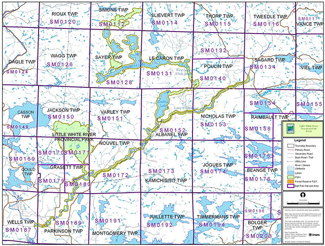
Simmons (SM0112), Sayer (SM0128), Poulin (south half, SM0140), and Grasett (north half, SM0171 and SM0170) townships are currently allocated for commercial baitfish harvesting (Figure 5).
Existing commercial baitfish harvesting may continue where the activity has been licensed or permitted since January 1, 1992. This activity may be subject to conditions identified through future park management planning or fisheries management plans. New baitfish licenses will not be permitted (OMNR 2000; 2003).
Commercial fishing
There are no commercial fishing operations within the boundary of Little White River Provincial Park. New operations will not be permitted (OMNR 2004a).
Fish stocking
The stocking of native fish species may be considered through park management planning, with full public consultation. Non-native fish species will not be deliberately introduced into park waters (OMNR 1992).
6.0 Operations policies
6.1 Recreation management
Future planning, with public consultation, will review direction on motorized and non-motorized recreation uses.
6.1.1 Motorized recreation
Motorboats
The use of motorboats is permitted to continue, unless park values are being threatened (OMNR 2004a).
Snowmobiles
The use of existing snowmobile trails is permitted to continue, unless park values are being threatened (OMNR 2004a).
Proposals for new trails may only be considered through future planning with public consultation (OMNR 2000).
Off-trail snowmobile use is not permitted within the park.
All-terrain vehicles
There are no authorized all-terrain vehicle (ATV) trails located within the park.
The use of ATVs on established trails for access to private land in-holdings and LUP areas is permitted to continue in the interim. Proposals for new trails may only be considered through future planning with public consultation (OMNR 2000).
Off-road use of ATVs will not be permitted within park boundaries unless authorized by the superintendent under the authority of the Provincial Parks Act.
Aircraft
Aircraft landings are permitted in the park (OMNR 2004a) but are subject to authorization by a valid aircraft landing permit issued by the park superintendent.
Figure 5: Commercial Baitfish Harvesting
6.1.2 Non-motorized recreation
Camping
There are several backcountry campsites within the park associated with paddling.
Ontario Parks may assess the condition of existing campsites and will maintain, rehabilitate or close sites as required. If there is an identified need, new backcountry campsites may be considered (OMNR 2004a). Infrastructure will be permitted in order to protect park features and values in response to use, environmental deterioration and environmental protection requirements. Any proposed development in the park must fulfill the requirements of the Environmental Assessment Act.
Hiking
Existing hiking trails may be permitted to continue unless such trails threaten park features and values, create user conflicts or raise safety/liability issues.
If there is an identified need, the development of new hiking trails may be considered. Trail infrastructure to protect park values and features will be permitted. Any proposed development within the park is subject to Environmental Assessment Act requirements.
Canoeing/kayaking
Existing uses may continue, unless park values are threatened (OMNR 2004a). Infrastructure to protect park features and values may be permitted and developed in response to use, environmental deterioration and environmental protection requirements.
6.1.3 Emerging recreational uses
There are emerging recreational uses for which there is limited or no policy to deal with their management (e.g. adventure racing, geocaching). The park superintendent will use legislation, policy and guidelines that are in place in the interim to manage emerging uses.
6.2 Development
There is no existing park infrastructure at this time. Infrastructure to protect park features and values may be permitted and developed in response to use, environmental deterioration and environmental protection requirements. Any proposed development within the park is subject to MNR's requirements under the Environmental Assessment Act.
6.3 Commercial tourism
There are nine commercial LUPs in the park. These permits are located in Albanel, Simon, Sayer, LeCaron, Jackson (2), Grasett (2), and Parkinson townships.
New commercial tourism facilities may be considered where consistent with park policy (OMNR 2004). Any development must meet the requirements of the Environmental Assessment Act.
7.0 Cultural resources
No assessment of the park’s cultural resources has been completed at this time, however management of any cultural features and values within the park will be directed toward protection and heritage appreciation (OMNR 1992).
8.0 Heritage education
Literature and other supporting information may be developed to describe the park in the context of Ontario’s provincial park system. Boundary limits, significant heritage features and permitted uses of the waterway park may be included in park literature.
Prospective park visitors may be informed about the sensitivity and significance of park values through park literature.
9.0 Research
Scientific research by qualified individuals which contributes to the knowledge of natural or cultural history, or to environmental or recreational management, may be encouraged in the park. Ontario Parks will encourage institutions, such as universities, to undertake research projects.
All research programs will require the approval of Ontario Parks and are subject to park policy and other applicable legislation. Any materials removed from the park will remain the property of Ontario Parks.
Approved research activities and facilities will be compatible with the park’s protection objective. Any site which is affected by research will be rehabilitated as closely as possible to its original state. Environmental Assessment Act requirements will apply.
10.0 References
Bergsma, B. 1998a. Area of Natural and Scientific Interest Life Science Checksheet – Little White River Palisades. Ontario Ministry of Natural Resources.
Bergsma, B. 1998b. Area of Natural and Scientific Interest Life Science Checksheet – Raven Lake White Pine. Ontario Ministry of Natural Resources.
Canadian Environmental Protection Act, 1999.
Environmental Assessment Act, 1990.
Fisheries Act, 1985.
Fish and Wildlife Conservation Act, 1999.
Frey, E. and D. Duba, 2002. Earth Science Checksheet – P261 Little White River Provincial Park. Ontario Ministry of Natural Resources.
Kershaw, W., 2002. Recreation Assessment – Little White River Provincial Park Inventory Report – Version 1.0. Ontario Ministry of Natural Resources.
Migratory Birds Convention Act, 1994.
Mining Act, 1990.
Morris, E.R., 2002a. Little White River Provincial Waterway Park Life Science Report. Draft. Ontario Ministry of Natural Resources.
Morris, E.R., 2002b. Natural Heritage Area Life Science Checksheet – Little White River Provincial Park (P261). Ontario Ministry of Natural Resources.
Ontario Ministry of Natural Resources. Date Unknown. Canoe Routes – Blind River District: Little White River Canoe Route.
Ontario Ministry of Natural Resources, 1974. A Topical Organization of Ontario History. Historic Sites Branch, Division of Parks.
Ontario Ministry of Natural Resources, 1992. Ontario Provincial Parks Planning and Management Policies.
Ontario Ministry of Natural Resources, 1999. Ontario’s Living Legacy Land Use Strategy. Ontario Ministry of Natural Resources, 2000. Ontario’s Living Legacy Land Use Strategy (Policy Clarification).
Ontario Ministry of Natural Resources, 2002. Public and Aboriginal Consultation Documentation Form Ontario’s Living Legacy Protected Area Boundary Refinement Review – Little White River Waterway Provincial Park.
Ontario Ministry of Natural Resources, 2003. Directions for Commercial Resource Use Activities in Provincial Parks and Conservation Reserves. 5 pp.
Ontario Ministry of Natural Resources, 2004a. Crown Land Use Policy Atlas.
Ontario Ministry of Natural Resources. 2004b. Forest Fire Management Strategy for Ontario. Aviation and Fire Management Branch.
Ontario Ministry of Natural Resources, 2005a. A Class Environmental Assessment for Provincial Parks and Conservation Reserves.
Ontario Ministry of Natural Resources, 2005b. Summary of Proposed "Disentanglement" Strategies for Recommended Protected Areas and Pre-existing Mining Lands.
Pesticides Act, 1990.
Provincial Parks Act, 1990.
Appendix A: Background information
| Name | Little White River Provincial Park (P261) |
|---|---|
| Classification | Waterway |
| Ecoregion/Ecodistrict | 4E-3 (Mississagi), 5E-1 (Thessalon) |
| OMNR Administrative Region/District | Northeast Zone, Sault Ste. Marie District |
| Total Area (ha) | 12,782 |
| Regulation date & Number | December 2002 (O. Reg. 311/02) |
Representation
Earth science:
Little White River Provincial Park is almost entirely within the western part of the Paleoproterozoic Huronian Supergroup of the Southern Province. The waterway system of the Finn Lake area and the West Little White River flows through a small part of the south end of the western Abitibi Subprovince, in the Archean Superior Province of the Precambrian shield.
The primary surficial deposit on the larger land areas of the park is thin, sandy to bouldery ground moraine till, deposited by the south-southwestward advancing Superior lobe of the continental ice sheet. The Little White River valley within the park is a major outwash spillway that may have been significant in the drainage of glacial Lake Sultan. Most of the park was part of a large island in a succession of proglacial lakes that formed as the ice sheet receded to the north. An isolated remnant of the Rawhide Lake recessional moraine on the southwest side of White Bear Lake marks the position of a temporary halt in the ice recession.
Life science:
Little White River Provincial Park straddles Ecodistricts 4E-3 and 5E-1 and includes a diversity of aquatic and terrestrial environments. The core features include the 'Blue Lakes' complex, which are headwaters of the upper Little White River, Endikai Lake, the lower Little White River, and the Raven Lake uplands.
The park includes portions of two life science areas identified in 1998:
The Raven Lake White Pine area was recommended as a provincially significant area for its representation of landform-vegetation ecosites (old growth white pine and forest dominated byred pine and jack pine on moderately broken bedrock uplands and complementary representation of moderately broken shallow sandy till uplands). This site is approximately four kilometres southeast of Wakomata Lake on the boundary between Jackson and Grasett townships.
The Little White River Palisades are located along the north shore of the river in Nouvel Township. The special features of this area are geological and botanical. The geological feature significance is the steep cliff face which likely provides habitat for rare plant species and possibly cliff dwelling birds. The sand terrace along the river also supports community types associated with dry sandy sites. The botanical features of known significance are the extensive pine forests with representations of jack, red, and white pine. This area is provincially significant.
The Blue Lakes complex, Endikai Lake, and both branches of the Little White River are important recreational cold-water and cool-water fisheries.
Cultural resources:
No investigation into cultural features specific to Little White River Provincial Park has been completed at this time.
Recreation and tourism:
The Little White River is a documented canoe route. The route is approximately 80 kilometres in length and is suitable for all levels of paddlers.
Fishing, hunting, snowmobiling, cross-country skiing, camping, and hiking are also popular activities within and around the park.
There are lodges (White River Lodge and Beaver Lodge) and commercial outposts located adjacent and within the park.
Inventories
| Survey Level | Earth Science | Life Science | Cultural | Recreational |
|---|---|---|---|---|
| Reconnaissance | Frey and Duba, 2002 | Morris, 2002 | Kershaw, 2002 |