Louck Lake Wetland Conservation Reserve Management Statement
This document provides policy direction for the protection, development and management of the Louck Lake Wetland Conservation Reserve and its resources.
Prepared with the assistance of:
Meteek & Company
Huntsville, Ontario
March 2004
Approval statement
We are pleased to approve this Statement of Conservation Interest for Louck Lake Wetland Conservation Reserve (C73).
Louck Lake Wetland Conservation Reserve consists of 265 hectares of Crown land, located about 3 kilometres north of the Village of South River, and immediately east of Highway 11. It is located in the unincorporated Laurier Township, in the Territorial District of Parry Sound. It is surrounded almost entirely by privately owned lands, which are not part of this conservation reserve.
This conservation reserve, located in ecological Site District 5E-8, contains much of the area of a provincially significant wetland (Louck Lake Wetland). It is an excellent example of the flat glacial deposits that snake north to south across the area west of Algonquin Provincial Park. The flat lands and organic deposits are on an ancient sand plain associated with glacial Lake Algonquin. This land type is very limited in the site district. Louck Lake is a shallow water body with extensive open water, and floating and submergent aquatic vegetation. The shorelines are dominated by low shrub marshes and shrub fens, ringed by lowland conifer swamps on peat.
Louck Lake Wetland Conservation Reserve is one of 378 new protected areas approved through Ontario’s Living Legacy Land Use Strategy, aimed, in part, at completing Ontario’s system of parks and protected areas.
During the “Lands for Life” planning process, the public was widely consulted and provided valuable input into what became Ontario’s Living Legacy Land Use Strategy. Comments received during that time, and during consultation related to the formal Public Lands Act regulation of the boundaries of this conservation reserve, were generally supportive of the protection of this area. Stakeholders who provided comment during the earlier consultation for this site were subsequently consulted regarding the draft Statement of Conservation Interest and their comments were considered in the finalization of this document.
This Statement of Conservation Interest provides guidance for the management of the conservation reserve and provides the basis for the ongoing monitoring of activities. More detailed direction is not anticipated at this time. Should more complex resource management or conservation issues arise or significant facility development be considered, then a detailed Resource Management Plan will be prepared with full public consultation.
Louck Lake Wetland Conservation Reserve is managed under the direction of the District Manager and the Bracebridge Area Supervisor of the Ministry of Natural Resources, Parry Sound District.
Approved by:
R. Griffiths
District Manager
Parry Sound District
Approved by:
Ron Running
Regional Director
Southern Region
1.0 Introduction
Ontario’s Living Legacy, the result of an extensive planning process that began in early 1997, culminated in the approval in July 1999 of a Land Use Strategy that identifies the intended strategic direction for Crown land, including the completion of Ontario’s system of parks and protected areas. This process, which included extensive public consultation, resulted in the recommendation for regulation of 378 new protected areas, including Louck Lake Wetland Conservation Reserve (C73).
Louck Lake Wetland Conservation Reserve consists of 265 hectares of Crown land, located about 3 kilometres north of the Village of South River. It lies in the unincorporated area of Laurier Township, in the Territorial District of Parry Sound. It is surrounded almost entirely by privately owned lands, which are not part of this conservation reserve.
Louck Lake Wetland Conservation Reserve is located in ecological Site District 5E-8, and includes most of a provincially significant wetland and some areas of upland mixed forest. It is an excellent example of the flat glacial deposits that snake north to south across the area west of Algonquin Provincial Park. The flat lands and organic deposits are on an ancient sand plain associated with glacial Lake Algonquin. This land type is very limited in the site district. Louck Lake is a shallow water body with extensive open water, and floating and submergent aquatic vegetation. The shorelines are dominated by low shrub marshes and shrub fens, ringed by lowland conifer swamps on peat. The site has within its boundaries one lake (Louck Lake), and four small, unnamed streams. The southeastern boundary is bordered by Bacon Lake, which is joined to Louck Lake by a small stream. Moose Lake is connected to Louck Lake by a small stream that lies partially within the conservation reserve. A Canadian National Railway line cuts across the eastern part of this site. Its right-of-way is not a part of the conservation reserve.
Conservation reserves are established under the authority of the Public Lands Act, Ontario Regulation 805/94. Louck Lake Wetland Conservation Reserve was established by Ontario Regulation 148/02 on May 8, 2002.
A Statement of Conservation Interest (SCI) is prepared under the direction of Procedural Guideline A – Resource Management Planning (PL. Procedure 3.03.05). The purpose of this SCI is to identify and describe the values of Louck Lake Wetland Conservation Reserve. The SCI also outlines the activities that currently occur within the conservation reserve and provides guidelines for the management of current and future activities in the context of protecting the natural, recreational and cultural values.
1.1 Background information:
- Name: Louck Lake Wetland Conservation Reserve (C73)
- Site Region/District: Georgian Bay 5E-8
- OMNR Administrative Region/District/Area: Southern Region/Parry Sound District/ Bracebridge Area
- Total Area (ha.): 265 hectares
- Regulation Date: May 8, 2002 (O. Reg. 148/02)
- First Nations: Robinson-Huron Treaty and Williams Treaty
- OBM map sheets: 10 17 6250 50800
- Topographic Map: South River 31 E/14
- UTM co-ordinates: 17T 62710 508200 (Centroid)
1.2 Representation
Earth science representation
Bedrock
The dominant rock type, which is visible only as small flat-lying shoreline outcrops, is migmatitic felsic gneiss derived from the possibly metasedimentary protolith of the Powassan Domain, Algonquin Terrain, in the central part of the Central Gneiss Belt of the Proterozoic Grenville Province.
Surficial
Organic deposits over a sand plain of glacial Lake Algonquin.
Life science representation
The conservation reserve includes a large part of a provincially significant wetland that offers swamp, marsh, permanent shallow open-water marsh, and poor fen habitat, along with some areas of upland mixedwood forest.
Cultural resources representation
Neither detailed cultural research nor inventory has been carried out of r this conservation reserve. Recent regional evaluation (OMNR, 2003) shows that this conservation reserve contains areas that have a high potential for cultural heritage sites.
Recreational opportunities
A recreational inventory report was prepared for this site based on existing knowledge and data sources of MNR staff, and site visits (Gavel, 2003). Currently, it is used for moose and waterfowl hunting, and some limited angling. Public access to the site is limited.
1.3 Survey work
| Survey Level | Earth Science | Life Science | Cultural | Recreational | Other |
|---|---|---|---|---|---|
| Reconnaissance | Duba & Frey, 2001 | Burns, 2002 Kamstra, 1994 | OMNR, 2003 | Gavel, 2003 | None |
| Detailed | None | None | None | None | None |
| Requirement | None | Monitor the status/presence of significant species and associations. | Research to be encouraged | Monitor use impacts | None |
2.0 Values to be protected
The conservation reserve is located entirely within Hills' (1959) ecological Site District 5E-8. Values include earth science, life science and recreational/aesthetic values, with an emphasis on the life sciences.
2.1 Earth Science:
(Earth science information, unless otherwise noted, is taken from Duba & Frey, 2001)
Bedrock
Louck Lake Wetland Conservation Reserve is a low relief area of wetlands, with limited exposures of bedrock as small, flat lying shoreline outcrops at the edge of wetlands and lake shorelines. The dominant rock types are migmatitic felsic gneisses, intruded by late granite pegmatite. The gneisses are interpreted to be derived from a clastic metasedimentary protolith of the Powassan Domain, Algonquin Terrane, in the Central Gneiss Belt of the Proterozoic Grenville Province.
The Grenville Province is the product of thrusting and imbrication of the crust to the northwest as it collided with a continental landmass to the southeast. The Grenville Orogeny, circa 1140 to 1070 million years ago, culminated more than 500 million years of crustal evolution. The eroded roots of the products of these events are displayed in the complexly metamorphosed and deformed rocks of the region (Easton, 1992b, p.1302).
The Algonquin Terrane is one of four lithotectonic terranes of the Central Gneiss Belt. Within the Algonquin Terrane, the Powassan Domain is one of twelve structural domains. This geological environment is part of the modern organization of the complex products of the mid-Proterozoic Grenville orogenic events (Easton, 1992a and b). As such, its representation in Louck Lake Wetland Conservation Reserve contributes to the conservation of the Grenville continental accretion theme outlined by Davidson (1981, p.107-111).
The migmatitic felsic gneiss is a typical representation of a probable metasedimentary supracrustal component of the Powassan Domain, Algonquin Terrane. Within the Ontario Provincial Park system, the bedrock geological features observed in Louck Lake Wetland Conservation Reserve have local to regional significance.
Surficial
Louck Lake Wetland Conservation Reserve lies in a low relief terrain underlain by thick complexes of ice contact and glaciolacustrine sediments. Within the conservation reserve, recent organic and bog deposits occupy the wetlands, which overlay sediments. The glaciolacustrine sediments are visible as small patches adjacent to Louck Lake.
The glaciolacustrine and organic deposits are typical components of the Quaternary Era in southern Ontario, and are locally significant.
2.2 Life Science:
(Life science information, unless otherwise noted, is taken from Burns, 2002)
The conservation reserve is located within Hills' (1959) ecological Site District 5E-8. Life science significance is determined on the basis of the following criteria: representation, diversity, condition, ecological considerations and special features (Crins and Kor, 1998).
Representation
The conservation reserve includes most of a provincially significant wetland and some areas of upland mixed forest situated on Crown land. It is surrounded almost entirely by private land, which is not part of the conservation reserve. It was selected for protection during the development of Ontario’s Living Legacy because it is a recognized provincially significant wetland that offers permanent shallow open water marsh habitat located on Crown Land.
Louck Lake Wetland Conservation Reserve is within ecological Site District 5E-8, which is characterized by moderately rolling bedrock on the Precambrian Shield covered by a thin layer of stony sandy till with some areas of glaciofluvial sand and gravel deposits. Large valley flats of sand, silts and clay are not uncommon in this region. This site is on a landform that is very limited in this Site District (IVc-3: weakly broken lacustrine sand plain (organic)); it is also includes part of landform IVd-1 (weakly broken lacustrine deltaic sand plain). It has flat lands and organic deposits that are associated with glacial Lake Algonquin. Its climatic conditions are typified by less precipitation and cooler temperatures, which results in a shorter growing season (Noble, 1983).
The conservation reserve is comprised of approximately 30% upland and 70% wetland sites including swamp, marsh, open water marsh, and poor fen communities. The upland sites within this conservation reserve have uneven ground with large rocks and boulders and a mixed forest containing white birch, poplar, red maple, white pine, balsam fir and spruce trees.
The Louck Lake Wetland was evaluated in 1993 using the Ontario Wetland Evaluation System: Northern Manual (1993). Three of the four wetland types are represented in the conservation reserve: swamp, marsh and fen.
A swamp is an area associated with streams, rivers or lakes that has water flowing through it. The presence of trees and shrubs distinguishes swamps from marshes. Conifer swamp communities predominate in the Louck Lake Wetland. These are dominated by tamarack (Larix laricina) and, black spruce (Picea mariana) with an understorey of various tall shrubs including northern wild raisin (Viburnum cassinoides) and speckled alder (Alnus rugosa), low shrubs including sweet gale (Myrica gale), leatherleaf (Chamaedaphne calyculata) and Labrador tea (Ledum groenlandicum) and abundant herb and moss layers.
A marsh is an area associated with frequently or continuously flooded wetlands with shallow water (<1m in depth). Marshes are characterized by abundant emergent herbaceous vegetation. The marsh areas of Louck Lake Wetland Conservation Reserve are characterized by sweet gale (Myrica gale), leather leaf (Chamaedaphne calyculata), St. John’s wort (Hypericum virginicum), aster (Aster nemoralis), three-way sedge (Dulichium arundinaceum), cattails (Typha sp.), mint, sedges (Carex sp.), and bur reed (Sparganium sp.). Open water marsh communities are also prevalent at Louck Lake; the main part of the lake is dominated by open water marsh. They include various floating and submerged plants such as water lily (Nuphar variegatum), water shield (Brasenia schreberi), bladderwort (Utricularia sp.), and pondweeds (Potomogeton sp.). The abundance of marshes at this wetland provides excellent breeding and staging habitat for waterfowl and shorebirds.
Poor fens, like bogs, have peat accumulation and occur in drainage restricted situations which result in vegetation adapted to grow in these harsher conditions. The poor fen communities at Louck Lake are located mainly off the south end of the lake and are characterized by stunted tree growth of tamarack and black spruce, a thick Sphagnum sp. moss layer over a thick layer of peat, and various ericaceous shrubs along with herbs and sedges (Carex sp.) typical of this wetland type.
According to the wetland evaluation (McDonnell, 1993) and a visit by MNR staff in September 2002, the habitat surrounding the wetland consists of deciduous forest and planted coniferous forest. Some common tree species found in the upland area of the site include white birch (Betula papyrifera), red maple (Acer rubrum), poplar (Populus sp.), white pine (Pinus strobus), balsam fir (Abies balsamea) and spruce (Picea sp.). Some of the more common herbaceous plants found were bracken fern (Pteridium aquilinum), bunchberry (Cornus canadensis), trillium (Trillium grandiflorum), dog-tooth violet (Erythronium americanum), and various mosses.
Condition
Louck Lake Wetland Conservation Reserve is relatively undisturbed because a large portion of the site is wetland. There are no public access roads into the site. The recent twinning of Hwy 11 has brought the eastern edge of the new highway in contact with the western edge of the wetland. The Canadian National Railway has a railroad line that cuts through the southeastern portion of the conservation reserve. In the 1950s and 1960s, District Cutting Licences were issued on a yearly basis. During this time poplar, balsam fir, and spruce were extracted for saw logs, pulp and fuelwood. There is no record of cutting after 1968.
There is one private road into Louck Lake Wetland Conservation Reserve. Recent construction activity on Highway 11 has resulted in some changes to this road. This road is privately owned and the landowner must be contacted for permission to use it.
There is no evidence of hiking trails or campsites within the conservation reserve.
Diversity
Although the terrain within this conservation reserve is diverse, the acidic, nutrient-poor soil conditions limit the botanical diversity of this site. With the exception of one provincially significant species, New England sedge (Carex novae angliae), the botanical species are unremarkable (Kamstra, 1994). Faunal diversity is also unremarkable.
Ecological considerations
The conservation reserve forms part of the upper headwaters of Louck Lake. The deep deposits of glacial till covered by mature forest provide an essential groundwater recharge area for the surrounding watercourses. The valley of Louck Lake and to a lesser extent Beaver Meadow Creek are wide, flat and relatively undisturbed by human activity or structures. As such, they form an important wildlife corridor linking French River, Restoule Lake and Lake Nipissing to the north with the relatively remote and undisturbed landscapes of Lount and Ferrie Townships.
Special features
There is an active osprey nest within the reserve and two plants that are classified as Locally Rare Vascular Plants for Site District 5E-8.
2.3 Cultural values:
No specific cultural studies or inventories have been undertaken within the conservation reserve, and no major cultural resource values have been evaluated or identified to date.
Recent regional evaluation (OMNR, 2003) shows that this conservation reserve contains areas that have a high potential for cultural heritage sites.
2.4 Recreational/aesthetic values:
The area was used for hunting waterfowl in the past as is evidenced by the presence of duck blinds. However, the duck blinds do not appear to have been used for a long time. It is unclear whether any waterfowl hunting currently takes place.
The lack of public access and a lack of sport fish results in limited fishing opportunities, although adjacent Bacon Lake receives some local angling. There is no evidence of hiking trails or campsites within the conservation reserve.
The distance of this conservation reserve from urban areas has resulted in a relatively pristine night sky, which enhances the sense of remoteness and wilderness of this site. Pristine night skies are considered a significant value, given the increasingly limited areas of southern and central Ontario which are not heavily affected by light pollution.
3.0 Management guidelines
3.1 Land tenure:
Background
Louck Lake Wetland Conservation Reserve comprises 265 hectares of Crown land, located about 3 kilometres north of the Village of South River, and immediately east of Highway 11. It is located in the unincorporated Laurier Township, in the Territorial District of Parry Sound. It is surrounded almost entirely by privately owned lands, which are not part of this conservation reserve. The Canadian National Railway has active railroad tracks that intersect the southeastern portion of the conservation reserve. The railway owns a 23 metre right-of-way on either side of the tracks and that area is excluded from the conservation reserve.
The conservation reserve includes the shore road allowances on the western shoreline of Bacon Lake, and around the southern and central western parts of Louck Lake, as well as a short stretch of road allowance in Lot 5, between Concessions 7 and 8. It is MNR’s intent to stop up and close these areas of road allowance.
The conservation reserve lies within Bear Management Area BR-48-19. It also occupies a portion of Bait Fish Block PS0058. There is one registered trapline (BR-36) that extends into the conservation reserve. There are no authorized recreation camps within the boundaries of the conservation reserve.
Guideline
The sale of Crown lands within the conservation reserve is generally not permitted.
There are no plans by the MNR to acquire private lands to add to the conservation reserve. However, MNR may consider donations of private lands within the provincially significant wetlands as additions to the Conservation Reserve.
The commercial bear hunting service associated with the current Bear Management Area is allowed to continue. Fur harvest is permitted to continue in the registered trapline area. The Bait Fish Block is permitted to continue.
New recreation camps are not permitted in this conservation reserve.
3.2 Development:
Background
There are no Crown-owned buildings or other facilities within the conservation reserve. There is one road crossing through Lot 4, Concession 7 in the conservation reserve, providing access from private land at Lot 4, Concession 8, to the west side of Louck Lake.
Guideline
New roads for resource extraction and/or private use will not be permitted, nor will additions to existing roads, or up-grading of existing roads be permitted. There is no intention to develop roads outside of the conservation reserve to improve access to this site.
New recreational trails may be considered on a case by case basis provided that they meet Procedural Guideline B – Land Uses – Test of Compatibility (see Appendix 1) and the MNR’s Environmental Assessment Act requirements. Public consultation will generally be required during the consideration of changes to existing trails, and will always be required for new trails. New recreational trails will not be permitted in or within 120 metres of the provincially significant wetland unless it has been demonstrated that there will be no negative impacts on the natural features or the ecological functions of the wetland.
New recreational trails for motorized vehicles will not be permitted, unless the following have been demonstrated:
- there is a community need for the trail, as well as community support;
- there are no alternative suitable locations outside the conservation reserve;
- the trail location would be acceptable and suitable for four-season use;
- the trail would meet the requirements applicable to all trails, as identified in the preceding paragraph.
Unauthorized works within the conservation reserve will be handled in accordance with the Public Lands Act, and any required removal of improvements will be at the expense of those responsible.
No mineral exploration is permitted within this conservation reserve. This policy direction is based on a commitment made by the Ministry of Natural Resources and the Ministry of Northern Development and Mines in March 2002. This direction replaces that identified in the 1999 Ontario’s Living Legacy Land Use Strategy (OMNR, 1999), which stated that controlled mineral exploration would be permitted in new conservation reserves which were identified as having provincially significant mineral potential.
Any new development must meet MNR’s commitments to protect cultural heritage values (see Section 3.7). While there is no intent at present to provide or permit any new development in this conservation reserve that would require lighting, should this be considered at some point in the future the MNR will not allow unnecessary, undirected light pollution. This commitment recognizes the wilderness values provided by a pristine night sky.
3.3 Recreational activities:
Background
There are reports that this area has been used for big game hunting, waterfowl hunting and angling. However, duck blinds do not show recent signs of use, and a 1993 post-stocking assessment of Bacon Lake did not produce game fish. This evidence, along with the lack of public access, suggests that the site is no longer used significantly for hunting and fishing.
There is little evidence of the use of the conservation reserve by hikers, birdwatchers, canoeists (for other than fishing), mountain bikers, skiers, or snowshoers.
Guideline
Hunting and fishing are permitted to continue within the conservation reserve.
Recreational use such as hiking, wildlife viewing, canoeing, snowshoeing, and cross-country skiing, while currently very limited in extent and therefore not managed, are allowed to occur in the conservation reserve.
Recreational use of this site, including any increase in use of all-terrain vehicles, will be monitored to ensure that the conservation reserve values are not being adversely impacted.
As discussed above, (Section 3.2 Development) new recreational trails may be considered on a case by case basis provided that they meet Procedural Guideline B – Land Uses – Test of Compatibility (see Appendix 1) and the MNR’s Environmental Assessment Act requirements. Public consultation will generally be required during the consideration of changes to existing trails, and will always be required for new trails. New recreational trails will not be permitted in or within 120 metres of the provincially significant wetland unless it has been demonstrated that there will be no negative impacts on the natural features or the ecological functions of the wetland. Any new trails must meet MNR’s commitments to protect cultural heritage values (see Section 3.7).
New recreational trails for motorized vehicles will not be permitted, unless the following have been demonstrated:
- there is a community need for the trail, as well as community support;
- there are no alternative suitable locations outside the conservation reserve;
- the trail location would be acceptable and suitable for four-season use;
- the trail would meet the requirements applicable to all trails, as identified in the preceding paragraph;
Off-trail use of snowmobiles and all-terrain vehicles is only permitted for the direct retrieval of game.
New recreational activities will be considered on a case by case basis provided they are consistent with maintaining the values of the conservation reserve and comply with Procedural Guideline B – Land Uses – Test of Compatibility (Appendix 1) and the MNR’s Environmental Assessment Act requirements. Emphasis will be placed on activities that have a low impact on the environment of the conservation reserve.
Monitoring of existing and permitted activities will be undertaken as required to ensure that the conservation reserve values are not being adversely impacted.
3.4 Commercial activities:
Background
There has been no recent commercial forest harvesting or mining activity within the conservation reserve.
There is currently one registered trapline covering this conservation reserve. The guiding of non-resident bear hunters is authorized through a Bear Management Area and bait fish harvesting is authorized through a Bait Fish Block licence, which covers the site. These activities were discussed in Section 3.1 Land Tenure- Background.
Guideline
Fur harvesting, bear hunting services and bait fish harvesting operations are allowed to continue within the conservation reserve. New trapline cabins are not permitted within conservation reserves.
Mineral exploration is not allowed in this conservation reserve, as discussed in Section 3.2.
Conservation reserve regulations do not permit mining, commercial forest harvesting, hydroelectric power development, the extraction of aggregate and peat or other industrial uses (Public Lands Act, Ontario Regulation 805/94). Other new commercial activities must meet the requirements of Procedural Guideline B – Land Uses – Test of Compatibility (see Appendix 1).
3.5 Aboriginal interests:
Background
This site is known to be of interest to many First Nation communities. There are 2 treaties associated with the area: the Robinson – Huron Treaty of 1850 and the Williams Treaty. A Supreme Court decision in 1994 (Howard) validated that the Williams Treaty surrendered hunting, fishing and trapping rights of those First Nations affiliated with that treaty.
Guideline
The regulation and management of this conservation reserve will not impede the exercise of existing aboriginal or treaty rights. These rights include hunting, fishing, fur harvesting, gathering of plants for a variety of purposes, and the use of ceremonial sites. It is recognized that the manner in which these rights are carried out is not limited to the manner in which they were carried out in the past, but has evolved over time with changes in technology.
While there are no existing First Nation land claims that extend to this site, it is recognized that at some point in the future there is a possibility of a land claim in this area. If such a land claim is determined to be valid, the conservation reserve designation is not irreversible and does not preclude consideration of these lands in the settlement of a claim. If deregulation of part or all of a conservation reserve occurs as part of the settlement of a claim, this will be carried out at no cost to First Nations.
3.6 Natural resource stewardship:
Background
Vegetation management for specific purposes (other than pre-1960s logging) is not known to have occurred in the past. Wildlife management and fisheries management have been occurring according to the prevailing policies and legislation.
The emphasis will be on ensuring that the natural values of the conservation reserve are not negatively affected by current and future activities. Therefore, applications for new specific uses will be carefully studied and reviewed. Necessary studies may be undertaken by proponents, the Ministry, and/or partner organizations.
Guideline – vegetation
The intent of this site is to allow the existing vegetation communities to evolve naturally.
The OMNR recognizes fire as an essential process fundamental to the ecological integrity of this conservation reserve. In accordance with existing conservation reserve policy and the Forest Management Strategy for Ontario, forest fire protection will endeavour to use “light on the land” techniques, which do not unduly disturb the landscape, in this conservation reserve. Examples of light on the land techniques may include limiting the use of heavy equipment, and limiting the number of trees felled during fire response efforts. Input from the local MNR Area Supervisor would be solicited if a forest fire threatens the area. Opportunities for prescribed burning to achieve resource management objectives may be considered. Plans for any prescribed burning will be developed in accordance with the OMNR Prescribed Burn Planning Manual.
Programs may be developed to control forest insects and diseases in the conservation reserve where these threaten significant values in or adjacent to the site. Where insects or disease threaten significant values, in or adjacent to the site, and MNR determines that control is warranted, control within the conservation reserve will be directed by the MNR as narrowly as possible to the specific insect or disease. Biological control will be used wherever possible. In all cases, regard shall be had for Procedural Guideline B – Land Uses – Test of Compatibility (see Appendix 1).
Guideline – wildlife and fisheries
The relevant Ontario hunting and fishing regulations will guide these activities within Louck Lake Wetland Conservation Reserve. Fur harvesting, bear harvesting and bait fish harvesting will be managed through the maintenance of the current licencing system.
The Ministry will monitor the impacts of increasing recreational activities, including snowmobile and all-terrain vehicle use on the natural values of the conservation reserve.
3.7 Cultural resource stewardship:
Background
No specific cultural studies or inventories have been undertaken within the conservation reserve, and no specific significant cultural resource values have been evaluated or identified to date. Recent regional evaluation (OMNR, 2003) shows that this conservation reserve contains areas that have a high potential for cultural heritage sites.
Guideline
Should the MNR consider either carrying out or permitting new structural development, significant clearing of vegetation or altering of land within this conservation reserve, the MNR will adhere to the cultural heritage resource screening process as is identified in its Memorandum of Understanding (MOU) with the Ministry of Culture. While the purpose of this MOU is to provide a process to identify and protect cultural heritage resources when the MNR is reviewing work permits or disposing of Crown rights under the authority of the Public Lands Act, the considerations and criteria would also en able the MNR to identify high potential cultural heritage areas for other purposes within conservation reserves. If the screening process indicates that the site of a proposed activity is within an area of high cultural heritage potential, the MNR will consult with the Ministry of Culture to determine the appropriate cultural heritage assessment requirements and will undertake a preliminary archaeological assessment if appropriate.
Interested partners will be encouraged to undertake inventories, studies, and research to document the histories of First Nations, settlement, resource harvest/management and recreation in the area. The MNR will discuss the appropriateness of any proposed archaeological assessment with local First Nations and the Ministry of Culture.
3.8 Client services:
Background
Access to the conservation reserve has generally been confined to traditional uses for the current commercial and recreational activities. There are no Crown facilities or services developed in or adjacent to the conservation reserve. The information fact sheet for this conservation reserve is currently available to the public through the Parry Sound District Office, Bracebridge Area Office or via the Internet at www.ontarioslivinglegacy.com [inactive link]. An additional fact sheet about the values of Louck Lake Wetland will be available at the MNR offices in Parry Sound and Bracebridge.
Guideline
The focus will remain on low key information and self-interpretation of conservation reserve values and features. Consideration will be given to the preparation of an information brochure (with map) to highlight the features for which the area was identified and appropriate uses to ensure the protection of those features.
Consideration will be given to the strategic location of identity signs where Highway 11 borders the west side of the conservation reserve, and where the road from Lot 4, Concession 8 crosses the conservation reserve boundary. There are no plans for structural development within this conservation reserve.
3.9 Research:
Background
Research to date has included a number of reconnaissance surveys to document earth science, life science and recreation values, and wetland evaluation using the Ontario Wetland Evaluation System: Northern Manual (1993).
Guideline
Research focusing on the assessment of use/activity impacts on wildlife species and habitats will be encouraged.
All research will be carried out in a non-destructive manner. Research proposals must follow Procedural Guideline C – Research Activities in Conservation Reserves (Appendix 3).
3.10 Marketing:
Background
There has been no marketing of this conservation reserve to date. Promotion and information about this site has been primarily through the Ontario’s Living Legacy planning process and recent MNR Parry Sound District public consultation regarding the boundaries of this site.
Guideline
Marketing activities of this conservation reserve will be kept to a minimum.
4.0 Implementation
Administrative responsibility for this conservation reserve belongs to the Bracebridge Area Office of the Parry Sound District of the Ministry of Natural Resources. The Area Office will continue to have the custodial care of Louck Lake Wetland Conservation Reserve. Emphasis will be placed on awareness information highlighting reserve values, and monitoring and managing the current approved uses.
Priorities will include:
- Ensure compliance to prescribed management direction of the approved SCI;
- Stop up and close the areas of road allowance described in Section 1 Land Tenure – Background;
- Monitor and evaluate existing and allowed recreational and commercial use levels and impacts as required to ensure that conservation reserve values are not being adversely impacted;
- Encourage further inventory and research of the significant life science resources of the conservation reserve;
- Support cooperative ongoing education of resource users with respect to resource and land stewardship values, in order to maintain the ecological integrity of the site and to provide long term recreational opportunities; and
- Provide client services (e.g. brochure or fact sheet) at nearby MNR offices.
5.0 Review and revision of the Statement of Conservation Interest
This Statement of Conservation Interest will be amended through a standard process of minor and major amendments. Minor amendments will be processed in a relatively informal manner and will require the approval of the Area Supervisor. These amendments will deal with uses and activities that do not affect any of the policies in this SCI (e.g. new uses and/or activities that are consistent with existing permitted uses).
Uses and/or activities that were not anticipated in the approved SCI and which may have an impact on the values of the conservation reserve will require a major amendment. This will include an opportunity for public comment and input, and will require the approval of the District Manager and Regional Director.
6.0 References
Burns, R. 2002. Natural Heritage Area – Life Science Checksheet Louck Lake Wetland Conservation Reserve. OMNR, Parry Sound.
Crins, W. J. and Kor, P. S. G. 1998. Natural Heritage Gap Analysis Methodologies Used by the Ontario Ministry of Natural Resources. Unpublished Paper. Peterborough: OMNR.
Davidson, R. J. 1981. A framework for the conservation of Ontario’s earth science features. Ontario Ministry of Natural Resources, Toronto.
Duba, D. and Frey, E. D. 2001. C73 Louck Lake Wetland Conservation Reserve. Earth Science Report, OMNR Peterborough.
Easton, R. M. 1992a. The Grenville Province and the Proterozoic history of central and southern Ontario; in Geology of Ontario, Ontario Geological Survey, Special Volume. 4, Part 2.
Easton, R. M. 1992b. Tectonic evolution of Ontario. Part 3: Mesoproterozoic evolution of the southeast margin of Laurentia; in Geology of Ontario, Ontario Geological Survey, Special Volume 4, Part 2.
Environment Canada 1987. The Canadian Wetland Classification System. Ecological Land Classification Series No. 21. Lands Conservation Branch, Canadian Wildlife Service, Ottawa.
Gavel, P. 2003 Recreation Resource Inventory Report. Louck Lake Wetland Conservation Reserve. OMNR Parry Sound.
Hills, G. A. 1959. A Ready Reference to the Description of the Land of Ontario and its Productivity. Ont. Dept. of Lands and Forests, Division of Research, Maple, Ontario.
Kamstra, J. 1994. Botanical Survey of Louck Lake Wetland. Report on file at OMNR Bracebridge. McDonnell, J. 1993. Louck Lake Wetland Evaluation. OMNR.
Noble, T. W 1983. Biophysiographic Analysis, Site Region 5E, Algonquin Region, Ministry of Natural Resources. Algonquin Region, Huntsville.
Ontario Ministry of Natural Resources. 1993. Ontario Wetland Evaluation System: Northern Manual.
Ontario Ministry of Natural Resources. 1999. Ontario’s Living Legacy: Land Use Strategy. Queen’s Printer for Ontario.
Ontario Ministry of Natural Resources. 2003. Cultural Heritage Registered Site Reserves and Areas of High Potential, Parry Sound District, Scale 1:150,000.
Appendix 1: Procedural Guideline B – Land Uses – Test of Compatibility (PL Procedure 3.03.05)
The conservation reserve policy provides broad direction with regard to the permitted uses. The policy provides only an indication of the variety of uses that will be considered acceptable in conservation reserves. The only caution is that “any new uses, and commercial activities associated with them, will be considered on a case by case basis, and, they must pass a test of compatibility to be acceptable.” What does a ‘test of compatibility’ mean?
An examination of this must start from the premise of why an area is set aside – specifically, its representative natural heritage values. Criteria are then identified to guide compatibility considerations. These criteria apply to the long-term acceptability of both existing uses and new uses.
The first ‘test’ is: “do proposed new land uses and/or commercial activities conform to the direction of the SCI/RMP for the conservation reserve? Would the new use(s) depart from the spirit of appropriate indicator land uses in the SCI/RMP?”
- Conformity to SCI/RMP: SCI describe values for which an area has been set aside and the range of appropriate uses that will be permitted in the area. SCI may also speak to the acceptability of other ‘new’ uses currently not occurring in the
- Impact Assessment: If the proposed use(s) pass test 1 it is important to determine their impact on the area before they are approved. This should include the following:
- Impact on natural heritage values: “will the new use(s) impact any natural values in the area? If so how and to what degree? Is it tolerable?”
- Impact on cultural values: “will the new use(s) impact an historical or archaeological values in the area?”
- Impact on research activities: “will the new use(s) affect research activities in the area?”
- Impact on current uses: “will the new use(s) have any negative impact on the array of current uses?” Impact on area administration: “will the new use(s) increase administrative costs and/or complexity?” (For example, the cost of area monitoring, security and enforcement).
- Impact on accommodating the use outside the conservation reserve: “Could the use(s) be accommodated as well or better outside the conservation reserve?”
- Impact on socio-economics of the area: “will the new use(s) affect the community(ies) surrounding the area in a positive or negative way?” (For example, will the new use make an area less remote thereby affecting a local tourism industry that is dependent on the area’s remoteness for its appeal?”
- Impact on area accessibility: “does the new use(s) give someone exclusive rights to the area or a portion of the area to the exclusion of other existing uses?”
The following table (Appendix 2) provides a guide of indicator uses for the consideration of uses that may be permitted within conservation reserves. For any specific conservation reserve that test of compatibility should be applied to determine which specific uses are acceptable.
Appendix 2: Indicator uses for Conservation Reserves: Generic and specific
Recreation
| Activities | Generic Policy Permitted? Existing | Generic Policy Permitted? New | Specific Application in Louck Lake Wetland Conservation Reserve C73 |
|---|---|---|---|
| Sport fishing | Yes | Yes | Yes |
| Sport hunting | Yes | Yes | Yes |
| Food gathering | Yes | Yes | YesA |
| Facility infrastructure | Maybe | Maybe | Maybe |
| Off-trail snowmobiling | No1 | No1 | No1 |
| Off-trail all-terrain vehicle use | No1 | No1 | No1 |
| Rock climbing/caving | Maybe | Maybe | N/A |
| Canoeing/kayaking | Yes | Yes | Yes |
| Motorized boating | Yes | Yes | Yes |
| Picnicking | Yes | Yes | Yes |
| Camping | Maybe | Maybe | Yes |
| Trails: Hiking | Yes | Maybe | MaybeB |
| X country skiing | Yes | Maybe | MaybeB |
| Cycling | Yes | Maybe | MaybeB |
| Horse riding | Yes | Maybe | MaybeB |
| Snowmobiling | Yes | Maybe | MaybeB |
| All-Terrain Vehicles | Yes | Maybe | MaybeB |
Science, education & heritage appreciation
| Activities | Generic Policy Permitted? Existing | Generic Policy Permitted? New | Specific Application in Louck Lake Wetland Conservation Reserve C73 |
|---|---|---|---|
| Research | Yes | Yes | Yes |
| General walking | Yes | Yes | Yes |
| Photography & Painting | Yes | Yes | Yes |
| Wildlife viewing | Yes | Yes | Yes |
| Outdoor Education/Interpretation | Yes | Yes | Yes |
| Collecting | No | Maybe2 | Maybe2 |
Commercial activities
| Activities | Generic Policy Permitted? Existing | Generic Policy Permitted? New | Specific Application in Louck Lake Wetland Conservation Reserve C73 |
|---|---|---|---|
| Food harvesting | Maybe | Maybe | No |
| Fishing | Maybe | Maybe | No |
| Bait Fish harvesting | Yes | Maybe | Yes3 |
| Fur harvesting | Yes | Maybe | Yes3 |
| Trap cabins | Yes | No | No |
| Resort – outpost camp | Yes | No | No |
| Outfitting – bear management | Yes | No | Yes3 |
| Wild rice harvesting | Yes | Maybe | N/A |
Resource management
| Activities | Generic Policy Permitted? Existing | Generic Policy Permitted? New | Specific Application in Louck Lake Wetland Conservation Reserve C73 |
|---|---|---|---|
| Inventory monitoring | Yes | Yes | Yes |
| Featured species management | Maybe | Maybe | Maybe |
| Natural systems management | Maybe | Maybe | Maybe |
| Insect and disease control | Maybe | Maybe | Maybe |
Industrial activities
| Activities | Generic Policy Permitted? Existing | Generic Policy Permitted? New | Specific Application in Louck Lake Wetland Conservation Reserve C73 |
|---|---|---|---|
| Timber harvesting | No | No | No |
| Mineral exploration | No | No | No |
| Mining | No | No | No |
| Hydro generation | No | No | No |
| Energy transmission corridors | Yes | No4 | No4 |
| Communications corridors | Yes | No4 | No4 |
| Public transportation corridors | Yes | No4 | Maybe4 |
| Resource access roads | Maybe | No | No |
| Private access roads | Maybe | No5 | No |
Other activities
| Activities | Generic Policy Permitted? Existing | Generic Policy Permitted? New | Specific Application in Louck Lake Wetland Conservation Reserve C73 |
|---|---|---|---|
| Land Disposition | Maybe6 | No6 | No |
| Recreation Camps | YesC | No | No |
Notes:
On generic policy application in conservation reserves:
1 For direct retrieval of game only.
2 Only as a part of an approved research project.
3 Transfer requests will be considered in the context of the Statement of Conservation Interest or Resource Management Plan for each conservation reserve.
4 Existing use is permitted to continue. New transportation corridors, communications lines, and transmission lines are discouraged in conservation reserves except under unusual circumstances where there are no other viable alternatives.
5 New private roads, including additions to existing roads, will not be permitted except where there are existing commitments.
6 Sale of Crown lands in conservation reserves is not permitted, except for certain minor dispositions (e.g. sale of small parcel of land where adjacent private lot is too small to enable installation of a septic system, or to facilitate legal title to lands where there has been a long-standing encroachment of a dwelling on Crown land) where they do not detrimentally affect the values an area is intended to protect.
On specific policy application in Loon Lake Wetland and Morrison Lake Wetland Conservation Reserves:
A Food gathering is permitted for personal consumption only and must be conducted in a sustainable manner, and such that it does not harm the values of the conservation reserve.
B New recreational trails will not be permitted in or within 120 metres of the provincially significant wetlands. Outside of the provincially significant wetlands, new recreational trails are not encouraged, but may be considered on a case by case basis provided they meet the Procedural Guideline B-Land Uses-Test of Compatibility (Appendix 1) and the MNR’s Environmental Assessment Act requirements.
C Existing authorized uses can continue. New cabins, outpost camps and private recreation camps are not permitted.
Appendix 3: Procedural guideline C - Research activities in Conservation Reserves (PL Procedure 3.03.05)
Purpose
To encourage contributions to the goal of conservation reserves by:
- Providing direction for research activities associated with conservation reserves; and
- Establishing a process for the review and approval of proposals by researchers, which could have an impact on the values protected by the conservation reserve.
Definition
Research means any investigation or study of the natural, cultural, economic, management or other features or characteristics of conservation reserves.
Guidelines
Research will be encouraged to provide a better understanding of the natural values protected by a conservation reserve and to advance their protection, planning and management. The Statement of Conservation Interest will define, for each conservation reserve, the key research issues, set out the parameters within which research may occur and identify research needs.
Applications and approvals
Researchers must apply in writing to the Area Supervisor for permission to conduct research. The request letter must contain a statement explaining why the proposed research should be undertaken in the particular conservation reserve in preference to another location.
Proposals will be reviewed and approved by the Area Supervisor, guided by the SCI prepared for each reserve (see Guideline A – Resource Management Planning) and using Guideline B – Land Uses – Test of Compatibility. Permission must be granted in writing, including any conditions to be met in conducting the research, prior to the undertaking of any research project.
Term and conditions
Permission to conduct research under this policy will be valid for a period of 12 consecutive months from the date of issue. Permission to continue a research project for an additional periods of 12 months or less may be granted upon submission of a written request and a progress report. The Ministry may require the posting of collateral to assure that the terms and conditions of granting permission are met.
The Area Supervisor may suspend or revoke permission at any time for failure on the part of the researcher to meet:
- The intent of this policy.
- The requirements under the Public Lands Act, Ontario Regulation 805/94 including all amendments, where applicable.
- The requirements under any other Act or regulations of Ontario or Canada, including those governing the taking, handling, storing, confining, fur harvesting, excavating and marketing any specimen, artefact, information or action (for example, scientific collector’s permit).
- The conditions and agreements specified in granting permission.
Final report
The researcher will submit copies of reports, publications and theses following the results of the project to the Area Supervisor.
Figure 1 – Location map
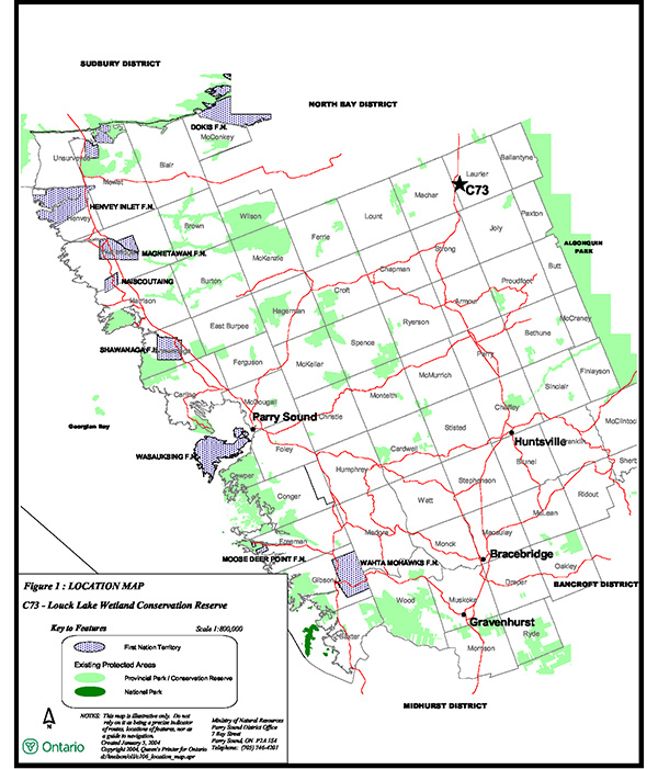
Enlarge Figure 1 – Location Map
Figure 2 – Site map
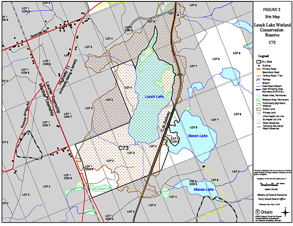
Enlarge Figure 2 – Site Map