Lower Madawaska River Provincial Park Management Plan (Updated 2020)
This document provides direction on the management of Lower Madawaska River Provincial Park.
Approval statement (1987)
Madawaska River Provincial Park is an unrivaled white-water river set in towering forested hills. The combination of flat water and white-water sections, scattered with small but intense rapids of varying degrees of difficulty, make it an attractive river for beginner canoeists and experts alike. Originally used by logging companies in the late 1800's, this river corridor contains exceptional earth science, life science, historical and recreational values, forming a valuable addition to the provincial park system.
We are pleased to approve the Madawaska River Provincial Park Management Plan, as official policy for the management and development of this park. The plan reflects this Ministry’s intent to protect natural and cultural features of the Madawaska River and maintain and develop low-intensity opportunities for outdoor recreation and heritage appreciation for both residents and visitors to the Province.
R.M. Christie
Regional Director
Algonquin Region
Norm R. Richards
Director
Parks and Recreational Areas Branch
1.0 Introduction
The Madawaska River is one of the finest recreational rivers in southern Ontario. Beginning at Source Lake in Algonquin Provincial Park, it traverses 270 kilometres of diverse landscapes and descends 350 metres before it meets the Ottawa River at Arnprior.
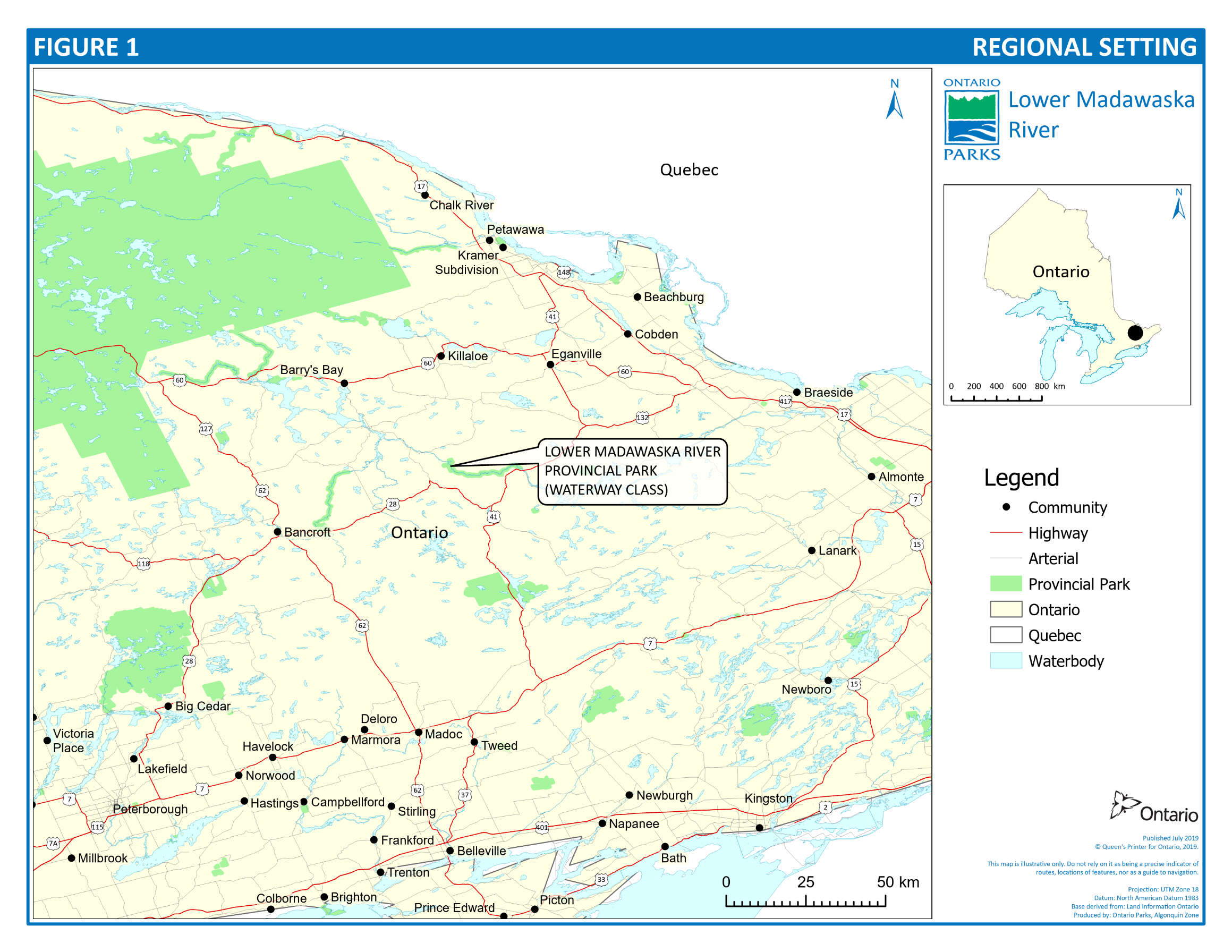
In 1971 a park reserve was established on the Madawaska River between Aumonds Bay and Highland Falls. Located in the southwest corner of Renfrew County in Eastern Ontario, it is approximately 370 kilometres northeast of Toronto and 180 kilometres west of Ottawa (Figure 1).
This 21 kilometre section of the river has special appeal for white water enthusiasts, providing a challenging river for beginners and experts alike. This river also supplies numerous fishing, hunting and hiking opportunities.
It has also been recognized that the river has significant natural and historical features.
The Aumonds Bay Wetland area located just south of Aumonds Bay contains a number of regionally significant plant species. Such unusual species as the showy lady’s slipper (Cypripedium reginae), the yellow lady’s slipper (C. Calceolus var parviflorum), water marigold (Megalodonta beckii), mare’s tail (Hippuris vulgaris), and floating arrowhead (Sagittaria cuneata) not common to this part of Ontario are found here.
Areas located beyond the protection of Lower Madawaska River Park but within the original study area have been identified as being regionally significant and should be considered as areas of natural and scientific interest in order to highlight and protect significant and natural features. These areas include Mount Jamieson (variety of relatively undisturbed forest communities), Highland Creek (unusual plant species in a black ash/black spruce swamp) and Negeek Lake Sandspit (nine vegetative communities representing a variety of sand habitats).
The Madawaska River served as a major spillway draining meltwaters of receding late Wisconsinan ice. A considerable variety of surficial features of glaciation are found in the vicinity of the river, including eskers, kames, outwash plains, terraces, kettles, bay mouth bars, spits, bogs and gravel bars.
The oldest rocks in the area are metasediments deposited 1.5 to 1.25 billion years ago. These metasediments have been cut by a wide variety of plutonic rocks emplaced from 1.3 to 1.0 billion years ago. Metamorphism has converted most of these plutonic rocks into intensely deformed and coarse gneisses and granite pegmatite dikes.
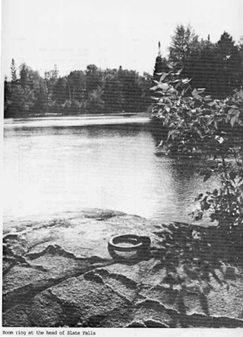
There are numerous examples of historical features within the park left by loggers of the past century. Slate Falls contains the most significant of these features. Names of loggers who lost their lives at this point in the river have been chiseled onto the bedrock. A diversion channel built by the loggers to direct the logs around the falls can still be seen here.
Artifacts left by Indigenous Peoples have also been found. The island at the head of the Snake Rapids is just one of the many sites along the river’s length.
However, some problems have evolved on this unique waterway. During the seventies, use of the river greatly increased and in the Aumonds Bay to Griffith or "Lower Rapids" section, garbage, waste accumulation and over-use of some areas degraded the river environment. Secondly, proposed Ontario Hydro impoundments would have completely altered the river, flooding rapids, deeryards and productive forest lands.
In 1978, an interim Crown land management program was put into effect to protect the river in the short term while long-term plans were being formulated.
A number of alternative ways of managing the river for the future were considered including several forms of Crown land management and the creation of a provincial park. A detailed comparison of alternatives showed that a provincial park would ensure the best protection and management of the waterway for recreational purposes while providing economic benefits to the local community. Subsequently, Ontario Hydro agreed to postpone any consideration of the use of this site until after the year 2000. In the spring of 1981 Premier Davis announced plans for a waterway provincial park on the Madawaska River. A management planning program was initiated in the summer of 1981.
A wide range of information was gathered concerning the waterway. River users and corridor residents have been encouraged to contribute their ideas and opinions. All of this information has provided the basis for the protection, development and management policies set out in this plan.
This approved management plan establishes the direction for the park for a period of twenty years, with opportunities for review and evaluation at least every ten years. This management plan was reviewed and evaluated in 2013. As a result of this review administrative updates were made to this management plan in 2020.
The Provincial Parks and Conservation Reserves Act, 2006 (PPCRA) directs that the ministry shall examine all management direction that has been in place for 20 years or more to determine the need for amendment or replacement of the direction. During that time, the management plan may be examined to address emerging issues or changing conditions and may be adjusted as the need arises.
View a larger version of this map
Figure 1: Regional Setting is a map showing Lower Madawaska River Provincial Park in relation to surrounding provincial parks and towns. This park is located southeast of Algonquin Park and just north of Highway 41.
2.0 Classification
The Lower Madawaska River Provincial Park is managed as a waterway class park under the PPCRA. The objectives of waterway class parks are to protect recreational water routes and representative and significant terrestrial and aquatic ecosystems and associated natural and cultural features and to provide high quality recreational and educational experiences.
3.0 Park goal
The goal of Lower Madawaska River Provincial Park is to protect an outstanding recreational river with its associated natural and cultural features, and to provide a variety of quality outdoor recreational experiences while maintaining ecological integrity.
4.0 Objectives
Lower Madawaska River Provincial Park contributes to the achievement of the four objectives of Ontario’s provincial park system as stated in the PPCRA:
- permanently protect representative ecosystems, biodiversity and provincially significant elements of Ontario’s natural and cultural heritage and to manage these areas to ensure that ecological integrity is maintained
- provide opportunities for ecologically sustainable outdoor recreation opportunities and encourage associated economic benefits
- provide opportunities for residents of Ontario and visitors to increase their knowledge and appreciation of Ontario’s natural and cultural heritage
- facilitate scientific research and to provide points of reference to support monitoring of ecological change on the broader landscape
4.1 Protection objective
To protect provincially significant elements of the natural and cultural landscape of Ontario.
For park system planning purposes, the Ontario landscape is divided into 71 ecodistricts representing landscape-scale patterns of productivity and trends in landform and soil development. The Lower Madawaska River Provincial Park represents the Bancroft Ecodistrict (5E-11) and contains significant earth and life science features. The park will protect a representative portion of the geological and geomorphological history, biological environments and cultural features associated with this area.
4.2 Recreation objective
To provide provincial park outdoor recreation opportunities ranging from high—intensity day use to low—intensity wilderness experiences.
The Lower Madawaska River Provincial Park provides day use, back— country travel and camping opportunities in an area that has outstanding recreational potential. In doing so, the park contributes to the achievement of the waterway class target for Ecodistrict 5E-11 (formerly Site District 11).
4.3 Heritage appreciation objective
To provide opportunities for exploration and appreciation of the outdoor natural and cultural heritage of Ontario.
The Lower Madawaska River Provincial Park will provide the opportunity to explore and appreciate the natural and cultural waterway heritage of the Madawaska Valley in an unstructured, individual way or through self-guided interpretation and education.
5.0 Park boundary
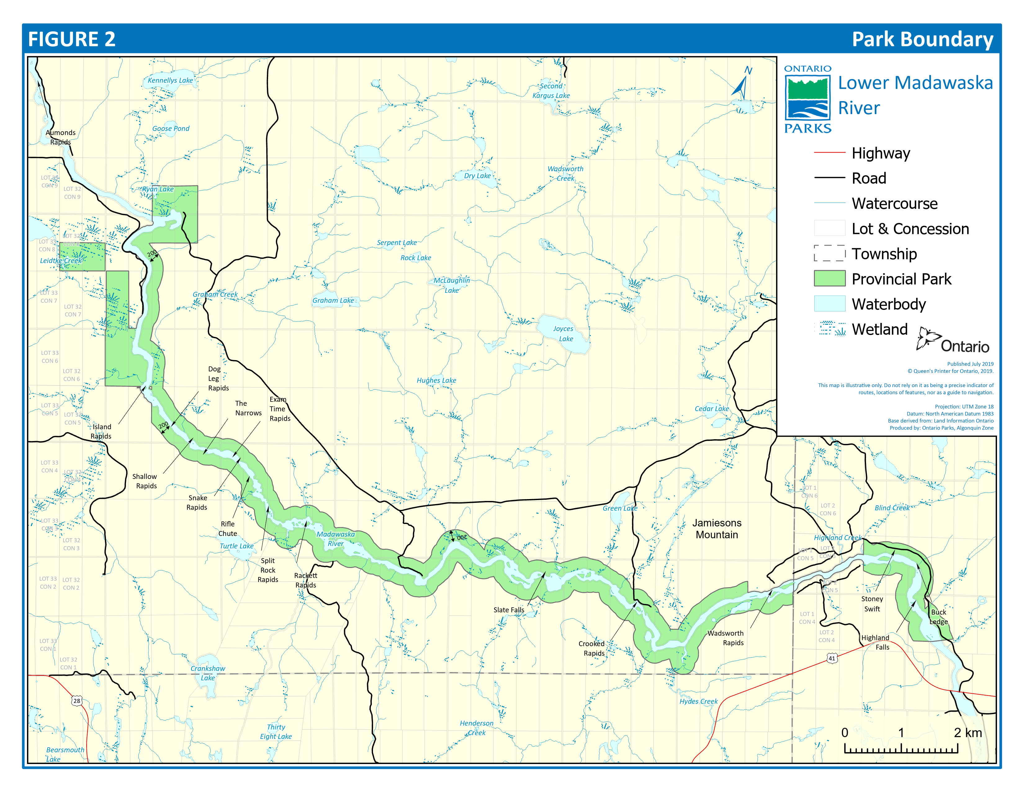
The boundary of Lower Madawaska River Provincial Park includes 1,200 hectares (ha) of Crown land surrounding the river between Aumonds Bay and Griffith (Figure 2).
The boundary will generally consist of a 200 metre setback from both edges of the river. However, at certain locations within this corridor, the boundary extends beyond the 200 metre setback in order to accommodate zoning requirements.
In addition, the boundary encompasses areas of private occupation on Crown land, authorized through land use permits.
Where private land holdings abut the river, the park boundary follows the high-water mark of the Madawaska River. The ministry will not seek to acquire any of these private lands; but will consider the purchase of private lands if they are offered for sale, in order of priority of importance to the park.
Lower Madawaska River Provincial Park is managed by the park superintendent of Bonnechere Provincial Park.
6.0 Zoning
The impetus behind the formation of Lower Madawaska River Provincial Park was primarily one of protection of the quality recreational experience that has attracted visitors for so many years. Secondly, the development of a provincial park is seen to provide positive benefits to the local economy. These two points have provided the basis for the zoning and the associated management and development strategies for the park.
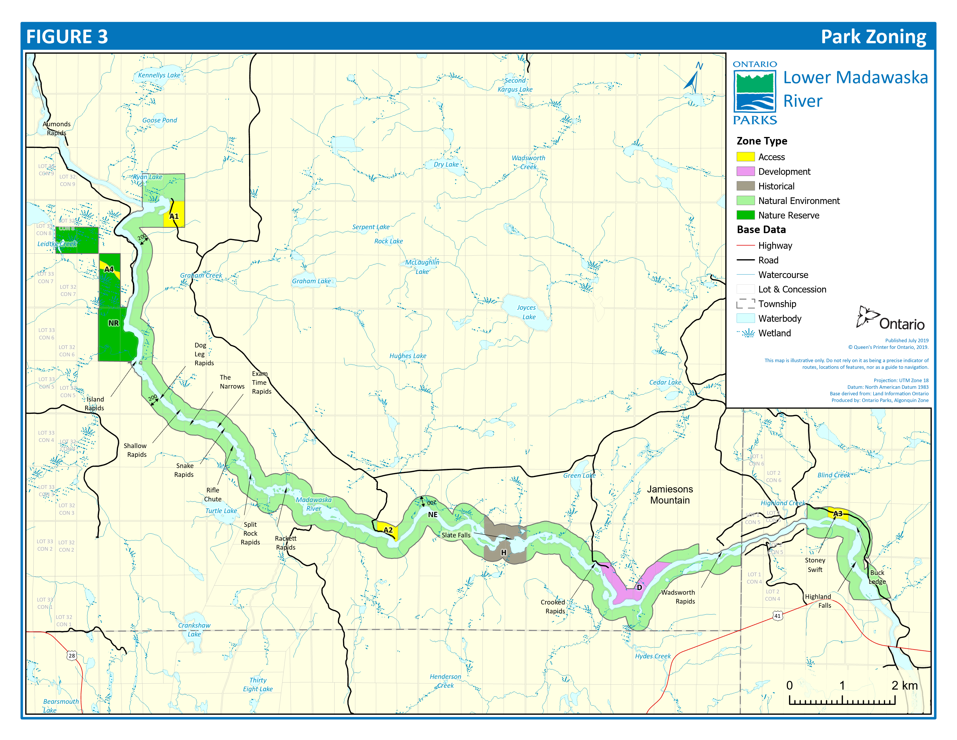
Zoning is essential for the orderly development and effective management of a park. Zoning designations are allocated on the basis of the significance of the land for protection and its potential for recreation within the context of the park’s classification. The parks in each class combine zones in a particular way to provide protection and recreation opportunities distinctive to that class. Waterway parks may include development, access, natural environment, historical, nature reserve and wilderness zones. Lower Madawaska River Provincial Park will include the first five of these zone types (Figure 3).
6.1 Development zone
Development zones accommodate facilities and services for a wide range of day use and camping activities such as base camps for those recreationists using specific sections of the river. Built to specific standards, such facilities will alleviate problems associated with conflicts among users, overuse of interior campsites, provide for uncrowded conditions and alleviate trespassing on private lands.
View a larger version of this map
Figure 2: Park Boundary is a map showing the park's boundary being mostly 200 metres from water's edge of Madawaska River, significant features such as rapids along with roads and highways around this park.
View a larger version of this map
Figure 3: Park Zoning is a map showing the areas in Lower Madawaska River Provincial Park zoned as either an access zone, a development zone, historical zone, natural environment zone or nature reserve zone.
6.1.1 Mt. Jamieson (34 ha)
This zone is located on the north side of the river at the foot of Mt. Jamieson just below Crooked Rapids.
6.2 Access zones (31 ha)
Access zones serve as staging areas where minimum facilities support the use of the waterway. Development will be restricted to roads, parking spaces, picnic, interpretive and sanitary facilities. There will be four access zones within the park.
6.2.1 Aumonds Bay (19 ha)
This zone (Al) identifies Aumonds Bay as a major access point. Existing facilities will be upgraded accordingly.
6.2.2 Buck Bay (8 ha)
This is another major access/egress point (A2), which will be upgraded accordingly.
6.2.3 Highland Creek (3 ha)
A small area on the Madawaska near Highland Creek will be provided as an egress point (A3) for those travelling the length of the park.
6.2.4 Access corridor (1 ha)
This zone (A4) identifies an old logging access road to provide traditional A.T.V. access from Lot 29, Concession VII to Lot 31, Concession VII through the nature reserve zone. All vehicular travel must remain within this zone while passing through the nature reserve.
6.3 Natural environment zone (956 ha)
Natural environment zones include sections of the corridor in which minimum development is required to support low-intensity recreational water travel activities and to protect associated aesthetic landscapes.
Development will be limited to back—country campsites, portages, trails, necessary signs for route identification, and minimal interpretive facilities.
The Madawaska River and its tributaries contain unusual aquatic flora. Water marigold, mare’s tail and floating arrowhead, which are all rare in the region, occur at the mouths of Snake and Leidtke Creeks. Dense narrow bands of burreed (Sparganium amaricanum), wild rice (Zizania Aquatica), spike — rush (Eleocharis palustris) and sweetflag (Acorus calamus) occur along the river and at the mouth of Snake Creek. Sweetflag is a southern species, which is uncommon in the region, and is approaching the northern limit of its range here.
This zone includes a 200 metre strip on each side of the river on Crown lands between Aumonds Bay and Highland Falls. The resources within these areas will be managed exclusively for low intensity recreation and protection purposes.
6.4 Historical zone
Historical zones include significant historical resources providing outstanding opportunities to interpret historic waterway uses and activities. Such zones require management distinct from that in adjacent zones. Development will be limited to portages, trails, and interpretive displays.
6.4.1 Slate Falls (41 ha)
This zone is located on both sides of the river at Slate Falls. It has the greatest concentration of historic features within the park. Special management considerations will be given to the protection of a display of logger names carved in the rock and the improvements they made to the river to move the logs past Slate Falls.
6.5 Nature reserve zone
Nature reserve zones include significant life and earth science features, which require management distinct from that in adjacent zones.
Development will be limited to trails, necessary signs, and minimal interpretive facilities and temporary facilities for research.
6.5.1 Aumonds Bay wetlands (138 ha)
This zone is located along the shore southwest of Aumonds Bay. It includes a large wetland complex of high representative value, characterized by large swamps and boggy areas. The bogs support unusual flora, which are rare in Ecoregion 5E.
Two rare orchids, showy lady’s slipper and yellow lady’s slipper are found in a white cedar—tamarack bog in the southern portion of the wetlands. Both orchids are southern species, which prefer limestone substrates and are thus very rare in this region. This is the only known existing site for the showy lady’s slipper in the region.
The remaining expanse of Aumonds Bay wetlands will be incorporated within the park’s boundaries as opportunities permit on the basis of properties being offered to this ministry and the availability of funding.
7.0 Resource management strategies
7.1 Vegetation management
Damage to vegetation will continue to be monitored to ensure damage is contained to a reasonable footprint in all developed areas and that areas sensitive to disturbance are not impacted. No person shall disturb, cut, kill, remove or harm any plant, tree or natural object in a provincial park without the written authorization of the Park Superintendent, as stated in Ontario Regulation 347/07 Provincial Park: General Provisions of the PPCRA. Any authorized vegetation management will follow the Class Environmental Assessment for Provincial Parks and Conservation Reserves (Class EA PPCR). Mitigation measures will be in place when managing vegetation to ensure this work is conducted in a way which considers ecological integrity.
Trees cut for development and management purposes will be retained for various park uses. Alien and invasive plant species will not be introduced.
Insects and diseases threatening park values will be controlled where feasible to maintain ecological integrity. Where control is desirable, it will be directed as narrowly as possible to the specific insect or disease so as to have minimal effects on other components of the park’s environment. Biological control will be used wherever feasible.
Forest fires within the park would be ecologically appropriate. However, due to the narrow width of the park, use of natural fire within the park is likely not to occur.
The Wildland Fire Management Strategy (2014) provides strategic direction for the Ministry of Natural Resources and Forestry’s management of wildland fire within the province of Ontario. The use of fire can offer excellent ecological benefits. As part of this strategy wildland fires in provincial parks may be monitored to maintain or enhance ecological integrity, when it is safe to do so.
Vegetation management will vary accordingly in the following zones, which constitute Lower Madawaska River Provincial Park. Commercial timber harvest shall not occur within this park.
7.1.1 Mt. Jamieson development zone
Native species may be used for site rehabilitation.
Development and management efforts in this zone will be aimed at preserving as much of the natural character of the area as possible.
7.1.2 Aumonds Bay, Buck Bay, Highland Creek access zones
Trees may be cut for purposes of safety, roads, trails and parking only.
Vegetation alterations will be allowed only to achieve the purpose of the zones which is to serve as staging areas where minimum facilities support use of the waterway. This includes maintenance of the canoe-in sites in Aumonds Bay, to support the access of paddlers from Palmer Rapids.
7.1.3 Slate Falls historical zone
Cutting in this zone will only be allowed for purposes of safety, trail maintenance, and portage maintenance. Native species may be used for site rehabilitation.
7.1.4 Aumonds Bay wetlands nature reserve
Natural succession will be allowed to progress unimpeded.
7.1.5 Natural environment zone
Cutting in this zone type will only be allowed for purposes of safety, trail maintenance, and portage and campsite development and maintenance. Native species may be used for site rehabilitation. Herbicides may be used to control poison ivy in areas of concentrated recreational use such as portages.
7.2 Fisheries
Existing sport fishing opportunities within the park area will be increased through the provision of additional access and camping facilities. Native fish species such as walleye (Stizostedion vitreum) may be stocked. Spawning and nursery areas will be protected through increased management efforts.
Waterbodies may be closed to fishing temporarily for fisheries research or management purposes. Although Green Lake is not incorporated in the park, it will be managed as a put—and—take fishery.
7.2.1 Bait harvest areas
Lower Madawaska River Provincial Park includes portions of five bait harvest areas: PE0225, PE0221, PE0208, PE0224, and PE0214. Commercial bait harvesting will be permitted to continue within the park except for the portions of the bait harvest areas located in Aumonds Bay Wetlands Nature Reserve Zone. The commercial bait harvesting rights to this area will be phased out, in accordance with the Permitted Use Policy Amendment, 2010. Existing bait harvest areas outside of the nature reserve zone are permitted to continue indefinitely.
7.3 Wildlife
Animal populations may be controlled when essential to protect human health and safety or the health of the species outside the park. Where special control is desirable, techniques will be used having minimal effects on other components of the park’s ecological integrity. Any special population control measures will be carried out under the strict supervision of or directly by Ontario Parks.
Alien and invasive animal species will not be introduced in the park.
7.3.1 Trapping
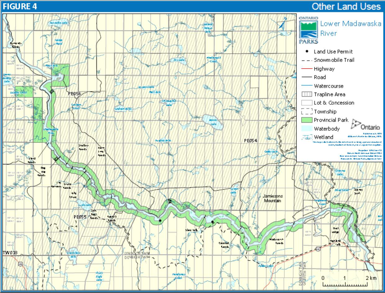
Small portions of three registered traplines exist inside the park: PE055, PE056, and PE054 (Figure 4). Trapping will be allowed to continue within the park except for the trapline located in the Aumonds Bay Wetlands Nature Reserve Zone. The trapping rights to this area will be phased out in accordance with the Permitted Use Policy Amendment, 2010. Existing registered traplines outside of the nature reserve zone are permitted to continue indefinitely.
There is minimal conflict between trapping and recreational users during the trapping season. However, potential problems can be avoided through visitor and trapper education, and through spatial separation of trapping activities and recreational facilities.
Administration and management of registered traplines is managed by the Ministry of Natural Resources and Forestry.
7.3.2 Hunting
Hunting is permitted to occur in the natural environment zone of this park in accordance with regulations made under the Fish and Wildlife Conservation Act, 1997.
7.3.3 Private recreation camps
Two private recreation camps are located inside the park boundary along the river (Figure 4).These recreation camps are permitted within this park under the terms and conditions of land use permits, which are issued for up to five years at a time and are eligible to be renewed upon expiry for the lifetime of the current permit holder.
Private recreation camps within the Lower Madawaska River Provincial Park are subject to the Permitted Use Policy Amendment (aka “phase out”), 2010. Subject to this policy existing, private recreation camps may continue for the lifetime of the permit holder, being the permit holder on October 30, 2009. Improvements will be limited, and the estate will have up to one year to remove improvements following the passing of the permit holder. No land use permits will be issued for new recreation camps within the park. Any additions or alterations to existing camps will require prior approval of the park superintendent.
7.3.4 Bear management areas
Lower Madawaska River Provincial Park includes portions of two bear management areas: TW-58-008 and PE-58-006. Hunting, including commercial bear hunting, is permitted to continue in the natural environment zone of this park in accordance with regulations made under the Fish and Wildlife Conservation Act, 1997.
View a larger version of this map
Figure 4: Other Land Uses is a map showing four key markers which include deer wintering area, snowmobile trails, hunting camps, and registered trapping lines within the park boundary.
7.4 Water resources and control
No new water control structures will be built within the park. New commercial hydroelectric development will not be permitted.
Management of the Madawaska River water level and flow is guided by the Madawaska River Water Management Plan produced by Ontario Power Generation with support from the Ministry of Natural Resources and Forestry.
7.5 Cultural resources
Slate Falls has the greatest concentration of historical logging features within the park. This area contains various types of historical examples that have been noted along the river from Aumonds Bay to Highland Falls, including a site where the names of loggers who died on the river were carved into the bedrock. The concentration of features and the special importance of the loggers’ memorial make Slate Falls the major heritage resource along the river.
While most of the historical features in the park are not sensitive to continued recreational use, the names carved in the rock are an exception. Already most of the names are illegible and continued use of the portage that is located adjacent to this site will lead to further deterioration of the carvings. To prevent further deterioration of the carvings the Slate Falls portage has been re-routed to the rock cut and slide area.
The rock carvings require special attention. First, action shall be taken to discourage use of the former portage and encourage use of the newer portage at the rock cut and slide area. This has two advantages; it exposes the route of the slide for interpretation, and it keeps the portage close to the names so that they, too, can be viewed. Secondly, the former portage route must be intensively examined to identify all rock faces upon which names have been carved. There are probably more names and older dates that are not visible, covered by underbrush and debris. The site will be photographed and mapped, and steps will be taken to protect and display the names. This could include highlighting the names (as was done at Petroglyphs Provincial Park) and ensuring that travelers can view the names without touching or walking on them.
One of the oldest buildings within Lower Madawaska River Provincial Park is the Buck Bay ‘Sentinel’ Cabin. This cabin is located on the north shore of Buck Bay along the Madawaska River. It is estimated this cabin was built in the 1930s as a trapper’s cabin (Campbell et al, 1982). Today this cabin can be visited by park users enjoying the river and the natural setting around this cabin.
7.6 Mining
No prospecting, staking mining claims, developing mineral interests or working mines will be permitted within the park.
7.7 Utilities
No new crossings of rail or utility lines or highways will be permitted within the park. Utility lines may be established in the park for park purposes. A provincial multi-site PPCRA land use permit has been issued to Hydro One for utility lines within provincial parks, including the lines within this park.
Maintenance of the existing utility lines will be permitted. These activities must adhere to the regulations set out under relevant acts (e.g., Environmental Assessment Act, Provincial Parks and Conservation Reserves Act).
7.8 Snowmobiling
Snowmobiling will be allowed to continue within the park but only along traditionally used trail routes. Trail utilization will be monitored to identify future use control.
8.0 Operations strategies
Ontario Parks will maintain a park operations plan to provide staff with the necessary direction to manage the park on a day-to-day basis. The park operations plan will include such topics as budget, staffing, maintenance schedules, enforcement and emergency management. The provisions of the park operations plan will be consistent with park policy and Ontario Parks Operating Standards (MNRF 2018).
Management systems will be established for garbage cleanup and general maintenance of campsites, portages, and trails in the natural environment, development, historical, and access zones. This strategy will include the following general principles:
- Solid waste from campgrounds located in the development zone will be disposed of outside the park.
- Existing forest access roads other than those required for the purposes of this plan will be gated at the park boundary. Keys will be provided where necessary for recreation camp and park management purposes.
- No person shall enter the park by any means except at a point designated for the purpose of entry by the park superintendent.
- Motor vehicles, or all-terrain vehicles as defined in the Provincial Parks and Conservation Reserves Act, 2006 Ontario Regulation 347/07, will be allowed in the park only on designated roads or trails, in access and development zones, except where required for park management purposes.
Until such time that a garbage cleanup system may be in place, park users are expected to pack in and pack out of the entire park. This direction will be communicated by park signage and messaging on the Ontario Parks website.
A number of opportunities for private sector involvement in the provision of operational alternatives and complementary services may occur. The park superintendent may enter into agreements with service providers for the maintenance of campsites, portage trails and access points.
8.1 Visitor services
Lower Madawaska River Provincial Park provides a scenic landscape for visitor self-guided interpretation. Major facilities will not be provided, but personal exploration of the park and surrounding areas will be encouraged.
8.1.1 Information
Public information services will be directed towards providing information on river travel in order to enhance the ability of the visitors to use the river safely and to explore and appreciate its resources. Information on this park can be found on the Ontario Parks website or by contacting the Bonnechere Provincial Park Office.
8.1.2 Interpretation
Madawaska River has a significant story to tell in the provincial park system. The role of the river in the evolution of the natural and cultural landscape of the Madawaska Valley provides ample scope for interpretation. Geological features, the fur trade, logging, mining, and agricultural activities can all be interpreted when moving through the valley, either by road or on the water. Different aspects of the theme may be interpreted for tourists, fishermen and back—country paddlers.
The Lower Madawaska River Provincial Park offers a good opportunity to integrate heritage appreciation with other recreational activities. Although none of the park’s heritage resources are of excellent quality, they lend themselves to a low-key program of appreciation and exploration.
8.1.3 Recreation programming
The river valley offers excellent opportunities for a wide variety of recreational activities, but especially for white water canoeing and kayaking. Private sector programming may be offered to develop waterway skills to visitors in conjunction with private sector instructors or schools.
Canoeing and kayaking competitions conducted by private associations or clubs will be permitted in the park. These will be arranged well in advance of the competition date and will require the approval of the park superintendent. Park campsites may be reserved for this purpose. No additional facilities will be built for spectator or communication purposes.
8.1.4 Recreation management
Recreational use of Lower Madawaska River Provincial Park has increased greatly over the years creating major conflicts with the resource potential. Easy vehicle access and camping along the scenic sections of white water, over-use of some areas and the accumulation of garbage and waste has resulted in the deterioration of the river’s ecological integrity. White water users were being displaced by car campers, leading to further pressures on shoreline sites and island campsites. As a result, an interim Crown land management program was established in 1978 in order to control car camping and protect the river environment until the park’s management plan could be developed.
The interim management program closed the Crown land portion of the river below Aumonds Bay to all vehicular access (i.e., forest access roads to the river). Camping is now prohibited at all access points. Access to the river is via four access points while limiting camping to boat—in sites only.
Lower Madawaska River Provincial Park is now subject to a monitoring process to identify problems or conflicts and to introduce the possibility of user controls. The control of park users plays a significant role in the managed use and retention of the character of the park.
One consideration to alleviate the problem of overcrowding would be the introduction of access point quotas. If the system of access points is put into operation, adjustments in quotas would be made according to camping demands.
At present, camping sites, portages and access points are monitored by means of a limited maintenance program of signage (i.e., no camping, park boundary),earth pit privies maintenance at identified campsites as well as Aumonds Bay and Buck Bay access points, area clean—ups, minimal road maintenance (within the park boundary) and clearing and marking of designated portages and campsites. This park is part of the Algonquin Zone non-operating parks monitoring program and is patrolled by park staff to ensure users are conforming to the intended use policy.
8.2 Research
Research by qualified individuals, which contributes to knowledge of our natural and cultural history, and the environmental and recreational management of waterways, will be encouraged in the park. Consideration will be given for future ecological surveys to map and describe the flora and fauna of the park for management purposes.
An archaeological inventory of the river corridor in the summer of 1981 identified important sites requiring further investigation. This research will be given a high priority so that the sites may be examined before there is further deterioration from recreational use.
All research at Lower Madawaska River Provincial Park will be conducted by, or authorized by, Ontario Parks. Researchers must apply to conduct research and receive approval prior to starting work in the park. All research projects must also meet all requirements under applicable provincial and federal legislation. Approved research activities and facilities will be compatible with protection objectives and recreational uses in the park, and will be subject to development and management policies for waterway class parks unless special permission is given. Sites altered by research activities will be rehabilitated as closely to their previous condition as possible.
8.3 Marketing
Lower Madawaska River Provincial Park will be operated consistent with the overall marketing strategy of Ontario Parks.
8.4 Access roads
Lower Madawaska River Provincial Park can be reached by water and land.
Hyland Creek Road runs parallel to the Madawaska River for most of its length as Lower Madawaska River Provincial Park. Existing tertiary roads branch off Hyland Creek Road south and provide access to this park. These roads are not maintained by Ontario Parks.
9.0 Development strategies
New development on the river will be kept to a minimum with the exception of the Mt. Jamieson development zone. The existing facilities will have redirection to control use, capacity standards of the river, and act as safeguards against unregulated and indiscriminate backcountry use and camping. Development will proceed in accordance with Figure 5 and the following guidelines. In all instances, detailed site plans will be completed and approved in advance of rehabilitation of existing facilities or the development of new facilities. Development projects will be phased according to the Implementation Strategy (Section 10.0) as needed and funding permits. All development will adhere to the requirements of the Environmental Assessment Act.
9.1 Development zone
9.1.1 Mt. Jamieson
The area on the north side of the river at the foot of Mt. Jamieson has been identified as a campground development area. It will be designed to mainly cater to paddlers and anglers. Walk—in sites will be provided to accommodate 80 visitors, the majority being designed for group use. Toilet and basin unit privies, a small water system, a centralized garbage facility and firewood will be provided. Parking spaces and a turn-around loop will be provided well back from the river. The existing access road linking this area with the Green Lake Road will be upgraded.
9.2 Access zones
9.2.1 Aumonds Bay
Aumonds Bay will be maintained as an access and egress point for river users. Parking spaces, a turn — around loop, and privies are provided; garbage disposal facility, and picnic facilities will be provided.
9.2.2 Buck Bay
The road to Buck Bay will remain open as an access and egress point for paddlers. The road ends at a turn —around loop well back from the river. A parking lot and earth pit privies are provided along the road. Garbage disposal facility will be provided as well. Until such time that garbage disposal facilities are established visitors are expected to pack in and pack out.
9.2.3 Highland Creek
A small parking lot and turn -around loop will be provided on Crown land east of Highland Creek and south of the Green Lake Road, as an egress point on the river. A garbage disposal facility and privies will be provided here as well.
View a larger version of this map
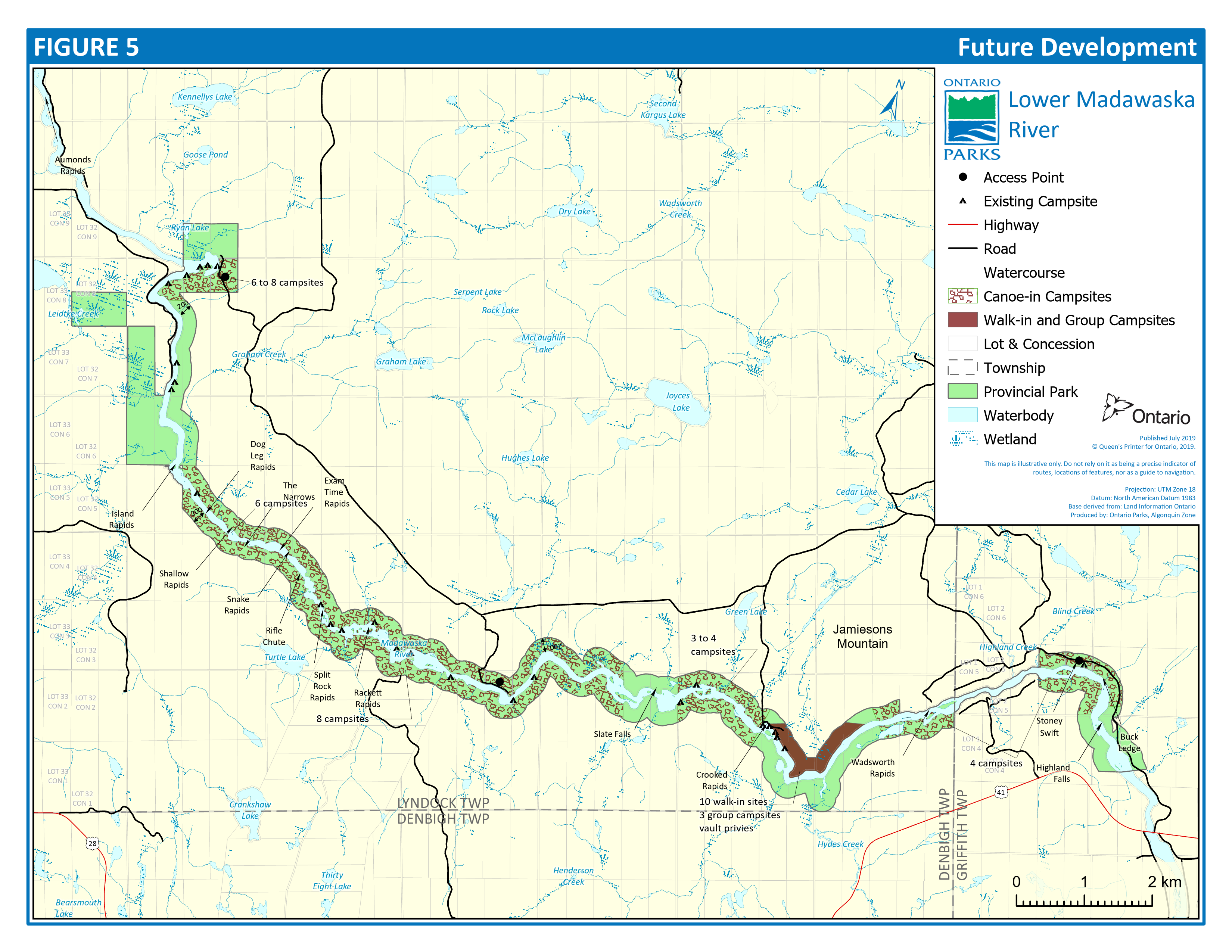
Figure 5: Future Development is a map showing existing campsites that have been developed as of summer 2019 and identifies areas where there is a potential for more campsite development.
9.2.4 Access to park boundary
In addition to the access roads to the three access points mentioned above, there are two old forest roads that in the past provided access to and egress from the river. One runs from the Green Lake Road to the Rackett Rapids area and the other from Green Lake Road to the Slate Falls area on the river.
Both roads will be gated at the park boundary. However, vehicles can get within approximately 180 metres of the river providing anglers access to the river and emergency egress from the river by river users. Motorized access past these gates requires authorization by the park superintendent.
9.3 Natural environment zone
Individual campsites, similar to those in the interior of Algonquin Provincial Park will be established along the river throughout the park. As of 2019, 26 campsites had been established. The river has the potential to support approximately 30 sites. The exact location of these sites is determined in the field. Figure 5 "Future Development" indicates the approximate number of sites to be located along particular stretches of the river and the locations of sites developed so far. For example, six to eight campsites are indicated to be developed in the vicinity of Aumonds Bay, five campsite locations in this area have been developed. These sites are to accommodate park visitors coming downstream from Palmer Rapids and those arriving late in the day to the Aumonds Bay access point. The remainder of the sites along the river will accommodate visitors utilizing a stretch of the river or just travelling through.
Space for two tents will be available at each site and a box privy will be provided at least 30 metres back from the shore. Although the use of stoves is encouraged, a fireplace location will be identified on each site.
Campsites on islands will be rehabilitated and no-camping signs have been installed. The islands are too small to support continued camping use and sanitary facilities. A few of them have already been severely degraded by over—use. They may, of course, still be used for meal stops, swimming and portaging. A stove-only approach to cooking meals will be encouraged as firewood is in short supply on most of the islands.
Two new trails will be established in the park. The feasibility and development of the trails could be considered with potential development in the Mt. Jamieson Development Zone. Trail construction should not occur prior to development in the Mt. Jamieson area. The Mt. Jamieson trail will begin in the Mt. Jamieson Development Zone and will follow the present road up the west side to the summit. At the present time, there is a spectacular view to the west, up the Madawaska Valley. The footings of an old fire tower are located here, creating the possibility of re-erecting a type of lookout tower to provide panoramic views of the river corridor. A return loop will descend the mountain on the east side.
A second trail will be established for river travelers on the south side of the river near Split Rapids and Rackett Rapids. This 3 kilometre trail will provide access to Turtle Lake, a small, relatively remote and picturesque brook trout lake. This trail could also be of assistance in the interpretation of a post—glacial drainage channel at the east end of Turtle Lake, which has been identified as a significant earth science feature.
Since these trails extend beyond the boundaries of the park, Ontario Parks will work with the Ministry of Natural Resources and Forestry to ensure all necessary requirements are met prior to any trail work occurring.
9.4 Historical zone
9.4.1 Slate Falls
Campsites within the Slate Falls Historical Zone will be posted for no-camping. Camping in historical zones is not compatible with the values this zone protects. Development will be limited to portages, trails, and interpretive displays.
10.0 Implementation strategy
The management plan will be examined every ten years following its approval or as the need arises. Data collection and environmental monitoring will be conducted regularly.
Below is a list of projects that have been previously described in this Plan. This list appears in chronological order according to the individual project priority. The number of projects to be completed or partially completed will be based upon the availability and allocation of each year’s capital funding.
| Priority Rating | Project Description |
|---|---|
| 1 | Construct access points at Aumonds Bay, Buck Bay and Highland Creek |
| 2 | Develop interior campsites along the river, closing existing ones that are not appropriate. |
| 3 | Develop walking trails at Mt. Jamieson and into Turtle Lake. |
| 4 | Develop Mt. Jamieson campground |
11.0 Public consultation
The planning process for the Madawaska River continued in 1980 - 81. In the summer of 1981, a display was set up at the Palmer Rapids Work Centre showing the background information that had been collected. The public was invited to visit the centre and view and comment on the information presented.
In February 1982, a newsletter was sent out informing interested public that the planning process for the proposed Madawaska River Park had been put on hold until the completion of the Pembroke District Land Use Guidelines. Park management planning was resumed in 1983 and a preliminary management plan for the Madawaska River Waterway Provincial Park was completed in July 1984. A summary of the preliminary plan was produced in a tabloid format and was given wide distribution. The draft management plan set out guidelines for the protection, development and management of the proposed waterway park, which included the area of the Madawaska River from McFees Bay near Palmer Rapids to just south of Highland Falls near the Village of Griffith. The proposed management strategy provided details on how the river could be developed and managed to accommodate river users, yet protect its recreational, natural and historical characteristics. The plan met with considerable opposition; particularly from local residents and property owners who felt that traditional river uses would be jeopardized with the establishment of a park in that area.
In response to these expressed concerns, a public meeting was held in Combermere on November 26, 1984. At this meeting, which was attended by approximately 300 people, a commitment was made to form a user/interest group committee to advise and assist the planning team in the resolution of the key planning issues. A series of meetings were held with this user group and this plan responds to the input received.
The park size was reduced during the issues planning meetings eliminating proposed parklands between McFee Bay and Aumonds Bay, thus solving most problems concerning private land ownership and possible conflicts with park recreation users.
12.0 References
Biggar, H.P. 1922-1936. The Works of Samuel de Champlain (ed.), 6 vol. Toronto. Maps Toronto Champlain Society.
Campbell, Paul and Peters, John. 1982. Madawaska Waterway Park: Historical Planning Report. Toronto.
Department of the Environment. 1974. The Tourist and Outdoor Recreation Climate of Ontario, R.B. Crowe, G.A. McKay and W.M. Baker. Toronto: Volumes Two and Three Atmospheric Environment Service.
Dunn, Guillaume. 1975. Las Forts de l’Outaouais. Montreal. P.Q.
Environmental Assessment Act, (R.S.O. 1990, c. E. 18).
Fish and Wildlife Conservation Act, 1997.
Kennedy, C. 1970. The Upper Ottawa Valley. Pembroke.
Lumbers, S.B. 1980. Geology of Renfrew County, Southern Ontario. Toronto: Survey Open File Report 5282, 118, p.1.
Ontario Department of Lands and Forests. 1963. Algonquin Story. A. Saunders.
Ontario Ministry of Natural Resources. 1975. Background Information, Pembroke District, Algonquin. Algonquin Region: Parks and Recreational Areas Branch.
Ontario Ministry of Natural Resources. 1977. Summary Report on the Interior site Plan for Algonquin Park. C.K. MacDonald. Algonquin Region: Parks and Recreational Areas Branch.
Ontario Ministry of Natural Resources. 1978. A Brief Life Science Inventory of the Madawaska River (Whitney to Madawaska). L. Dickson. Algonquin Region: Unpublished Report Parks and Recreational Areas Branch.
Ontario Ministry of Natural Resources. 1979 (Revised 1980 by C. M. Spek). Surficial Geology of the Madawaska River McFee’s Bay to Griffith Environmental Planning Series. T.W.D. Edwards. Algonquin Region: Parks and Recreational Areas Branch.
Ontario Ministry of Natural Resources. 1979 (Revised 1980 by H. Simpson). A Reconnaissance Life Science Inventory of the Madawaska Wild River Park Reserve (from McFee’s Bay to Griffith). T. Dempsey. Algonquin Region: Parks and Recreational Areas Branch.
Ontario Ministry of Natural Resources. 1980. A Framework for the Conservation of Ontario’s Biological Heritage, T.J. Beechey. Toronto: Unpublished manuscript, Parks and Recreational Areas Branch.
Ontario Ministry of Natural Resources. 1980. Earth Science Checksheets for Pembroke District Parks Park Reserves and Proposals. Algonquin Region: Parks and Recreational Areas Branch.
Ontario Ministry of Natural Resources. 1980. Life Science Checksheets for Pembroke District Parks Park Reserves and Proposals. Algonquin Region: Parks and Recreational Areas Branch.
Ontario Ministry of Natural Resources. 1981. An Archaeological Survey of the Proposed Madawaska Waterway Park. J.B. Jamieson. Pembroke: Parks and Recreational Areas Branch.
Ontario Ministry of Natural Resources. 1981. District Land Use Plan, Parks and Recreational Areas Program Requirements. Algonquin Region: Parks and Recreational Areas Branch.
Ontario Ministry of Natural Resources. 1981. Madawaska River Park Reserve Heritage Planning Study. P.L. Campbell and J.H. Peters. Pembroke: Parks and Recreational Areas Branch.
Ontario Ministry of Natural Resources. 1981. Provincial Park Master Planning Guidelines, Currie, A.J. Travers, R. Beatty. Toronto: Parks and Recreational Areas Branch.
Ontario Ministry of Natural Resources. 1983. Pembroke District Land Use Guidelines. Regional Lands Office.
Ontario Ministry of Natural Resources. 1992. Ontario Provincial Parks: Planning and Management Policies. Queen’s Printer for Ontario.
Ontario Ministry of Natural Resources. 1999. Ontario’s Living Legacy Land Use Strategy. Queen’s Printer for Ontario.
Ontario Ministry of Natural Resources. 2005. A Class Environmental Assessment for Provincial Parks and Conservation Reserves. Queen’s Printer for Ontario.
Ontario Ministry of Natural Resources. 2010. Permitted Use Policy Amendment (aka “phase out”). Ontario Parks, 2010.
Ontario Ministry of Natural Resources. 2014. Ontario’s Protected Areas Planning Manual: 2014 Edition. Peterborough: Queens Printer for Ontario.
Ontario Ministry of Natural Resources and Forestry. 2014. Wildland Fire Management Strategy, Toronto: Queen’s Printer for Ontario.
Ontario Ministry of Natural Resources and Forestry. 2018. Ontario Parks Operating Standards, Version 2.
Provincial Parks and Conservation Reserves Act, 2006.
Trigger, B.G. 1976. The Children of Aataentsic, A History of the Huron People to 1660. Montreal.