MacLeod Provincial Park Management Plan
This document provides policy direction for the protection, development and management of MacLeod Provincial Park and its resources.
© 1987, Queens Printer for Ontario
Additional Copies of this publication are available for $5.00 from:
Ministry of Natural Resources
Geraldton District Office
P.O. Box 640
208 Beamish Avenue west
Geraldton, Ontario
P0T 1M0
And
Ontario Government Book Store
880 Bay Street
Toronto, Ontario
M7A 1N8
Mail Orders: Contact the Geraldton District Office. Telephone (807) 854-1030.
Or contact MGS Publications Services Section, 5th Floor, 880 Bay Street,
Toronto, Ontario.
M7A 1N8. Telephone 965-6015, or Toll Free long distance 1-800-268-7540, in Area Code 807, dial 0 - Zenith 67200.
Cheques or money orders should be made payable to the Treasurer of Ontario, and payment must accompany the order.
Note: This is document has been scanned and formatted, and therefore is slightly different from the original version. March 2002
Approval statement
MacLeod Provincial Park is located off Highway 11 on Kenogamisis Lake, 10 kilometres east of Geraldton. This 74 hectare recreation class park was placed in regulation in 1963, when acquisition of the surface rights for the land holdings had been finalized.
The park, named after Fred MacLeod, a gold prospector, boasts a high quality beach, and an 85 site campground, with 28 electrical sites and a comfort station. Local residents and the travelling public take advantage of the park on a day use basis to swim, picnic, relax on the beach, or take a hike on the nature trail.
Overnight camping in the campground attracts families and groups journeying on Highway 11 and area residents on vacation, as Kenogamisis Lake offers fine sport fishing opportunities and an attractive setting for many forms of family-centred recreational activity.
We are pleased to approve the MacLeod Provincial Park Management Plan as official policy for the management and development of this park. The plan reflects this Ministry’s intent to protect the natural and cultural features found in MacLeod Provincial Park and maintain high quality opportunities for outdoor recreation and heritage appreciation, for both residents of Ontario and visitors to the Province.
Signed by:
G.P. Elliott
Regional Director
North Central Region
Date: August 28, 1987
Signed by:
N.R. Richards
Director
Parks and Recreational
Areas Branch
Date: September 17, 1987
1.0 Introduction
MacLeod Provincial Park is a 74 hectare park located 10 kilometres east of Geraldton on Highway 11, (see Figure 1). The Department of Lands and Forests acquired the surface rights from a number of different owners and the park was placed in regulation in 1963. The park was named after Fred MacLeod, one of the discovers of the MacLeod-Cockshutt gold mine which had operated nearby.
The surficial geology of MacLeod Provincial Park consists of glacial outwash deposits which formed the fine recreational beach. The underlying bedrock consists of meta-volcanic rock. Bedrock outcrops scattered throughout the park have been scratched and moulded by the glacial ice. The primary vegetation component is a fire-originated aspen stand resulting from a 1939 blaze which burned most of the park area. Because of the small size of the park and the park development and use, these natural features are not considered significant.
Two archaeological sites have been identified. These sites show representation from the fur trade theme segments of Ontario history. One site has produced quantities of early French fur trade artifacts which makes it an important site, at least in a regional context.
Prior to the area becoming a provincial park, local people had used the beach area for recreation. In 1956 and 1957, improvements were made to the access road to the beach, four privies were built and 15 campsites were cleared. Since becoming a provincial park, the following development has occurred:
- 85 campsites (28 with electricity)
- a group picnic and day use area
- vault toilets, running water and a comfort station
- a park office and various maintenance buildings
- a self-guided nature trail
Day users of MacLeod Provincial Park are primarily local people from Geraldton and Longlac who come to swim, picnic or relax. Individuals and groups frequently use the nature trail. In the winter, the park is used by cross-country skiers and snowshoers.
Most campers use the park as a convenient stopover during their vacation. The 1984 camper survey indicated that the average length of stay was 2.3 days. People spent most of their time relaxing, with fishing being the second most popular activity. In fact, one of the most attractive features of MacLeod Provincial Park is its location on Kenogamisis Lake, a lake which offers fine sport fishing opportunities.
2.0 Major issues
This management plan address four major issues.
1. Land Tenure
When the surface rights were acquired from Oklend Gold Mines Ltd. and Consolidated Mosher, these companies retained the right to enter, explore and mine in the park. The legal agreements entered into by the Minister of the Department of Lands and Forests were explicit in allowing unimpeded mineral exploration and mining activity, where the mineral rights have been retained.
The management plan contains strategies which recognize these legal rights, while providing for protection of park values.
2. Park Boundary
Two boundary changes are recommended in the management plan to resolve the following problems:
- waterfowl hunting adjacent to the park
- access control to the park
- unauthorized developments and incompatible uses
- park user safety
- park integrity
These problems and the boundary changes are discussed in section 4.0.
Figure 1: Macleod Provincial Park Regional Setting
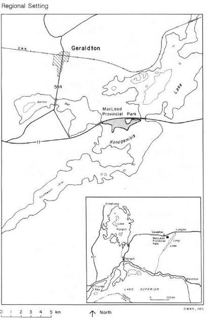
Enlarge Figure 1: Macleod Provincial Park Regional Setting
3. Vegetation management
Revegetation is required in certain parts of the park, especially in the old gravel pit area along Highway 11 and on several old roads, which are no longer in use. As well, poplar canker has been identified at several locations in the park. Some action will have to be taken to limit the spread and eliminate the resultant safety hazard.
The spruce budworm has also been discovered in the park. Although there are no large spruce or balsam stands, if certain areas or trees are identified as significant, some action may be required.
The vegetation management strategies to address these concerns are outlined in section 6.2.
4. Park development
Since 1980, the park has shown a declining level of use. This trend has in part been attributed to poor weather, however, visitor comments also indicate that the condition of existing facilities and the lack of certain amenities is contributing to this decline in use.
To reverse this trend, facility upgrading and redevelopment, an improved visitor services program, and enhanced marketing are proposed. The objective is to increase the number of return visitors, and those who will consider MacLeod Provincial Park as a vacation destination The details for these initiatives are contained in sections 4.0 and 11.2.
3.0 Park policies
The policy direction for MacLeod Provincial Park, contained in this management plan, is consistent with that provided in the "Ontario Provincial Parks: Planning and Management Policies" document as approved by the Provincial Cabinet in 1978.
3.1 Classification
MacLeod Provincial Park is classified as a recreation park. Recreation parks are areas that support a wide variety of outdoor recreation opportunities for large numbers of people in attractive surroundings.
3.2 Goal
The goal of Macleod Provincial Park is:
To provide a wide variety of outdoor recreation opportunities for local people, residents of Ontario and out-of-province visitors and to provide opportunities to appreciate the natural and cultural heritage of Ontario as represented in the park.
3.3 Objectives
3.3.1.Protection and heritage appreciation
To protect provincially significant elements of the natural and cultural landscape of Ontario and to provide opportunities for exploration and appreciation of the natural and cultural heritage of Ontario.
MacLeod Provincial Park does not contribute significantly to the representation of earth and life science features. It does contribute to the protection of historical resources. There are two identified archaeological sites and it will be an objective of this management plan to protect and enhance the contribution of these sites to a heritage appreciation program.
3.3.2.Recreation and tourism
To provide provincial park outdoor recreation opportunities ranging from high-intensity day-use to low-intensity wilderness experiences and to provide Ontario’s residents and out-of-province visitors with opportunities to discover and experience the distinctive regions of the Province.
This management plan contains strategies to meet this objective by:
- encouraging public use of the camping opportunities
- providing activities to increase the average length of stay
- ensuring that areas with potential for car-camping development remain available for development
- providing additional car-camping opportunities when the demand warrants
The potential annual supply of day-use opportunities in MacLeod Provincial Park is well in excess of the District target of 6000 opportunities per year by the year 2000.
The existing level of use is in the range of 3000 to 3500 opportunities annually. It is anticipated that day use activity will increase marginally from the existing level, in order to contribute to the District target.
The existing level of use of the campground during the May to September operating season is, on average, 11,000 camper nights per year, (1984 figure). The park presently has the capacity to provide 19,700 car-camping opportunities from 85 campsites, and has an estimated potential of 7,900 additional opportunities based on the development of 35 additional campsites. Therefore, MacLeod Provincial Park has the capacity to supply a total of 27,600 car-camping opportunities, if fully developed.
This figure represents the maximum contribution the park can make toward the achievement of the district car-camping target of 41,000 opportunities per year by the year 2000 MacLeod Provincial Park does not provide any backcountry travel opportunities.
4.0 Land Tenure and park boundary
4.1 Land Tenure
As illustrated in Figure 2, the land tenure situation in MacLeod Provincial Park is complex. The park consists of ten mining claims that were patented in the late 1930's. As well a small portion of the park area is covered by mining licence of occupation TB 20657.
Land acquisition to establish the park commenced in 1958. In that year the surface and mining rights for the land portion of one patented mining claim were purchased outright by the Crown. In 1959, an agreement was signed with Oklend Gold Mines Ltd. under which the surface rights for seven patented mining claims were transferred to the Crown. In 1961, the surface rights for two other patented mining claims were purchased from Consolidated Mosher. The area that had been acquired was put into regulation as a provincial park in 1963. In 1973, the land under water portion of the original claim obtained in 1958 was forfeited to the Crown. However, this parcel has not been incorporated in the park.
It is important to note that, in the sales agreement made with Oklend Gold Mines Ltd. commitments were made that:
- the land would be used as a provincial park
- if the land was used for purposes other than a park it would be re-transferred to Oklend
- Oklend would have full liberty to prospect and carry on mining operations
Figure 2: Macleod Provincial Park Land Tenure
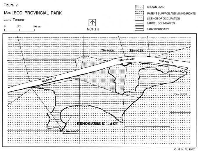
Enlarge Figure 2: Macleod Provincial Park Land Tenure
When Consolidated Mosher transferred the surface rights to the Crown they retained the mineral rights. Therefore, they also have the right to enter the park to prospect for minerals or to carry out mining operations on the two patented mining claims.
In the western portion of the lagoon, the Crown holds both the surface and mineral rights. The remainder of the area is covered by a mining licence of occupation for the land under the water. Under the mining licence of occupation, the Crown holds the surface rights to the land under the water while the mineral rights are held by Oklend Gold Mines Ltd. The lagoon is not presently part of the park.
With respect to licences of occupation, the Provincial Parks Act R.S.O. 1980 does allow for mining activity to be carried out in parks where the surface lands have been received by the Ministry, and the mines and minerals are not vested in the Crown.
However, where it is necessary to interfere with the surface rights to carry on mining operations, the district manager or park superintendent in charge of the provincial park may permit such interference as he or she considers necessary. Consequently this management plan outlines guidelines to assist the district manager or park superintendent in placing conditions on exploration activities which may occur. Conditions will be specific to the zones where there are licences of occupation. Section 6.1 provides specific guidelines pertaining to mineral resources management.
4.2 Park boundary
Proposed boundary changes have been considered during the planning process in order to solve existing and potential problems, ( see Figure 2). Upon consideration, two additions to MacLeod Provincial Park are proposed.
1. Land portions of mining claims TB-10720 and TB-10721
These parcels cover a total land area of one hectare south of the Highway 11 right-of-way, and are held by a private individual.
This property is important to the integrity of the park in order to control any development that may conflict with park values through visual impairment of aesthetics or interference with user enjoyment. It is proposed to acquire the surface rights only. To this end the property is on the acquisition list and purchase will be discussed with the owner.
2. MacLeod Lagoon
The lagoon is already an important feature of the park as it provides a quiet bay for canoeing and small craft boating. It is also an excellent place to view shorebirds and waterfowl. The water supply for the park is dependent upon the water quality and quantity in the lagoon. Incorporation of the lagoon in the park would protect these values and provide additional recreational and heritage appreciation opportunities.
In addition, each year there are requests about waterfowl hunting in the lagoon. Fortunately, to date there have been no problems. However, by including this area in the park, the future safety of park users would be assured since hunting would not be permitted.
In this case it is proposed to incorporate only the surface rights and water portion into the park and leave the mineral rights with the current holders. This approach would require no land acquisition to incorporate the nineteen, (19), hectare area of the lagoon into MacLeod Provincial Park.
5.0 Zoning
5.1 Introduction
As shown in Figure 3, MacLeod Provincial Park has been zoned in order to ensure that the land base in the park is put to the most appropriate use and that conflicting uses do not develop adjacent to each other. The park is divided into three types of zones:
- Access Zones which serve as staging areas where facilities support the use of zones with minimal or no development
- Development Zones which provide facilities and services for a wide range of day-use and camping activities; and
- Natural Environment Zones, which include aesthetic landscapes on which there is minimum development as required to support low intensity day-use recreation activities
5.2 Access zone
A-1: Kenogamisis Lake access point
This zone is intended to provide access to Kenogamisis Lake and the lagoon. The zone is 0.5 hectares in size and is defined by the boundaries of the existing clearing, the high water mark on Kenogamisis Lake and the road to the campground.
At some time in the future, a concrete boat launching ramp may be constructed. No other development will occur. While mineral exploration can occur in this zone, it is requested that exploration activity be planned so as not to interfere with the intended use of the site. Voluntary compliance with the activity guidelines found in section 6.1 is to be encouraged.
5.3 Development zones
D-1: Campground & day use area
The purpose of this zone is to provide day use and camping facilities for the visitors to the park. The zone is 37.0 hectares in size. In general, it consists of the built-up area of the park and is defined by the highwater mark on Kenogamisis Lake and the south and west side of the lagoon, the Highway ii right-of-way, the clearing at the park entrance, the road to the electrical sites and the group camping area.
Mining exploration is permitted in this zone except on mining claim TB-10780 which is held by the Crown. It is requested that exploration activity be planned so as not to interfere with visitors enjoyment of the park or disrupt the functioning of park facilities. Voluntary compliance with the activity guidelines found in section 6.1 is to be encouraged.
Vegetation management will be carried out in this zone in order to rehabilitate sites, ensure user safety, and provide an aesthetically pleasing environment.
There are two archaeological sites in this zone. These sites are a valuable park resource, and measures will be taken to protect the integrity of these locations. The management of the sites is discussed in section 6.4 of the plan.
The campgrounds and day-use areas located in this zone are developed to capacity and cannot be expanded. Services to camp users will be increased as demand is identified and funds are available. Re-development of roads and buildings will occur as required, in accordance with development priorities and based on available funding.
D-2: Campground expansion area
The purpose of this zone is to provide future camping opportunities when the demand warrants further development. The area of this zone is 4.0 hectares. It is generally defined by the existing park roads on the east, north and south, and by the limit of the flat, developable land on the west. A sufficient buffer zone will be left between this zone and the nature trail.
No development is to occur in this area that would hinder the intended future use. Before campground expansion occurs, a site plan will be prepared and approved. A comfort station for the users on the electrical sites will be permitted if it is deemed necessary.
All proposed developments will take into account the location of the Ministry of the Environment’s research plot. The research plot is used to monitor the long term changes in soil and vegetation due to acid precipitation. The Ministry of the Environment will be consulted should any development be proposed within 50 metres of this site.
Mineral exploration is a permitted use in this zone. It is requested that exploration activity be planned so as not to interfere with future development. Voluntary compliance with the activity guidelines found in section 6.1 is to be encouraged.
5.4 Natural environment zones
NE-1: Interpretive area
The purpose of this zone is to provide opportunities for the exploration and appreciation of the natural environment. The size of this zone is 20.0 hectares and it is generally defined as the area west of the D-2 zone.
An interpretive program for the park users will be developed for this area in conjunction with use of the nature trail. It will provide the park user with a self-guided, heritage-appreciation experience.
Additional trail development may occur if it is deemed significant to the interpretive program.
Mineral exploration is a permitted use in this zone. It is requested that exploration activity be planned to maintain the character of the zone. Voluntary compliance with the activity guidelines found in section 6.1 is to be encouraged.
NE-2: Highway Buffer
The purpose of this zone is to act as a buffer between Highway ii and the park. It has an area of 2.0 hectares and is defined as the land area between the lagoon, and Highway 11. It includes the parcel of land intended to be acquired for the park. Although it is not presently a part of the park, the intent is that it be included in this zone and managed accordingly if and when it is acquired.
No park development will occur in this zone. Vegetation will be managed to produce the maximum buffer between the park and the highway. Mineral exploration is permitted but should be carried out in such a way as to preserve the aesthetics and maintain the integrity of this area. Voluntary compliance with the activity guidelines found in section 6.1 is to be encouraged.
NE-3: MacLeod Lagoon
The purpose of this zone is to provide the park users with low-intensity recreation opportunities to appreciate the natural environment. The lagoon is 19 hectares in size and the area is defined by the highwater mark, the NE-2 zone boundary, and the Highway 11 right-of-way. The lagoon will be managed as a low-intensity recreation area, primarily for canoeists and swimmers. Boating guidelines, to promote user safety and enjoyment, are presented in section 8.0 of the plan.
6.0 Resource management
6.1 Mineral resource management
Given the historical record of park acquisition and the legal rights enjoyed by the Crown as steward of the surface rights, and the private holders of the mineral rights, certain accommodations have to be made. In the interests of integrated resource management, a cooperative approach to the shared use of the area for park management and mining purposes is advocated. The Ministry of Natural Resources will, through implementation of this park management plan, work to ensure that mineral exploration and mining is not pre-empted where it is legally permitted to occur.
Where it is shown to be in the public interest, this park management plan also provides for a reduction in the area where mining is permitted. This may be accomplished through negotiations to purchase the mineral rights outright or to exercise some control over mineral exploration activity.
The Ministry of Natural Resources will work through the Ministry of Government Services to negotiate with the mining claim holders for the first-holders for the first-right-of-refusal should the owners decide to sell the mineral rights.
Conversely, the plan also recognizes that a producing mine may present social and economic benefits that warrant the downgrading or complete rescindment of the park. To do this would require disposition of the surface rights by the Crown. This action would be evaluated by the Ministry of Natural Resources in accordance with the provisions set out in the Environmental Assessment Act, RSO 1980. Public consultation with interested and affected parties would be a part of any proposal to dispose of land now part of the park.
Until such time as the joint occupancy of the park is resolved, mineral exploration and mining is a permitted use in MacLeod Provincial Park. All proposed exploration operations should be presented to the Ministry of Natural Resources for review. The following guidelines are to be applied on a voluntary basis for holders of mineral rights on patented mining claims, and an obligatory basis for areas covered by licences of occupation:
- Exploration will be carried out on valid mining claims by registered owners only
- Walking and surface rock sampling may occur at any time with permission of the district manager or park superintendent
- All other activities should be carried out during the off season when the park is not operating
- No line cutting will occur in the par Lines may be marked with flagging tape
- No blasting or trenching should occur in the park
- No camps should be established in the park
- Wherever possible, drilling operations will be encouraged to locate on the lake ice, including the lagoon, in order to minimize the effect on the park
- in zone D-1 no drilling will occur on the archaeological sites
- in zone NE-i clearings for drill sites will be kept to a minimum and access to the site should be from the lake or the highway right-of-way
- in zone D-2 clearings for drill sites will be kept to a minimum and the MOE research site will be accorded a suitable buffer zone
- all drill sites will be restored to their original condition after the operation is completed
The district manager or park superintendent will use discretion in reviewing any other operations not listed above, bearing in mind, the park goal and objectives, the intent of the zoning, and the anticipated effects of the operation on park values and the use and enjoyment of the park.
A review procedure will be prepared that will outline the review process and provide more detailed measures to mitigate impacts and protect park values. A Fact Sheet containing the guidelines and an outline of the review procedure will be made available at the MNR district office and the Thunder Bay mining recording office for consideration by affected or interested parties.
Through consideration of the voluntary guidelines presented in the park management plan it is hoped that mining companies would work to protect park values and promote user safety and enjoyment of the park.
6.2 Vegetation management
All vegetation in MacLeod Provincial Park will be managed in order to ensure the safety of park users and protect the environmental integrity of the life science park values. No commercial harvesting of timber will occur in MacLeod Provincial Park.
In zones D-1 and D-2 the following may occur:
- ground spraying of specific trees for spruce budworm in order to preserve the aesthetics of a site
- cutting of trees infected with poplar canker in order to minimize its spread, and physical removal of danger trees, followed by replanting of the area with another native tree species
- replanting of the gravel pit area adjacent to Highway 11 with jack pine or some other suitable native tree species
- replanting of several unused roads in order to provide a long term solution to some of the access control problems
In zone NE-1:
- no spraying, cutting or planting will occur except as required to ensure public safety
In zone NE-2:
- spraying, cutting or planting may occur in order to maintain and maximize the buffering effect between Highway 11 and the rest of the park
6.3 Landform management
The sandy soils found in the park are sensitive to erosion in areas where vegetation has been removed and there is high use. Such erosion tends to degrade the recreational areas and constitute a public safety hazard. Zone D-1 has some landform management requirements along the road through the campground area where cut banks are being undermined. As well, along the lakeshore in the day-use area, erosion is creating gullies in the embankments. Landform management will be carried out in order to rehablitate these areas and to prevent erosion.
This work has begun and will continue as human resources and funds permit.
6.4 Wildlife management
Hunting and trapping will not be permitted in MacLeod Provincial Park. Wildlife management efforts will be directed as follows:
- nuisance animals will be removed if they present a public safety hazard
- all identified avian nesting sites will be protected from incompatible uses
6.5 Cultural resources
The entire park has never been subject to a detailed archaeological survey, however, two archaeological sites have been identified. These two sites have been examined by archaeologists from the Ministry of Citizenship and Culture, (MCC). One site has been producing early French Fur Trade artifacts making it important at least in a regional context. This site, adjacent to the beach, is located on a sandbar below lake level, and is slowly eroding away. The second site at the east end of the park is quite large relative to the occupied area of the campsite and is partially protected by 3-6 cm of soil. This site has not yielded as many artifacts.
Park staff will continue to make periodic surface collections from the site adjacent to the beach in order to salvage whatever material is possible. Should the water level drop sufficiently to expose the sandbar, MCC will be contacted so that their staff can conduct a thorough examination of the site.
Camping use will be permitted to continue at the other identified site since the soil covering offers some protection to the resources. The intent is to monitor the site each operating season to ensure no harm is occurring, and undertake an intensive survey of the site in the future.
Further management direction is as follows:
- subject to available funding, a more extensive survey of MacLeod Provincial Park will be carried out as a joint MNR/ MCC operation
- any new sites identified will be managed accordingly, relative to their significance and the threat to the resources from existing uses
- in consultation with the archaeologists from MCC the cultural resources will be included in the interpretive program for the park
7.0 Tourism services
The concession stand in the park will continue to operate as a permitted use. The Ministry of Natural Resources must approve the provision of any additional services over and above those now provided. Any further commercial developments, to be approved, must be consistent with park objectives.
8.0 Recreation management
Boating restrictions will be put in place in MacLeod Lagoon (zone NE 3) in order to provide a quiet place to appreciate the natural environment, and ensure the safety of all users.
The restrictions are as follows:
- the lagoon will be used by park visitors only
- waterskiing is not permitted
- motor boats are not to operate at excessive speeds
During the winter months, cross-country skiing and snowshoeing are permitted uses in the park. Snowmobiles are not permitted to operate in the park.
9.0 Visitor services
9.1 Information
Visitors to MacLeod Provincial Park will be provided with a basic level of information which describes the facilities and services available, and the rules which govern the park. At the present time the park leaflet meets this need. The leaflet will be updated as required. Information will also be provided on points of local interest and other provincial parks located to the east and west on Highways 11 and 17.
This approach recognizes that MacLeod Provincial Park is primarily a stopover for vacationers on their way to other destinations. The small size of the park, precludes the need to develop a more elaborate information dissemination system. However, additional information will be gathered for the interpretive program.
9.2 Interpretation
The interpretive program for MacLeod Provincial Park will focus on the cultural heritage of the park and local area. Of particular importance are the archaeological sites, and the trapping, mining, and logging history of the area. The natural features of the park, and their influence on history and development, will form an important part of the interpretive program. This will be accomplished through:
- the preparation of topical and trail brochures
- construction of interpretive displays
- improvements to the nature trail
This approach is in keeping with the objective to increase park usage by providing activities to keep visitors an extra day or two and to increase day use by local residents. In addition, public comments in the 1984 park users survey suggested that improvements in the interpretive program are required.
The use of MacLeod Provincial Park for outdoor education will be encouraged. The improved interpretive program will assist in this regard. In addition, park staff will make themselves available to conduct tours of the park and point out its special natural and cultural features. This will require that park staff familiarize themselves with this information in order to be able to answer questions and enhance the visitor’s educational experience.
9.3 Recreation
MacLeod Provincial Park will provide a variety of outdoor recreation opportunities. For the most part, these activities will be self-directed and unsupervised, including swimming, picnicking, fishing, canoeing, walking and relaxing. Organized recreational activities may be undertaken if they contribute to park objectives.
Use of the park by organized groups for the purpose of meeting and recreating in a natural setting will be encouraged.
10.0 Development
10.1 Introduction
Figure 4 outlines the location of existing park facilities. Redevelopment of existing park facilities will be considered, to satisfy user needs, provided that significant cost savings can be achieved. Improvement of park facilities to attract users and extend the average length of stay is a primary concern.
The recent decline in use of the campground car camping opportunities is a cause for concern. Poor weather may have been a factor, however, visitor comments also indicate that the condition of existing facilities and the lack of certain amenities is contributing to this decline in use.
To reverse this trend, upgrading and replacement of facilities is proposed. This development will be directed to increase the number of users who consider MacLeod Provincial Park as a destination park, and establish a park clientele who will make return visits to the park and stay longer.
Should this strategy be successful, it may be necessary at some future date, to develop more campsites. The D-2 development zone has been set aside for this purpose. The park presently provides 19,700 car-camping opportunities from its 85 campsites. The existing level of use is about 11,000 camper nights per year, (1984 figure). Should the level of use reach approximately 19,000 camper nights per year, development of new campsites should be considered.
The undeveloped potential of the park is estimated at 7,900 opportunities based on the development of 35 additional campsites. The actual scale of campsite development will be confirmed at the time expansion is deemed warranted. In the interim the area is to be protected from incompatible uses which would preclude campground expansion.
10.2 Development priorities
In order of priority, the following developments are scheduled or proposed to occur:
- replacement of hydro poles
- showers installed at the comfort station
- concrete boat launch ramp in the access zone
- beach change house improvements
- construction of interpretive facilities which may include additional trails, signs, and displays
- campsite development, including a new comfort station in zone D-2 (when demand warrants)
A small building may be appropriate to house archaeological and historical artifacts, photographs and other pertinent material. Additional campsite development will require the upgrading of the water system which is now operating at capacity.
These developments will occur in response to public demand, based on requirements to meet operating standards, and subject to funding becoming available. Site plans will have to be prepared and approved prior to proceeding with development.
11.0 Implementation
11.1 Park operations
The park will be operated according to the park operating plan for MacLeod Provincial Park. This plan is updated annually and a copy of the plan will be kept on open file at the Geraldton MNR District Office.
11.2 Marketing
The marketing objectives for MacLeod Provincial Park are to increase:
- day use, overnight camping, and use of the interpretive facilities by local individuals and groups
- the number of return visitors using the park as a stop-over or destination
- the number of first time users that select MacLeod as a stop-over or destination
These objectives will be accomplished by employing the following strategies:
- use local advertising, newsletters and media articles to alert local groups and individuals to the park opening dates, features of interest and services provided
- ensure that park staff practice good public relations so that visitors are enthusiastic about returning to the park as a destination or stop-over on subsequent trips to the area
- ensure that sufficient recreational and interpretive opportunities are available to encourage park visitors to extend their stay by several days or consider returning
- participate in the provincial parks publicity program to ensure that MacLeod Provincial Park is widely advertised as an available and attractive stopover destination
Upon completion of the North Central Region Marketing Strategy, an individual marketing strategy will be prepared for MacLeod Provincial Park. This strategy will be reviewed annually and revised as required.
11.3 Plan review
The MacLeod Provincial Park Management Plan will be reviewed as warranted over the 20 year period. As a minimum requirement, the plan will be reviewed ten years after approval.
Whether a review is conducted to examine the plan’s continuing relevance or to address an amendment, the prescribed public consultation requirements will be applied.
12.0 Public consultation summary
The release of the preliminary management plan for MacLeod Provincial Park presented the first formal opportunity for public comment on future park management. As well as draft policies and planning direction, it contained background information and alternative park zoning plans, for public consideration. In compiling the background information and drafting the preliminary management plan, discussions were held with affected and interested Government Ministries, the Municipality, and other groups and individuals.
Public notice of the release of the MacLeod Provincial Park Preliminary Management Plan was placed in 2 editions of the Geraldton Times Star, and the Thunder Bay Times-News and Chronicle-Journal.
A total of 26 preliminary management plans were mailed out and 6 were distributed at the District Office. No written comments were received.
A display was set up in the District Office between February 18 and March 27, 1986. Six members of the public viewed the display. Verbal comments received were as follows:
- 1 - in favour of Option 2
- 1 - concerned that Macleod Provincial Park would be contracted out for private operation
- 2 - wanted showers
- 1 - wanted laundry facilities
- 1 - property owner whose parcel is identified for acquisition was concerned about wording of plan statement
The final Management Plan for Macleod Provincial Park has Option 2 selected as the preferred zoning configuration. Contracting out of the entire park operation is not an option, however, the private concession stand will continue to operate as a permitted use. The existing comfort station has laundry facilities and showers are going to be installed. The matter of property acquisition in question, has also been addressed in the final plan.
References
Geraldton District Land Use Guidelines, (Unpublished): Ontario Ministry of Natural Resources; 1983.
Macleod Provincial Park Leaflet, Ministry of Natural Resources, Geraldton District.
Ontario Ministry Of Natural Resources; Geraldton District Office files; 1985.
Ontario Ministry Of Natural Resources; North Central Regional Office Files, Thunder Bay; 1985.
Ontario Provincial Parks Planning And Management Policies: Ministry of Natural Resources: 1978.
Provincial Parks Act, Revised Statutes of Ontario, 1980.