Magnetawan River Provincial Park Management Statement
This document provides policy direction for the protection, development and management of Magnetawan River Provincial Park and its resources.
Interim Management Statement
March 1, 2004
The Magnetawan River Provincial Park Interim Management Statement provides direction for the custodial management of Magnetawan River Provincial Park until such time as a Park Management Plan may be prepared. An Interim Management Statement, by design, is primarily an internal document intended to provide short-term guidance for Ontario Parks' managers and staff. The Interim Management Statement will govern all activities occurring within the park and focus on custodial management required to protect park values and ensure public health and safety.
Questions or requests for additional copies of this document should be directed to:
Ontario Parks, Central Zone
RR#3, 451 Arrowhead Park Road
Huntsville, ON
P1H 2J4
I am pleased to approve the Magnetawan River Provincial Park Interim Management Statement.
Brian Pfrimmer
Manager
Central Zone
Ontario Parks
Background information
| Name | Magnetawan River Provincial Park |
|---|---|
| Classification | Waterway |
| Ecoregion / ecodistrict | 5E / 5E-7 |
| OMNR administrative region / district | Southern Region / Parry Sound District |
| Total area (ha) | 3,424 |
| Regulation date | June 28, 2003 |
Inventories
| Survey level | Earth science | Life science | Cultural | Recreational | Other |
|---|---|---|---|---|---|
| Check Sheets / Inventories | 2001 | ||||
| Reconnaissance | 2003 | ||||
| Detailed | 2002 | 2002 | 2002 |
| Earth science representation | Magnetawan River Provincial Park is situated within the Britt Domain, Algonquin Terrane, of the Central Gneiss Belt of the Proterozoic Grenville Province. It occupies segments of several southeast-northwest and northeast-southwest bedrock lineaments. The dominant rock types include deformed intermediate-mafic gneisses and metaquartzite and later pegmatites. The geology of the Park has regional significance. |
|---|---|
| Life science representation | Recent surveys have identified 11 forest Ecosite Types, 8 forest understorey Vegetation Types and at least 287 vascular plant species. Most communities are in excellent condition. Eleven species of herptiles, 84 species of birds and at least 16 species of mammals were recorded within the park. |
| Cultural resources representation | A reconnaissance inventory revealed a high potential for the presence of both pre-and post-contact sites of archaeological significance. The park also shows evidence of logging, which occurred between 1850 and the 1920s and had a major influence on settlement patterns in the region. Hunting, trapping and fishing occurred historically among First Nations and Europeans. Today, the Magnetawan River supports recreation and tourism. |
| Recreational opportunities | Canoeing, Camping, Kayaking, Swimming, Hunting, Fishing, Nature Appreciation |
1.0 Introduction
On July 16, 1999, the Ontario Government released the Ontario’s Living Legacy Land Use Strategy to guide the planning and management of Crown lands in central and parts of northern Ontario. A major component of the Land Use Strategy was a government commitment to protect 12 percent of Ontario’s Crown lands and waters within the planning area of the strategy. Magnetawan River Provincial Park is part of this significant expansion of Ontario’s protected areas system.
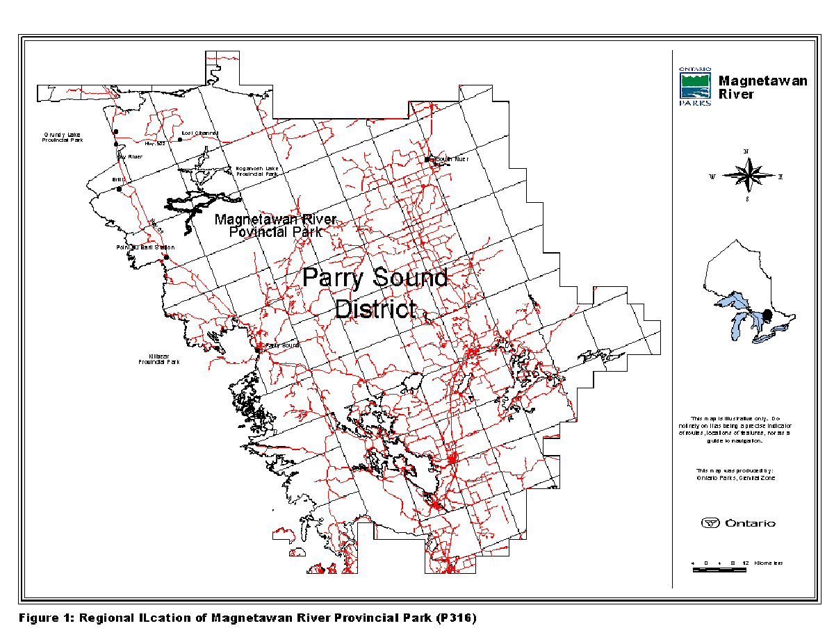
Magnetawan River Provincial Park is located in the Parry Sound District, within Brown, Wallbridge, Harrison and Burton Townships (Figures 1 and 2). The northern and western parts of the park are in unincorporated territory, while the southwest and eastern sections are within the municipally incorporated Township of the Archipelago and Municipality of Whitestone respectively. The park spans Ecodistrict 5E-7.
Magnetawan River Provincial Park protects an important ecological link between Noganosh Lake Provincial Park, Island Lake Forest and Barrens Conservation Reserve, Naiscoot Forest Conservation Reserve, and Wahwashkesh – Naiscoot Conservation Reserve. Most of the lands surrounding the park are within the Parry Sound Interior Remote Access Enhanced Management Area.
A small number of provincially rare species of plants, including several plants with Atlantic Coastal Plain affinities, and one provincially rare species of reptile were identified in the most recent survey of the park.
The region in which Magnetawan River Provincial Park is situated is also known to be of historical significance to both First Nations and European Settlers. The river has been an important travel route, and at various times supported hunting, fishing, trapping, trade and logging. Today, the park provides excellent recreational opportunities for many activities, including canoeing, hunting, fishing and swimming.
2.0 Classification
Magnetawan River Provincial Park is classified as a Waterway class provincial park in recognition of its outstanding natural and human heritage values. The park protects an important historical and recreational water route that can provide high quality recreational and educational experiences.
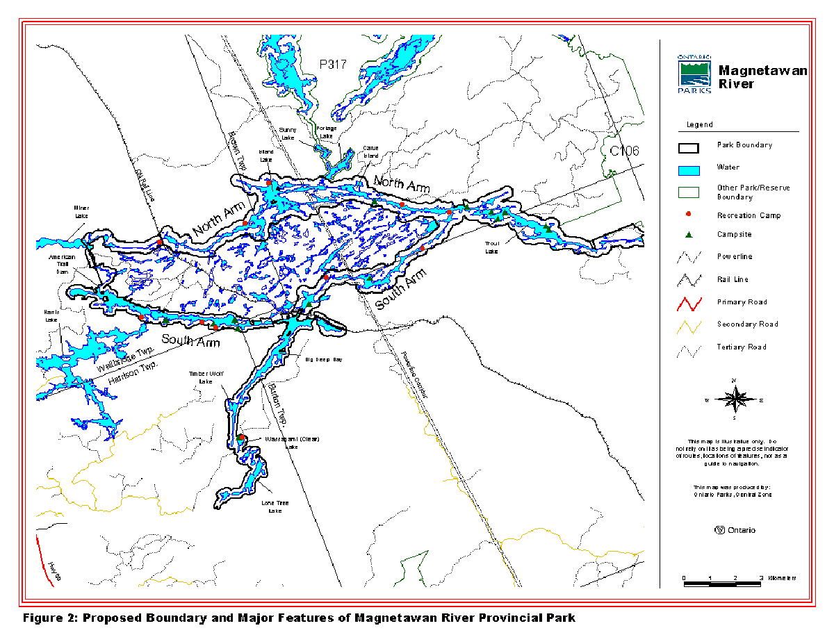
3.0 Boundary
The eastern boundary of Magnetawan River Provincial Park abuts Island Lake Forest and Barrens Conservation Reserve in the northeast corner of Burton Township (Figure 2). The park boundary extends west along the watercourse of both the North and South branches of the Magnetawan River, and includes the riverbed, Crown islands and shore lands up to 200 metres wide on either side of the water’s edge. Where the park adjoins private lands, the boundary extends to the water’s edge.
Following the South Arm, the boundary dips into the northeast corner of Harrison Township, encompassing Big Deep Bay, Timber Wolf Lake and Lone Tree Lake before continuing west along the South branch of the Magnetawan to the western boundary at the American Trail Dam and Eastern end of Miner Lake in Wallbridge Township. The boundary in this section of the park is generally set back 120 metres from the water’s edge.
Leaving Trout Lake the park boundary also follows the North branch of the Magnetawan through Brown Township and around Island Lake, before joining with the South branch at the American Trail Dam.
The park was regulated on June 28, 2003 under Ontario Regulation No. 238/03 (see Appendix A).
4.0 Interim management guidelines
Unless otherwise noted, the management policies for Waterway class parks, presented in Ontario Provincial Parks: Planning and Management Policies (1992) will apply to the site. Management of the park will also consider the land use direction outlined in the Ontario’s Living Legacy Land Use Strategy, including its provisions to respect the existing protective and restricted access measures defined for the Magnetawan region in the MNR Parry Sound District Land Use Guidelines (1983).
While the approved Interim Management Statement is in effect, Ontario Parks may pursue opportunities for partnerships involving other agencies and groups. Park management and stewardship will be contingent upon availability of funding and unforeseeable changes in priorities or policy. All management and stewardship activities will conform to the Environmental Assessment Act, Provincial Parks Act and other pertinent legislation.
Figure 1: Regional/Location of Magnetawan River Provincial Park (P316)
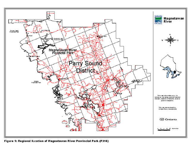
Enlarge Figure 1: Regional/Location of Magnetawan River Provincial Park (P316)
Figure 2: Proposed Boundary and Major Features of Magnetawan River Provincial Park
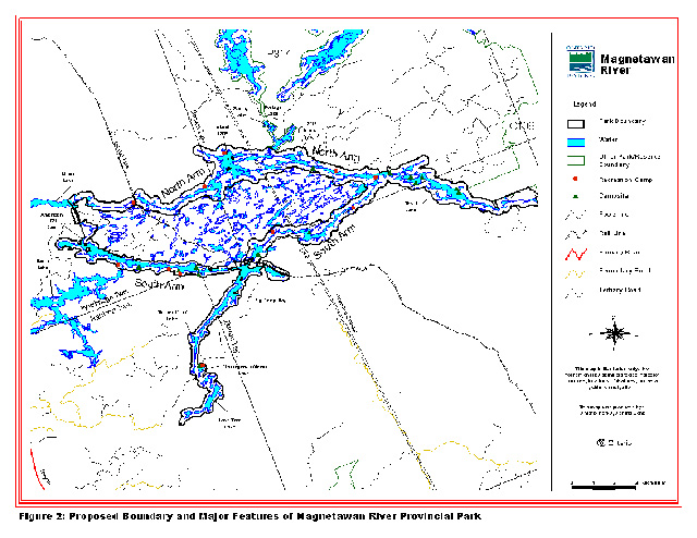
Enlarge Figure 2: Proposed Boundary and Major Features of Magnetawan River Provincial Park
4.1 Natural resource stewardship
The protection of provincially significant, special or representative life and earth science features will be a high priority for Magnetawan River Provincial Park.
Management of the area will allow natural processes to continue to shape the ecology of the park’s aquatic and terrestrial environments wherever possible. A resource stewardship plan may be considered if more detailed planning and management direction is required for resource or heritage values of particular concern.
All fires will be suppressed due to the adjacent private land holdings. Fire management through prescribed burning will not be considered at this time.
To the extent possible, water levels will be allowed to fluctuate naturally to promote the long-term viability of the Atlantic Coastal Plain communities found in Magnetawan River Provincial Park.
The monitoring of flora and fauna populations and improvement of inventories will be encouraged.
4.2 Cultural resources
Although the Magnetawan region is known to be historically important, the archaeology of the area is poorly understood, and little research has been conducted within the park specifically. A reconnaissance cultural resources inventory found that there remains significant potential for the existence of sites of importance within the park for both the pre-and post-contact periods. (Carscallen, 2003).
Given the limited understanding of the resources present, and the potential for important sites, further study of the park will be encouraged. Sites identified for physical improvements in future management planning processes will be inspected for the presence of cultural resources prior to development.
4.3 Recreational activities
Canoeing, boating, and other low-impact recreational activities associated with it, such as swimming, hiking and general nature-appreciation will be permitted in Magnetawan River Provincial Park.
The continued use of existing campsites within the park boundary will be permitted on an interim basis until a management plan is prepared. Sites may be closed if it is determined that use is causing a negative impact on the environment or protection objectives of the park. Alternate sites may be provided should the closure of an existing site(s) be required but, overall expansion of camping opportunities will only be considered through a full management planning process.
Existing authorized trails and portages can continue to be used. A trail assessment may be completed to review the existing trail structure and to provide appropriate recommendations.
As prescribed in Ontario’s Living Legacy Land Use Strategy, sport hunting and commercial trapping, except in nature reserve zones, and angling are permitted to continue within park boundaries.
Through the management planning process, further management prescriptions can be made to minimize user conflicts and maximize user enjoyment. In the interim, any recreational activity found to have a negative impact on the protection objectives of Magnetawan River Provincial Park may be restricted or have appropriate actions taken to minimize effects.
In keeping with the restricted access provisions defined for the region in the MNR Parry Sound District Land Use Guidelines (1983) access to the park will generally be limited to traditional means, namely boat-in, fly-in (Section 4.6), walk-in and ATV/snowmobile use along existing authorized trails. There are no public access roads to the park.
4.4 Land tenure
The park is comprised of only the Crown land, riverbed and Crown Islands along the watercourse described in Section 3.0. There are privately owned lands encompassed within the greater park boundary.
There are eleven Crown land recreation camps located within the park, seven under Land Use Permit (LUP) and four under License of Occupation (LO). There are also several recreation camps, one commercial outpost camp and numerous cottages located on private lands immediately adjacent to the park and whose activities may need to be considered in future management planning processes.
Existing recreation camps within park boundaries operating under an authorized LUP or LO will be permitted to continue and may be eligible for enhanced tenure, but not purchase of land. Unauthorized occupations of park lands or waters will be managed with approved policy, and will be removed at the owner’s expense whenever possible.
New Crown land dispositions for the private use of individuals are generally not permitted. However, small parcels of Crown land that support the subsistence needs of existing private landowners (e.g. reconstruction of a septic system) may be considered for sale on a case-by-case basis provided that park values are not adversely affected.
New dispositions for commercial tourism uses can be considered through a management planning process where consistent with existing policy. No new licenses or permits will be issued for commercial trapping, fishing, baitfish or wild rice harvesting activities.
An existing 120 m wide Hydro One power transmission corridor, authorized by a LUP, crosses the park and will be permitted to continue, including necessary access for maintenance. The CN rail line that crosses the river is under a right-of-way and has been excluded from the park boundary.
4.5 Existing and proposed development
There are numerous campsites, trails and portages found in the park. A portage trail, locally known as the American Dam trail, circumvents the dam and rapids in the west end of the park on abutting private land.
A number of Ontario Federation of Snowmobile Clubs (OFSC) trails exist in the region surrounding the park. An OFSC trail passes through the park in the vicinity of Canal Rapids, east of Trout Lake, where there is a permanent bridge crossing. There is also a fairly extensive network of old logging roads and other trails located between the North and South branches of the Magnetawan River and to the west of the park, between Highway 69 and Timber Wolf Lake. All resource access roads in the area are closed to public use. Authorized existing and future roads crossing the park have been identified by the Ontario Forest Accord Advisory Board.
A hydro corridor bisects the park at Island Lake and to the northeast of Big Deep Bay. An access trail follows the corridor, portions of which are open to public travel by ATV in Brown Township. A private road crosses the river between Miner Lake and the American Trail Dam which is subject to continued use for forest management purposes according to a December 1999 agreement. A resource access road also passes through the park between Timber Wolf and Lone Tree Lakes. These authorized pre-existing roads can continue to be used for access purposes.
There is no proposed development for Magnetawan River Provincial Park at this time. However, improved access points may be considered. A full management planning process will be completed prior to any other future development. Signage may be established in the interim as required.
4.6 Commercial activities
Commercial timber harvesting, hydro development, and mineral exploration and mining are not permitted in Magnetawan River Provincial Park. Existing authorized commercial activities relating to trapping, baitfish or wild rice harvesting may continue where the activity has been licensed or permitted since January 1, 1992. New operations will not be permitted.
There are parts of seven registered trap lines within the park. These will be permitted to continue indefinitely. New commercial fur harvesting operations, including trap line cabins and trails will not be permitted. A portion of one Bear Management Area (BMA PS4901) intersects with the park, extending from Miner Lake to the South branch. This BMA can continue to exist indefinitely.
Several commercial outfitters operate in the Magnetawan region, including one company that has a fly-in camp on Portage Lake. Although the camp is not within park boundaries, a number of their boats are cached in the park immediately to the south on Island Lake and are used to access various fishing spots both inside and outside the park. Existing authorized facilities will be allowed to continue subject to management prescriptions. Through management planning these may be eligible for enhanced tenure, but not purchase of land. New tourism facilities may be considered through a management planning process where consistent with existing policy and protection objectives.
Uses in association with fly-in operations will conform to park policies and provincial statutes. At present, aircraft are permitted by regulation to land in only a limited number of provincial parks specified under the Provincial Parks Act. Although Magnetawan River Provincial Park is not one of the parks identified in the regulations, in keeping with the intent of the Ontario’s Living Legacy Land Use Strategy recreational uses that existed at the time of the park’s designation will be permitted to continue. Traditional float plane access will be permitted to continue as a ‘non-conforming' use until such time as landing regulations may be amended, suitable alternate means of access can be provided or uses disappear naturally. Aircraft landings will be reviewed when a park management plan is prepared.
4.7 Aboriginal interests
Through discussions with the Magnetawan First Nation it has been determined that Magnetawan River Provincial Park is not subject to any native land claims by the Magnetawan at this time. Henvey Inlet and Shawanaga First Nations are also in the Magnetawan region and will be consulted where appropriate in future management planning processes.
Management of the park will not impede the ability of First Nation members to exercise their aboriginal and treaty rights, nor will it interfere with the settlement of any future land claims that may arise.
4.8 Client services
Natural Heritage Education programs will not be provided in the interim but will be considered through the management planning process. Basic information on the park may be provided through Ontario Parks' printed media, web site and on-site signage.
4.9 Research
Specific research by universities and other qualified applicants will be permitted. Prior written permission to conduct research is required, and all applications will be evaluated according to Ontario Parks' policies and the priorities set under Ontario Parks' Research and Information Strategy (1997). All research will be non-intrusive in order to safeguard protection objectives.
Research dealing with all aspects of scientific study, inventory or surveys of flora, fauna, ecological, cultural, economic and recreational resources and processes will be encouraged. Subject to budgetary considerations, Ontario Parks may elect to conduct or solicit research on any of the above areas of interest.
4.10 Marketing
A marketing strategy is not a priority for the park. One of the park’s valued characteristics is its relatively wild, remote and unspoiled setting. Actively promoting the park may adversely affect these qualities. Any future marketing initiatives will be developed and approved through a management plan.
5.0 References
Carscallen, C (2003). Stage 1 Cultural Heritage Inventory: Magnetawan River and Noganosh Lake Provincial Parks, AFBY Archaeological & Heritage Consultants, March 2003.
Davidson, R.J (1997). A Research and Information Strategy, Part One: Setting Priorities, Planning and Research Section, Ontario Park.
Frey, E.D., D. Duba (2002). P316 Magnetawan River Provincial Park Earth Science Checksheet, Ontario Parks, Central Zone.
Korol, J. Burke (2002). A Detailed Life Science Inventory of Magnetawan River Provincial Park, Ontario Parks, Central Zone.
Kretschmar, Ulrich (2002). Earth Science Inventory Report for Dalton Digby Wildlands Provincial Park, Magnetawan River Provincial Park, Noganosh Lake Provincial Park, Ontario Parks, Central Zone, 2002.
Marzinotto, Erika (2002). Magnetawan River Provincial Park (P316) Recreation Resource Inventory Report, Ontario Parks, Central Zone.
Ontario Ministry of Natural Resources (1999). Ontario’s Living Legacy Land Use Strategy, Queen’s Printer for Ontario.
Ontario Ministry of Natural Resources (1992). Ontario Provincial Parks Planning and Management Policies, 1992 Update, Parks and Natural Heritage Policy Branch.
Ontario Ministry of Natural Resources (1994). Park Policy, Procedure and Bulletin. "PM 11.02.01, Preparation of Interim Management Statements" Provincial Park Operations Branch.
Ontario Ministry of Natural Resources. Proposed Boundary Map, OLL Site P316, Magnetawan River Provincial Park, Parry Sound District GIS, July 16, 2002.
Ontario Ministry of Natural Resources (1983). Parry Sound District Land Use Guidelines.
Appendix A
Provincial Park and Conservation Reserve ID and Regulation Information
| Provincial Park / Conservation Reserve | Ontario’s Living Legacy Site # | Crown Land Use Atlas ID | Regulation Date | Regulation # |
|---|---|---|---|---|
| Magnetawan River Provincial Park | P316 | P316 | June 28, 2003 | 238/03 |
| Noganosh Lake Provincial Park | P317 | P317 | June 28, 2003 | 238/03 |
| Island Lake Forest and Barrens Conservation Reserve | C106 | C106 | August 10, 2000 | 461/00 |
| Naiscoot Forest Conservation Reserve | C116 | C116 | June 28, 2003 | 237/03 |
| Wahwashkesh – Naiscoot Conservation Reserve | C326 | C326 | June 28, 2003 | 237/03 |
| Parry Sound Interior Enhanced Management Area | E104A | E104A | N/A | N/A |