Management guidelines for forestry and resource-based tourism
Describes a range of practices, tools and techniques that should be considered when developing forest management prescriptions to protect resource-based tourism values during forestry operations.
Acknowledgements
Management Guidelines for Forestry and Resource-based Tourism were prepared during 1998 -2001. A working group was established to assist the Ministry of Natural Resources with the preparation of these Guidelines.
The Tourism Guideline Working Group was comprised of:
Jim Antler – Northern Ontario Tourist Outfitters, North Bay
Dave Barker – Ministry of Natural Resources, Field Services Division, Geraldton
Heather Barns – Ministry of Natural Resources, Field Services Division, Sauilt Ste Marie
Sergio Buonocore – Ministry of Tourism, Culture and Recreation, Thunder Bay
Paul Glassford – Ministry of Natural Resources, Land Use Coordination, Sault Ste Marie
Rick Groves – Tembec, Timmins
Jim Grayston Northern Ontario Tourist Outfitters, North Bay
Stephen Harvey – Ministry of Natural Resources, Forests Division, Sault Ste. Marie
Bruce Hyer – Northern Ontario Tourist Outfitters, Thunder Bay
Paul Jewiss – Abitibi Consolidated, Fort Frances
Mike Maxfield – Bowater, Thunder Bay
Betty McGie – Northern Ontario Tourist Outfitters, Wawa
John McLaren – Mackenzie Forest Products, Sioux Lookout
Gerry Webber – Ministry of Tourism, Culture and Recreation, Sudbury
Karen Wianecki – Ministry of Natural Resources, Forests Division Toronto
Many other people in the tourist and forest industries and government provided assistance in the development of these Guidelines. Special thanks goes out to those who took time from their daily jobs to show off “their part” of the forest including, Joe Johnson MNR Parry Sound, Larry Rosebrugh Algonquin Forestry Authority, Marg Watson Sudbury Aviation, Shane Looby Shooting Star Camps, Harry Pearce Domtar, Darren Tegal Domtar, Mark Jones Cochrane Air, Gord King Norbord Industries, Roy Bennett Kenda Wilderness Lodge, Dick Harlock Gogama Air Outfitters, Roger Mulligan Goodbush Forestry Services.
The assistance and input of the Provincial Forest Technical Committee is also gratefully acknowledged.
Thanks to Nancy Houle and Richard Raper of MNR Forest Management Planning Section and Jim Steele MNR Scienc’se and Information Branch for their patience and assistance.
Executive summary
Management Guidelines for Forestry and Resource-based Tourism are to be used in the development of forest management plans for those portions of the forest used for forestry and resource-based tourism. The Guidelines may also be useful during the development of Resource Stewardship Agreements. Those features of the forest used by the tourist industry are described in the Guidelines in general terms. Measures which may be taken to assist with specific identification of resource-based tourism values are outlined. The resource-based tourism industry itself is divided into three types: drive in, semi-remote and remote. One of the most challenging aspects of managing the interface between remote tourism and forestry is the planning of roads and their use. The forest industry requires roads to harvest, renew and, maintain the forest, while segments of the tourist industry need some areas which are “functionally roadless.” The need to provide the resource-based tourism industry with a “reasonably similar level of remoteness” is recognised in the Tourism and Forestry Industry Memorandum of Understanding approved by the Ontario government in 2001. All resource based tourism business depends in part on a visually forested landscape and a forest that is free from unwanted or disturbing noise. Forest management planners must consider the needs of the tourist industry when developing plans; however, they must also consider a wide range of environmental needs. Both tourism and environmental needs vary by forest type and site. A further challenge for forest management planners is the need to consider the interests of other stakeholders such as anglers and hunters. The decision to apply a specific technique to protect a tourism value is not a simple decision.
When the desired degree of remoteness in the forest is determined and other needs of the resource-based tourism industry established, the task of selecting a specific forestry tool or technique to address the needs of the resource-based tourism industry follows. Management Guidelines for Forestry and Resource-based Tourism describes a range of practices, tools and, techniques that should be considered when developing forest management prescriptions to protect resource-based tourism values. The information provided is based on operational experience. New and creative techniques, which may evolve over time, are encouraged as long as they do not contravene existing legislation. In practice, a combination of techniques usually produces the intended result (e.g. sign erected and culvert removed.) The information is organised under the headings: Access Management, Visual Aesthetics/Views, Noise Control and, Planning.
These Guidelines are intended for use by both forest management planners and owners/operators of resource-based tourism businesses. To ensure that readers are able to make best use of these Guidelines extra effort has been taken to explain how these Guidelines may be used in conjunction with the forest management plan development process. A number of “Tips” are contained in the Guidelines. “Tips” are not presented as “direction;” rather, the team which prepared the Guidelines felt there was merit to provide information to the user which might be used in any number of ways to assist with managing the forestry/tourism interface.
To ensure the continued effectiveness of forest management plans forest management guidelines should be evaluated. Resource-based tourism values and the methods used to protect these values are most often determined through discussions and negotiations between the resource-based tourism industry and forest management planner. Tourism values are quite different than other values that are the subject of forest management planning guidelines. Those features of the forest important to the tourist industry are not readily inventoried and are not supported by strong science. In fact many of the values used by the tourist industry are business specific; that is to say what may be important to one tourism business may be of relatively little importance to another. The means, then, of determining the effectiveness of these Guidelines must consider the effectiveness and efficiency of negotiations with the understanding that neither party to these negotiations may be entirely happy with the negotiated outcome but at the least they have what they require to pursue their business interest.
1.0 Introduction
These Guidelines are intended to assist with planning forestry operations in those parts of Ontario’s forest being used for both forestry and tourism. The “Guidelines” will be of interest to members of forest management planning teams who must prepare forest management plans every five years; they will also be of interest to the tourist industry. The tourist industry may find the useful information in the Guidelines when participating in forest management planning; opportunities to participate in planning are provided through the forest management planning process and, through the newly created opportunity to negotiate Resource Stewardship Agreements.
Information in this Guide:
- Introduces the reader to forest management planning.
- Defines the general planning needs of the tourist and forest industries.
- Provides practical advice for those involved in planning forestry operations in areas used by the tourist industry.
- Describes various tools and techniques for protecting resource-based tourism values.
- Discusses the evaluation of the Guidelines’ effectiveness.
These Guidelines are one source of expert information. Readers are encouraged to use other sources of information, especially that which can come from the individual experience of those negotiating Resource Stewardship Agreements and developing forest management plans.
1.1 Background
Public forests in Ontario are managed to produce a variety of benefits. The goal of forest management is to ensure the long-term health of forest ecosystems for the benefit of local and global environments, while enabling present and future generations to meet their social and material needs.
All forestry operations occurring within Ontario’s public forests are directed by a forest management plan. The forest management plan must provide for the sustainability of the forest and have regard to the plant life, animal life, water, soil, air, social and economic values. Forest management plans are produced for each forest management unit in Ontario; there are more than 50 management units. Each forest management plan must consider the needs of a diverse range of forest users including those of the resource-based tourism industry. The process for developing the plans provides various opportunities for public involvement.
Those responsible for preparing forest management plans must consult a wide range of planning manuals and guidelines including these Management Guidelines for Forestry and Resource-based Tourism. Timber Management Guidelines for the Protection of Tourism Values were first produced and distributed in 1987. Much has changed since that time including:
- A new legislative framework: the Crown Forest Sustainability Act (CFSA) 1994,
- A new land use strategy: Ontario’s Living Legacy (1999)
- Ontario’s Forest Accord: which enabled the creation of an extensive parks and protected areas system while also considering the needs of the forest industry.
- A Resource-based Tourism Policy (1997) which promotes and encourages the development of Ontario’s resource-based tourism industry in an ecologically and economically sustainable manner,
- The Tourism and Forestry Industry Memorandum of Understanding (2001) which sets out a process for negotiating local resource stewardship agreements.
These changes and other business and technologyrelated changes have resulted in a different approach to forest management on the ground. One of the significant changes in the approach to forest management planning has been the willingness of both the resource-based tourism and forest industries to search for ways to address each others’ needs while working in the same forest. These guidelines summarise those management options and practices to be considered when developing operational prescriptions in forest management plans intended to address resource-based tourism interests or values. The guidelines can serve as a common set of information for both the tourist and forest industries as they work together to formulate plans for working in the same forest.
Nothing in these guidelines shall prejudice or affect in any way the treaty and aboriginal rights of aboriginal people in Ontario.
1.2 Legislative framework
Forest management on crown land is the responsibility of the Minister of Natural Resources through the CFSA. The Class Environmental Assessment for Timber Management on Crown Lands in Ontario was approved in 1994. Both of these pieces of legislation govern how forest management takes place on Crown land. The CFSA provides for the sustainability of crown forests and in accordance with that objective, to manage crown forests to meet social, economic and environmental needs of present and future generations.
Under the CFSA there are four manuals, which further explain how forest management is to take place. One of these is the Forest Management Planning Manual (FMPM), 1996 which outlines the process and gives the format that must be followed in order for a forest management plan to be prepared and approved. These plans are prepared for every forest management unit where forestry operations are to take place; they are prepared every five years and consider the needs of the forest for the next 20 years.
Another manual, the Forest Operations and Silviculture Manual (1995) requires that these guidelines – Management Guidelines for Forestry and Resource based Tourism 2001 as well as many others for other forest values, be considered during the preparation and implementation of forest management plans.
The class Environmental Assessment for Timber Management on Crown Lands in Ontario was approved in 1994 with the condition that Guidelines and other implementation manuals be reviewed and revised as required.
The other two manuals are the Scaling Manual and the Forest Information Manual.
All forestry operations, which are planned to address resource-based tourism values, must follow the legal direction set out in the CFSA.
Licensing of resource-based tourism establishments is the responsibility of the Minister of Tourism through the Tourism Act and Regulation 1037. This legislation provides the legal basis for which resource-based tourism businesses are eligible a resource stewardship agreement (RSA).
1.2.1 Application of the guidelines
These guidelines are intended to provide assistance and direction to resource-based tourism and forest industry interests when they are involved in forest management planning or the development, implementation, and maintenance of a RSA. Ontario’s Living Legacy, the Resource-Based Tourism Policy and the Tourism and Forestry Industry Memorandum of Understanding (MOU), and its associated Guide to resource Stewardship Agreements, are important documents for consideration when planning for forestry and resource-based tourism.
The guidelines may be considered when writing resource stewardship agreements and must be considered when writing forest management plans when the decision to conduct forest management operations may affect a resource-based tourism industry’s operations. The guidelines contain a variety of techniques and best practices that will help to operationalize forestry in a fashion which addresses the tourist industries needs in the forest. These, used alone or, in any combination, can contribute to the tourists’ perception of wilderness and remoteness. While, the guidelines, alone, cannot deliver remoteness and wilderness since these are in part, perceptually based values, which vary from one individual to another, they can assist in maintaining remoteness.
These guidelines and, forest management plans, take direction from Ontario’s Living Legacy and other land use planning documents. Land use planning determines where forest management can take place; forest management planning, then, directs how forestry will take place on lands selected for this purpose.
These guidelines do not cover every possible technique or practice nor do they consider every situation. Indeed, it is understood that the forest that supports the tourist industry varies considerably across the province, as do the needs of individual tourist businesses. It is also understood that, unlike values addressed in other forest management guidelines such as moose or osprey, the tourist industry is best able to speak for itself and to identify its needs on a case-by-case basis. Management Guidelines for Forestry and Resource-based Tourism do not provide the answer for addressing all concerns in all situations, but they are a source of expert and objective advice.
During preparation of a forest management plan, it is necessary to document how decisions are made. This applies to all sections of the FMP, including the area of concern (AOC) prescriptions and analysis of access alternatives.
At the option of the parties involved, it may be useful to include all, or part, or a summary, of an RSA as an appendix to an FMP
In all cases where an RSA has influenced the development of an AOC or the selection of an access alternative, the FMP will explicitly reference the RSA as a source of direction and as rationale for the selected prescription/alternative.
The FMP will expressly state that the terms of any RSA do not bind or limit the Minister’s right to make land use decisions for crown land in Ontario.
1.2.2 Guideline development process
These guidelines were written as a co-operative effort among the resource-based tourism and forest industries and the Ministries of Natural Resources and Tourism. The group considered the information that came out of the Tourism and Forestry Industry Memorandum of Understanding development process.
1.3 The resource-based tourism industry
1.3.1 Resource-based tourism industry resource values
The key to a successful resource-based tourism industry is one that provides those experiences that match visitors’ expectations. The Memorandum of Understanding (MOU) signed between the forest and resource-based tourism industries recognizes the importance of:
- Natural aesthetics;
- Remoteness, including maintenance of traditional means of access;
- Maintenance of the perception of wilderness, including minimization of noise;
- Sustainability and enhancement of fish, game and wilderness opportunities necessary for tourism operations; and
- Maintenance of the perception of Ontario as a world class wilderness tourism destination.
The MOU also recognizes that there are elements that are critical for the success and viability of the forest industry:
- Minimize the cost of wood delivered to the mill;
- No long term reduction in the supply of fibre and timber;
- Security and accessibility of fibre and timber supply;
- Sustainability of the forest resource for future generations;
- Protection of other forest values; and
- Management of the forest resource in accordance with legislative and policy requirements governing forest management planning in Ontario.
- Sustainability and enhancement of fibre supply, timber supply and forestry opportunities necessary for forestry industry viability.
In addition, the MOU refers to ‘functionally roadless’ and ‘reasonably similar level of remoteness’. They may be defined as follows:
Functionally roadless
Functionally roadless areas are areas where roads are generally discouraged and may be prohibited except for forest management purposes.
These roads are generally constructed to the lowest standard possible (e.g. tertiary roads, winter roads), routed to facilitate decommissioning, and/or restricted to specific activities and uses. These functionally roadless areas would normally be maintained to provide for, and promote, a tourism value that may be negatively affected by permanent, public road access.
Reasonably similar level of remoteness
For example, if agreed to in an RSA, a tourism value has the same level of remoteness at the end of a fiveyear forest management plan term as it did at the beginning of the same term.
A reasonably similar level of remoteness is where the tourism value involved, has the same level of remoteness on the ending benchmark date as on the beginning benchmark date. The beginning benchmark date is a date agreed by the parties. It may be the beginning date of the five-year term of the next FMP, or some other date, but cannot be earlier than the date the RSA is signed. The ending benchmark date is any later date agreed by the parties. It may be the ending date of the FMP term, or some other date.
Remoteness means accessibility; in other words, access to the value should be limited to the same methods and be similarly easy or difficult on the ending date as it was on the beginning date.
Most resource-based tourism values require tourist operator identification and range in their value or importance according to the success of the business they support. In considering what is an important value, the essential question is: which resource features are important to the enjoyment of the experience sought? These include not only specific resources of interest to tourists (e.g. high quality fishery, abundant wildlife, etc.) but also the conditions under which the experience is enjoyed (e.g. remoteness, water quality, healthy ecosystems, surrounding scenery and, accessibility).
Resource-based tourism values may also be time specific from a seasonal or daily perspective. For instance, a fish or hunting resource may be very important to a resource-based tourism establishment however, it can only be used while the resource is legally ‘in season’ or when the success rate of securing the resource is high (e.g. generally, speckled trout and or lake trout fishing success is much higher in the spring and fall – not in the summer months). Other values may only be used during a portion of a day, such as a hiking trail or a lake used for fishing or viewing wildlife, but not for overnight excursions.
Part of the RSA and FMP process is mapping the resource-based tourism values. “Criteria for mapping resource-based tourism values” found in the Guide to Resource Stewardship Agreements (2001) has been produced to assist the RSA process. It may also assist the FMP process. It describes in detail what resourcebased tourism values will be mapped by MNR.
1.3.2 A new approach to protecting resource-based tourism values
Managing the resource-based tourism/forestry interface can be a challenge. When the forest and resourcebased tourism industries enter into discussions regarding future forest operations around resource-based tourism facilities, both industries are dealing with matters of significant value to their operations.
Experience has shown that parties may move quickly to establish what is necessary to protect their interests without fully understanding the other party’s interest. When this happens, meaningful discussions and negotiations are often difficult, time consuming, and may not be as successful for either party. Timely and creative discussions, where both understand each other’s interests, are often more rewarding for both parties and enable the flexibility required to accommodate both interests.
1.3.3 Resource-based tourism industry products remote, semi-remote & drive-in
The resource-based tourist industry itself can be divided into three broad categories: remote, semi-remote and drive-in operations. The following definitions are consistent with and derived from Ontario’s “Resource-based Tourism Policy Information Bulletin #1 – May 1998.”
- Remote Resource-based tourism a tourism - resource, opportunity, value or potential development that is not accessible by road and is based on a remote wilderness experience where access is only gained through air, water or rail. The important attributes of this product include inaccessibility, isolation from visual and auditory impacts, and high quality environmental resources (e.g. fish and wildlife).
- Semi-remote Resource-based tourism - similar to a remote resource-based tourism opportunity except that road access is limited and may be controlled through artificial means or the use may be limited to protect the resources, opportunity or value. The non-traditional means of access include: restricted road, ATV trail, marine
footnote 1 , and portagefootnote 2 . The same attributes that are important to remote resource-based tourism are important here as well, except as how they are changed by the lesser amount of remoteness. - Drive-in resource-based tourism - includes unencumbered road access in regards to the use of the resource-based tourism resource. Important characteristics of this resource include full accessibility, composite use
footnote 3 , maintenance of both the visual and auditory environmental settingfootnote 4 and access to good quality resourcesfootnote 5 .
1.3.4 Forest management activities affecting the resource-based tourism industry
In section 1.3.1, values that are important to the resource-based tourism and forest industries were discussed.
Some tourism values such as those related to the sustainability of a fishery or moose population are addressed in other forest management guidelines.
Those tourism values which are more socially based and are key to the management of effects at the resource-based tourism/forestry interface are the subject of the Management Guidelines for Forestry and Resource-based Tourism. Issues associated with these values commonly emerge around the following areas:
- Access impacts (e.g. access to previously remote lakes or rivers).
- Visual impacts (e.g. harvest areas or logging roads, visible from a resource-based tourism lake or waterbody);
- Sound impacts (e.g. noise from equipment or haul trucks, heard at a remote resource-based tourism outpost camp.)
These categories are based upon predictable impacts, which have been expressed by remote resource-based tourism industry representatives. The “remote” or “wilderness” character of an area is largely a factor of the relative presence or absence of visual, sound and access impacts caused by forest management operations or some other user or use.
In many cases, access related issues are the key concern of resource-based tourism industry and can be very tricky to adequately address. Critical attention must be provided to finding solutions to access related effects of forest management on the resource-based tourism industry. It should also be noted that where access related prescriptions fail to have the desired effect, immediate action must be taken to remedy the situation. This need to ensure that the intent or objective of the prescription is upheld is referred to by some as the “maintenance component” of an access related prescription.
2.0 Advice to practitioners
2.1 Introduction
This section of the guidelines document has been prepared because there will be a wide variety of experience among forest planners and stakeholders who will be working toward preparing prescriptions for forestry operations in the vicinity of resource-based tourism interests.
The information presented defines the range of items that must be considered when developing a forest management plan or a resource stewardship agreement. After reading this section of the Guidelines readers may be more aware of the complexity of forest management planning. This section also contains some practical advice for those planning forestry operations around tourism values.
2.1.1 Environmental considerations
In developing guidelines to help determine how forest operations would be conducted in the area of concern surrounding a resource-based tourism value, practitioners must consider the impacts upon ecosystem diversity and the environment as well as the often more obvious impacts upon the social and economic values. Many other guidelines have been developed to assist practitioners in forest management planning. These other guidelines must also be considered while developing prescriptions to address resource-based tourism values.
Since these guidelines are being prepared for use primarily within two forest zones in the province, it is necessary to understand the basic ecological processes, which foster plant community succession in these zones.
Boreal Forest
Forest tree species have generally evolved to form stands of trees all of the same age, which become established following a disturbance – generally fire -and very often of a relatively large size. Other disturbances are caused by insect attack and wind, but these normally create fuel conditions conducive to wild fire relatively shortly afterward.
The age class structure of any given forest area will be variable. One would usually find that younger age classes would cover a larger percentage of the land area than older age classes. In terms of ten-year age classes, one could expect a progressive ratio where each older age class would have somewhat less area than the age class one step younger. Relatively little area would likely be older than 100 years and that would be dominated by the forest stands growing on wetter site conditions and often consisting of black spruce and mixtures of black spruce, cedar and larch. Older stands may also persist in areas protected from frequent fire by geography.
Great Lakes – St. Lawrence Forest
Forest tree species have evolved to create a wider range of conditions with regard to forest cover and age structure. There are more tree species present and there tends to be more canopy structure in many stands. Stands which are even-aged and comprised of one or two species are relatively less common.
Many stand conditions do originate with a disturbance. The disturbances are usually of a relatively small size (fire, wind, single tree mortality) and create openings, which provide a variety of light, moisture and seedbed conditions on the forest floor.
There are some species, which thrive in the understory and have the potential to create self-perpetuating forest cover over very long time periods.
There are, however, other species, which do require larger openings in the canopy to create ground level conditions that allow them to take advantage of full exposure to sunlight.
2.1.2 Specific environmental considerations
In determining a set of operational prescriptions for a given value or set of values it is necessary to consider, in addition to the desires of the economic stakeholders, environmental considerations as outlined in the other forest management planning guidelines.
In most cases the operational prescription described in section 3 will require that a combination of tools and approaches will be implemented as a package. It is expected that several tools and approaches will be used to address protection of the value(s) – however, you would not likely require the use of the full suite of tools and approaches for every value. Local circumstances will determine the appropriate range of tools and techniques to utilise.
Any operational prescription which proposes to reserve an area from forest harvesting, when coupled with activities which would also prevent natural disturbance (i.e. active fire suppression), should be made with the knowledge of potential future impacts on the natural forest condition.
Similarly, any operational prescription which proposes selection harvest or partial removal should only be made after evaluation of the characteristics of the forest trees on the site and an analysis of potential future vegetative conditions. Certainly these are effective prescriptions in some situations.
The plant and wildlife species have evolved to respond to natural cycles of disturbance, which creates the overall forest structure.
Solutions proposed by individual stakeholders or small groups of stakeholders must ultimately be shown to be considerate of issues such as habitat, diversity, ecosystem relationships and soil/site capabilities.
Forested ecosystems are very complex relationships of soil, moisture, nutrients, bacteria, fungi, plants, invertebrate wildlife species and vertebrate wildlife species. These natural complexities are further complicated by our desire to achieve economic and social objectives from the use of our forested and aquatic areas.
Vegetation communities will change on every site over time. It is necessary to consider an overall strategy to manage this change as you consider the operational prescriptions that will be used within a forest management plan.
2.1.3 Contacts and communications
The preparation of a forest management plan requires a significant commitment of resources to ensure successful completion.
In simplified terms the tasks include:
- Assembling a multi-disciplinary planning team and local citizen committee;
- Assembling data and background information (i.e. forest stand information, resource values);
- Identifying and verifying tourism values;
- Modelling for future tree and wildlife species;
- Analysis of management alternatives;
- Identifying potential forest operating areas;
- Identifying and meeting with stakeholders;
- Developing prescriptions to protect values;
- Documentation of decisions and writing plan details;
- Preparation of maps and display material;
- Public consultation.
The plan author and other members of the planning team must identify, early in the plan preparation period, the resource values, the values of stakeholders, the stakeholder identities, preferred and optional operating areas.
All participants must recognize that there are timing and availability constraints upon both resource-based tourism operators (busy seasons, marketing shows, etc.) and plan authors (information centres, data updates). It is often necessary to establish individual strategies to maintain effective communications between participants.
The plan author and other members of the planning team must also learn about the factors that influence guests of the resource-based tourism facilities when selecting a holiday package.
In the development of a RSA the plan author will contact each resource-based tourism stakeholder in the licence area to begin discussions that will allow:
- A sharing of information;
- The establishment of a working relationship;
- The identification of values of each party;
- A proactive approach to resolving issues that arise;
- Maximum flexibility to plan operations and prescriptions to minimize and mitigate impacts;
- Avoidance of “last minute” issues that delay plan production and cause conflict with stakeholders.
Participation in the planning process also requires a significant commitment from other resource stakeholders.
Many stakeholders view participation in the FMP process as time away from more important and pressing aspects of their business. In order to participate effectively it is necessary to set aside time to:
- Acquire a basic understanding of resource planning;
- Acquire a basic understanding of the dynamics of the vegetative communities surrounding the resource-based tourism values;
- Understand those values which are important to the resource-based tourism business;
- Learn about forest industry operating practices and the capabilities of forest machinery;
- Accept a joint responsibility to meet with the plan author and other persons involved in plan preparation;
- Participate in public consultation opportunities;
- Assist in the development of prescriptions to protect values;
- Maintain thorough records of the discussions held and of input provided to the planning process.
2.1.4 Specific communications considerations
Key to any successful planning is the need for those involved in planning to establish an effective working relationship early in the planning process. Part of maintaining this relationship is maintaining communications throughout the plan preparation process and during the plan operating period.
The forest industry and the resource-based tourism operator must identify, early in the process, those values, which are of significance to their respective operations and must share that information with each other and with the planning team. At the same time, both parties should be prepared to express to each other the tools and techniques that they would like to utilize to ensure that their respective values are addressed.
2.2 Consideration for other stakeholders
The development of forest prescriptions to protect resource-based tourism values must address the interest of the other stakeholders who use Crown land that is designated as “general use area” or “enhanced management area” in Ontario’s Living Legacy.
Furthermore, resource based tourism facilities may be located in close proximity to each other and, therefore, prescriptions to protect the values of one, must also consider impacts upon a nearby facility.
2.3 Issue resolution
Those developing prescriptions for the protection of resource-based tourism values must work together to develop the means to minimize negative impacts upon each other’s respective operations while considering the needs of other stakeholders, habitat, ecosystem dynamics and resource sustainability.
The most effective planning occurs where participants identify the issues early and take steps to develop a prescription that fairly balances the values of each party, while being operationally feasible over the long term. This will often be difficult sometimes and, there may be issues that may have to be taken to independent parties for the provision of additional information, mediation, arbitration, or issue resolution.
In those cases it is important to consider the following:
- Focus on the issue;
- Preserve the relationship so that future issues do not become clouded by issues that have gone before;
- Seek to understand and then to be understood; do not hesitate to ask for additional information;
- Deal with the resolution of the issue as soon as it is apparent that an impasse has been reached (sitting on an outstanding issue for last minute resolution will normally prove counterproductive for both parties.)
2.4 Science and economic research
Several research projects have been carried out to help develop an understanding of the economics of resource-based tourism operations and the factors that influence guests purchasing decisions.
The resulting papers are held by various agencies, including:
- Ministry of Natural Resources
- Ministry of Tourism, Culture and Recreation
- Ministry of Economic Development and Trade
- Ministry of the Environment
- Ministry of Northern Development and Mines
- Various universities
Much of this research information is based upon studies of behaviour, social interactions, attitudes and upon statistical databases. This research may have limited use to the development of specific prescriptions for forestry operations.
2.5 Time and space
In considering prescriptions to use in carrying out forest operations and mitigate impacts upon resource based tourism facilities, it is essential that parties recognize that time and space are at the heart of the available tools.
Time:
- Are forest or resource-based tourism operations to be limited to specific times of the year? Times of the day?
- Are other forest users to be restricted from use of an area during specific times of the year?
- Should forest operations be conducted in a short time frame (i.e. – one forest management plan term) or spread over a longer time period?
- How long are certain roads or crossings to be maintained?
- How long does it take for the forest to “green up” after harvest operations?
Space:
- Are buffers prescribed for some values?
- Are there natural barriers which could be helpful in controlling access; how can these be used?
- Selection of the location for barriers to access.
- Are there restrictions as to how close operations can occur to values during certain time periods?
- Use of terrain features to minimize visual impacts.
- Use of harvest patterns to minimize visual impacts.
2.6 Visibility analysis methods
When considering the need to protect a view one should undertake some form of visibility analysis which is based on those views enjoyed by guests of a resourcebased tourism establishment or by recreational users. Those views can be outlined on a map. Area of concern (AOC) prescriptions are then developed during the forest management planning process.
There are computer-assisted models, which use elevation and forest information to efficiently identify potential views. The information from these models should be ground-truthed. Others find it useful to go directly to the field to identify views without first using a computer model to identify potentially susceptible or sensitive areas.
There are many analysis tools (software products, aircraft, watercraft, etc.) available, which allow resource managers to project and analyse the impacts of operations.
Some of these tools allow managers to:
- Make realistic projections of the view from water or ground level locations.
- Make realistic projections of the view from positions above the forest.
- Place roads or harvest depletions on the “land” and “view” the impacts from various perspectives
- Allow the forest to “grow” and project vegetation cover appearance over time.
- Carry out field inspections
These tools may provide additional information for forest planners and resource-based tourism operators to use, in support of their knowledge of the local circumstances, to improve operational prescriptions.
2.7 Other considerations
Changing technologies
Snowmobiles and all terrain vehicles (ATVs) have impacted the ability of forest managers and resourcebased tourism operators to develop effective operational prescriptions. These changes have already occurred and have created impacts that must now be dealt with. The prudent forest planner and resource based tourism operator are now taking note of emerging technologies and trends to prepare in advance for changes that will no doubt occur.
As a result of the Ontario Forest Accord, intensive forest management is being investigated as an approach to mitigate or offset wood supply impacts arising from Ontario Living Legacy decisions, and to aid in the creation of future parks. It will be important that the forest industry planners share their intentions for intensive forest management with resource-based tourism operators during development of operational prescriptions.
Winter recreation
Modern snowmobiles are much more reliable and faster than earlier models. These features, when combined with improved clothing materials and other tools, which make it safer to travel in the forest during cold weather, have encouraged more participation in outdoor winter recreation.
Again, this shift in recreational use patterns has created additional challenges for forest planners as they develop operational prescriptions for forest harvesting activities.
2.8 Forest management planning – Timetable
It is important for everyone who has an interest in forest management planning to understand the stages of work which are done leading up to the approval of the plan.
Forest management planning is a very lengthy process. This section describes the five-stage public consultation process.
Forest management plans are normally implemented on April 1 of a given year, following approximately 2.5 years of preparation. For the purpose of this discussion consider plan implementation as time 0 and refer to other times as months prior to implementation (example: time 0 is April 1, 2010 – therefore month 18 is October, 2008). Since time lines vary somewhat for each planning team parties should consult with the local MNR or forest companies to obtain a more specific schedule.
On the majority of forest management units in Ontario the forest industry is responsible for operations in the forest as defined in the conditions of their Sustainable Forest Licence. This includes preparation of the forest management plan. MNR’s role in planning is to provide advice, provide information as set out in the Forest Information Manual, review planning work and, approve the plan. The interests of the resource itself as well as those of all resource users must be considered in determining the suitability of the plan.
Stage 1 – Invitation to participate – Month 27 (January 2008 For A 2010 FMP)
The purpose of this stage is to make the public aware that the forest management planning process is about to begin. The background information is available for review and that the public can inspect the background information for the purpose of verifying that their values are accurately represented in the MNR database (which is shared with the plan author and planning team).
At this point, the planning team will have been formed. It usually includes representatives from the forest companies operating on the licence, MNR representatives and a member of the Local Citizen’s Committee. It may also include representatives of key stakeholder associations or communities.
The invitation to participate will be advertised through newspaper notices and through mailed notices to those who are on the existing mailing list. Stakeholders should visit the MNR office to review the background information and provide input.
Stage 2 – First Information Centre – Month 20 – 18 (August To October 2008 For A 2010 FMP)
The purpose of this stage is to present proposed primary road corridor alternatives; optional harvest areas with preferred ones highlighted; management unit objectives; strategies to achieve objectives; analysis of management alternatives; preliminary preferred management alternative; and draft silvicultural ground rules.
The information centre(s) will be advertised at least 30 days in advance. After the presentation there is a 60-day period to review the material and provide comment and additional information.
Those with an interest in the forest should ensure that they review the information presented and verify that their values have been accurately represented. These stakeholders should be working with the plan author and the planning team to provide input and to address issues that are outstanding.
Stage 3 – Second information centre – Month 16 – 12 (January to April 2009 For A 2010 FMP)
The purpose of this stage is to present specific harvest areas (with areas of concern identified); secondary and primary roads for the five year operational period; locations where tertiary roads may not be built; the selected management alternative; and areas selected for renewal and tending.
The information centre(s) will be advertised in advance. After the presentation there is a 60-day period to review the material and provide comment and additional information.
Again, stakeholders should ensure that they review the information presented to verify that their values have been addressed accurately. If there are any issues still outstanding, stakeholders should ensure that they are resolved at this time. Any direction agreed to by the forest management planning team should be fully and accurately documented in the plan and included in the operational prescriptions.
Stage 4 – Draft plan – Month 75 (September To November 2009 For A 2010 FMP)
The entire draft plan will have been presented to MNR in month 9. MNR staff will have been carried out an intensive internal review of the plan prior to making it available for public review.
The opportunity for public review will be advertised in advance. There may be information centres plus a 60-day review period or there may be only a 60-day review period.
During the review period, the entire draft plan will be available, along with the preliminary list of required alterations that MNR identified during their internal review.
Once again, stakeholders should ensure that they review the information presented to verify that their values have been addressed accurately. Ensure that any agreements that you have with the plan author are fully and accurately documented in the plan and included in the operational prescriptions.
If there are outstanding issues that have not yet been addressed, the stakeholder should inform the plan author and the MNR district manager immediately so that resolution is achieved as soon as possible.
Stage 5 – Notice of approved plan inspection – Month 3 (January 2010 For A 2010 FMP)
At this time the entire plan is deemed complete by MNR and is thus approved.
The purpose of this stage is to present it in it’s finished format for public inspection. This gives stakeholders an opportunity to see all of the components and to view the details of the planned operations.
The opportunity for public inspection will be advertised.
If a stakeholder feels that there are significant environmental issues that have not been properly addressed in the plan, this inspection period provides the final opportunity to ask the Ministry of the Environment for a “bump-up” to an individual environmental assessment.
The Forest Management Planning Manual (FMPM) is a manual regulated under the CFSA which provides direction for plan development and implementation. The FMPM provides the legal basis for plan development and should be referred to for the authoritative and comprehensive description of planning requirements.
3.0 Tools and techniques
3.1 Introduction
This section of the Management Guidelines for Forestry and Resource-based Tourism describes a range of practices, tools and, techniques that should be considered when developing forest management prescriptions to protect resource-based tourism values. The information provided is based on operational experience. New and creative techniques, which may evolve over time, should be encouraged as long as they do not contravene existing legislation. In practice, a combination of techniques usually produces the intended result (e.g. sign erected and culvert removed.)
The information in this section is organized under the headings: Access Management, Visual Aesthetics/Views, Noise Control and, Planning.
The tools and techniques are presented indicating some of the Pros and Cons to each industry. This is to provide outfitters and planners with some understanding of each other’s concerns, so that the best decisions can be made for both parties.
3.2 Information
It may be mutually beneficial to forest companies and resource-based tourism operators to consider the use of educational packages to provide information to employees, guests and the general public.
Products could include:
- Pamphlets
- Brochures
- Videos
- Interpretive trails
- Information booths
- Signage
These could feature topics such as:
- Integrated resource management
- Economics of the region
- Ecosystem dynamics
- Plants and wildlife
- Forest products and resource-based tourism products
- Resource management planning
3.3 Access management
Objective
Ensuring a reasonably similar level of remoteness.
When a resource-based tourism operator identifies remoteness as a value to be protected the following prescriptions may be applied. The intent is that access to the area will be confined to that method, which was used prior to forest operations, (e.g. fly in or canoe in).
Comment
Traditional access should be defined in each case.
Plans for the construction, use and maintenance of access roads for forest management are contained in the road use management strategy of a forest management plan. The forest license holder is responsible for planning, constructing and maintaining roads. The Ministry of Natural Resources is responsible for enforcing any restrictions placed on a road’s use.
Road use strategies, which are planned well in advance, often require less effort to implement and are more effective.
It is desirable to build consensus with road users over road use strategies. Compliance is much higher when people understand the need for access controls and agree with the method of control. For instance, on the surface it would seem that gates would be more effective than signs because of their physical presence but actual compliance may be higher with signs if road users object to gates.
Primary, secondary and tertiary are terms used to classify roads for road use planning in Ontario’s forest management planning manual. They refer to the length of time, which a road is needed to service forestry operations:
- Primary: 15 years plus
- Secondary: 5 – 15 years
- Tertiary: less than 5 years
When a tourist business operator expresses a need to manage access to provide for “remoteness,” the distinction between primary, secondary and tertiary may not be useful. All roads can continue to provide access after their planned lifespan.
It is in the best interest of the forest and resource-based tourism industry to develop an expected road use strategy applicable to planned and existing roads within a forest management plan or RSA. This strategy should reflect the following interest;
- The forest industry’s need to harvest timber and regenerate land in a cost effective manner.
- The tourism industry’s need to have a reasonably similar level of remoteness as existed prior to forest management operations.
- The general public needs to understand why and, where, access restrictions may be necessary and, when they will take effect.
The road use strategy should be regularly updated in RSA renewals and the proposal for the next 5 years must be presented to the public as part of the FMP process.
It may also be in the best interest of partners to an RSA to agree that key elements of RSA road use strategies be put forward to the public under the FMP process for the purpose of public information many years in advance.
With today’s technology, access may be provided by any cleared area of the forest. In some situations a tertiary access road may provide perpetual access if nothing is done to control use of the road or other possible access routes (e.g. open marshes, swamps, beaver ponds or open terrain). There is a need for everyone to understand the utilization pattern of roads to accommodate a meaningful examination of road management strategies and/or access management tools for the life of the road.
Access management practices are most often effective when used in combinations of two or more.
The goal is, to prevent unplanned access over the long-term, in a cost-effective manner. This can only be done on a case-by-case basis dealing with the specific topography in each individual area and the specific concerns of the individual operator.
Tip: it is much easier to keep a road closed from the beginning than it is to close a road once it has been available for general use by the public.
The following physical and regulatory practices have been used with varying degrees of success to control access and, when used alone, in combination or with the support of educational packages and effective road location planning can address the need of the tourist industry for desired degrees of “remoteness”.
Physical tools and techniques
Natural abandonment, water crossing removal, physical removal of roadbed and, winter access for forest operations are discussed as means of controlling unplanned access.
3.3.1 Natural abandonment
Description
Generally, there is little or no maintenance done on the road following its period of use by the forest industry. This is the normal method where remote and semi-remote resource-based tourism values are not involved. The general public can use these roads to access new hunting and fishing opportunities.
Pros and cons for the Resource-based Tourism Industry
Pros
- If an operation happened to be “winter only” and access was over frozen swamp, the result is no new access.
- Where there are no tourism values requiring protection the provision of road access in one area may be used to redirect recreational use away from a tourism value which needs protection in another area.
Cons
- If the operation was done in summer and the ground and road conditions are good, access will be long term.
- It does not ensure similar level of remoteness.
Pros and cons for the Forest Industry
Pros
- Cost effective
- Often allows for ground access to do renewal surveys and monitoring.
- Often allows access for stand maintenance (e.g. spacing, thinning).
- Allows for future access to harvest younger stands as they become eligible
- Results in the least amount of conflict with other users (e.g. hunters, trappers, fishermen, bear management operators, bait fishermen, berry pickers, birdwatchers, mining exploration etc.)
- Allows for ground access for fire suppression.
Cons
- May not protect the resource-based tourism values.
Note: unless the access to the operations is across frozen swamp, natural abandonment is not recommended where remote resource-based tourism values are recognized.
Tip: in areas where there are no identified resource-based tourism values in addition to natural abandonment, access to lakes may be encouraged.
3.3.2 Water crossing removal
Description
There are several approaches to the effective removal of a water crossing. A bridge or culvert is removed temporarily or permanently. This may be a very effective physical means of denying ground access both in terms of function and cost. This technique can be applied on both tertiary and secondary roads, and for either culverts or bridges. The success of this technique depends on timing and topography. Timing refers to the time span and season required to access, harvest, and renew a particular operating block. Topography refers to the landforms and drainage pattern of the particular operating block.
The terms secondary road and tertiary road are descriptions of the length of time that these roads will be required. Generally speaking, secondary roads are more likely to be roads accessing operating blocks (larger areas where forestry operations are to be carried out) whereas tertiary roads are the roads within these blocks or larger areas. Therefore, tertiary roads are generally of lower quality and have a shorter life span (like veins in a leaf where the secondary road is like the stem, and the tertiary roads get smaller toward the edge).
3.3.2.1 Water crossing removal on tertiary roads
Description
Although water-crossing removal on tertiary roads usually involves smaller streams, if the crossing is located in the proper manner, the technique will be effective. Once harvesting in an area is completed (usually 2 or 3 years), the opportunity presents itself to remove a crossing further back from the resourcebased tourism value. This could be a bridge on the secondary road.
3.3.2.2 Water crossing removal on primary/secondary roads
Description
Water crossing removal on primary/ secondary roads usually provides the opportunity of using a larger watercourse to protect the resource-based tourism value. Normally a large culvert or a bridge is used.
Tip: if it appears that extra protection may be required during the term of an operation, it may be necessary to remove access on a tertiary road (s) prior to completion of harvesting the whole block and, then remove access on the secondary road when the whole operation is complete.
It should be noted that it is not uncommon to locate a crossing in a location that would normally be a poor crossing point if it is to serve as an access block. From an engineering perspective, a good crossing point should be short, have good ground on both sides, with shallow water. Obviously, this location would likely not stop unplanned access. Therefore crossing points, intended for conversion to access barriers (traps) are often more effective if they are wider, deeper and located in slower stretches of a stream. This must be carefully planned as it can result in a very expensive crossing.
Properly installed access traps do not require MNR enforcement of access restrictions.
Tip: because of the high cost of a good access trap, it is important to remember that one good access trap is both less expensive and more effective than several not so good ones. Choose your site carefully!
Pros and cons for the Resource-based Tourism Industry
Pros
- Should provide for reasonably similar level of remoteness
Cons
- Requires monitoring vigilance, see section 3.4.
Pros and cons for the Forest Industry
Pros
- Protects resource-based tourism value and maintains good working relationship with resource-based tourism operations
Cons
- High cost
- More fill/gravel required due to longer, deeper crossings, often with soft bottoms
- Generally does not allow for ground access to do renewal surveys and monitoring
- Generally does not allow for ground access for stand maintenance (e.g. Spacing and thinning)
- Does not allow for ground access for fire suppression
The planning team must assess the environmental risks of each crossing removal. Crossing removal must follow the procedure outlined in the Environmental Guidelines for Access Road and Stream Crossings.
Tip: where the value being protected is a fly-in operation, the operator may offer to fly-in the survey crew at a mutually beneficial time.
Tip: it is often a good idea to remove a suitable length of road in front of the access trap where the launching of boats at the removed crossing site would facilitate access by water to the value being protected.
3.3.2.3 Temporary crossing installation and removal
Description
From time to time, it is desirable to remove access once or twice between successive stages of forest management operations. This is likely to occur for example, where a short duration summer harvest operation requires summer access for site preparation and planting. If access is left in place for the whole period, this could result in open access for 2 1/2 years during which time there are very few operations going on. (it should be noted that undesirable access is generally not a big problem while operations are underway.) It is during this type of operation where it may be desirable to install and remove the crossing between stages.
This may be in the form of a temporary culvert or a portable bridge deck.
Tip: if this technique is selected, it is important to remove the crossing immediately after the completion of each stage and to re-install just prior to the next.
The planning team should assess the risks of each crossing removal. Crossing removal should follow the procedure outlined in the Environmental Guidelines for Access Road and Stream Crossings.
Pros and cons for the Resource-based Tourism Industry
Pros
- Should provide for reasonably similar level of remoteness
Cons
- Requires monitoring
Pros and cons for the Forest Industry
Pros
- Protects the resource-based tourism value and maintains good working relationship with resourcebased tourism operators
Cons
- Extra cost
- Generally does not allow for ground access to do renewal surveys and monitoring
- Generally does not allow for ground access for stand maintenance (spacing and thinning)
- Does not allow for ground access for fire suppression
Tip: temporary road use restrictions regulated under the Public Lands Act are a good tool to use in combination with temporary crossing installation and removal.
3.3.3 Physical removal of roadbed
3.3.3.1 General
Description
The existing sub-grade or road bed is rendered impassable by removing a section or sections of the road. Typically, removal is conducted following forest renewal and tending operations. This technique may have to be used where no suitable watercourse is available to use as an access trap. Section(s) to be removed must be chosen carefully in order to be effective. For example, a swamp on a summer road which was crossed with corduroy or a geotextile and then backfilled is an ideal location. Removal of sub-grade in sections of rugged and ledgy bedrock with ravines can also be effective. Note: for public safety, these sections should be signed (danger) and bermed. Sub-grade removal in gentle country like jack pine sand flats only encourages ATVs to move off the road and drive through the plantation providing no benefit to either party. As an interim measure, to deter access during the operations stage, slash debris, stumps, or boulders may be pushed onto the road. However a more effective tool is to regulate a temporary access restriction during the operation stage (see sections 3.3.6 – 3.3.8)
The decision to use the road removal technique must be made very carefully. Not only is this the most expensive technique to implement, if future use of the road is anticipated, reconstruction will be more expensive than the initial construction.
Pros and cons for the Resource-based Tourism Industry
Pros
- Should provide for a reasonably similar level of remoteness
Cons
- Requires monitoring
- Can result in serious conflicts with forest industry if over prescribed
Pros and cons for the Forest Industry
Pros
- Protects resource-based tourism values and maintains good working relationship where prescribed appropriately
Cons
- Very high cost
- Generally does not allow for ground access to do renewal surveys and monitoring
- Does not allow for ground access for fire suppression
3.3.3.2 Physical scarification of tertiary roads
Description
The road bed is torn up by a tooth on a bulldozer or other similar technique. This technique is sometimes prescribed for the last 300 to 500 metres of tertiary roads adjacent to resource-based tourism values to prevent access. On it’s own, the technique may have limited success as an access control. However, it is sometimes useful in diminishing the visual effect of roads (see section 3.5.0). Scarification may provide a seed bed and result in more rapid revegetation of the road.
3.3.4 Road impediments
Description
By ditching, constructing a berm, placing slash, roots, stumps, logs and boulders or any combination thereof at strategic locations, a level of access control can be achieved. To be effective, much care must be taken to select the proper application. For example, it may be successfully used where a temporary or short-term solution may be required.
Pros and cons for the Resource-based Tourism Industry
Pros
- Will work well to stop 4 wheel drive trucks
- May be useful for temporary/short term application
Cons
- Unlikely to stop ATVs
- Not a long term solution
Pros and cons for the Forest Industry
Pros
- Less expensive
Cons
- Does not allow for ground access for fire suppression
Tip: It is recommended that sites and methods be jointly recommended by both industries.
3.3.5 Winter access for forest operations
Description
Winter access only for forest operations is a proven technique for denying ground access in areas adjacent to resource-based tourism concerns as long as the roads pass over swamps prior to approaching the value to be protected. This is generally acceptable to the forest industry as long as three important factors are considered.
- All forest operations are subject to the Crown Forest Sustainability Act (1994). If the sites being operated can be harvested and renewed with winter access only, then there is no problem prescribing winter only. For example, a wet black spruce site where a renewal prescription such as corridor selection method or Careful Logging Around Advanced Growth (CLAAG) would be suitable. If however, you are dealing with areas, which require site preparation and planting for sustainability, winter access may not be an option and another technique may need to be selected.
- There are areas within the province, such as the northwest, where there are few lowland sites. Restricting winter operations to lowland sites only may be impractical in many situations; there may not be enough lowland sites.
- There are operational limitations placed upon the forest industry in their efforts to contribute to providing year round employment and continuous use of their equipment.
Pros and cons for the Resource-based Tourism Industry
Pros
- Where roads must cross wet areas adjacent to remote tourism values summer access will be effectively stopped
- Winter roads may be less visible
Cons
- None
Pros and cons for the Forest Industry
Pros
- Where the area is suitable for winter harvest and renewal, there is no problem
Cons
- Areas for winter harvest only must be suitable for winter renewal to successfully comply with the CFSA.
- Where upland sites are harvested in winter to accommodate resource-based tourism concerns, lowland sites elsewhere are left unharvested, resulting in a backlog of low land sites. Eventually this may result in reduced harvest levels because low land sites remain unharvested at plan completion.
Regulatory Tools And Techniques
Note: None of the physical techniques can guarantee that snowmobiles can be kept out of remote resource-based tourism lakes.
If this is a problem, then section 3.3.6 is the only means of denying snowmobile access.
3.3.6 Signs restricting use
Tip: generally speaking the fewer words there are on a sign for controlling access the easier it may be to enforce the sign’s restriction. The district compliance enforcement supervisor should be consulted to determine the best wording for a sign.
Description
Signs may be used following direction set out in the Public Lands Act, to inform members of the public using an access road that certain restrictions may apply, such as:
- Road is closed to public motorized access
- Road is closed for use to access specific water bodies
- Road is closed for certain uses (e.g. closed for hunting, but open for berry picking)
- Road is open for public motorized access at specific times of the year.
- Road is only to be used by persons holding a travel permit
Education and communication efforts to explain that the purpose of the access control is to protect natural resources can assist with achieving public acceptance.
Signs are relatively low cost and may work well where members of the public are supportive of the need for access restrictions. For some signs are less offensive than gates. The information presented on a sign must be accurate and enforceable if restrictions are placed on a road’s use.
Tip: if signage is approved for a road, the signage should go up at the commencement of right-of-way clearing. (don’t wait until the public starts using the road.)
There is a long-term need to commit long term enforcement resources to monitoring and patrolling the area.
Pros and cons for the Resource-based Tourism Industry
Pros
- Regulated legal protection
- May be the only option where the only location for a primary or secondary road is between two resource-based tourism lakes.
Cons
- Will require enforcement to be effective.
Pros and cons of the forest industry
Pros
- Can carry on business
Cons
- Will require enforcement effort to be effective.
Tip: Do not use lake names when naming forest access roads (e.g. Trout Lake Road)
3.3.7 Road use permits
Description
Permits may be issued for persons to use a forest access road for a specific purpose.
Permits are an effective means of managing access on roads and provide those with legitimate needs the opportunity for limited use of roads. As with all access management practices permits should be complemented by public awareness and enforcement efforts.
Managing a permitting system may require additional resources to administer.
Pros and cons for the Resource-based Tourism Industry
Pros
- Regulated legal protection
Cons
- Enforcement effort required to be effective.
Pros and cons of the forest industry
Pros
- Can carry on business.
Cons
- Will require enforcement to be effective.
Tip: as an added measure of insurance, Land Use Permits have been issued by the Ministry of Natural Resources to tourist outfitters for sections of a road such as a bridge, culvert or gate so that the outfitter can be assured that prescriptions for access control will be adhered to. The Land Use Permit may also be issued to the Sustainable Forest License holder and, include any access restrictions as “permit” conditions.
3.3.8 Gates
Description
Locked gates are positioned to ensure access by authorised road users only. Signs must accompany Gates.
Gates should be strategically located to minimise opportunities for unauthorised individuals to bypass (e.g. on a bridge, adjacent to steep topography).
An effective technique is the use of removable bridges (or culverts), in combination with signs and temporary gates.
Although gates work well in some places, in others gates are the subject of constant vandalism and they only serve to antagonise local residents. Locks are broken so new keys are continually required and keys can be copied. Gates can be effective; however, they do close roads to all use by the public even those uses which may not conflict with tourism values.
Pros and cons for the Resource-based Tourism Industry
Pros
- Regulated legal protection
- Provides for a reasonably similar level of remoteness
Cons
- Will require enforcement to be effective
- There is a need to maintain gates
Pros and cons of the forest industry
Pros
- Can carry on business
Cons
- Will require enforcement to be effective
- Gates may cause logistical problems.
Tip: if a gate or sign is located at a point past the start of the road, a sign indicating where the road is closed at the beginning of the road, or a short distance from the beginning with a turn around, can reduce the frustration a road user might harbour when encountering a gate. Plan the gate location so that vehicles turning around can see oncoming traffic. A sign immediately off of a highway showing road use restrictions within a road system avoids a hunter or angler travelling a long ways only to find out that they cannot get to their intended destination.
3.4 Maintenance of remoteness
A resource-based tourism operator’s value may be identified as remote, semi remote or drive-in following the direction set out in 3.3.0. Sections 3.3.1 - 3.3.8. Identify the techniques, which can be planned and implemented to protect remoteness.
Unfortunately, a small number of individuals respect neither the validity of the forest management plan nor the remote resource-based tourism industry. These few will go to great lengths to achieve access to lakes that planners have sought to protect.
Because unauthorized access can negatively impact resource-based tourism values of a remote operator, mitigative measures must be implemented quickly in order to maintain remoteness where there is concurrence that remoteness is desirable. This can be achieved by writing into the plan, the objective of maintaining remoteness as outlined in section 3.3.0. To this end, if unauthorized access occurs which creates a problem or issue for the resource-based tourism industry, MNR may quickly impose temporary access restrictions and/or the forest industry will as expeditiously as possible remove the access.
Tourist outfitters should watch for unplanned access and report any to MNR and the forest industry in order to take action as expeditiously as possible.
3.5 Visual aesthetics/views
Objective
To maintain a forested appearance, minimize the negative aesthetic impacts of forestry and, avoid physical disturbances to resource-based tourism values.
It is important that the objective associated with minimizing aesthetic impacts be clearly understood and agreed upon, due to the subjective nature of a viewscape. An example of an objective may be to “minimize the visibility of cleared ground visible from the viewpoint”. Depending on topography, this objective may indicate a need for partial harvesting or patch clearcuts orientated at right angles to the line of sight. Breaks in the canopy may be visible (i.e. the trunks of standing trees in the background may be seen by the discerning observer but not the cleared ground.)
A value may need to be protected for a period of time (e.g. 5 years) while adjacent forest cover regenerates.
3.5.1 “Buffers” and no harvest reserves
Description
Segments of the forest may be left un-harvested to provide separation of a resource-based tourism value and its use by a tourist from neighbouring forestry operations.
These fall into a category, which some call “buffers;” although the term “buffer” may be unclear in its meaning. Many people are familiar with the strips of forest left along highways and around lakes. These buffers may or may not be resource-based tourism related. In fact, forestry activities may take place in these buffers. No harvest reserves are a type of “buffer.” There may be sound reasons for the use of no harvest reserves as a tool to address a resource-based tourism value.
“Buffers” of standing timber may be left in place adjacent to resource-based tourism values to minimise the visual impacts forestry activities. “Buffers” of forest left to obscure forestry operations from view should have irregular edges to create a more natural appearance. Before establishing a “buffer,” the stand should be examined to determine whether the stand would actually mask forestry operations. For instance, a mature jack pine stand may have little undergrowth thereby permitting the viewer to see for some distance into the standing “buffer” strip and, possibly to the area planned for normal forestry operations. On the other hand, where there is an uneven aged forest, it may not be possible to see more than a few metres into the forest because there are trees of different heights in the stand.
As with all techniques for protecting viewscapes, topography should be considered. For instance, a buffer atop a steep slope need not be wide; similarly a reserve in a very flat area may not need to be wide; whereas a reserve may need to be larger in an area with rolling hills, to hide forest activities.
The perspective of the tourist or viewer must be considered, along with the frequency of use, when determining the need for a no harvest reserve. A stationary guest at a main base lodge may look at a hill across a lake often, whereas the same guest may only pass by a hill on the lakeside infrequently and, momentarily when moving from one fishing spot to another. The technique of viewscape analysis, described later in this section, can help when determining the need for and, possible configuration of, no harvest reserves.
No harvest reserves, used in combination with areas of modified operations or partial cutting, can work well to screen the tourist from active harvest operations.
No harvest reserves may afford an added measure of insurance against unplanned/unauthourized access; however, the size of reserve required to guarantee no unauthourized access is too large for consideration in most situations. Road layout, access traps and other techniques should be employed as the primary access control measures.
No harvest reserves may result in losses to the forest available to the forest industry; this may add to existing wood supply problems.
In areas where there are many resource-based tourism values close together, “areas of concern” may overlap or adjoin one another. Planning forest access in these areas can be very challenging. The use of no harvest reserves may be totally impractical in these situations.
The standardization of buffer sizes is not a reasonable approach. The goal of “buffers” is to have the buffer size vary in width from point to point in order to best maintain the interests of both parties.
Pros and cons for the Resource-based Tourism Industry
Pros
- Enough buffer area can be set aside to minimize visual impacts and to maintain perception of wilderness.
Cons
- Depending on the topography, some forest operations may continue to be visible
Pros and cons for the Forest Industry
Pros
- Protects resource-based tourism value which maintains good relationship with resource-based tourism operators
Cons
- Some loss of forest land base
3.5.2 Modifying harvest patterns to avoid the “manufactured look”
Description
Harvest patterns that resemble natural stand boundaries.
Pros and cons for the Resource-based Tourism Industry
Pros
- The aesthetics of harvest areas can be improved.
Cons
- None
Pros and cons for the Forest Industry
Pros
- Protects resource-based tourism value which maintains good relationship with resource-based tourism operators
Cons
- Layout will be more costly
- Potential for compliance industry
3.5.3 Partial harvest
Description
A portion of the forest is harvested at a particular time so that when viewed from a resource-based tourism value the landscape appears to be forested.
Seed tree or shelterwood cuts in red and white pine can also be effective.
The shelterwood and selection harvest (silviculture) systems require that only a portion of the forest be removed during any particular harvest. These systems are used in the Great Lakes St. Lawrence forest for those species that have some tolerance for shade. In some cases extra effort may be taken to address the need to ensure view-scape protection.
Pros and cons for the Resource-based Tourism Industry
Pros
- Partial harvesting may be an effective strategy for maintaining a forested appearance in areas frequently viewed by tourists.
Cons
- Requires a forest operation adjacent to resourcebased tourism values several times a rotation and constant revisits. This may limit the scope of road strategies
Pros and cons for the Forest Industry
Pros
- May be an effective silvicultural strategy
Cons
- Very costly for all concerned to remobilize several times to return to the same area.
- Potential loss of wood volume.
- Since only a portion of the forest is harvested at any time, harvesting of the forest will occur more frequently; every 15 to 20 years compared with every 60 to 100 years when the clearcut system is used.
Tip: when locating new outpost camps resourcebased tourism business owners should consider future views based on a forest management plan. While there may be advantages to providing guests with a broad view of a lake by locating a camp up high or on a point the effort required to maintain such views may be considerable.
3.5.4 Early green-up
Description
Efforts to establish a new forest may be enhanced by planting trees early. Some sites may “green-up” much more rapidly than others.
Where certain renewal systems such as corridor selection method apply, these systems may also help to re-establish a forested appearance on the landscape.
Tree planting and other regeneration practices are most successful during the spring.
Sites may require preparation before planting and there are scheduling considerations.
Where intensive silvicultural systems apply, green-up will be quicker.
The inclusion of tertiary roads in site preparation and planting projects can blur their presence on the landscape immediately and can help with access control.
Pros and cons for the Resource-based Tourism Industry
Pros
- More visually attractive for guests
- A site planted with jack pine on deep, sandy soils may look forested after 4 years.
Cons
- None
Pros and cons for the Forest Industry
Pros
- Re-establishes a working forest more quickly.
Cons
- Difficult to site prepare fresh slash
3.5.5 Trails or portages
Description
Minimise disturbance on trails and portages.
Description
Where it is necessary to cross a trail or a portage with heavy equipment when forestry operations are conducted close to a trail, efforts should be made to minimise the disturbance to the trail.
Buffers along trails, may be desired to maintain views from the trail.
Landings should be placed away from view of the trail.
Skidding on trails should be avoided unless it is to avoid crossing trail with a road.
Trails may be relocated temporarily during forestry operations.
Roads crossing trails or portages can incorporate an “s” bend in their design to minimise the view down the road into the cutovers. Care must be taken to ensure safety concerns are addressed (i.e. signs warning recreationalists and road travellers of the crossing).
Trails must be kept free of debris and barriers to travel (i.e. ditches).
If trail users choose to develop trails along “old” logging roads, they should understand that these roads may be intended for re-use in forest management.
There are opportunities for both trail users and forest managers to co-operate by sharing the same trail. Bridges are expensive and some trail users welcome the construction of bridges by the forest industry as long as new access is not created to remote resource-based tourism areas.
Pros and cons for the Resource-based Tourism Industry
Pros
- No interruption of trail use
Cons
- Aesthetics disturbed
- Access allowed from cutover to resource-based tourism value
Pros and cons for the Forest Industry
Pros
- None
Cons
- Higher cost
- Potential reduction in forest land base
Tip: landings can be unpleasant to view. Where landings are likely to be seen by tourists they should be as small as feasibly possible. Landings are often incorrectly identified as clearcuts. Landings have been successfully incorporated into part of the “trail” infrastructure by developing them as parking lots.
3.6 Noise Control
Description
To minimise the disturbance to tourists from noise created by forestry operations and road building.
Description
Noise created during harvest, site preparation, tending (brush saws) hauling and road construction may detract from a tourist’s experience. Noise, in most cases, is a shortterm concern. Topography, wind direction, wind speed, tree types, time of the year and time of the day, nature of forestry equipment and process, which it is being used and, relative humidity all determine the extent to which a tourist or recreationist may hear forestry operations. Forestry operations have changed in some parts of the forest where equipment may operate “round the clock”, or for “two shifts;” these operations may require special attention.
Forestry operations may be scheduled to those times when tourists are not likely to hear the noise.
Forestry operations, in an area, may be planned to take place as swiftly as possible and then leave the area for the remainder of the forest’s cycle. In some cases there may be advantages to limiting the number of pieces of forestry equipment operating at any one time to reduce the overall noise level in the vicinity of a resource-based tourism value; although this will extend the period of noise.
It may be possible to rotate the use of outpost camps so that those closest to forestry operations receive little or no use for one or two seasons. Consider the “floating” outpost concept. Where an operator does not have the ability to rotate camps, he may be allowed to temporarily increase the beds in other camps while noise is a problem.
Road building operations can create excessive noise. In some cases it is the banging of dump truck tailgates, which causes the offensive noise. There may be measures that can be taken to reduce this type of noise.
Processing wood by chipping or cutting to length with a “slasher” can be noisy practices. Distance between the camp and operations, is a consideration to minimise the impact of noise during peak resource-based tourism use periods. All forestry machinery should be in good working order and properly muffled.
Pros and cons for the Resource-based Tourism Industry
Pros
- Noise is mostly a short term problem
Cons
- Guests that hear noise may complain and, may not return
Pros and cons for the Forest Industry
Pros
- None
Cons
- As per section 3.3.5, only planning winter operations for the forest near resource-based tourism areas is impractical unless operational and renewal constraints permit. (on some forests, all areas have resource-based tourism concerns).
3.7 Planning
Description
Managing the resource-based tourism/forestry interface is a critical part of forest management planning. The designation of remote, semi-remote, and drive-in is made very early in the planning process. Once this designation is established the planner and the planning team will consider the location of access, harvest blocks, access removal and other impacts on the resource-based tourism industry during the development of a road use management strategy.
Once the criteria for selecting stands for harvest have been finalized and areas of operation become clear, resource-based tourism prescriptions become less general and more site specific. It is during this stage for example, that potential road access is determined and that potential physical access controls are determined and regulatory prescriptions are recommended.
Loop roads
The use of tertiary loop roads has been questioned where they are planned adjacent to resource-based tourism values. In fact, this practice is neither “good” nor “bad” when addressing resource-based tourism values. The goal of access management is to diminish opportunities for unplanned access. During individual consultations between the planner and the tourist operator, specific locations of concern to the operator are identified, and within the constraints of the specific topography, the actual locations for roads are determined.
Roads which parallel the value
The same (see Loop Roads) is true for roads which parallel the value to be protected (e.g. lake or river). Sometimes a parallel road is not a good idea; at other times it makes more sense. The goal is to identify areas which are likely to encourage unplanned access and avoid them wherever possible. If this is not possible, then plan ahead to use the tools and techniques described in section 3.3 to stop unplanned access.
Engineering standards
Where the potential for unplanned areas is great, the forest industry is encouraged to construct roads to the lowest engineering standard acceptable to support a safe operation.
Communication
Generally, the best planned, least costly and, most successful results occur when the resource-based tourism operator and forest management planner meet early in the planning process, and then discuss and consult throughout the process. Further, when discussing and identifying physical techniques early in the process, it is a good idea to bring in the operations person responsible for road construction. This person is likely the most competent to identify and lay out the most effective access traps. This person is also responsible for constructing the access and then subsequently removing it. It is a good idea to introduce this person to the resource-based tourism operator to strengthen their relationship. It is also a good idea for the planner and operator to meet in the field with the operator to physically examine the actual conditions on site. It is much easier to understand the other fellow’s point of view when you spend a day with him in the forest. Finally, many prescriptions like buffer widths and “special spots” can be done from a boat or walking the shore more readily than from maps or air photos in the office.
Priorities
It is recognized that noise and visual aesthetics are very important values to the remote resource-based tourism operator. It is also recognized that access is the most important concern. Given that noise problems are often of very short duration and that visual impacts are gone within a few years as the plantations green up, whereas unrestricted ground access is forever, it is the top priority to successfully plan for remote operators to remain remote.
4.0 Evaluation of the effectiveness of the guidelines
Every five years the Ministry of Natural Resources should lead a review of these Guidelines with the assistance of the resource-based tourism and forest industries to determine whether the Guidelines are effective in their design and application.
The evaluation of the effectiveness of this guideline creates some interesting results. Unlike other guides for the protection of (for example) mammals, birds, reptiles, and the physical environment we can ask the parties involved how effective the measures were which were taken to address their values and get their perspective.
We have two parties, resource-based tourism operators and the forest industry, both using the same forest. To conclude agreements successfully, both parties have to give up something. So it’s not likely that both parties will be entirely pleased with the results. (we are really looking for the most acceptable alternative).
So to determine if the process works well we should look at the following:
- Were the consultations and agreements completed in good time during the forest management planning process?
- Were there issues requiring formal resolution or problems in general?
- What did the final agreement look like? Was it arbitrarily 100 metres along the shore or was it more complex? Was it creative and done on a stand by stand basis with varied widths to maximize each other’s interests?
- Were there any new tools or techniques employed?
The answers to these questions will tell us about the effectiveness these [missing text in document]
Appendix 1: Tourism and forestry industry Memorandum of Understanding
Purpose:
This Memorandum establishes a framework for negotiating Resource Stewardship Agreements (RSA’s) that will allow the Resource-Based Tourism and Forestry industries in Ontario to co-exist and prosper. This memorandum sets the general principles and minimum content for an RSA. The Resource-Based Tourism and Forestry industries in Ontario agree to respect and adhere to this Memorandum, and to negotiate RSA’s in good faith. This memorandum is intended to direct RSA negotiations between Sustainable Forest Licencees and Resource-Based Tourism Establishment Licencees in Ontario and is endorsed by a steering committee comprised of representatives from the Forestry Industry, the Resource-Based Tourism Industry, the Ministry of Natural Resources (MNR), the Ministry of Tourism (MTOUR) and the Ministry of Northern Development and Mines (MNDM).
Principles:
This Memorandum is based on mutual recognition of and respect for the legitimacy and presence of the tourism and forestry industries.
In particular:
- The Forest Industry of Ontario recognizes the importance of resource-based tourism industry operations in the forests of Ontario;
- The Resource-Based Tourism industry of Ontario recognizes the importance of forest industry operations in the forests of Ontario;
- The Forest and Resource-Based Tourism industries desire a pro-active long term approach to conducting operations and resolving conflicts involving their respective activities in the forests of Ontario;
- The Forest and Resource-Based Tourism industries will, on a voluntary basis, promote each other’s interests to third parties when reasonable and appropriate.
- The MNR, MTOUR, MNDM and the two industries recognize the following interests as critical to the continued success and viability of industry operations:
- For the forest industry:
- minimize the cost of wood delivered to the mill;
- no long term reduction in the supply of fibre and timber;
- security and accessibility of fibre supply;
- sustainability of the forest resource for future generations;
- protection of other forest values; and
- management of the forest resource in accordance with legislative and policy requirements governing forest management planning in Ontario;
- sustainability and enhancement of fibre supply, timber supply and forestry opportunities necessary for forestry industry viability;
- For the Resource Based Tourism industry:
- natural aesthetics;
- remoteness, including maintenance of traditional means of access;
- maintenance of the perception of wilderness, including minimization of noise;
- sustainability and enhancement of fish, game, and wilderness opportunities necessary for tourism operations; and
- maintenance of the perception of Ontario as a world class wilderness tourism destination;
- For the forest industry:
Terms of Agreement
Therefore, the two industries agree in this Memorandum as follows:
- Every Forest Management Plan (FMP) in Ontario will include a statement confirming the commitment of part of the FMP to maintain the viability of the tourism industry by protecting tourism values in the forest management planning process through the application of the Timber Management Guidelines for the Protection of Tourism Values (the Guidelines) and the use of RSA’s as one method of protecting and sustaining these values;
- The MNR, MTOUR, and the tourism and forest industries will approve criteria that will permit the mapping of tourism values. This mapping will be developed and maintained as part of each FMP The MNR and MTOUR will provide a draft of proposed criteria to the two industries within 60 days of completion of this Memorandum. The Working Group or its representatives will define the criteria at a meeting with MNR and MTOUR to be held within 90 days of the completion of this Memorandum. In the event a dispute over the criteria remains after this meeting, MNR and MTOUR will define the criteria.
- The Guidelines will include a list of tools available to address the Tourism and Forestry interests set out in this Memorandum, and provide guidance in creating the prescriptions in a particular RSA. In addition, the Guidelines will not contradict any provision to this Memorandum.
- Every RSA shall as a minimum follow the framework and contain the terms set out in Appendix “A” to this Memorandum.
- This is the entire agreement, and if any term is changed without the express consent of all signatories, then the agreement is void.
Appendix A: Framework of an RSA
- An RSA is an agreement negotiated between two legal entities: a Resource Based Tourism Establishment licencee (RBT) as determined by the Ministry of Tourism, and a Sustainable Forest Licencee (SFL). If the parties so agree, an RSA may involve more than one RBT, and more than one SFL but each RSA will be signed by an individual RBT and an individual SFL. If multiple parties are involved, the parties by negotiation may agree on a Management Structure to implement the RSA. This right to negotiate an RSA will be extended to the successors to such RBT designations as MTOUR may determine.
- An RSA will contain:
- A map containing the projected twenty (20) year primary road corridors, the projected five year secondary road corridors, and Tourism values to be protected over the next twenty (20) year period;
- A statement of the principles in this Memorandum;
- A section containing the prescriptions affecting forest management that will be approved by the MNR and included as part of a Forest Management Plan (FMP) under the Crown Forest Sustainability Act (CFSA); and
- Any other provisions the parties agree to that are not part of an FMP
- Nothing in the RSA shall abrogate or derogate from or add to Aboriginal or treaty rights.
- All RSA’s will comply with all provincial legislation and polices. Only parties to RSA’s will be bound by RSA’s.
- The RSA negotiation process will normally be commenced prior to the Invitation to Participate in the FMP process and completed for the first Information Centre Open House. The SFL will contact by registered mail, during the appropriate time of the year to ensures the general availability of the RBT, all RBT’s who operate in the Forest Management Unit (FMU). Each RBT will receive the projected 20-year primary and five year secondary road corridors from the SFL as part of the initial contact. The SFL will negotiate with any RBT who notifies the SFL that it wishes to negotiate an RSA. Thirty (30) days after sending the initial contact letter, the SFL will provide the MTOUR with a list of those RBT’s who have not responded. If the SFL does not receive notice within thirty (30) days from MTOUR or the RBT that the RBT is interested in negotiated an RSA, then the SFL may presume that the respective business interests are protected by application of the ecological guidelines. The MNR will consider the RBT’s failure to seek negotiations in its approval of an FMP
- Parties agree in RSA negotiations to apply prescriptions to protect specific tourism values. Where the tourism operator has identified remoteness as a value to be protected, then the prescriptions identified in the Tourism Guidelines shall be applied to maintain a reasonably similar level of remoteness as existed prior to forest management operations. The prescriptions to be considered will include, but are not limited to: no harvest areas; functionally roadless strategies; modified operations.
- The RSA process up to and including the arbitration process, if any, will be completed before recourse to the Forest Management Planning dispute resolution process or the right to an EA “designation request” are available.
- If the RBT has contacted the SFL but is unwilling to commence negotiations to complete an RSA, then the SFL will be able to complete operations in accordance with the ecological guidelines applicable to the area. If the SFL is unwilling to commence negotiations to complete an RSA, then the MNR will in its discretion either not approve an FMP for that FMU, or will not approve the commencement of harvesting operations. For the purpose of this paragraph “unwilling to commence negotiations” means refusing to meet with the other party.
- If the parties are unable to negotiate an RSA, then either party may seek mediation. The mediation will last a maximum of one day unless otherwise agreed by all parties, and will be conducted by the MNR or a mediator appointed by the MNR. The mediation will be conducted within fifteen (15) days of the request for mediation. If the MNR determines that a mediation is impractical or impossible within fifteen (15) days, then no mediation will be conducted unless the parties otherwise agree. Mediation is confidential, and any offers, options or discussions regarding potential settlements will not be disclosed in or used as the basis for a decision in any subsequent proceeding.
- If the parties do not agree at mediation, then an arbitration will be conducted on the following terms:
- the arbitration will be completed within thirty (30) days of the request for arbitration,
- the maximum duration of the arbitration shall be two (2) days;
- each party will pay to the MNR five hundred ($500) dollars towards the cost of arbitration;
- the arbitrator will be selected by the MNR from a regional list of arbitrators approved by the two industries;
- where the dispute affects a lake where timber harvesting practices are by clear-cutting (as defined in the revised Tourism Guidelines), the arbitrator shall make a decision based on the principles of this Memorandum in order to allocate fifty (50) percent of the Mutual Allocation Zone to each party. The Mutual Allocation Zone is defined as a zone extending two hundred (200) metres from the shoreline of the lake and within the area defined as the five year timber allocation. Each party must define for and present to the arbitrator, a map and rationale showing one half of the area in the zone to be designated as a no-cut reserve, and one half of the area in the zone to be designated as harvest, so long as no zone designation contravenes the ecological Forest Management Planning Guidelines of which define the minimum distance from shoreline available for harvest.
- for all other issues the arbitrator shall decide as he or she considers just and appropriate in accordanc with the following documents:
- the principles contained in this Memorandum;
- the Forest Management Planning Guidelines; and
- the map of values and projected road patterns.
- the Arbitrator may award costs to a maximum of an additional one thousand ($1000) dollars against an unreasonable party, to be paid to the successful party.
- In the event the parties are not satisfied with the result of the arbitration, either may then use the other legal remedies available to resolve disputes under the CFSA or the EA Act, when they become available.
- Every RSA that is completed by negotiation or mediation will be deemed to comply with the normal application of the Guidelines, but only for the purpose of confirming that no “beneficiary pay” charge will be applied to such RSA’s.
- Every RSA that is completed as a result of the RSA arbitration process, the Forest Management Planning dispute resolution process, or an EA “designation request” will be subject to a determination by the MNR, after completion of the relevant FMP, and in light of the final terms of the RSA as included in the FMP The MNR will determine whether there is protection in excess of the normal application of the Guidelines, whether there is a beneficiary, whether there is a loss or cost to the SFL, and, if so, order payment of the amount the cost or losses to the SFL. In the event the MNR determines that the normal application of the Guidelines has not been achieved, it may order the payment of compensation to the RBT.
- Every RSA shall:
- be an evergreen agreement, if agreed to, or shall have a minimum term equal to the term of the FMP and a planning horizon of at least 20 years;
- be transferable, on the following terms:
- Any transferee who is an RBT (or nonlicenced tourism operator who takes reasonable steps at the time of the transfer to become an RBT and receives a licence within a reasonable time) or SFL must agree to be bound by the terms of the RSA;
- A transfer to a non-licenced tourism operator, except those described in subsection (i)above, or any person other than an RBT or SFL will void the requirements and obligations of the RSA; and
- Notice will be provided to the parties to an RSA, to the MNR, and to MTOUR by the transferor prior to the transfer;
- be amendable only on mutual consent of the parties or as a result of the amendment of the FMP by order of the MNR;
- have prescriptions which will protect the tourism values identified in the RSA through the application of the Guidelines and the inclusion of the prescriptions in the FMP;
- contain a commitment to share information and a list of reference material available for use in negotiating the RSA;
- apply to a specific geographic area determined by the results of the RSA negotiations and agreed to by the parties; and
- be a commitment binding on all overlapping licencees of the SFL.
- Auditing, Monitoring, enforcement and reporting for those portions of the RSA included in an FMP will be conducted by the MNR and the SFL in accordance with FMP requirements.
- Every RSA, to the extent it is included or referenced in an FMP, is subject to final approval by the MNR. In the event an RSA is amended as a result of an order of the MNR, the parties to the RSA will meet to determine whether further negotiations are required.
- The parties will be responsible for monitoring and enforcing sections of the RSA that are not included in an FMP
Dated: June 7, 2000
[The original was signed and dated as indicated in italics:]
We the undersigned, as members of the RSA Working Group, do hereby recommend to the Steering Committee for approval, the attached Agreement, entitled “Tourism and Forestry Industry Memorandum of Understanding, Revision #5”,
Dated the 26th day of April, 2000 in the City of Toronto, Province of Ontario.
- Brad Greaves
- Mal Tygesson
- Bill Roll
- Bill Thornton
- Craig Boddy
- Sergio Buonocore
We the undersigned as members of the RSA Steering Committee do hereby recommend to the Ministers of Natural Resources, Northern Development and Mines, and Tourism for approval, the attached Agreement entitled “Tourism and Forestry Industry Memorandum of Understanding”, dated June 7, 2000.
- Patricia Malcolmson
Dated: June 28, 2000 - Jim McClure
Dated: June 29, 2000 - Jean Lam
Dated: July 21, 2000 - Betty McGie
Dated: July 7,2000 - Peter Elmhirst
Dated: July 18, 2000 - Don Hopkins
Dated: June 29, 2000 - Jim Lopez
Dated: July 11, 2000 - Glen Swant
Dated: July 7, 2000
We the undersigned recognise and support the “Tourism and Forestry Industry Memorandum of Understanding.”
John C. Snobelen
Minister of Natural Resources
Tim Hudak
Minister of Northern Development and Mines
Cam Jackson
Minister of Tourism
Map of Forest Management Units
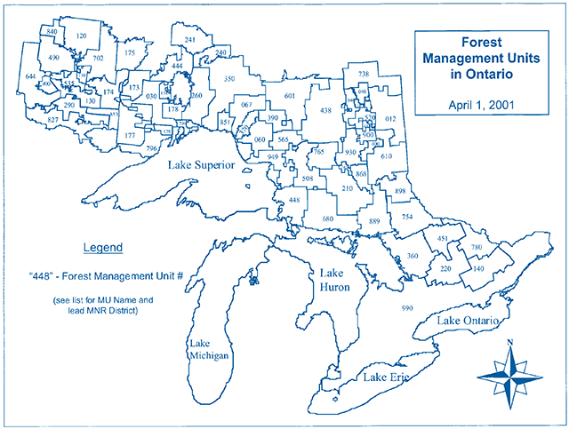
Enlarge Map of Forest Management Units
List of Forest Management Units in Ontario 2001/2002
(designated under the Crown Forest Sustainability Act (1995), Section 7)
| MU # | MU Name | Status | Lead District | Region |
|---|---|---|---|---|
| 448 | Algoma Forest | SFL | Sault Ste. Marie | NE |
| 451 | Algonquin Park Forest | AFA | Algonquin Park | SC |
| 444 | Armstrong Forest | SFL | Thunder Bay | NW |
| 220 | Bancroft-Minden Forest | CR | Bancroft | SC |
| 067 | Big Pic Forest | SFL | Wawa | NE |
| 370 | Black River Forest | SFL | Wawa | NE |
| 178 | Black Sturgeon Forest | SFL | Nipigon | NW |
| 173 | Brightsand Forest | SFL | Thunder Bay | NW |
| 175 | Caribou Forest | SFL | Sioux Lookout | NW |
| 520 | Cochrane | CR | Cochrane | NE |
| 177 | Dog River-Matawin Forest | SFL | Thunder Bay | NW |
| 410 | Driftwood Forest | SFL | Cochrane | NE |
| 535 | Dryden Forest | SFL | Dryden | NW |
| 174 | English River Forest | SFL | Dryden | NW |
| 827 | Fort Frances-Flanders Forest | SFL | Fort Frances | NW |
| 360 | French-Severn Forest | SFL | Parry Sound | SC |
| 438 | Gordon Cosens Forest | SFL | Hearst | NE |
| 601 | Hearst Forest | SFL | Hearst | NE |
| 290 | Highrock Forest | SFL | Fort Frances | NW |
| 012 | Iroquois Falls Forest | SFL | Cochrane | NE |
| 350 | Kenogami Forest | SFL | Nipigon | NW |
| 644 | Kenora | CR | Kenora | NW |
| 651 | Kiashke River | Thunder Bay | NW | |
| 702 | Lac Seul Forest | SFL | Sioux Lookout | NW |
| 260 | Lake Nipigon Forest | SFL | Nipigon | NW |
| 796 | Lakehead Forest | SFL | Thunder Bay | NW |
| 565 | Magpie Forest | SFL | Wawa | NE |
| 140 | Mazinaw-Lanark Forest | CR | Bancroft | SC |
| 738 | Moose River | CR | Cochrane | NE |
| 390 | Nagagami Forest | SFL | Wawa | NE |
| 240 | Nakina North Forest | SFL | Nipigon | NW |
| 754 | Nipissing Forest | SFL | North Bay | NE |
| 680 | Northshore Forest | SFL | Sault Ste. Marie | NE |
| 241 | Ogoki Forest | SFL | Nipigon | NW |
| 780 | Ottawa Valley Forest | SFL | Pembroke | SC |
| 851 | Pic River Ojibway Forest | SFL | Nipigon | NW |
| 765 | Pineland-Martel Forest | SFL | Chapleau | NE |
| 840 | Red Lake Forest | SFL | Red Lake | NW |
| 930 | Romeo Malette Forest | SFL | Timmins | NE |
| 853 | Sapawe Forest | SFL | Fort Frances | NW |
| 868 | Shiningtree Forest | SFL | Timmins | NE |
| 040 | Smooth Rock Falls Forest | SFL | Cochrane | NE |
| 990 | Southern Ontario | SFL | various | SC |
| 210 | Spanish Forest | SFL | Sudbury | NE |
| 030 | Spruce River Forest | SFL | Thunder Bay | NW |
| 889 | Sudbury Forest | SFL | Sudbury | NE |
| 508 | Superior Forest | SFL | Chapleau | NE |
| 898 | Temagami | CR | North Bay | NE |
| 610 | Timiskaming Forest | SFL | Kirkland Lake | NE |
| 900 | Timmins | CR | Timmins | NE |
| 400 | Timmins Forest | SFL | Timmins | NE |
| 120 | Trout Lake Forest | SFL | Red Lake | NW |
| 130 | Wabigoon Forest | SFL | Dryden | NW |
| 949 | Wawa Forest | SFL | Wawa | NE |
| 490 | Whiskey Jack Forest | SFL | Kenora | NW |
| 060 | White River Forest | SFL | Wawa | NE |
Status: SFL Sustainable Forest Licence; CR Crown Managed; AFA Algonquin Forest Authority
Note: Forest management units in effect April 1, 2001 to March 31, 2002.
This information is subject to change.
Prepared: July 11, 2001
Issue resolution for mapping tourism values
Preamble
The purpose of this document is to record the understanding reached among members of the Tourism Guideline Working Group regarding the mapping of tourism values for the purpose of forest management planning and resource stewardship agreement (RSA) negotiations.
Both the forest and tourist industries have expressed concerns regarding mapped information. The tourist industry has noted that they have a need to express both their short and long term interests in the forest and that their interests are often best expressed by identifying “areas”. The tourist industry has an ongoing need to have its business interests understood. The forest industry is concerned that forest management planning remain the operational tool for determining how forest operations are conducted and that forest management planning not be used to make land use decisions. The forest industry has a need to identify tourism values so that prescriptions for directing forest operations can be developed for inclusion in forest management plans.
To resolve the issue, two separate maps can be prepared – a Tourism Values Map and a Tourism Business Interest Map.
Tourism Values Map
A Tourism Values Map will be maintained by MNR using data contained in its Natural Resource Values Information (NRVIS) data base in accordance with Appendix 1 “Criteria for Mapping Values for the Ministry of Natural Resources Natural Resource Values Information System”. Noteworthy criteria include the following:
- Tourism establishments will be classified as “remote, semi-remote and drive-in” using definitions contained in the Ontario government approved Resource Based Tourism Policy.
- Only those identifiable features which are considered integral to the operation of a tourism business will be mapped.
The Tourism Values Map will be produced by MNR, based on existing information in NRVIS and in consultation with the Ministry of Tourism tourism advisors.
Tourism Business Interest Map
A Tourism Business Interest Map is a map prepared voluntarily by a resource based tourist operator(s) showing those parts, or all, of a forest management unit that are important for their short and long term business interests. The map, if provided to MNR, will form part of the supplemental documentation to a Forest Management Plan. The forest management planning process will not require the production of such a map, and MNR will neither approve the map nor endorse any land use designations shown on the map.
The Tourism Business Interest Map is intended to assist in the negotiations of an RSA(s). Where an RSA is successfully negotiated, the forest management planning prescriptions contained in the RSA will be made available for public review and comment as part of the normal forest management planning (including plan amendment) process.
This direction is agreed upon and supported by the following members of Tourism Guideline Working Group.
- Heather Barns
- Betty McGie
- Stephen Harvey
- Bruce Hyer
- Dave Barker
- Bud Dickson
- Paul Jewiss
- Paul Glassford
- John McLaren
- Gerry Webber
- Rick Groves
- Sergio Buonocore
- Bill Thornton
Criteria for mapping tourism values for the Ministry of Natural Resources Natural Resource Values Information System
Introduction
This Guide is intended to assist with the identification of “mapable” tourism values. The purpose of setting out mapable tourism values and criteria is to support the Ministry of Natural Resources in its role as the custodian of an information system for all natural resource values. In the mapping of tourism values as directed by this Guide the Ministry of Tourism will work with the Ministry of Natural Resources to ensure that mapped information is complete and accurate. This information system maintained by Ontario and referred to as the NRVIS (Natural Resource Values Information System) only deals with physical things such as a lake, microwave tower, cottage or lodge. This information assists the Ministry of Natural Resources in a variety of planning and operational functions including the development of forest management plans. There are other things such as District Land Use Guidelines, public comments and, sophisticated computer models that assist planners with the development of plans and ‘on-the-ground’ actions.
After this “Guide” has been used revisions may be required based on operational experience with Resource Stewardship Agreement negotiations and forest management planning. Ontario’s Resource-based Tourism Policy gives particular recognition to the importance of tourism in Ontario’s forests.
Once mapped the tourism values may then be addressed in a Resource Stewardship Agreement (RSA), in a Forest Management Plan (FMP) or, in both. Following the preamble is a list of criteria for assessing whether or not something is a value. A list of actual values has also been presented as a tool. Individual circumstances must be considered to determine whether or not something is a value for the purposes of developing RSAs and FMPs.
There is a natural tendency for people involved in such complex work as forest management to attempt to simplify their planning environment. In this case it will be attractive to leap straight to the list of tourism values without first understanding the list’s significance. The reader is cautioned; the tourism values list will never be complete. Also, the relatively straightforward act of defining a value does little to establish the significance or relative worth of a value; it is the business case supporting a value that will attend to this. The list of criteria or considerations is much more significant. The list of criteria serves as a filter for determining whether or not a value will be mapped.
Managing for tourism values in the forest is challenging. The forest and tourist industries along with the Ontario government have signed a Memorandum Of Understanding which should assist all parties in meeting this challenge. The MOU takes the first step towards redefining the way in which two important users of the forest are engaged in planning their business operations. The seemingly simple act of mapping values is a vital aspect of the stage which is being set for the negotiation of local agreements between the forest and tourist industries. It is the ‘map’ which will represent those things that are important to the tourist industry upon which forestry prescriptions in RSA’s will be built. The “Tourism Values” map will be used ultimately in the development of operational forest management prescriptions. It is important to understand and distinguish between the value and the measures intended to address the value or “forest management prescriptions.”
This document addresses the Tourism Values Map which MNR will produce in consultation with the Ministry of Tourism to support RSA negotiations.
Data presented on this map will be reviewed regularly by both the forest and tourist industries and will be subject to change.
Generally speaking “tourism values” are natural or cultural resources found in the forest which are important to a tourism activity or experience in which tourists participate. Ultimately it is the tourist who defines a tourism value.
Values should relate, then, to the demand individuals have for the product/experience. Ontario’s tourist industry caters to a diverse range of clients. The diversity in client base renders the task of defining tourist values problematic. The industry has traditionally been classified as remote, semi remote and drive-in and depends on the availability and maintenance of a number of important values. Remoteness and wilderness are highly valued by segments of the tourist industry. These criteria do not address remoteness and wilderness; however, this in no way diminishes their significance.
Criteria for mapping tourism values
The value must be capable of being defined spatially.
For this mapping exercise values must be tangible; something that can be pointed to and touched or seen. There is a distinction between the value, the experience associated with a set of values and the measures taken to protect the value and associated experience. Both the value and associated experience have value to the tourism operator and must be considered in the development of a forest management plan or RSA. Remoteness and wilderness are important values to the tourism industry; however, they are not values which will be entered into NRVIS.
Ontario’s Resource-Based Tourism Policy provides definition for three categories of resource-based tourism: remote, semi-remote and drive-in based on the level of existing access.
The mapped information must be accurate
Decisions which consider the information can result in significant costs or losses to business.
The information must be verifiable
Decisions made and the actions taken as a result of these decisions will form part of a forest management plan. Forest management plans are legal documents, subject to audit and periodic review.
The information must be timely
Not all information may be readily available. When information gaps are apparent efforts should be made to gather sufficient information to consider the value effectively in an RSA and forest management plan. While some delay may be inevitable, extraordinary delays can upset the approval of a forest management plan which in turn may lead to significant business losses. Information should be provided in a timely fashion and addressing the gaps in information should be part of good business planning by the tourism business operator.
The value must be related to the operation of a tourism business
When seeking verification of a tourism value the tourist business operator may be required to demonstrate how the value contributes to the tourism business.
Documentation related to the value’s contribution to a tourism business may be contained in a business plan, marketing and promotional material or capital investment related to the value. There may be a need to ensure the confidentiality of this information and this can certainly be accommodated; however, the value itself will become public knowledge. Additional characteristics of the value and its use may assist with planning for the value including frequency of use, type of use, time of use and season of use. If the value is a recurring phenomena it may be prudent to state how common the value is (i.e. beaver pond vs. the highest hill in Ontario).
The value must be expressed in terms readily understood by both industries and the Ontario government
Forest management is complicated; for ease of expression and to facilitate communication among forest management planners lingo and jargon are in common use. Every effort should be made to ensure that the description of a tourism value is expressed in common every-day language. Attention to this will reduce the potential for misunderstandings.
- Lake edge or high water mark is an important reference point in the establishment of measures for protecting tourism values. The high water mark is a geodetic reference from which tree cover may be measured. While vegetative cover around lakes may address water quality concerns standing trees of a certain height and density may be required to address tourism interests associated with water bodies; measuring the distance of standing tree cover from the high water mark may be useful in delineating forestry prescriptions.
A forest value requiring special consideration as a tourism value is a value which does not receive consideration in any of the other ‘guidelines.’
There are many “guidelines” which forest managers must consider when developing a forest management plan. In some cases the values addressed in the “guideline” are important to tourism; however, their primary importance is as a component of the forest system or as part of the cultural fabric of the forest. The value placed on these by the tourist industry may not require any specific action to be taken. If, however, through the tourist industry’s use of a value, additional consideration must be given to that value then the value becomes a “tourism value.” This is perhaps best explained by example. Moose aquatic feeding areas are addressed by the Timber Management Guidelines for the Provision of Moose Habitat. If a tourism business markets a specific moose aquatic feeding area as a “moose viewing area,” a trail to the area is developed and viewing station established, then there may be special needs above and beyond the provision of habitat which forest managers should consider; the moose aquatic viewing area then becomes a tourism value. If on the other hand, the tourist business brochure simply states that there are abundant opportunities for seeing moose in the area of a lodge then moose aquatic feeding areas have no additional significance attached to them and they should not be defined as a “tourism value.”
- Every tourism value map must be in the support of one or more of the following resource based tourism interests as stated in the Tourism and Forestry Industry Memorandum of Understanding
- Natural aesthetics
- Remoteness, including maintenance of traditional means of access
- Maintenance of the perception of wilderness,
- Sustainability and enhancement of fish, game and wilderness opportunities necessary for tourism operations
- Maintenance of the perception of Ontario as a world class wilderness tourism destination
List of Tourism Values
It is not intended that prescriptions be developed in each forest management plan for each value listed; rather, only those values identified locally and understood to be important to the tourist industry will have special measures taken to protect them.
Tourism establishments
All establishments will be classified according to remote, semi remote, drive-in according to the definitions contained in Ontario’s Resource-based Tourism Policy.
- Remote tourism - a tourism resource, opportunity, value of potential development that is not accessible by road and is based on a remote wilderness experience where access is only gained through air, water or rail. The important attributes of this product include inaccessibility, isolation from visual and auditory impacts, and high quality environmental resources (e.g. fish and wildlife).
- Semi-remote tourism - similar to a remote tourism opportunity except that road access is limited and may be controlled through artificial means or the use may be limited to protect the resources, opportunity or value. The non-traditional means of access include: restricted road, ATV trail, marine
footnote 6 , and portage.footnote 7 The same attributes that are important to remote tourism are important here as well, except as how they are changed by the lesser amount of remoteness. - Drive-in resource-based tourism - includes unencumbered road access in regards to the use of the tourism resource. Important characteristics of this resource include full accessibility, composite use
footnote 8 , maintenance of both the visual and auditory environmental settingfootnote 9 and access to good quality resources.footnote 10
Main base lodges
Description: fixed roof accommodation, has a current Resource-based Tourism Licence and commercial land use permit or other form of property tenure. The Tourism Act defines a “base of operations” as ‘a license tourist establishment or an air carrier licensed under the laws of Canada from which a tourist outfitter maintains facilities for communication, transportation and the complete maintenance of office records.’
Outpost camp
Description: fixed roof accommodation, has a current Resource-based Tourism Licence and commercial land use permit or other form of property tenure. The Tourism Act defines an outpost camp as any fixed or portable rental unit that is remote from a base of operations and accessible only by air, water or forest trails, and is used for commercial purposes.
Roads & Trails
Recreation Trails
- Description: Winter (dog sled trails, cross country trails, snowshoe trails, snowmobile trails, etc.)
- Summer (ATV trails, horse trails, portage trails, etc.)
- All Season (hiking trails, hunting trails, etc.)
Access: Description: road, flight path, water route or rail line providing access to a tourism business or associated value. It is recognized that entire flight paths cannot be addressed; rather, only segments which can be reasonably associated with a tourism experience should be considered a value. Usually it is the final approach portion of a flight path which is a concern.
Tourism Access Points: Description: landing, access to water body, access to railroad or other modes of transportation specifically used to access a tourism establishment.
Ancillary features
Shore Lunch & Picnic Sites
Description: includes shore lunch site, etc.
Viewpoint
Description: point for viewing prominent scenery or vista, etc.
Camping Sites
Description: Type “B” Outpost Camp (i.e. Mini LUP) (e.g. moose camps, bear camps, etc.)
Boat Caches
Description: the site where boats are cached according to an MNR permit (applicable in Northwestern Ontario.)
Canoe Routes
Description: route actively marketed for use by guests of Ministry of Tourism licensed resource-based tourism establishments.
Navigable Channel
Description: Generally a narrow channel connecting two water bodies used by guests of a tourism establishment
Water-related features
Swimming Beach
Description: Not a public beach, but, a beach to which guests from a tourism establishment are directed.
Wildlife-related features
Fish and Wildlife Viewing Site
Description: that part of the forest that is especially important for viewing of wildlife including moose viewing area, bird feeder area, deer viewing area.
Wildlife Hunting Stations
Description: duck blinds, bear baiting areas, deer stands etc.
Cultural/heritage-related features
Cultural Heritage sites
Description: An old building, mine archaeological site, interpretive site, historical site or other cultural feature which because of its use by a tourist establishment requires more protection than that afforded by the “Cultural Heritage Guidelines.”
© 2001 Queen’s Printer for Ontario
Single copies of this publication are available at no cost from:
Natural Resources Information Centre
300 Water Street
P.O. Box 7000
Peterborough, ON
K9J 8M5
Current publications of the Ontario Ministry of Natural Resources, and price lists are also available from this office.
Telephone inquiries about ministry programs and services should be directed to the Natural Resources Information Centre:
Peterborough
General Inquiry
1-800-387-7011
Renseignements en francais
1-800-667-1840
Fax: 1-705-755-1677
NRISC@ontario.ca Email: NRISC@ontario.ca
Other government publications are available from Publications Ontario, Main Floor, 880 Bay St., Toronto, ON.
For mail orders write Publications Ontario, 50 Grosvenor St., Toronto, Ontario M7A 1N8
This publication should be cited as:
Forest Management Branch, Management Guidelines for Forestry and Resource-based Tourism. Ont. Min. Nat. Res., Queen’s Printer for Ontario, Toronto, ON. xxxp.
51544
(2.5kP R., 19 07 01) ISBN 0-7794-1568-X
Footnotes
- footnote[1] Back to paragraph Excerpt from RSA MOU 2000
- footnote[2] Back to paragraph Portage refers to canoe routes
- footnote[3] Back to paragraph Composite use refers to two or more compatible uses co-existing in proximity to one another
- footnote[4] Back to paragraph Refers to the protection of skyline areas of concern and man-made noise abatement
- footnote[5] Back to paragraph Refers to the importance of having access to ecologically sustainable land,
- footnote[6] Back to paragraph Marine refers to traditional waterway access.
- footnote[7] Back to paragraph Portage refers to canoe routes
- footnote[8] Back to paragraph Composite use refers to two or more compatible uses co-existing in proximity to one another
- footnote[9] Back to paragraph Refers to the protection of skyline areas of concern and man-made noise abatement
- footnote[10] Back to paragraph Refers to the importance of having access to ecologically sustainable land