Manitou Islands Provincial Park Management Plan
This document provides policy direction for the protection, development and management of Manitou Islands Provincial Park and its resources.
Management Plan
Ontario Ministry of Natural Resources
© 1990 Queen’s Printer for Ontario Printed in Ontario, Canada
Single copies of this publication can be obtained from Ontario Ministry of Natural Resources, North Bay District Office, P.O. Box 3070, Hwy. 63, North Bay, Ontario, P1 B 8K7, telephone (705) 474-5550.
Price: $2.00 (Tax Included)
ISBN 0-7729-2088-5
Approval statement
We are pleased to release this management plan for the Manitou Islands Provincial Nature Reserve. The designation of these four islands for protection under the Provincial Parks Act and implementation of the policies herein will ensure their ecological integrity for future generations.
The Manitou Islands are representative of island ecology in Lake Nipissing. They are home to a variety of plant communities, outstanding colonial nesting habitat for Great Blue Heron and Osprey, and an intriguing geological history. They offer a high quality recreational setting 10 kilometres from North Bay for day use, water-based recreation. This nature reserve and the long-term protection of its provincially significant resources will be sustained through the cooperative efforts of the Ontario Ministry of Natural Resources, the Ontario Heritage Foundation, Nature Conservancy of Canada, and local naturalist clubs.
M.A Klugman
Regional Director
Northeastern Region
Norm R. Richards
Director
Parks and Recreational Areas Branch
1.0 Introduction
Four islands in Lake Nipissing, 10 kilometres southwest of North Bay, make up the Manitou Islands Provincial Nature Reserve (Figure 1).
The Manitou Islands joined other provincial nature reserves in the Ontario Provincial Park system in 1989, representing distinctive wildlife, natural habitats, bedrock, and landforms of this area of the province.
The Ontario Ministry of Natural Resources will manage the Manitou Islands in cooperation with the Ontario Heritage Foundation (OHF), an agency of the Ontario Ministry of Citizenship and Culture. Their mandate is to preserve and promote Ontario’s natural, historical, archaeological, and architectural heritage. As an agent of the Crown, the OHF accepted a gift of the majority of land on Great Manitou Island in 1982 from a private donation through the encouragement of the Nature Conservancy of Canada to protect habitats associated with a large Great Blue Heron colony. To evaluate the ways of protecting the needs of the heronry, the OHF commissioned a study of other resources in the immediate area in 1984. On the basis of this work, it was determined that there were a variety of resources and potential uses and recommended that a management strategy be prepared for the four islands as a provincial nature reserve.
Policies for resource protection and use of the Manitou Islands were proposed by the Ontario Ministry of Natural Resources in a preliminary management plan. This was reviewed with the public in 1986.
Figure 1: Regional setting
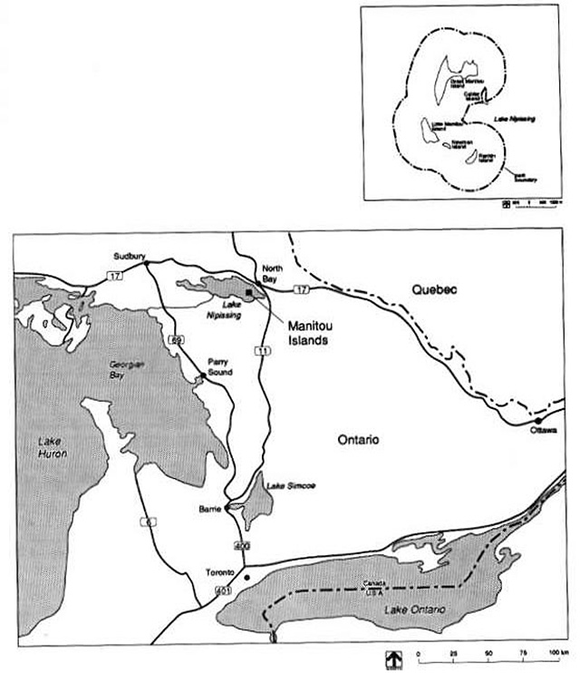
Enlarge figure 1: Regional setting
1.1 Resource characteristics
This nature reserve is representative of island ecology in Lake Nipissing. The islands are underlain by glacial till and lacustrine deposits associated with small, weekly, broken bedrock occurrences. The environmental conditions on a site control vegetation development (i.e. soil moisture regime, rooting medium or substrate, and microclimate). A life science survey of the Manitous (Noble 1984) determined that conditions here range from dry rock to wet sandy sites. Microclimate is normal to warmer than normal for this site district (5E5). The major plant communities are forests treed with Basswood, three species of Ash, Silver Maple, White Birch, White Cedar, Burr Oak, and Sugar Maple. A mosaic of thickets with Striped Maple, Chokecherry, Canada Yew, Poison Ivy, and Ground Hemlock are common. The Great Blue Heron colony, Osprey nesting sites, and some 50 other species of breeding birds are very important elements of the ecology of these islands in the Lake Nipissing basin.
The Manitou Islands have an intriguing geological history. The majority of the bedrock underlying Lake Nipissing is metamorphic rook some 2.5 billion years old (Late Precambrian Period). The island bedrocks are actually much younger, with an age of 565 million years (Middle Cambrian Period). The core of each island is the remnant of a rock that crystallized after welling up from the depths of the earth during an unsettled geological environment. This occurred during a rift or separation and cave-in of the crust of the earth, which extended from the western end of Lake Nipissing to the St. Lawrence valley. The opening brought molten rock from great depths below the crust, which bubbled up to solidify as a cone-like structure within the older rocks of the crust. If you look at the Manitou Islands from the air, they appear as a broken ring - the outline of one of these intrusive cones. A geological survey of the islands identified this feature as the Manitou Islands Complex.
Erosion has broken down the complex overtime. One major erosional event was succeeded by the deposition of limestone rock on the islands. Some 450 million years ago (Ordovician Period), a shallow ocean environment was present engulfing an area including the Great Lakes to James Bay. Organisms living in that environment were deposited and their fossils are now seen within horizontal sedimentary layers of buff coloured lime-stones in limited outcrops along the island shorelines.
Glaciation was active in this area between 45,000 and 9,000 years ago, scouring and reshaping the surface. This left a veneer of soils over much of the Canadian Shield. The sandy tills on the islands and the south shore beach of Great Manitou Island have their origin from their soils.
The islands have been used for seasonal human habitation for at least the last 2,000 years. Archaeological investigations have uncovered artifacts associated with Woodland Indian cultural technologies. A purported historical fur trade post and stopover use of the islands have yet to be documented.
Recent man-made developments occurred on Little Manitou and Newman Islands. These locally significant mineral exploration activities resulted in subsurface and surface disturbance of both islands. There is a small lime kiln structure on Little Manitou Island. It is all that remains from the use of limestone during the construction of the North Bay portion of the Canadian Pacific Railway. A headframe and some 135 m of vertical shaft were active on Newman Island between 1953 and 1960. Uranium deposits were explored in that area. The ~ was never brought to production.
2.0 Classification
The Manitou Islands are classified as a provincial nature reserve. This will enable the Ontario Ministry of Natural Resources to protect the landform associated with the Manitou Islands Complex, island and lakebed limestone bedrocks, habitat and seasonal nesting use by Great Blue Heron and Osprey, and archaeological and historical sites. Public awareness of these features will be enhanced by the provincial nature reserve designation.
3.0 Park goal
The following goal and objectives have been derived from the Ontario Provincial Parks Planning and Management Policies (OMNR 1978). They will guide zoning, resource management, client services, and development of this provincial nature reserve.
"Manitou Islands Provincial Nature Reserve will represent distinctive natural habitats and landforms of the province to be protected for educational purposes and as gene pools for research to benefit present and future generations".
Management will protect and perpetuate the islands' natural and cultural features. Existing day use recreation will be permitted to continue.
4.0 Objectives
Provincial objectives for protection and heritage appreciation will guide the management and use of the provincial nature reserve.
4.1 Protection
The protection objective is:
"Manitou Islands Provincial Nature Reserve will protect provincially significant, special, and representative features of Lake Nipissing’s natural history."
The islands contain significant natural and cultural features (Figure 2). Great Blue Heron and Osprey nesting sites will be the central resources to protect. The provincial nature reserve, geology, and landforms represent different geological times. The oldest bedrocks are Late Precambrian age metamorphics and middle Cambrian age igneous intrusives. Ordovician age limestones as well as Quarternary glacial deposits are also present. Island landforms are not being modified in any significant way by erosional processes of Lake Nipissing.
The Manitou Islands Provincial Nature Reserve will protect plant and animal communities that are representative of the present day ecology of islands in Lake Nipissing.
Cultural features related to Middle Woodland archaeological sites and recent mineral exploration works will be protected.
Manitou Islands Provincial Nature Reserve includes four islands. One of these, Great Manitou, is managed through a custodial agreement with the Ontario Heritage Foundation. The purpose of the agreement is to ensure that the natural and cultural features of the Island are protected.
4.2 Heritage appreciation
The heritage appreciation objective is:
"Manitou Islands Provincial Nature Reserve will provide opportunities for unstructured, individual exploration and appreciation of the natural environment."
Use and development of the Manitou Islands will not disturb the heron and Osprey nesting areas. Development, which is proposed for Great Manitou Island, will not encourage access to their critical nesting habitats. These biological resources and those concerned with geological and archaeological features will be interpreted to the public through means that are compatible with the protection objective.
Recreation use and park operation services will be accommodated on small areas of Great Manitou and Rankin Islands. An historical zone on Newman Island will provide interpretation of all themes related to this provincial nature reserve through viewing facilities and outdoor displays.
5.0 Boundary
The boundary for the nature reserve was identified on the basis of protecting related natural and cultural features.
Most of the property in the island group is Crown land. Patent lots that remain on Great Manitou Island will be acquired as they become available and as funds permit. One land use permit, the only alienated land on Rankin Island, will continue. Calder Island and other private properties are not affected by this plan.
The Manitou Islands are located in an unorganized part of the District of Nipissing with no zoning orders or official plans in effect as of publication of this document.
Prior to February 9, 1981, Great Manitou Island was privately owned. The easterly part of that island had been subdivided in 1920, and 29 lots were sold over the years. The unsold lots were owned by Michael J. Brophy, In Trust, K.Y.B. Northern Limited, and Great Manitou Park Company Incorporated. The mining rights were leased to Nova Beaucage Mines Limited for a period of 99 years beginning April 7, 1953. That lease was forfeited in 1984.
Principle owners of the Great Manitou Island property sold their holdings to a private individual who, in turn, donated it, through the efforts of the Nature Conservancy of Canada and the Ontario Heritage Foundation, to the Crown in 1982. Several other individual lots have since been purchased by the Crown. Negotiations to purchase the remaining lots are continuing.
The Ontario Ministry of Natural Resources holds an agreement with the OHF to manage Great Manitou as part of the provincial nature reserve.
Figure 2: Significant areas
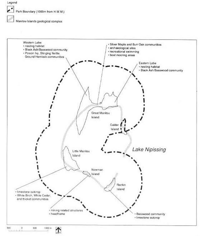
Enlarge figure 2: Significant areas
6.0 Park zoning
Lands and waters within the Manitou Islands Provincial Nature Reserve are zoned to their most appropriate use to satisfy the park goal and objectives. The zones are Access, Nature Reserve, and Historical (Figure 3).
Management measures to protect nature reserve resources are discussed in the Resource Management section.
6.1 Access zones
The islands are quite visible from points in North Bay and Highway 17 west. From certain vantage points, they can be viewed as part of the overall landscape of Lake Nipissing. People travel to the islands by boat from North Bay and other centres for day use, water based recreation. Yachts sometimes moor offshore. The islands also serve as a refuge to storm-bound boaters.
The Ontario Northland ferry service, Chief Commanda II, passes through the islands on its North Bay - French River cruise.
Two access zones will act as staging areas where a minimum of facilities are required for day use recreation and park operations. Camping will not be permitted on any of the islands.
Great Manitou Island beach and operations base A1 (2 ha) access zone
The south facing beach of Great Manitou Island will be signed as a day use area to accommodate existing boating and swimming. Sanitary facilities will be maintained. No docking structure will be provided at the public beach. Visitors will be made aware of the need to limit their use to the cleared area of backshore to avoid disturbance of habitat and seasonal use of the Great Blue Heron and Osprey nesting on the island. A plaque acknowledging the work of the Ontario Heritage Foundation, the Nature Conservancy of Canada, and their donor for land purchases will be placed on site. In the future, some self-use interpretive displays may be installed here.
The existing frame building, about one kilometre east of the beach, will be maintained as a base of operations for the nature reserve. Uses of the building will be determined in the operating plan (see section 10.2).
Seasonal storage A2 (1 ha) access zone
Winter ice fishing huts have been traditionally stored on the east shore of Rankin Island in a location held as a land use permit for that purpose.
The site is convenient to the winter operational needs of the Lake Nipissing ice fishing businesses. The low relief of the island makes it easy to get the ice huts on Lake Nipissing for the winter and then acts as a storage area with the arrival of spring.
This site is adjacent to the best representative Basswood forest stand on the Manitou Islands. An ecological evaluation to provide a more detailed description of the use of the area and the condition of the Basswood stand is needed to determine whether there are any impacts on the Basswood stand as a result of the present pattern of use.
It is determined that this use causes impact to the Basswood stand, then a suitable alternate ice hut storage site will be designated off the islands.
6.2 Nature reserve zones
Four nature reserve zones will protect the significant geological, biological, and cultural elements of the Manitou Islands. Park development will not occur in these zones.
Great Manitou Island NR1 (80 ha) Nature Reserve Zone
The following features will be protected:
- the Great Blue Heron colony - one of the largest known colonies in interior Canada
- the Osprey nesting sites - significant given that there are four active nests (1984) on one island
- representative communities of Black Ash, Silver Maple, Basswood, White Birch, Burr Oak, and
- White Cedar forests with Ground Hemlock, Choke-cherry, and Poison Ivy thickets
- the Manitou Islands Complex’s geological history as recorded in the outcrops of the island landform;
- Middle Ordovician limestone outcrops on the island shoreline
- the glacial landform (Quaternary Period) as recorded in surficial material; and
- Woodland archaeological sites, which are significant in piecing together the native habitation and travel patterns in the area
Figure 3: Development and Zoning
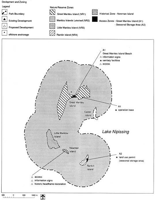
Enlarge Figure 3: Development and Zoning
Manitou Islands Lakebed NR2 (200 ha) Nature Reserve Zone
This zone includes submarine landforms associated with the four islands that occur in the provincial nature reserve. The submarine landforms are the "roots" of bedrock types that outcrop on the four islands and, as such, will be protected to keep the Manitou Islands Complex’s geological feature and limestone pavements intact. The Calder Island area will not be represented.
These submarine features will not be modified through park development.
Little Manitou Island NR3 (30 ha) Nature Reserve Zone
This island has the most extensive bedrock outcrops of all the islands in the group. Although there is no nesting presence of Osprey or Great Blue Heron here, these birds feed along the shoreline. The best representative communities of White Birch, White Cedar, and Choke-cherry thickets found on the islands grow here.
Rankin Island NR4 (10 ha) Nature Reserve Zone
All bedrock types in the area occur on this island. Although there are no nesting Great Blue Heron or Osprey on Rankin Island, there are feeding sites here. The upland thickets and an almost pure stand of Basswood are better represented here than on any other island in the Manitou Islands group.
6.3 Historical zone
One historical zone covering Newman Island will represent "historic" mineral exploration of the Manitou Island Complex. It will be managed to give recognition to the broader objective of heritage appreciation of all themes occurring in the nature reserve.
Newman Island H1 (4 ha) historical zone
The headframe will be retained as a landmark representative of mineral exploration and the Manitou Islands Complex. The mine shaft was sealed in 1984. The actual workings (1953 to 1960) developed a vertical shaft of 135 metres with 762 metres of drifts and crosscuts to examine uranium mineralization before the site was abandoned.
Although a pilot treatment plant to process the ore was constructed on the north shore of Lake Nipissing, the island mine never came to production, and the site was abandoned in 1960.
Collapsed buildings on the island will be cleaned up. The feasibility of restoring the headframe and maintaining a day use interpretive facility here will be evaluated: outdoor displays, a two kilometre trail, and lookouts.
7.0 Resource management
Management and planning policies (1978) for provincial nature reserves and the North Bay District Land Use Guidelines (1983) provide the broad context for resource management. This section adds detail to those policies with guidelines that are specific to the Manitou Islands. Resource planning will follow the overall principle that significant, special, and representative resources are important to the integrity of the nature reserve. Interference with the natural geomorphological and ecological processes will be minimized.
There have been no active resource management programs to enhance the natural heritage of the islands in the past. Measures to sustain the resources that are significant, special, and representative are described as follows for landforms, vegetation, wildlife, fisheries, and cultural features. These measures will be written into a park operations plan.
7.1 Landforms
Submarine and surface expressions of the landforms associated with the Manitou Islands Complex, the Ordovician limestones, and island shorelines will not be altered through extraction or in filling. Minor alterations may be considered to upgrade docking facilities in two locations. A boat dock for operation needs of the nature reserve will be maintained within Zone Al as part of the operations base. Should there ever be a need to accommodate small craft or a tour boat stop at the Manitou Islands, there is a disturbed area where a large dock once served Newman Island for mineral exploration purposes. The plan will have to be reviewed to deter mine the extent of docking needs, should this be proposed in the future.
7.2 Vegetation
Vegetation management planning will recognize the dynamic succession of forests, thickets, open areas, and shoreline wetlands. All plants including Poison Ivy, Stinging Nettle, and Canada Yew are integral to the representative communities on the islands.
Suitable nesting habitat for Great Blue Heron and Osprey will be encouraged.
The existing nesting areas of heron and Osprey will receive adequate vegetation buffering to prevent disturbance by recreational uses of the access zone on Great Manitou Island.
The Rankin Island Basswood stand will be monitored to determine if there is any encroachment by uses associated with the adjoining land use permit. If the permitted use is found to affect the Basswood stand, then a location for ice hut storage will be developed elsewhere and the Rankin Island site would be allowed to recover through natural succession.
Non-native plant species will not be deliberately introduced to the nature reserve. Where it is determined that such disturbance has occurred on the Manitou Islands in the past or should it unintentionally happen in the future, a management program will be developed to restore natural vegetation to the disturbed site(s).
There appears to have been a low incidence of natural fires on the Manitou Islands. In as much as fire may be a natural occurrence, the forest makeup suggests that it is not an integral process in vegetation succession on the islands.
Given the small area on each island and the potential hazards to the Great Blue Heron and Osprey nesting sites and park visitors, fires will be suppressed in accordance with the approved park plan and fire operations plan for the Northeastern Region to ensure that park objectives are met.
Commercial logging is not permitted.
7.3 Wildlife
The management of wildlife will recognize the special characteristics of species diversity and the natural ecology of island communities in Lake Nipissing. Islands, generally speaking, have fewer total numbers of species and lack many predator species found in similar main land habitats. Some large populations of certain species often develop in response to the lack of predators, available food supplies, and suitable breeding habitats. This seems to have been the case for Great Blue Heron and Osprey on Great Manitou Island.
Protection of heron and Osprey populations is central to the ecology of the Manitou Islands. These wildlife resources will be monitored. In this way, optimum nesting ecology and population dynamics will be determined. As a result, vegetation management may be required as described in the management guidelines for heronries (1984) and Osprey (1983).
Sport hunting and trapping are not permitted.
7.4 Fisheries
Sportfishing will be permitted within the Manitou Islands Provincial Nature Reserve. Commercial fishing, including commercial bait fishing, will not be permitted.
7.5 Cultural features
Two Woodland Indian archaeological sites and a recent history of mineral exploration contain significant and representative cultural features that will be protected.
The Woodland sites and other sites on Lake Nipissing contain artifacts that are being used to interpret these ancient cultures' resource utilization and travel patterns in the region. Further archaeological work will be con ducted to understand the significance of the Manitou Islands as a resource area to these early peoples. A complete archaeological salvage will be undertaken on sites that are vulnerable to disturbances.
The historical zone on Newman Island contains what remains of the mineral exploration infrastructure from the 1950's. The headframe will be evaluated to determine the feasibility of retaining it as a landmark and an interesting feature to relate cultural and natural heritage to park visitors (see Visitor Services section).
8.0 Land management
The management of the Manitou Islands Provincial Nature Reserve will be guided by the principle of having a natural landscape free from the modified impacts of man. The Provincial Park Planning and Management Policies (OMNR 1978) for provincial nature reserves will be adhered to. The following are specific policies for patent properties.
8.1 Patent properties
The patent properties on Great Manitou Island are being acquired on the open market as lots are put up for sale and as funds and priorities permit. The one land use permit on Rankin Island will be allowed to continue if it is found that it does not negatively impact on the adjacent stand of Basswood. Additional areas will not be available in any form of tenure. Calder Island will remain outside Manitou Islands Provincial Nature Reserve.
9.0 Operations policies
Operations will be managed in accordance with the general planning and management policies for provincial nature reserves (1978). Specific direction, where required to meet the particular needs of the Manitou Islands, will be provided through visitor services planning and park operations planning (see Development section). Minimum operating standards for day use areas in provincial parks will apply.
9.1 Visitor services
A visitor services plan will be developed. This will involve area parks and other agencies as appropriate to relate the following themes:
- dynamic earth history associated with the Manitou Islands Complex’s geological processes and limestone bedrock environments
- Manitou Islands' ecology relative to the plant and animal communities on Lake Nipissing
- the ecology of Great Blue Heron and Osprey: their breeding habitat needs, feeding range patterns, and population
- the archaeology and history of human habitation and resource use of the Manitou Islands from native peoples to fur trade to mineral exploration and finally to recreation and conservation activities
Self-use information about all the themes will be provided through the brochure for the provincial nature reserve program and a district fact sheet.
Visitors to the nature reserve will learn about park resources through a park sign system. This will feature boundary identity; hazards of travel outside the Great Manitou Island access zone, and interpretation of specific park themes. Passive outdoor displays on Great Manitou Island and active outdoor displays and viewing areas on Newman Island, including the possible restoration of the island head-frame, will be considered in the visitor services plan. Methods of offsite interpretation of park themes will be considered - existing Highway 17 rest stop overlooking Lake Nipissing and Ontario Northland ferry service operations, and other parks/agencies.
All information concerning the park will carry the message of respecting the needs of nesting bird species - Great Blue Heron and Osprey. The overall low relief, lack of typically "nice scenery", and extensive communities of bothersome plants (i.e. Poison Ivy, Stinging Nettle, Canada Yew), are aspects that have contributed to the protection of the heron and Osprey populations. The area, due to its fragile and sensitive nature and park classification, will not be marketed for use. Rather, information about the area will encourage people to be aware of other locations where similar resources can be viewed.
9.2 Research
Research is encouraged in provincial nature reserves. Persons are permitted to conduct research in the Manitou Islands Provincial Nature Reserve. Policies and guidelines apply: approval through the Provincial Park Research Policy, regulations of the Game and Fish Act, Management Guidelines for Heronries (1984), and Management Guidelines and Recommendations for Osprey in Ontario (1983). All proposals that will potentially further an understanding of park themes outlined in the Visitor Services section will be carefully considered.
9.3 Recreation management
Day use activities will continue according to the park operations plan: sun bathing and swimming on Great Manitou (Zone Al), and boating, fishing, and wildlife viewing. The area will not be marketed as a day use destination.
Recreational travel in the nature reserve will be monitored in the spring and early summer. This will determine whether there are needs for protection during the critical nesting period.
As identified above, the potential recreational uses of Newman Island will be evaluated; and if it is found that certain facilities could enhance the achievement of the nature reserve objectives, then they will be pursued (see Development section).
10.0 Development
The location, design, and materials of all facilities constructed within the Manitou Islands Provincial Nature Reserve will, to the furthest extent possible, minimize intrusion on nature reserve resources. All development will be based on site and development planning to provide approved site plans that ensure that resources are protected. A park operating plan will be prepared to guide ongoing management of resources as development occurs. This will conform to the requirements of the Environmental Assessment Act and other appropriate legislation.
The following facilities will be proposed through work program planning and special funding initiatives.
10.1 Sign system
A sign system, consistent with the provincial nature reserve program, will provide an identity for the islands to inform the public about nature reserve resources and direct visitors to facilities and services offered in the park. This will limit recreational use to the Great Manitou Island access zone beach and the Newman Island historical zone.
10.2 Operation base
The existing building on Great Manitou Island will be maintained as the park operation base. Use of this facility for recreation and resource management projects and as a research base will necessitate upkeep of the sanitary and dock facilities. Trees and shrubs will be kept out of the immediate area between the building and shoreline.
10.3 Great Manitou beach
The public vault privy facilities associated with day use recreation in this area will be maintained.
10.4 Highway 17 lookout
The Ontario Ministry of Transportation will be approached by the Ontario Ministry of Natural Resources to identify the need to continue to maintain the existing highway pull-off on Highway 17 west of North Bay. Interpretive displays could be established in this scenic look-out to provide information about the natural and cultural history of Lake Nipissing.
10.5 Newman Island
All that remains of past mineral exploration on the islands, some thirty years ago, is a small wooden head-frame. This abandoned headframe and the type of disturbance that occurred on the island in the past make it ideal for day use.
The feasibility of maintaining the headframe and trails for onsite interpretation will be evaluated. The top of the shaft will be kept sealed. All other derelict wood structures on this island will be removed. As needs warrant (see Visitor Services section), a dock facility could be developed here based on the location and design of the dock that was used during the mineral exploration period.
11.0 Implementation
The implementation of the approved management plan will involve the management and development of the Manitou Islands Provincial Nature Reserve. A park operating plan will be prepared and updated to guide park management and development. Work program planning and funding proposals will be based on the implementation of the following items according to these priorities over the next 20 years.
11.1 Short-term work program planning and park operations
An operations plan will provide specific guidelines to implement operational aspects of all park resource management, visitor services, and development needs:
- make basic information available to the public through the provincial park nature reserve program and through a district fact sheet
- develop a park sign system with site planning specifications to identify the park
- maintain the operations base
- ensure protection of Great Blue Heron and Osprey nesting habitat through vegetation resource planning and wildlife resource planning
- evaluate whether there are impacts on the Beasswood community on Rankin Island as a result of the activities associated with the land use permit. If there are none, then the use will be allowed to continue. If there are real impacts, then an alternate site for the land use permit will be identified
- prepare a visitor services plan and outline research priorities to further the understanding of the themes for island landforms and geology, ecology of nesting Great Blue Heron and Osprey, and archaeological resources
- monitor recreational uses of the nature reserve zones during critical nesting periods
- continue archaeological work and salvage threatened sites
- maintain services for the recreational use of the Great Manitou Island beaches
- conduct a feasibility study into the future of Newman Island’s headframe and docking facilities for day use, interpretive trail, and viewing purposes
- park staff will contribute to the preparation of related resource plans (e.g. fisheries and fire management)
11.2 Long-term special funding initiatives
The operations plan will also address long-term special funding initiatives:
- continue negotiations with land owners on Great Manitou Island to purchase the remaining patent lands to add these to the nature reserve
- depending on a positive outcome of the feasibility study for Newman Island interpretive approaches, prepare site plans and restore and maintain the Newman Island headframe, docking facility, outdoor interpretive displays, a trail, and lookouts
- once the visitor services plan is in place, the Ontario Ministry of Natural Resources should approach funding and management agencies to upgrade offsite interpretation (e.g. scenic lookout maintenance and development of the existing Highway 17 rest stop, and viewing opportunities associated with Ontario Northland services)
12.0 Plan review
The Manitou Islands Provincial Nature Reserve Management Plan will be reviewed on an ongoing basis throughout its 20 year life span.
If changes to the policies herein are needed at any time, the significance of changes will be evaluated; and if necessary, the plan will be reviewed with the public prior to formal amendment.
13.0 Public consultation
This park management plan is a result of a continuing consultation process that has considered the needs, desires, and opinions of a variety of interests.
Public involvement in the management plan first began during the spring of 1986 with news releases requesting public participation in three open house presentations scheduled for that summer. These open houses were held in early July. In June of 1986, copies of the preliminary management plan were mailed directly to interest groups and other government ministries. Recipients of the plan and the public attending the open houses were requested to submit within 30 days any comments regarding the management plan to the District Manager in North Bay. Copies of all comments received are available for viewing at the North Bay District Office. No outstanding issues were identified by the public.
In applying this park management plan, the Ontario Ministry of Natural Resources is committed to continuing this consultation with government agencies, other minis - tries, interest groups, and the public. It is important that the channels of communication that have been created by this consultation process be kept open.
14.0 Select references
Bloom, C. and W.L. Kershaw, Checklist of Breeding Birds of Manitou Islands for the Ontario Breeding Birds Atlas, 1984.
Bowman I. and J. Siderius, Management Guidelines for Heronries in Ontario , Wildlife Branch, Non-Game Program, 1984.
Kor, P., Manitou Islands Earth Science Inventory Checklist for Ontario Ministry of Natural Resources, 1982.
Lumbers, S. B., Geology of the North Bay Area. District of Nipissing and Parry Sound, Ontario Department of Mines and Northern Affairs, G.R. 94,1971, pp. 81-83.
Noble, T., Manitou Islands Biophysical Inventory for the Ontario Heritage Foundation, Ontario Ministry of Citizenship and Culture, 1984.
Noble, T., Life Science Survey of Site Region SE within the Northeastern Administrative Region for the Ontario Ministry of Natural Resources, 1988.
Ontario Ministry of Natural Resources, Ontario Provincial Parks Policy Provincial Parks Branch, Toronto, 1978. Ontario Provincial Parks Planning and Management Policies, Parks and Recreational Areas Branch, Toronto, 1978.
Penak B., Management Guidelines and Recommendations for Osprey in Ontario, Ontario Ministry of Natural Resources, Toronto, 1983. North Bay District Land Use Guidelines, 1983.
Rowe, R. B., Notes on Geology and Mineralogy of the Newman-Columbium-Uranium Deposit. Lake ~ Ottawa, 1954.
Smith, B. A., The Manitou Islands. Lake Nipissing Archaeological Survey , for the Ontario Heritage Foundation, Ontario Ministry of Citizenship and Culture, 1984. desires, and opinions of a variety of interests.