Mara Provincial Park Management Plan
This document provides policy direction for the protection, development and management of Mara Provincial Park and its resources.
ISBN-O-7729-2330-2
©1987 Government of Ontario
Additional copies of this publication are obtainable from:
Ministry of Natural Resources
Huronia District Office
Midhurst, Ontario
LO1 1XO
We are pleased to approve the Mara Provincial Park Management Plan, as official policy for the management and development of this park. The plan reflects this Ministry’s intent to protect natural and cultural features of Mara and maintain and develop high quality opportunities for outdoor recreation and heritage appreciation for both residents of Ontario and visitors to the Province.
M. Fordyce
Regional Director
Central Region
N. Richards
Director, Parks and
Recreational Areas Branch
1. Introduction
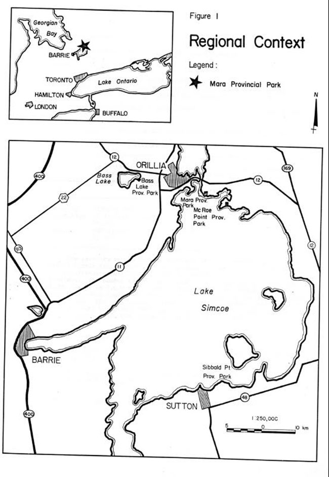
Mara Provincial Park has a land area of 40 hectares and water area of 5 hectares. The park is located on Lake Simcoe, 6 km south of Orillia off Highway #1.2 (Figure 1). It opened in 1.965 providing day use facilities (swimming and picnicking) and 1.00 campsites. The primary attractions of the park are its location on Lake Simcoe, with over 200 metres of sand beach, attractive wooded campsites and its proximity to Toronto (within 1½ hour drive).
The park is within the Georgian Lakeland Tourist Region, which provides a wide variety of recreation opportunities for both residents and non-residents. The area is well-known f or its cottaging, boating and other water-based recreation activities, as it is part of the Canada-Ontario Rideau, Trent-Severn (CORTS) waterway.
There are many tourist attractions close to Mara Park such as Ste. Marie Among the Hurons, Wye Marsh Wildlife Interpretation Centre, the Historic Naval and Military Establishment, the home of Stephen Leacock, the Champlain Monument, and the Big Chute Marine Railway, and McRae Point Provincial Park.
Mara Park is part of the lakebed of former glacial Lake Algonquin. The highest point in the park is a drumlinoid feature, which stretches several miles to the northeast. There are two wooded swamps covering approximately a third of the park containing a silver maple and ash forest. A small stream runs through the larger swamp in the northwest quarter of the park. The remainder of the park is open, formerly farmed land. Much of this open space has been planted with trees. The biological and geological features of the park are all of local significance. Inventory reports on these resources are available at the Huronia District Office in Midhurst.
The Mara Provincial Park Management Plan provides long term policy direction and guidelines to ensure orderly development and effective management of the park over the next twenty years.
2. Park Policies
2.1. Park classification
Mara Provincial Park is classified as a recreation park because of the excellent recreation opportunities it provides to large numbers of people.
2.2. Goal
The goal for Mara Park is:
- To provide a wide variety of outdoor recreation opportunities for large numbers of people in attractive surroundings.
Figure 1: Regional context
Enlarge Figure 1: Regional context
2.3. Objectives
The objectives for the park are outlined below.
2.3.1. Recreation:
- To provide visitors with opportunities to enjoy water and land based day use recreation such as swimming, sunbathing, picnicking, boating, fishing and hiking
- To provide the public with summer season camping opportunities; and
- To promote public safety for outdoor recreation activities
Table 1 Recreation Facilities in Mara Provincial Park
| Activity | Facilities/ Opportunities (Existing) | % of District Total | Facilities/Opportunities after redevelopment | % (after redevelopment) of District targets |
|---|---|---|---|---|
| Swimming | 213 M/39,800 | 1.3% | 213 M/39,800 | 1.1% |
| Picnicking | 75 tables! 18,000 |
1.6% | 150 tables/36,000 | 2.2% |
| Camping | 100 sites! 23,600 |
7.1% | 130 sites/30,680 | 5.4% |
The capacity of the day use parking lots (2) is 400 cars. There are 75 picnic tables, which can accommodate 260 people. As the demand for picnicking opportunities increases, additional picnic tables will be provided. The number of day-use visitors using the park in 1983 was 8,000, based on 2,000 daily vehicle permits and an average party size of 4.0. The annual number of camper nights averaged over the past 10 years was 20,000. The July-August occupancy rate for the same period was 68% with the park being full during many weekends. Additional campsites will be provided in the future as required to a maximum of 30 sites.
2.3.2. Heritage appreciation:
- To provide opportunities for the exploration and appreciation of the parks natural features
This objective will be accomplished through self-use information and interpretive programs.
* Ontario Recreation Supply Inventory (ORSI) space standards.
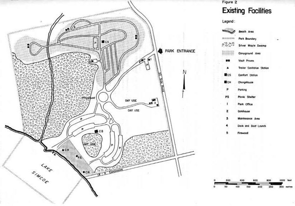
Figure 2: Existing Facilities

Enlarge Figure 2: Existing Facilities
2.3.3. Tourism:
- To contribute to tourism, the economy of the georgian lakelands tourist region, and the corts policies by providing residents and non-residents of ontario with opportunities to explore the unique features of the area
The park currently contributes almost a million dollars to the Provincial economy annually through park expenditures and tourist spending.
The Canada-Ontario Rideau, Trent, Severn, Corridor policies were adopted by the Federal and Provincial Governments in 1982. These policies encouraged the protection of public open space as well as the development of a coordinated recreation system in the Corridor.
2.3.4. Protection:
- To protect the significant natural resources of the park
This objective will be accomplished through zoning the silver maple swamp and upland forest area so as to protect these locally significant resources.
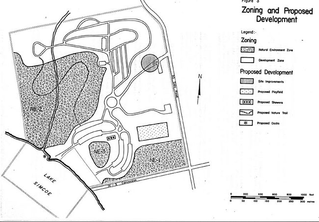
2.4. Zones and zone policies
Mara Park has two zones (Figure 3) based on the Provincial Parks Planning and Management Policies 1978.
2.4.1. Development zone:
This 26 hectare zone will accommodate facilities and services for a wide range of day-use recreation and camping activities. Development will be designed to limit environmental impacts on the land and water.
2.4.2. Natural environment zone:
This 14 ha zone will protect the locally significant natural features of the park. Zone NE1 (3.8 ha) is located in the southeast corner of the park and contains a small silver maple swamp complex. Zone NE2 (9 ha) is a larger silver maple swamp containing a small stream. Zone NE3 (1.2 ha) is a backshore sand plain forest containing outstanding species richness.
Development in the natural environment zone will be limited to facilities supporting low intensity day-use recreation such as trails and signage.
3. Resource management
The park’s natural resources will be managed in accordance with the general planning and management policies for recreation class parks outlined in the Ontario Provincial Parks Planning and Management Policies. Although the policies in this section are presented in separate categories, all subsequent planning and management will recognize the need to integrate these components as they are all inter-related.
** Economic Impacts of Provincial Parks in Ontario, 1980
Figure 3: Zoning and proposed development
Enlarge Figure 3: Zoning and proposed development
3.1. Landform and water management
The beach at Mara Park is primarily man-made. Additional sand will be imported to maintain the park’s artificial beach as required.
3.2. Vegetation management
Vegetation management activities in the park will promote forest regeneration where appropriate, wildlife habitat, and public safety. Commercial forest operations will not be permitted in the park.
A vegetation management plan will be prepared to identify those areas where natural succession will occur, to protect wildlife habitat and to identify vegetation management practices for the development zone. Consultation will involve district forest management, fish and wildlife and parks staff. The plan will be prepared according to vegetation management guidelines for parks.
In the natural environment zone those trees that are hazardous to park staff or visitors will be removed. Wildlife "den" trees will be retained provided they do not present a safety hazard. Insects and diseases threatening the forest values of the park will be controlled using biological means where feasible. Control will be directed as narrowly as possible. Significant vegetation communities which were identified in the life science inventory will be protected.
In the development zone the vegetation management will involve plantings of native species in the open areas for aesthetics and as vegetative buffers around building and storage areas.
The grassed areas will be managed to maintain the groomed appearance that is part of the park’s character.
The beach will be disced several times a summer as a mean of mechanical vegetation control.
3.3. Fish and wildlife management
Sport fishing will be encouraged in Lake Simcoe through the provision of a boat launch and docking facilities. Commercial fishing and bait fishing will not be permitted in park waters. Trapping will not be allowed, except for control of nuisance animals, which will be carried out under the supervision of the ministry. Hunting will not be permitted in the park.
4. Client services
4.1. Visitor services
The goal of the Mara visitor services program is to provide visitors with a variety of recreational and interpretive opportunities as well as information on the park, the surrounding area and other ministry programs.
The emphasis will be on self-use facilities. The district office will offer technical advice to the park staff. Guidance and assistance will also be provided by the staff of Bass Lake Provincial Park.
Visitor services consists of the following three components listed in order of importance, information, recreation, and interpretation.
4.1.1. Information:
Information concerning the park, points of interest in the Orillia area, and the policies and programs of the ministry must be delivered to the park user. This will be achieved through publications, newsletters, bulletin boards, displays and personal contacts. The main facilities associated with this component will be the park gate and perhaps the park office to be used for displays.
4.1.2. Recreation:
Emphasis will be placed on self-use recreation facilities such as children’s creative playgrounds, playfields for soccer or baseball, a nature trail and small play areas in the campgrounds. Some recreation equipment such as soccer balls, bats or volleyball nets may be made available on loan.
The park will be linked to local recreation events such as the annual Orillia Perch Festival and the lake trout fishing. The park will act as a base of operations for many fishermen, and boaters not only for the special events but also throughout the summer.
4.1.3. Interpretation:
Interpretive messages will be delivered through publications, a self-guiding trail and occasional campsite visitation by park staff. There are two interpretive themes of local significance associated with the park. They are earth science (lacustrine spit and beach and drumlin) and the waterway theme because of the park’s location on the Trent-Severn Waterway.
Special programs for educational groups will not be provided at Mara Provincial Park. However, the park may be used by groups for self-use outdoor educational field trips.
4.2. Recreation management
The park operating season is normally from June to September. During the off season the public may use the park for such activities as hiking, and cross-country skiing. Off-season parking is available at the park office.
The proximity of Mara Provincial Park to McRae Point Provincial Park has permitted recreation opportunities that were lost by shortened seasons at Mara Park to be picked up by McRae Point Park.
Existing facilities will be upgraded and additional ones provided, as required to enhance and maximize the recreational opportunities of the park.
4.3. Commercial services
Firewood is now provided by the private sector outside the park. As long as this service continues there will be no need to provide firewood in the park.
There is some potential in the park for a boating concession, (sailboats, canoes, fishing boats). This type of concession would be compatible with the parks goal and objectives and would be encouraged.
4.4. Marketing
The marketing of Mara Provincial Park will focus on the following items listed in order of priority:
- increasing tourist awareness of the park by requesting signage for the park on Highway 11
- increasing day use throughout the season by raising the park profile locally
- improving occupancy rate by attempting to hold present customers longer; and
- encouraging week-day camping.
5. Development
In all instances detailed site plans will be completed and approved En advance of any development. The requirements of the Environmental Assessment Act will be followed. In addition a park redevelopment plan will be prepared to guide the placement of facilities and changes identified below. A conceptual plan outlining the general location of the changes will be prepared as soon as possible.
5.1. Access and internal traffic circulation
The current access to the park is through the gate located just inside the park. During peak times traffic backups occur on the Township road. A complete review of the park access and internal traffic circulation is required for safety and efficiency reasons.
5.2. Camping areas
In view of the demand for campsites on Lake Simcoe there is pressure to expand the camping facilities. One alternative would be to convert the south day use parking lot into campsites, since it is not needed for day use. Approximately 25-30 new sites could be developed at very little cost as the road system already exists.
Another alternative would be to locate additional campsites in the area between the main tenance facilities and the gatehouse. This cleared area receives little use and has been recently replanted with native tree species. These and any other alternatives will be examined during the preparation of the park redevelopment plan. The new sites should be electrical as there are no other electrical sites in the park and there is a considerable demand for them.
Sandboxes and small swing and slide units will be installed near the campgrounds.
5.3. Day use areas
5.3.1. Picnic area:
The picnic area is adjacent to the beach. A picnic shelter provides cover from inclement weather. More tables can:
be placed in the day-use area as the demand increases (maximum of 150 tables). The northern day use parking lot supplies 200 parking spaces for day users. The southern day use parking lot, which also has a 200-car capacity, is surplus since it is never required for day use parking.
5.3.2. Playgrounds:
A new playfield is proposed for one of the fields just south of the maintenance building road. Very little work would be required to install the type of facility most suited to park users.
5.4. Boat launching and docking
A new boat launching area was installed near the mouth of the creek during the fall of 1982. Docking facilities will be built in the creek to accommodate a few small boats but will not require any alterations to the stream. The day use parking lot will be sufficient to accommodate users of these facilities.
5.5. Trail system
A self-guided walking trail is proposed for the wooded area along the stream. The trail would provide opportunities for recreation and interpretation. A boardwalk may be required for a large portion of the trail. It would allow the public access to a portion of the park they would not usually see. A brochure identifying the significant features of the trail would be required.
5.6. Maintenance facilities
The maintenance facilities consist of these existing buildings:
- one maintenance building; two storage buildings; and one gas storage shed
These buildings will be further screened with additional tree planting.
Since firewood is no longer provided by the park the existing firewood storage area may be used to store equipment and supplies.
5.7. Sanitary facilities
There are two comfort stations in the park with running water and septic systems. It is proposed that showers be added to one of them. The capacity of the septic system will be a major consideration when choosing the location.
There are 10 vault privy toilets located throughout the park. An additional vault privy may be required if the proposed campsites are developed. A trailer dumping and filling station is located in the north end of the park.
Garbage will be handled by a private waste management company utilizing a centrally located collection system.
6. Implementation strategy
The scheduling of the park development is difficult at this time due to unknowns regarding funding, manpower and the demand for park facilities. However should the demand for facilities increase and the funds become available the following priority list of projects will be used as a guide for park development.
- Showers will be added to one of comfort stations
- Additional campsites (electric) will be added and will include vault privies
- Docking facilities for small boats will be built in the mouth of the creek
- A nature trail will be developed through the wooded area
- A new playfield will be developed
- Small play areas (swings and sandbox, ) will be provided in the campgrounds
- The internal traffic system will be reviewed and appropriate changes made
7. Summary Of public consultation and plan review
Public consultation during the management planning process for Mara Provincial Park focused on the local area and included the following:
-
Copies of the preliminary plan and a news release were sent to the local municipalities, interest groups and MPP's
A news release was sent to the local news media and resulted in several newspaper articles and radio interviews.
-
A fact sheet was prepared that summarized the proposals in the management plan and included a map. Approximately 200 copies were distributed primarily to park users.
All comments and suggestions received from the public were considered while finalizing this plan.
This management plan will be reviewed when major issues surface or at least once within the next ten years. Plan amendments will be made following the appropriate level of public consultation.
References
Camping, Neil R. and Ugarenko, Leonard C.; ArchaeologicalSurvey of Mara and McRae Point Provincial Parks, MNR, Historical Sites Branch, 1973.
Cordiner, George; An Evaluation of Earth Science Features in Parks, Park Reserves and Special Areas of Central and Southwestern Regions MNR 1977
Crashby, Bob: Mara Prov incial Park Geological Report, MNR, 1972.
Econometrics Research Limited; Economic Impact of Provincial Parks in Ontario - A Summary Report, MNR 1981 - 82.
Macdonald, Ian D.; A Reconnaissance Biological Inventory of Mara Provincial Park, MNR 1983.
Murphy, Gord - Yetman, Wayne; Interpretive Program Plan, Mara Park, MNR 1973. Ontario Ministry of Natural Resources; Ontario Provincial Parks Planning and Management Policies, 1978.
Ontario Ministry of Natural Resources; Ontario Provincial Parks Statistics, 1973 - 1983.
Ontario Ministry of Natural Resources; First Draft Provincial Parks Systems Plan Central Region, 1979.
Ontario Ministry of Natural Resources; Huronia District Land Use Guidelines, 1983
Parker, Bruce D.; A Flora, Fauna and Ecological Resource Study of Mara Provincial Park, MNR 1973.