Mark S. Burnham Provincial Park Management Plan
This document provides policy direction for the protection, development and management of Mark S. Burnham Provincial Park and its resources.
© 1985, Government of Ontario
We are pleased to approve the Mark S. Burnham Provincial Park Management Plan, as official policy for the management and development of this park. The plan reflects this Ministry’s intent to protect natural features of Mark S. Burnham and maintain high quality opportunities for outdoor recreation and heritage appreciation for both residents of Ontario and visitors to the Province.
Signed by:
M. Fordyce
Regional Director
Central Region
N. Richards
Director
Parks and Recreational Areas Branch
1. Introduction
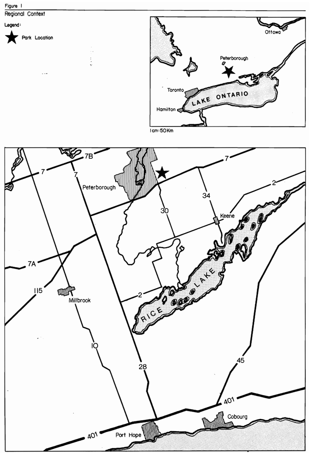
Mark S. Burnham Provincial Park (hereafter referred to as Mark S. Burnham, Burnham Woods, or the park) is located in one of the prime outdoor recreation areas for the Province of Ontario, namely the Kawartha Lakes Region. This region’s recreational potential is based on its landscape aesthetics, water and land-based recreational opportunities and its proximity to Metro Toronto and other urban centres to the south. As well, the park is located directly on the Trans-Canada Highway (Highway #7), a major transportation link between Toronto and Ottawa.
More specifically, Mark S. Burnham is located just outside of the southeast corner of the City of Peterborough, in the Township of Otonabee, County of Peterborough (see Figure 1). The park is approximately 135 km northeast of Metro Toronto.
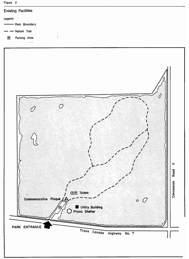
The park is a small public open space, not staffed and consisting primarily of a woodlot of approximately 39 hectares of mature forest (see Figure 2). Development has been limited to a day-use parking lot, picnic area and nature trail. In spite of its size and limited recreational opportunities, the park is popular. In 1979, during the period from May 14 to October 10, 8,563 vehicles were recorded, with an estimated total of approximately 22,000 visitors.
This land was donated to the Province of Ontario in the1950's, by the descendants of the Honourable Zaccheus Burnham, a judge from the Town of Cobourg, who originally acquired the land in the 1830's. From the 1830's to present day, the woodlot has not been substantially disturbed, except for the removal of fuelwood for the needs of the Burnham family.
Burnham Woods, as the park is locally called, has a reputation as a natural forested area with notable spring and fall bird migrations, many nesting species of birds, a mammal population representative of the area and an impressive display of spring and summer wildflowers. As well, the park contains outstanding large specimens of native tree species, many of which are over 200 years old (see Mark S. Burnham Provincial Park Background Information Document for more details).
Being located on the Trans-Canada Highway, many travellers make use of the park as a quiet roadside rest area. As well, the park’s natural environment attracts naturalists and organized school and social groups from the City of Peterborough.
It is for the purpose of planning and management of the park’s natural resources and day-use recreational facilities, that this management plan is being prepared.
2. Summary of significant issues and policy decisions
This woodlot will be allowed to naturally evolve, with little management, for interpretive, educational and research purposes. (For management exceptions, see Section 4.2 Vegetation Management.) Zoning of the woodlot as nature reserve, will reinforce the natural evolution management objective. Though the majority of the park is zoned nature reserve, the woodlot’s level of significance does not permit the park being classified as a nature reserve park (see Section 3.1).
3. Park policies
3.1 Park classification
It is recommended that the park’s classification reman as Recreation. Although considered noteworthy, the level of significance of the park’s vegetation does not warrant nature reserve classification.
3.2 Park goal
To maintain and operate Mark S. Burnham as a day-use provincial park with a limited variety of recreational facility development in a naturally-evolving woodlot. The original donation agreement stipulates that Burnham Woods is donated to the Ontario Department of Lands and Forests, to be perpetually maintained as a natural wooded area and to be known as Mark S. Burnham Provincial Park.
3.3 Park objectives
3.3.1 Protection objective
The protection objective of the Provincial Parks system is to protect provincially-significant elements of the natural and cultural landscape of Ontario.
The protection objective of this park is to protect the regionally-significant vegetation communities and in particular the outstanding large tree specimens found within the park from adverse forms of development.
This protection objective will be accomplished through zoning that is in keeping with the park’s goals, is sensitive to the particular resource management needs of the parks features as well as to the recreational pressures placed on these resources.
3.3.2 Heritage appreciation objective
The heritage appreciation objective of the Provincial Parks system is to provide opportunities for exploration and appreciation of the outdoor natural and cultural heritage of Ontario.
The heritage appreciation objective of this park is to provide an opportunity for the exploration, interpretation and appreciation of the regionally-significant vegetation resources of the park. Interpretive facilities will be sensitive to the resources' required level of protection.
3.3.3 Recreation objective
The recreation objective of the Provincial Parks system is to provide provincial park outdoor recreation opportunities ranging from high-intensity day use to low-intensity wilderness experiences.
The recreation objective of this park is to provide and encourage opportunities for outdoor recreation (day use only). These opportunities will be provided through self-serve facilities that are compatible with the park’s resources and its limited land base.
According to the Lindsay District Land-Use Guidelines:
- the park’s 30 picnic tables are estimated to represent 1.2% of the district’s picnicking opportunities to the year 2000 (they presently provide 2.4% of the district’s picnicking opportunities)
(N.B.)The difference in picnicking percentile opportunities between present day and the year 2000, represents an estimated increase in the number of similar opportunities to be made available elsewhere and does not reflect any proposed decrease in facility-based opportunities at Mark S. Burnham.
3.3.4 Tourism objective
The tourism objective of the Provincial Parks System is to provide Ontario’s residents and out of-province visitors with opportunities to discover and experience the distinctive regions of the Province.
The tourism objective of this park is to provide Ontario’s residents and out-of-province visitors, travelling along the Trans-Canada Highway with opportunities to stop enroute and picnic and hike in a natural wooded setting.
In 1979 the park was annually contributing approximately $16,000 a year to the provincial economy through park expenditures and tourist spending. It is the objective of the ministry to maintain and possibly increase the economic contribution of this park to the local economy.
3.4 Zones and zone policies
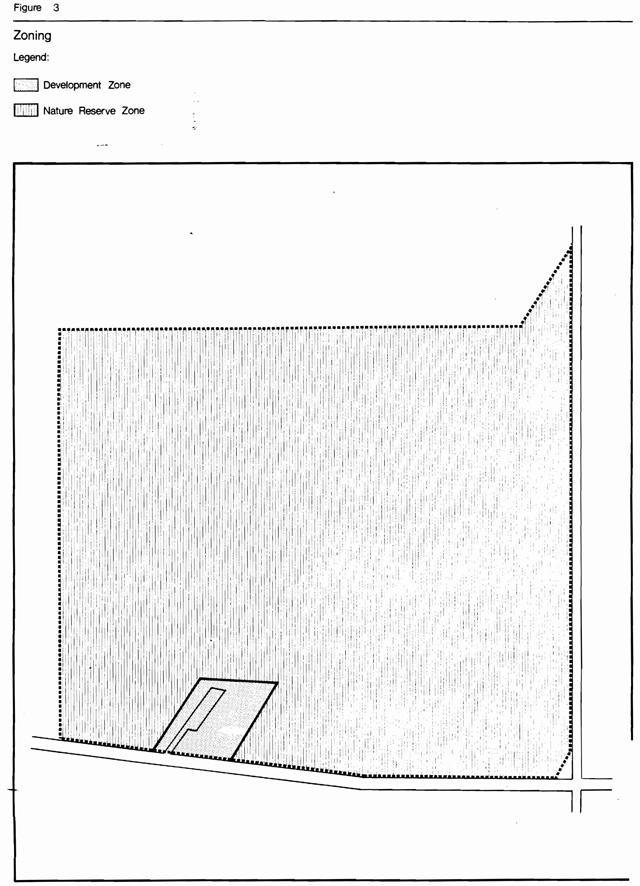
All lands within the park will be zoned (see Figure 3)in recognition of their environmental qualities, required protection and their potential for recreation and interpretive use within the context of the four objectives (see 3.3 Park Objectives)•
3.4.1 Nature Reserve Zone (38 ha)
- This zone includes the entire park, except for day-use picnic area.
Nature Reserve zone policies
- To protect, in perpetuity, the resource in its natural state. That is, to allow most natural processes to occur without manipulation or management by man. (For exceptions, see Section 4.2 Vegetation Management.)
3.4.2 Development zone (1 ha)
- This zone, adjacent to the Trans-Canada Highway, provides a parking lot, picnicking facilities, as well as a staging area for use of the Nature Reserve Zone.
Development Zone Policies
- To basically maintain the present level of development, allowing only for improvements of facilities, as needed.
4. Resource management
4.1 Landform management
- Sand and aggregate extraction will not be permitted within park boundaries.
4.2 Vegetation management
- The vegetation communities of the park will be allowed to evolve naturally with a minimum of management.
- Management involving the removal of trees and/or limbs that are safety hazards along the nature trail will be acceptable.
- Insects and diseases which do not threaten the existence of the plant communities will be allowed to continue undisturbed. Where control is desirable, it will be directed as narrowly as possible to the specific insect or disease so as to have minimal effects on other components of the park’s environment.
- Only native plant species will be planted in the development zone.
- The picking of herbaceous plants (e.g., wild leeks) is not permitted and will be discouraged.
4.3 Wildlife management
- Allowing over mature, dead and dying trees to remain as they naturally occur, except for situations where a safety hazard exists, may be beneficial to some wildlife species.
- Animal control, if necessary, may be carried out under the strict supervision of or directly by the Ministry of Natural Resources.
5. Client services management
5.1 Visitor Services
As a small provincial park, with regionally-significant life science features, a low-keyed basic level of visitor service is provided. The level of service is self-use and there will be no visitor services staffing. This park is the responsibility of the Lindsay District Office. During the summer season, Serpent Mounds Provincial Park will provide maintenance and operating functions for Mark S. Burnham.
Wherever possible, cooperative programs between the naturalist' club and the ministry will be encouraged. Of the four visitor service components (communication, recreation, outdoor education and interpretation), the former three are emphasized at this park.
5.1.1 Communication
Objectives of this component should include the following:
- informing visitors about the park, its services, facilities and management concerns
- informing visitors about recreation and interpretive opportunities in the local area
- informing visitors of the role of the Ministry of Natural Resources
- instilling a sense of respect in visitors for the park environment
- providing a means of feedback for visitors to communicate with the Ministry
The objectives outlined above will be achieved through all or some of the following: publications, signage, displays, mass media and personal contact.
5.1.2 Recreation
Passive day-use recreation (e.g., picnicking, hiking) will be emphasized because of the park’s limited land base and because of its popular use as a short-term stopover roadside picnic area.
The park will provide self-use picnicking and trail facilities.
5.1.3 Outdoor education
Local and regional school boards will be encouraged to make educational use of the park’s resources.
5.1.4 Interpretation
The following is a list of themes that will be interpreted through a combination of brochures, signs, displays and trails.
- Maple-Beech Forest
- The plant communities and the outstanding specimen trees.
- Spring wildflowers
- Peterborough Drumlin Field
- The drumlin in the park, its relation to the entire Peterborough Drumlin Field, and the dynamics of glaciation.
- Park History
- Zaccheus Burnham’s original deed to this Crown land, and subsequent owners.
5.2 Recreation management
- Year-round use of the park is encouraged.
- Serpent Mounds Provincial Park administers the park through regular maintenance, garbage pickup and spot security.
- Snowmobiles and all-terrain vehicles will not be allowed in the park. For such a small park, cross-country skiing and snowshoeing are the preferred trail activities.
- Activities compatible with the park environment will be allowed as the district parks and recreation section deems suitable within the objectives of the management policies of the Provincial Park system.
5.3 Marketing
Marketing and promotional initiatives will be implemented in order to increase the use of the park by school groups, naturalist groups and organized social groups.
6. Development
There are no plans for any further development of facilities at the park. Development will be limited to maintaining and upgrading existing facilities as required.
7. Public consultation
Public consultation during the management planning process for Mark S. Burnham focused on the local area and included the following:
- a news release and advertisement in the Peterborough Examiner, Lindsay Post and Lindsay This Week advising that a management plan was available for review at the district office
- copies of the plan forwarded to local levels of government for review (City of Peterborough, Township of Otonabee, Otonabee Region Conservation Authority)
- copies of the news release sent to interest groups (Peterborough Field Naturalist Club, Federation of Ontario Naturalists, Ontario Federation of Anglers and Hunters)
All comments and suggestions, received from the public, were considered while finalizing this plan.
This management plan will be reviewed when major issues surface and at least once within the next ten years. Any necessary plan amendments will be made with public involvement in accordance with apparent needs.
8. References
Burnham Woods Flora Group. The Flora of Burnham Woods.
Crowe, McKay, Baker. 1977. The Tourist and Outdoor Recreation Climate of Ontario, Volumes l, 2 and 3, 1977, Fisheries and Environment Canada.
Lindsay, K.1983. Evaluation of Life Science Significance of Mark Burnham Provincial Park, 1983, Ontario Ministry of Natural Resources.
Ministry of Natural Resources; Lindsay District Land Use Guidelines,1983.
Ministry of Natural Resources; Mark S. Burnham Provincial Park Management Plan, Background Information Document, 1983.
Phillips, W. J.; Ecological Survey of the Mark S. Burnham Provincial Park, 1972, Ontario Department of Lands and Forests.
White, David; International Biological Program, Checksheet for Mark S. Burnham Provincial Park, 1972.