Mattagami River Beach and Aeolian Deposit Provincial Park Management Statement
This document provides policy direction for the protection, development and management of Mattagami River Beach and Aeolian Deposit Provincial Park and its resources.
Interim Management Statement
2007
Approval statement
I am pleased to approve this Interim Management Statement for Mattagami River Beach and Aeolian Deposit Provincial Park (P1568). Ontario’s Living Legacy Land Use Strategy (OMNR 1999) designated this area as a nature reserve provincial park. Mattagami River Beach and Aeolian Deposit Provincial Park was regulated in June 2003 (O. Reg. 210/03) under the Provincial Parks Act.
This Interim Management Statement provides direction for the protection and custodial management of Mattagami River Beach and Aeolian Deposit Provincial Park.
Signed by:
Paul Bewick
Zone Manager
Northeast Zone
Ontario Parks
Date: January 19, 2006
1.0 Introduction
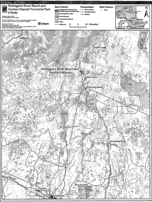
Mattagami River Beach and Aeolian Deposit Provincial Park is located in Kipling and Harmon townships, approximately 100 kilometres north of the Town of Kapuskasing and four kilometres north of Smoky Falls (Figure 1). The park is located between the Harmon and Long Rapids hydro dams on the Mattagami River.
This provincial park is located on the boundaries of the Ontario’s Living Legacy Planning Area and the Area of the Undertaking (AOU) for MNR's Forest Management Class Environmental Assessment (Forest Class EA) (OMNR 2003).The Harmon and Kipling township line acts as this boundary.
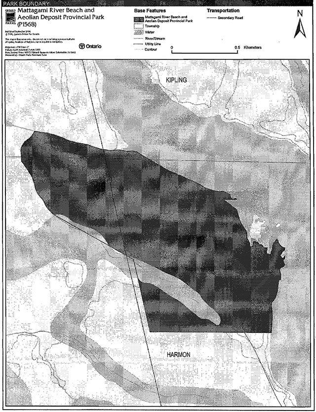
This provincial park was designated through Ontario’s Living Legacy Land Use Strategy as a nature reserve provincial park. Nature reserve class provincial parks contribute to the Ontario provincial parks system by representing the distinctive natural habitats and landforms of this part of the Province, and may provide opportunities for education and research to benefit present and future generations. Mattagami River Beach and Aeolian Deposit Provincial Park was regulated to include 164 hectares of Crown land in June of 2003 (O. Reg. 210/03) as a provincial park, nature reserve class, under the Provincial Parks Act (Figure 2).
1.1 Objectives
The park will be managed consistent with the two main objectives for nature reserve class provincial parks:
Protection: To protect provincially significant elements of the natural and cultural landscapes of Ontario.
Heritage Appreciation: To provide opportunities for exploration and appreciation of the outdoor natural and cultural heritage of Ontario.
2.0 Management context
The purpose of this Interim Management Statement (IMS) is to provide direction to ensure the custodial management of park resources. Future park planning may be undertaken as required to provide direction on significant decisions regarding resource stewardship, development, operations and permitted uses. ·
Park management will follow direction from:
- Provincial Parks Act (OMNR 1990)
- Ontario’s Living Legacy Land Use Strategy (OMNR 1999) and policy clarification amendments (OMNR 2000) and related direction
- Ontario Provincial Parks Planning and Management Policies (OMNR 1992)
- Ontario’s Crown Land Use Policy Atlas (OMNR 2004a)
In addressing custodial management obligations to protect park values and ensure public health and safety, Ontario Parks will ensure that policy and Environmental Assessment Act (1990) requirements are implemented.
Figure 1: Regional Setting
Enlarge figure 1: Regional Setting
Figure 2: Park Boundary
Enlarge figure 2: Park Boundary
2.1 Environmental assessment
As part of the Ontario Ministry of Natural Resources (MNR), Ontario Parks is a public sector agency that is subject to the Environmental Assessment Act. Management of this park will be carried out in accordance with legislation, policies and MNR's A Class Environmental Assessment for Provincial Parks and Conservation Reserves (OMNR 2005).
3.0 Park features and values
This small provincial park achieves minimal representation targets for treed bog (conifer swamp) and dense coniferous forest on glaciomarine deposits (Morris 2004).
3.1 Geological features
The bedrock of Mattagami River Beach and Aeolian Deposit Provincial Park is in the northeast extremity of the Quetico Subprovince, in the Archean Superior Province. The park is predominantly underlain by migmatites metasedimentary/ metaplutonic complex. This complex consists of biotite-quartz feldspar and hybrid granite gneisses (Frey and Duba 2002).
Information on the surficial geology of this park is limited. The Quaternary glacial deposits of the park are likely late Wisconsinan in age. Field work determined that the predominant landform in the park is actually a glaciomarine delta, not beach and aeolian deposits as the official name implies (Kor and Kristjansson, in prep.). Unusual large, crescent-shaped features are present in the wetland located in the southwest corner of the park. These features are regionally significant as they represent rare geomorphic features of the late Wisconsinan Stage of the Quaternary Period in northeast Ontario (Frey and Duba 2002).
3.2 Biological features
This nature reserve is dominated by black spruce and black spruce-larch conifer swamps on shallow organic deposits which overlie glaciomarine deltaic sediments. A few isolated stands of Jack pine are located on well drained soils; however most of the Jack pine was harvested within the park in the 1990's. The principal regenerating tree species in the clearcut areas are white spruce and white birch. Poplar-Jack pine-black spruce mixed-woods occur on the east-facing slopes along the Mattagami River (Morris 2004).
Other features include a good representation of a Northern Ribbed Fen in an old delta fan channel scar and a riparian tall shrub thicket swamp on the shores of the Mattagami River (Morris 2004).
Six significant landform/vegetation representations are known to occur within this park. Significant forest representations include dense coniferous forest, mixed forest (mainly deciduous), and sparse deciduous forest on glaciomarine deposits. Wetland representations within the park include open fen, treed bog (conifer swamp), and dense coniferous forest on thin organic deposits which cover glaciomarine drift (Morris 2004).
3.3 Cultural setting
A detailed survey and analysis of the cultural heritage of this park has not been completed.
Any future planning will be within the context of a provincial framework, A Topical Organization of Ontario History (OMNR 1974). In addition, updates and discussions with First Nations, other agencies and stakeholders may be carried out to identify cultural heritage values and features within the park and their significance. This information may be used to develop management guidelines to conserve and protect representative archaeological and historical values and features, or to provide direction for further research.
3.4 Recreation
Recreation activity within this park is limited (Carré, 2002).
The water levels along the portion of the Mattagami River adjacent to the park are susceptible to rapid fluctuation due to the operation of hydro-electric dams in the vicinity of the park. Hence, canoeing and boating along this section of the river is not recommended. Fishing is permitted, however there are no waterbodies in the park (Carré, 2002).
Nature appreciation, interpretive, and day-use activity could be supported within this park.
4.0 Aboriginal uses
The park is located within Treaty #9 (1905).
First Nations have expressed interest in and have shared knowledge of the park and surrounding area. Aboriginal communities have used the area for hunting, trapping, fishing, gathering and travel. These uses may continue, subject to public safety, conservation and other considerations.
Any communications and cooperation between Aboriginal communities and the MNR for planning and operations purposes will be done without prejudice to any future discussions or negotiations between the government of Ontario and Aboriginal communities.
5.0 Stewardship policies
5.1 Terrestrial ecosystems
The removal, damaging or defacing of Crown property, natural objects, relics and artifacts is not permitted in provincial parks (Provincial Parks Act).
Non-native species will not be deliberately introduced into the park. Where non-native species are already established and threaten park values (i.e., has become invasive), a strategy to control the species may be developed (OMNR 1992).
5.1.1 Vegetation management
Harvesting
Commercial forest operations are not permitted within the park (OMNR 1992; 2004a).
The harvest of non-timber forest products such as club moss, Canada yew etc. will not be permitted within the park.
There is no existing authorized wild rice harvesting within the park. New operations will not be permitted.
There are no fuel wood cutting permits currently issued within the boundaries of Mattagami River Beach and Aeolian Deposit Provincial Park. No new permits will be issued (OMNR 2000).
Insects and disease
Insects and diseases may be managed where the aesthetic, cultural, and/or natural values of Mattagami River Beach and Aeolian Deposit Provincial Parare threatened (OMNR 1992).
Control measures will follow guidelines established by the Ontario Ministry of the Environment (MOE) and MNR. Whenever possible, biological controls will be given preference over the use of chemicals (OMNR 1992).
Fire
The park is located within the Northern Boreal (Kipling Township) and the Boreal (Harmon Township) fire management zones. In accordance with existing provincial park policy and the Forest Fire Management Strategy for Ontario (OMNR 2004b), and due to the small size of the park, forest fire protection will be carried out in this park as on surrounding lands.
Whenever feasible, MNR's Forest Fire Management program will use techniques which minimize damage to the landscape, such as limiting the use of heavy equipment or limiting the number of trees felled during response efforts (OMNR 2004b).
5.1.2 Wildlife Management
The park is located in Wildlife Management Unit (WMU) 24. The removal and harassment of non-game animals is not permitted in provincial parks (Provincial Parks Act).
Hunting
Hunting is not permitted within nature reserve parks (OMNR 1992; 1999; 2000; 2004a).
The harvest of bullfrogs or snapping turtles is illegal in provincial parks.
Bear management areas
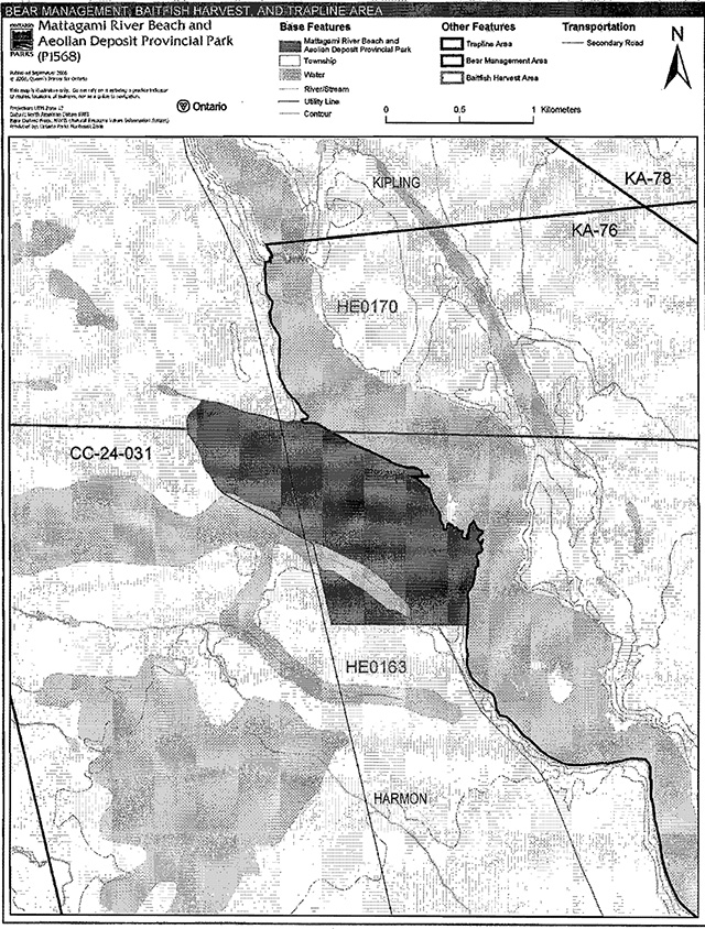
One bear management area (BMA) overlies the park boundary: CC-24-031 (Figure 2). This BMA is currently allocated for harvesting.
Hunting, including commercial bear hunting, is not permitted in nature reserve parks (OMNR 1992, OMNR 1999, OMNR 2000). The portion of the BMA that is located within the regulated park boundary will be removed from BMA CC-24-031 (OMNR 2004a).
Trapping
The park falls within trap line KA-76 (Figure 2).This trap line is currently allocated for use.
The portion of the trap line within the regulated park boundary will be removed from the trap line license. No new operations will be permitted within the park boundary (OMNR 2004a). If a commercial license is revoked or surrendered, all portions of the registered trap line within the park will be rescinded from the trap line’s legal description (OMNR 1992; 2000).
5.1.3 Industrial resources
Commercial mineral exploration and extraction, sand and gravel extraction, and peat development are not permitted within the park (OMNR 1992, OMNR 2004).
All Crown land within the park has been withdrawn from mining activity under the authority of the Mining Act (1990).
5.1.4 Access and crossings
Access and roads
The park can be accessed via Smoky Line Road, which passes through the centre of the park. Smoky Line Road branches off Fred Flatt Forest Access Road north of the Town of Kapuskasing.
The Smoky Line Road crosses through the park and continues north (Figure 2). The corridor of this road is not excluded from the park. There are no other roads located within this park.
New roads will not be permitted within the boundary of this nature reserve (OMNR 2004).Where existing roads are essential for continued access beyond the nature reserve for access, forest management or recreation purposes, and alternative road access does not exist, or road relocation is not feasible, existing roads will continue to be available for access (OMNR 2004). Continued use will include maintenance and may include upgrading (OMNR 2004).
Ontario Parks is not responsible for the maintenance or upgrading of any roads within the park.
Utility corridors
There is one hydro line corridor that crosses through the centre of the park. The corridor of this utility line is not excluded from the park boundary.
Maintenance of these existing utility lines will be permitted. These activities must adhere to the regulations set out under the relevant acts, such as the Environmental Assessment Act, the Canadian Environmental Protection Act (1999) and the Pesticides Act (1985). Maintenance activities shall not impact negatively on the values being protected within this park.
All public utilities (e.g., gas pipelines, transmission lines, communications towers, etc.) must avoid park lands wherever possible. New utility corridor crossings may be necessary to maintain essential public services (OMNR 2004a).
Any future utility corridors proposed through the park, where park lands are unavoidable, will be reviewed on a case-by-case basis. Protection of park features and values will be priority and all requirements of the Environmental Assessment Act will be met.
Recreational trails
There are currently no authorized trails within the park. New trails (e.g. hiking trails) may be developed, if the need arises, during park management planning, with full public consultation. Any proposed development within Mattagami River Beach and Aeolian Deposit Provincial Park is subject to Environmental Assessment Act requirements.
5.1.5 Adjacent land management
Forestry
South of the Harmon-Kipling township line, and on the west side of the park boundary, is the Gorden Cosens forest management unit (FMU). This FMU is currently managed by Spruce Falls Incorporated.
Crown land north of the Harmon-Kipling township line is outside of the AOU for MNR's Forest Management Class Environmental Assessment (Forest Class EA). This Crown land is included in the Northern Boreal Initiative (NBI). The goal of the NBI is to provide northern Aboriginal communities with opportunities to take a leading role in the development of new, sustainable commercial forestry opportunities.
General use area
The Kapuskasing Resource Extraction Area is the only general use area located adjacent to the park boundary.
The Kapuskasing Resource Extraction Area (G1736) is 1,410,036 hectares in size. There is mineral potential in the area: metavolcanic rock (gold, silver and base metals) in the are located in the southeast and cretaceous sediments cover most of the northern portion of the area. There are also forestry and peat resources in the area. The extraction and use of natural resources is the primary use of this area. Management priorities include forest management, fur management, mineral and aggregate programs. Water storage for hydro-electric power generation is also a significant priority.
5.1.6 Land disposition
There are no existing private recreational camps, cottage lots, land use permits (LUP), or licenses of occupation (LO) within the park. The disposition of land for private use or corporations within the nature reserve will not be considered (OMNR 1992; 2004a).
Land use permits. Licenses of occupation and unauthorized occupations
There are no land use permits, licenses of occupation and unauthorized occupations with in Mattagami River Beach and Aeolian Deposit Provincial Park.
Patent land
There is no patent land located within Mattagami River Beach and Aeolian Deposit Provincial Park
Boat caches
There are no authorized boat caches within this provincial park. As stated in the Provincial Parks Act, boats are not permitted to be left unattended in this park without written permission from the superintendent.
5.2 Aquatic ecosystems
Sustaining high quality water resources is fundamental to the protection of park and adjacent land values. The MOE enforces applicable legislation and regulations pertaining to water quality.
5.2.1 Water management
This nature reserve is located on the Mattagami River between two hydro-electric producing dams (Harmon and Long Rapids Dam); however, the Mattagami River is not within the park and there are no dams, water control structures, or diversions within the park, nor will any be permitted in the future (OMNR 1992).
5.2.2 Fisheries management
There are no waters with fisheries within the park boundary.
Sport and commercial fishing
Although sport fishing is permitted there are no waters with fisheries in the park.
There are no commercial fishing operations within Mattagami River Beach and Aeolian Deposit Provincial Park. No new operations will be permitted (OMNR 1992; 2000; 2004a).
Commercial baitfish harvesting
Harmon and Kipling townships are currently allocated for commercial baitfish harvesting but it is unlikely that any baitfish harvesting occurs within the park (Figure 3).
Bait fishing is not a permitted activity in this class of park. The portions of baitfish licenses with the regulated boundary of the park will be removed from the baitfish license.
Fish stocking
Fish stocking will not be considered in the park (OMNR 1992).
Figure 3: Commercial Baitfish Harvesting, Bear Management and Trap Line Areas

Enlarge figure 3: Commercial Baitfish Harvesting, Bear Management and Trap Line Areas
6.0 Operations policies
6.1 Recreation management
Future planning, with full public and Aboriginal consultation, will review direction on motorized and non-motorized recreation uses.
6.1.1 Motorized recreation
Aircraft
Aircraft landings are not permitted within the park (OMNR 2004a).
Snowmobiles
There are currently no authorized snowmobile trails within the park boundary.
Off-road use of snowmobiles is prohibited within park boundaries (OMNR 2004a).
All-terrain vehicles
There are currently no authorized all-terrain vehicle (ATV) trails within the park.
The off-road use of ATVs is prohibited within the park (OMNR 2004a).
6.1.2 Non-motorized recreation
Camping
Overnight camping and the development of campground or campsite facilities are not compatible with nature reserve policies (OMNR 1992; 2004a).
Hiking
No known hiking trails exist within the park. Unauthorized hiking trails and other non-mechanized trails may be permitted to continue unless such trails threaten park features and values, create user conflicts or raise safety and/or liability issues.
Canoeing/kayaking
Long term management direction will be determined through park management planning, which includes public and Aboriginal consultation. Existing uses may continue unless park values are threatened (OMNR 2004a).
6.1.3 Emerging recreational uses
There are emerging recreational uses for which there is no or limited policy to deal with their management (e.g. adventure racing, geocaching). The park superintendent will use legislation, policy and guidelines that are in place to manage emerging uses.
6.2 Development
No development exists within the park. Any proposed development within the park may be considered through park management planning, with full public and Aboriginal consultation.
6.3 Commercial tourism
No commercial tourism infrastructure exists within the park.
Commercial tourism is not compatible with the nature reserve park policies. No new commercial tourism dispositions (e.g. commercial LUPs) will be issued within Mattagami River Beach and Aeolian Deposit Provincial Park (OMNR 2004a).
7.0 Cultural resources
An assessment of the cultural resources in the park has not been completed at this time. Management of any cultural features and values within this park will be directed toward protection and heritage appreciation (OMNR 1992).
8.0 Heritage education
Literature and other supporting information may be developed to describe the park in the context of Ontario’s provincial park system. Boundary limits, significant heritage features and permitted uses of the waterway park may be included in park literature.
Prospective park visitors may be informed about the sensitivity and significance of park values through park literature.
9.0 Research
Scientific research by qualified individuals which contributes to the knowledge of natural or cultural history, or to environmental or recreational management, may be encouraged in the park. Ontario Parks will encourage institutions, such as universities, to undertake research projects.
All research programs will require the approval of Ontario Parks and are subject to park policy and other applicable legislation. Any materials removed from the park will remain the property of Ontario Parks.
Approved research activities and facilities will be compatible with the park’s protection objective. Any site which is affected by research will be rehabilitated as closely as possible to its original state. Environmental Assessment Act requirements will apply.
10.0 References
Canadian Environmental Protection Act, 1999.
Carré, K., 2002. Recreation Assessment: Mattagami River Beach and Aeolian Deposit Provincial Park Inventory Report - Version 1.0. Ontario Ministry of Natural Resources.
Environmental Assessment Act, 1990.
Fisheries Act, 1985.
Fish and Wildlife Conservation Act, 1997.
Frey, E. and D. Duba. 2002. P1568 Mattagami River Beach and Aeolian Deposit Provincial Park. (Draft Earth Science Checksheet). Ontario Ministry of Natural Resources.
Kor, P., and R. Kristjansson, in prep. Earth Science Checksheet for P1568, Mattagami River Beach and Aeolian Deposit Provincial Park. Parks and Protected Areas, Ontario Ministry of Natural Resources, Peterborough, ON.
Migratory Birds Convention Act, 1994.
Mining Act, 1990.
Morris, E. R., 2004. Natural Heritage Area Life Science Checksheet-Mattagami Beach and Aeolian Sand Deposit. Ontario Ministry of Natural Resources.
Ontario Ministry of Natural Resources, 1974. A Topical Organization of Ontario History. Historic Sites Branch Division of Parks.
Ontario Ministry of Natural Resources, 1992. Ontario Provincial Parks Planning and Management Policies.
Ontario Ministry of Natural Resources, 1999. Ontario’s Living Legacy Land Use Strategy.
Ontario Ministry of Natural Resources, 2000. Ontario Provincial Park Policy as Amended by the Ontario Living Legacy Land Use Strategy.
Ontario Ministry of Natural Resources, 2003. Declaration Order regarding MNR's Class Environmental Approval for Forest Management on Crown Lands in Ontario (June 2003).
Ontario Ministry of Natural Resources, 2004a. Crown Land Use Policy Atlas.
Ontario Ministry of Natural Resources, 2004b. Forest Fire Management Strategy for Ontario. Aviation and Fire Management Branch.
Ontario Ministry of Natural Resources, 2005. A Class Environmental Assessment for Provincial Parks and Conservation Reserves.
Pesticides Act, 1990.
Provincial Parks Act, 1990.
Appendix A: background information
| Name | Mattagami River Beach and Aeolian Deposit Provincial Park (P1568) |
|---|---|
| Classification | Nature Reserve |
| Ecoregion/ecodistrict | 3E-1 (Clay Belt) |
| OMNR administrative region/district | Northeast - Hearst District |
| Total area (ha) | 164 |
| Regulation date & number | June 2003 (O. Reg. 210/03) |
Representation
Earth science:
The bedrock of Mattagami River Beach and Aeolian Deposit Provincial Park is in the northeast extremity of the Quetico Subprovince, in the Archean Superior Province. The park is predominantly underlain by migmatites metasedimentary/metaplutonic complex. This complex consists of biotite-quartz feldspar and hybrid granite gneisses.
Information on the park’s surficial geology is limited. The Quaternary glacial deposits of the park are likely late Wisconsinan in age. Unusual large, crescent-shaped features are present in the wetland located in the southwest corner of the park.
Life science:
This nature reserve is dominated by black spruce and black spruce-larch conifer swamps on shallow organic deposits which overlie glaciomarine deltaic sediments. There are a few isolated stands of jack pine; however most of the jack pine has been harvested from the area in the last 10 years. The park also protects a good representation of a Northern Ribbed Fen.
Cultural resources:
There has been no examination or documentation of cultural values that may exist within the park.
Recreation & tourism:
Recreational use of this park is limited (Carré, 2002).
The water levels along the portion of the Mattagami River where this park is located are susceptible to rapid fluctuation due to the operation of several hydro-electric dams near the park. Due to this canoeing and boating along this section of the river is not recommended. Fishing is permitted within nature reserve parks; however, is not recommended due to the possible fluctuations in water levels along this portion of the Mattagami River.
Nature appreciation, interpretive and day-use activity could be supported within this park.
Hunting and trapping are not permitted in nature reserve parks.
Inventories
| Survey Level | Earth Science | Life Science | Cultural | Recreational |
|---|---|---|---|---|
| Reconnaissance | Frey and Duba 2002 | Morris 2004 | Carré 2002 |