Melgund Lake Conservation Reserve Management Statement
This document provides policy direction for the protection, development and management of the Melgund Lake Conservation Reserve and its resources.
Statement of Conservation Interest
June, 2003
Dryden District
Ministry of Natural Resources
Approval statement
We are pleased to approve this Statement of Conservation Interest for the Melgund Lake Conservation Reserve (C2311).
This Statement of Conservation Interest will provide guidance for the management of the Conservation Reserve and form the basis for ongoing monitoring of activities. More detailed direction is not anticipated at this time. Should significant facility development be considered or complex issues arise requiring additional studies, more defined management direction, or special protection measures, a more detailed Conservation Reserve Management Plan will be prepared with full public consultation.
The Melgund Lake Conservation Reserve will be managed under the jurisdiction of the Wabigoon Area Supervisor, Dryden District, Ministry of Natural Resources.
Signed by:
R.G. McColm
Dryden District Manager
Ministry of Natural Resources
Date: June 30, 2003
Signed by:
Charlie Lauer
Regional Director
Northwest Region
Ministry of Natural Resources
Date: March 7, 2016
1.0 Background information
The purpose of this document is to identify and document the natural heritage values of the Melgund Lake Conservation Reserve, the activities that occur there and, through a set of management guidelines, lay out the activities that will and will not be permitted. For more information regarding this Statement of Conservation Interest (SCI) please refer to the "Conservation Reserve Policy and Procedure PL3.03.05".
Table 1.1: Background information for the Melgund Lake Conservation Reserve.
| Name | Melgund Lake Conservation Reserve (C2311) |
|---|---|
| Site region / site district | 4S-3 |
| OMNR administrative region / district / area | Northwest Region / Dryden District / Wabigoon Area, Wabigoon Forest |
| Total area (ha) | 1,094 |
| Regulation date | Anticipated for 2003 |
| First Nations | Wabigoon Lake Ojibway Nation, Eagle Lake First Nations |
| OBM | 15550054900, 15540054900, 155550055000, 15540055000 |
| Lat. /Long. | 49° 38 / 92° 19 |
| Basemap | 54550, 55550, 54549, 55549 |
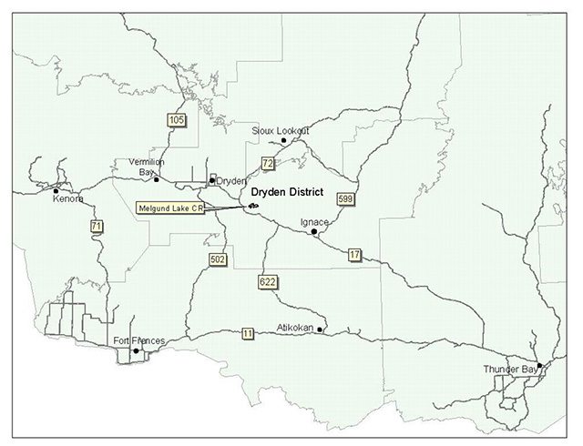
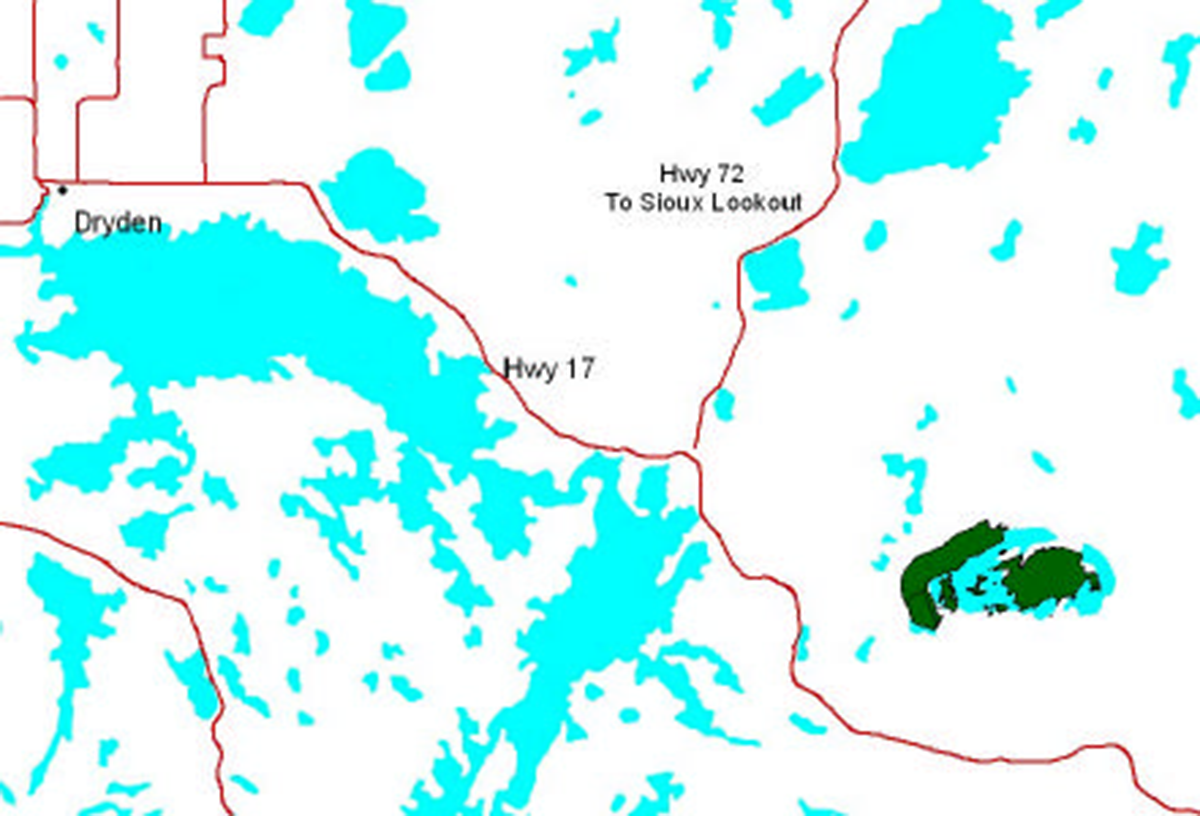
| General location description | Located approximately 40 kilometers southeast of the City of Dryden on Melgund Lake. |
| Access | Accessible on the north end of Melgund Lake via Avery Lake. West Rd. from Melgund Rd., off of Hwy. 72. Accessible on the south end of the lake via Melgund Rd. 3 off of Hwy. 17. |
Table 1.2: Representation Targets – A summary of earth science, life science, cultural resource values and present or possible recreational opportunities.
| Life science representation |
Upland Forest/Forested Dunes: Red and white pine on shorelines and as minor component of mixedwood Wetland: Animal Species: moose, bald eagle, loon, beaver, sandhill crane, pileated woodpecker, ermine |
|---|---|
| Earth science representation |
Bedrock: Surficial Geology: |
| Cultural value representation | Modern man-made structures for shore lunching and camping. |
| Recreational opportunities | Opportunity exists for fishing, summer camping activities, shore lunch activities, hunting and trapping. |
Table 1.3: Survey Information – Overview of inventories completed, their level of detail and any inventories that are needed.
| Survey level | Life science | Earth science | Cultural | Recreational |
|---|---|---|---|---|
| Reconnaissance | - Life Science Checksheet, 2002 | - Earth Science Checksheet, 2002 | - not required | - Recreation Checklist, 2002 |
| Detailed | - not required | - not required | - not required | - not required |
Figure 1: General location of the Melgund Lake Conservation Reserve.
Enlarge figure 1: General location of the Melgund Lake Conservation Reserve
2.0 Values to be protected
This section provides a description of the key natural heritage values on the site, their condition relative to past resource and management activities, and their sensitivity to future land use and management activities.
Table 2.1: Values identified on the Melgund Lake Conservation Reserve.
| Life science | two bald eagle nests, well-known walleye fishery |
|---|---|
| Earth science | the single phase, granitic stock stock is considered regionally significant |
| Cultural | fire pits, pole-wood framework, table/benches, outhouses |
| Aboriginal | N/A |
| Tourism | 4 commercial boat caches exist on Melgund Lake |
| Recreational fishing | permitted; Melgund Lake is a popular summer walleye fishery |
| Recreational hunting | permitted; WMU #5 |
| Trapping | permitted; active trap line – DR03N02401 |
| Bear Management Area | DR-05-070 |
| Bait harvesting | Block #496922 |
| Commercial fishing | past commercial fishing (1981/82) on Melgund Lake; experimental licenses issued only |
2.2 Values to be protected
The intent of this SCI is to protect the following values by establishing management guidelines for existing and potential uses in this area given the level of past disturbance and the nature of the existing features.
2.2.1 Forest values
Melgund Lake CR is considered regionally significant and contains the upland forest component absent in Pyatt and Adair Lake CRs. The red and white pine were considered to be possibly the best representation in the protected areas in Ecodistrict 4S-3. (Harris et al, 2002)
2.2.2 Biological values
The sport fish (specifically walleye) contained within Melgund Lake are considered to have a high biological and recreational value, however, the lake itself is not within the reserve. Numerous fish related programs have been conducted over the past 30 years including most recently, Fall Walleye Index Netting (FWIN) in 1997. Unfortunately, the data collected from the FWIN has not been interpreted to date. Thus, current recommendations and the status of the walleye fishery remain unknown.
Additionally, two bald eagle nests are contained within the reserve. Although this is a locally common bird, it is listed as a species at risk provincially.
2.2.3 Landform values
The reserve is centered on a granitic stock located in the northeast portion of the Eagle-Wabigoon-Manitou lakes greenstone belt. It is a single phase intrusion composed mainly of quartz monzonite. This stock is considered to be of regional significance. (Blackburn, 2002)
2.2.4 Recreational values
The shoreline features, structural features (man-made), general wildlife and mixed coniferous/deciduous forests were considered all to be recreation features. Melgund Lake, sport fish and sand beach were also considered recreation features although not directly within the reserve. Current activities enjoyed within the Melgund Lake Conservation Reserve include shorelunch and camping activities, hunting and trapping. Fishing does occur on Melgund Lake, however the lake itself is not within the reserve. Potential exists for nature activities such as identifying wildlife and relaxation. The shoreline, particularly areas in which man-made structures are contained, is considered to have a low sensitivity to recreation use. This is, in part, due to the extensive use of the sites and the potential for waste being left behind.
2.2.5 Tourism values
Currently, four commercial boat caches exist on Melgund Lake, however, these are not within the reserve boundaries.
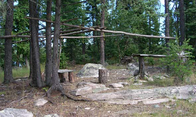
Figure 2: Campsite/shore lunch area on one of the islands within the reserve.
3.0 Management guidelines
3.1 Land tenure
The Melgund Lake Conservation Reserve consists entirely of Crown land. Patent land exists south of the reserve. Melgund Lake Forest Reserve (F2311) exists within the conservation reserve and encompasses a 102 ha parcel of land. See Appendix A for forest reserve (FR) location. Policy governing FRs are similar to that of CRs except that mining and related access will be allowed in a FR where a mining claim or lease already exists. Aggregate extraction is not permitted except where:
- there is an existing aggregate permit; as is the case with F2311
- aggregate is required to support mineral exploration or mining within the FR and there are no feasible sources outside the reserve; or
- an aggregate permit is required under the Aggregate Resources Act for the production of industrial minerals and building stone
The conservation reserve will remain Crown land and no dispositions (including Land Use Permits or Licenses of Occupation) will be issued for the site.
The disposition of adjacent Crown Land will be dealt with on a case-by-case basis.
Unauthorized occupations of lands within the conservation reserve will be handled in accordance with approved policy, and any required structural removal will be at the owner’s expense.
3.2 Existing and proposed development
Natural Resource Values Information System (NRVIS) shows there being 3 tertiary roads running into the peninsula of the reserve. These were probably used for historical selective red and white pine harvest (Harris et al, 2002). At present, they are grown over and are impassable. Cutovers and logging roads can be found in the surrounding areas. There are numerous timber harvest blocks just north of the Melgund Lake Road, scheduled for harvest in the next 5 years (2003-2008). The parcel of land surrounding the large active quarry in the southwest portion of the reserve has been deemed a forest reserve. Several other active, as well as inactive, pits can be found in the surrounding areas.
Facility infrastructure and development for recreational and/or educational purposes only may be considered in the future if there is a demonstrated demand for such facilities. All provincial policies that guide development on Crown Land are applicable in Conservation Reserves. A more detailed management plan would be required prior to any development occurring. Such a plan would have to ensure that there would be no negative impacts to any habitat or ecosystem pertinent to the values protected in this reserve.
3.3 Recreational activities
Most recreational activities that have traditionally been enjoyed in this area can continue provided they pose no threat to the natural ecosystems and features protected by the Conservation Reserve. Those uses that are regulated include hunting, fishing and trapping. Most other permitted activities are non-regulated (i.e. canoeing, exploring, snowmobiling). See Section 2.2.4 for the recreational uses for this Conservation Reserve as determined by the Recreation Resource Inventory.
It is recommended that sites containing man-made structures be monitored, due to the accumulation of human waste during shore lunch and camping activities.
Recreational boat caches will continue to be a permitted use. New applications will be reviewed subject to a test of compatibility with the conservation of the ecological features of the site. In most cases, the location of the new boat caches will be located outside of the CR. In addition, the Northwest Region Boat Cache Program Guidelines will also apply.
Mechanical travel within the reserve, including the use of snowmobiles and all-terrain vehicles, is permitted only on existing roads and trails. Off trail mechanized travel is permitted for retrieval of game only.
3.4 Commercial activities
No new activities, such as commercial logging, hydroelectric power development, new transmission lines (e.g. power or communications), pipelines, highways or roads, and the extraction of minerals, aggregate or peat, will be permitted.
Experimental licenses for a Commercial Whitefish Fishery were issued in 1981 and 1982 on Melgund Lake. No commercial fishing licenses have been issued since.
Resource user boat caches for the commercial harvest of natural resources (baitfish, commercial fur and wild rice) under a valid license, will continue to be a permitted use. New applications will be reviewed subject to the test of compatibility. New commercial boat caches will not be permitted. In addition, the Northwest Region Boat Cache Guidelines will also be followed.
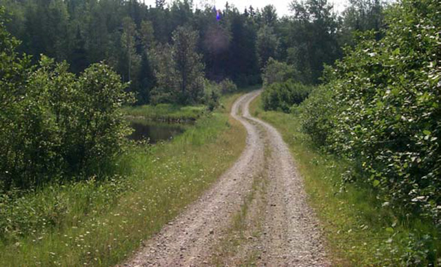
Figure 3: Tertiary road leading to north access/campsite.
An examination of the possible impact of activities on adjacent lands should be evaluated in the Forest Management Plan.
3.5 Aboriginal interests
Melgund Lake Conservation Reserve (C2311) lies within Treaty 3 area. To date, no Aboriginal Groups have voiced any issues in regard to this conservation reserve. Nothing in this Statement of Conservation Interest affects in any way existing or future Aboriginal or treaty rights.
3.6 Natural resources stewardship
Natural Resource Stewardship involves the consideration of the following specific natural resource management categories.
3.6.1 Vegetation management
Management within the conservation reserve will allow for the continuation of natural ecosystem processes and functions with minimal human interference.
Forest fire suppression will be carried out in accordance with the approved Fire Management Strategy for the surrounding lands. "Light on the Land" suppression techniques which do not unduly disturb the landscape will be encouraged where feasible. Examples of "light on the land" techniques may include limiting the number of trees felled or the use of heavy equipment or foam.
Opportunities for prescribed burning to achieve ecological or resource management objectives may be considered. These management objectives will be developed with public consultation prior to any prescribed burning, and reflected in the document that provides management direction for this conservation reserve. Plans for any prescribed burning will be developed in accordance with the MNR Prescribed Burn Planning Manual, and the Class Environmental Assessment for Provincial Parks and Conservation Reserves (approval pending).
Forest insect and disease management will continue as on surrounding Crown lands.
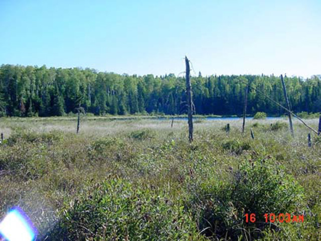
Figure 4: Wetland area contained within western section of the reserve.
3.6.2 Fish and wildlife management
The existing Wildlife Management Unit, sport fishing regulations and other fish and wildlife management activities will apply.
3.6.3 Landforms
None of the landforms mentioned will be altered by landform modification activities such as filling and extraction. The extraction of aggregates and similar materials are not permitted. As already mentioned, a large aggregate permit exists adjacent to the CR and has been designated a forest reserve. When the area is released back to the Crown through normal processes, the forest reserve will be incorporated into the Melgund Lake Conservation Reserve.
Mineral exploration and extraction are not permitted. The areas within the CR and the FR have been withdrawn from further staking by MNDM.
3.7 Cultural resources stewardship
To date, there have been no surveys done to assess cultural or heritage values. However, according to the Melgund Lake Conservation Reserve Recreation Inventory Report (2002), some cultural value has been allocated to the abundance of man-made structures (fire pits, pole-wood framework, benches/tables etc.) found throughout the reserve. No Aboriginal and/or archaeological values are contained within the reserve. Thus, further Cultural Inventories have been deemed unnecessary.
3.8 Client services
Given the focus on low key management, client information will be given on an inquiry basis only and will deal with the basic level of information with respect to access, natural heritage appreciation, recommended activities and boundaries.
3.9 Research
Non-destructive research by qualified individuals will be encouraged to provide a better understanding of the natural values protected by the Conservation Reserve and to advance protection, planning and management.
In order to assist with enhancing the management guidelines for the reserve, the collection of additional earth and life science information during research is encouraged. All research programs will require the approval of the Ministry of Natural Resources as will the removal of any natural or cultural specimen. The establishment of permanent plots, observation points or facilities must also be approved and be compatible with the Conservation Reserve protection objective. Any site disturbed by research activities must be rehabilitated as closely as possible to its previous state.
3.10 Marketing
Awareness of the Conservation Reserve is promoted through the Living Legacy web site. Intensive management activity to increase use is not required at this time.
4.0 Implementation
Implementation of this Statement of Conservation Interest will primarily involve monitoring activities to ensure adherence to the management guidelines and responding to inquiries about the site.
Implementation of this statement and management of the reserve are the responsibility of the Wabigoon Area Supervisor. Partnerships may be pursued to address management needs.
5.0 Review and revisions
5.1 Review and revisions
This Conservation Reserve Statement of Conservation Interest will be reviewed on an ongoing basis.
If changes in management direction are needed at any time, the significance of the changes will be evaluated and further consultation a possibility. Any major amendments will require full public consultation and the approval of the District Manager and Regional Director. Affected clients will be immediately informed of proposed changes to this Statement of Conservation Interest.
5.2 Public consultation
5.2.1 Results of past consultations
Consultation on the Melgund Lake Conservation Reserve was conducted as part of the consultation on the Ontario’s Living Legacy Land Use Strategy, July 1999. Subsequent consultation also took place in June 2001 to refine the boundary of the Conservation Reserve.
District Manager letters, totaling 96, were sent to the Dryden Forest Management Co., Weyerhaeuser and Ontario’s Forest Industries Association Tourist Outfitters, Advisory Committees, Trappers, Land Owners, Members of the Public, NGOs and GOs. Newspaper ads were placed in the Ignace Driftwood June 20, 2001 and Dryden Observer on June 19, 2001. First Nation Consultation letters were also sent to twelve Native communities and organizations including the Wabigoon Lake Ojibway Nation, Eagle Lake First Nation and Aboriginal People of Wabigoon. Direct consultation with Treaty 3 First Nations was carried out on a regional basis and concluded November of 2002.
Concern about the effects of the CR on aggregate extraction was voiced pertaining to the large quarry contained within the Forest Reserve. It was explained that there are provisions that state where significant mineral deposits are found with the intent to extract the deposit, the area could be deregulated and an area of equivalent size added to the Conservation Reserve. However, there was no indication that resource development would require additional area outside the present aggregate permit. A request was put in from MNR to forward any records of exploration work outside the current permit to the Regional Office in Thunder Bay. There were no additional responses. The policy on controlled exploration was later changed in March 2002. It states that there will be no new exploration on untenured land within the OLL sites. All existing mining land tenure within OLL sites including mining claims, leases, licences of occupation and patents remain protected under the Mining Act and will be treated as any others in the province.
No issues have been voiced by any of the Native groups mentioned to date.
5.2.2 Present and future consultation
More widespread consultation is deemed unnecessary at this time.
5.2.3 Author
This Statement of Conservation Interest was prepared by Alicia H.L. Morin, OLL Intern, Information Management, Dryden District. Assistance was provided by Martin Pell (Dryden District Planner) and members of the Wabigoon Area Team.
6.0 References
Blackburn, C. 2002. Earth Science Inventory – Melgund Lake Conservation Reserve. Unpublished report.
Harris, A. and Foster, R. 2002. Life Science Inventory – Melgund Lake Conservation Reserve. Unpublished report.
Ontario Ministry of Natural Resources. 1999. Ontario’s Living Legacy – Land Use Strategy. Queen’s Printer for Ontario.
Ontario Ministry of Natural Resources. 2002. Melgund Lake Conservation Reserve (C2292) Recreation Resource Inventory Report. Unpublished report.
Ontario Ministry of Natural Resources, Lands & Natural Heritage, Lands & Waters. 1997. Conservation Reserve Policy and Procedure PL 3.03.05. 22 pp.
Appendix A: Melgund Lake Conservation Reserve (C2311) values map
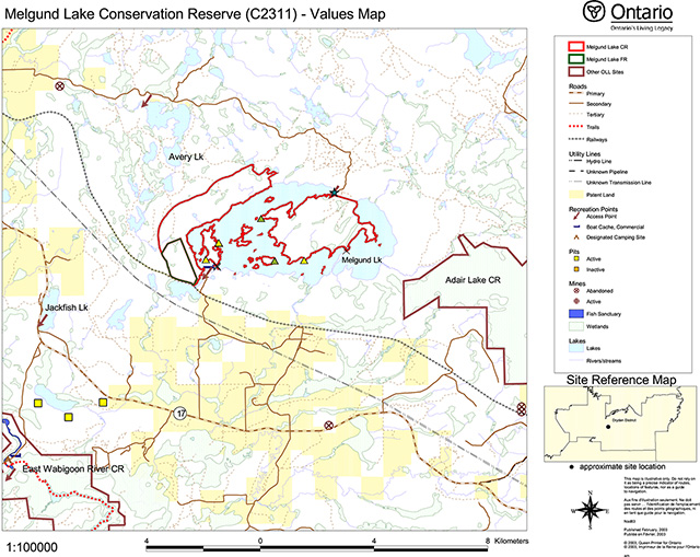
Enlarge Melgund Lake Conservation Reserve (C2311) Values Map
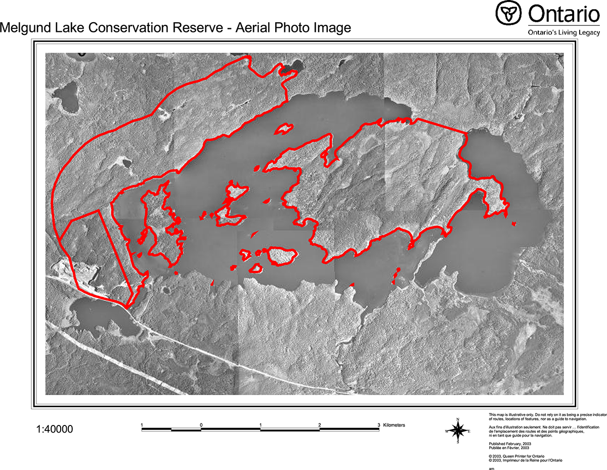
Appendix B: Melgund Lake Conservation Reserve (C2311) Aerial Photo Image
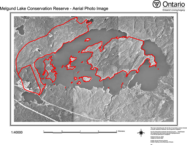
Enlarge Melgund Lake Conservation Reserve (C2311) Aerial Photo Image
Appendix C: Melgund Lake Conservation Reserve (C2311) Earth Science Checksheet
Detailed information for Site C2311 Melgund Lake
Protection history
The reserve was identified under the provincial Lands for Life - Ontario’s Living Legacy Program as containing "representative landforms and vegetation types, including burns and mixed forests on lacustrine deposits and weakly and moderately broken ground moraine." (OMNR 1999).
No other earth science significance was assigned.
Setting
The reserve comprises 1 205 hectares, and is located in Dryden MNR District. Elevations range from 410 m a.s.l. to 470 m a.s.l.
Earth science features:
Bedrock geology
Melgund Lake Conservation Reserve is centred on a granitic stock located in the northeast portion of the Eagle-Wabigoon-Manitou lakes greenstone belt (Blackburn et al 1991: figure 9.8). The greenstone belt lies within the 900 km long, Archean age Wabigoon Subprovince of the Superior Province, at its western end (Blackburn et al 1991: figure 9.2). The Melgund Lake stock is 7.6 km long by 3.6 km wide, about the same size as the lake. The north edge of the stock closely follows the shoreline, as does much of the southern shore. A large, rocky, central peninsula protruding into the lake from the northeast shore underlies the central portion of the stock. Quite likely some mechanical or mineralogical variation in the rocks of the central part of the stock is responsible for the preservation of this upland feature.
Melgund Lake stock is a single phase intrusion, composed predominantly of quartz monzonite, but varying to monzonite and diorite, particularly close to its edges (Map 2529: Berger et al 1989). Where observed at a distance from the edge (stations 3, 4, 5, 6 and 8; photo 1) it was seen to be massive, medium to coarse grained, hornblende quartz monzonite, with little variation in mineral proportions. Close to the edge, at the contact with amphibolite of the greenstone belt (station 7), the original composition is contaminated by assimilation of basalt, so that the resulting diorite is almost indistinguishable from the volcanic rocks.
Volcanic rocks of the greenstone belt that surround the stock are dominantly mafic flows (Map 2529: Berger et al 1989). These mafic volcanics were observed within the 1 km wide buffer zone at the west end of the reserve (station 1), where they are massive and metamorphosed to medium grained, dark green amphibolite. Map 2529 (Berger et al 1989) indicates that there is variation within this buffer zone from pillowed to plagioclase phyric varieties. Metamorphism to amphibolite grade was imparted by intrusion of the stock: further distant from the stock the basaltic rocks are at a lower, greenschist, grade of metamorphism.
Surficial geology
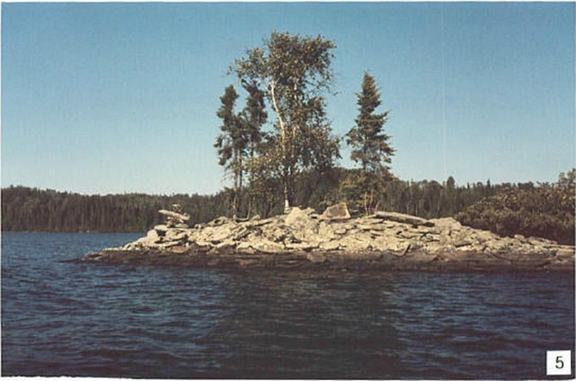
Pleistocene age, Wisconsinan stage glaciation has scoured this largely upland area, leaving shallow till over bedrock (Roed 1980; Cowan and Sharpe 1991). Record of glacial ice movement from the northeast is seen in the bedrock ridges with similar trend that occur in particular on the central peninsula (photo 2). Just outside the reserve boundary, a sinuous, narrow northeast trending peninsula that lies in the southeast part of the lake has previously been interpreted (Map 1774A: Cowan and Sharpe 1991) to be a bar or spit of lacustrine origin. However, its linear extension to the southwest of a prominent bedrock ridge on the central peninsula, plus the observation (station 2) that it is underlain not by sand but by boulders of quartz monzonite of the Melgund Lake stock, suggests that it is the crest of a glacially scoured bedrock ridge. This interpretation is supported by the observation that it is paralleled by a chain of four small bedrock islands, that are included in the reserve, about 3 to 4 hundred metres to the northwest, similarly extending from a bedrock ridge on the peninsula (photo 3).
The northwest trending Hartman end moraine lies about 5 km to the northeast of the reserve. To the southwest of the Hartman moraine sand, gravel and boulder material has been variously interpreted as glaciofluvial outwash (Roed 1980) and shallow water glaciolacustrine (Cowan and Sharpe 1991; Barnett et al 1991). Proglacial, glaciofluvial outwash material that was deposited at the edge of the retreating Wisconsinan age glacier was most likely reworked at the edge of glacial Lake Agassiz. Difficulty in distinguishing between the two types of material may account for the variability in map interpretation. Most of these materials lie to the east of Melgund Lake reserve, but small pockets that have been interpreted (Cowan and Sharpe 1991) to be glaciolacustrine lie between bedrock ridges on the southeast side of the central peninsula. Some of the shallow drift over bedrock in the reserve area may also be of this material.
Glaciolacustrine silt and clay deposits have been interpreted (Map 1774A: Cowan and Sharpe 1991) to underlie the large island at the west end of the lake. During the present inventory, shallow silt and clay was augured at station 9, to the north of the island. Other isolated pockets of glaciolacustrine deposits may be present in the reserve.
Recent organic deposits occupy a few isolated areas, one of which was observed at station 7, where a small wetland is margined by bedrock hills. A prominent recent process is the frost heaving of horizontally jointed slabs of granitic rock on islands and shoreline outcrops (station 4: photo 4 ; station 5: photo 5).
Significance
Melgund Lake stock is almost entirely enclosed in the reserve boundary. It represents a type of synvolcanic to late tectonic intrusion into greenstone belt rocks of the Wabigoon subprovince (see Table 9.9 in Blackburn et al 1991): none of these intrusions have been incorporated in their entirety under the Ontario Living Legacy program. Although other stocks of this type have been better studied, it is considered to be of regional significance. The mafic volcanic rocks marginal to the stock are typical of large areas of greenstone belts in the Superior Province of Ontario, but are not well exposed, and there is little diversity in structures and textures. They are not considered to be significant to the earth science conservation program.
None of the surficial deposits are well developed enough to be of significance. The narrow northeast trending peninsula just outside the reserve boundary was investigated to determine if it was a lacustrine bar or spit, in which case it would have had some significance. However, the interpretation that it is the crest of a submerged bedrock ridge diminishes its significance.
Sensitivity
Bedrock features are not susceptible to degradation by either human activity or natural processes. Degradation by human activity of surficial materials is considered insignificant because of their relative lack.
Recommendations
The Melgund Lake stock is not incorporated in its entirety in the reserve. However, contact metamorphic effects of the stock on the surrounding mafic volcanic rocks are adequately incorporated along its northwest edge, so that expansion is not recommended.
The present survey has adequately identified both bedrock and surficial features of the reserve. No further recommendations for inventory are made.
References
Berger, B.R., MacMillan, D. and Butler, G. 1989, Precambrian geology, Melgund Lake area, MacFie and Avery townships; Ontario Geological Survey, Map 2529, scale 1:20 000.
Blackburn, C.E., Johns, G.W., Ayer, J. and Davis, D.W. 1991. Wabigoon Subprovince; in Geology of Ontario, Ontario Geological Survey, Special Volume 4, Part 1, p. 303-381.
Cowan, W.R. and Sharpe, D.R. 1991. Surficial Geology, Wabigoon Lake, Ontario; Geological Survey of Canada, Map 1774A, scale 1:100 000.
OMNR 1999. Ontario’s Living Legacy: Land Use Strategy; Ontario Ministry of Natural Resources, 136 p., accompanied by map, scale 1:1 200 000.
Roed, M.A. 1980. Northern Ontario Engineering Geology Terrain Study, Data Base Map, Wabigoon Lake; Ontario Geological Survey, Map 5059, scale 1:100000.
Photographs
- Pink, massive, hornblende quartz monzonite of the Melgund Lake (Stn. 3; UTM 0550981E 5498808N)
- Northeasterly trending bedrock (granitic) ridge on the central peninsula of Melgund
- Extension of two granitic ridges in a sinuous peninsula (left) and islands (right) toward southwest beneath Melgund Lake
- Horizontal sheet jointing and frost heaving in granitic rocks of the Melgund Lake stock. (Stn. 4; UTM 0551655E 5499128N)
- Large scale frost heaving of sheeted joints in granitic rocks of the Melgund Lake stock on an island in Melgund Lake. (Stn. 5; UTM 0552116E 5498988N)
Photo 1: Pink, massive, hornblende quartz monzonite of the Melgund Lake (Stn. 3; UTM 0550981E 5498808N)
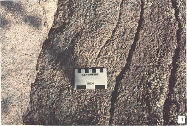
Photo 2: Northeasterly trending bedrock (granitic) ridge on the central peninsula of Melgund
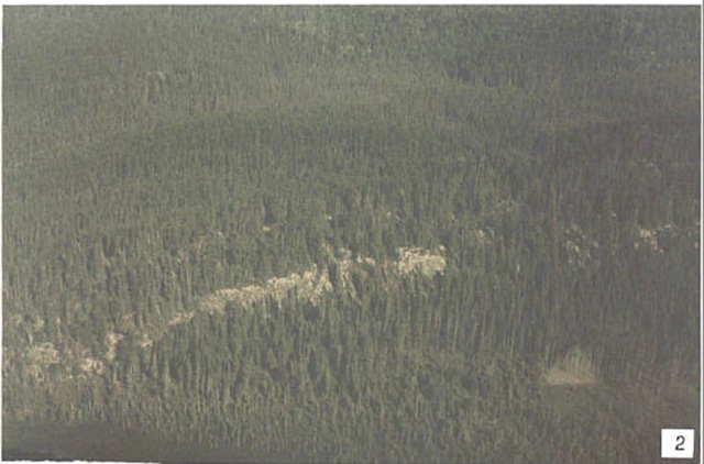
Photo 3: Extension of two granitic ridges in a sinuous peninsula (left) and islands (right) toward southwest beneath Melgund Lake
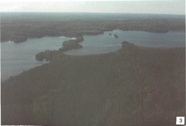
Photo 4: Horizontal sheet jointing and frost heaving in granitic rocks of the Melgund Lake stock. (Stn. 4; UTM 0551655E 5499128N)
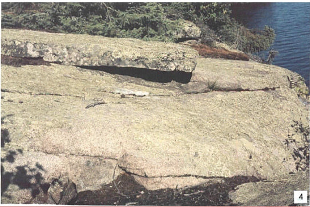
Photo 5: Large scale frost heaving of sheeted joints in granitic rocks of the Melgund Lake stock on an island in Melgund Lake. (Stn. 5; UTM 0552116E 5498988N)
Additional stations
Stn. 1 0545564E 5500016N
Stn. 2 0550459E 5498155N
Stn. 6 0548428E 5498463N
Stn. 7 0547527E 5500632N
Stn. 8 0548111E 5500537N
Stn. 9 0546158E 5499786N
Earth Science Inventory Checklist
| Name: | Melgund Lake |
|---|---|
| OLL ID: | C2311 |
| Map name: | Dyment |
| NTS Number: | 52F/09 |
| UTM reference: | Z15 549000E 549 |
| OBM Number: | |
| Latitude: | 49° 39' N |
| Longitude: | 92° 20' W |
| Elevation – Max: | 470 m |
| Elevation – Min: | 410 m |
| County: | District of Kenora |
| Township: | Avery |
| Lot: | N/A |
| Concession: | N/A |
| Area (ha): | 1,205.00 |
| Ownership: | Crown |
| Air Photo: | |
| Year – Roll – Flight line – Number: | 97-58-4922A-57to61 |
| MNR region: | Northwest |
| MNR district: | Dryden |
| Park zone: | Northwest |
Earth science features:
Archean age, Wabigoon Subprovince: Melgund Lake basin is contained entirely within and circumscribed by the outer margin of the granitic Melgund Lake stock, of which the central peninsula is the core; the 1 km. buffer zone at the west end is underlain by mafic volcanic rocks of the Manitou-Stormy lakes greenstone belt, metamorphosed to medium to high grade (amphibolites).
Quaternary: deposits are dominantly Pleistocene glaciofluvial outwash material reworked by glacial Lake Agassiz, with minor glaciolacustrine silt and clay.
Significance:
Melgund Lake stock is almost entirely contained in the reserve: it represents a type of synvolcanic to late tectonic intrusion into greenstone belt rocks. It is of regional significance.
Mafic volcanic rocks are typical of large areas of greenstone belts in Superior Province, but not well exposed and little diversity in structures and textures. Not significant.
Surficial deposits not well developed enough to be of significance.
Sensitivity:
Neither bedrock nor surficial features are sensitive to natural or cultural impacts.
Recommendations:
Although Melgund Lake stock is not entirely enclosed in the reserve, contact metamorphic effects on the surrounding mafic volcanic rocks are adequately incorporated along its western edge: expansion of the reserve is not recommended.
Major references:
Berger et al 1989, OGS Map 2529; Blackburn et al 1991, "Wabigoon Subrovince" in OGS Special Volume 4; Cowan and Sharpe 1991, GSC Map 1774A; Roed 1980, OGS Map 5059.
Date compiled:
February 15, 2003
Compiler:
C.E. Blackburn, Blackburn Geological Services
Appendix D: Melgund Lake Conservation Reserve (C2311)Life Science Checksheet
C2311 Melgund Lake
Natural heritage area – life science checksheet
| Name | Melgund Lake |
|---|---|
| Map Name | Dyment |
| Map Number | 52F-9 |
| UTM Ref. | Zone 15 549000 E 5499500 N |
| County | Kenora |
| Lat. | 49 39' N |
| Long. | 92 20' W |
| NAD | 83 |
| Min. Alt. | 410 m |
| Max. Alt. | 470 m |
| Locality | 35 km SW of Dryden |
| Township | Avery |
| Area | 1215 ha |
| Ownership | Crown |
| MNR Region | Northwest |
| Ecoregion and Ecodistrict | 4S-3 |
| Landform Unit | See Table 3 |
| MNR District | Dryden |
| Aerial Photographs | Year-Roll-Flight Line-Numbers 97-58-4922A-57 to 61 |
Life science checksheet map for Melgund Lake Conservation Reserve

Life science checksheet map for Melgund Lake Conservation Reserve
Physical and biological features
Melgund Lake Conservation Reserve encompasses 1,215 hectares, including two sections of mainland and 37 islands in Melgund Lake. The mainland blocks include a buffer on the northwestern edge of the lake, extending one kilometer inland and a large peninsula dividing the lake into two basins. There are 16 km of island shoreline and 21 km mainland shoreline. The islands range in size from less than 1 ha to 48 ha, and account for 7% of the reserve (81 ha). A 102 ha parcel in the southwest of the reserve is an active quarry and currently classified as Forest Reserve.
Melgund Lake is on a sandy to loamy deposit on the southwest edge of the Hartmann Moraine. The soil is largely glacial outwash that was subsequently reworked by Lake Agassiz. The moderately broken terrain has shallow soils with bedrock hills. Pockets of silty soil suggest that aeolian deposits have filled in depressions.
Most of the forest in the reserve is trembling aspen and black spruce mixedwood on coarse loamy soil (ES19, ES21). The understorey is rich and diverse with mountain maple, shrubby balsam fir and large-leaved aster. Trembling aspen stands (ES28) dominate on silty soils except on cool, north facing slopes where black spruce stands (ES26, ES31) are found. These stands occur more frequently than indicated in Table 1, but occur as small patches within other forest types. Jack pine and black spruce forest on shallow soils (ES12) make up 8% of the area.
Red and white pine stands are typically on lakeshores. White pine dominated forest makes up only 10% of the area, but red and white pine often occur as a minor component of mixedwood stands. Rich sites have a dense balsam fir understorey.
Most of the forest in the reserve is between 40 and 100 years old, with only three stands greater than 120 years (one stand each dominated by white pine, jack pine and black spruce). A 1999 fire at the east end of the Conservation Reserve covering 20 ha is regenerating with trembling aspen.
A diversity of wetland communities is represented in the reserve, covering about 15% of the area. Peatlands make up about 10% of the reserve, occurring where organic soil has accumulated in bedrock depressions. Open peatlands include shore fen on margins of lakes and ponds (ES45) and open bogs (ES39) in hydrological isolated basins. Treed wetlands are dominated by black spruce and tamarack (ES34, ES35, ES36). Cedar swamps (ES37) develop in peaty drainage ways supplied by nutrient-rich groundwater. The extensive areas of shallow water in Melgund Lake have bulrush marsh (ES48) in more wave-washed areas and submergent-rich communities at estuaries and sheltered bays (ES49). On shorelines, shore fens (ES45) are common on quiet bays, elsewhere; the shores are mostly forested to the edge of the water with a few exposed bedrock shelves on steeper sections.
Small patches of rock barren (ES7) occur on hilltops and a few low cliffs are found on lakeshores.
Table 1. Ecosites of Melgund Lake Conservation Reserve (derived from Forest Resource Inventory data provided by OMNR).
Non-forested terrestrial ecosites
| Description | Area (ha) | Proportion (%) | |
|---|---|---|---|
| ES7 | Rock Barren | 1 | <1 |
Very shallow soils
| Description | Area (ha) | Proportion (%) | |
|---|---|---|---|
| ES12 | Black Spruce - Jack Pine: Very Shallow Soil | 91 | 8 |
Sandy – coarse loamy soils
| Description | Area (ha) | Proportion (%) | |
|---|---|---|---|
| ES17 | White Cedar: Fresh - Moist, Coarse - Fine Loamy Soil | 3 | <1 |
| ES18 | Red Pine - White Pine: Fresh, Coarse Loamy Soil | 26 | 2 |
| ES19 | Hardwood - Fir - Spruce Mixedwood: Fresh, Sandy - Coarse Loamy Soil | 423 | 35 |
| ES20 | Spruce - Pine / Feathermoss: Fresh, Sandy - Coarse Loamy Soil | 134 | 11 |
| ES21 | Spruce - Fir Mixedwood: Fresh, Coarse Loamy Soil | 253 | 21 |
| ES22 | Spruce-Pine / Ledum / Feathermoss: Moist, Sandy-Coarse Loamy Soil | 6 | 1 |
Fine loamy – clayey soils
| Description | Area (ha) | Proportion (%) | |
|---|---|---|---|
| ES26 | Spruce - Pine / Feathermoss: Fresh, Fine Loamy - Clayey Soil | 25 | 2 |
| ES31 | Spruce-Pine / Feathermoss: Moist, Silty-Clayey Soil | 61 | 5 |
Treed wetlands
| Description | Area (ha) | Proportion (%) | |
|---|---|---|---|
| ES34 | Treed Bog: Black Spruce / Sphagnum: Organic Soil | 28 | 2 |
| ES35 | Poor Swamp: Black Spruce: Organic Soil | 41 | 3 |
| ES36 | Intermediate Swamp: Black Spruce (Tamarack): Organic Soil | 32 | 3 |
| ES37 | Rich Swamp: Cedar (Other Conifer): Organic Soil | 8 | 1 |
| ES38 | Rich Swamp: Black Ash (Other Hardwood): Organic - Mineral Soil | 3 | <1 |
Open wetlands
| Description | Area (ha) | Proportion (%) | |
|---|---|---|---|
| ES39 | Open Bog: Ericaceous Shrub / Sedge / Sphagnum: Organic Soil | 33 | 3 |
| ES44 | Thicket Swamp: Organic-Mineral Soil | 1 | <1 |
| Unknown | 15 | 1 | |
| Unclassified | 32 | 3 |
Representation
Table 3 summarizes representation of landform vegetation types of Melgund Lake Conservation Reserve for Ecodistrict 4S-3 recently refined by Ontario Parks (Steve Kingston pers. comm.). An older version of the landform vegetation representation matrix based on the original Ontario Living Legacy gap analysis is included for comparison (Table 4).
Table 3 accurately reflects that LV types on bedrock landforms dominate the reserve. A thin layer of glaciolacustrine sand covers the bedrock, resulting in some of these forests being classified as "Sandy – Coarse Loamy Soils" rather than "Very Shallow Soils" (Table 1).
Open and treed wetlands make up about 12% of the reserve (Table 1), but are not included in the representation matrix (Table 3). This is probably because these LV types occur as small, dispersed pockets in bedrock depressions.
Melgund Lake contributes 12% of the representation target for Bedrock – Dense Deciduous Forest. Otherwise, the Conservation Reserve contributes less than 10% of any Ecodistrict target (Table 3).
Condition
The quarry on the southwest portion of the site will be managed as a "Forest Reserve" and will not be included as part of the regulated conservation reserve. When the quarry is retired this area will be added to the conservation reserve. Revegetation of the site will presumably be a requirement of its decommissioning. Despite its large size, the quarry probably has little impact on the hydrology of the reserve, given its location in impermeable bedrock and given that the surface drainage flows to the southwest, outside the reserve.
There are approximately 5 km of tertiary roads on the peninsula within the reserve, but no evidence of recent logging within, or immediately adjacent to the site. The roads were probably built for historical selective logging of red and white pine. The area surrounding the Conservation Reserve is under active forest management and cutover and logging roads are nearby. The CNR main rail line borders the southwest edge of the reserve.
Melgund Lake supports a popular walleye fishery and public access points on the south and north shores of the lake are heavily used by local anglers. Several commercial and private boat caches are also at these locations.
Despite this human activity, the lake environment, shoreline and most upland forests are in essentially pristine conditions.
Diversity
The Melgund Lake Conservation Reserve has relatively low diversity on the landscape scale, being dominated by shallow soils and glaciolacustrine deposists. A total of seven LV types (Table 3) and 21 ecosites (Table 1, Table 2) are represented. Most of the forests are of relatively uniform species composition and have a narrow range of ages.
Ecological function
Although the Conservation Reserve encompasses a moderately large area of mature forest, it is fragmented into two main blocks, and has little core forest habitat needed by marten and other area-sensitive species. Maintaining these species will depend on forest management practices in the surrounding forest.
The southwest edge of the Conservation Reserve follows the CPR rail line, posing the risk of spills, invasion of exotic plants, and fire originating from the rail line.
Melgund Lake, along with Adair Lake and Pyatt Lake, are a series of Conservation Reserves following the south edge of the Hartmann Moraine, providing a degree of connectivity to facilitate dispersal of plants and animals.
Special features
There are two bald eagle (S4B) nests on islands in the Conservation Reserve.
Recommendations
- Conservation Reserve managers should continue to actively participate in the English River Forest management planning team
- Ensure that the quarry on the southwest portion of the conservation reserve is rehabilitated when it is decommissioned and added to the conservation reserve
Significance level and summary of major representative values
Melgund Lake Conservation Reserve is regionally significant, representing the upland forest conditions lacking in Adair and Pyatt reserves. The mature red and white pine forest, although small in area, may be the best representation in the protected areas in Ecodistrict 4S-3.
Major information sources
Harris, A.G., S.C. McMurray, P.W.C. Uhlig, J.K. Jeglum, R.F. Foster and G.D. Racey. 1996. Field guide to the wetland ecosystem classification for northwestern Ontario. Ont. Min. Natur. Resour., Northwest Sci. & Technol. Thunder Bay, Ont. Field Guide FG-01. 74 pp. + Append.
OMNR. 1999. Ontario’s Living Legacy – Land Use Strategy. Queen’s Printer, Toronto.
Racey, G.D., A.G. Harris, J.K. Jeglum, R.F. Foster and G.M. Wickware. 1996. Terrestrial and wetland ecosites of northwestern Ontario. Ont. Min. Natur. Resour., Northwest Sci. & Technol. Thunder Bay, Ont. Field Guide FG-02. 88 pp. + Append.
Sims, R.A., W.D. Towill, K.A. Baldwin, P. Uhlig and G.M. Wickware. 1997. Field guide to the forested ecosystem classification for northwestern Ontario. Ont. Min. Natur. Resour., Northwest Sci. & Technol. Thunder Bay, Ont. Field Guide FG-03. 176 p.
| Date Compiled | Compilers |
|---|---|
| February 26, 2003 | Allan Harris and Robert Foster, Northern Bioscience |
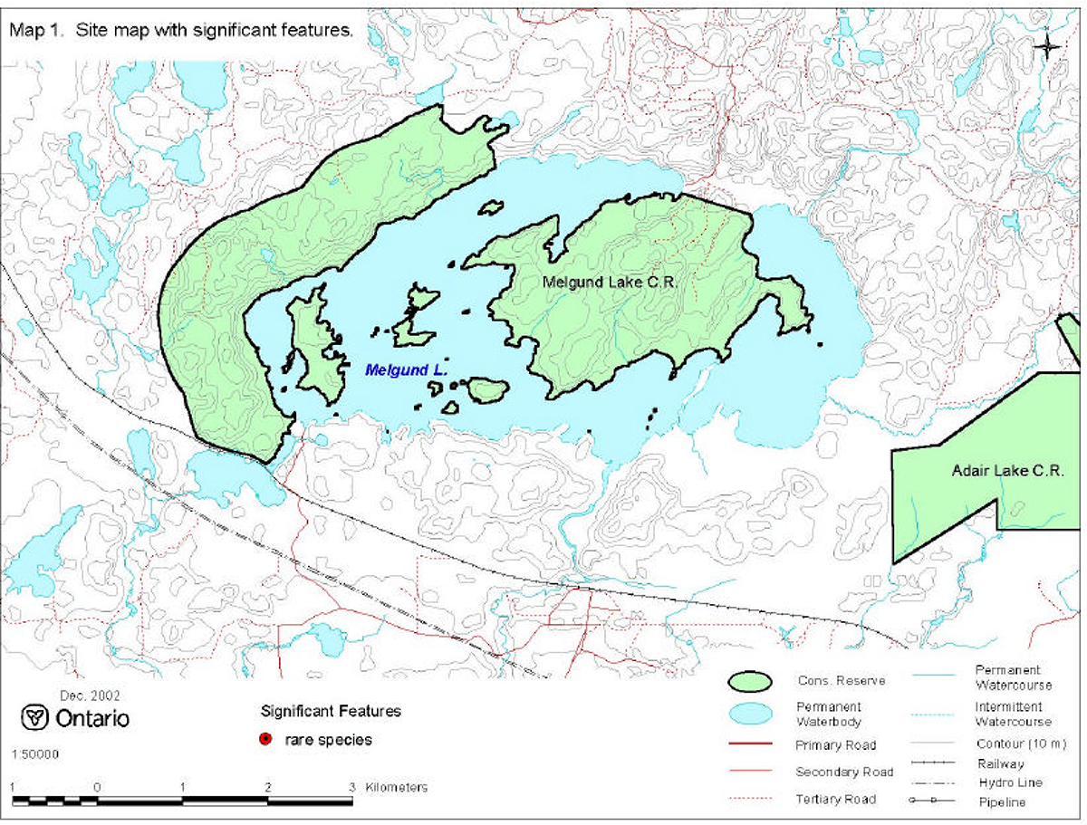
Map 1: Site map with significant features

Enlarge map 1: Site map with significant features
Photo 1. Red and white pine stand on Melgund Lake (photo by Alicia Morin).
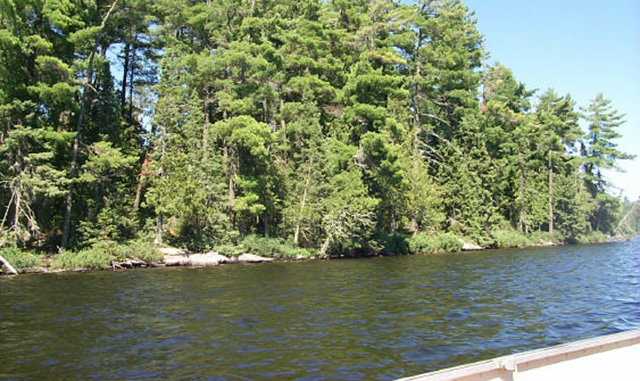
Photo 2. Trembling aspen and black spruce mixedwoods make up most of the forest.
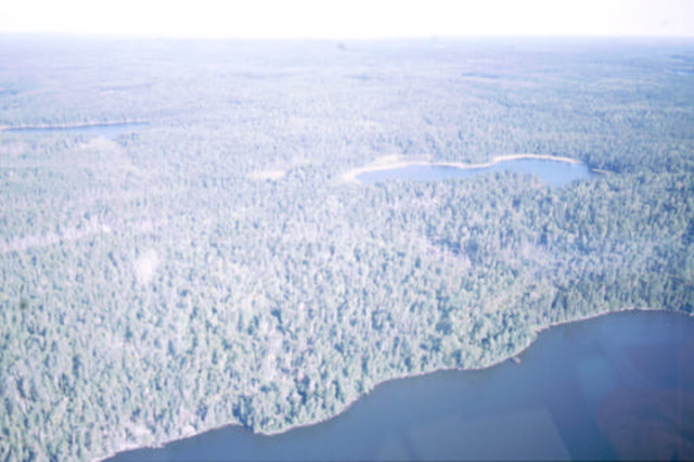
Photo 3. Black spruce stand with feathermoss on silty soil.
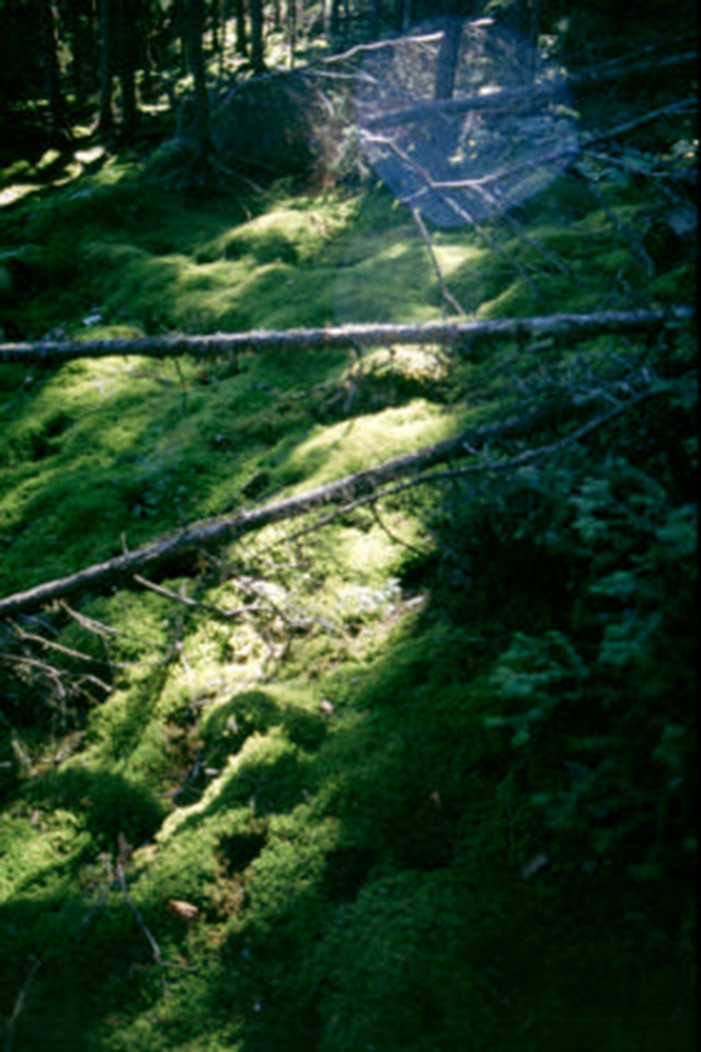
Photo 4. The Conservation Reserve includes 37 islands in Melgund Lake.
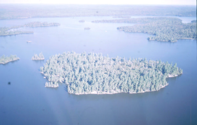
Photo 5. Moose are common in the Conservation Reserve (photo by Alicia Morin).
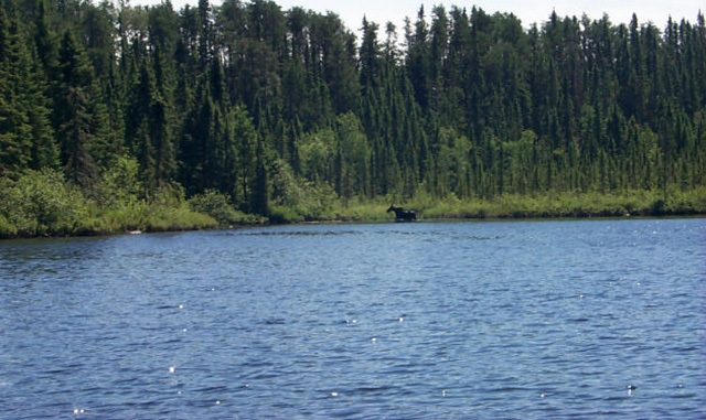
Table 2. Rapid assessment plot summary from Melgund Lake.
| Plot No. | V / W Type | ES Type | Date |
|---|---|---|---|
| 1 | W15 | ES45 | September 16 2002 |
| 2 | V29 | ES12 | September 16 2002 |
| 3 | W3 | ES49 | September 16 2002 |
| 4 | V12 | ES24 | September 16 2002 |
| 5 | V4 | ES28 | September 16 2002 |
| 6 | V10 | ES28 | September 16 2002 |
Table 3. Landform-vegetation (LV) type representation for Melgund Lake Conservation Reserve in Ecodistrict 4S-3 (analysis by Ontario Parks; Steve Kingston pers. comm.).*
| LV - Description | Ecodistrict 4S3: Area (ha) | Ecodistrict 4S3: Representation target % | Ecodistrict 4S3: Representation Target ha | Ecodistrict 4S3: Protected Areas (ha) | Melgund Lake: Area (ha) | Melgund Lake: Contribution to Ecodistrict Target (%) | Melgund Lake: Contribution to Existing Protection (%) | Melgund Lake: Confirmed in Field ** |
|---|---|---|---|---|---|---|---|---|
| Bedrock-Dense Coniferous Forest | 82,481 | 12 | 9,898 | 1,439 | 291 | 3 | 20 | X |
| Bedrock-Mixed Forest – mainly Coniferous | 49,571 | 12 | 5,949 | 1,794 | 211 | 4 | 12 | X |
| Bedrock-Sparse Coniferous Forest | 35,825 | 12 | 4,299 | 542 | 63 | 1 | 12 | X |
| Bedrock-Dense Deciduous Forest | 31,139 | 12 | 3,737 | 989 | 463 | 12 | 47 | X |
| Bedrock-Mixed Forest – mainly Deciduous | 17,953 | 12 | 2,154 | 250 | 41 | 2 | 16 | X |
| Glaciolacustrine deposits-Dense Deciduous Forest | 17,256 | 12 | 2,071 | 254 | 12 | 1 | 5 | X |
| Glaciolacustrine deposits-Sparse Coniferous Forest | 12,134 | 12 | 1,456 | 272 | 1 | <1 | <1 | X |
*The LV matrix was recently refined by Ontario Parks in several ways:
- revised Ecodistrict boundaries
- increased resolution of Landcover28 data (25 m vs. 100 m)
- terrain is no longer used as a modifier
- more accurate surficial geology data
- updated approach to representation targets
**"X" observed in field; "-" not observed in field
Table 4. Original version of landform-vegetation (LV) type representation for Melgund Lake Conservation Reserve used in Ontario Living Legacy gap analysis.
| Site District | Landform | Surface expression | burn | conifer | conifer mixed | deciduous | deciduous mixed | sparse forest | Grand Total |
|---|---|---|---|---|---|---|---|---|---|
| 4S-4 | Ground Moraine | Moderately Broken Weakly Broken |
25 114 | 236 | 68 308 | 66 181 |
13 4 |
114 |
172 957 |
| 4S-4 | Ground Moraine total | 139 | 236 | 376 | 247 | 17 | 114 | 1,129 | |
| 4S-4 | Lacustrine deposit | 4 | 4 | ||||||
| Grand Total | 143 | 236 | 376 | 247 | 17 | 114 | 1,133 |
Table 5. Site type matrix for Melgund Lake Conservation Reserve.
| Arid | Very Dry | Dry | Dry Mesic | Mesic | Wet Mesic | Wet | Very Wet | Saturated | Open Water | |
|---|---|---|---|---|---|---|---|---|---|---|
| Colder: Rock | ES7 | ES12 | ES12 | |||||||
| Colder: Sand | ES19 - ES22 | ES19 - ES22 | ||||||||
| Colder: Loam | ES26 ES28 | ES31 | ||||||||
| Colder: Clay | ||||||||||
| Colder: Organic | ES34 - ES36 ES39 |
ES34 - ES36 ES39 |
||||||||
| Normal: Rock | ES12 | ES12 | ||||||||
| Normal: Sand | ES19 - ES22 | ES19 - ES22 | ||||||||
| Normal: Loam | ES26 ES28 | ES31 | ES44 | |||||||
| Normal: Clay | ||||||||||
| Normal: Organic | ES37 | ES44 ES45 | ES49 | |||||||
| Warmer: Rock | ES7 | |||||||||
| Warmer: Sand | ES17 ES18 | |||||||||
| Warmer: Loam | ES24 | ES38 | ||||||||
| Warmer: Clay | ||||||||||
| Warmer: Organic |
Melgund Lake species lists
Plant list
The following plants were observed in Melgund Lake Conservation Reserve in 2002. Taxonomic order and species names generally follow Morton and Venn (1990). Introduced species are marked "I". Voucher specimens were collected for species marked "*".
| Family dryopteridaceae | True Fern Family |
|---|---|
| Woodsia ilvensis (L.) R.Br. | Rusty Woodsia |
| Family polypodiaceae | Polypody Family |
|---|---|
| Polypodium virginianum L. | Rock Polypody |
| Family Lycopodiaceae | Clubmoss Family |
|---|---|
| Lycopodium annotinum L. | Bristly Clubmoss |
| Lycopodium clavatum L. | Common Clubmoss |
| Lycopodium complanatum L. | Ground Cedar |
| Lycopodium obscurum L. | Flat-branched Tree Clubmoss |
| Family Cupressaceae | Juniper Family |
|---|---|
| Thuja occidentalis L. | Eastern White Cedar |
| Family Pinaceae | Pine Family |
|---|---|
| Abies balsamea (L.) Miller | Balsam Fir |
| Picea glauca (Moench) Voss | White Spruce |
| Picea mariana (Miller) BSP | Black Spruce |
| Pinus banksiana Lambert | Jack Pine |
| Pinus strobus L. | White Pine |
| Family Alismataceae | Water Plantain Family |
|---|---|
| Sagittaria latifolia Willd. | Broad-leaf Arrowhead |
| Family Araceae | Arum Family |
|---|---|
| Acorus americanus L. | Sweet Flag |
| Calla palustris L. | Water Calla |
| Family Cyperaceae | Sedge Family |
|---|---|
| Carex aquatilis Wahlenb . | Water Sedge |
| Carex lasiocarpa Ehrh. | Wire Sedge |
| Dulichium arundinaceum (L.) Britton | Three-way Sedge |
| Family Hydrocharitaceae | Frog’s-bit Family |
|---|---|
| Elodea canadensis Rich. ex. Michaux | Canada Waterweed |
| Family Iridaceae | Iris Family |
|---|---|
| Iris versicolor L. | Wild Iris |
| Family Juncaceae | Rush Family |
|---|---|
| * Juncus brevicaudatus (Engelm.) Fern. | Short-tailed Rush |
| Family Lemnaceae | Duckweed Family |
|---|---|
| Lemna minor L. | Lesser Duckweed |
| Spirodela polyrhiza (L.) Schleiden | Greater Duckweed |
| Family Liliaceae | Lily Family |
|---|---|
| Clintonia borealis (Aiton) Raf. | Blue Bead Lily |
| Maianthemum canadense Desf. | Wild Lily-of-the-valley |
| Family Orchidaceae | Orchid Family |
|---|---|
| Cypripedium acaule Aiton | Stemless Ladyslipper |
| Goodyera tesselata Lodd. | Checkered Rattlesnake Plantain |
| Family Poaceae | Grass Family |
|---|---|
| Agrostis scabra Willd. | Ticklegrass |
| Calamagrostis canadensis (Michaux ) P.Beauv. | Bluejoint Grass |
| Danthonia spicata (L.) P.Beauv. ex Roemer & Schultes | Poverty Grass |
| Elymus trachycaulus (Link) Gould in Shinn. | Slender Wheat Grass |
| Glyceria borealis (Nash) Batch. | Northern Manna Grass |
| Oryzopsis asperifolia Michaux | Rough-leaved Mountain Rice |
| Phalaris arundinacea L. | Reed Canary Grass |
| Poa palustris L. | Fowl Blue Grass |
| Schizachne purpurascens (Torrey) Swallen | Purple Melic Grass |
| Family Potamogetonaceae | Pondweed Family |
|---|---|
| Potamogeton amplifolius Tuckerman | Large-leaf Pondweed |
| Potamogeton natans L. | Floating-leaved Pondweed |
| Potamogeton richardsonii (A. Bennett) Rydb . | Richardson’s Pondweed |
| Potamogeton spirillus Tuckerman | Snail’s-seed Pondweed |
| Potamogeton zosteriformis Fern. | Flat-stemmed Pondweed |
| Family Sparganiaceae | Bur-reed Family |
|---|---|
| Sparganium emersum Rehmann | Common Bur-reed |
| Sparganium natans L. | Least Bur-reed |
| Family Typhaceae | Cattail Family |
|---|---|
| Typha latifolia L. | Common Cattail |
| Family Aceraceae | Maple Family |
|---|---|
| Acer spicatum Lam. | Mountain Maple |
| Family Apiaceae | Parsley Family |
|---|---|
| Sium suave Walter | Water Parsnip |
| Family Araliaceae | Ginseng Family |
|---|---|
| Aralia hispida Vent. | Bristly Sarsaparilla |
| Aralia nudicaulis L. | Wild Sarsaparilla |
| Family Asteraceae | Sunflower Family |
|---|---|
| Aster ciliolatus Lindley | Ciliate Wood Aster |
| Aster lanceolatus Willd. | Panicled Western Aster |
| Aster macrophyllus L. | Large-leaved Aster |
| Bidens frondosa L. | Bur Marigold |
| Euthamia graminifolia (L.) Nutt. | Grass-leaved Goldenrod |
| Megalodonta beckii (Torrey ex Spreng) E. Greene | Water Marigold |
| Solidago nemoralis Aiton | Wood Goldenrod |
| Family Betulaceae | Birch Family |
|---|---|
| Alnus incana (L.) Moench | Speckled Alder |
| Alnus viridis (Chaix) DC. | Green Alder |
| Betula papyrifera Marshall | White Birch |
| Family Caprifoliaceae | Honeysuckle Family |
|---|---|
| Diervilla lonicera Miller | Bush Honeysuckle |
| Linnaea borealis L. | Twinflower |
| Family Cornaceae | Dogwood Family |
|---|---|
| Cornus canadensis L. | Bunchberry |
| Family Ericaceae | Heath Family |
|---|---|
| Chamaedaphne calyculata (L.) Moench | Leatherleaf |
| Gaultheria hispidula (L.) Muhlenb . ex Bigelow | Creeping Snowberry |
| Vaccinium angustifolium Aiton | Low Blueberry |
| Family Fumariaceae | Fumitory Family |
|---|---|
| Corydalis sempervirens (L.) Pers. | Pale Corydalis |
| Family Guttiferae | St. John’s-wort |
|---|---|
| * Hypericum majus (A.Gray) Britton | Larger St. Johnswort |
| Triadenum fraseri (Spach) Gleason | Marsh St. Johnswort |
| Family Haloragaceae | Water Milfoil Family |
|---|---|
| Myriophyllum sibiricum Komarov | Northern Water Milfoil |
| Family Lamiaceae | Mint Family |
|---|---|
| Lycopus uniflorus Michaux | Northern Bugleweed |
| Scutellaria galericulata L. | Common Skullcap |
| Family Lentibulariaceae | Bladderwort Family |
|---|---|
| Utricularia intermedia Hayne | Flat-leaved Bladderwort |
| Family Myricaceae | Bayberry Family |
|---|---|
| Myrica gale L. | Sweet Gale |
| Family Onagraceae | Evening-primrose |
|---|---|
| Epilobium angustifolium L. | Fireweed |
| Family Polygonaceae | Buckwheat Family |
|---|---|
| Polygonum cilinode Michaux | Fringed Bindweed |
| Family Primulaceae | Primrose Family |
|---|---|
| Lysimachia terrestris (L.) BSP | Swamp Loosestrife |
| Family Pyrolaceae | Wintergreen Family |
|---|---|
| Chimaphila umbellata (L.) Barton | Pipsissewa |
| Family Ranunculaceae | Buttercup Family |
|---|---|
| Ranunculus longirostris Godron | Curly White Water Crowfoot |
| Family Rosaceae | Rose Family |
|---|---|
| Fragaria virginiana Miller | Wild Strawberry |
| Potentilla norvegica L. | Rough Cinquefoil |
| Potentilla palustris (L.) Scop. | Marsh Cinquefoil |
| Prunus pensylvanica L.f. | Pincherry |
| Rubus idaeus L. | Common Raspberry |
| Sorbus decora (Sarg.) C.Schneider | Showy Mountain Ash |
| Spiraea alba Duroi | Narrow-leaved Meadow Sweet |
| Family Salicaceae | Willow Family |
|---|---|
| Salix humilis Marshall | Upland Willow |
Melgund Lake animal species list
The following animals were observed in Melgund Lake Conservation Reserve in 2002. Taxonomic order and nomenclature follow AOU (1998) for birds and Banfield (1974) for mammals. Fish species were reported from lakes in Melgund Lake Conservation Reserve in OMNR lake surveys.
Birds
| Loons | Family Gaviidae |
|---|---|
| Common Loon | Gavia immer |
| Cranes | Family Gruidae |
|---|---|
| Sandhill Crane | Grus canadensis |
| Woodpeckers | Family Picidae |
|---|---|
| Black-backed Woodpecker | Picoides arcticus |
| Northern Flicker | Colaptes auratus |
| Pileated Woodpecker | Dryocopus pileatus |
| Jays, Crows and Ravens | Family Corvidae |
|---|---|
| Gray Jay | Perisoreus canadensis |
| Common Raven | Corvus corax |
| Wood-warblers | Family Parulidae |
|---|---|
| Yellow-rumped Warbler | Dendroica coronata |
Fish
| Salmon Family | Family Salmonidae |
|---|---|
| Lake Whitefish | Coregonus clupeaformis |
| Pike Family | Family Esocidae |
|---|---|
| Northern Pike | Esox lucius |
| Minnow Family | Family Cyprinidae |
|---|---|
| Spottail Shiner | Notropis hudsonius |
| Sucker Family | Family Catostomidae |
|---|---|
| White Sucker | Catostomus commersoni |
| Perch Family | Family Percidae |
|---|---|
| Yellow Perch | Perca flavescens |
| Sauger | Stizostedion canadense |
| Walleye | Stizostedion vitreum |
Mammals
| Squirrels | Family Sciuridae |
|---|---|
| Red Squirrel | Tamiasciurus hudsonicus |
| Weasels and Their Allies | Family Mustelidae |
|---|---|
| Ermine | Mustela erminea |
| Deer | Family Cervidae |
|---|---|
| Moose | Alces alces |
Appendix E: Recreation Inventory Checksheet
Recreation Inventory Checklist
| Name: | Melgund lake |
|---|---|
| Map name: | Dyment |
| NTS Number: | 52 F/9 |
| UTM reference: | 15548678549951 |
| OBM Number: | 15550054900, 15540055000 |
| Latitude: | 49° 38' |
| Longitude: | 92° 19' |
| Area (ha): | 1,215.00 |
| Ownership: | Crown |
| MNR region: | Northwest |
| MNR district: | Dryden |
| Park zone: | Northwest |
| County: | N/A |
| Township: | Avery, unsurveyed |
| Recreation features | Recreation activities |
|---|---|
|
|
| Recreation factors | Features | Rating: Very High, High, Moderate, Low, N/A |
|---|---|---|
| Most Scarce Feature: | N/A | |
| Feature Scarcity: | N/A | |
| Most Unique Feature: | N/A | |
| Activity Attraction Capability: | High | |
| Scenic Attractiveness: | Moderate | |
| Geographic Significance: | Low | |
| Feature Significance: | Moderate | |
| Most Sensitive Feature To Recreation Use: | 4 | |
| Feature Sensitivity To Recreation Use: | Low | |
| Most Sensitive Feature To Resource Development: | 6 | |
| Feature Sensitivity To Resource Development: | Low | |
| Cultural/Historic and Archaelogical Features: | C |
Comments: Discussions with a Camper coming out of the camp site at the North end indicated that the camp site is still used quite a bit even though access is difficult - July 18, 2002
Date Compiled: Wednesday, July 31, 2002
Compiler: Alicia Morin, Brendan Greenslade, Ashleigh Prior
Source: Recreation Resource Inventory Stadndards and Proceedures Draft Report, Gov. of British Columbia, Ministry of Forests Range, Recreation and Forests Practices Branch, March 1995.
Ministry of Natural Resources
Ministère des Richesses naturelles
Ontario Ministry of Natural Resources, Ontario Parks
300 Water Street, Peterborough, Ontario K9J 8N1
Appendix F: Permitted Uses Table
Summary of Generic Permitted Uses in Conservation Reserves within the planning area
| Use | Existing Conservation Reserves | New Conservation Reserves in the Planning Area |
|---|---|---|
| Commercial timber harvest, commercial hydro development | Not permitted. | Not permitted. |
| Mineral exploration and mining | Not permitted. | There will be no new exploration permitted. |
| Bait fishing, commercial fishing, commercial fur harvesting, wild rice harvesting | Existing use permitted to continue, unless there are significant demonstrated conflicts. New operations can be considered, subject to the "test of compatibility". | Existing use permitted to continue unless there are significant demonstrated conflicts. New operations can be considered, subject to the "test of compatibility". |
| Sport hunting | Permitted. | Permitted. |
| Sport fishing | Permitted, except in specific fish sanctuaries. | Permitted, except in specific fish sanctuaries. |
| Seasonal recreation camps ("hunt camps") | Existing camps permitted to continue, and may be eligible for enhanced tenure, but not purchase of land (see 6.1.8). | Existing authorized camps permitted to continue, and may be eligible for enhanced tenure but not purchase of land (see 6.1.8). |
| Commercial Bear Hunting | Existing use permitted to continue. New operations not permitted. | Existing use permitted to continue. New operations not permitted. |
| Tourism facilities (for resource-based tourism) and recreational trails | Existing authorized facilities and trails can continue, unless there are significant demonstrated conflicts. No new tourism facilities permitted. New trails can be considered as part of planning for an individual reserve. | Existing authorized facilities and trails (motorized and non-motorized) can continue, unless there are significant demonstrated conflicts. Tourism facilities can apply to upgrade tenure from LUP to lease. New tourism and trail facilities can be considered as part of planning for an individual reserve. |
| Land Disposition | Sale of lands is not permitted. Renewals of existing leases or land use permits are permitted; requests for transfer of tenure will be considered in the context of the Statement of Conservation Interest or Resource Management Plan. New leases or land use permits permitted for approved activities. | Sale of lands is not permitted. Renewals of existing leases or land use permits are permitted; requests for transfer of tenure will be considered in the context of the Statement of Conservation Interest or Resource Management Plan. New leases or land use permits permitted for approved activities. |
| Roads | Existing roads can continue to be used, but new roads for resource extraction will not be permitted. | Existing roads can continue to be used, but new roads for resource extraction will not be permitted, with the exception of necessary access for mineral exploration and development. |