Misery Bay Provincial Park Management Plan
This document provides policy direction for the protection, development and management of Misery Bay Provincial Park and its resources.
Approval statement
I am pleased to approve the Misery Bay Provincial Nature Reserve Management Plan. Misery Bay was regulated in 1989 for protection under Ontario’s Provincial Parks Act.
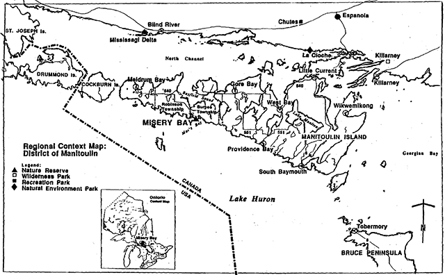
Misery Bay is located on Manitoulin Island’s south shore, 35 kilometres west of the Town of Gore Bay in Burpee Township. As a park, nature reserve class, it will be managed for the protection of representative natural features while affording opportunities for the appreciation of its natural heritage today and for future generations.
This nature reserve contains dolostone pavements and barrens, alvars and wetlands and upland forests. Some provincially rare plants occur here too. This area’s ecological communities, plants and animals and geological landforms are within the Manitoulin site district of Ontario.
The park’s provincially significant natural heritage values will be protected through management policies in the plan. Policies for day use facilities include the development and operation of trails and viewing areas.
I am confident that the values and uses identified in this plan can be sustained with Parks Ontario working in cooperation with Burpee Township, the Friends of Misery Bay, and the Manitoulin Nature Club.
Norm Richards
Managing Director
Parks Ontario
1. Introduction
Misery Bay Provincial Nature Reserve is located on Manitoulin Island, 35 kilometre west of Gore Bay in Burpee Township (Figure 1).
Misery Bay joined other provincial nature reserves in May 1989, representing provincially important ecological communities.
Misery Bay was first identified as an important naiural area in a survey of Manitoulin Island undertaken by the Federation of Ontario Naturalists in 1974.
The Nature Conservancy of Canada (N.C.C.), a private non-profit organization, purchased lands for the establishment of Misery Bay Provincial Nature Reserve. The core of what is now park (542 ha/1339 acres) was purchased in 1978 from Calvin and Eunice Sifferd. A second parcel (162 ha/400 acres) was acquired by similar means in 1979 (Robertson property). A portion of additional acquisitions brought 156 hectares into the area. The N.C.C. then sold these parcels of land at half the market value to the Ontario Government for the Ministry of Natural Resources (M.N.R.) in 1979 to create a nature reserve. The Ontario Heritage Foundation (O.H.F.) holds a conservation easement, which was the first of its kind in Ontario in 1984, with the Quebec and Ontario Paper Company (Q.U.N.O.) for 120 hectares (300 acres) of land bordering the park. Parks Ontario with the co-operation of Burpee Township and local and provincial interests, will pursue agreements to manage Misery Bay (see Operations Policies, 9.1 Co-operating Association, Page 9).
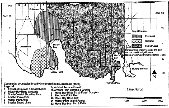
A biological inventory (MacDonald 1980) of Misery Bay describes representative ecological communities including two that are rare to the province (Figure 2). The dolostone plains and bay head wetlands are representative and significant communities, given their underlying landforms, plant diversity and extent. Rare plants are found within the park.
The variety of local landforms and moderating climatic effects of Lake Huron as well as transitional conditions between the northern and southern climates produce a diverse and sensitive setting.
Interest in viewing and studying the natural features of Misery Bay has been shown by scientists, local residents and travellers, both from within and outside Ontario.
2. Summary of management planning and significant issues
Management planning for Misery Bay was initiated in September of 1994 with the support of the Manitoulin Island Ecotourism Committee and Burpee Township. With their involvement and creative support persons were hired and worked in co-operation with Parks Ontario staff to update earlier planning documents. A Background Information report and Preliminary Management Plan were prepared. The latter was mailed out to adjacent landowners and local and provincial interests in 1995. All planning material was reviewed with people who attended a meeting at the Burpee Township hall.
A number of issues were reviewed with the public through the above process. These can be summarized as: the size and boundaries of the park; proposed zoning; proposed facilities to support a trail system including barrier free (wheelchair) access; and the need for ongoing involvement of interested individuals in park management and operations through a cooperative association, the Friends of Misery Bay. The plan’s policies address all of these issues.
3. Classification
Misery Bay is classified as a Provincial Nature Reserve. It represents distinct natural habitats and landforms of the province for their intrinsic value. Management of the area will provide opportunities for research to benefit present and future generations of residents and visitors to Ontario. There will be secondary benefits for recreation and tourism once the park is operational.
4. Goal
To protect ecological communities and landforms in Misery Bay Provincial Nature Reserve and to offer nature appreciation, educatlon and scientific benefit for the people of Ontario.
The above goal and the following objectives for the nature reserve have been derived from the Ontario Provincial Parks Planning and Management Policies (OMNR 1992).
5. Objectives
A Provincial nature reserve in the Provincial Park System protects representative ecosystems by conserving. natural features and sustaining their ecological functions. A second objective enables management to offer opportunities for residents' and visitors' appreciation of the intrinsic value of environments along Manitoulin Island’s south shore.
5.1 Protection
To protect representative geological and biological features associated with Manitoulin Island’s south shore dolostone terrain.
Glacial polished dolostone, relict beach and rounded boulder deposits are evidence of the recession of glacial Lake Nipissing some 10,000 years ago at Misery Bay. Post glacial weathering and soil development and today’s moderate climate in the Great Lakes basin create a diverse environment. Ecological communities support plants and animals on bedrock pavement, wetlands, savannahs and a minor escarpment in the park. Over 470 species of plants are known to occur here. The influence of the moderate climate and the terrain allows some rare plants to exist here. These natural features within the park contribute to represent some of the biological diversity of the northern Great Lakes Forest, Site Region SE, Manitoulin Site District.
5.2 Heritage appreciation
To provide opportunities for exploration and appreciation of the natural heritage of this portion of Manitoulin Island.
A natural heritage education plan will identify information and interpretation approaches for park landscapes and plants and animals of Manitoulin’s south shore. A trail system will enable visitors to see the bay’s wetlands, Lake Huron shoreline, interior dolostone plains and forests. Two elevated observation platforms will provide opportunities to view some habitats that are otherwise unseen or unnoticed. Visitors will also be able to witness seasonal occurrences of wildlife including interior, shore and migrating birds. Park features will be interpreted by literature and trail-side displays at rest areas noting significant natural features and points of interest.
6. Park boundary and adjacent lands
Figure 3 shows Misery Bay Provincial Nature Reserve and adjoining lands. The nature reserve boundaries will be surveyed and marked.
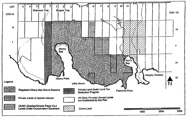
Some adjoining private lands (72 ha) not within the regulated boundaries will be acquired as funds permit, and as owners are willing to sell:
- Frechette Point: 22 ha
- Lot 6, Con. III: 20 ha
- Lot 9, Con. IV, Part 2: 10 ha
- Lot 9, Con. IV, Part 3: 10 ha
- Lot 9, Con. IV, Part 4: 10 ha
Lands purchased for the Crown to the east of the park and north of Mac’s Bay will provide a buffer to complement the conservation of core. park values and ecological functions. Future studies of the park and bordering lands will monitor the long term integrity of representative features and may identify other steps to protect park values.
7. Zoning
A nature reserve zone and two access zones will guide park management (Figure 4).
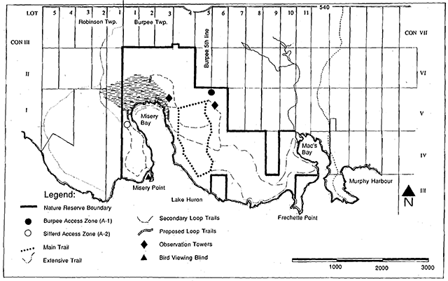
7.1 Sifferd nature reserve zone
Policies for this zone (758 ha) will protect the representative features of the park. Long term research into plant communities to understand processes that sustain them will assist management. The park will contribute to representation for the Manitoulin Site District.
Dolostone bedrock in the park was polished by glaciers 10,000 years ago. They appear as flat pavement scattered with rounded boulders. Bedrock surfaces are marked by glacial scratches or striae and are crisscrossed by regular weathering cracks or joint lines of varying depths. After glacial ice melted higher lake levels creating minor sand bars on the bedrock.
When the waters receded plants migrated into suitable habitats until the modern communities were formed. Today, the Lake Huron shoreline is 15 kilometres long in. the park. A series of small streams flow out of the park draining delta, fen, marsh, swamp and bog wetlands. Dolostone plain alvars or dry sites with scattered plants, Jack Pine savannahs, upland mixed forests on shallow sandy soils and a minor escarpment up to 3 metres high occur in the interior lands.
Park development in this zone will be limited. Trail related facilities will encourage low intensity use: signs, a bird viewing blind and interpretive sites. Trails for the most part will follow old roads and paths. Wetland viewing will be possible from short boardwalk sections and an elevated platform.
Some 470 plant species have been recorded in the nature reserve. These include prairie and southern plants that are drought tolerant. Manitoulin Gold (Hymenoxys acaulis), a provincially rare plant, is abundant in otherwise bare bedrock pavements. Gnarled Jack Pine dominates the driest treed sites. Within short distances there are water loving sundews, rushes and orchids. Cedar is common with Trembling Aspen on wetter sites. Relict glacial beach ridges support a mixed forest including Jack, White and Red Pine, Sugar Maple and American Beech with Eastern Hemlock. An ever changing display of wildflowers with a variety of colours appear in the growing season.
7.2 Access zones
Two access zones provide staging areas for the nature reserve (Figure 4).
A-1 Burpee access (1 ha)
The Burpee Access will be the primary public entry south of Highway 540. This zone will access the centre of the park. The Burpee Township 5th line is outside the park while parking and the start of interpretive trails are in the park.
The portion of the zone linking parking to the Burpee Township 5th line will include a short section of road. This will be from the park’s north boundary south a few hundred metres to the parking lot. The corridor is 25 metres wide centred on the mid line of the road. This definition includes road alignment. Aggregate required for the road and parking surfaces will be obtained outside the park.
The zone is comprised of a parking area for 15 vehicles, designed with future expansion capabilities, a composting washroom facility and a small trailhead orientation building for operation and interpretative purposes. The needs of barrier free access in this zone will be assessed. An observation tower will provide a scenic vantage point to orient visitors to the park’s natural heritage features and surrounding lands.
A dedication plaque for Mr. Calvin and Mrs. Eunice Sifferd, the previous landowners of the core area of Misery Bay, will acknowledge their vision for natural heritage protection and their support for the nature reserve.
A-2 Sifferd access
(1 ha via Robinson Township)
The Sifferd Access contains the property and cottage in private ownership until 1998. Under the terms of an agreement to acquire the Sifferd lands, this property will become part of the nature reserve in the future. These lands and the. improvements will be assessed to determine their best use.
This access zone could serve visitors entering via the Little Lake Huron Road to view the most extensive dolostone pavement in the park. It could provide access to the Sifferd cottage once it reverts to park management. This access will be very specialized. The cottage could serve several important functions: research station and meeting/ education/storage area for the cooperating association (see section 9.1 ), resource library, interpretation and display area.
8. Heritage protection
The 1983 Espanola District Land Use Guidelines identified Misery Bay as a nature reserve class provincial park. It outlined broad resource managementpolicies. This management plan provides additional detail required for protection (e.g. vegetation and wildlife). These policies will aid in the preparation of implementation plans including an operation plan and agreements for park management and operation.These policies do not apply to private land adjoining the park.
Although the policies are presented in separate categories, all planning and management will recognize that the components are interrelated. An integrated approach will be required in order for the park goal and objectives to be achieved.
8.1 Land and water
Commercial mineral and aggregate exploration and/or extraction is not permitted. Land disposition for private use will not be permitted. Wherever possible, tenure documents for patents adjacent to the park sho.uld stipulate conditions to ensure that property or rights of way under easement, lease or license of oceupation are managed in a manner least disruptive to the park’s natural values. For example unauthorized trails into the park from private land will be discontinued.
Management of lands and waters outside access zones will be directed to sustain natural communities. In the interest of visitor education and safety, interpretive facilities will direct use to select natural feature locations. This will follow a series of well marked trails to viewing and rest points (see 10.3 Interpretive Trails).
8.2 Vegetation
A vegetation management plan will identify research and management policies to sustain plant communities.
Commercial forest oper tions are not permitted. Vegetation will only be removed for the development of the two access zones and in the nature reserve zone where interpretive infrastructure is located according to approved site plans. Non-native plant species will not deliberately be introduced. Some non-native plants are known to occur in the park (e.g. Sedum acre). These will be studied to determine the status of their populations and whether they are affecting the health of native plant populations and communities. Measures may be taken to remove evasive plant populations.
Natural fire is recognized as an integral process for evolving plant communities and will normally be allowed to burn, unless it threatens human life, access zone values, lands outside the park, or the values that the nature reserve was established to protect. Fire management needs will be identified in the vegetation management plan. Where fire suppression is advocated it will follow low impact techniques such as water bombing. The use of trucks and heavy equipment will be avoided where possible. The park operating plan will identify safety policies around fire management.
Native insects and diseases are recognized as an integral component of the park’s ecology and will be allowed to progress naturally. Where native or non-native insects or diseases threaten park values or adjacent areas, they will be controlled by biological methods whenever possible.
8.3 Wildlife
Wildlife protection within the nature reserve will be directed to the maintenance of an evolving natural succession. Non-native species will not deliberately be introduced and missing native species may be reintroduced if it is desirable to sustain park values.
Animal populations may be controlled when essential for human health and safety. Control techniques will be used that have negligible effects on the park’s natural heritage values.
Only commercial trapping by Status Indians under Treaty rights is allowed. Hunting is not permitted. Sport fishing is limited in the park as there is no extensive sport fish habitat. Sport fishing regulations that prevail on Manitoulin will apply.
9. Park operations
Operations policies apply only to park land and will be organized through an operating plan.
Public motorized vehicles of any kind are not allowed except for cars and trucks in access zones. Vehicles required for park management and emergency situations will be permitted in the nature reserve zone under the superintendent’s authority.
Park development and operation will include: access infrastructure, interpretive materials, walking trails, limited boardwalk, an elevated viewing platform, a bird viewing blind, and an observation tower. Where feasible, agreements may be made with others to assist in plan implementation for park development and operation.
Approaches to user fee collection will be evaluated with an interest in collecting fees.
9.1 Co-operating association
Parks Ontario will work with local communities and local and provincial interests to implement this plan. A co-operating association may emerge that could enter into an agreement to provide leadership and operational expertise to assist with the management of Misery Bay. This group could be known as the Friends of Misery Bay.
This association could explore and use alternate funding sources to Parks Ontario.
9.2 Natural heritage education
Nature reserves exist to protect natural heritage values. A natural heritage education plan will be prepared to direct information and interpretation policies for Misery Bay Provincial Nature Reserve. Various approaches will be identified in the natural heritage education plan including but not limited to: a fact sheet; map; feature guides; interpretive displays; trailside rest stops and signs in the access zones and along the trails or viewing locations in the nature reserve zone; and, seasonal staff.
Development and distribution of quality information about the park and area’s natural heritage values is a priority. Information that is provided will also convey the message that visitors have a responsibility to protect the area.
The interpretation of natural values in Misery Bay Provincial Nature Reserve will assist visitors to understand and appreciate the environment. Interpretation will focus on the significant representative ecological communities and geological landforms and processes.
Use of the nature reserve by educational groups or other special interests must be compatible with the protection needs of the park.
9.3 Research
A research plan will be prepared to encourage research in the provincial nature reserve. Persons are permitted to conduct research with the prior approval of Parks Ontario. Approval will be subject to parks guidelines and policies and applicable provincial and federal legislation.
There is an immediate and long term need for ongoing research and documentation of geology, plants and vegetation communities and associated animal populations in the nature reserve.
9.4 Recreation
Low-intensity day use activities are appropriate. These include non destructive nature study, scenic viewing, hiking, photography, art, snowshoeing and cross-country skiing.
10. Park development
Development of Misery Bay Provincial Nature Reserve will follow this management plan. Projects will be preceded by approved site plans. Notice will be provided prior to development subject to the Environmental Assessment Act. Development of Misery Bay will take many years through cooperative, innovative projects between provincial and local interests (Figure 4).
10.1 Day use access
Day use development in the Burpee access (A.1) will follow approved site plan(s).
An assessment will be undertaken of the Sifferd access (A.2) when the park acquires ownership of the Sifferd cottage lands. This will determine the most appropriate uses of the site.
10.2 Sign system
Signs along Highway 540 and within the park will be established following an approved sign plan. An entry sign will be posted once the park is operational.
10.3 Interpretive trails
Site and development plans will be prepared for the Misery Bay Nature Reserve trail system and associated facilities. The plans will provide final site details on interpretive loop trail lengths, limited boardwalk sections, a viewing platform, a bird viewing blind, and an observation tower.
An interpretive sign plan will be prepared for the trails. Existing roads and paths will be used wherever possible when aligning trails. Each access zone will link into the trail network.
An observation tower, situated on the Amabel terrace, may be constructed in the Burpee Access. The proposed tower would give a panoramic view of the Misery Bay area. Views from the tower would help to orient visitors to landmarks like the bay head wetland, Lake Huron shoreline and headlands. Traildevelopment will extend from the Burpee Access along the eastern side of Misery Bay to the south shore looping back along the Amabel terrace forest. Within this large loop there will be several smaller loops that will give visitors a view of different features of the nature reserve.
An extension of this loop will provide a choice for visitors to walk a longer, more demanding trail following the south shoreline to the Frechette dolostone plain alvar and Mac’s Bay. Travelling along the Mac’s Bay shoreline to the Mac’s Bay River then north along the River for a short distance where the trail will turn west crossing a glacial Lake Nipissing shore bluff then into the Amabel terrace forest area to return to the Burpee access point.
A trail will follow west from the main loop trail 'to the east and north shore of the bay head wetlands. A viewing platform would be located here adjacent to the different wetland communities. A few well located short boardwalk sections could allow visitors to view firsthand some of Manitoulin’s south shore fauna and wetland flora including several species of grasses, sedges and orchids. Interpretive trails emanating from the Sifferd access would be secondary trails in the overall trail plan for Misery Bay. The Sifferd trail system would otter more specialized interpretation of Jhe west side of Misery Bay’s landforms, geological formations and plants and animals. These would only be developed after the Sifferd lands become park property and an assessment is completed for their use.
The Sifferd Trail System will follow along the Fossil Hill dolostone plain alvar to the southern most point on this side of the bay. A bird viewing blind is proposed for a site in the vicinity of Misery Point. The latter would be constructed as a seasonal facility to be removed and stored off site during winter months due to possible damage with ice buildup on Manitoulin’s south shore. This facility may not be installed some years given fluctuating water levels on Lake Huron. It should be designed and sited such that its visibility is minimized from the Sifferd Trail. From this blind, visitors would observe bird movements at , this point on Lake Huron. As the trait follows the shoreline, it will travel west to a sward (wetland area) and then north along the west side of the Fossil Hill dolostone plain alvar across the Misery Point alvar and the inland forest back to the Sifferd access. The preliminary management plan suggested that it may be environmentally and economically feasible to link the Sifferd Trails to the Burpee Trail network. This will be studied.
11. Implementation priorities
This management plan will be reviewed at least once every 10 years following its approval or as the need arises.
The following are the priorities for implementing protection, development and operations. Actions from the plan are organized by phases to be implemented as funds permit and through the supporting efforts of the co-operating association.
Implementation: Phase 1
Completion of this phase will provide basic facilities for day use and a framework for managing trail use activities out of Burpee access.
Priorities
-
- survey and mark park boundary;
- assist in the formulation and implementation of the Friends of Misery Bay;
- develop an ongoing research plan;
- prepare and implement a natural heritage education plan;
- prepare an agreement(s) with interested groups to assist with park development and operation;
- prepare and implement site and development plans and operating plan for Burpee access zone:
- park entrance access road (inside the boundary on the Burpee 5th. line);
- parking lot;
- sign plan;
- observation tower;
- a small trail head orientation building;
- composting washroom facility;
- 15 kilometre self guided loop trail system including natural history brochure(s);
- assess user fee collection with provision to reinvest same back into the park; and,
- preparation and implementation of site and development plan for a dedication plaque for Mr. Calvin and Mrs. Eunice Sifferd.
Implementation: Phase 2
Completion of this phase will expand the trail system for additional hiking and cross-country skiing opportunities.
Priorities
-
- update the natural heritage education and sign plans;
- formulate and implement site and development plans and amend development and operation agreement(s) for additional hiking trail, wetland viewing platform and crosscountry ski trails; and,
- formulate and implement a vegetation management plan.
Implementation: Phase 3
Completion of this phase may provide for day use and research facilities from the Sifferd access.
Priorities
-
- work with the Sifferds' family (estate) to ease the transition of their remaining lands and assess the use of the cottage in the park;
- prepare and implement site and development plans and development and operation agreement(s) for the Sifferd Access as the area becomes part of the nature reserve;
- upgrade the natural heritage education plan to reflect changes to nature reserve policies;
- develop Sifferd Access and the bird viewing blind and study the link with Burpee access;
- develop and implement an ecosystem approach to adjacent land management to protect the park’s ecological integrity:
- landowner contact and ongoing study of park and adjacent land;
- long term resource protection through easements or purchase of significant lands as funds permit, and as owners are willing:
- Frechette Point: 22 ha
- Lot 6, Con. III: 20 ha
- Lot 9, Con. IV, Part 2: 10 ha
- Lot 9, Con. IV, Part 3: 10 ha
- Lot 9, Con. IV, Part 4: 10 ha
Select references
MacDonald, J. 1980. Misery Bay Provincial Nature Reserve Life Science features, for Ontario Ministry of Natural Resources,. 49 pp. and appendices.
Morton, J.K. and J.M. Venn. 1984. The Elora of Manitoulin Island. Second Revised Edition. University of Waterloo. Biological Series Number 28. 106 pp.
Ontario Ministry of Natural Resources, 1981. Provincial Nature Reserves in Ontario, Parks and Recreational Areas Branch.
Ontario Ministry of Natural Resources, 1983. Espanola District Land Use Guidelines.
Ontario Ministry of Natural Resources, 1984. Misery Bay Draft Policy and Concept Plan Alternatives.
Ontario Ministry of Natural Resources, 1984 (revised to 1994). Misery Bay Provincial Nature. Reserve Background Report. Park Management Planning Series.
Ontario Ministry of Natural Resources, 1992 Ontario Provincial Parks Planning and Management Policies, Parks and Recreational Areas Branch, Toronto.
Ontario Ministry of Natural Resources, 1994 Misery Bay Provincial Nature Reserve Preliminary Management Plan, Park Management Planning Series.
Ontario Ministry of Natural Resources, 1994 Ontario Provincial Park Management Planning Manual, Parks and Recreational Areas Branch, Toronto.