Missinaibi Provincial Park Management Plan
This document provides policy direction for the protection, development and management of Missinaibi Provincial Park and its resources.
Copies of this publication are available at the following locations:
Chapleau District Office
190 Cherry Street
Chapleau, ON P0M 1K0
Tel: 705-864-1710 ext. 214
Fax: 705-864-0681
Ontario Parks
Northeast Zone Office
199 Larch Street, Suite 404
Sudbury, ON P3E 5P9
Tel: 705-564-3170
Fax: 705-564-3171
This publication is also available on-line at: www.ontarioparks.com
© 2004 Queen’s Printer for Ontario
Printed in Ontario, Canada
Planning questions can be addressed to:
Ontario Parks
Northeast Zone Office
199 Larch Street, Suite 404
Sudbury, ON P3E 5P9
Tel: 705-564-3170
Superintendent, Missinaibi Provincial Park
Chapleau District Office
190 Cherry Street
Chapleau, ON P0M 1K0
Tel: 705-864-1710 ext. 214
Information related to Canadian Heritage River’s can be obtained at: www.chrs.ca
51259
(0.3 k, P.R. 04 03 31)
0-7778-8286-8
Cette publication est également disponible en français.
Approval statement
I am pleased to approve the Missinaibi Park Management Plan as the official policy for the protection and management of Missinaibi Provincial Park, including the OLL Additions (P1542, P1543, P1544). The plan reflects the Ministry of Natural Resources' and Ontario Parks' intent to protect the natural and cultural features of Missinaibi Provincial Park and maintain and develop high quality opportunities for outdoor recreation and heritage appreciation for the residents of Ontario and visitors to the Province.
The plan includes an implementation strategy and a summary of the public consultation that occurred as part of the planning process.
The plan for Missinaibi Provincial Park will be used to guide the management of the park. It may be reviewed to address changing issues or conditions.
Missinaibi River was nominated as a Canadian Heritage River for its unspoiled beauty, significant natural heritage features, and its importance to the history of Canada’s Aboriginal and fur trading route. This management plan will be submitted to the Canadian Heritage River’s Board as the final requirement for designating the Missinaibi River as a Canadian Heritage River.
I wish to extend my sincere thanks to all those who participated in this important process.
Yours truly,
Signed by:
Barton Feilders
A/Managing Director
Ontario Parks
Date: March 17, 2004
A vision for the future
Missinaibi Provincial Park
The Missinaibi Park Management Plan contains policies and direction that aim to achieve a consensus among the many and varied interests associated with the park and adjacent park related land uses.
A vision for the future, for Missinaibi Provincial Park is to provide:
- a protected, free flowing unimpeded waterway in northeastern Ontario linking the upland forests of the Precambrian Shield in the south to the spruce lowlands in the north. The Missinaibi River flows through a landscape that is also used for tourism and resource development. All activities will have the highest level of respect for the park; and
- a recreational waterway where canoeists, campers, anglers, motor boaters, hunters, and winter recreationists can enjoy the tranquility and peace the park has to offer. Park management will sustain a variety of recreational activities with policies to minimize use conflicts; and
- a nationally significant waterway eligible for designation as a Canadian Heritage River to recognize and monitor representative and important natural, cultural and recreational values, and to encourage an appreciation of the waterway protected in its natural state
This vision for the future establishes the context for policies in this park management plan.
Consideration of the Ministry of Natural Resource’s Statement of Environmental Values under the Environmental Bill of Rights
The Ministry of Natural Resources' Statement of Environmental Values (SEV) was prepared in accordance with the provisions of the Environmental Bill of Rights (EBR). It describes how the purposes of the EBR are to be considered whenever decisions are made which might significantly affect the environment.
The primary purpose of the EBR is "to protect, conserve and, where reasonable, restore the integrity of the environment". From the MNR's perspective, that broad statement of purpose translates into four objectives in its SEV:
- to ensure the long-term health of ecosystems by protecting and conserving our valuable soil, aquatic resources, forest and wildlife resources as well as their biological foundations
- to ensure the continuing availability of natural resources for the long-term benefit of the people of Ontario
- to protect natural heritage and biological features of provincial significance; and
- to protect human life, the resource base and property from forest fires, floods and erosion
The Ministry’s SEV has been considered throughout the preparation of this park management plan. The management plan for Missinaibi Provincial Park will further the objectives of managing Ontario’s resources on an ecologically sustainable basis.
1.0 Introduction
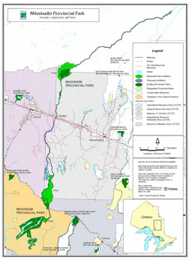
Missinaibi Provincial Park is one of the longest free flowing protected river corridors found in North America. The Missinaibi River is a major tributary in the Moose River watershed draining into James Bay. The park boundary includes the largest lakes in the headwaters of the Missinaibi River and is 501 kilometres in length and contains 87,293 hectares (Figure 1).
The park was originally established in 1970 (O. Reg. 165/70, appended by 695/70) and included only part of Missinaibi Lake. The Missinaibi River and Little Missinaibi Lake were designated as park reserve. In 1989 the park boundary was amended under Ontario Regulation 256/89 of the Provincial Parks Act and included Missinaibi, Little Missinaibi and Brunswick Lakes, and the Missinaibi and Brunswick Rivers. Management planning
Ontario’s Living Legacy (OLL) Land Use Strategy (1999) identified three park additions to Missinaibi Provincial Park: Missinaibi-Hay River (P1542), Missinaibi-East (P1543), and Missinaibi-Thunder House Falls (P1544) (Appendix IV). The boundaries of these OLL Additions were subject to public consultation prior to being regulated and added to the park. The OLL Additions were considered in the park management planning process. Boundary concerns related to the park’s views cape, significant resource values along the boundary, and the ecological integrity of the waterway were identified during earlier stages of the management planning process. Park additions that were reviewed by the Provincial Parks Council and approved by the Minister of Natural Resources during previous planning stages, were identified in the Missinaibi Preliminary Park Management Plan (revised), and are confirmed in this park management plan (Sections 6.0 & 7.0).
In addition to its provincial park status, the Missinaibi River is nominated as a Canadian Heritage River
Image of the Thunder House Falls, spring flow
Figure 1: Regional Setting
Little Missinaibi Lake and Missinaibi Lake are within the southern range of the boreal forest on the Canadian Shield. Here the hilly terrain and well- drained soils are dominated by jack pine. Tracks of white birch and poplar break the mosaic of fire origin pine forests.
Scattered, tall old white pine are regarded as superstory veterans, standing above, otherwise even-aged stands. As the Missinaibi River enters the Hudson Bay Lowlands the river passes into the northern range of the boreal forest. The Missinaibi River slows and widens in flat low-lying, poorly drained clay soils with levee features supporting white spruce, balsam fir, trembling aspen and white birch forests. Alder lined shores and islands with poplar and white spruce, occasionally include black ash and American elm. Treed wetland swamps along the Missinaibi River harbour tamarack and black spruce swamps. Signs of beaver and moose are everywhere along the waterway. Bald eagle and osprey may be seen travelling the waterways in search of prey.
2.0 Summary of significant issues
A number of significant issues have been identified through public consultation.
2.1 Adjacent forest management
(Sections 8.1.1, 9.3.3, 9.4.1, 9.4.3 & Appendix I)
Forest management plans set forest resource management direction for Crown lands bordering the park. A variety of strategies which protect park values and aesthetics, and which are based on sustainable forest management have been suggested by the public and interest groups. Viewscape management, timing and level of timber operations adjacent to the park, location and use of resource access roads and bridge crossings are considered in this park management plan.
2.2 Access
(Sections 7.5, 9.3 & Appendix I)
Access can lead to conflicts between different types of use, problems with erosion, litter and the possible deterioration of the park environment affecting the quality of park experiences.
Access is planned and managed to meet park objectives.
2.3 Motorized travel
(Sections 9.2 & 9.3)
Motorized travel can decrease the level of remote experiences. This is directly related to access.
In specific areas within the park there is a need to accommodate motorized use.
2.4 Waterway boundary
(Sections 6.0 – 9.0, Appendix II)
The establishment of a boundary that is consistent with the 200 metre minimum standard identified in provincial park policy for a waterway class park, will be pursued through the implementation of this park management plan.
Ontario’s Living Legacy Land Use Strategy (1999) has added three areas of significant value to the park. Management direction for these additions (P1542, P1543 & P1544) are provided in this park management plan. A number of values identified earlier in the Missinaibi Provincial Park Preliminary Management Plan (1994) were not captured through OLL, however.
Additions to the park boundary proposed in the Missinaibi Provincial Park Preliminary Park Management Plan (1994) and Provincial Parks Council Recommendations and Minister’s Responses (1994) were also presented in the Preliminary Park Management Plan (revised, 2003), and are confirmed in this park management plan.
Further, with the consent of private land owners, conservation strategies will be encouraged to address the protection of natural heritage values on private land.
2.5 Tourism development
(Sections 9.5 & 10.4)
Tourism development associated with Missinaibi Provincial Park will benefit local economies. Development activities will be permitted where it can be demonstrated that management will sustain park values and aesthetics.
2.6 Public interest in park management planning
(Sections 9.6, 9.7 & Appendix IV)
There is a considerable amount of public interest in long-term planning for Missinaibi Provincial Park. This is evident in the volume, quality and consistency of input in the review of proposals for Missinaibi Provincial Park. This tells park managers that the public places high value on the continued quality of heritage resources and uses of this park. Positive dialogue on the management of this park should continue. As such, there will be a role for individuals and groups to continue to be involved with Missinaibi Provincial Park to ensure that interested persons contribute to ongoing implementation of the policies identified in this park management plan.
2.7 Trapping
(Section 8.1.9)
As a result of the different management policies (e.g. Ontario’s Living Legacy Land Use Strategy (1999), Ontario Provincial Parks Management and Planning Policies (1992) and the Chapleau Crown Game Preserve) the activity of trapping is managed differently throughout the length of the park.
2.8 Private recreation camps authorized by Land Use Permits
(Section 8.1.6)
According to Cabinet approved provincial park policy, existing Land Use Permits (LUPs) within the regulated (O. Reg 256/89) boundary of Missinaibi Provincial Park will be phased out by January 1, 2010 (Ontario Provincial Parks Management and Planning Policies, 1992; Ontario’s Living Legacy Land Use Strategy, 1999).
Three existing LUPs for private use will be phased out.
3.0 Classification
Missinaibi Provincial Park is classified as a waterway park in the Ontario Provincial Park System (one of six classes of Ontario’s provincial parks). This class of park incorporates outstanding recreational water routes and representative natural and cultural features.
It provides high quality recreational and educational experiences. Zoning (Section 7.0) describes specific features and policy direction for the protection and management of the park.
4.0 Goal
The goal of Missinaibi Provincial Park is:
To protect the outstanding landscapes, natural features and systems, and cultural resources of Missinaibi Provincial Park, and to provide high quality recreational and educational experiences in the park.
5.0 Objectives
The management and operation of Missinaibi Provincial Park will contribute to the achievement of Ontario provincial park objectives: protection, heritage appreciation, recreation and tourism.
5.1 Protection
To protect this nationally significant free flowing waterway and its outstanding natural, cultural and recreational features.
Missinaibi Provincial Park represents a diverse and significant natural and cultural heritage along its 501 kilometre journey from Little Missinaibi Lake north of Chapleau to Moose River Crossing near James Bay. This is the basis for protecting this waterway within the boundaries of Missinaibi Provincial Park. The river is a major tributary in the Moose River watershed draining into James Bay. The park boundary includes the largest lakes in the headwaters of the Missinaibi River.
The Missinaibi River is nominated
Features include: magnificent rock formations at Thunder House Falls; an extensive wetland complex near the railway stop of Peterbell; an ancient Aboriginal travel route with concentrations of sacred sites; and a variety of early fur trade locations including the historic fur trading post, Wapiscogamy House north of Mattice. The park plays an important role in contributing to the conservation of Ontario’s biodiversity
5.2 Heritage appreciation
To provide opportunities for exploration and appreciation of the natural and cultural heritage of Missinaibi Provincial Park.
The landscape and rivers contained within the boundaries of Missinaibi Provincial Park are part of a significant piece of Ontario’s cultural and natural heritage. This is a waterway of history, of Aboriginal travel, European fur trade and exploration. The lakes and rivers provide the park visitor with views of diverse landscapes and forests. This is recognized through its nomination as a Canadian Heritage River.
The park will provide opportunities for self-guided heritage appreciation while ensuring the protection of park values. Written material, for example, on the history of the park and area will be available at the park.
5.3 Recreation
To provide outdoor recreation opportunities including day-use, backcountry travel and camping throughout the waterway as well as campground facilities at Barclay Bay.
Missinaibi Provincial Park appeals to a variety of outdoor enthusiasts. Backcountry campers and canoeists will find canoe trips of varying lengths and levels of difficulty. Opportunities for angling, boating, swimming and the viewing of natural and cultural features are available to campers staying in the Barclay Bay Campground. Day visitors, particularly area residents, will continue to use the park for angling, hunting, canoeing, boating and snowmobiling where permitted.
5.4 Tourism
To provide Ontario’s residents and out-of- province visitors with opportunities to discover and appreciate the distinctive natural and cultural settings in Missinaibi Provincial Park.
Missinaibi Provincial Park provides important economic benefits to local communities. Protecting the park’s natural and cultural setting will ensure that visitors continue to enjoy high quality outdoor experiences. Park policies will support the tourism in the region while ensuring that protection of park values remains a priority.
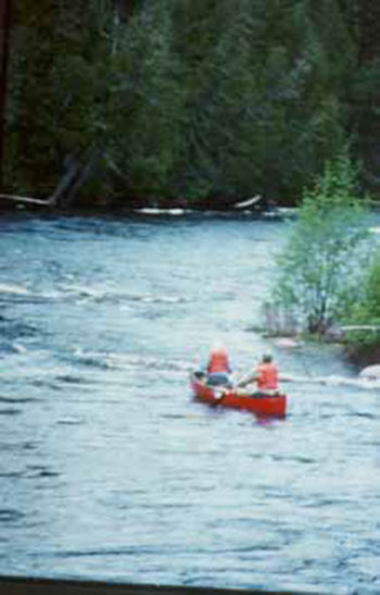
Image of the Paddling the Missinaibi
6.0 Park boundary (map section)
The park was originally established in 1970 as Missinaibi Lake Provincial Park and at that time it included only part of Missinaibi Lake, while the Missinaibi River and Little Missinaibi Lake were designated as park reserve. In 1989 the park boundary was amended by Ontario Regulation 256/89 of the Provincial Parks Act and included Missinaibi, Little Missinaibi and Brunswick Lakes, and the Missinaibi and Brunswick Rivers. The park presently encompasses 87,293 hectares.
Ontario’s Living Legacy Land Use Strategy (1999) identifies three park additions
Boundary concerns have been identified over the years related to the park’s viewscape, significant resource values along the boundary, and the ecological integrity of the waterway. These areas have been identified during earlier stages of the management planning process. Park additions were reviewed by the Provincial Parks Council and approved by the Minister of Natural Resources during previous planning stages. These boundary additions
7.0 Zoning (map section)
Waterway class parks may contain six possible land use zones: access, development, nature reserve, natural environment, historical and wilderness. Each zone permits certain land-uses in accordance with park management policies. These zones will guide the protection, management and development of Missinaibi Provincial Park. The zoning maps delineate these zones which are distinguished by their ecological protection and management needs, permitted levels of recreational use, and degree of access and development.
Ontario’s Living Legacy Land Use Strategy (1999) encompasses Missinaibi Provincial Park as far north as the Pivabiskau River and northeast to the McBrien/Garden Township boundary. Management of the park’s resources, permitted activities and the zoning that identifies this management are subject to policies in Ontario’s Living Legacy Land Use Strategy (1999) and Ontario Provincial Parks Planning and Management Policies (1992) within that area. Missinaibi Provincial Park, north of the OLL Planning Area (Figure 1) is subject to Ontario Provincial Parks Planning and Management Policies (1992). Policies specific to Missinaibi Provincial Park can be found in this park management plan (Sections 8-10).
Natural heritage education, interpretive, research, recreation, and operations facilities may be provided. Prescriptions will be prepared for each zone in the park operating plan (Section 9.0).
The OLL Park Additions (P1542, P1543 & P1544) identified in Ontario’s Living Legacy Land Use Strategy (1999) are zoned natural environment until further information (e.g. species at risk, life science, earth science) is gathered. In the event that these areas require a higher degree of protection (e.g. wilderness or nature reserve zone) a major amendment to this park management plan will be completed (Sections 7.1 NE2-b, NE3-b & NE7-b).
7.1 Natural Environment zones
Natural environment zones include natural and scenic landscapes of the park in which there is a minimum level of development required to support low-intensity recreational activities. A variety of recreational activities will be permitted ranging from motorized travel to canoeing, hunting (outside the Chapleau Crown Game Preserve), hiking and backcountry camping.
NE1 Missinaibi Lake (map 1)
This zone contains all of Missinaibi Lake, nearly forty kilometres long, as well as the surrounding shoreland with many small lakes and streams in a boreal upland landscape. It is the largest zone in the park offering excellent water-based recreational opportunities in a picturesque natural environment. Missinaibi Lake is well known for its fishing opportunities.
This zone is located within the Chapleau Crown Game Preserve, therefore hunting and trapping are not permitted (Section 8.1.9). Three private patents are surrounded by this the zone (Sections 8.1.6 & 8.1.7). Missinaibi Lake surrounds the Fairy Point Pictographs (H1) and Snake Arm Bay (Section 7.2- H2) Historical Zones, the Reva Island Nature Reserve Zone (Section 7.3-NR1) and the Barclay Bay Campground Development Zone (Section 7.6- D1).
NE2 Quittagene Rapids (maps 1 & 2)
This zone begins at the outlet of Missinaibi Lake and takes in the Missinaibi River corridor north to Peterbell. The Canadian National Railroad (CNR) forms the north boundary. This zone includes Quittagene, Cedar, Long and Barrel Rapids as well as the confluence of the Hay River. Along this section there are remnants of logging activities from the early 1900s.
Canoeing is the most popular activity here with sport fishing and backcountry camping also occurring. The Missinaibi River is part of the Quittagene Rapids Natural Environment Zone, which flows through the Hay River Nature Reserve Zone (Section 7.3-NR2) and is located within the Chapleau Crown Game Preserve.
NE2-b Missinaibi-Hay River (map 1)
Missinaibi-Hay River Addition (P1542) is identified in Ontario’s Living Legacy Land Use Strategy (1999) and is regulated as part of Missinaibi Provincial Park (Section 6.0). The OLL Addition encompasses 2,307 hectares and includes portions of the Hay River wetlands, shallow to deep marsh lands and scattered hardwood and mixed wood stands along upland and river bank areas. Lacustrine deposits dominate the Missinaibi and Hay rivers. There are approximately twenty-four species that are of significance to the flora of the Clay Belt; nine are new records while the rest are considered rare or scarce.
Coinciding with the wetland along the Hay River, one finds the best example of cedar swamp community in the vicinity of the park. This complex will be assessed and mapped. Strategies for protection of the natural heritage features will be developed. Nature reserve zones will be defined, as appropriate, through further field research to identify significant plant communities. Accordingly, a major amendment to this park management plan will reflect any change in zoning.
This zone is located within the Chapleau Crown Game Preserve, therefore hunting and trapping are not permitted (Section 8.1.9).
NE3 Swamp Portage Rapids (map 2)
This zone begins near Swamp Portage Rapids, north of the Canadian National Railway (CNR) at Peterbell and follows both sides of the main river channel. The section from Swamp Portage Rapids to the Fire River incorporates the Missinaibi River, including the mouth of the Greenhill River, which is one of the most scenic stretches on the Missinaibi River. The Missinaibi River, north of Swamp River Portage includes some of the better quality whitewater canoeing in the park. Canoeing and associated backcountry camping are the primary activities here.
NE3-b Missinaibi-East Addition (maps 2 & 3)
Ontario’s Living Legacy Land Use Strategy (1999) identifies the Missinaibi-East Addition (P1543) to be added to Missinaibi Provincial Park. This OLL Addition encompasses approximately 26,848 hectares and consists of lacustrine deposits mixed with dense conifer, mixed deciduous and sparse forest. The OLL Addition stops at the Ericson/Cromlech Township boundary.
NE4 Fire River (maps 2 & 3)
This zone begins at the confluence of the Fire and Missinaibi Rivers and encompasses the mouth of the Fire River and the Missinaibi River north to the Abbott/Rykert Township boundary, which includes the Camp 95 bridge on the Missinaibi River (Section 7.5-A6). This section of the Missinaibi River is very scenic. Canoeing, backcountry camping and sport fishing occur in this section of the waterway (Sections 8.0-9.0).
NE4-b Missinaibi River (maps 2 & 3)
The park boundary along the Missinaibi River will be expanded from the high water mark to 200 metres inland in accordance with established provincial park policy for waterway parks (Provincial Parks Council Recommendations and Minister’s Responses, 1994; Preliminary Park Management Plan (1994 & 2003, revised).
NE5 Brunswick Lake and River (maps 2 & 3)
This zone includes the historic Brunswick Portage linking Brunswick Lake on the south end to the Missinaibi River, the islands, shorelands and all of Brunswick Lake, Foster Lake, and the Brunswick River flowing into Missinaibi River. The pine-covered granite islands on Brunswick Lake offer a scenic change from the river environment where the forest characteristically overhangs the banks.
Brunswick Lake offers a variety of recreation opportunities for small craft boating (Section 9.2.1), canoeing, backcountry camping and is noted for its fishing. This zone includes private lands and private recreational land use permits (Sections 8.1.5, 8.1.6 & 8.1.7). Commercial tourism operations are located on patent lands on Brunswick Lake (Section 8.1.4). Access and historic zones occur within this zone (Sections 7.2 & 7.5).
NE5-b Brunswick Lake and River, Foster Lake (maps 2 & 3)
The park boundary along Brunswick Lake and River, and Foster Lake will be expanded from the high water mark to 200 metres inland in accordance with established provincial park policy for waterway parks (Provincial Parks Council Recommendations and Minister’s Responses, 1994; Preliminary Park Management Plan (1994 & 2003, revised).
Area will be added to the park to protect the following values (Provincial Parks Council Recommendations and Minister’s Responses, 1994, Preliminary Park Management Plan, 1994 & 2003 revised):
- to bring all of Brunswick Lake in Puskuta Township within the park to ensure uniform application of park policies and to protect the south west arm of Brunswick Lake which extends into a rich wetland environment
- to include nesting sites of Osprey, Great Blue Heron and the provincially endangered Bald Eagle
- to include a series of pothole lakes adjacent to and in close proximity of Brunswick Lake in Ericson Township
- to manage lines of sight associated with three peninsulas on Brunswick Lake according to provincial park policy
- to maintain a minimum 200 metre boundary around the lakes, adjacent wetlands and riparian forest; and
- to include area around Doherty Creek wetlands to ensure the ecological function of those wetlands
NE6 Two Portage Falls (maps 3 & 4)
This zone begins at the Abbott/Rykert Township boundary and includes the Missinaibi River to Crow Rapids, south of the Highway 11 crossing at the Municipality of Mattice-Val Côté. Until recently, much of this section of river was bounded by patent lands and as such the park had little or no shoreline along the Missinaibi River. Four townships were acquired by MNR in 1999 through a land trade (refer to NE6-b).
This section of the park links to the south end of the Mattice-Val Côté Development Zone (Section 7.6- D2).
This zone is scenic and offers recreational opportunities such as motorboating, canoeing, sport fishing and backcountry camping (Sections 8.0- 9.0).
NE6-b Rykert, Orkney, Magladery, Staunton, Eilber and Devitt Townships (maps 3 & 4)
Four townships, Rykert, Orkney, Magladery and Staunton were under private ownership for many years. The Government of Ontario acquired these private lands through a land trade. There are geological features on the adjacent lands that were acquired south of Mattice that could be considered in the future, through a major amendment, as nature reserve zones (Section 7.3). As such the park boundary will be increased from the regulated boundary at the high water mark to comply with minimum waterway park boundary standards. The minimum standard for waterway class parks is 200 metres and greater where there are significant values to be protected (e.g. nature reserve- earth/life science features). The Missinaibi Preliminary Park Management Plan (1994 & 2003 revised) identified the addition and this park management plan confirms MNR Ontario Park’s intent to add this area to the park.
Private landowners adjacent to the Missinaibi River in Eilber and Devitt townships, within the Municipality of Mattice-Val Côté, will be encouraged to manage their shorelines for conservation purposes (Appendix II). Where the property contains values that contribute to the park’s objectives and an opportunity exists (e.g. a property is for sale), Ontario Parks may acquire private land on a willing seller/willing buyer basis as funding permits.
NE7 Rock Island Portage (maps 4 & 5)
This zone begins at Rock Island Portage, north of Mattice-Val Côté and takes in the Missinaibi River corridor to where the river branches to the east, feeding into the Coal River and just upriver from Thunder House Falls. This section of the Missinaibi River is scenic and offers an outstanding recreational setting for canoeing, fishing and backcountry camping (Sections 8.0-9.0). Motorboating occurs here as water levels permit (Section 9.2.1). In this section of the park, old road beds going north from Mattice parallel the waterway to provide access (A8) (Section 7.5).
NE7-b Missinaibi-Thunder House Falls Addition (map 6)
Ontario’s Living Legacy Land Use Strategy (1999) identifies the Missinaibi-Thunder House Falls Addition (P1544) to be added to Missinaibi Provincial Park. This roadless addition encompasses approximately 20,719 hectares and contains broken ground moraine and organic deposits under dense conifer. The OLL Addition consists of rivers, wetlands and rapids and is considered transition between the Canadian Shield and Hudson Bay Lowlands.
This OLL Addition encompasses the Thunder House Falls Wilderness Zone (W2). A portion of the OLL Addition is located to the east and south of the Coal River, in Scovil, McLeister and McBrien Townships. The remaining portion of the OLL Addition is located to the west and north of the Missinaibi River, in Scovil, Burstall and McBrien Townships. The northern boundary of this OLL Addition follows the Pivabiskau River. This OLL Addition has good potential, in whole or in part, to be added to the wilderness zone (W2) and compliment the wilderness values of that zone. Future planning will assess this opportunity, as well as any nature reserve zoning opportunities (Section 11.0). Accordingly, a major amendment to this park management plan will reflect any change in zoning (Sections 7.4, 8.1.9 & 9.2).
The topography in this section includes the northern edge of the Canadian Shield and the overlying deposits of the Hudson Bay Lowlands as evident from the continuous incising action of the Missinaibi River cutting through extensive glacial deposits of sand and clay. These deposits are visible today in the steep river banks. Where smaller creeks enter, the skyline views extend further inland. In other areas the banks have reached an equilibrium where they gradually slope up and away from the Missinaibi River for perhaps as much as 200 metres before they crest.
NE8 Lowlands (maps 6 & 7)
Beginning at the north confluence of the Coal and Missinaibi Rivers, this section of the Missinaibi River drops into the Hudson Bay Lowland flowing into the Moose River and ending at Moose River Crossing where it is crossed by the Ontario Northland Rail (ONR) line. Canoeing and backcountry camping continue to occur here. Motorboats may be found travelling from the Opasatika River to Moose River Crossing for sport fishing and other recreational pursuits (Section 9.2.1). This natural environment zone flows through nature reserve zones (Section 7.3 NR5, NR6, NR7 & NR8) along the Missinaibi River’s shores, which highlight four striking geological features. The northern most community of white elm with black ash, for this part of Ontario, is found on an island (NR9) in the Missinaibi River. There is a historical zone (Section 7.2-H6) at the mouth of the Pivabiskau River. The portion of the Pivabiskau River that flows through the historical zone is part of this natural environment zone. The community of Moose River Crossing is outside the park boundary.
NE8-b McBrien Township (map 6)
A small section of Missinaibi Provincial Park in McBrien Township, an area approximately coinciding with NR6 (Section 7.3), was within a mining lease (CLM12). The lease has expired and a consistent park boundary through this area will be established to retain the significant natural feature. The portion of the addition adjacent to NR6 will be added to the nature reserve zone (Section 7.3). The boundary will not be expanded beyond 122 metres within the old lease area to maintain mineral potential in an area of clay and silica deposits (Recommendation #98, Provincial Parks Council Recommendations and Minister’s Responses, 1994; Preliminary Park Management Plan, 1994 & 2003 revised).
The Missinaibi River, in the southern portion of McBrien and Garden Township was not included as part of the Missinaibi-Thunder House Addition (P1544), however this portion was identified in the Missinaibi Provincial Park Preliminary Management Plan (1994, 2003 revised). This park management plan confirms MNR Ontario Parks intent to add this area to the park (Provincial Parks Council Recommendations and Minister’s Responses, 1994, Missinaibi Preliminary Park Management Plan (1994, 2003 revised).
NE8-b Pivabiskau River to Moose River Crossing (maps 6 & 7)
In Habel Township, the Ministry of Natural Resources has acquired 247 hectares of patent land adjacent to the Missinaibi River. The minimum boundary identified in provincial park policy for waterway class parks is 200 metres. Within this area, the park boundary will be expanded to a minimum of 200 metres on either side of the Missinaibi River.
The remaining section of the Missinaibi River from Habel Township to the park’s northern boundary will be expanded to 300 metres on either side of the Missinaibi River, except at the community of Moose River Crossing (Provincial Parks Council Recommendations and Minister’s Responses, 1994; Preliminary Park Management Plan, 1994 & 2003 revised). This area will be zoned natural environment, with corresponding increases to NR8 and NR9 (Section 7.3).
Four private patents, near Moose River Crossing incorporate a significant geological feature that represents two sequences in Ontario’s geological history. Here, an outstanding exposure of the Missinaibi Formation and its plant and animal fossil record will represent deposits formed some seventy thousand years ago when a large saltwater sea covered the area. Also, a distinctive gypsum exposure is found here, being formed some 350 million years ago during the Devonian era.
The Ministry of Natural Resources will seek to acquire property that contains values that contribute to the park’s objectives, near Moose River Crossing. Ontario Parks may acquire private land on a willing seller/willing buyer basis and as funding permits, to establish a 300 metre shoreline boundary in this area (Provincial Parks Council Recommendations and Minister’s Responses, 1994; Preliminary Park Management Plan, 1994 & 2003 revised). In the interim, Ontario Parks will seek to establish a conservation agreement with the landowner(s) to sustain the natural features of the site (Appendix II).
7.2 Historical zones
Historical zones represent significant cultural heritage values that require special management. Management of these values may provide opportunities for visitors to learn about and appreciate the cultural heritage of this part of Ontario. Day-use activities (e.g. fishing, canoeing) are permitted, but camping is not permitted and no structures will be built in historical zones.
H1 Fairy Point Pictographs (map 1)
More than 100 Aboriginal rock paintings or pictographs are found along a spectacular cliff face at Fairy Point on Missinaibi Lake. This special landscape has south facing slopes with shallow rocky soils on the lakeshore and includes a ten hectare red and white pine stand; some individual trees are 350 years of age.
Image of the Picture writing, ancient pictographs

H2 Snake Arm Bay (maps 1 & 8)
Located on a point adjacent to Barclay Bay Campground (Section 7.6-D1), this zone contains a significant archaeological site. Research has indicated possible use of the site for some 2,000 years.
H3 Missinaibi Lake (map 1)
This zone represents the site of a Hudson’s Bay Company (HBC) post that operated on Missinaibi Lake, known by different names over a span of 140 years. At one point the post was burned down and the operations were moved to Wapiscogamy. The post was used periodically from 1777 to 1821 and then closed. The site was reopened as a post from 1873 until 1917. This was the last operating HBC Post along the Missinaibi. After the Brunswick Lake location closed, Missinaibi Lake post was known as New Brunswick House (see H4).
H4 New Brunswick House (map 3)
Brunswick Lake is the most significant historical fur trade location in the park. It was the site of the HBC's longest operating post on the Missinaibi River, from 1789 to 1879. HBC records identify this as their New Brunswick House post, the primary trading post along the Missinaibi. However, the rival North West Company (NWC) also viewed Brunswick Lake and the HBC location as strategically important and opened a NWC Post on the Lake shortly after the HBC began operating there. NWC documents indicate that trading occurred here until 1803, closed for a period and then reopened from 1812 until the merger with the HBC in 1821. An Aboriginal fishing camp was located here to supply these posts. This site is very representative of the overlapping, and intense rivalry for trade between the two opposing fur trade companies that relied on Aboriginal peoples and their ancient travel routes in the struggle to control the 'pays du nord'. After the HBC merged with the NWC, all other posts on the Missinaibi River were closed showing the importance placed on the Brunswick Lake location. The site remained an HBC Post until 1879, when it was abandoned and the name New Brunswick House was transferred to an HBC Post that was opened on Missinaibi Lake (see H3).
H4-b New Brunswick House (map 3)
This zone will become part of H4 as it includes a portion of the historic area, which is not presently in the park. This area is a portion of an important historical site within the park (see H4). This zone also includes the remaining portion of a designated Wilderness Area (Wilderness Areas Act, R.R.O. 1990, Reg. 1098, Sched. 2).
H5 Coal River (map 6)
This zone features what is regarded as a NWC Post dating back to approximately 1800. It is located adjacent to the northern limit of the Thunder House Falls Wilderness Zone (Section 7.4-W2). This section of the Coal River is included in this zone.
H6 Wapiscogamy (map 6)
This zone marks the former site of the Wapiscogamy House HBC trading post. This site is recognized as the first inland HBC Post on the Moose/Missinaibi River system. HBC operated a post from 1776 to 1791. The zone also includes the site of a NWC Post that was built less than one kilometre downstream from the HBC site and operated from 1800 to 1806. The Pivabiskau River is not part of this zone (Section 7.1-NE8).
7.3 Nature Reserve zones
Nature reserve zones include the park’s most significant biological or geological features that may require management distinct from that in adjacent zones. The nature reserve zones within Missinaibi Provincial Park are on land and do not include the Missinaibi River, which is a natural environment zone. Some minimum impact recreational activities, such as hiking, are acceptable provided there is no potential for the features to be impacted. Hunting, trapping, backcountry camping and motorized travel are not permitted in nature reserve zones (Sections 8.0-9.0).
NR1 Reva Island (map 1)
Preserved from fire by its island location, this zone contains a stand of red and white pine, some known to be at least 350 years old. A regionally significant archaeological site is also found on this island (Section 8.3).
NR2 Hay River Cedar Swamp (map 1)
This zone has plant communities ranging from open water to bare rock outcrops. The area hosts the best example of cedar swamp communities found along the Missinaibi River. The swamp is particularly rich in flora.
Image of the Hay River Wetlands
NR3 Peterbell Wetland (map 2)
This zone is centered on one of the most southerly string bogs in Ontario and contains many plant species considered rare or scarce in this part of the Province. The Missinaibi River itself flows through the nature reserve and is zoned natural environment (NE2). The marsh/swamp complex is an ecologically significant area of the Missinaibi River. The zone has high interpretive value since some plants here mark transitions and successions from open water to dry ridge-top environments. Also significant is the natural levee system that was formed during the drainage of post-glacial Lake Barlow-Ojibway during the latter stages of Late Wisconsinan deglaciation, some 8,000 to 10,000 years ago.
NR4-b Doherty Creek Wetlands (map 3)
This addition protects the Doherty Creek wetlands on the west shore of Brunswick Lake, and extends 200 metres from the tree line around wetlands and creeks (Provincial Parks Council Recommendations and Minister’s Responses, 1994; Preliminary Park Management Plan, 1994 & 2003 revised). A wide variety of bird life occurs in this wetland, which is also an excellent moose viewing area and a critical walleye spawning and nursery area.
NR5 Elm and Ash Island (map 5)
Located on a small island just north of Alice Island, this zone has a small community of black ash and very large elm. Associated species that occur here are considered uncommon at this latitude.
NR6 Cretaceous Marine Sediments (map 6)
This zone protects horizontally interbedded Cretaceous deposits of unconsolidated white silica sand, kaolinite and red and grey fire clays. These Mesozoic-aged deposits (approximately 100 million years old) of northeastern Ontario are rare. Only a few other similar exposures are known in Ontario.
This zone will extend no further than 122 metres from the river in order to maintain mineral potential outside the park (Provincial Parks Council Recommendations and Minister’s Responses, 1994; Preliminary Park Management Plan, 1994 & 2003 revised).
NR7 Quaternary Glacial Drift (map 6)
This zone contains an exposure that records the last 350,000 years of physical evolution of northeastern Ontario. It is the most complete Quaternary stratigraphic sequence (approximately 190,000 years old) exposed at one location in the Moose River Basin. This feature marks some of the oldest glacial deposits in Ontario.
NR7-b Quaternary Glacial Drift (map 6)
This is an addition to NR7 taking the boundary out to the 200 metre minimum standard for waterway class parks, protecting nature reserve values (Provincial Parks Council Recommendations and Minister’s Responses, 1994; Preliminary Park Management Plan, 1994 & 2003 revised).
NR8 Moose River Basin Inter-till Fossil Deposits (map 6)
This zone protects a deposit representative of the youngest non-glacial, inter-till unit in the Moose River Basin. Also within this zone is an abundance of large plant fossils from an ancient interglacial boreal forest that once existed in the area some 100,000 years ago.
The section of the Missinaibi River in Habel Township will be expanded to 200 metres on either side of the Missinaibi River (NR8-b), (Provincial Parks Council Recommendations and Minister’s Responses, 1994; Preliminary Park Management Plan, 1994 & 2003 revised) (Section 7.1-NE8-b).
NR9 Hudson Bay Lowland Marine and Fossil Deposits (map 6)
The marine fossils found at this site are the only evidence on the Missinaibi River of the earliest known interglacial marine invasion of the Hudson Bay Lowland, which occurred some 135,000 years ago.
The section of the Missinaibi River in Habel Township will be expanded to 200 metres on either side of the Missinaibi River (NR9-b), (Provincial Parks Council Recommendations and Minister’s Responses, 1994; Preliminary Park Management Plan, 1994 & 2003 revised) (Section 7.1-NE8-b).
NR10 Northern Elm and Ash Island (map 7)
This zone protects an island white elm-black ash community that is the most northerly location of elm known for this part of the Province.
7.4 Wilderness zones
Wilderness zones include large remote areas of land and water along the Missinaibi River. Wilderness zones are managed to allow natural processes to function freely and to permit visitors to enjoy the outdoors by experiencing solitude, self-reliance and challenge. Backcountry camping is allowed on designated campsites and motorboat use is permitted only through existing commercial tourism services in Little Missinaibi Lake Wilderness Zone (W1).
Snowmobiles, ATVs and aircraft are not permitted in wilderness zones (Sections 8.0-9.0).
W1 Little Missinaibi Lake (map 1)
This zone’s main feature is Little Missinaibi Lake and also includes Elbow Lake, Trump Lake, and the Little Missinaibi River. This wilderness zone fulfills the provincial requirement to represent Ontario’s Lake Abitibi Ecoregion, 3E
This zone is located within the Chapleau Crown Game Preserve therefore hunting and trapping are not permitted. This zone is also located in the Quality Fisheries Zone identified in the Chapleau District Fisheries Management Plan (Sections 8.2.2, 9.2.1 & 9.3.3). Road access, including tributary roads and trails, to Missinaibi Provincial Park are restricted under the Public Lands Act (sec. 26). Vehicle use of these roads / trails to access Missinaibi Provincial Park is prohibited (Sections 9.2.1).
Existing commercial uses in this zone include two outpost camps and three boat caches (authorized by land use permit) and motorboat travel for commercial guests. Commercial outpost camps pre-existed the Little Missinaibi Lake addition to the park (1988). These LUPs, including air access, will be permitted to continue, however will be reviewed in the future (Sections 8.1.4, 9.2.1, 9.3.1 & 9.5).
W2 Thunder House Falls (map 6)
This zone is an unroaded area between the main Missinaibi River and the Coal River. This section of the Missinaibi River is also zoned wilderness. The most striking feature in this zone is the outstanding geology and scenery of Thunder House Falls. The zone contains the best example in Ontario of a major river flowing through the point of contact between the Canadian Shield and the Hudson Bay Lowlands. Its spectacular gorge reveals rock weathering formations with a rare exposure of the actual contact between the Precambrian bedrock of the Canadian Shield and the Cretaceous bedrock of the Hudson Bay Lowlands. A visible vegetation transition between the boreal forest and the lowlands is evident here. These combined features are a definite highlight for travellers following ancient portages around impassable rapids along this section of the Missinaibi River. All existing portages and campsites will continue.
The Missinaibi-Thunder House Falls Addition (P1544) is zoned natural environment (Section 7.1- NE7-b). This zone has potential, in whole or in part, to be added to this wilderness zone. Future planning will assess this opportunity, as well as any nature reserve zoning. Accordingly, a major amendment to this park management plan will reflect any change in zoning.
7.5 Access zones
Access zones in provincial parks are the managed points of entry to recreational opportunities for the park visitor. A minimum of facilities such as roads, bridges, parking lots, docks or information kiosks may be developed according to approved site plans to service park access at these specific locations. Hunting is not permitted. Walk-in and boat-in camping may be permitted.
A1 Barclay Bay Road (map 1)
This zone provides road access to the Barclay Bay Campground (D1), which includes thirty-six campsites with supporting infrastructure and a boat launch providing access to Missinaibi Lake.
A2 Peterbell (map 2)
This area is adjacent to the railway where canoeists access the Missinaibi River to start a six to ten day canoe trip on the upper Missinaibi River. Camping is permitted.
A3 Byng Creek (maps 2 & 3)
This day-use access on the southwest end of Brunswick Lake is via an abandoned portion of the Caithness Road system (CSR8 Levesque). This road provides access to a location on Byng Creek outside of the current park boundary. This location provides access to day-use boating and angling opportunities, and interior camping on Brunswick Lake (Sections 8.2.2, 9.2.1 & 9.3). Camping is not permitted in this zone.
A4 Brunswick Lake (map 3)
An access point exists on the northwest shore of Brunswick Lake. This access may be developed with appropriate facilities (e.g. parking, launching facilities, etc.). A site plan will be prepared, standards and appropriate facilities identified, and designed. MNRs environmental assessment requirements and standards must be met.
Development and maintenance of this access point may be carried out through a partnership. Ontario Parks will work with Fish & Game clubs and other interested parties to identify, develop and maintain this access (Section 9.3).
A5 Brunswick River (map 3)
Some access to Brunswick Lake occurs at this site, on the east shore of the Brunswick River. A trail connects this access with a logging road known as CSR7a. Access here is limited and receives low use.
This access will be assessed and monitored for its current suitability, site conditions and level of use.
A6 Camp 95 Bridges (map 3)
The bridges crossing the Missinaibi and Brunswick Rivers at this location have been used by canoeists and boaters as an access point. Access to this location is dependent upon the condition of the logging roads (Section 9.4).
A7 Glassy Falls (map 4)
Glassy Falls provides an access point to the Missinaibi River for activities such as day trips, camping, and canoeing. This area is part of the adjoining four townships (Rykert, Orkney, Magladery and Staunton), that have been acquired from a local forest management company (Section 7.1-NE6-b). Camping occurs in this zone. Access to Glassy Falls and management needs will be assessed
Unauthorized all terrain vehicles (ATVs) use passing over the historic portage and along the shoreline are eroding this site. The land beyond the high water mark was acquired (see NE6-b) at Glassy Falls to establish a park boundary at a minimum of 200 metres from shore, on either side of the Missinaibi River. Management options developed for Glassy Falls will be reviewed through a plan amendment, which will address boundary refinement within the four townships. Site planning will establish measures for site rehabilitation and maintenance (Sections 9.2, 9.3 & 10.1).
A8 Rock Island Falls (maps 4 & 5)
This is a popular access point for area residents on the west side of the Missinaibi River between Rock Island Falls and Black Feather Rapids. It consists of a steep, one-lane gravel boat ramp. Parking occurs on the adjacent municipal road (Section 9.3).
A9 Skunk Island (map 5)
This is a popular access point for area residents, particularly during spring when water levels are high enough to permit boat and motor use (Section 9.3).
A10 Bells Bay (map 6)
Commercial and private aircraft will be permitted to land at Bells Bay (Section 9.3.1). Commercial and the private use of motorboats are permitted in this zone, however not between June 15 - August 31 (Section 9.2.1). All other uses and activities will conform to those of the surrounding wilderness zone (Sections 7.4-W2). The intent is to facilitate access for canoeing.
Image of the Bells Bay
A11 Crooked Lake (map 1)
This access zone is located where the canoe route from the Michipicoten River and Dog Lake enters the park. The Michipicoten River and the Missinaibi River are connected by a short portage across the "height of land" between the Great Lakes and Hudson Bay watersheds. The canoe route receives occasional use, providing alternate canoe access to Missinaibi Lake. Motorized use is not permitted.
A12 Elbow Lake (map 1)
The Shumka canoe route enters the park at this access zone on the edge of the Little Missinaibi Lake Wilderness Zone (W1). Canoeists may start this canoe route at the Shumka railway stop on the CPR line. Portages link Elbow Lake to the Little Missinaibi Lake. Motorized use is not permitted, at the access zone or to the wilderness zone beyond (Sections 7.4 & 9.2).
7.6 Development zones
Development zones provide access to the park, and facilities and services for a range of day-use and camping activities. Normally development would be considered where larger numbers of people use an area of the park or might be expected to benefit from development. In all cases, significant natural and cultural features must be protected prior to any development. Hunting and trapping are not permitted. Barclay Bay is within the Chapleau Crown Game Preserve and Mattice-Val Côté contains residential space, the CNR line and Highway 11.
D1 Barclay Bay Campground (maps 1 & 8)
This zone contains a developed campground with thirty-six campsites and associated support facilities on Missinaibi Lake. The park’s operational centre is located here, consisting of maintenance and staff facilities, and a forest fire management "forward attack base". A boat launch provides access to Missinaibi Lake (Section 10.2).
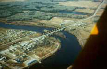
D2 Mattice-Val Côté (maps 4 & 5)
The park boundary within this development zone follows the high water mark, with the exception of three small areas where the boundary extends beyond the high water mark. This zone is the most popular entry/exit point on the Missinaibi River.
Most adjacent lands are under private or municipal ownership. A municipal park provides river users and tourists access to services such as camping and a comfort station with showers.
Interpretive opportunities will be considered adjacent to this zone, to complement municipal proposals for heritage appreciation associated with the Aboriginal and fur trade travel. This would service local clientele and Missinaibi River users, as well as attract Highway 11 travellers (Section 10.3).
Image of the Mattice – Highway 11 & CNR Line
8.0 Resource stewardship policies
Missinaibi Provincial Park will be managed in accordance with Ontario’s policies for provincial parks. Direction is provided in this section to integrate protection and management of the park’s resources. Although resource policies are described under various headings, all planning and management will recognize that these components are interdependent in the context of the park and the related surrounding landscape.
The 501 kilometre Missinaibi Provincial Park is located, in part, within Ontario’s Living Legacy Planning Area and is therefore subject to policies in Ontario’s Living Legacy Land Use Strategy (1999) and Ontario Provincial Park Planning and Management Policies (1992). Ontario’s Living Legacy Land Use Strategy (1999) determines some resource management policies for Missinaibi Provincial Park. Policies for the portion of Missinaibi Provincial Park within the OLL planning area (Figure 1 & Map 6) and park additions (P1542, P1543 & P1544) are defined within this park management plan and Ontario’s Living Legacy Land Use Strategy (1999). Policies for the portion of Missinaibi Provincial Park north of the OLL planning area are defined within this park management plan and Ontario Provincial Park Planning and Management Policies (1992).
The Crown Land Use Policy Atlas (CLUPA) is MNR's repository of existing local land use policies for Crown lands in the central part of Ontario, including provincial parks. Amendments to the policy reports and mapping of the CLUPA will be completed to reflect the direction of this park management plan (Section 11.0).
8.1 Terrestrial ecosystems
Terrestrial ecosystems
8.1.1 Adjacent land management
Strategies for adjacent land management were developed and presented to the public in the Missinaibi Provincial Park Preliminary Management Plan (1994 & 2003 revised). Public input, including that from forest companies, has resulted in these strategies.
Forest management planning and forest operations adjacent to the park
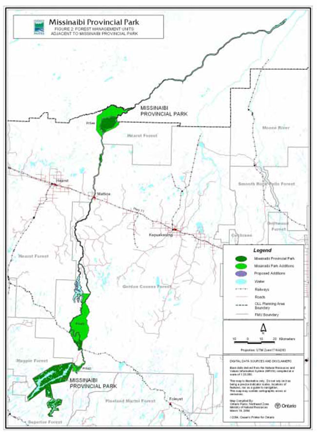
Commercial timber harvesting is not permitted within the park. Harvesting will occur in the forest management units adjacent to the boundary of Missinaibi Provincial Park. There are five management units including: Superior Forest, Magpie Forest, Gordon Cosens Forest, Hearst Forest and Moose River (Figure 2).
Forest communities, constituent species and site characteristics change significantly over the length of the park. The biodiversity that exists now around the waterway corridor is the result of broad ecological responses from the interplay of natural and human disturbances. Strategies to sustain the biodiversity should integrate park values with forest harvest practices on the Crown landbase. Park lands will reflect the results of natural succession and disturbances along the length of the waterway. Practices on the adjacent managed Crown landbase will have regard for park values. The variety of approaches to harvest and renew the adjacent forests may include some prescriptions that are based in part on natural disturbance processes and patterns in the forest.
During forest management planning and operations, protection of park values
The following modifications to forest operations should be considered in respective forest management plans as a minimum. Specific details should be reviewed with the public during forest management planning.
Areas of Concern (AOC)
Where the park boundary is less than 400 metres from Missinaibi Lake, Little Missinaibi Lake, Missinaibi River, Coal River, Brunswick Lake or Brunswick River, an AOC of varying width may be established. This would ensure that the distance to the water’s edge, including the park and AOC, would never be less than 400 metres.
In some cases, large harvest blocks have been permitted in boreal forest operations. The public and conservation groups raised concerns in the past with respect to these harvest blocks that resulted in narrow fringes of trees adjacent to the park. Ontario Parks will participate in forest management planning to ensure these concerns are addressed. Allocations should be designed to protect park values and adhere to the Natural Disturbance Pattern Emulation Guidelines.
Scenic hillsides beyond the park boundary should be mapped. In some instances they may lie beyond 400 metres of the main waterway. Criteria for analysis of this "viewscape" may be developed in conjunction with forestry companies operating adjacent to the park. Prescriptions to ensure the maintenance of the scenery should be considered in the forest management planning process for public review.
All season gravel roads should be located with the intention of preventing unplanned access to the park, while retaining flexibility for forestry operations. Minimum distances for roads from the park boundary should be considered in forest management plans. The Ministry (including Ontario Parks staff) should carefully review road locations (Appendix I).
Careful consideration should be given to scheduling the time of road construction, harvest and renewal and maintenance operations to minimize activities within 1.6 kilometres of the Missinaibi Provincial Park boundary during the period of high park use (June 1 to August 31). Consideration should be given to locate permanent and seasonal forestry work camps at least 1.6 kilometres from the park boundary.
Aerial herbicide applications may be undertaken for forest renewal purposes adjacent to the park boundary in a manner that does not affect park values. Spray buffers should be established in forest management plans to protect park values. The size of buffers would be determined by the nature of the values, site conditions, boundary configuration and relevant local variables. Annual aerial tending programs should outline specific prescriptions to minimize disturbance to the park user based on timing and specific site conditions. Alternative methods of vegetation control that provide a broader range of options close to parks and other values should be considered where feasible.
The Park Superintendent will work with MNR District staff and the forest companies to ensure that park values are considered during forest management planning (Section 11.0).
8.1.2 Vegetation management
A vegetation stewardship plan will be prepared for Missinaibi Provincial Park (Section 11.0). It will prescribe appropriate techniques for rehabilitating erosion caused by land use such as unplanned access points, discontinued road crossings or surrendered previously alienated lands, etc. within the park. Vegetation planning will also deal with important life science features and other vegetation related park values such as lines of sight or campground needs, by identifying concerns and prescribing appropriate solutions.
Forest fires
MNR and Ontario Parks recognize fire as an essential ecosystem process, fundamental to restoring and maintaining the ecological integrity of protected areas in the Great Lakes – St. Lawrence and Boreal Forest Regions.
As part of implementation planning following the preparation of this park management plan, fire management planning will be undertaken in co-operation with MNR's fire program (Section 11.0). This fire management plan will further develop objectives and protection priorities, and guide implementation through fire response and fire use. The plan will advance the use of fire to meet ecosystem management objectives while ensuring the appropriate response to forest fires to prevent personal injury, value loss, and social disruption. The plan will examine the historical role of fire in the ecodistrict, and its potential beneficial effects, particularly with regard to forest succession and the rejuvenation of white pine. The plan will also identify management and protection priorities relating to the use of fire, fire prevention, and suppression activities in and adjacent to Missinaibi Provincial Park.
In the absence of a specific fire management plan for the park, fire management will be carried out as on adjacent public lands in accordance with the Forest Fire Management Strategy for Ontario and the Zone designations (Boreal, North of Highway 11 Sub-Zone, Northern Boreal Zone, Hudson Bay Zone) identified in that strategy.
Fires that threaten park visitor safety or park infrastructure will receive full response and sustained action until extinguished. In keeping with the objectives of this plan, other fires can be considered for modified response, in consultation between the Park Superintendent and the Fire Executive Officer. Whenever feasible, the MNR fire program will endeavour to use "light on the land" techniques, which do not unduly disturb the landscape. Examples of light on the land techniques may include limiting the use of heavy equipment or limiting the number of trees felled during fire response efforts.
The technique of prescribed burning may be used to simulate natural wildfire where desirable, except in development and access zones. Prescribed burning will be addressed in the fire management plan and occur only in accordance with MNR policy and guidelines, to achieve ecological or hazard reduction objectives. A plan for any prescribed burning will be developed, in consultation with MNR's fire specialists and in accordance with the MNR Prescribed Burn Planning Manual, applicable policies and legislation which will be developed.
Insects and disease
Insects and disease may be managed where aesthetic, cultural, or natural values are threatened. Where information is found to warrant management controls, problem areas will be narrowed so as to minimize effects on other components of the park environment. Guidelines established by the Ontario Ministry of Natural Resources and the Ministry of Environment will be implemented. Biological controls will be used in preference to chemicals, where feasible.
8.1.3 Mining
There are no existing mining activities within the park.
General policy for the park and OLL additions
New mining activity, including prospecting, staking of mining claims, development of mines, or the extraction of aggregates is not permitted in Missinaibi Provincial Park.
OLL additions
Mineral exploration and mining are not permitted within the additions to Missinaibi Provincial Park (P1542, P1543 and P1544). It is noted that within the Missinaibi-Thunder House Falls Addition (Section 7.1-NE7-b, P1544), that the park boundary includes the area up to the southern shoreline of the Pivabiskau River but not the waters, riverbed, or the northern shoreline.
Figure 2: Forest Management Units Adjacent to Missinaibi Provincial Park
Mining areas adjacent to the park
The Ministry of Natural Resources will monitor mining interests on Crown land adjacent to the park on a case-by-case basis. The purpose is to identify potential negative impacts on adjacent park values. Existing legislation and regulations will be applied to address any concerns.
The Ministry of Northern Development and Mines is the lead agency in managing mineral exploration and development on Crown lands. Through Part VII of the Mining Act and Ontario Regulation 240/00, public notice must be made of advanced exploration and mineral development anywhere in the Province. In addition, such works must be rehabilitated according to a pre-approved plan, using funds set aside for the purpose before the work has begun. Existing legislation and regulations and legislation will be applied to address any concerns arising from mineral exploration and development adjacent to the park.
Renabie Gold Mines ceased operations in August 1991 and a closure plan was initiated with a three year revegetation program of the tailings and a twenty year monitoring program. The Ministry of Northern Development and Mines is the lead agency in this effort, and is conducting ongoing monitoring of the site. Any related concerns that may have an impact on Missinaibi Provincial Park and the area’s natural and cultural values will continue to be brought forward by the Ministry of Natural Resources/Ontario Parks.
Aggregate pits
There is no regulation, under the Provincial Parks Act, that permits aggregate (sand, gravel) pits within the park. Any unauthorized aggregate pits within the park will be closed and an aggregate resources rehabilitation plan will be developed and implemented to provide for ongoing rehabilitation needs (Section 11.0).
8.1.4 Commercial tourism operations
Existing commercial uses in the Little Missinaibi Lake Wilderness Zone (W1) include two outpost camps and three boat caches (authorized by land use permit) and motorboat travel for commercial guests. Non-motorized use will be encouraged. Outpost camps within this wilderness zone pre-existed the Little Missinaibi Lake addition to the park (1988). These outpost camps, including air access will be permitted to continue, however will be reviewed in the future (Section 7.4).
Expansion of tourism operations will not be permitted except through a management plan review or a plan amendment. The Park Superintendent may authorize improvements to existing facilities and services (Sections 9.5 & 10.4).
8.1.5 Hunt camps
There are two existing temporary fall camps for commercial operators in the Lowlands Natural Environment Zone (NE8). These may be permitted subject to annual renewal for the purpose of fall moose hunting. Authorized under a "restricted land use permit", specific conditions will continue to be applied to ensure the protection of park values. Such camps are normally used for a period of approximately one month.
A temporary fall camp is located within NR8 and is considered a non-conforming use in this type of zone. The Park Superintendent will identify an alternate location for the hunt camp to protect the values within this zone (Section 7.2). Approved site planning and environmental assessment requirements will be met.
8.1.6 Private recreation camps
There are three private recreation camps, under Land Use Permits (LUPs), within Missinaibi Provincial Park. In keeping with Cabinet approved provincial park policies, existing Land Use Permits within the regulated (O. Reg 256/89) boundary of Missinaibi Provincial Park will be phased out by January 1, 2010 (Ontario Provincial Parks Planning and Management Policies, 1992; Ontario’s Living Legacy Land Use Strategy, 1999).
No new LUPs for private use will be issued within Missinaibi Provincial Park.
OLL park additions
There are no existing LUPs for private recreation camps within the OLL Additions (P1542, P1543 & P1544). No new LUPs for private use will be issued.
8.1.7 Patent property
Cottages
Patent private land occurs within Missinaibi Provincial Park. Should the current owners of the three patented cottages (one is located on an island in Brunswick Lake, two on Missinaibi Lake) within the park choose not to remain on these properties they may be sold on the open market.
Lodges
There are three lodges on patent property within Missinaibi Provincial Park. Two are located on Brunswick Lake and one on Missinaibi Lake.
Ontario Parks will work with tourist operators within the park to enhance their role in providing tourism services that are compatible with, and complementary to the park. Ontario Parks will achieve this through tourism agreements (Sections 7.1-NE5 & 9.5).
8.1.8 Land disposition
No new sales of Crown land for the private use of individuals or corporations will be permitted in Missinaibi Provincial Park.
8.1.9 Wildlife management
Missinaibi Provincial Park lies within several Wildlife Management Units. Wildlife management in the park will be addressed in conjunction with MNR District wildlife management exercises. A wildlife stewardship plan will be prepared for Missinaibi Provincial Park (Section 11.0) as a means to identify specific biodiversity needs.
Existing camper education programs will be enhanced in an effort to reduce problem encounters with black bears. Animal populations may be controlled within the park when essential to protect human health and safety. Select control of animal populations will be implemented under the strict supervision of the Park Superintendent, or directly by the OMNR. Such controls will only be directed at populations requiring attention.
Hunting
Hunting is a traditional activity along the Missinaibi River, outside the Chapleau Crown Game Preserve (Map 1).
Hunting is permitted in natural environment zones (NE3, NE3-b, NE4, NE4-b, NE5, NE5-b, NE6, NE6- b, NE7, NE7-b, NE8 & NE8-b) outside the Chapleau Crown Game Preserve (north of the Canadian National Railway (CNR) line). Hunting will be permitted in the OLL Additions (P1543 & P1544), subject to future management planning which includes public consultation (Section 7.3, 7.4- W2, & see Map Section for zoning).
Hunting is not permitted in the following zones: nature reserve, access, development, historical, and wilderness zones within the park. The regulation under the Fish and Wildlife Conservation Act will be amended to reflect the above. Hunting is not permitted within the Chapleau Game Preserve. Hunting within OLL Addition P1542 will not be permitted as it is within the Chapleau Crown Game Preserve (see Map Section).
The regulation under the Fish and Wildlife Conservation Act may be amended to prohibit hunting, within the park, during the park operating season (Section 11.0).
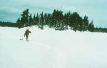
Trapping
Aboriginal people have been trapping along the Missinaibi River for thousands of years. This traditional activity attracted European explorers and fur traders in the 17th Century and the Missinaibi River was a principal route to the Hudson’s Bay Company centered on Hudson’s Bay. Through the course of preparing this park management plan, the long-standing community value and cultural heritage associated with sustainable fur trapping within the park was recognized.
Trappers will be permitted to continue to access their traplines (where trapping is allowed and licenced), including mechanized travel, within the park corridor.
Image of the Trapping – traditional winter travel
Park within Ontario’s Living Legacy planning area
Ontario’s Living Legacy Land Use Strategy (1999) states that existing commercial fur harvesting within the OLL planning area (Figure 1) will continue except in wilderness and nature reserve zones where these activities will be phased out by January 1, 2010 (Sections 7.3 & 7.4, see Map Section). Commercial fur harvesting will continue indefinitely in new OLL Park Additions (P1543 & P1544) in the OLL planning area.
Trapping is not permitted within the Chapleau Crown Game Preserve. Trapping within OLL Addition P1542 will not be permitted as it is within the Chapleau Crown Game Preserve.
The transfer of authorized traplines may be permitted. New operations, including trapline cabins and trails, will not be permitted. The relocation of existing trails and cabins will be subject to ecological principles and consideration of park values.
North of Ontario’s Living Legacy planning area
Existing commercial fur harvesting will be phased out of the park by January 1, 2010. Trapping carried out by Status Indians with Aboriginal or Treaty trapping rights will not be phased out. New operations will not be permitted. The relocation of existing trails and cabins will be subject to ecological principles and management planning.
Aboriginal use of wildlife
The Ministry of Natural Resources/Ontario Parks will work closely with Aboriginal communities, regarding First Nation use of wildlife in Missinaibi Provincial Park (Section 11.0).
Status Indians exercising Aboriginal or Treaty rights (e.g. trapping, subsistence) are permitted to continue, subject to applicable legislation and regulation.
8.2 Aquatic ecosystems management
The health of aquatic ecosystems in Missinaibi Provincial Park will be monitored. An evaluation of Missinaibi Lake’s aquatic ecosystem is a priority. A range of available techniques will be used to evaluate various ecosystem components. The intent is to develop measures of the overall health of the system. Sampling will examine water quality parameters, health of the food chain (e.g. benthos, plankton
Ontario Parks will examine ways to link this type of information into a comprehensive database to facilitate analysis of the cumulative effects
Anglers and other recreationists will be encouraged to keep their boat hulls and landing floats clean to prevent the possible introduction of such exotic pests as zebra mussels and eurasian milfoil.
8.2.1 Water management
Hydro electric development
Commercial hydro electric development is not permitted in the park. Any development adjacent to the park where park values could be affected will be dealt with on a case by case basis with the proponent and interested stakeholders. The Ministry of Natural Resources will work closely with Hydro One, private waterpower developers, the Ministry of the Environment, other associated government agencies, First Nations' organizations and the public to ensure park values are protected (Section 11.0).
8.2.2 Fisheries management
Fisheries management policies for the park will be contained in district fisheries management plans or an amendment to this park management plan that will be developed through a public participation process. A portion of the park is within the Quality Fisheries Zone (e.g. Little Missinaibi Lake), which is identified in the Chapleau District Fisheries Management Plan. The objective of this zone is to maintain the remote character of the fisheries.
Sport fishing
Sport fishing will continue in Missinaibi Provincial Park, except in fish sanctuaries established under the Fish and Wildlife Conservation Act.
Sport fishing will be managed using techniques to ensure the maintenance of healthy natural fish populations (e.g. information, education, catch limits, changes in regulation, etc.).
Existing sport ice fishing will be permitted to continue subject to fisheries assessments and planning. Existing tourist operators in the park may be encouraged to provide support amenities in natural environment zones (e.g. huts, firewood, cooking equipment). The following conditions will apply:
- the health of the native fish populations must not be threatened
- park values must not be threatened; and
- a permit will be required by tourist operators, which will enable them to operate within the park
These services will aim to improve recreational opportunities while minimizing environmental impacts.
Commercial fishing and bait harvesting
Park within Ontario’s Living Legacy planning area
Commercial fishing is not occurring within this portion of Missinaibi Provincial Park. New operations are not permitted.
Commercial baitfish harvesting does not occur within the pre-OLL park boundary that is within the Chapleau Crown Game Preserve (including Missinaibi Lake, Little Missinaibi Lake, and Missinaibi River). No new operations will be permitted.
Outside of the Chapleau Crown Game Preserve, existing commercial bait harvesting will be permitted to continue in the park, except in wilderness and nature reserve zones, where this activity will be phased out by January 1, 2010 (Sections 7.3 & 7.4, see Map Section). No new operations will be permitted.
Existing commercial bait harvesting will be permitted to continue in OLL Additions (P1542, P1543 & P1544), subject to possible considerations identified in amendments to this park management plan or in fisheries management plans. No new operations will be permitted.
North of Ontario’s Living Legacy planning area
Commercial fishing is not permitted.
Existing commercial baitfish harvesting is permitted. No new operations will be permitted.
Should any concerns arise pertaining to the health of the aquatic ecosystems of the park, controls may be implemented.
Use of bait fish
The use of bait fish, as defined in the Ontario Recreational Fishing Regulations Summary, is permitted in the park. Should any concerns arise pertaining to the health of the aquatic ecosystems of the park, controls may be implemented.
Aboriginal use of fish
The Ministry of Natural Resources/Ontario Parks will work closely with Aboriginal communities, regarding First Nation use of fish in Missinaibi Provincial Park (Section 11.0).
Status Indians exercising Aboriginal or Treaty rights (e.g. fishing, subsistence) are permitted to continue, subject to applicable legislation and regulation.
8.3 Cultural resources management
The Ministry of Natural Resources will undertake additional cultural resources inventories. A cultural resources stewardship plan will be prepared to: identify cultural heritage sites; encourage local residents to share their intimate knowledge of areas; and, prescribe protective measures and management guidelines (Section 11.0).
Ontario Parks will work in partnership with municipalities and local First Nations to plan and implement measures to sustain the integrity of important Aboriginal sites throughout the park. An awareness program will be implemented as a component of the Missinaibi’s heritage education program to inform the public of the necessity of retaining and enhancing the knowledge of this heritage for future generations (Section 9.6).
Collecting artifacts and the use of metal detectors are subject to the Provincial Parks Act and Provincial Park Policy [PM 2.26 & Provincial Parks Act R.R.O. 1990 section 2(1) (b)]. Licensed archaeologists may be permitted to carry out investigations with prior written approval from Ontario Parks (Section 9.7.1). The Ministry of Natural Resources will seek to re-acquire artifacts removed from the park which are currently held in private collections. Use of information and artifacts will be addressed in the cultural resources stewardship plan, for the benefit of public display and education.
9.0 Operations policies
A park operating plan will be prepared to provide park staff with the necessary information required to operate the park on a day-to-day basis. In addition to addressing the operations policies that follow, the park operating plan will include such topics as budget, staffing, occupational health and safety, maintenance schedules, enforcement and emergency services. The provisions of the park operating plan will be consistent with the approved Ontario Provincial Park Operating Standards (1992) and will be reviewed annually and updated as required (Section 11.0).
9.1 Recreation management
Low intensity recreational activities that enable visitors to relate with the park environment and appreciate its natural and cultural values will be encouraged in Missinaibi Provincial Park.
Fees will continue to be levied for car camping and day-use at the Barclay Bay Campground and for backcountry camping.
An inventory of recreational resources will be established and maintained to understand the management needs for recreation uses. For this inventory, a system will be developed to survey and monitor recreational use, canoe group size and the condition of backcountry campsites and portages. With this knowledge, capacity standards may be established to sustain park values. Facility maintenance, site rehabilitation and additional campsite development initiatives may be undertaken where appropriate. Some campsites are not able to sustain heavy use. Backcountry camping will be directed to designated sites.
Recreational resources inventory, along with appropriate campsite rehabilitation and the establishment of primitive backcountry facilities at certain locations, will be carried out as funding priorities allow (Section 11.0).
9.1.1 Hiking and back-packing
The feasibility of hiking/back-packing trails within the park will be studied. If there is demand for this type of recreation, an implementation strategy will be developed. Locations such as Barclay Bay Campground, the area north and south of Mattice, and Glassy Falls will be examined (Section 11.0).
9.1.2 Litter
Park staff will communicate concerns and control measures to reduce litter in the park. A variety of techniques for increasing public awareness and managing the litter will be considered, including: partnerships with groups, public meetings, park publications and local newsletters. Regulations pertaining to litter under the Provincial Parks Act will be strictly enforced. Camper education programs will be introduced to reduce the attraction of black bears to camping areas.
Ontario Parks will continue to monitor litter situations and if need be, establish a ban on non- burnable food and beverage containers.
9.2 Motorized travel
Motorboats, snowmobiles and all-terrain vehicles are permitted in certain areas of the park. Water levels are important in determining patterns and methods of travel. The park’s physical characteristics (e.g. falls, rapids, open lakes, etc.) predetermine which areas are suited only to canoes and which areas may also be suited to motorboat use.
The following examples illustrate how these factors affect patterns and methods of travel. Missinaibi Lake stretches some forty kilometres in length and there is road access to Barclay Bay. Motorboats are commonly seen on Missinaibi Lake. Extensive rapids along the Missinaibi River have made canoeing the primary mode of transportation on some sections where motorboats cannot travel. In winter, trappers access traplines via snowmobile on portions of the Missinaibi River. In some areas, recreational snowmobilers travel on portions of the waterway. In the autumn, hunters travel by motorboat through some sections. All-terrain vehicles follow the extensive system of abandoned logging roads for recreational use adjacent to the park along the Missinaibi River north and south of the community of Mattice.
9.2.1 Motorboats
Motorboating in the park is related to activities like fishing, trapping and hunting as opposed to high-powered recreational boating. Uses will be monitored and if problems occur, legislative controls may be necessary through horsepower restrictions. Motor use may be restricted in some areas to maintain the low intensity recreational character. Areas of restricted motorboat use are those with limited access and numerous physical barriers to motorboat travel. Angling opportunities are permitted year round throughout the park. Motorboats are permitted in most areas of Missinaibi Provincial Park, not-withstanding the limited restrictions noted below.
Image of the Motorboating near Moose River Crossing
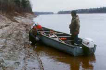
The following conditions will apply to motorboat use in the park:
- Little Missinaibi Lake Wilderness Zone - W1 (Map 1)
- Within the Quality Fisheries Zone. Road access, including tributary roads and trails, to Missinaibi Provincial Park are restricted under the Public Lands Act (sec. 26). Vehicle use of these roads / trails to access Missinaibi Provincial Park is prohibited (Sections 7.4, 8.2.2 & 9.3.3)
- No motorboats permitted, except by tourist outfitters and their clients in this zone (Section 7.4)
- The continued use of motorboats by commercial tourist outfitters in Little Missinaibi Lake Wilderness Zone will be assessed and reviewed
- Missinaibi River from Quittagene Rapids (NE1) to Camp 95 bridge (A6) on the Missinaibi River (Maps 1, 2 & 3)
- Motors not permitted from June 15 to August 31
- Missinaibi River from Thunder House Falls (W2) to Opasatika River (NE8) (Map 6)
- Motors not permitted from June 15 to August 31
- The area from Two Portage Falls in Rykert Township through to Sharp Rock Rapids in Staunton Township (Maps 3 & 4) will be monitored for potential use conflicts. Where problems arise, mutual solutions will be investigated and implemented as necessary.
Any changes to restrict motorboats or motor size will be regulated under the Provincial Parks Act and other relevant legislation.
Boat caches
Boat caches are not permitted unless authorized by the Park Superintendent. A program will be considered to manage boat caches in the park (Section 11.0).
9.2.2 Snowmobiles
Trappers with registered traplines may use snowmobiles to access their traplines.
Snowmobiles are permitted on trails authorized by the Park Superintendent in natural environment, access and development zones (see Map Section).
Trail crossings may be considered in natural environment, access and development zones, and will be subject to the amendment process, which involves public consultation.
Trail development in the vicinity of the park will be reviewed to ensure that the integrity of the park is not adversely affected.
Public input resulting from the Missinaibi Preliminary Park Management Plan (1994) indicated that the local snowmobile club expressed an interest in developing a snowmobile trail to Thunder House Falls (Sections 7.1-NE7-b & 7.4- W2). Some preliminary discussions with the club have occurred and routes discussed. Trail proposals in the park will be considered on a case-by-case basis and will receive public consultation and follow MNRs environmental assessment requirements and standards.
9.2.3 All-Terrain Vehicles (ATVs)
ATVs will not be permitted in Missinaibi Provincial Park with a few exceptions as noted below.
North of Mattice on both the east and west side of the Missinaibi River, ATVs will be permitted on the abandoned and deteriorating road system, which winds in and out of the park. These old roads may not be upgraded or used to create new access to the Missinaibi River. Use of ATVs in the winter will not be permitted except on designated trails. Trails occur north to Isabelle and Alice Islands on the east and west sides respectively. These trails are generally not visible from the Missinaibi River. Organized groups may be allowed to carry out activities such as trail brushing or maintaining existing water crossings of streams draining into the Missinaibi River, with the prior written approval from the Park Superintendent. Trail widening or lengthening is not permitted. Groups will be encouraged to relocate trails outside the park. These trails will not access the Missinaibi River outside of the identified access zones (Section 7.5).
ATVs have used existing and abandoned logging roads adjacent to the park to access the Missinaibi River at Glassy Falls and other locations south of Mattice. Previously owned private lands have been acquired south of Mattice, which will be regulated as part of Missinaibi Provincial Park (Section 7.1- NE6-b). This will allow for planned use and management of access (Section 7.5). Site planning will evaluate resource protection measures. Eroded sites will be rehabilitated.
Trails will be discontinued or rerouted to protect park related values.
Trappers will be permitted to use ATVs to work traplines within the park with prior written authorization from the Park Superintendent.
The use of ATVs in access zones (Section 7.5) only will be permitted where vehicular (i.e. cars & trucks) road access occurs. Access zones that do not provide access to cars and trucks will not provide access for ATVs.
9.3 Access to the park
Access to the park is intended to maintain opportunities for remote recreational experiences and protect park values.
Access to the park will be monitored and may require additional controls if increases occur that negatively impact sensitive natural or cultural values, create unnecessary conflicts with existing and traditional park users, or establish new uses that are not appropriate in a Canadian Heritage River.
Access zones are described in Section 7.5.
9.3.1 Air access
As per the Provincial Parks Act, all aircraft landing in the park will require prior authorization from the Park Superintendent through a valid aircraft landing permit from Ontario Parks.
Air access by commercial tourism operators will be permitted in natural environment and access zones, such as Missinaibi Lake (NE1), Brunswick Lake (NE5), Bells Bay (A10) and on the Missinaibi River downstream of the Thunder House Falls Wilderness Zone (W2), to access hunt camp LUPs in the fall (NE8) (Sections 7.1 & 7.5, see Map Section).
Air access by private operators will be permitted in Bells Bay (A10) (Section 9.2.1).
In addition to these locations, air access will be permitted by holders of LUPs, leases or patents for the purpose of accessing their properties on Missinaibi Lake, Little Missinaibi and Brunswick Lake. In Little Missinaibi Wilderness Zone (W1), commercial tourism operators will be permitted to land aircraft to access the site of their LUP. Aircraft landing in wilderness zones is a non-conforming use, however these LUPs pre-existed the addition of Little Missinaibi Lake to the park (1989). These LUPs will be permitted to continue, however will be reviewed in the future.
There is an existing airstrip located in the park adjacent to Brunswick Lake Lodge, authorized under a LUP. It is a non-conforming use within a natural environment zone, however it pre-existed the park and may continue to be used. If the LUP is cancelled this area will become part of the natural environment zone (Section 7.1-NE5).
9.3.2 Rail
The rail stop at Peterbell (Map 2, A2) provides access for canoe trippers travelling the upper Missinaibi River. Trips from this point most often end at Mattice. The rail stop at Moose River Crossing (Map 7) is used by canoeists travelling on the lower Missinaibi River from Mattice which cuts off the two extra days required to reach Moosonee.
The railways crossing the Missinaibi River are important transportation routes for canoe trips. Rail connections can sometimes be made back to the point of origin, and the train provides a route south from Moose River Crossing and Moosonee.
Ontario Parks will explore partnership opportunities to provide rail access for canoeists travelling both sections of the Missinaibi River (Section 11.0).
Prior to any work that may impact the adjacent railway right-of-way Ontario Parks will contact the railway company (Section 11.0). Ontario Parks should be consulted regarding any proposed work within the railway right-of-way that may result in impacts on the park.
9.3.3 Road access
Public roads lead to Barclay Bay Campground and the Municipality of Mattice-Val Côté (Maps 1 & 4).
Resource access roads adjacent to the park are developed and maintained for resource extraction purposes, and are abandoned once the intended use is completed in an area. In some instances, roads are re-opened to continue work, or to access other locations. Plans for the development, use and abandonment of all resource access roads on Crown land are documented for public review in the form of use management strategies. These use management strategies for roads adjacent to Missinaibi Provincial Park and proposals for upgrading abandoned roads for recreational use should be guided by the following:
- Existing and abandoned resource access roads adjacent to the park boundary that are used to access the Missinaibi River outside of access zones as depicted in this park management plan are unauthorized access
- Proposals for new resource access roads should be evaluated to assess potential impacts on park values. MNRs environmental assessment requirements will be considered and met for all proposals. Guiding criteria to aid this evaluation are presented in Appendix I, also see Section 9.4
Vehicle access via abandoned roads to Brunswick Lake and Brunswick River is permitted in accordance with the conditions described below, as long as any associated culverts or water crossing structures are in a functional and safe condition and meet MNRs standards. All trails and other old roads to Brunswick Lake and River should be closed and rehabilitated.
The maintenance/upgrade/closure/rehabilitation of all roads within the park are subject to MNRs policies, procedures, standards and environmental assessment requirements. Prior to any road work the Park Superintendent must be consulted. Should any road within the park be abandoned it may be closed and rehabilitated.
The use of Brutus Road, Woods Lake / Chaplin / Clifton Main Road, including all tributary roads and trails, to gain access to Missinaibi Provincial Park are prohibited under the Public Lands Act (sec. 26). Vehicle use of these roads / trails to access Missinaibi Provincial Park is prohibited (Sections 7.4 & 8.2.2).
Conditions
Access zones (Section 7.5), that are dependent upon the condition of abandoned resource access roads, may be maintained in partnership with groups and individuals. If these locations are not adequately maintained, Ontario Parks retains the option to close them to public access. Site plans will be prepared in cooperation with interested individuals and groups to indicate the standards, rehabilitation and minor site improvements to sustain environmental conditions and aesthetic qualities. Such improvements will not result in an increased capacity at these sites. Sites large enough to permit parking for day-use in the park, for example, will not be improved to a condition or size such that camping could occur. Any increases in road use caused by road maintenance will be controlled to maintain current levels and type of use.
Redevelopment of abandoned roads will be managed so that direct or indirect access to Missinaibi Provincial Park will not be permitted except at designated access zones (Section 7.5). Partnership arrangements are discussed in Section 9.7.2 and Appendix II.
Currently all access to Missinaibi Provincial Park via the resource access roads in the vicinity of Little Missinaibi Lake is restricted
9.3.4 Water access
Numerous creeks and rivers running into the park’s lakes and rivers have the potential to provide access. Planning for resource access roads in forest management plans will aim to restrict or minimize access to the park.
The Ministry of Natural Resources will use the criteria noted in Appendix I to evaluate the potential impact that new roads adjacent to the park may have on park values. This will aid in determining the location of a road in relation to water systems, and how access will be managed.
9.4 River crossings
9.4.1 Bridges and winter crossings
The Missinaibi and Brunswick River bridges in Abbott Township, also known as the Camp 95 bridges, will continue to be used for forest management purposes, for the foreseeable future (Map 3). See Section 9.3.3 concerning recreational use of these bridges
No consideration will be given to the establishment of new bridges at Quittagene Rapids, Barrel Rapids or Fire River. The existing crossings in Abbott Township will permit the continued transport of wood and equipment from either side of the Missinaibi River to work sites and mills without the environmental impact associated with the construction of new bridges on the Missinaibi River.
Use of abandoned crossings in Scovil Township (Maps 5 & 6), McBrien Township (Map 6) and Hambly Township (Map 6) may be considered in the future as winter crossings for snowmobiles only through an appropriate planning process (Provincial Parks Council Recommendations and Minister’s Responses, 1994).
In Scovil Township, a winter crossing may be permitted for use as a snowmobile crossing only. This winter crossing may allow snowmobile access to the park boundary near Thunder House Falls described in Section 9.2.2.
In McBrien and Hambly Townships, a potential winter crossing for future mineral exploration outside the park will be precisely located following on-the-ground site inspections. Park values will be considered to ensure protection.
Any future corridors (e.g. roads) proposed through the park will be reviewed on a case-by-case basis. Protection of park values (natural, cultural, remote recreational) will be a priority and MNRs environmental assessment requirements must be met.
9.4.2 Utility corridors
Ontario Parks and the Ministry of Natural Resources will work with Hydro One to establish site specific management practices to mitigate any possible adverse effects related to transmission corridors. Any work on the Trans Canada Pipelines natural gas pipeline, which presently crosses on the Missinaibi River bottom in the development zone at Mattice, will be closely monitored (Section 11.0).
Any future utility corridors (e.g. gas, water, hydro) proposed through the park will be reviewed on a case-by-case basis. Protection of park values (natural, cultural, remote recreational) will be a priority and MNRs environmental assessment requirements must be met.
9.4.3 River crossings - approval process
Future proposals for new or the expansion of existing crossings
Specific guidelines for site planning standards and rehabilitation of new and existing crossings will be developed through the site planning process and will be the responsibility of the proponent.
All previously abandoned crossings will be rehabilitated as much as is feasible given the logistical problems, which may be encountered when returning to a site with appropriate equipment.
9.5 Commercial tourism
Existing commercial tourism services will continue in Missinaibi Provincial Park (Section 10.4). Tourism agreements between Ontario Parks and operators will establish guidelines for businesses using the park.
Guided and outfitted canoe trips will be encouraged. Organizers will adhere to this park management plan and existing provincial park policy for permits, access, travel and camping in the park.
9.6 Natural heritage education
Strategies for the park’s natural heritage education program will:
- provide detailed, up-to-date river route information
- foster appreciation for the natural, cultural and recreational values of this waterway both as a provincial park and as a Canadian Heritage River; and
- provide information about local attractions and services
A natural heritage education plan will be prepared. Specific program direction, which may include educational initiatives designed to enhance awareness of, and involvement in, the park by area schools and other interests (e.g. naturalist clubs, youth groups) will be identified. The park’s level of service will be "self-use" as defined in provincial park policy (Sections 8.3 & 11.0).
Interpretive opportunities may be developed to enhance the delivery of the information, interpretation and recreation components noted below (Section 10.3).
9.6.1 Information
Public information services using print, electronic, display media, and personal contact will be aimed at the broad range of users. Orientation kiosks and information/visitor centres may be established in partnership with other interests in the park.
Human use of the Missinaibi-Michipicoten River travel route connected Lake Superior and James Bay and dates back at least 2,000 years. Historic contact between Aboriginal people, and English and French explorers and fur traders represents the first period of intense use of the route. This was followed by significant change when the primary economic uses of the region shifted away from the Missinaibi River with the development of east-west railroads and highways. Timber and mining industries and related settlement occur east and west of the Missinaibi River. Trapping and canoe travel are the most constant activities associated with the Missinaibi River having ancient to present day travel and use of the Missinaibi River. Most recently, recreational users have come to appreciate the natural beauty and the range of outdoor uses of the waterway.
Other themes will focus on the park’s natural features, and the philosophy, ethics and management of safe waterway travel.
Opportunities to learn and gain an appreciation of the character and significance of Missinaibi Provincial Park will be presented in printed material, self-use facilities and displays, and informal personal contact through park staff. This self-use level of service may be complemented by the development of interpretation facilities (Section 10.3).
In an effort to enhance community awareness and appreciation for the park, special presentations and events may be held in local communities. Initiatives with local media will be encouraged.
9.6.2 Recreation
As opportunities and needs arise, recreational skills programs, such as canoeing and wilderness travel, may be offered as special events to help visitors understand and better enjoy the many aspects of the park.
Information services will focus on:
- trip planning (e.g. map reading, seasonal water levels and travel skills required, transportation logistics, local services and attractions)
- park management messages (e.g. safe travel, minimum impact camping including dealing with garbage, human waste, potential for wildlife contact such as with black bears, common offenses, and the necessity of sustaining the park’s natural and cultural heritage, etc.); and
- the values, extent and permitted uses in the Chapleau Crown Game Preserve within and beyond the park
9.6.3 Interpretation
Relaying information about park resources will be the focus of interpretation. This will emphasize the historical importance of this free flowing waterway. The major interpretation theme for Missinaibi Provincial Park will be "peoples' reliance on a mighty river".
9.7 Research and partnerships
As part of the Ministry of Natural Resources' responsibilities under the Canadian Heritage Rivers System (CHRS) and its related guidelines, activities which may affect the river values will be monitored. The parameters chosen for monitoring will relate to maintaining the integrity of the park. Ontario Parks will report any changes in the condition of the river and values for which it was designated, to the CHRS Board through the annual CHRS report and every ten years a "State-of-the-River" Report will be submitted to the Board (Section 11.0).
9.7.1 Research and inventory
Scientific research by qualified individuals and institutions that will be compatible with the park’s protection objective and contributes to the knowledge of natural and cultural history and to environmental and recreational management, will be encouraged in the park. All research programs will require the approval of Ontario Parks and will be subject to provincial parks policy and applicable legislation.
Additional earth and life science inventory work, aquatic and terrestrial ecosystem monitoring, and recreation use studies will provide a more thorough understanding of park values and uses.
Priorities will be developed for inventory, assessment and monitoring of park resources in conjunction with MNR districts, partners, and described in implementation plans noted in previous sections of this management plan. If deemed appropriate, a monitoring plan may be considered, as a means to consolidate and coordinate needs.
The Missinaibi River will be assessed for its potential to provide benchmarks for future research conducted by government and non-government interests. Data and products generated will be used to assess a range of impacts that may affect Missinaibi Provincial Park’s aquatic ecosystems and other similar rivers.
9.7.2 Volunteers and friends
Individuals and organizations will be encouraged to volunteer time and services in the management of Missinaibi Provincial Park. Assistance may be sought through partnerships to aid in such areas as environmental cleanup, and to enhance natural heritage education programming.
In close consultation with area residents and groups, Ontario Parks will investigate whether there is an interest in a non-profit cooperating association.
9.8 Marketing
Visitors to Missinaibi Provincial Park include local residents, and persons from many parts of Ontario, Canada, North America and the world. People learn about the park through Ontario Parks' publications and website, by word of mouth and through various other means including internet sites that promote adventure travel.
A review of park attractions, management issues and marketing methods will be conducted to determine how to raise the awareness of park values and to increase the safety of visitors and awareness of the "leave no trace" ethic for river travel. This will form the basis of a marketing plan for the park.
This park management plan was submitted as the final requirement for Missinaibi Provincial Park to be designated as a Canadian Heritage River
Care will be taken to ensure that marketing initiatives do not create over use of the park and thus spoil its wilderness appeal or affect natural and cultural values. Measures presented in Section 9.1 will aid in monitoring such concerns.
10.0 Development policies
This section presents the development for the park. Approved site plans and implementation planning will be completed for development projects. MNRs environmental assessment requirements, which may require further public consultation, will be met prior to project implementation.
10.1 Backcountry facilities
Where a need is identified through the recreational resources inventory (Section 9.1), primitive facilities, such as privies and additional campsites may be developed. Campsite rehabilitation will be carried out where necessary (Section 11.0).
Some areas of the park receive intensive use. To protect these areas from litter and soil erosion Ontario Parks will work to establish conservation agreements with the principal recreational users (Appendix II). Also see Sections 7.5, 9.1, 9.2 and 9.3 for policies related to this issue.
10.2 Barclay Bay Campground
Park visitors to the Barclay Bay Campground have traditionally preferred minimum facilities in a remote setting. Many visitors come self-contained and stay an average of four nights (Section 7.6-D1). Existing development includes campground, vault privies, dock and boat launch, fish cleaning building, maintenance facilities and gatehouse. A campground development plan will be prepared and will include proposed development for the Barclay Bay Campground illustrated on Map 8. Site planning will determine the location of new facilities within the development zone, as outlined below.
In the short-term, priorities for new development in this zone include waterfront re-development (e.g. docking, boat launching, fish cleaning area, information kiosk etc.), trailer dumping station and additional parking facilities. Long-term needs include additional vault privies and campsites, mini-comfort station and possibly roofed accommodations.
Additional services may be provided in the campground area if a need is identified in the future. Provision of basic commodities such as ice, camping supplies, gasoline, canoe rentals, etc. will be considered if demand warrants.
10.3 Interpretation facilities
Interpretation facilities (e.g. interpretive signs, displays, etc.) may be constructed in partnership with interests at strategic locations along the Missinaibi River. Possible partners are the Municipality of Mattice-Val Côté, the Township of Chapleau, the Municipality of Moose River Crossing and First Nations.
- Interpretive opportunities at Highway 11, may be developed in cooperation with the Municipality of Mattice-Val Côté. This would complement the municipality’s interest in recognizing the history of Missinaibi River travel including: centuries old Aboriginal trade and travel; routes connecting the Missinaibi River to other waterways south and north; as well as some 200 years of fur trade including the historic Fort Wapiscogamy. This would also promote park objectives
- Wildlife heritage interpretation, located within or nearby the Town of Chapleau, may be considered. This interpretive opportunity could provide a regional tourism focus on the wildlife and habitats of the Chapleau Crown Game Preserve and Missinaibi Provincial Park
Each of these locations serves largely discreet clientele with different emphasis and as such merit consideration. An interpretive facility located at Barclay Bay Campground will not be considered.
Image of the Hiking – Whitefish Falls on the Little Missinaibi River
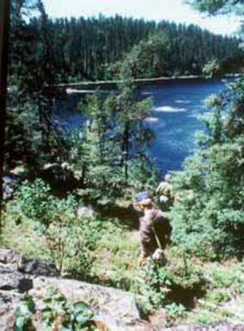
10.4 Commercial tourism
A tourism plan will examine the existing tourism infrastructure and supply of services within and adjacent to the park. It will also evaluate the potential for new services within and adjacent to the park that could benefit local economies as well as the Province and that do not negatively impact on park values.
Business planning relating to tourism will be consistent with park objectives and provincial park policy and with the following directions that are the result of public input obtained in the preparation of this park management plan.
- New recreation and tourist services for the park will be reviewed on a case by case basis. Visitors will be encouraged to use existing tourist services in the park and in local communities, and to visit local attractions
- Canoe travel and camping have the longest tradition of human use in the park. This is particularly evident in the Thunder House Falls area. Uses adjacent to the park, such as winter travel to the Thunder House Falls area, will be carefully planned in order to retain and even augment wilderness and aesthetic values
- Any proposal must meet "protection" and "unnecessary conflict" crit Protection of the environment is key to park objectives as well as the Canadian Heritage Rivers designation. When determining the appropriateness of recreation and tourism services throughout the entire park, evaluations will assess the cumulative impacts of all proposals on park values
Also see Section 9.5 for policies regarding existing commercial tourism operations.
11.0 Implementation priorities
This section presents a summary of the priorities and policies to be implemented with this park management plan. Projects listed here, or resulting from the preparation of subsequent implementation plans, will be undertaken in accordance with due regard for the Ministry’s environmental assessment obligations, which may require further public consultation.
Implementation is not restricted to the following order:
Park boundary
- Complete boundary amendments as per the direction in this park management plan (Section 6.0 & 7.0-NE4-b, NE5-b, NE6-b, NE8-b, H4-b, NR4-b, NR7-b, NR8-b, NR9-b). This would include regulating the lands in Habel, McBrien, Rykert, Orkney, Magladery and Staunton Townships (Section 6.0 & 7.0).
Further evaluate and rationalize the park boundary to ascertain the natural and cultural feature limits for the values that form the basis of the park. Having completed the above evaluation, establish strategies for their protection (e.g. provide input to future land use planning processes), and seek conservation agreements where necessary (Sections 6.0 & 7.0).
Resource stewardship
- Work with Fish & Game clubs or other interested parties to identify, develop and maintain access at North Brunswick River (Section 7.5, A5)
- Prepare park values map to participate in forest management planning, other resource management planning and other development proposals (Section 8.1.1)
- Prepare a vegetation stewardship plan (Section 8.1.2).
- Close all existing aggregate pits in the park and develop an aggregate resources rehabilitation plan (Section 8.1.3)
-
Notify private recreation camp LUP holders of phase out (Section 8.1.6)
Prepare notice of phase out of LUPs for private recreation camps, to be released to LUP holders in the summer prior to the January 1, 2010 phase out (Section 8.1.6)
- Prepare a wildlife stewardship plan (Section 8.1.9)
- Prepare notice of phase out of commercial fur harvesting in wilderness and nature reserve zones, to be released in the summer prior to the January 1, 2010 phase out (Section 8.1.9)
-
Coordinate river wide aquatic ecosystem data collection (Section 8.2)
Assess Missinaibi Lake and related aquatic ecosystems (lakes, wetlands, riverine)
- Prepare notice of phase out of commercial bait harvesting in wilderness and nature reserve zones, to be released in the summer prior to the January 1, 2010 phase out (Section 8.2.2)
- Prepare a fire management plan (Section 8.5.1)
- Prepare recreation resources inventory (Section 9.1 & 10.1)
- Close and rehabilitate all trails and other abandoned roads to Brunswick Lake and River that are not authorized (Section 9.3.3)
- Carry out additional earth and life science inventories, aquatic and terrestrial ecosystem monitoring and recreation use studies to provide a more thorough understanding of park values and uses (Section 9.7.1)
- Establish partnerships to assist in environmental clean-up and natural heritage education programming (Section 9.7.2)
Operations
- Amend policy reports and mapping of the CLUPA to reflect the direction of this park management plan (Section 8.0)
- Review commercial tourism LUPs (Section 8.1.4).
- Amend the regulation under the Fish and Wildlife Conservation Act (Section 8.1.9).
- Seek to reacquire artifacts removed from the park (Section 8.3)
- Prepare a cultural resources stewardship strategy involving local First Nations (Section 8.3)
-
Prepare a park operating plan including a review of operating and non-operating areas of the park (Section 9.0)
Maintain operating portion of the park to minimum provincial standards. Carry out enforcement/compliance monitoring for the park (Section 9.0).
-
Monitor litter and establish ban on non-burnable and beverage containers if necessary (Section 9.1.2).
Consider partnerships to increase public awareness (Section 9.1.2)
-
Monitor motorboat use and develop solutions if necessary (Section 9.2.1)
Regulate motor use under the Provincial Parks Act and other relevant legislation as per section 9.2.1 (Section 9.2.1)
- Consider development of a program to manage boat caches in the park (Section 9.2.1)
- Monitor access to the park and establish controls if necessary (Section 9.3)
- Work with local snowmobile and ATV clubs Establish appropriate partnerships/ agreements (Sections 9.2.2 & 9.2.3)
-
Explore partnership opportunities to provide rail access (Section 9.3.2)
Prior to any work adjacent to the railway right-of-way Ontario Parks will contact the railway company (Section 9.3.2)
- Work with Hydro One to establish site specific management practices related to transmission corridors (Section 9.4.2)
- Monitor any work on the Trans Canada Pipeline (Section 9.4.2)
- Establish tourism agreements with tourist operators (Section 9.5)
- Prepare a natural heritage education plan (Section 9.6)
- Consider partnerships to establish kiosks & information/visitor centres (Section 9.6.1)
- Report any changes in the condition of the river and values for which the river was designated to the CHRS Board through the annual CHRS report and the ten year "State of the River" report (Section 9.7)
- Assess research linkages and implement where applicable (Section 9.7.1)
- Investigate potential for a cooperating association (Section 9.7.2)
- Prepare a marketing plan (Section 9.8).
- Prepare a tourism plan (Section 10.4).
Development
- Assess management needs at Glassy Falls and prepare site plans for rehabilitation (Section 7.5, A7)
- Establish backcountry facilities (Section 9.1)
- Assess the potential for hiking trails. Prepare implementation plans for trail development (Section 9.1.1)
-
Develop backcountry facilities as identified in recreation resources inventory (Sections 9.1 & 10.1).
Rehabilitate campsites where necessary (Section 10.1)
- Prepare a campground development plan for Barclay Bay Campground (Section 10.2)
- Develop trailer dumping station and additional parking facilities at Barclay Bay Campground (Section 10.2)
- Develop additional campsites, privies and mini-comfort station at Barclay Bay Campground, as required (Section 10.2)
- Consider basic commodities (e.g. ice, camping supplies, gasoline, canoe and kayak rentals, boat and motor rentals) if demand warrants (Section 10.2)
- Implement waterfront re-development (e.g. docking, boat launching, fish cleaning area, information kiosk etc.) at Barclay Bay Campground (Section 10.2)
- Consider partnerships to develop interpretive facilities (Section 10.3)
12.0 Social and economic impact analysis
Missinaibi is an important part of the region’s tourism infrastructure.
As the Missinaibi park management plan is implemented, there will be certain social and economic impacts. A social and economic impact analysis will be completed as part of future reviews. It will be completed in conjunction with other affected ministries and may involve other levels of government and private sector interests.
Job creation and income generation may occur from the provision of tourism services based on the use of Missinaibi Provincial Park. Services include: Barclay Bay Campground, river canoeing and the development of the variety of services for visitors as presented in this park management plan and subsequent implementation plans.
Provincial parks and protected areas, such as conservation reserves, provide a wide range of benefits. Some of the benefits can be measured in economic terms other benefits cannot. Traditionally, parks and protected areas have reported on the economic impacts associated with park and visitor expenditures.
Economic impact is a way to track and demonstrate the flow of park and visitor expenditures in the economy. The following are economic impacts associated with park expenditures and the estimated visitor spending at Missinaibi Provincial Park for fiscal 2000/2001.
The estimated total initial expenditure at Missinaibi Provincial Park during fiscal 2000/2001 was $332,610. A total of $119,308 was spent on park operations. Capital expenditures amounted to $71,200. Camper and day visitor expenditures on food and beverages, fuel and transportation, attractions and entertainment and miscellaneous totaled $142,102.
Ontario Parks reports on the following indicators of economic impact (Appendix III):
- Value Added
- Provincial Gross Sales (or Provincial Gross Output)
- Wages & Salaries
- Person Years of Employment
As noted previously, economic impacts are based on expenditures. The expenditures made by the park on operations and capital as well as average visitor trip expenditures (camper and day visitor) compose the initial expenditure. The visitor expenditures were taken from the 1998 Day Visitor and Camper Surveys for Missinaibi. Park operating and capital expenditures were taken from the unit cost analysis sheets. The above noted information is entered into an input-output model licensed to MNR for economic analysis.
Based on an initial expenditure of $332,610 the following impacts were sustained at Missinaibi in 2000/2001 (the figures are for the total economic effects [direct + indirect + induced effects]):
- Value Added (a conservative and more accepted measure of impact) - $452,282
- Provincial Gross Sales (or Provincial Gross Output)- $810,546 (the problem with this figure is that it double counts)
- Wages & Salaries - $311,311
- Person Years of Employment – 8.2
There are other benefits which provincial parks and protected areas provide to local communities, the province and society in general. A number of important benefits are listed below. These benefits demonstrate how parks and protected areas support our quality of life:
- protection and contribution to ecological functions (water & soil production)
- protection of resource integrity (some of the last green spaces left in the province)
- health effects from use of parks (mental, physical, spiritual benefits)
- worker productivity (healthy and happy workers tend to be more productive - a visit to a provincial park can contribute)
- educational benefits (young and old learning about our environment)
- scientific benefits (research in provincial parks)
- international responsibilities to protect natural settings, features and wildlife
- business location decisions (quality of life/business) and community cohesion
Provincial parks and protected areas help to make communities attractive for businesses as well as for tourists and retirees. The retirement community brings in pension income, which is often indexed to inflation and is recession proof. Communities with attractive waterfronts, low crime, recreational activities and healthy environments are sought out by tourists, the retirement community and businesses.
One of the most often sought after and tangible measures of the social and economic contribution of a protected area is the number of jobs supported. The combined economic activity at Missinaibi supports 8.2 person years of employment in the province each year. Park related spending provides the area with employment opportunities and contributes to a stable local economy and community.
13.0 Summary of public consultation
The planning process for Missinaibi Provincial Park began in 1986 with the release of a background information tabloid inviting public comment. This publication encouraged individuals and groups to come forward with knowledge and opinions concerning the park, in order to allow the Ministry to provide more accurate information during subsequent stages of the planning program. In November of 1988 the Missinaibi planning project was resumed with the release of a newsletter, following the resolution of permitted uses in Ontario Provincial Parks announced in May of 1988. The bilingual Tabloid #2 was sent to participants in 1989, summarizing public input that had been received by the Ministry of Natural Resources.
A bilingual document titled "Proposed Zoning and Policy Options" was reviewed by the public from April to June 1990. Approximately 365 copies were sent to individuals and groups on a mailing list. An estimated 375 additional copies were distributed at public meetings and through follow-up inquiries. The purpose of this document was to solicit public input for the subsequent development of the Missinaibi Preliminary Park Management Plan (1994).
Between April 23, 1990 and May 4, 1990 Ministry staff presented an overview slide show of the "Proposed Zoning and Policy Options" document to 22 groups to aid their understanding of the details in preparation for review by the Provincial Parks Council, a citizen’s advisory committee.
The Provincial Parks Council held five public meetings between May 8 and May 16, 1990, in the communities of Mattice, Kapuskasing, Moosonee, Chapleau and Toronto. Approximately 425 people attended these sessions.
Participants were asked to complete a questionnaire (in English or French) consisting of 50 questions with ample room provided for additional comments. In total, 494 questionnaires and numerous written briefs were returned. Written public input came in three main ways: letters, briefs and questionnaires. The Ontario Provincial Parks Council reviewed this input. In November 1990 the Council submitted 105 recommendations on the management of Missinaibi Provincial Park to the Minister of Natural Resources.
Additional information was sent to participants regarding forest management planning activities in areas adjacent to Missinaibi Provincial Park (e.g. the Gordon Cosens Forest, Superior Forest). Additional meetings were held with interest groups to discuss how forest management prescriptions could help to ensure the protection of park values.
The Parks Council’s recommendations and corresponding Minister’s responses formed the basis of the Missinaibi Provincial Park Preliminary Management Plan (1994).
The Minister’s responses and the Missinaibi Provincial Park Preliminary Management Plan were released in May 1994. Public meetings were held in 1994 in Kapuskasing, Mattice, Chapleau, Moosonee and Toronto to present the proposed policies for protecting and managing park resources. Subsequent meetings were held in Hearst, Kapuskasing and Mattice as well as field trips to Brunswick Lake and Thunder House Falls in 1996 to refine proposals.
Public input came from 44 groups and/or individuals. This input was used to further develop the park management plan.
Ontario initiated a significant land use planning and public consultation process between 1997 and 1999 called Lands for Life. Development of the final park management plan for Missinaibi was put on hold. New parks and protected areas were identified, including three additions to Missinaibi Provincial Park, P1542, P1543 and P1544. The 1994 preliminary park management plan was revised and released as a preliminary plan in March 2002 to reflect the results of the Lands for Life planning process, Ontario’s Living Legacy Land Use Strategy (1999) and to meet MNRs requirements under the Environmental Bill of Rights.
Ontario’s Living Legacy Land Use Strategy (1999) identified three additions to Missinaibi Provincial Park. Boundary consultation began for new parks and protected areas, including the additions to Missinaibi, after the public release of the Land Use Strategy in 1999. The public was invited to comment on the Missinaibi-Hay River Addition (P1542) between September 6 – October 6, 2000. One comment was received.
The public was also invited to comment on the Missinaibi-East (P1543) and the Missinaibi-Thunder House Falls (P1544) Additions between September 16 - October 16, 2002. Three comments regarding P1543 were received, zero on P1544.
The Missinaibi-Hay River Addition was regulated on June 7, 2003 under the Provincial Parks Act, as Ontario Regulation 210/03 with an area of 2,308 hectares.
The Missinaibi Preliminary Park Management Plan (revised) was approved by Ontario Parks on February 27, 2003 and released for public inspection on March 31 – May 26, 2003. A total of thirty-four responses were received during the consultation period, six of those were received after May 26th. Most comments were supportive regarding the direction of the plan, however specific concerns were expressed regarding access to Brunswick Lake and the use of motor boats in the park.
All comments received throughout the planning process were considered during the completion of this park management plan.
The public will continue to have direct involvement in the management of Missinaibi Provincial Park through the subsidiary implementation plans as described herein.
The methods of consultation utilized during the planning process were:
Mailing lists
- Mandatory Mailing List – as per Provincial Park Policy (PM 11.02.02)
- Adjacent property owners (as per Exemption Order 59/2)
- First Nations communities and organizations
- Commercial fur harvester, commercial bait fish harvesters and adjacent bear management area operators
- Commercial tourism operators, recreation clubs/organizations and land use permit holders
- Mailing list of local residents and businesses
- Individuals who requested to be put on the mailing list; and
Newspaper notices
Newspaper notices in the following newspapers:
- English Language: Toronto Star, Chapleau Express, The Northern Times (Kapuskasing), The Bear News (Hornepayne), Algoma News Review (Wawa), The Daily Press (Timmins), The Cochrane Times
- French Language: Hearst Le Nord
Environmental Bill of Rights (EBR) registry:
EBR proposal notice posted on March 31- May 26, 2003 inviting public to participate.
EBR decision notice posted for the approved plan.
Ontario government:
During public consultation the preliminary park management plan (revised) was available at the Ontario Parks Northeast Zone office, the Chapleau, Hearst, Kapuskasing, Moosonee MNR District offices and the Natural Resources Information Centres in Toronto and Peterborough.
The Preliminary Park Management Plan (2003 revised) was available on the Ontario Parks website during the public inspection period and the approved plan is available on the Ontario Parks website (www.ontarioparks.com).
14.0 Selected references
Biggar, C., 1992. A Biological Inventory and Evaluation of Hay River Wetlands Area of Natural and Scientific Interest. Ontario Ministry of Natural Resources, Northeast Region. Bird and Hale Ltd.
Canadian Heritage Rivers System. n-d. Nomination Document for the Missinaibi River, Ontario.
Department of Energy, Mines and Resources, 1973. Quaternary Stratigraphy of the Moose River Basin, Ontario. R.G. Skinner, Geological Survey of Canada, Bulletin 225.
Dewdney, S. & Kidd, K., 1962. Indian Rock Paintings of the Great Lakes. University of Toronto Press.
Forest Values, Sustainable Forestry, Social Economic Impact Model, Technical Manual, OMNR 1995.
Guillet, G.R., 1985. Industrial Mineral Resources of the North Clay Belt. Northeast Municipal Advisory Committee and the North Clay Belt Development Association.
Noel, L. editor., 1995. Voyages, Canada’s Heritage Rivers. Atlantic Centre for the Environment.
Ontario Government, 1989. Provincial Parks Act. Revised Statutes of Ontario,.
Ontario Government, 1980. Provincial Parks Regulations. Revised Regulations of Ontario.
Ontario Ministry of Culture and Recreation and Ontario Ministry of Natural Resources, 1976. Wapiscogamy Hudson Bay Company Post, Missinaibi River an Archeological Inspection and Assessment (1779 - 1806). John W. Pollock.
Ontario Ministry of Culture and Recreation, n.d. The Fur Trade in the Moose-Missinaibi River Valley 1770-1917. Doug Baldwin, Research Report 8.
Ontario Ministry of Natural Resources, 2003. Crown Land Use Atlas.
Ontario Ministry of Natural Resources, 2003. Missinaibi Preliminary Park Management Plan (revised). Queen’s Printer for Ontario.
Ontario Ministry of Natural Resources, 1999. Ontario’s Living Legacy: Land Use Strategy. Queen’s Printer for Ontario. Ontario, Canada.
Ontario Ministry of Natural Resources, 1998. Ontario Park Business Plan.
Ontario Ministry of Natural Resources, 1996. Ontario Parks Business Plan.
Ontario Ministry of Natural Resources, 1994. Ontario Provincial Park Management Planning Manual.
Ontario Ministry of Natural Resources, 1994. Missinaibi Provincial Park Proposed Zoning and Policy Options: Recommendations by the Provincial Parks Council and Minister’s Responses.
Ontario Ministry of Natural Resources, 1994. Missinaibi Provincial Park Preliminary Management Plan.
Ontario Ministry of Natural Resources, 1993. Interim Strategy for Biodiversity Considerations in Timber Management Planning. George Duckworth and Mark Fleming.
Ontario Ministry of Natural Resources, 1992. A Biological Inventory and Evaluation of Hay River Wetlands Area of Natural and Scientific Interest. Prepared by Bird and Hale Ltd.
Ontario Ministry of Natural Resources and Hearst Forest Management Inc., 1992. Hearst Forest Draft Timber Management Plan.
Ontario Ministry of Natural Resources and Superior Forest Management Inc., 1992. Superior Forest Timber Management Plan.
Ontario Ministry of Natural Resources, 1992 (update '98). Ontario Provincial Parks Planning and Management Policies.
Ontario Ministry of Natural Resources and Spruce Falls Power and Paper Company, 1991. Gordon Cosens Forest Timber Management Plan.
Ontario Ministry of Natural Resources, 1990. Summary of Questionnaires from the Planning Document "Missinaibi Provincial Park-Proposed Zoning and Policy Options".
Ontario Ministry of Natural Resources, 1990. Missinaibi Provincial Park-Proposed Zoning and Policy Options. Public Consultation Document and Questionnaire.
Ontario Ministry of Natural Resources, 1990. The Chapleau Crown Game Preserve, Wildlife Management Plan.
Ontario Ministry of Natural Resources, 1990. Provincial Parks Policy Implementation. Fact Sheet, March.
Ontario Ministry of Natural Resources, 1989. Missinaibi Provincial Park Tabloid 2. Summary of Public Input.
Ontario Ministry of Natural Resources, 1989. Missinaibi Provincial Park: January 1989 Interest Group Meeting Notes. Anthony Usher Planning Consultant.
Ontario Ministry of Natural Resources, 1986. Missinaibi Provincial Park Background Information. Public Consultation Tabloid.
Ontario Ministry of Natural Resources, 1985. The 20th Century Human History of Missinaibi Provincial Park. Mary-Lynn Murphy and Kristen Franklin.
Ontario Ministry of Natural Resources, 1984. The Chapleau Crown Game Preserve, Wildlife Management Plan 1985-2000, Background Information.
Ontario Ministry of Natural Resources, 1982. A Reconnaissance Life Science Inventory of Missinaibi Lake Provincial Park,Sudbury/Algoma Districts, Ontario. Daniel Brunton Consultant.
Ontario Ministry of Natural Resources, 1982. An Assessment of Earth Science Processes and Features for Land Use Planning of Missinaibi Lake Provincial Park and Park Reserve. McKenzie McCulloch Associates.
Ontario Ministry of Natural Resources, 1982. Mesozoic Geology and Mineral Potential of the Moose River Basin. P.G. Telford and H.M. Verma, Ontario Geologic Survey, Study 21.
Ontario Ministry of Natural Resources, 1979. Candidate Earth Science and Nature Reserves, Chapleau District.
Ontario Ministry of Natural Resources, 1979. Missinaibi River Interim Management Plan.
Ontario Ministry of Natural Resources, 1977. Missinaibi River Park Reserve A Study. Ontario Ministry of Natural Resources, 1977. Information Missinaibi River. Public Consultation Summary.
Ontario Ministry of Natural Resources, 1977. Life Science Inventory Missinaibi River Park Reserve. Gary Shea.
Ontario Ministry of Natural Resources, 1976. Archeological Features on the Missinaibi River and Brunswick Lake. Dave Arthurs.
Ontario Ministry of Natural Resources, 1977. Fur Trade Sites on the Missinaibi River: A Preliminary Report on the 1976 Missinaibi River Archaeological Survey. Dave Arthurs.
Ontario Ministry of Natural Resources, 1976. Earth Science Inventory Missinaibi River Park Reserve. Ed Frey.
Ontario Ministry of Natural Resources and Environment Canada, n.d. The Missinaibi River, Ontario. Canadian Heritage Rivers System.
Ontario Provincial Parks Council, 1990. Missinaibi Provincial Park-Proposed Zoning and Policy Options Provincial Parks Council Recommendations.
Parks Canada, Canadian Heritage Rivers System.
Township of Mattice-Val Côté, 1992. Proposal for Reconstruction of Fort Wapiscogamy. Michel LePage.
Township of Mattice-Val Côté, 1991. Tourism Development Study, Missinaibi River.
Wilson, H. 1994. Missinaibi-Journey to the Northern Sky from Lake Superior to James Bay by Canoe.
Appendices
Appendix I
Evaluating the potential impact of resource access roads on park values
Introduction
The potential for unplanned access to the park arises from the creation of new roads or upgrading of existing roads or near navigable waterways that connect with the park. New access roads are developed mainly by logging companies as they harvest in new areas. They are used during the harvesting period and during forest renewal and maintenance. Once new forests are established, these roads are normally abandoned for industrial purposes, but continue to be used for recreational purposes.
When roads are located too close to the park or associated navigable waterways the potential for unplanned access increases. The intent is to provide an appropriate level of access to the park to support varying recreational opportunities while preserving its wilderness appeal (Appendix II).
Policy statements
"All season (graveled) roads should be located with the intention of preventing unplanned access to the park while retaining flexibility for forest operations. Minimum distances for roads from the park boundary should be considered in forest management plans. Road locations should be carefully reviewed by Ministry of Natural Resources staff (including Ontario Parks staff)" (Section 8.1.1).
"Proposals for new resource access roads should be evaluated to assess potential impacts on park values" (Section 9.3.3).
Criteria to evaluate proposals for new resource access roads
The Ministry of Natural Resources documents plans for the development, use and abandonment of all resource access roads on Crown land in the form of "Use Management Strategies". These strategies are developed with public input.
Resource access roads in the vicinity of the park should:
- be located as far from the park boundary as possible, giving consideration to topography, vegetation and distance from park boundary to the waters edge or other park value
- where possible, roads should not cross tertiary water routes that can be used to directly access the park. Where necessary, gates and signs restricting access (under the authority of the Public Lands Act and/or the Provincial Parks Act) may be considered as a tool to manage unplanned access when a new road is proposed
- be located beyond rapids or other natural barriers that prevent direct access
- be planned with consideration given to the location of abandoned roads to assess the pros and cons of using the old locations, and to determine whether or not they may provide unplanned access to the park
- be planned with other resource management strategies in mind, such as "Quality Fisheries Zones" where limited access is prescribed as a fisheries management tool; and
- be located to avoid impacting park values and associated park-related values, including
- sensitive natural areas such as nesting sites
- important terrestrial and aquatic habitat (in accordance with Ministry of Natural Resources guidelines)
- tourism operations
- water quality; and
- wilderness and aesthetics
Appendix II
Guiding principles for conservation agreements
Introduction
There are locations along the river where the shoreline is privately owned or where there are problems associated with intensive use. To protect the environment and the aesthetics of the entire park, where necessary the Ministry would like to enter into conservation agreements with landowners and principle recreational users, with their consent to sustain the river’s heritage values.
Principles
- The Missinaibi River is a provincial park and a nominated Canadian Heritage River containing significant natural, cultural and recreational landscapes
- People live adjacent to the Missinaibi River in organized and unorganized communities
- Many locations are popular for camping, fishing and hunting for canoeists, local residents and tourists
- Vegetation loss, soil erosion and litter can result from intensive use of the shoreline; and
- Local residents and visiting canoeists would like to see the Missinaibi protected and still be allowed to continue to access and use of the area for recreation
Objectives
- Protect the values of the park as described in the park management plan
- Manage shorelines to ensure the conservation of resources
- Promote an awareness of the importance of protecting our natural and recreational resources through educational efforts; and
- Share in the management of the park
Strategies
- Monitor park related values with the consent of and in cooperation with private landowners having tenure to properties adjacent to Missinaibi Provincial Park
- Carry out and or encourage cooperative routine clean-ups of the park and related areas
- Develop and promote a "code of ethics" (e.g. Leave no Trace - what you bring in you take out), and other educational initiatives such as lease and owner contacts, visits to schools, newspaper articles, club discussions etc.; and
- Invite principle recreational to further discuss and develop conservation agreements for specific sites as the need arises, and to work together in the identification and resolution of problems
Appendix III
Definitions
Social and economic analysis
Value Added: "This is a measure of net output. It avoids double counting of products sold during the accounting period by including only final goods. For instance, only chairs are included, whereas the wood that goes into making them does not appear separately. It is equal to income (GPI or Gross Provincial Income). It may be calculated by adding wages, interest, rent and profits. Alternatively, it is equal to revenues minus the total cost of purchased inputs" (Social Economic Impact Model, Technical Manual, OMNR, 1995).
Gross Output (Gross Sales): "This is the total value of goods and services sold by businesses during the year in sustaining the projects normal year operations. Direct sales include all the value of goods and services bought for on-site operations. They include only a portion of the revenues of the project - excluded are taxes, depreciation, wages and salaries, and net profits. Total sales include all the turnover of goods and services needed to sustain the project on-site and off-site" (Social Economic Impact Model, Technical Manual, OMNR, 1995).
Wages and Salaries: "This is the wages and salaries component of income"( Social Economic Impact Model, Technical Manual, OMNR, 1995).
Appendix IV
Chronology of planning and boundary establishment for Missinaibi Provincial Park
- 1970 – Missinaibi Lake Provincial Park was established, including central and eastern Missinaibi Lake and surrounding lands, totaling 44,000 hectares in area. The first Missinaibi River Provincial Park Reserve was established, withdrawing from disposition Crown lands within 122 metres of the Missinaibi River, from Missinaibi Lake Park to the Thunder House Falls area
- 1973 – Parks Canada surveyed the Missinaibi and Moose Rivers as part of an assessment of the resources and significance of Canada’s wild rivers
- 1976 – A major Missinaibi River planning program was undertaken, including detailed studies of the river’s natural, historical, and recreational resources. Missinaibi River Park Reserve is extended, withdrawing from disposition Crown lands within 122 metres of Brunswick Lake and River, the Missinaibi and Moose Rivers (from Thunder House Falls area to Moose River Crossing), and portages to Brunswick Lake and in the Thunder House Falls area. Within the Park Reserve, mineral exploration was permitted under restrictive conditions, from the outlet of the Coal River to Moose River Crossing
- 1977 – The Ministry released Information: Missinaibi River, announcing its intention to consider land use options for the Missinaibi and inviting public comments
- 1978 – The Ministry released The Missinaibi River Park Reserve Study: A Boundary and Management Proposal, recommending park reserve status for the river along with improved boundaries and a proposed management approach. Public comment was invited
- 1979 – The boundaries of Missinaibi River Park Reserve were redrawn, withdrawing from disposition Crown lands within approximately the present boundary of the park below Missinaibi Lake, while permitting mineral exploration under restrictive conditions form Long Rapids to Moose River Crossing. Missinaibi River Park Reserve: Interim Management Plan was released
- 1982 – The Missinaibi River Park Reserve, and extensions of Missinaibi Lake Provincial Park to include western Missinaibi Lake and the Little Missinaibi Lake complex, were formally identified as potential provincial parks for consideration in land use planning for the Ministry’s administrative districts. These proposals, along with many others, were discussed with the public as part of the Ministry’s planning program
- 1983 – District Land Use Guidelines for the Ministry’s administrative districts were published. The Chapleau District guidelines recommended that the boundaries of Missinaibi Lake Provincial Park be adjusted to incorporate the remaining portion of Missinaibi Lake and the Little Missinaibi Lake complex. The Chapleau, Kapuskasing, and Hearst District guidelines recommend that the Missinaibi River Park Reserve be designated as a provincial park
- 1984 – The Government of Canada, represented by Parks Canada, five provincial governments and two territorial governments announced the establishment of the Canadian Heritage Rivers program
- 1985 – The Canadian Heritage Rivers Board received Ontario’s nomination of the Missinaibi waterway as a Canadian Heritage River, and recommended designation of the river upon submission of a management plan. Parks Canada and Ministry of Natural Resources agreed to jointly prepare the Missinaibi Provincial Park Management Plan
- 1986 – The Ministry released Missinaibi Provincial Park: Background Information (tabloid) to kick off the process of developing a long term management plan for the park. The public was invited to provide information and concerns that need to be addressed
- 1987 – Park planning was put on hold while the Ontario Cabinet undertook a review of government policy
- 1988 – In May, new policy for provincial parks was released by Cabinet and additional parks were announced. New boundaries for a single Missinaibi Provincial Park were established, to include the old Missinaibi Lake Provincial Park with the boundary changes proposed in the district land use guidelines (i.e. the remaining portion of Missinaibi Lake, Little Missinaibi Lake complex and Missinaibi River Park Reserve). Planning for the park resumed
-
1989 – A planning workshop was held in Timmins to bring together the broad range of concerned interest groups, municipalities, resource industries and government agencies. Issues and possible solutions were discussed.
The following organizations were represented:
Federation of Ontario Naturalists, Ontario Federation of Anglers and Hunters, Northern Ontario Tourist Outfitters, Ontario Trappers Association, Sierra Club on Ontario, Canadian Recreational Canoeing Association, Canoe Ontario, Wilderness Canoe Association, Township of Chapleau, Township of Mattice- Val Côté, Town of Hearst, Town of Kapuskasing, Nishnawbi Aski First Nation, Ontario Mineral Exploration Limited, Hearst Forest Management Inc., Spruce Falls Power and Paper Company Ltd., Superior Forest Management Ltd., Ministries of Northern Development and Mines, Tourism and Recreation, and Natural Resources.
- The Ministry released Missinaibi Provincial Park Tabloid #2, which summarized public input to date
- 1990 – The Ministry released Missinaibi Provincial Park: Proposed Zoning and Policy Options to solicit public input on management and boundary proposals. The Minister appointed the Ontario Provincial Parks Council, a citizen’s advisory body, to conduct a thorough public review of the proposals and options contained in this document. Public meetings were held in Moosonee, Mattice, Kapuskasing, Chapleau and Toronto. Nearly 500 questionnaires were submitted along with several written briefs. Later in the year Council submitted 105 recommendations for the Minister to consider
-
1991 – The Minister responded to four key recommendations made by Provincial Parks Council concerning timber management planning in the Gordon Cosens Forest. The existing bridges crossing the Missinaibi and Brunswick rivers were permitted to remain, however other proposals for bridge crossings in the draft timber management plan were rejected
The Ministry approved the Timber Management Plan for the Gordon Cosens Forest, which included specific prescriptions to protect park values (relating to harvesting, aerial spraying, road building and timing of operations adjacent to the park). Similar conditions were contained in timber management plans for Superior Forest, Magpie Forest and Hearst Forest in the following years.
- 1992 – The Ministry approved the Timber Management Plan for Superior Forest, which included specific prescriptions to protect park values. Timber management planning began for the Magpie Forest bordering the area north and west of Missinaibi Lake
- 1994 – The Ministry released Missinaibi Provincial Park Proposed Zoning and Policy Options: Recommendations by the Provincial Parks Council and Minister’s Responses. Directions contained in that document were incorporated into the Missinaibi Provincial Park Preliminary Management Plan (1994) which was also released for public review
- 1994 - The Missinaibi Provincial Park Preliminary Management Plan was released in May 1994. Public meetings were held in Kapuskasing, Mattice, Chapleau, Moosonee and Toronto to present the proposed policies for protecting and managing park resources. Subsequent meetings were held in Hearst, Kapuskasing and Mattice as well as field trips to Brunswick Lake and Thunder House Falls in 1996 to refine proposals
-
Through 1997-1998, extensive public consultation occurred associated with the Lands for Life planning process, which covered 45 percent of the Province. Three Round Tables each composed of 12 to 14 Ontario citizens, heard from over 15,000 people during the course of the land use planning process. A variety of methods were used, including Round Table meetings, public meetings, community workshops, questionnaires, written submissions, and e-mail. Extensive information was made available through publications, open houses and an Internet site
Draft recommendations from the Round Tables were submitted to the Minister in July 1998, which were combined and circulated as the Consolidated Recommendations report. The report was circulated for public comment, with over 12,000 submissions received. Representatives of various sectors were also consulted. As a result, the "1999 Ontario Forest Accord – A foundation for Progress" was prepared which identified candidate protected areas to be considered in a broad public consultation process
Ontario’s Living Legacy program was announced in March 1999, and the Proposed Land Use Strategy was released for public comment, and over 8,200 submissions were received. The approved Ontario’s Living Legacy Land Use Strategy (1999) is the result of careful consideration of the Round Table recommendations, public comments, representations by interest groups and industries, and government analysis
- Three additions to Missinaibi Provincial Park were identified in the Strategy – P1542, P1543 and P1544, totaling close to 50,000 hectares
- From 1999 to the present, public and Aboriginal consultation regarding the boundaries of new protected areas identified through Ontario’s Living Legacy Land Use Strategy (1999) has been ongoing, including the three additions identified for Missinaibi Provincial Park
- From 2000 to 2002, the Missinaibi Preliminary Park Management Plan (revised) was developed. This revised plan incorporates new policy direction from the Ontario’s Living Legacy Land Use Strategy (1999), as well as boundary additions identified in the Land Use Strategy and those identified in the Proposed Zoning and Policy Options: Provincial Parks Council Recommendations and Minister’s Responses (1994)
- 2000 - The public was invited to comment on the Missinaibi-Hay River Addition (P1542) between September 6 –October 6, 2000
- 2002 - The public was also invited to comment on the Missinaibi-East (P1543) and the Missinaibi-Thunder House Falls (P1544) Additions between September 16 - October 16, 2002
- 2003 - The Missinaibi Preliminary Park Management Plan (revised) was approved by Ontario Parks on February 27, 2003 and released for public inspection on March 31 – May 26, 2003. During the consultation period thirty-four comments were received, six of those were received after the consultation period. All comments were considered in the development of the final plan
- 2003 - The Missinaibi-Hay River Addition was regulated on June 7, 2003 under the Provincial Parks Act, as Ontario Regulation 210/03 with an area of 2,308 hectares, increasing the park area to 89,600 hectares
- Next step – public release of the approved park management plan and submit the plan to the Canadian Heritage River’s Board for designation of the Missinaibi River as a Canadian Heritage River
Map section
Missinaibi Provincial Park - Map 7
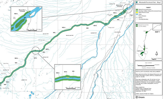
Missinaibi Provincial Park - Map 6
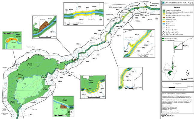
Missinaibi Provincial Park - Map 5
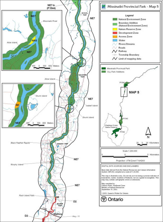
Missinaibi Provincial Park - Map 4
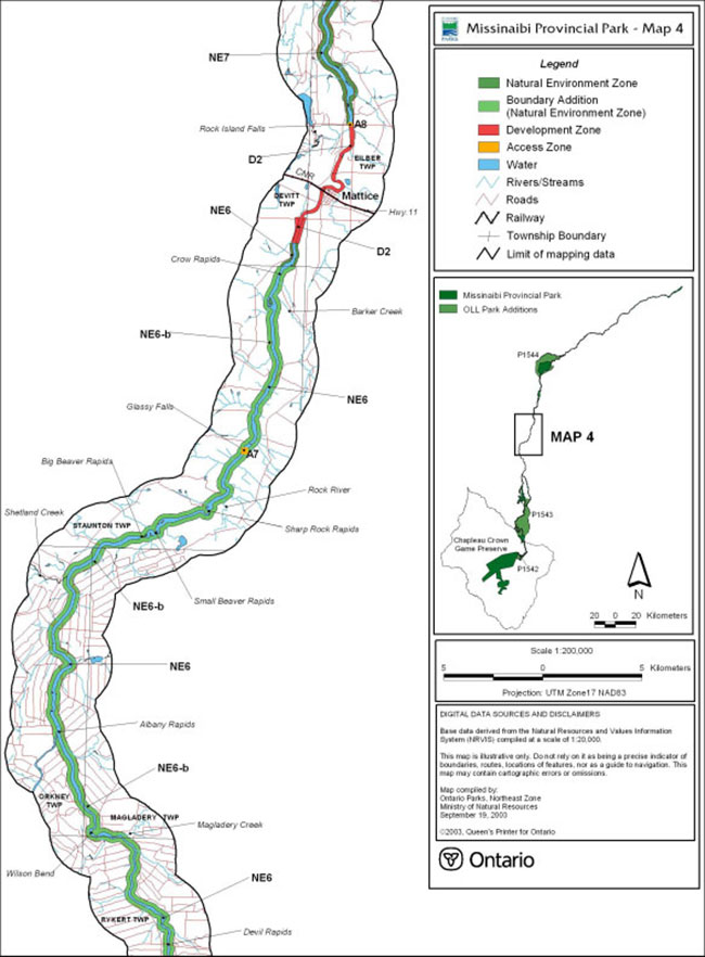
Missinaibi Provincial Park - Map 3
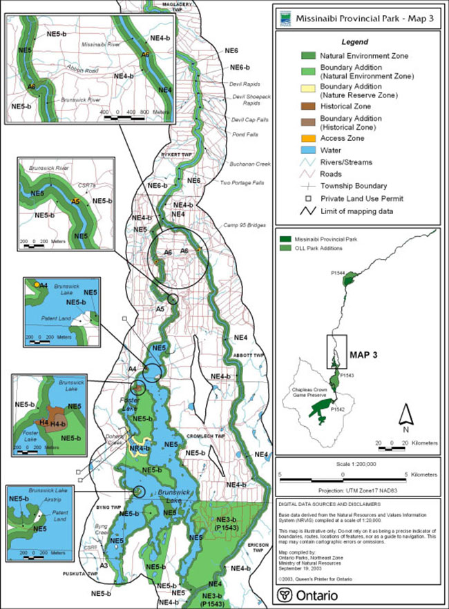
Missinaibi Provincial Park - Map 2
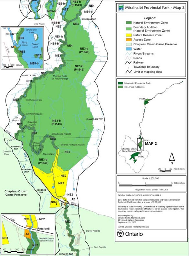
Missinaibi Provincial Park - Map 1
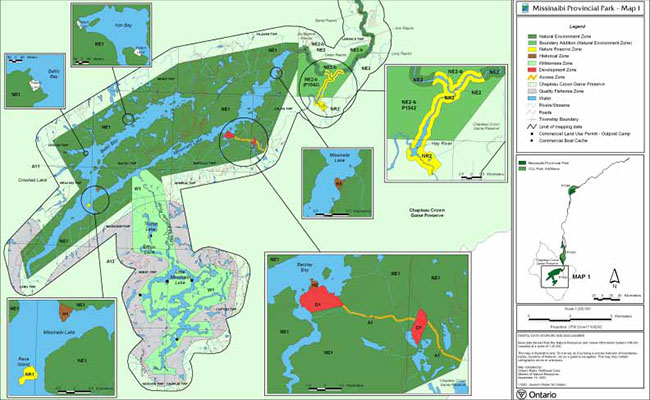
Missinaibi Provincial Park - Map 8
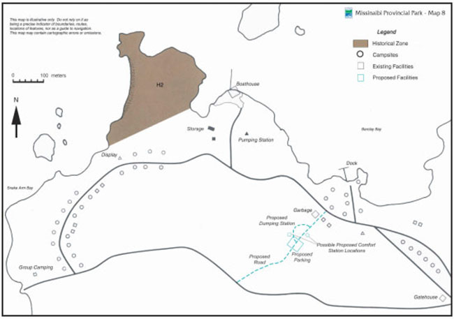
Footnotes
- footnote[1] Back to paragraph Missinaibi Park Management Plan has been developed in accordance with the Ontario Provincial Parks Planning and Management Policies (1992), Ontario’s Living Legacy Land Use Strategy (1999) and District Land Use Guidelines for the Ministry of Natural Resources Chapleau and Hearst Districts (1983). In accordance with this plan, MNR will amend the affected area-specific land use policies and mapping found in the Crown Land Use Policy Atlas.
- footnote[2] Back to paragraph "The Canadian Heritage Rivers System (CHRS) was established in 1984 by the federal, provincial and territorial governments to conserve and protect the best examples of Canada’s river heritage, to give them national recognition, and to encourage the public to enjoy and appreciate them. The goal is to establish a system that reflects the diversity of Canada’s river environments and celebrates the role of rivers in Canada’s history and society. The dream is to ensure that these rivers flow into the future with their heritage features protected for generations to come. All protective actions on Canadian Heritage Rivers depend on existing laws and regulations, and respect the rights of Aboriginal peoples, communities, private landowners, and other stakeholders." (Parks Canada - Canadian Heritage Rivers System)
- footnote[3] Back to paragraph In 1985, the Canadian Heritage River’s Board received Ontario’s nomination of the Missinaibi waterway as a Canadian Heritage River, and recommended designation of the river upon the submission of a management plan.
- footnote[4] Back to paragraph Biodiversity or biological diversity is the variety of organisms and the ecological complexes in which they occur.
- footnote[*] Back to paragraph Note: In the following sub-sections and on the corresponding maps, the "b" refers to park boundary additions identified in Ontario’s Living Legacy Land Use Strategy and Provincial Parks Council Recommendations.
- footnote[5] Back to paragraph In classifying Ontario’s natural heritage, the Province is divided into fourteen broad ecological regions. These "ecoregions" are areas of land where vegetation follows a consistent pattern in response to the landforms and climate. Each type of landform (defined in terms of relief, soil texture and depth, and drainage) within a specific site region has its characteristic plant succession. To ensure that an adequate example of each ecological region is protected, the Ontario Provincial Parks Planning and Management Policies (1992) direct that at least one wilderness park and one wilderness zone be established in each ecoregion. In Ecoregion 3E, Pukaskwa National Park and Little Missinaibi Lake and Thunder House Falls wilderness zones within Missinaibi Provincial Park represent the natural ecology of this part of Ontario, and are large enough to provide low-intensity, recreational experiences in a wilderness setting.
- footnote[6] Back to paragraph In a broad context, ecosystems refer to the inter-relationships between all life forms with their environments.
- footnote[7] Back to paragraph The term 'park values' should be interpreted broadly to include the natural, recreational and cultural values within the park as well as associated values found outside of the park. These associated park values include but are not limited to water quality, wildlife habitat, wilderness and aesthetics.
- footnote[8] Back to paragraph Identifying an "Area of Concern" is a technique used in forest management planning to draw special attention to a particular location for planning and operational purposes. Under this designation, the specific park related values should receive special consideration every time a proposal is put forth for resource use or development.
- footnote[9] Back to paragraph Benthos refers to small organisms that live on or in the bottom of water bodies. Plankton refers to organisms that are free swimming or suspended in the water.
- footnote[10] Back to paragraph The term "cumulative effects" is largely undefined in the scientific community. In this context it refers to the collective impact that resource utilization may have on park resources. The key requirement however is information about the resources. Therefore, the focus in this area will initially be on data collection.
- footnote[11] Back to paragraph Access restrictions were established to implement the direction set out in the Chapleau District Land Use Guidelines (1983) and the District Fisheries Management Plan (1989). These restrictions were established to maintain the remote wilderness character of the Little Missinaibi Lake area and the larger "Quality Fisheries Zone" adjacent to the park.
- footnote[12] Back to paragraph The use of two Camp 95 bridges continues to be reviewed through forest management planning.
- footnote[13] Back to paragraph The term "expanded existing crossings" refers to the re-construction of a bridge to enlarge its original engineered capacity. This excludes regular maintenance or upgrading to maintain safety standards.
- footnote[14] Back to paragraph This park management plan will be submitted to the Canadian Heritage Rivers Board. Upon their acceptance, the Missinaibi River will be designated as a Canadian Heritage River.