Mississagi Provincial Park Management Statement
This document provides policy direction for the protection, development and management of Mississagi Provincial Park and its resources.
Interim Management Statement
Approval statement
I am pleased to approve this Interim Management Statement (IMS) for Mississagi Provincial Park.
This IMS contains policy direction for the area of Mississagi Provincial Park regulated prior to July 1999, as well as for the addition provided by Ontario’s Living Legacy (OLL): Mississagi Provincial Park Addition (P191).
Mississagi Provincial Park, including the OLL addition (P191), is identified as a natural environment class provincial park and was regulated under the Provincial Parks Act in December of 2002 (O. Reg. 311/02).
This Interim Management Statement provides direction for the protection and management of Mississagi Provincial Park.
Signed by:
Paul Bewick
Zone Manager
Northeast Zone
Ontario Parks
Date: May 23, 2006
1.0 Introduction
Mississagi Provincial Park
There are ninety campsites in the campground and a few interior campsites that are accessible by canoe or park hiking trails. Lying within the Mississagi River watershed, the park area is renowned for its hiking trails, canoe routes, lake trout lakes and rugged landscapes. Recreational activities within the park include camping, boating, angling, canoeing, picnicking and swimming. The park and surrounding area also offer outstanding hiking opportunities with more than sixty kilometres of trails that traverse the rugged Penokean Hills.
Mississagi Provincial Park contains representative forests of sugar maple and yellow birch, with stands of white and red pine and some eastern hemlock. The maple-birch forest in the park marks the northern most contiguous range for these species in Ecoregion
The Mississagi Addition (P191) contains two provincially significant natural heritage areas: the extensive Stag Lake Peatland and the Boland River Valley. The Boland River Valley supports a variety of old forest communities, including white cedar and black ash swamps.
Mississagi Provincial Park and the adjacent areas are underlain for the most part by metamorphosed sedimentary rocks of the Lorrain, Gordon Lake and Bar River Formations of the Colbalt Group, Huronian Supergroup. These rocks include various mudstones, sandstones and conglomerates which were for the most part deposited as clay, sand and gravel by rivers flowing from predominantly granitic Archean craton lying to the north. The ripple marks found in some siltstones and sandstones of the park are primarily sedimentary features found in shallow marine and lake deposits, and are commonly preserved through lithification and low grade metamorphism. Sandstone and siltstone originated as sand and silt deposits in glacial lakes some 2.3 billion years ago; wave action in this marine environment created ripple marks on sand beaches which were preserved as these deposits lithified. The unofficial name for this ancient rock formation is "ripple rock".
Huge boulders known as "glacial erratics" are also found in the park. These were transported and scattered by the receding glaciers at the end of the last Ice Age, approximately 11,000 years ago. These erratics are composed of rock types that differ from the underlying bedrock. The most notable examples of glacial erratics in the park area are comprised of quartz pebble conglomerate and are located on the Helenbar and Cobre Lake trails.
The park contains several scenic lakes including Semiwite, Helenbar, Christman, Fullerton and a portion of Flack. Most range from 18-70 metres deep and are productive lake trout and brook (speckled) trout lakes. Most of the park lakes have broken rock shorelines, with a few beaches.
Wildlife found in the park includes white-Ontario is divided into 65 ecodistricts. An ecodistrict is a subdivision of an ecoregion based on a characteristic pattern of physiographic features, which set apart fairly large areas from one another. tailed deer, moose and black bear. In the vicinity of the campground, small mammals such as red squirrel, snowshoe hare, chipmunk, raccoon and beaver are common.
Mississagi is also host to abundant bird life. Near the campground, the most commonly sighted species include warbler, thrush vireo and flycatcher. Further afield there are populations of loon, kestrel, pileated woodpecker, osprey and northern (Baltimore) oriole.
Aboriginal people inhabited the park for several centuries and there is archaeological evidence of prehistoric habitation, most likely winter encampment sites of the Mississauga people. Evidence of the horse logging days of the late 19th and early 20th centuries can also be seen along Semiwite Creek, Semiwite Lake and Flack Lake trails.
2.0 Management context
The purpose of this Interim Management Statement (IMS) is to provide direction to ensure custodial management of park resources and infrastructure. If deemed necessary, a park management planning process may be conducted at a future date. At that time significant decisions not addressed in this IMS regarding resources stewardship, operations, development and permitted uses will be made.
Park Management will follow direction from:
- Provincial Parks Act (1990)
- This approved Interim Management Statement
- Ontario’s Living Legacy Land Use Strategy (1999), policy amendments (2000) as well as related policy clarification documents
- Ontario Provincial Parks Planning and Management Policies (1992)
2.1 Environmental assessment
As part of the Ontario Ministry of Natural Resources (MNR), Ontario Parks is a public sector agency that is subject to the Environmental Assessment Act. Management of Mississagi Provincial Park will be carried out in accordance with legislation, policies and guidelines that are required under the MNR Class Environmental Assessment for Provincial Parks and Conservation Reserves.
3.0 Classification
Mississagi Provincial Park is classified as a natural environment park in the Ontario Provincial Park System (one of six classes of Ontario’s Provincial Parks). This class of park recognizes the provincially and regionally significant natural and cultural features that occur in the park, and their need for protection.
Ontario Provincial Parks Policy (1992) states:
Natural environment parks incorporate outstanding recreational landscapes with representative natural features and historical resources to provide high quality recreational and educational experiences.
4.0 Goal
The goal of Mississagi Provincial Park is:
To protect a provincially significant landscape with associated representative plant, animal, geological and cultural features and to provide high quality recreation and heritage appreciation while contributing to local tourism.
5.0 Objectives
The management and operation of Mississagi Provincial Park will contribute to:
The achievement of Ontario Provincial Park objectives: protection, recreation, heritage appreciation, and tourism.
The objectives are described as follows:
5.1 Protection
To protect provincially significant elements of the natural and cultural landscape in Ontario.
The protection objective takes precedence over all other park objectives, governing all park planning, use and management. Any development for the park must be weighed against the environmental costs.
Mississagi Provincial Park protects significant biophysical and cultural resources, including:
- Representative earth science features in the Penokean Hills landscape with outcrops of quartzite, "ripple rock", glacial erratics, talus, valley sand plains, an extensive peatland and old growth red and white pine
- Representative vegetation associations for Ecodistrict 4E-3: hemlock stands, riparian areas, sugar maple and yellow birch forests and associated understory flora at the northern limit of their range in the ecodistrict
- Habitat for species at risk
- Historical and cultural features, including prehistoric habitation sites and remnants of more recent logging and mining history
5.2 Recreation
To provide outdoor recreation opportunities ranging from car camping and day-use to low-intensity backcountry experiences.
Mississagi Provincial Park provides outstanding opportunities for a variety of high quality recreational pursuits that are compatible with the natural character of the park. The main emphasis will be to provide a campground, and a variety of day-use activities such as hiking, canoeing, angling, boating and swimming. There are also backcountry camping, canoeing and hiking opportunities with more than sixty kilometres of trails associated with the park and surrounding area. (Section 9.3)
5.3 Heritage appreciation
To provide opportunities for exploration and appreciation of the natural and cultural heritage of Ontario.
Heritage appreciation is fostered by identifying recreational experiences for all park visitors, through the interpretation of park values, and the promotion of stewardship. It also communicates amenities available to the visitor and provides educational opportunities.
Individual exploration provides park visitors with a greater appreciation and understanding of Mississagi’s natural and cultural resources. Brochures for hiking trails and associated canoe routes provide information to park visitors.
The park’s Natural Heritage Education program is self-use. Natural heritage education at Mississagi Provincial Park is provided through the use of park promotional materials, signs and information kiosks, maps, trail guides, park tabloids and newsletters. Enhancement of self-use programs, park promotion, and special events will encourage greater use of the park. (Sections 8.3, 9.1)
5.4 Tourism
To provide residents of Ontario and non-resident visitors with opportunities to discover and experience a distinctive region of the Province.
The tourism objective supports partnerships with neighbouring communities. Mississagi Provincial Park plays an active role in attracting tourists to the Elliot Lake area. Four season benefits may be promoted in the future, particularly activities such as cross-country skiing and winter camping. The direction of visitors to facilities and services outside the park is supported, as is the cross-promotion of park attributes with local services. (Sections 9.4, 9.5, 9.6)
According to Park User Surveys, visitors tend to use Mississagi as a "destination" park, rather than as a "stop-over" park. Most park visitors are residents of Ontario (79%), and many residents of Elliot Lake visit the park for day-use opportunities, in particular for angling and hiking. Visitation from other provinces account for 10% and visitors from the United States and other locations account for 11% (1998, 1999 & 2000 Ontario Parks – Park Statistics).
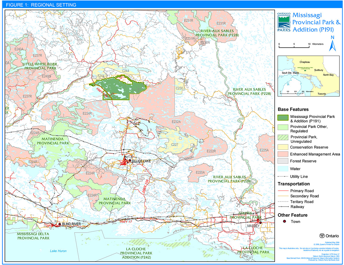
6.0 Park boundary
(Figure 2)
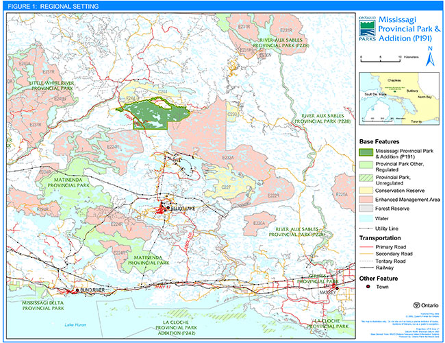
Mississagi Provincial Park is situated within the geographic Townships of Hembruff, Raimbault, Sagard, Veil, and Hughson in the Territorial District of Algoma. Highway 639 and associated right-of-way are under the jurisdiction of the Ministry of Transportation (MTO), who are responsible for construction, maintenance and management of the roadway.
When the park opened in 1965, it comprised an area of 3,160 hectares. In 1973 the park was officially regulated under the Provincial Parks Act (O. Reg. 111/73). In 1988, an additional 1,740 hectares extended the park boundary to the east and slightly to the south in order to include significant geological features, all of Helenbar Lake, and established hiking trails. This addition brought the regulated park boundary to an area of 4,900 hectares (O. Reg. 259/89, Schedule 108).
The Mississagi Addition (P191) as identified in Ontario’s Living Legacy Land Use Strategy (1999) added another 3,574 hectares of land to the park bringing the total area within the boundary to 8,474 hectares. The addition consists of two natural heritage areas in Ecodistrict 4E-3 identified as the Stag Lake Peatland and the Boland River Valley. The new park boundary was regulated in 2002 under the Provincial Parks Act (O. Reg. 311/02).
Ontario’s Living Legacy Land Use Strategy (1999) also identifies Enhanced Management Areas (E232a, E224r), a Conservation Reserve (C244), and a Forest Reserve (F339/F244) adjacent to the park. (Section 8.1.2) (Figure 2)
A park boundary sign plan will be prepared and implemented. Appropriate signage is particularly important on the south side of the Boland Road.
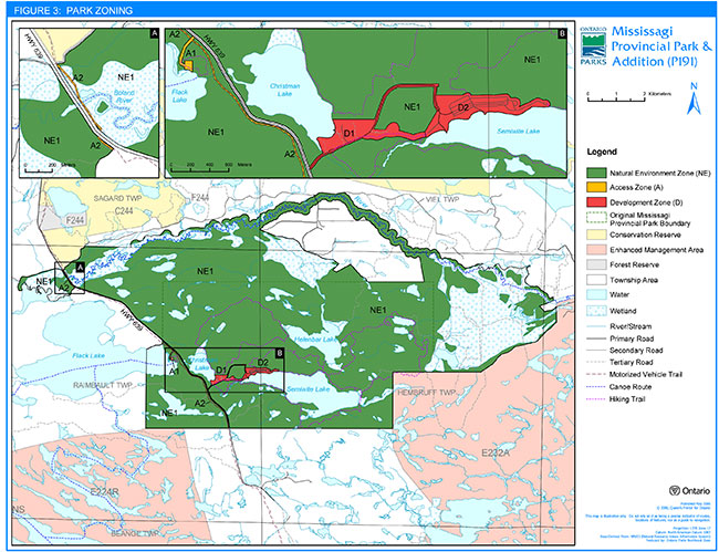
7.0 Zoning
(Figure 3)
Natural environment class parks may contain six possible land use zones: access, development, nature reserve, natural environment, historical and wilderness. Each zone permits certain land uses and outlines park management strategies. These zones guide the management and development of the park.
Three zones have been identified for Mississagi Provincial Park based on its operations and existing infrastructure and development. The zoning map delineates these zones which are distinguished by their protection and management needs, permitted levels of recreational use, and degree of access and development.
The zones identified in this Interim Management Statement are subject to refinement when a full park management planning process occurs.
Resource management policies related to zones in a natural environment class park are identified in:
- This approved Interim Management Statement
- Ontario Provincial Parks Planning and Management Policies (1992)
- Ontario’s Living Legacy Land Use Strategy (1999), policy amendments (2000) as well as subsequent OLL policy clarification statements for provincial parks
7.1 Natural Environment zone (NE)
(Figure 3)
Natural environment zones include natural landscapes in which there is a minimum of development permitted to support low-intensity recreational activities. Development will be limited to portages, trails, signs necessary for route identification and minimal interpretive facilities which support low intensity recreational uses.
NE1 Penokean Hills
This zone includes the majority of the park except for those areas designated as development or access zones.
Included in this zone are two provincially significant natural heritage areas identified in Ontario’s Living Legacy Land Use Strategy (1999): the Boland River Valley and the Stag Lake Peatland.
The Boland River Valley is lined with old black spruce forests as well as some old white cedar swamps. Tamarack and balsam fir also grow in these rich swamp forests. On the slopes and in drier parts of the valley, old white pine, white spruce, sugar maple, balsam fir and trembling aspen dominate the forests.
The Stag Lake Peatland is an extensive peatland which developed on top of glacial outwash deposits between Stag Creek and the Boland River. Much of the peat mat is open or supports sparse tree cover.
7.2 Access zones (A)
(Figure 3)
Access zones serve as staging areas and are a means of providing and regulating use of the park. Generally, development is limited to roads, small parking areas, visitor control structures, appropriate signage, a boat launch and basic day-use facilities.
A1 Flack Lake
This access zone is an existing access point on the west side of the park, which provides access to the east shore of Flack Lake. It is accessible only from Highway 639 and is situated three kilometres north of the park gate. Facilities include a boat launch, dock, vault privies, picnic tables, a fee station, parking area, and the one kilometre Flack Lake Hiking Trail.
A2 Dunlop- Mount Lake Trail
This zone incorporates the existing Dunlop-Mount Lake Trail which is the only authorized trail for motorized vehicles. Access and use of this trail is granted through a land use permit and will be limited to snowmobiles. ATVs may be permitted in the future. (Section 9.3.3)
7.3 Development zones (D)
(Figure 3)
Development zones encompass facilities and services for a wide range of day-use and camping activities. The development zone delineates those areas in the park with established development and includes buildings, the campground, roads, parking lots and day-use facilities.
There are two development zones in Mississagi Provincial Park, both of which are situated in the vicinity of the main park road.
D1 Park facilities and roads
This zone, located off Highway 639, includes the main park road as well as the areas where the old superintendent’s quarters, gatehouse, park office, maintenance facilities and staff quarters are located. The zone also includes the trailer dumping station, wood yard and telecom shack.
D2 Campground and day-use area
This zone provides facilities and services for a range of day-use and camping activities. It includes a campground with ninety campsites, a day-use area, group camping, a beach and picnic area as well as two boat launches and a docking facility.
This zone also includes the potential site for the construction of a comfort station.
8.0 Resource stewardship policies
Mississagi Provincial Park will be managed according to:
- Planning and management policies for natural environment class provincial parks identified in Ontario Provincial Parks – Planning and Management Policies (1992)
- Ontario’s Living Legacy Land Use Strategy (1999) and subsequent amendments and policy clarification statements
- The Environmental Assessment Act
- This approved Interim Management Statement
- Minimum operating standards.
A Park Operating Plan is required for the infrastructure in the park. This will reflect provincial operating standards and will be kept current to implement and guide the specific operational aspects of managing the park. (Section 9.0)
Although the policies herein are presented in separate categories, planning and management recognizes that the components are interrelated and that operations will ensure overall park objectives are achieved.
8.1 Terrestrial ecosystems
8.1.1 Earth science
The underlying geology and bedrock-controlled topography are the basis of the park’s scenic landscapes. On the diabase cuesta ridges, escarpments with associated talus slopes are common. Sandy areas are usually level, with some local kame and esker ridge complexes. The park contains some significant geological features including "ripple rock", glacial erratics, talus slopes and quartz conglomerate.
Earth science features will be managed to allow naturally occurring geological processes to continue. As per the Provincial Parks Act, unacceptable activities such as rock collecting and campfires on significant geological features will be prohibited.
8.1.2 Adjacent land management
Land uses or management of areas adjacent to Mississagi Provincial Park may have implications for park management. Forest management interests, MNR, the Park Superintendent and other agencies will work together to ensure that adjacent land uses do not affect the park environment (e.g. park canoe routes, hiking trails, viewsheds and aesthetic value) and park visitor experiences.
Forest operations
The 2005-2010 Forest Management Plan for the Northshore Forest identifies and provides direction for an Area of Concern (AOC) which involves a reserve consisting of a thirty metre (30m) modified area measured from the park boundary line. Normal operations are permitted in this AOC
No tertiary roads or trails are permitted in the AOC unless agreed to by the MNR. Tertiary roads and trails are to be kept to an absolute minimum within four hundred metres (400m) of the park boundary.
There is a forest plantation south of the Boland River which is surrounded by Mississagi Provincial Park. In order for forest operations to occur within this plantation access will be permitted over a temporary bridge crossing. The bridge will be signed to prohibit unauthorized access and the supporting structure will be removed when harvesting activities are complete.
Adjacent areas – Ontario’s Living Legacy
Ontario’s Living Legacy Land Use Strategy (1999) contains two types of geographic-specific land use categories – Land Use Designations and Enhanced Management Areas (EMAs). Mississagi Provincial Park is surrounded by a variety of these areas. (Figure 2)
The following are the adjacent areas identified in Ontario’s Living Legacy Land Use Strategy (1999):
Rawhide Lake Conservation Reserve (C244)
Conservation Reserves (CRs) complement Provincial Parks in protecting representative natural areas and landscapes. Rawhide Lake Conservation Reserve encompasses approximately 4,673 hectares and is located to the north of the Mississagi Provincial Park. This conservation reserve includes an important cultural site, which has spiritual significance for Aboriginal peoples.
Area from the Cobre Lake Old Pine Forest Reserve (F339) has been added to this site as it is no longer under mining tenure. However, a small area still remains part of the Cobre Lake Old Pine Forest Reserve (identified as F244).
Cobre Lake Old Pine Forest Reserve (F339/F244)
Forest Reserves are areas where protection of natural heritage and special landscapes is a priority, but some resource use can take place with appropriate conditions. Cobre Lake Old Pine Forest is comprised of approximately 140 hectares and is located to the northwest of the park. This forest reserve is an old growth pine forest and when areas are not under mining tenure it will be regulated as part of the Rawhide Lake Conservation Reserve. In the interim, this area will be managed to protect natural and recreation values of the adjacent conservation reserve and the trail system.
Matinenda Lake Enhanced Management Area (E224r)
EMAs are a land use category established through Ontario’s Living Legacy to provide more detailed land use direction in areas of special features or values. A wide variety of resource and recreational uses can occur in EMAs. Matinenda Lake Enhanced Management Area (EMA) encompasses approximately 31,314 hectares and is located southwest of the park. This recreational and resource sector area (forestry, mining) will be managed according to remote access policies outlined in Ontario’s Living Legacy Land Use Strategy (1999).
Whiskey-Quirke Lakes Enhanced Management Area (E232a)
Whiskey-Quirke Lakes Enhanced Management Area is located southeast of the park and encompasses approximately 33,003 hectares. This EMA will be managed according to remote access policies outlined in Ontario’s Living Legacy Land Use Strategy (1999), and in the MNR District Land Use Guidelines (Blind River and Espanola).
8.1.3 Mineral exploration
Mineral exploration and mining is not permitted within the regulated boundary of Mississagi Provincial Park.
8.1.4 Vegetation management
The management of vegetation will be directed toward promoting a healthy and natural diversity of vegetation in Mississagi Provincial Park. The park protects a representative sample of the Transition Forest and Ecodistrict 4E-3. Regionally significant species have been identified in the park. These species occur at the northern limit of their range, and include ironwood, Virginia creeper and red oak. The park also contains eastern hemlock at its northern range limit.
A Vegetation Management Plan may be prepared for the park. The plan would include campground and day-use areas to ensure the maintenance of forest cover and a safe and aesthetic setting for visitors. The emphasis of vegetation management will be to allow flora to evolve naturally. The vegetation resources of the park will be managed to:
- Allow natural processes and evolution of various vegetation communities in the park
- Protect rare or endangered plant species that may be identified; and
- Maximize buffers in the campground and in access zones, while ensuring public safety
Vegetation control
Generally, trees may be removed from development, access or natural environment zones if there is a threat to public safety or to facilitate capital construction or for resource management purposes. These trees may be marketed if economical.
Non-native plant species will not be deliberately introduced. Where they are already established, and threaten park values, management will develop a program for their eradication. Missing native plant species may be re-established if biologically feasible and acceptable.
Insects and disease
Insects and disease may be managed where aesthetic, cultural, or natural values are threatened. Where information is found to warrant management controls, problem areas will be narrowed so as to minimize effects on other components of the park environment. Guidelines established by the Ontario Ministry of Natural Resources and the Ontario Ministry of Environment will be implemented. Biological controls will be used in preference to chemicals, where feasible.
Forest fire management
MNR and Ontario Parks recognize fire as an essential ecosystem process, fundamental to restoring and maintaining the ecological integrity of protected areas. In consultation with the MNR – Fire Management Section, a Fire Management Plan may be prepared, by Ontario Parks, or in consultation with Ontario Parks for Mississagi Provincial Park. The plan will identify management and protection priorities relating to the use of fire, fire prevention and suppression activities in the park.
In the absence of a specific fire management plan for the park, fire management will be carried out as on adjacent public lands in accordance with the Forest Fire Management Strategy for Ontario and the Great Lakes/St. Lawrence Zone designation identified in that strategy. "Light on the Land" fire suppression techniques will be used, wherever feasible, when protecting sensitive features.
Protection from fire will be provided in all cases where life and property are threatened.
8.1.5 Wildlife management
The management of wildlife in the park will be directed toward promoting healthy and diverse populations. Wildlife viewing and birding will be encouraged, activities that are enhanced by the park’s numerous hiking trails.
A Wildlife Management Plan may be prepared.
Select controls of animal populations will be implemented under the strict supervision of the Park Superintendent, or directly by the Ontario Ministry of Natural Resources. Such control will only be directed at populations requiring attention.
Vulnerable, Threatened & Endangered Species (Species at Risk)
There are species at risk within the park. Further studies or inventories may be conducted. Information gathered on species at risk will assist in the development of management practices.
Hunting
Hunting is not permitted within the regulated (O. Reg. 259/89, Schedule 108) boundary of Mississagi Provincial Park except for the park addition as defined in Ontario’s Living Legacy Land Use Strategy (1999). The Fish and Wildlife Conservation Act, the Migratory Birds Act, and the Ontario Hunting Regulations Summary are applicable to any hunting activity within the park.
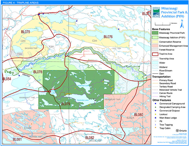
Trapping
There are portions of two existing trap lines (BL04NO78 & BL04NO79) within Mississagi Provincial Park (O. Reg. 259/89, Schedule 108). These two existing trap lines also include portions of the Mississagi Addition (P191). There is also one trap line (BL03NO76), which includes portions of the Mississagi Addition (P191). (Figure 4)
As per Ontario’s Living Legacy Land Use Strategy (1999), existing commercial fur harvesting may continue indefinitely within the Mississagi Provincial Park boundary.
Within the Mississagi Addition (P191) there is a trap cabin located on Cabin Lake (part of trap line BL04NO78). Any relocation of the existing cabin and trails will be subject to ecological principles and consideration of park values.
New operations including trap line cabins and trails will not be permitted in Mississagi Provincial Park. However, licenses may be issued or transferred where records show that trapping has been a licensed or permitted activity since January 1, 1992.
If a commercial licence is revoked or surrendered, all portions of the registered trap line within Mississagi Provincial Park will be rescinded from the trap line’s legal description.
In order to allow authorized commercial fur harvesters to access their trap lines within the park, an access agreement may be established between Ontario Parks and the trapper. Protection of park values will be a priority.
First nations
Status Indians exercising treaty rights are permitted to continue commercial fur harvesting in Mississagi Provincial Park subject to applicable legislation and regulation.
Transfer of trap lines is permitted only between Status Indians. Only Status Indian trappers' helpers are permitted to assist Status Indian trappers.
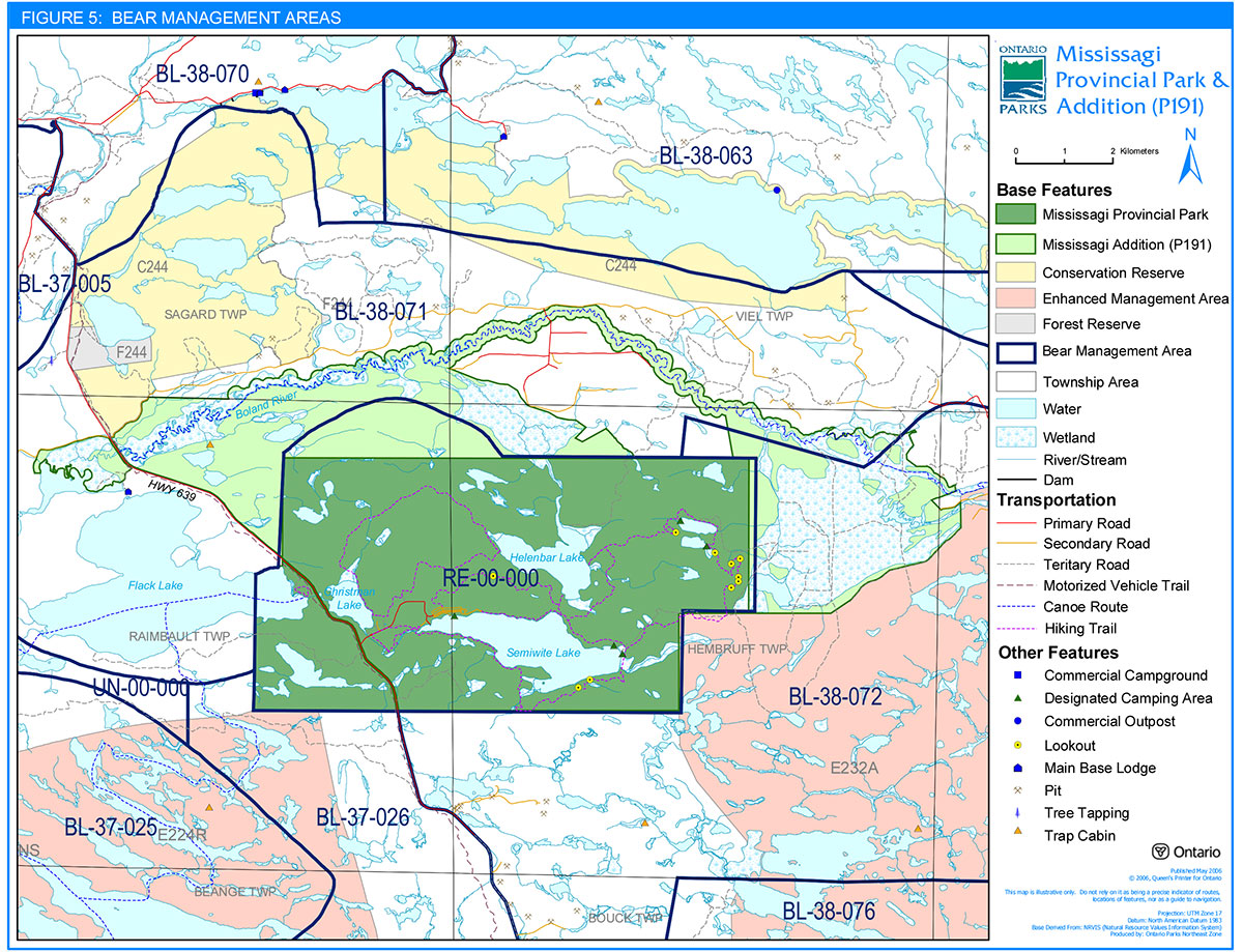
Bear Management Areas
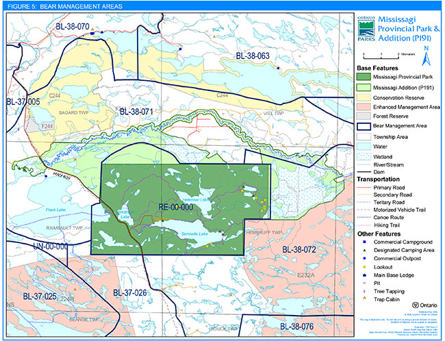
There are no Bear Management Areas (BMAs) in Mississagi Provincial Park (O. Reg. 259/89, Schedule 108). However, there are portions of two BMAs (BL38071 & BL38072) located in the Mississagi Addition (P191). At this time, licensing of commercial bear hunting in BMAs may continue within the Mississagi Addition (P191). New BMA licences will not be issued. An existing authorized BMA licence may be renewed or transferred. Renewal and transfer will consider conservation principles and public safety. (Figure 5)
8.1.6 Waste management
Sewage and solid waste within Mississagi Provincial Park is disposed of outside the park through licensed local contractors and facilities.
Conforming to Ministry of Environment approved standards and guidelines the sewage lagoon and sludge pit were decommissioned. The decommissioned sewage lagoon is located up the hill from the park office. Access to the decommissioned sludge pit is possible via the road leading through the old wood yard.
Waste containing natural materials, such as leaves and grass clippings, will be reused or composted inside the park where feasible and appropriate. Otherwise, all solid waste will be removed from the park for recycling or disposal.
8.2 Aquatic ecosystems
There are several lakes and creeks of varying sizes and characteristics in the park. The management of the park’s resources will emphasize the maintenance of good water quality and sufficient water flow for fisheries habitat and recreational purposes.
8.2.1 Water quality
The Ontario Ministry of Natural Resources will monitor water quality (drinking and beach) on a regular basis to ensure human health and safety.
Christman Lake (Jim Christ) is the park’s source of drinking water.
8.2.2 Fisheries management
Park fisheries will be managed to protect existing stocks and sustain fishing opportunities within the limits of the park lakes' natural capacities to produce fish.
In general, fisheries management of park lakes is identified in guidelines outlined in the Blind River District Fisheries Management Plan (1989-2000). The sport fishery in the park will continue to be managed through regulations under the Fish and Wildlife Conservation Act and the Fisheries Act. The park is situated within Division 18 (Ontario Recreational Fishing Regulations Summary), and certain restrictions apply therein, particularly concerning winter fish sanctuaries.
Angling restrictions
Most park lakes are closed to fishing during the winter months. Angling is not permitted during the dates identified in the Ontario Recreational Fishing Regulations Summary.
Angling during the winter season, within the regulated park boundary, may be reviewed and sanctuaries for other lakes may be considered for management purposes. Ontario’s Living Legacy Land Use Strategy (1999) permits angling to continue unless a specific fish sanctuary is established under the Fisheries Act.
Sport fishing
Numerous fish species such as lake and brook trout are found within park lakes. Sport fishing is a very popular activity for park visitors. Flack, Semiwite, Christman, and Fullerton lakes all have naturally reproducing lake trout populations and comprise the major angling resources in the park. An assessment of park fisheries may be conducted.
It is illegal to harvest bullfrogs or snapping turtles in provincial parks (OMNR 2005b).
Bait fish
As per provincial park policy for natural environment class parks, the use or possession of bait fish is prohibited in water bodies entirely within the park boundary.
Fish stocking
Some of the lakes within Mississagi Provincial Park are part of a regular brook trout stocking program. District MNR and Ontario Parks will continue to monitor the activity of stocking fish. Stocking programs must avoid actions that would affect native populations.
Non-native fish introductions
Non-native fish species will not be introduced. The introduction of non-native species may affect the park’s populations of lake trout and brook trout.
To help deter the introduction of non-native species into park lakes, information will be provided to the public about the issue of unwanted introductions.
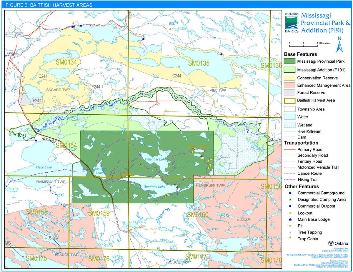
Commercial bait fishing
There are no bait fish operations within Mississagi Provincial Park (O. Reg. 259/89, Schedule 108), however, there is one bait fish operation in the south half of Veil Township, which is located in a portion of the Mississagi Addition (P191). (Figure 6)
As per Ontario’s Living Legacy Land Use Strategy (1999), commercial bait fishing will continue in the Mississagi Addition (P191), subject to possible conditions identified in Fisheries Management Plans.
No new bait harvesting licenses will be permitted, however, active licenses may be transferred where commercial bait harvesting activities have been licensed or permitted since January 1, 1992.
8.3 Cultural resources management
A detailed inventory of the cultural features of the Mississagi Addition (P191) has not been completed at this time. There has been some research completed for the original park in the form of an archaeological survey conducted in 1974.
The management of cultural resources within the park will be directed at protection and heritage appreciation. Cultural heritage sites will be protected and any use of these sites that is incompatible with cultural values will be prohibited. It is recommended that further research be undertaken to identify archaeological and historic sites (Section 9.2). Park cultural themes that may be further utilized for heritage appreciation include prehistoric habitation and sites with historical logging significance. These could be interpreted through self-use programs (self-guiding brochures, interpretive signs, etc.) or through a more active Natural Heritage Education program. (Section 9.1)
One of the park’s most remarkable stories dates from 1946 when a Gloster Meteor crashed in Helenbar Lake. The plane was salvaged by the military but some pieces remain on the shore of Helenbar Lake. The McKenzie Trail is named after the pilot. This site will be protected and any use that is incompatible with its values will be prohibited.
9.0 Operations policies
Mississagi Provincial Park will be managed in accordance with the following:
- Provincial Parks Act and regulations
- Planning and management policies defined in Ontario Provincial Parks – Planning and Management Policies (1992)
- Ontario’s Living Legacy Land Use Strategy (1999) and subsequent amendments and OLL policy clarification statements for provincial parks
- The Environmental Assessment Act
- This Interim Management Statement
- Minimum operating standards.
A Park Operating Plan will be prepared to provide staff with the necessary operational information to carry out day-to-day park operations. The Operating Plan will also address budgeting, staffing, maintenance schedules, enforcement, and emergency services. The provisions of the Operating Plan will be consistent with the approved Ontario Provincial Park Operating Standards (1992) and will be reviewed annually and updated as required.
9.1 Natural Heritage Education
Natural heritage education will be managed in accordance with this Interim Management Statement and Provincial Park Operational Policies, Procedures, and Standards. A Natural Heritage Education Plan will be prepared.
The primary purpose of natural heritage education will be to inform park visitors about natural and cultural resources unique to Mississagi Provincial Park, as well as recreational activities and services in the park and surrounding area. Approaches such as publications, display panels and self-guided trails will be the main methods used. Direction for natural heritage education will be taken from provincial park policies (PM 6.02).
Information
Information about park resources, management facilities, programs, and nearby attractions and services will be made available to the public. This information will be disseminated at key points throughout the park, such as the park office, gatehouse and bulletin boards.
Interpretation
Interpretive information about natural and cultural features in the area will be provided through park literature. Some interpretive programs may be offered on a limited basis (e.g. guest speaker).
The park provides an excellent base for groups to explore and learn about the natural and cultural resources of the area. Groups and individuals will continue to be encouraged to use the park for educational purposes that are compatible with park policies.
Recreation
Recreation information will acquaint park visitors with recreation opportunities and facilities available in the park and area. Where required, information will be portrayed to improve visitor skills in order to ensure safe use and maximum enjoyment of the park. Some recreational skill instruction may be provided on a limited basis.
9.2 Research
Scientific research, by qualified individuals, which contributes to the knowledge of natural and cultural history and to environmental and recreational management, will be encouraged in the park. Ontario Parks will encourage institutions to undertake research projects. All research programs will require the approval of Ontario Parks and will be subject to park policy and other applicable Legislation. Ontario Parks may approve the research of any natural or cultural specimens by qualified researchers. All such materials removed remain the property of Ontario Parks.
Approved research activities and facilities will be compatible with the park’s protection objective. Any site which is affected will be rehabilitated as closely as possible to its original state.
Vegetation plot sampling in the vicinity of Helenbar Trail, an aquatic vegetation study on Semiwite Lake and gypsy moth sampling by the Canadian Forest Service’s Pest Management Institute in Sault Ste. Marie are examples of research that have occurred within the park.
Appropriate research topics to further a knowledge of the park and adjacent management areas include: species at risk, earth and life science studies (especially in the Mississagi Addition, P191), and further investigation of archaeological and historical sites in the park. (Section 8.3)
9.3 Recreation management
Mississagi Provincial Park provides outstanding opportunities for a variety of high quality recreational uses compatible with the natural character of the park. Recreation management will be directed toward the provision of moderate to low intensity recreational activities. Backcountry hiking and canoeing are common day-use activities and are also complementary to camping in the campground. Other day-use opportunities include: angling, boating, canoeing, picnicking and swimming.
Detailed guidelines and procedures for the management and operation of park activities and facilities will be incorporated into the Operating Plan for the park.
9.3.1 Hiking
There are over sixty kilometres of hiking trails associated with the park and area. The following trails are located within the park: Helenbar Lake (7km), Jimchrist (11km), Semiwite Lake (12km), Semiwite Creek (1.2km), Flack Lake (0.8km), and the McKenzie (22km). The latter trail offers extended overnight hiking with four interior campsites. The Cobre Lake Trail (11km) is located in the Rawhide Lake Conservation Reserve outside the park, approximately eleven kilometres north of the park entrance. Old Baldy Trail (5km) is also located outside the park, however it is only accessible by boat. This trail starts on the shores of Flack Lake’s west end.
Visitors participating in interior hiking and canoeing activities will comply with all safety precautions and low impact camping ethics.
9.3.2 Cross-country skiing / Snowshoeing
Snowshoeing and cross-country skiing are permitted within the park.
Trails and roads (e.g. campground) within the park are not groomed for cross-country skiing, however, partnership opportunities may be explored to provide groomed and maintained ski trails within the park.
9.3.3 Authorized trails for motorized vehicles
The only authorized trail for motorized vehicles within the park is the existing Dunlop-Mount Lake Trail (Figure 3) along the Highway 639 corridor. Access and use of this trail is granted through a land use permit and will be limited to snowmobiles. ATVs may be permitted in the future. This trail will be monitored and subject to conditions identified within individual Memorandums of Understanding between Ontario Parks and the local snowmobile and ATV clubs. Failure to comply with conditions identified in the agreement may result in termination of use.
Snowmobiles
Snowmobile access through the park to lakes within and outside of the park is not permitted. Off-trail snowmobile use is not permitted within the park. Use of snowmobiles is restricted to the authorized Dunlop-Mount Lake Trail.
All Terrain Vehicles
Use of the authorized snowmobile trail (Dunlop-Mount Trail) by ATVs may be permitted. At this time, the authorized snowmobile trail is not appropriate for the use of ATVs and would require upgrading (e.g. trail hardening, cutting trees/stumps, bridges in wet areas, etc). Protection of the park environment (e.g. soil compaction/erosion, access, vulnerable, threatened and endangered species, ripple rock, etc.) and visitor safety is the priority. The snowmobile trail crosses the Flack Lake Access Road. Safety of park visitors using the Flack Lake Access and trail is of the utmost importance.
Of particular concern is the area where the trail crosses the wetland on the east side of the Boland River. Prior to any trail improvement projects, more information about the features of the area must be gathered to ensure adequate mitigation measures are taken. Any development will be subject to the requirements of the Environmental Assessment Act.
The use of ATVs on designated roads within the campground may be permitted at the discretion of the Park Superintendent.
Off-road use of ATVs will not be permitted within park boundaries unless authorized by the Park Superintendent under the authority of the Provincial Parks Act.
9.3.4 Recreational watercraft
As per the Provincial Parks Act, "no person shall launch, operate or possess a boat, water-ski, sailboard, surfboard, water sled or any like thing in any water in a Provincial Park that is designated as a swimming area or upon any part of a beach adjacent there to."
In the event that the use of recreational watercraft compromises park objectives and visitor safety, regulations will be pursued to restrict use on lakes within the park.
9.3.5 Boat caches
There are no authorized boat caches within the park.
As stated in the Provincial Parks Act, watercraft are not permitted to be left unattended in the park without written permission from the Park Superintendent.
9.3.6 Aircraft
As per the Provincial Parks Act, aircraft are not permitted to land in the park. However, aircraft will be permitted to land in the park for the purposes of maintenance, and in emergency situations.
9.3.7 Mountain biking
Bicycles will not be permitted on hiking trails. Mountain biking has occurred in the park, on the Jimchrist Trail. However, this trail is currently not appropriate for this use.
Further studies (e.g. user survey) may be conducted to determine the role of mountain biking in the park. Should studies indicate that mountain biking serves a viable role for park tourism and meets the park goal and objectives, site planning will evaluate the provision of upgrading appropriate trail infrastructure to ensure the protection of park values. Any development will be subject to the requirements of the Environmental Assessment Act.
9.3.8 Unauthorized camping
Unauthorized camping has been occurring at various locations in the park. Camping anywhere other than a designated campsite is prohibited. Park promotional material and restricted access signs will be posted at known points of entry (e.g. trailhead).
9.3.9 Unauthorized access
There has been unauthorized access into the park at a number of locations. Park boundary signs will be posted at all necessary areas.
9.4 Tourism strategy
A Tourism Strategy may be developed for Mississagi Provincial Park and will be reviewed and updated as necessary.
9.5 Marketing
A Park Marketing Strategy may be prepared and will provide recommendations to increase public awareness of park facilities and recreational opportunities. With the Mississagi Addition (P191), more recreation opportunities are provided for the park visitor. Promoting interior use of the park for hiking, canoeing and camping will serve to increase visitation, as may encouraging winter use of the park (e.g. snowshoeing).
Park promotion will encompass many communication methods including: marketing at tourism centres and prominent and attractive signage in the park. Partnerships with school groups and local businesses, which utilize the park for recreational and educational programs, may also be promoted.
The updating, reprinting and distribution of the Mississagi Park brochure, canoe route and hiking trail brochures and tabloid is important for raising public awareness of the park. Also pertinent to marketing is the promotion of energy efficient technologies within the park.
9.6 Tourism services
Opportunities to increase visitation and revenue to the park, and directly benefit the City of Elliot Lake, will be explored.
Mississagi Provincial Park is used for both day-use and camping. Mississagi Provincial Park is particularly well used by visitors from the City of Elliot Lake, who commonly visit the park for a variety of reasons: day outings, short and long-term camping, educational outings from schools and businesses. Angling, hiking, boating, canoeing and swimming are popular park activities. During autumn, the park area is renowned for its fall colours.
9.7 Partnerships
There may be opportunities for the Park Superintendent to work with partners (e.g. City of Elliot Lake, naturalist groups, etc.) provided that activities are consistent with park values. The goal of partnerships is to reduce operating and capital costs, and to increase revenues and park visitation. Mutually beneficial proposals may be explored however, the protection of park values is of primary importance.
10.0 Development policies
Infrastructure to protect park features and values will be permitted and developed in response to use, environmental deterioration and environmental protection requirements. All development must meet the requirements of the Environmental Assessment Act. Development will be implemented through work program planning, based on priority and the availability of funds, possibly with the aid of partnerships. Any development will be implemented in accordance with approved site and development plans, which detail the location, type and extent permitted.
Development policies for the park are as follows:
10.1 Comfort station
Due to the increasing demand for more camper amenities, particularly showers and flush toilets, a comfort station may be constructed. An approved site plan has been developed and it determined that the most suitable location for the comfort station is in Development Zone-2 (Figure 3).
This facility will be accessible to persons with disabilities and will include flush toilets and showers. Any construction is subject to the requirements of the Environmental Assessment Act.
10.2 Expansion of trail system
If there is an identified need, the existing trail system may be expanded. Infrastructure to manage impact and access will be permitted at trailheads where necessary. Any new development is subject to the requirements of the Environmental Assessment Act.
10.3 Log cabin
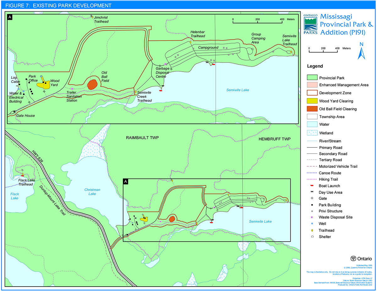
The "log cabin" is situated on Christman Lake near the Park Office. The MNR Junior Rangers constructed it during the summers of 1976-78. The building is currently used by park staff and other groups for events such as meetings, training, slide shows and winter experiences. Structural deterioration has occurred to the point where repairs to the building are necessary in the immediate future.
Development plans will determine the repairs required to improve the structure of the log cabin. The current location of the log cabin is not suitable for public roofed accommodation, as it is too close to staff areas and the pump house/generator building (Figure 7).
10.4 Alternate Energy/Energy Efficiency project
Mississagi Provincial Park was selected as a site for participation in the Elliot Lake Area Energy Efficiency Program. The park, with assistance from Ontario Hydro Technologies, initiated this project in an attempt to minimize dependency on fossil fuels, and therefore become a more "environmentally friendly" park. There were two phases of this project: Phase 1 included the introduction of new solar lights at several locations in the park (gate house, the day-use boat launch area, camper boat launch area, and the intersection between the campground and day-use area). There are also solar lights installed in six sets of vault privies in the campground. Phase II included energy efficient lighting and an inverter. This system works in conjunction with a large battery bank and will be reviewed and upgraded as necessary.
10.5 Picnic shelter
Construction of a picnic shelter in the day-use area may be considered. An approved site plan will be required prior to construction. Any development will be subject to the Environmental Assessment Act.
10.6 Backcountry campsites
Existing backcountry camping will be permitted to continue unless park features are threatened. To manage impact campsites will be designated. An interior camping permit will be required for the use of these campsites.
Infrastructure to protect park features and values will be permitted and developed in response to use, environmental deterioration and environmental protection requirements. Any development must meet the requirements of the Environmental Assessment Act. Campsite rehabilitation will be carried out as necessary.
10.7 Roofed accommodations
In the future, should there be a demand for roofed accommodations, site plans will determine suitable areas, type and scale of structure. These structures will be located within a development zone (Figure 3) and must meet the requirements of the Environmental Assessment Act.
10.8 Boat launches
At this time there are three boat launches in Mississagi Provincial Park: the Flack Lake access point, and the day use and campground boat launches on Semiwite Lake. The two launches located on Semiwite Lake have deteriorated and require repairs and/or replacement. If required one of these launches may be permanently removed.
10.9 Water system
The water system for the park may be upgraded. This would involve a change in water source. Currently, Christman Lake provides water for the park. The new system would obtain water from existing drilled wells. A new pumphouse will be required to complete this project. Any construction and development will follow approved site plans, water regulations and the Environmental Assessment Act.
10.10 Park maintenance and operation
Ontario Parks will monitor the performance of the operations and maintenance facilities. This will include park infrastructure facilities such as roads, the park office, the gatehouse, the warehouse, staff buildings, generator building and the water facility. Upgrading and/or replacement of these facilities will occur as funds permit or as required to ensure the protection of park values as well as public and staff health and safety.
11.0 References
Crins, William. 1996. Life Science Gap Analysis for Site Region 4E-3, OMNR Central Region, Huntsville.
Frey, E. and D. Duba. 2002. Earth Science Checksheet – P191 Mississagi Provincial Park. Ontario Ministry of Natural Resources (OMNR)
Harper, T., and K. Carré. 2002. Mississagi Provincial Park Addition (P191). OLL Implementation Database. Ontario Parks.
Morris, Edward R. 2002. Natural Heritage Area, Life Science Checksheet – P191 Mississagi Provincial Park. OMNR.
OMNR, 2005-2006a. Hunting Regulations Summary.
OMNR, 2005-2006b. Recreational Fishing Regulations Summary.
OMNR. 2004. Fire Management Strategy for Ontario. Aviation and Fire Management Branch.
OMNR. 2003. Directions for Commercial Resource Use Activities in Provincial Parks and Conservation Reserves. 5pp.
OMNR, 2000. Ontario’s Living Legacy Land Use Strategy (Policy Clarification)
OMNR, 1999. Ontario’s Living Legacy Land Use Strategy. Queen’s Printer for Ontario.
OMNR, 1997 – 2000. Ontario Provincial Park Statistics.
OMNR, July 1996. Mississagi Provincial Park – Background Information, Blind River.
OMNR, 1994. Ontario Provincial Parks Management Planning Policies, Parks Branch, Queen’s Park.
OMNR, 1994. Ontario Provincial Parks – Provincial Park Camper Survey Statistical Summary.
OMNR, 1994. Ontario Provincial Parks – Provincial Park Day Visitor Survey Statistical Summary.
OMNR, 1992. Ontario Provincial Parks Planning and Management Policies.
OMNR, 1990. NE Zone Natural Heritage Education Plan.
OMNR, 1989. Blind River District Fisheries Guidelines: 1989-2000.
OMNR, 1986. Mississagi Provincial Park Interim Management Statement.
OMNR, 1983. District Land Use Guidelines – Blind River District.
OMNR, 1980. Mississagi Provincial Park Marketing Plan.
Mississagi Park brochures
- Mississagi Provincial Park
- Hiking Trails: Mississagi Provincial Park (2005)
- Canoe Routes: Mississagi Provincial Park & Area (2005)
- Mississagi Provincial Park Tabloid, 1989
- Mississagi Provincial Park Tabloid, 1993
- Mississagi Provincial Park Tabloid, 2005
Elliot Lake studies & publications
Algoma-Kinniwabi Travel Association – 1995/96 Marketing Plan, Sault Ste. Marie.
CAUSE – Elliot Lake Community Assist for Urban Study Effort, Ontario Association of Architects, Toronto, 1989.
Deer Trail Development, Economic Development Committee, Town of Elliot Lake, July 1990.
Elliot Lake – Family Holidays and Outdoor Activities, brochure on Town of Elliot Lake and Deer Trail highway tour, undated.
Elliot Lake Task Force – Recommendations regarding Mississagi Provincial Park, Town of Elliot Lake, 1990.
Tourism and Recreation Initiative Study, prepared for Elliot Lake Economic Development Committee by Pannel, Kerr and Dorster (in association with Proctor and Redfern).
Econometric Research Limited, 1995.
Figure 1: Regional Setting of Mississagi Provincial Park & Addition
Enlarge Figure 1: Regional Setting of Mississagi Provincial Park & Addition
Figure 2: Park Boundary of Mississagi Provincial Park & Addition
Enlarge Figure 2: Park Boundary of Mississagi Provincial Park & Addition
Figure 3: Park Zoning of Mississagi Provincial Park & Addition
Enlarge Figure 3: Park Zoning of Mississagi Provincial Park & Addition
Figure 4: Trapline Areas of Mississagi Provincial Park & Addition
Enlarge Figure 4: Trapline Areas of Mississagi Provincial Park & Addition
Figure 5: Bear Management Areas of Mississagi Provincial Park & Addition
Enlarge Figure 5: Bear Management Areas of Mississagi Provincial Park & Addition
Figure 6: Baitfish Harvest Areas of Mississagi Provincial Park & Addition

Enlarge Figure 6: Baitfish Harvest Areas of Mississagi Provincial Park & Addition
Figure 7: Existing Park Development of Mississagi Provincial Park & Addition

Enlarge Figure 7: Existing Park Development of Mississagi Provincial Park & Addition
Footnotes
- footnote[1] Back to paragraph Reference to Mississagi Provincial Park means both the park boundary regulated prior to July 1999, as well as the regulated Mississagi Addition (P191), unless specifically stated otherwise.
- footnote[2] Back to paragraph Ontario is divided into 13 ecoregions. An ecoregion is an area of land within which the response of vegetation to the features of landform follows a consistent pattern.
- footnote[3] Back to paragraph Ontario is divided into 65 ecodistricts. An ecodistrict is a subdivision of an ecoregion based on a characteristic pattern of physiographic features, which set apart fairly large areas from one another.
- footnote[4] Back to paragraph To allow for a margin of error when marking, if the exact park boundary is not known, the boundary line will be marked at the outer edge of the thirty metre AOC boundary. However, once the boundary of the Provincial Park is verified, normal operations are permitted to the edge of the Provincial Park.