Nimoosh Park Management Statement (2006 – Amended 2019)
This document provides direction for the protection and management of Nimoosh Provincial Park.
Amendment approval statement
August 28, 2019
Dear Sir or Madam:
I am pleased to approve this amendment to the management statement for Nimoosh Provincial Park. The amendment provides revised direction in the management statement for the issuance of commercial tenure and conditions of any disposition, including requirements under the Provincial Parks and Conservation Reserves Act, 2006 and approval through an environmental assessment process.
I would like to express my appreciation to those who participated in the planning process.
Sincerely,
Jason Travers, Director
Ontario Parks
Approval statement
May 17, 2006
I am pleased to approve this Interim Management Statement for Nimoosh Provincial Park. Ontario’s Living Legacy Land Use Strategy (1999a) identified this area as a waterway class provincial park. This provincial park was regulated under the Provincial Parks Act in December 2002 (O. Reg. 311/02).
This Interim Management Statement provides direction for the protection and custodial management of Nimoosh Provincial Park.
Original signed by:
Paul Bewick
Zone Manager
Northeast Zone
Ontario Parks
1.0 Introduction
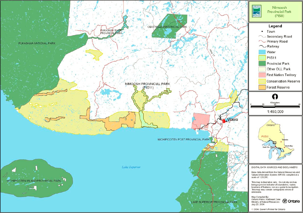
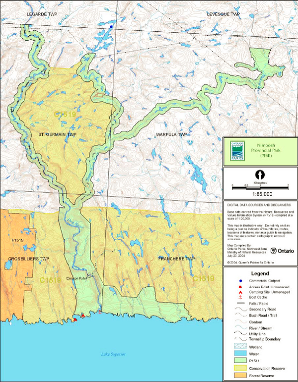
Nimoosh Provincial Park is located 30 kilometres west of Wawa along the Lake Superior coast between Pukaskwa National Park and Lake Superior Provincial Park (see Figure 1). The park is located south of Obatanga Provincial Park within St. Germain, Warpula, Groseilliers, and Francher townships. Nimoosh Provincial Park protects 3,550 hectares of Crown land and includes portions of the Dog River, the Jimmy Kash River, tributary streams to the east, and the Makwa River (see Figure 2).
Nimoosh Provincial Park was designated as a waterway park through Ontario’s Living Legacy Land Use Strategy (OMNR 1999a). Waterway parks are based on outstanding recreational water routes and provide high quality recreational and education experiences (OMNR 1992). The park was regulated under the Provincial Parks Act (1990) in December 2002 (O. Reg. #311/02).
1.1 Objectives
Nimoosh Provincial Park will be managed according to provincial park objectives:
Protection: To protect provincially significant elements of the natural and cultural landscapes of Ontario.
Recreation: To provide provincial park outdoor recreation opportunities ranging from high-intensity day-use to low-intensity wilderness experiences.
Heritage Appreciation: To provide opportunities for exploration and appreciation of the outdoor natural and cultural heritage of Ontario.
Tourism: To provide Ontario’s residents and out-of-province visitors with opportunities to discover and experience the distinctive regions of the Province.
2.0 Management context
This Interim Management Statement (IMS) provides direction for the management and protection of park resources. If required in the future, park management planning may be conducted, which includes public consultation. At that time, direction and significant decisions regarding resources stewardship, operations, development and permitted uses may be made.
Park management will follow direction from:
- Ontario’s Living Legacy Land Use Strategy (OMNR 1999a), policy clarification amendments (OMNR 2000) and related direction
- Ontario Provincial Parks Planning and Management Policies (OMNR 1992) and updates
- Ontario Crown Land Use Policy Atlas (OMNR 2004a) and amendments
- Provincial Parks Act and regulations
In addressing custodial management obligations to protect park values and ensure public health and safety, Ontario Parks will ensure that policy and environmental assessment requirements are implemented.
The park superintendent will implement the policies, procedures and legislation which are derived from the above direction and written into this IMS.
2.1 Environmental Assessment
As part of the Ontario Ministry of Natural Resources (MNR), Ontario Parks is a public sector agency that is subject to the Environmental Assessment Act (1990). Park management will be carried out in accordance with legislation, policies and guidelines that are required under MNR's Class Environmental Assessment for Provincial Parks and Conservation Reserves (2005).
3.0 Park features and values
Nimoosh Provincial Park protects a number of geological, biological, cultural and recreational features and values.
The Dog River Terraces are geological features in the park that represent post- glacial events in the Lake Superior basin. Two areas of biological importance are protected within the park. The Jimmy Kash and Makwa Forest are areas that were identified as candidate life science Areas of Natural and Scientific Interest (ANSI).
Native pictographs are located on vertical rock faces at the mouth of the Dog River.
Nimoosh Provincial Park protects a canoe route on the free-flowing Dog River. This demanding whitewater route in a remote roadless area is recommended for advanced paddlers only.
Figure 1: Regional Setting

Enlarge Figure 1: Regional Setting
Figure 2: Park Boundary
3.1 Geological features
The bedrock of Nimoosh Provincial Park consists of metavolcanic, metasedimentary, and felsic intrusive rocks of the Wawa Subprovince within the Superior Province of the Canadian Precambrian Shield. The metavolcanic and metasedimentary rocks form part of a small greenstone belt, the Mishibishu Lake greenstone belt, which runs from the mouth of the Dog River to the Superior coastline in Pukaskwa National Park (Kor 2002).
The granitic rocks in the area north of the Mishibishu Lake greenstone belt near the park are generally massive to faintly foliated felsic intrusives (Kor 2002).
The bedrock areas of Nimoosh Provincial Park have a thin, discontinuous veneer of stony, sandy glacial till.
The deposit of sand and gravel of the lower valley of the Dog River has been modified by lakeshore processes during high glacial and postglacial lake levels and contains a number of raised terraces that reflect the former levels of these lake stages in the Lake Superior basin. The raised terraces in this area are referred to as the Dog River Terraces and are representative of deposition throughout postglacial time in the Superior basin, from the inception of glacial Lake Minong to the present. Wave-cut erosional terraces representing the major lake level fluctuations during that time are well-developed in the outwash deposits along the lower reaches of the Dog River valley. These terraces are considered to be provincially significant (Kor 2002).
The Dog and Jimmy Kash rivers were likely main drainage ways for melting glacial ice in immediate postglacial times, as evidenced by the boulder lags along the upper valleys. Potholes are common in the bedrock surfaces of these valleys (Kor 2002).
3.2 Biological features
The Dog and Jimmy Kash rivers are free- flowing rivers on the northeast coast of Lake Superior. The intolerant hardwood-coniferous valley forests are similar to those found on the north shore of Michipicoten Island and along the Pukaskwa River in Pukaskwa National Park. Arctic alpine associated species occur on the coast of Lake Superior and are known to occur as far inland as Denison Falls (Morris 2002).
Nimoosh Provincial Park includes the Jimmy Kash and Makwa River Forest candidate life science Areas of Natural and Scientific Interest (ANSI). These areas include open spruce-pine lichen forest, which is a preferred habitat of woodland caribou. These areas are open canopied black spruce-jack pine-lichen woodland that has developed on glaciofluvial sand and gravel of the river valley (Noble 1983).
The park protects an important ecological link between Obatanga Provincial Park and the Lake Superior coast. It also protects potential woodland caribou habitat (Morris 2002; OMNR 2004a).
3.3 Cultural setting
The name of the Dog River on earlier national topographic maps from the 1960s-1980s was the University River. The Michipicoten First Nation, local community interests and MNR Wawa District worked cooperatively to have the name "Dog River," a previous name of Aboriginal heritage, reinstated as the official name for the river in the 1990's. With the recommendation to establish a provincial park in 1994, Wawa district worked with the Michipicoten First Nation to name the park using the Ojibwa name "Nimoosh" which means "dog".
No investigation into cultural features specific to Nimoosh Provincial Park has been completed at this time. There are, however, native pictographs located at the mouth of the Dog River. Any future planning will be within the context of a provincial framework, A Topical Organization of Ontario History (OMNR 1974). In addition, updates and discussions with First Nations, other agencies and stakeholders may be carried out to identify cultural heritage values and features within the park and their significance. This information may be used to develop management guidelines to conserve and protect representative archaeological and historical values and features, or to provide direction for further research.
3.4 Recreation
The Dog River is a primary drainage in the Lake Superior basin. The headwaters of the Dog River are located in Obatanga Provincial Park. Approximately 22 kilometres of the river are included within Nimoosh Provincial Park.
The Dog River is a favourite of white water canoeists, including Bill Mason, noted canoeist, author, filmmaker and painter. Mason’s work popularised canoeing along the Lake Superior coast and throughout Canada.
The route can begin in Obatanga Provincial Park or further down the Dog River at a road crossing north of Nimoosh Provincial Park. This route is navigable by canoe or kayak, with portage trails around the more difficult sections. The portages can be lengthy depending on water levels and paddling skills. This river is recommended for only experienced paddlers as it is remote and offers very technical white-water sections.
One of the Dog River’s highlights is Denison Falls. A two kilometre linear hiking trail at the mouth of the river on the Lake Superior coast travels upstream to the falls.
Since Nimoosh Provincial Park is not easily accessible by means other than canoe or kayak, recreational use of the park is considered low. Other recreation activities that may occur in conjunction with the paddling activity in the waterway park include camping, fishing, hunting, exploring, and general nature appreciation (i.e. nature study and interpretation of natural features) (Kershaw 2002).
4.0 Aboriginal use
Nimoosh Provincial Park lies within the Robinson – Superior Treaty of 1850 and is west of Michipicoten Indian Reserve.
First Nations have expressed interest in and have shared knowledge of the park and surrounding area. Aboriginal communities have used the area for hunting, trapping, fishing, gathering and travel. These uses may continue, subject to public safety, conservation and other considerations.
Any communications and cooperation between Aboriginal communities and the MNR for planning and operations purposes will be done without prejudice to any future discussions or negotiations between the government of Ontario and Aboriginal communities.
5.0 Stewardship policies
5.1 Terrestrial ecosystems
The removal, damage or defacing of Crown property, natural objects, relics and artifacts is not permitted in provincial parks (Provincial Parks Act).
5.1.1 Vegetation
Harvesting
Commercial forest harvesting and renewal activities are not permitted within the park (OMNR 2004a).
The harvest of non-timber forest products such as club moss, Canada yew etc. will not be permitted within the park.
There are no fuelwood cutting permits currently issued for the park. No new permits will be issued (OMNR 2000).
Non-native plants
Non-native plant species will not be deliberately introduced into the park. Where non-native plant species are already established, and threaten park values, a strategy may be developed to control the species (OMNR 1992).
Insects and disease
Insects and diseases may be managed where the park’s aesthetic, cultural or natural values are threatened (OMNR 1992).
Control methods will follow guidelines established by the Ontario Ministry of the Environment (MOE) and MNR. Biological controls, in preference to chemicals, will be used whenever possible (OMNR 1992).
Fire
The park is located within MNR's Boreal Zone for forest fire management. In accordance with existing provincial park policy and the Forest Fire Management Strategy for Ontario, forest fire protection will be carried out in the park as well as on surrounding lands (OMNR 2004b).
Whenever feasible, MNR's Forest Fire Management program will use techniques to minimize damage to the landscape such as limiting the use of heavy equipment or limiting the number of trees felled during response efforts (OMNR 2004b).
5.1.2 Wildlife management
The park is located within Wildlife Management Unit 33. Removal or harassment of non-game animals is not permitted in provincial parks (Provincial Parks Act).
Hunting
Sport hunting is permitted to continue within the boundary of Nimoosh Provincial Park. Considerations of safety and conservation with respect to hunting may be made through future management planning, which includes public consultation (OMNR 2000). The Fish and Wildlife Conservation Act (1997) and the Migratory Birds Convention Act (1994) govern hunting within the park. The Ontario Hunting Regulations Summary contains regulations specific to this area.
The harvest of bullfrogs or snapping turtles is illegal in provincial parks (OMNR 2004c).
Bear Management Areas
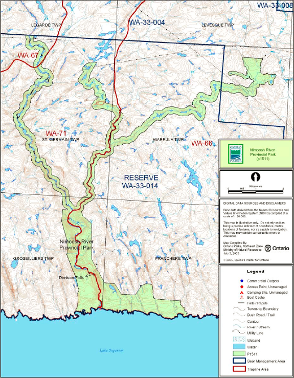
Bear management area (BMA) WA-33-004 overlies the northeast portion of the park and is currently allocated for use. BMA WA-33-014, which overlies the central and southern portions of the park, is currently held in reserve (see Figure 3).
Existing commercial bear hunting operations are permitted to continue. New BMA licences will not be permitted (OMNR 2003). The issuance of licenses to provide bear hunting services will be allowed where areas have been licensed or authorized under agreement for the activity since January 1, 1992. This activity may be subject to conditions identified during future management planning (i.e. the designation of nature reserve zones).
Trapping
There are three trap line areas that overlie the park: WA-71, WA-66, and WA-67 (see Figure 3).
Existing commercial fur harvesting operations may continue indefinitely except in wilderness or nature reserve zones which may be determined through future planning. New operations, including trap cabins and trails, will not be permitted (OMNR 2000).
"Existing use" is defined as use that is supported by an active license, permit or other formal authorization. If this authorization lapses the activity is no longer considered an existing use (OMNR 2000).
Transfers of active trap line licenses are permitted, subject to a review of potential impacts and the normal transfer or renewal conditions that apply.
Figure 3: Trap Line and Bear Management Areas
5.1.3 Industrial resources
There are no licensed aggregate pits (active or inactive) within the boundary of Nimoosh Provincial Park. Aggregate extraction is prohibited in provincial parks (OMNR 1992).
There are no existing mining claims within park. The mining and surface rights on all lands within the park have been withdrawn from staking under the Mining Act (1990). Mineral exploration and mineral extraction are not permitted in provincial parks (OMNR 1992).
5.1.4 Access and crossings
Access
The park is accessible from forest access roads extending south from Highway 17. Two utility corridors may also provide limited access to the northern sections of the park.
Park waters are accessible by canoe. This canoe route is for advanced paddlers only. The mouth of the Dog River and the southern boundary of the park are accessible by water from Lake Superior.
Roads
A forest access road to the north Makwa River portion of the park provides access to the hydro corridor and forest harvest limits adjacent to the park. This road travels south from the Paint Lake Road off of Highway 17. The portion of the road corridor within the park boundary is included in the park land base.
As per direction from the Ontario Forest Accord (OMNR 1999b), one new road crossing of the park for forestry purposes may be permitted.
Where existing forest access roads are essential for continued access beyond the park for forest management or recreation purposes, and alternative road access does not exist, or road relocation is not feasible, existing roads will continue to be available for access. Continued use will include maintenance and may include upgrading (OMNR 2004a). Ontario Parks is not responsible for the maintenance or upgrading of any new or existing roads within the park boundary.
Any proposed development, maintenance or upgrading of existing roads must meet all Environmental Assessment Act requirements.
Utility corridors
There are three utility corridors crossings of the park (Figure 2). These power line corridors are managed through land use permits (LUPs) issued to the owners of the line. The River Gold Mines Limited power transmission line crosses the park twice in St. Germain Township. The Hydro One power transmission line crosses the park in Warpula Township. The corridors of these transmission lines are included in the park boundary.
Maintenance of these existing utility lines will be permitted. These activities must adhere to the regulations set out under the relevant acts, such as the Environmental Assessment Act, the Canadian Environmental Protection Act (1999), and the Pesticides Act (1990). Maintenance activities shall not impact negatively on park values.
All public utilities (e.g. gas pipelines, transmission lines, communications towers, etc.) must avoid park lands wherever possible. New utility corridor crossings may be necessary to maintain essential public services (OMNR 2004a).
Any future utility corridors proposed through the park, where park lands are unavoidable, will be reviewed on a case-by-case basis. Protection of park features and values will be priority and all requirements of the Environmental Assessment Act will be met.
Ontario Parks may provide tenure for a utility corridor to accommodate the development of the new East-West Tie electrical transmission line, subject to completion of an Environmental Assessment, approval by the Minister, and any conditions necessary to protect park values.
Recreational trails
Hiking: There is a two kilometre linear hiking trail that travels from the mouth of the Dog River north to Denison Falls. This trail is accessible only by water from the Lake Superior coast.
Canoe Route: The Dog River is a route for advanced paddlers as it is isolated, rugged, and requires a high level of technical white water and wilderness tripping skills. The route can be started at Obatanga Provincial Park or at an old crossing of Paint Lake Road on the Dog River. From Obatanga Provincial Park the route is approximately 57 kilometres in length. Route length from the Paint Lake Road crossing is approximately 37 kilometres. From the mouth of the Dog River, the route travels 20 kilometres east along the Lake Superior shoreline to the mouth of the Michipicoten River.
Snowmobile Trails: There are no existing designated snowmobile trails the park.
ATV Trails: There are no designated ATV trails in Nimoosh Provincial Park.
5.1.5 Adjacent land management
Forestry
The land adjacent to Nimoosh Provincial Park is within the Wawa Forest management unit. This management unit is currently managed by Clergue Forest Management Incorporated.
Conservation Reserves (CR)
Lake Superior Highlands Conservation Reserve (C1519) is located adjacent to Nimoosh Provincial Park. This CR encompasses 62,122 hectares of Crown land along the Lake Superior coast and areas between the Dog River and Jimmy Kash River portions of Nimoosh Provincial Park. This CR is dominated by moderately broken bedrock with mixed forests.
Adjacent tourism development
With the exception of one outpost camp to the north, there are no known tourism developments adjacent to the park.
5.1.6 Land disposition
There are no existing private recreation camps, cottage lots or patent lands within the park.
No new land disposition for the private use of individuals or corporations will be permitted (OMNR 1992, 2000a).
Land use permits, licenses of occupation, unauthorized occupations
The utility lines that cross the park are managed by land use permits (LUPs). One LUP is issued to River Gold Mines Limited allowing two crossings in St. Germain Township. The other LUP is a province-wide permit issued to Hydro One for their utility line crossing in Warpula Township.
There are no known licenses of occupation within Nimoosh Provincial Park No new land disposition for private recreational use will be permitted (OMNR 1992, 2000a).
New land disposition for commercial use may be considered in the form of land use permit or lease, provided that the proposed commercial use is consistent with conditions of the PPCRA and the project has been approved through an Environmental Assessment process.
There are no known unauthorized occupations within the park.
Boat caches
As stated in the Provincial Parks Act (1990), watercraft are not permitted to be left unattended in the park without written permission from the superintendent.
5.2 Aquatic ecosystems
Sustaining quality water resources is integral to the protection of park and adjacent lands values. The MOE enforces applicable legislation and regulations for water quality.
5.2.1 Water management
There are no existing water control structures within Nimoosh Provincial Park. No new commercial hydroelectric developments will be permitted (OMNR 2000; 2004a).
5.2.2 Fisheries management
Fisheries management activities will be aimed, wherever possible, at the maintenance and enhancement of native, self-sustaining fish populations. Non-native fish species will not deliberately be introduced into park waters (OMNR 1992).
Sport fishing
Sport fishing is permitted within waterway class parks and is governed by legislation and regulations in the Fish and Wildlife Conservation Act and the Fisheries Act (1985). The Recreational Fishing Regulations Summary (OMNR 2004d) contains details on the regulations that are applicable to this area.
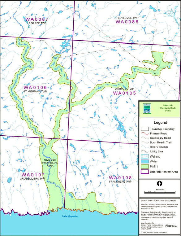
Figure 4: Baitfish Areas
Commercial fishing
There are no commercial fishing operations within the park. New operations will not be permitted (OMNR 2004a).
Commercial baitfish harvesting
There are four vacant baitfish licenses that overlie Nimoosh Provincial Park (WA0105, WA0106, WA0107 and WA0108) (Figure 4).
Existing commercial bait harvesting (active licenses) will be permitted to continue indefinitely in the park, but may be subject to possible conditions identified through future park management planning or MNR district fisheries management plans (OMNR 2000; 2003). New baitfish licenses will not be issued within the park (OMNR 2003).
Fish stocking
The stocking of native fish species may be considered through park management planning, with full public consultation. The stocking of non-native fish species is not permitted (OMNR 2004a).
6.0 Operations policies
6.1 Recreation management
The overall management intent for Nimoosh Provincial Park is to preserve the remote wilderness character of this waterway class park. Priority will be given to non-mechanized recreation such as canoe travel. Future planning may review direction on motorized and non-motorized recreational uses.
6.1.1 Motorized recreation
Motorboats
Due to the rugged white water character of the rivers, motorboat use within the park is limited. Under the general policy for waterway class parks, motorboats are permitted, however their use will be discouraged in Nimoosh Provincial Park to protect the park’s natural character. Any existing use may continue unless park values are threatened (OMNR 2004a).
Snowmobiles
There are no authorized snowmobile trails within the park. Proposals for new snowmobile trails may be considered through future planning with public consultation (OMNR 2000).
Off-trail snowmobile use is prohibited unless authorized by the superintendent under the authority the Provincial Parks Act and consistent with provincial park policy.
All-terrain vehicles
There are no authorized all-terrain vehicle (ATV) trails within the park. Proposals for new ATV trails may only be considered through future planning, with public consultation (OMNR 2000).
Off-road use of ATVs is prohibited unless authorized by the superintendent under the authority the Provincial Parks Act and consistent with provincial park policy.
Aircraft
Opportunities for aircraft landings are limited due to the rugged nature of the park’s watercourses. Aircraft access in waterway parks is limited to specific zones as may be defined through future planning (OMNR 1992). All aircraft landings are subject to regulation and valid aircraft landing permits issued by the park superintendent.
6.1.2 Non-motorized recreation
Camping
There are several unmanaged campsites along the canoe route. Existing use of unmanaged campsites may continue unless park values are threatened (OMNR 2004a).
Ontario Parks may assess the condition of existing campsites and will maintain, rehabilitate or close sites as required. If there is an identified need, new backcountry campsites may be considered (OMNR 2004a). Infrastructure will be permitted in order to protect park features and values in response to use, environmental deterioration and environmental protection requirements. Any proposed development in the park must fulfill the requirements of the Environmental Assessment Act.
Hiking
There is currently one existing hiking trail in the park near the mouth of the Dog River.
Existing use may continue, unless park values are threatened.
If there is an identified need, new hiking trail development may be considered (OMNR 2004a). Trail infrastructure to protect park values and features will be permitted. Any proposed development within the park must fulfill the requirements of the Environmental Assessment Act.
Canoeing/kayaking
Existing uses may continue, unless park values are threatened (OMNR 2004a). Infrastructure to protect park features and values will be permitted.
6.1.3 Emerging recreational uses
There are emerging recreational uses for which there may be limited policy to deal with their management (e.g. adventure racing, geocaching, etc.). The park superintendent will use legislation, policy and guidelines which are already in place to manage emerging uses. These include:
- High Risk Activities by Organized Groups in Provincial Parks
- Special Events in Provincial Parks
- Film Crews in Provincial Parks
- Provincial Parks Act: persons shall not excavate for any purposes; remove, damage or deface Crown property; litter, rappel or rock climb, leave a vehicle unattended; all persons must travel with a permit.
The park superintendent will work with nearby MNR districts to manage these uses.
6.2 Development
There is no existing park infrastructure within the park. Infrastructure to protect park features and values will be permitted and developed in response to use, environmental deterioration and environmental protection requirements. All development must meet the requirements of the Environmental Assessment Act.
6.3 Commercial tourism
Infrastructure for commercial tourism does not exist within the park. New commercial tourism facilities may be considered through future planning, with public consultation (OMNR 1999a). Any proposed development within park boundaries must fulfill the requirements of the Environmental Assessment Act.
7.0 Cultural resources
An assessment of the cultural resources specific to Nimoosh Provincial Park has not been completed at this time. Management of any cultural values within this park will be directed toward protection and heritage appreciation (OMNR 1992).
8.0 Heritage education
Literature and other support information may be developed to describe Nimoosh Provincial Park in the context of Ontario’s provincial park system. Boundary limits, significant heritage features and permitted uses of the waterway park may be included in park literature.
Prospective park visitors may be informed about the sensitivity and significance of park values through park literature.
9.0 Research
Scientific research by qualified individuals that contributes to the knowledge of natural or cultural history, or to environmental or recreational management, will be encouraged in the park. Ontario Parks will encourage institutions, such as universities, to undertake research projects.
All research programs will require the approval of Ontario Parks and are subject to park policy and other applicable legislation. Any materials removed from the park will remain the property of Ontario Parks.
Approved research activities and facilities will be compatible with the park’s protection objective. Any site which is affected by research will be rehabilitated as closely as possible to its original state. Environmental Assessment Act requirements will apply.
10.0 References
Canadian Environmental Protection Act, 1999.
Environmental Assessment Act, 1990.
Fisheries Act, 1985.
Fish and Wildlife Conservation Act, 1997.
Kershaw, W., 2002. Recreation Assessment Dog River, Nimoosh Provincial Park Inventory Report, Version 1.5. Ontario Ministry of Natural Resources.
Kor, P., 1998. Dog River Terraces. Earth Science Checksheet. Ontario Ministry of Natural Resources.
Kor, P., 2002. Earth Science Inventory Checksheet – Nimoosh Provincial Park. Ontario Ministry of Natural Resources.
Migratory Birds Convention Act, 1994.
Mining Act, 1990.
Morris, E., 2002. Natural Heritage Area Live Science Checksheet – Dog River Provincial Park (OLL P1511). Ontario Ministry of Natural Resources.
Noble, T., 1983. Ontario Nature Reserve Program Life Science Inventory Checksheet – Jimmy Kash and Makwa Rivers. Ontario Ministry of Natural Resources.
Ontario Ministry of Natural Resources, 1974. A Topical Organization of Ontario History. Historic Sites Branch Division of Parks.
Ontario Ministry of Natural Resources, 1992. Ontario Provincial Parks Planning and Management Policies.
Ontario Ministry of Natural Resources, 1999a. Ontario’s Living Legacy Land Use Strategy.
Ontario Ministry of Natural Resources, 1999b. Ontario Forest Accord: A Foundation for Progress.
Ontario Ministry of Natural Resources, 2000. Ontario Provincial Park Policy as Amended by the Ontario Living Legacy Land Use Strategy.
Ontario Ministry of Natural Resources, 2003. Directions for Commercial Resource Use Activities in Provincial Parks and Conservation Reserves. 5 pp.
Ontario Ministry of Natural Resources, 2004a. Crown Land Use Policy Atlas.
Ontario Ministry of Natural Resources, 2004b. Forest Fire Management Strategy for Ontario. Aviation and Fire Management Branch.
Ontario Ministry of Natural Resources, 2004c. Hunting Regulations Summary.
Ontario Ministry of Natural Resources, 2004d. Recreational Fishing Regulations Summary.
Ontario Ministry of Natural Resources, 2005. Class Environmental Assessment for Provincial Parks and Conservation Reserves.
Pesticides Act, 1990.
Provincial Parks Act, 1990.
Appendix A: Consultation
In August 2019, this management statement was amended to allow for a hydro line crossing. On February 7, 2017, a policy proposal notice was posted on the Environmental Registry for the review of the proposed amendments. The comment period occurred between February 7, 2017 - March 24, 2017. Letters were also sent to Indigenous communities and other interested or affected stakeholders to notify, and request input, on the proposed amendments to park management direction. As a result of consultation, a total of 3 comments were received. One comment was supportive of the East-West Tie project. Two comments requested more information about the project.
Appendix B: Background information
| Name | Nimoosh Provincial Park (P1511) |
|---|---|
| Classification | Waterway |
| Ecoregion/Ecodistrict | 3E-4 (Tip Top Mountain) |
| OMNR Administrative Region/District | Northeast - Wawa |
| Total Area (ha) | 3,550 |
| Regulation date & Number | December 2002 (O. Reg 311/02) |
Representation
Earth science:
The bedrock of Nimoosh Provincial Park consists of metavolcanic, metasedimentary, and felsic intrusive rocks of the Wawa Subprovince within the Superior Province of the Canadian Precambrian Shield. The Dog and Jimmy Kash rivers were likely main drainage ways for melting glacial ice in immediate postglacial time, as evidenced by the boulder lags along their upper valleys. Potholes are also common to the bedrock surfaces of these valleys.
The bedrock areas of Nimoosh Provincial Park have a thin, discontinuous veneer of stony, sandy glacial till.
Nimoosh Provincial Park also includes the Dog River Terraces. These terraces are provincially significant representations of deposition through postglacial time in the Superior basin, from the inception of Lake Minong to the present.
Life science:
Nimoosh Provincial Park links Obatanga Provincial Park to the Lake Superior coast. The park also includes two areas that were identified as candidate life science Areas of Natural and Scientific Interest (ANSI): the Jimmy Kash and Makwa River Forest. These areas are open canopied black spruce-Jack pine-lichen woodland that has developed on glaciofluvial sands and gravel of the river valley. These areas are preferred habitat for woodland caribou. The vegetation along the Dog River valley consists of intolerant hardwood-coniferous forest. Species at risk occur in the park seasonally (e.g. woodland caribou, bald eagle).
The Dog River provides important spawning areas for lake trout.
Cultural resources:
An investigation and analysis of the cultural resources specific to Nimoosh Provincial Park has not been completed at this time.
Recreation & tourism:
The recreation level of this park is considered to be low. The park is relatively inaccessible with the exception of the Dog River canoe route. This park offers a remote wilderness experience that should only be attempted by those with sufficient skills to handle this type of challenge.
The Dog River canoe route can be started in Obatanga Provincial Park or at another point located downstream on the Dog River. The route travels down the Dog River to the Lake Superior coast. This route offers technical white-water sections and is a demanding paddle.
One of the highlights of the Dog River is Denison Falls which is located at the southern end of the Dog River. There is a linear hiking trail located at the mouth of the Dog River on the Lake Superior coast that travels two kilometres upstream to the falls.
Other recreation use of this park could include fishing, hunting, exploring, nature study, and interpretation of the natural features of the park (e.g. Dog River Terraces).
There are no tourism facilities (i.e. commercial outpost camps) within Nimoosh Provincial Park. Some outfitting businesses in the area incorporate the Denison Falls hiking trail into their sea kayaking trips.
Inventories
| Survey Type | Earth Science | Life Science | Cultural | Recreational |
|---|---|---|---|---|
| Reconnaissance | Kor, 2002 | Noble, 1983; Morris, 2002 | Kershaw, 2002 |
Footnotes
- footnote[1] Back to paragraph Transfers include situations where a license is surrendered with a request that it be immediately reissued to another individual or organization that is assuming an existing operation. Trap cabins are considered part of a trapline and would be transferred with the trapline for the purposes of trapping. If a trapline license is revoked or surrendered, all portions of the registered line within the park will be rescinded from the legal description of the trap line (OMNR 2001).