Obatanga Provincial Park Management Plan
This document provides policy direction for the protection, development and management of Obatanga Provincial Park and its resources.
©1988 Queen’s Printer of Ontario Printed in Ontario, Canada
Single copies of this publication can be obtained from the Ontario
Ministry of Natural Resources, Wawa District Office, P.O. Box 1160, 22
Mission Road, Wawa, Ontario, P05 1K0, telephone 705-856-2396.
Price: $2.00 (Tax Included)
ISBN 0-7729-2090-7
Approval statement
We are pleased to release this management plan for Abating Provincial Park. It is a statement of policy for the protection, management, and development of park resources. It also provides guidance for the preparation of plans for resource management, visitor services, and development to implement park policies and achieve park objectives.
M.A Klugman
Regional Director
Northeastern Region
Norm R. Richards, Director
Parks and Recreational Areas
Branch
1. The park
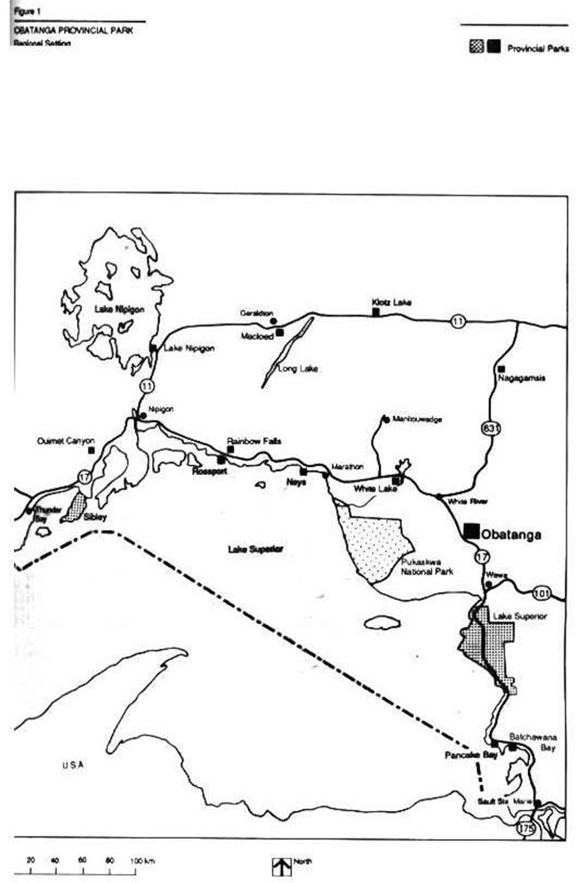
Obatanga Provincial Park is located on Highway 17, 56 kilometres west of Wawa and 37 kilometres east of White River. The park contains 9,413 hectares (Figure 1).
The park was opened in 1962 just after Highway 17 was completed around the north shore of Lake Superior. The park area was put into regulation in 1967 (O. Reg. 245/67).
This natural environment class perk has a landscape that varies from flat sand plains in the northeast to rugged bedrock hills in the south. Lakes and wetlands are scattered throughout the park area.
Park development includes 132 campsites (20 with electrical outlets), an outdoor theatre, a comfort station, and a day use area in a mature stand of Jack Pine on Burnfield Lake.
The majority of the park is an undeveloped area of small lakes, creeks, and Boreal Forest-ideal for canoeing and fishing.
The attraction of the park is its close proximity to Highway 17, modern campground facilities bordering accessible wilderness with natural features such as Jack Pine stands, small lakes, fisheries and a peaceful setting.
2. Classification
Obatanga Provincial Park is classified as a natural environment class park. The park provides a combination of low and high intensity activities in a natural setting. It encompasses significant and representative Boreal and glacial landform features.
3. Goal
The following goal and objectives have been derived from the Ontario Provincial Parks Planning and Management Policies (OMNR, 1978). They will guide park zoning, resource management, visitor services, and development in the park:
"To protect and manage the Obtanga Provincial Park landscape for high quality recreation and heritage appreciation experiences."
4. Objectives
4.1 Protection
The park' s protection objective is:
"To protect provincially significant natural environments incorporating natural and recreational features."
The park area helps meet the provincial representation target of a natural environment park in Site Region 3E/Site District 5. Wetland communities, a chain of lakes suitable for activities like canoeing, a campground situated in a mature Jack Pine stand, and glacial outwash deposits are examples of significant features protected in the park. These features will be protected through appropriate zoning and management.
4.2 Recreation
Obatanga Provincial Park has the following recreation objectives:
"To provide an annual supply of 7,900 day use opportunities in an area of recreational potential associated with natural environments."
Day use opportunities will be provided through a variety of recreational activities and facilities such as a safe swimming and beach area with picnic facilities on Burnfield Lake; boating, canoeing, and fishing on other park lakes; walking trails; and open space play areas.
Figure 1: Obatanga Provincial Park Regional Setting
"To provide an annual supply of 32,200 camping opportunities in natural environments and in associated areas of recreational potential."
Car camping opportunities will be provided in the two campgrounds on Burnfield Lake. The open Jack Pine stand makes an attractive setting for camping. The small size of Burnfield Lake makes it ideal for small boats. Sand beaches have been developed and maintained adjacent to the campgrounds.
"To provide natural environment backcountry travel and camping opportunities."
A canoe route with campsites has been developed that connects the main park lakes (Burnfield, Obatanga, and Knife Lakes). The route is connected to a variety of areas outside the park. The park lakes are on the headwaters of the Dog (university) River- a river that eventually flows to Lake Superior. This river is well known to wilderness canoeists as a rugged and difficult but very scenic river. The park is often used as a staging area for canoe trips down the Dog (University) River.
4.3 Heritage appreciation
The park’s heritage appreciation objective is: "To provide opportunities for exploration and appreciation of the natural and cultural environments."
Park visitors will have the opportunity to learn more about the park on their own through publications like the park leaflet, displays, and the popular Forest Fire Interpretive Trail.
Park staff, through the level of service defined in the Northeastern Region Visitor Services Plan, will provide some interpretive activities such as children' s programs, conducted walks, amphitheater shows, and special events like the Blueberry Fest.
4.4 Tourism
The park’s tourism objective is:
"To provide Ontario residents and out-of-province visitors with opportunities to discover and experience the distinctive regions of the province."
The park provides a convenient place to stop for day use or camping for people travelling along the Trans-Canada Highway along the north shore of Lake Superior.
The park can also be a destination for visitors wanting small lakes, good fishing, and boating in a quiet Boreal Forest setting. During autumn and spring hunting seasons, hunters use Crown land and parkland, and camp in the area.
The 1982 camper survey results show that park campers spent $255,000 within 25 miles of the park.
As discussed under the Marketing section, park staff will continue to work with local and regional tourist associations and other parks to attract more visitors to the area.
5. Zoning
Lands and waters within Obatanga Provincial Park have been zoned so that they may be allocated to their nest appropriate use.
There is an access zone, a development zone, a natural environment zone, and four nature reserve zones (Figure 2). Development and management policies for these zones can be found in Ontario Provincial Parks Planning and Management Policies.
5.1 Access zone (160 hectares)
A linear access zone will serve as a staging area where a minimum of facilities support the use of the undeveloped area of the park southwest of Highway 17.
This 30 metre wide zone follows the Old Camp 1 access road. This road is not currently maintained.
Facilities will serve backcountry visitors' needs and day visitors using this more remote portion of the park for boating, canoeing, fishing, and other low intensity recreational activities.
Development and management will be limited to: roads; visitor control structures; basic day use facilities; and orientation, research, and management facilities.
A small parking area to facilitate backcountry use will be designated between Knife and Obatanga Lakes. No camping will be allowed at this site during the park operating season.
5.2 Development zone (135 hectares)
The development zone contains the facilities and services for intensive day use, car camping, and associated recreational activities.
Development and maintenance will include: roads; visitor control structures; day use facilities; car campgrounds; basic commercial service facilities for visitors; and interpretive, educational, research, and management facilities.
Existing day use and camping areas and any new facilities will be maintained to standards that will encourage natural environment based activities and provide for uncontrolled conditions and relative freedom from intrusions of fellow recreationists.
5.3 Natural environment zone (5,912 hectares)
The natural environment zone includes attractive landscapes where a minimum of development is required to support low intensity recreational activities.
Development will be limited to backcountry campsites, portage trails, necessary signs for route identification, and ancillary facilities that will support low intensity recreational activities.
5.4 Nature reserve zones
Nature reserve zones protect significant earth and life science features.
Development will be limited to trails, necessary signs, minimal interpretive facilities, and temporary facilities for research and management. Portages, trails, and signs necessary for backcountry travel will be permitted.
Figure 2: Obatanga Provincial Park Zoning
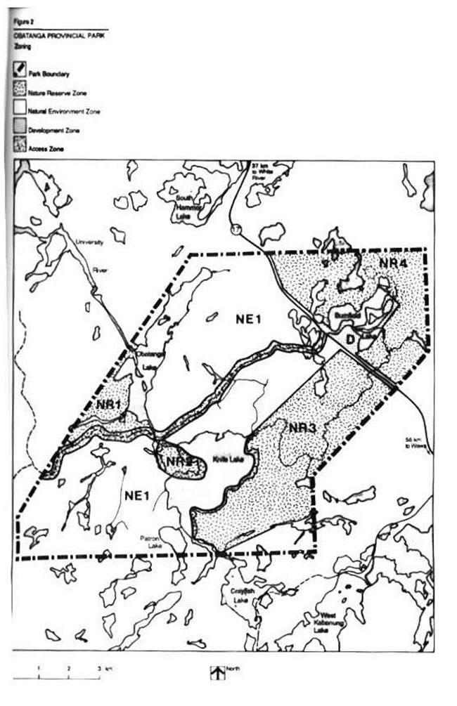
NP 1 Obatanga Lake (312 hectares)
Features of significance here include extensive shoreline and riparian wetlands, and a beaded esker.
NP 2 Knife Lake (76 hectares)
This extensive wetland feature has developed between the existing and previous shorelines of Knife Lake. Along with a variety of wetland features is a sweet gale (Myrica Gale) dominated wetland that may be the best example of this botanical community in the park system within Site Region 3E.
NP 3 Knife Creek (1,495 hectares)
The rugged terrain in the southern portion of this area is associated with the contact zone between granitic intrusives and a belt of metavolcanic and metasedimentary bedrock types. The irregular rounded hills of granitic bedrock support a mosaic pattern of Jack Pine barrens, clumps of pine and deciduous species, and bare patches of bedrock.
To the north of these bedrock barrens is a lowland area associated with Knife Creek. A Jack Pine forest occurs on dry glaciofluvial sands that are an extension of those deposits found in the campground area.
NP 4 Gina Lake (1,323 hectares)
This zone is similar to the north part of NR 3. A Jack Pine forest, a number of clear water hikes, and lowlands are found in this area dominated by glaciofluvial sand and gravel deposits.
6. Resource management
The park will be managed in accordance with the general planning and management policies for natural environment class provincial parks.
Although the following policies for water, vegetation, fisheries, and wildlife are presented separately, all planning and management will recognize that the components are interrelated.
The park operating plan will be updated as a result of ongoing resource management planning.
6.1 Water
Water quality will be tested in accordance with the Ontario Ministry of Natural Resources procedures. This will protect park visitors from hazards associated with unmonitored contaminated drinking or bathing waters.
6.2 Vegetation
Vegetation in the park will be managed to fulfill both protection and recreational objectives. There will be no commercial forest use within the park.
Management guidelines will be derived from management policies for natural environment parks.
The campgrounds appeal to park visitors because of the presence of mature Jack Pine. A vegetation management plan will be prepared for this development zone in accordance with the following principles:
- promote regeneration
- create suitable buffer between campsites
- remove hazardous trees; and
- rehabilitate areas lacking in natural growth
Park staff will contribute to the development of the fire management plan for the Northeastern Region to ensure that park objectives are met.
6.3 Fisheries
Almost one half of all park visitors go fishing when staying in Obatanga Provincial Park. More than a dozen lakes are easily accessible for walleye, brook trout, and northern pike fishing.
The quality of sport fishing is important to the park visitors' experience. A fisheries management plan for Wawa District will be prepared. The plan will include Abating Provincial Park and will also detail stocking requirements and guidelines for the management of native fish populations in lakes of the park.
6.4 Wildlife
Opportunities for the viewing of wildlife will be encouraged. For example, wetland viewing blinds could be built south of the causeway on Burnfield Lake where there is a tendency for sightings of wildlife (e.g. beaver, moose, heron).
Hunting has been a regulated use and will continue to be allowed in all parklands southwest of Highway 17. The delayed opening of the fall hunting season and the early closing of the spring hunting season will be continued in order to minimize conflicts between hunters and other park visitors.
Travel by hunters through the park access zone will be permitted during the hunting season.
Commercial trapping is not allowed in natural environment class provincial parks. As such, existing traplines will be phased out in a manner least harmful to the trappers. New traplines and trappers will be reintroduced.
Beavers, which occasionally cause park management problems by blocking water drainage and thus affecting park operations, will be removed.
7. Visitor services
The visitor services program will provide visitors with an opportunity to gain an understanding, awareness, and appreciation of Obatanga Provincial Park and its objectives, policies, and heritage. This will be achieved through the policies for the following components:
- information
- interpretation
- outdoor recreation
- research
- marketing, and
- backcountry recreation
Park visitor services planning will guide the best combination of these components to deliver this aspect of park operations.
7.1 Information
Information concerning park resource management, facilities, programs, and nearby points of interest will be available at key points throughout the park (park gatehouse, comfort station, etc.). Information will be made available in the form of the park leaflet, information displays, special publications as required, and through informed park staff.
7.2 Interpretation
The park interpretive program will create a greater awareness of natural and cultural values within the park’s overall theme of "Boreal Wilderness" and consists of the following sub-themes:
- the Boreal Forest - fire, wetlands, and animals
- glaciation and the Canadian Shield; transportation-historic difficulties with travel
- outdoor adventure - canoeing, fishing, and
- blueberry picking; and,
- park resource management
Interpretive programs will include both self-use facilities and staff-led activities. Self-use facilities such as the Forest Fire Trail and Guide, and displays at the gatehouse and the visitor centre will continue. Amphitheatre programs through staff-led and guest speakers will also continue.
7.3 Outdoor recreation
Outdoor recreation programming will provide information concerning water-related activities such as canoeing, fishing, and water safety. Backcountry travel ethics such as low impact camping will be presented to the public. Park development arid resource management projects will also be presented to the public.
7.4 Research
Research related to resource management will be encouraged.
All research activity will follow the policies for research in provincial parks.
7.5 Marketing
The park marketing plan will be updated to reflect new initiatives described in this section.
Campers find the park a convenient place to stop on their annual vacation. Only 12.2% of the campers make Obtanga their main destination.
Like other provincial parks on the Trans-Canada Highway along Lake Superior, at least 90% of the visitors are on a vacation trip. Vacation traffic on Highway 17 has been decreasing as determined from a review of highway traffic volume trends. However, tourist attractions have developed, and more are being planned so that this Superior country will become more of a destination area for vacation travelers.
The main park market will continue to be the Highway 17 traveler. Park staff will continue cooperative marketing with regional travel organizations promoting a series of attractions and services from Sault Ste. Marie to Thunder Bay. This will reinforce the tendency for this tourist region to continue to be a destination area and draw on travelers looking to visit several destinations along Highway 17.
The park’s overall theme of "Boreal Wilderness" will be promoted in travel publications. This would give Obatanga a separate identity from other parks along Highway 17.
A secondary market will be backcountry recreationists who could make Obatanga a destination to enter "accessible wilderness". Fishermen, novice wilderness canoeists, and hunters will use the southwest side of the park and adjacent lands. Backcountry camping will accommodate some of these visitors. Others will stay in the park’s campground or adjacent private facilities and visit this area on day trips.
Figure 3: Obatanga Provincial Park Proposed Development
7.6 Backcountry recreation
The large portion of the park area outside of the campground will be available for day use and overnight backcountry travel.
Portages and roads will be available to access the park interior. For example, canoeists can access Gina Lake by portage from Burnfield Lake. Day trips into Knife and Patron lakes can be started from the Kabenung Lake Road south of the park.
Extended overnight backcountry trips can be based from interior campsites or by following the Obatanga Canoe Route. Canoe trips down the Dog (University) River can be started from the park.
This "accessible wilderness" complements the wilderness recreational opportunities in Pukaskwa National Park and Lake Superior Provincial Park by providing visitors to Obatanga with the option of day trips or overnight trips into a less remote area by comparison. This would be ideal for outdoor recreationists short of vacation time or for those who lack the experience for longer backcountry trips.
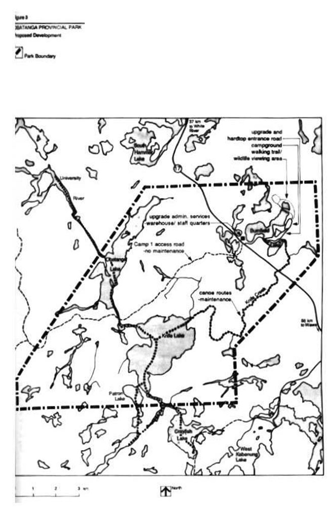
8. Development
All development within Obatanga Provincial Park will reflect the standards for a natural environment class park (Figure 3). Development projects will be proposed through work program planning and special funding initiatives. All development will be carried out in accordance with approved site and development plans. Once development takes place, it will be managed according to the park-operating plan. Requirements of the Environmental Assessment Act will be met.
8.1 Car camping use
Present trends in car camping use indicate that there is no need for additional car camping development. Existing facilities will be upgraded as required.
To reduce dust and maintenance problems, the main park road to the campgrounds will be hardtopped.
8.2 Day use
Existing use in the Burnfield Lake day use area for parking, swimming, picnicking, boat launching, and washroom facilities will be monitored to ensure that use does not cause site deterioration.
Facilities and services will be upgraded as required.
8.3 Backcountry use
To maintain an "accessible wilderness" character, development will be limited to gravel roads, staging areas, portages, trails, campsites, and signs necessary for route identification.
The park area southwest of Highway 17 will continue to be accessed via entry points outside the park:
- Hammer Lake
- Alice Creek
- Kabenung Lake Road; and
- Old Camp 1 Road
The Old Camp 1 Road is not presently maintained (see Section 5.1). A gravel surface for recreational access will be provided as funds and priorities permit for access to this portion of the park.
Additional backcountry campsites will be developed if required. Backcountry camping will not be allowed on access roads during the operating season.
8.4 Office and maintenance centre
In order to maintain the existing level of service and improve park operation (e.g. traffic flows, safety of visitors), a new maintenance building, storage area, gas and oil storage, and park office is needed. A suitable alternate location for this complex will be developed through site planning to separate it from the existing staff accommodation area.
The staff accommodation facilities are also in need of replacement. The existing trailers will be replaced by a 10 person staff house with cooking facilities.
9. Plan implementation and review
The recommended phasing of development will be implemented with approval of the management plan. Annual work program planning will implement all phase one items over the course of this management plan. The phase two projects will be implemented through additional funding proposals. The park operating plan will reflect work program planning decisions and new development needs as they are implemented.
9.1 Implementation priorities
The park operating plan will be updated as needed to reflect projects that have been implemented from the two phases.
Phase one- Work program planning
Resource Management:
- prepare a vegetation management plan for the development zone; and
- park staff will provide input to the fisheries management plan for Wawa District
Visitor Services:
- prepare a visitor services plan
- update the park’s marketing plan; and
- monitor backcountry recreational use on lakes in the park to determine future campsite development/ management needs
Phase Two- Additional funding proposals
Site and Development Planning:
- provide an upgraded park office and maintenance area away from campground and staff accommodation developments following an approved site development plan
- within the development zone, provide a 10 person staff house following an approved site development plan
- upgrade and hardtop the main park road following an approved site development plan
- upgrade walking trails and wildlife viewing opportunities; and
- upgrade and maintain a gravel road for backcountry access along Camp 1 Road southwest of Hwy. 17 within the park
9.2 Plan review
The policies herein have been designed to manage park resources and maintain program services for the next 20 years.
This park management plan will be reviewed on an ongoing basis to monitor the effectiveness and adequacy of its contents.
If changes to the policies herein are needed at any time, the significance of changes will be evaluated; and if necessary, the plan will be reviewed with the public prior to formal amendment.
10. Public consultation
This park management plan is a result of a continuing consultation process that has considered the needs, desires, and opinions of a variety of interests.
Public involvement in the plan began during the spring of 1986 with news releases requesting public input. Background information was available in August and September of 1986 at the park and the Wawa District Office. Copies of the preliminary management plan were mailed directly to interest groups, other government ministries, and adjacent property owners. They were requested to submit, within 30 days, any comments regarding the plan to the District Manager in Wawa. Copies of all comments received are available for viewing at the Wawa District Office.
In applying this park management plan, the Ontario Ministry of Natural Resources is committed to continuing this consultation with government agencies, other ministries, interest groups, and the public. It is important that the channels of communication ion that have been created by this consultation process be kept open.
Selected references
Kor, P. S. G., Earth Science Inventory Checksheet Obatanga Provincial Park, 1977.
Noble, T., Life Science Report for the Central Boreal Forest Region (3E), 1982.
Ontario Ministry of Natural Resources, Wawa District Land Use Guidelines, 1983.
Provincial Park Day User Survey Summary Statistical Report, 1982.
Provincial Park Car Camper Survey Summary Statistical Report, 1982.
Obatanga Provincial Park Marketing Plan, 1980.
Northeastern Region Visitor Services Plan, 1988.