O'Donnell Point Provincial Park Management Plan
This document provides policy direction for the protection, development and management of O'Donnell Point Provincial Park and its resources.
MNR 52073
ISBN 978-1-4249-3443-0 (Print)
ISBN 978-1-4249-3444-7 (PDF)
© 2007 Queen’s Printer of Ontario
Additional copies of this publication can be obtained from:
Park Superintendent
Oastler Lake Provincial Park
380 Oastler Park Drive, RR #2
Parry Sound, ON P2A 2W8
I am pleased to approve the O'Donnell Point Park Management Plan as the official policy for the protection and management of O'Donnell Point Provincial Park. The plan reflects the Ministry of Natural Resources' and Ontario Parks' intent to protect the natural features of O'Donnell Point Provincial Park and maintain and develop high quality opportunities for natural heritage appreciation for the residents of Ontario and visitors to the province.
The plan contains proposed policies relating to resource stewardship, operations and development that will guide the management of O'Donnell Point Provincial Park over the next 20 years. It may be reviewed to address changing issues or conditions.
The plan also includes an implementation strategy and a summary of the public consultation that occurred as part of the planning process.
I wish to extend my sincere thanks to all those who participated in this important process.
Yours truly,
Signed by:
Adair Ireland-Smith
Managing Director
Ontario Parks
Statement of Environmental Values
The Ministry of Natural Resources' Statement of Environmental Values (SEV) was prepared in accordance with the Environmental Bill of Rights (EBR). It describes how the purposes of the EBR are to be considered whenever decisions are made which might significantly affect the environment.
The primary purpose of the EBR is to protect, conserve and, where reasonable, restore the integrity of the environment. From the Ministry’s perspective, that broad statement of purpose translates into four objectives in its SEV:
- To ensure the long-term health of ecosystems by protecting and conserving our valuable soil, aquatic resources, forest and wildlife resources as well as their biological foundations
- To ensure the continuing availability of natural resources for the long-term benefit of the people of Ontario
- To protect natural heritage and biological features of provincial significance; and
- To protect human life, the resource base and physical property from the threats of forest fires, floods and erosion
The Ministry’s SEV has been considered during the preparation of this park management plan. The O'Donnell Point Park Management Plan is intended to reflect the direction set in the SEV and to further the objectives of managing Ontario’s resources on an ecologically sustainable basis.
1.0 Introduction
O'Donnell Point Provincial Park is an 875 ha nature reserve class park, located on a peninsula along the eastern shoreline of Georgian Bay, 50 km south of Parry Sound and 27 km north of Port Severn (Figure 1). The park was regulated under the Provincial Parks Act in 1985 (O. Reg. 81/85 Schedule 176, Appendix B). An interim management statement, approved in 1999, provided management direction for the park.
O'Donnell Point Park is in Ecodistrict 5E-7, the Georgian Bay Littoral Biosphere Reserve, and the Great Lakes Heritage Coast. The park contains biological features of national and provincial significance, and provincially significant examples of earth science features. The park area has 473 varieties of vascular plants, of which 34 are considered to be provincially or regionally significant (i.e. provincially rare species, species at risk and Atlantic Coastal Plain species); 95 species of birds found to date; and 31 known species of reptiles and amphibians, of which 10 are listed as species at risk (i.e. endangered, threatened, or special concern).
The park lies in the Grenville Province of the Canadian Precambrian Shield. This rocky point is dominated by low ridges of Go Home Domain gneissic rocks of the Central Gneiss Belt. The most outstanding feature of the park is its wide variety of wetlands.
There are no visitor facilities. Camping is prohibited and recreational day-use for walking and nature appreciation is discouraged due to the sensitivity of the park’s natural values.
Lands immediately adjacent to the eastern boundaries of O'Donnell Point (i.e. lots 50 to 53 in concession 7) receive protection under Moose Deer Point First Nation’s Land Use Plan (2004) as environmental protection and nature interpretation zones. Private property and several islands, some which comprise part of Georgian Bay Islands National Park, lie adjacent to the park.
This approved park management plan was developed following the policies and guidelines in the Ontario Provincial Parks Planning and Management Policies (1992), Ontario’s Living Legacy Land Use Strategy (1999) and the Provincial Park Management Planning Manual (1994). This management plan for O'Donnell Point will be the official policy for the protection, development and management of the park over the next 20 years. In accordance with this plan, the Ontario Ministry of Natural Resources (MNR) will amend the affected area-specific land use policies and mapping found in the Crown Land Use Policy Atlas.
2.0 Classification
Ontario’s provincial parks are classified into six categories which define an individual park’s contributions to the park system. O'Donnell Point Provincial Park is a nature reserve class park.
Nature reserve class parks are areas selected to represent the distinctive natural communities and landforms of the province. They are protected for educational and research purposes and for their intrinsic values. Permitted activities and management practices are directed solely toward the achievement of protection and heritage appreciation objectives as outlined in policy and objectives of the provincial parks system.
O'Donnell Point’s designation as a nature reserve class park recognizes the park’s undeveloped Georgian Bay shoreline with coastal bedrock; upland and lowland forests; wetlands; and its 31 species of reptiles and amphibians, some of which are near the northern limit of their range.
3.0 Goal
The goal of O'Donnell Point Provincial Park is:
To protect the provincially significant natural heritage of the park and to provide educational and research opportunities to benefit future and present generations.
Figure 1: Regional Context, O'Donnell Point Provincial Park
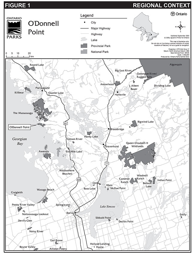
Enlarge Figure 1: Regional Context, O'Donnell Point Provincial Park
In fulfilling this goal, the park contributes to the achievement of protection targets for the provincial park system.
4.0 Objectives
There are four distinct objectives that provide specific direction for the management of Ontario’s park system: protection, recreation, heritage appreciation and tourism. As a nature reserve class park, O'Donnell Point contributes primarily to the protection and heritage appreciation objectives.
4.1 Protection
To protect the significant elements of the natural and cultural landscape of O'Donnell Point Provincial Park.
The park provides excellent representation of the gneissic units of Pine Island Migmatites, part of the Upper Go Home Domain of the Grenville Province. Due to the relatively undisturbed condition of the area, this representation is considered to be provincially significant. This area is also representative of the Grenville Province Supergroup basement rocks within the environmental theme known as Helikian Grenvillian Island Arcs, Sedimentary Basins, and Continental Drift Environment.
The mineral exploration potential of the area is minimal and there is no identified potential for the occurrence of economic concentrations of gold or base metals. There are no active mineral claims in the area and the park is entirely withdrawn from mineral exploration.
The geology and soils of the region have given rise to a variety of plant community types and species within the park that are representative of the Georgian Bay shoreline, broken bedrock uplands, transition forests and wetlands found throughout Ecodistrict 5E-7.
O'Donnell Point occupies a rocky peninsula in Georgian Bay, dominated by a series of parallel bedrock ridges that are thinly vegetated by many poor fens, swamps and beaver ponds in the lowlands. The shore is dominated by barren, windswept rock that is characteristic of eastern Georgian Bay, with occasional small sandy beaches. Its undisturbed mature upland and lowland forest, shrubby bedrock openings and many small wetlands of different types contain a remarkable diversity of flora, reptile and amphibian species.
Approximately 473 species of vascular plants have been documented in the area, including two species with Atlantic Coastal Plain affinities and at least 10 provincially significant vascular plants. The Atlantic Coastal Plain species are of interest because of their disjunct distribution on Georgian Bay. These species are particularly sensitive to shoreline recreation activities. The vegetation of the park is in excellent condition, with relatively few non-native species. Extensive peatland complexes in and adjacent to the park provide habitat for several significant species of vascular plants.
At least 31 species of amphibians and reptiles have been found in the park, of which 10 are classified as species at risk in Ontario. This makes this park one of the most significant protected areas in Ontario in terms of reptiles and amphibian richness.
Nearly 100 species of birds have been documented in the park and suitable breeding habitat for many species is also present. The provincially rare Prairie Warbler has been observed within the park. O'Donnell Point is adjacent to The Massasauga Provincial Park which contains the largest concentration of breeding pairs in Canada. In addition, 17 species of mammals are known to inhabit the area, including black bear, fisher, river otter, and the Eastern wolf, which has been deemed special concern nationally and provincially.
4.2 Heritage appreciation
To provide opportunities for appreciation of the natural heritage of O'Donnell Point Provincial Park.
Considering the region’s natural features and history, a number of interpretive themes have been identified for the park. These include the ecology and geology of the Canadian Shield and the Georgian Bay shoreline, and species at risk. Off-site structured opportunities may be provided to allow park visitors to explore these themes (Section 9.1). On-site exploration will be discouraged.
5.0 Boundary
O'Donnell Point Provincial Park was regulated under the Provincial Parks Act in 1985, and is currently described in Ontario Regulation 81/85 schedule 176 Appendix B. The area of the park is 875 ha (Figure 2). There is a proposed disposition of and addition to the park.
In 2001, the Moose Deer Point First Nation (MDPFN) requested the disposition of a portion of the nature reserve park for addition to MDPFN reserve to help address social, economic and land use planning concerns associated with their disjointed land base. Currently, the three parcels of Moose Deer Point’s Reserve lands are separated by the park.
Three alternatives for disposition were evaluated in the Supplement to the Final Environmental Study Report for O'Donnell Point (2006). MNR's preferred option is the disposition of 160 ha of O'Donnell Point Provincial Park along Twelve Mile Bay (not including the 20 m shore road allowance) and 103 ha of Crown land abutting the east boundary of the eastern most parcel of the three First Nation reserve lands. A separate 180 ha parcel of Crown land located east of the current First Nation’s Addition to Reserve would be added to O'Donnell Point Provincial Park. Once the new boundary is regulated the area of the park will consist of 895 ha, an increase of 20 ha. This management plan re-confirms Ontario Parks' interest in amending the regulated boundary of the park.
The supplement document fulfilled part of the public consultation requirements for amendments to MNR land use direction. As a supplement to the Final ESR, it also addressed the Environmental Assessment Act requirements as set out in Exemption Order MNR-59/2 and Exemption Order MNR-26/7 under the transition provisions of the Class Environmental Assessment for MNR Resource Stewardship and Facility Development Projects and A Class Environmental Assessment for Provincial Parks and Conservation Reserves, respectively.
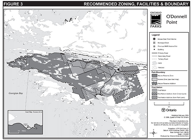
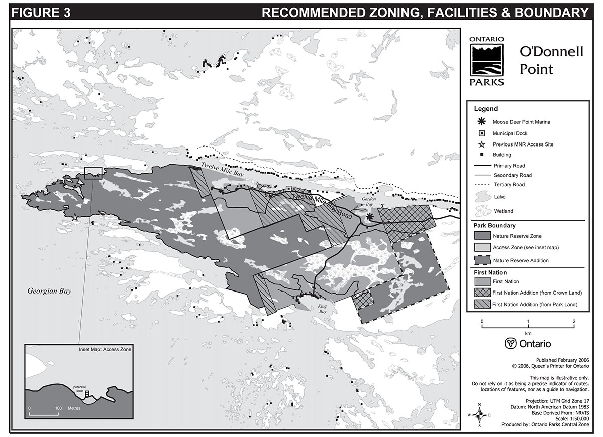
6.0 Zoning
Nature Reserve class parks may contain three possible land use zones: access, nature reserve and historical. Each zone permits certain land uses and outlines park managemement strategies. Zoning will help ensure the park’s goal and objectives are met. The two types of zones that will guide the management and development of the park are access and nature reserve (Figure 3).
6.1 Nature reserve zone
Nature reserve zones provide the highest level of protection. Development within this zone is generally restricted to necessary signs and temporary facilities for research and management.
The 894 ha nature reserve zone, which encompasses most of the park area, will protect the significant natural features of the park. The representation of the gneissic units of Pine Island Migmatites, part of the Upper Go Home Domain of the Grenville Province is considered to be provincially significant. The barren, windswept shoreline and occasional small sandy beaches are characteristic of eastern Georgian Bay. The park’s undisturbed mature upland and lowland forest, many peatlands, swamps and beaver ponds, shrubby bedrock openings and variety of small wetlands contain a remarkable diversity of flora and reptiles and amphibian species. Sixteen species in the park are ranked as S1(extremely rare in Ontario), S2 (very rare in Ontario), and S3 (rare to uncommon in Ontario) by the Ontario Natural Heritage Information Centre. Over 60% of Ontario’s amphibian and reptile species have been recorded in the park.
Figure 2: Existing Boundary, O'Donnell Point Provincial Park
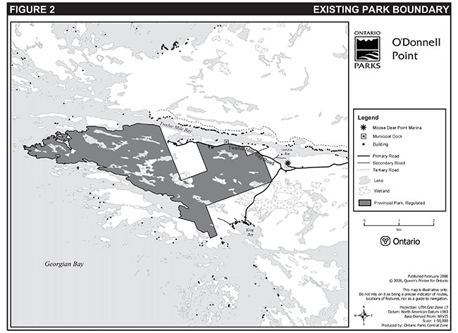
Enlarge Figure 2: Existing Boundary, O'Donnell Point Provincial Park
Figure 3: Recommended Zoning, Facilities & Boundary, O'Donnell Point Provincial Park
Enlarge Figure 3: Recommended Zoning, Facilities & Boundary, O'Donnell Point Provincial Park
6.2 Access zone
One access zone will serve as a rest area where minimal facilities will be established. The access zone will include a small floating dock and may include visitor control structures, and appropriate signage (Section 10.0).
The approximately 0.1 ha access zone is located approximately 1,600 m from the western tip of the park on the north shore. The access zone is situated on barren rock.
7.0 Resource stewardship policies
O'Donnell Point will be managed in accordance with the nature reserve class policies as set out in the Ontario Provincial Parks: Planning and Management Policies (1992), Ontario’s Living Legacy Land Use Strategy (1999), A Class Environmental Assessment for Provincial Parks and Conservation Reserves, and the approved park management plan. Resource stewardship initiatives may be accomplished through partnerships and sponsorships. A resource stewardship plan may be prepared to provide specific prescriptions for the proper stewardship and management of park resources.
Recommendations received from the O'Donnell Point Ecosystem Protection Group will be considered in managing the park. The group is an advisory body comprised of various stakeholders (e.g. cottagers, First Nation, and government), which supports the conservation and stewardship of habitats and processes of the O'Donnell Point ecosystem, and provides a discussion forum related to ecosystem health.
Species at risk recovery strategies and implementation plans may be prepared in the future by a recovery team for species found in the park (e.g. Eastern hog-nosed snake, Eastern fox snake and branched bartonia) A recovery strategy sets out recovery goals, objectives and methods; and recovery implementation plans provides specific details for implementing the strategy.
Recommendations from recovery strategies or implementation plans may be implemented if addressed in a resource stewardship plan or vegetation management plan.
The Crown Land Use Policy Atlas (CLUPA) is MNR's repository of existing local land use policies for Crown lands in the central part of Ontario, including provincial parks. Amendments to the park’s policy report and maps on the CLUPA will be completed to reflect the direction of this park management plan.
Although the policies herein are presented in separate categories, planning and management recognizes that the components are interrelated and that operations, management and protection will ensure that overall park objectives are achieved.
7.1 Land and water management
The significant landforms occurring within O'Donnell Point may be periodically monitored to ensure their continued undisturbed existence. As many of these features are sensitive to disturbance, access to these areas will be discouraged, and may be done through appropriate signage.
Water control structures will not be allowed in the park.
Appropriate mitigation measures will be taken to ensure that all activities occurring within the park do not have a negative impact on water quality within or immediately outside the park.
Entry into the surrounding nature reserve zone will be discouraged and may be restricted through the use of signage or by means of delineation (e.g. fencing).
The use of this zone and any impact on the adjacent nature reserve zone will be periodically monitored.
7.2 Fisheries management
Fishing in Ontario is regulated by the federal Fisheries Act and provincial Fish and Wildlife Conservation Act. These regulations apply to O'Donnell Point. Sport fishing within the park boundaries will not be encouraged to avoid potential negative impacts associated with access for fishing purposes. Information on regulations, conservation, exotic species, and safe fishing and boating practices may be made available in the access zone.
Commercial fishing and bait fishing are prohibited in O'Donnell Point.
Fish habitat management may be undertaken in the park.
7.3 Wildlife management
Wildlife management will be directed to the maintenance of evolving natural succession, unless alternative strategies are desirable. Adaptive management strategies may be addressed in a future resource stewardship plan, especially for provincially and regionally significant species such as species at risk.
Hunting and commercial trapping are not permitted in O'Donnell Point Park. The collection of plants and animals, including amphibians and reptiles is also prohibited. On occasion, the presence or behaviour of animals may conflict with park management objectives. The control of nuisance animals will be carried out as required and according to provincial policies and regulations.
Species inventories and research will be encouraged and pursued as opportunities arise. Significant species may be periodically monitored to document their continued existence within the park.
7.4 Vegetation management
Vegetation in the park will be managed in keeping with natural vegetation succession processes. Missing native species may be re-established if biologically feasible and acceptable and if compatible with the values for which the park was established. All significant species may be periodically monitored to document their continued existence.
Control of invasive and non-native species may be implemented. Insect and disease infestations which threaten the park’s vegetation communities may also be controlled in accordance with provincial policies. Chemical control will only occur where no other means of control is feasible.
Large scale efforts to control non-native and invasive species, or rehabilitate or alter vegetation communities will require the preparation of a detailed vegetation management plan. Further inventory and study will be encouraged and pursued as opportunities arise.
7.5 Forest fire management
O'Donnell Point is located in the Great Lakes/St. Lawrence Fire Management Zone under the Forest Fire Management Strategy for Ontario (2004).
Because of the natural values of the park, and the degree of structural development adjacent to the park, all fires will be suppressed. Response to forest fires in the park will be guided by the municipal forest fire management agreement between the Ministry of Natural Resources and the Township of Georgian Bay. "Light on the Land" response techniques will be used whenever feasible. These minimum impact suppression techniques do not excessively disturb natural or cultural values. Examples may include limiting the use of heavy equipment or the felling of trees during fire response.
Fires for cooking and warmth will not be permitted in the park.
The use of fire through prescribed burning may be considered to achieve ecological or hazard reduction objectives. Plans for any prescribed burns will be developed in accordance with the Prescribed Burn Planning Manual (1997), and applicable policies and legislation.
7.6 Cultural resources
A stage 1 cultural heritage assessment was conducted for O'Donnell Point in 2001. No cultural resources within the park were identified during the assessment. However, the potential for the existence of cultural resources is high for some areas of the park. Cultural heritage guidelines in accordance with the Class Environmental Assessment for Provincial Parks and Conservation Reserves will be followed.
8.0 Operations policies
Operational policies deal with topics such as natural heritage education, recreation management, and research. O'Donnell Point will be managed as a non-operating park.
8.1 Natural Heritage Education
The purpose of Natural Heritage Education for this park is to educate potential and actual visitors about the sensitivity of the resources present so that they can be appreciated without being disrupted. On site exploration will be actively discouraged.
8.1.1 Information
Opportunities to learn about the natural environment of O'Donnell Point may be provided through off-site information and interpretation.
Interpretive information for the park will be low profile and designed for low intensity, self use. An information leaflet may be developed containing information on the sensitivity of the site and its unique biotic and abiotic communities.
Off-site programming may be used in an effort to educate people about the sensitivity of the park’s natural features to human disturbance.
8.2 Recreation management
Recreational use in O'Donnell Point will be actively discouraged. Recreation will be limited to low intensity day-use activities. This may include limited walking, painting, photography, backcountry cross-country skiing and nature appreciation. No trails will be developed.
Activities not permitted in the park include shoreline boat mooring, camping, open fires, scuba and skin diving, all-terrain-vehicle (ATV) use, snowmobiling and hunting.
The access zone may be monitored for erosion and degradation, and may be temporarily closed for rehabilitation as required. Closures and rehabilitation will comply with Ontario Parks standards and guidelines governing capital development.
Permanent signs may be erected to indicate which activities are not permitted. Additional regulatory signs and fencing may be erected as necessary.
All domestic pets must be on a leash. Owners will be required to 'stoop and scoop'.
Geocaching and high risk activities such as adventure racing will be prohibited in order to protect the park’s values. Geocaching is defined as an outdoor activity in which participants use a global positioning system (GPS) to find a predetermined location. Adventure racing is defined as a multi-sport team racing challenge.
Any activity found to have significant adverse effects on the park’s natural features will be controlled. Appropriate actions might include temporary or complete suspension of an activity, spatial relocation, mitigation and rehabilitation.
Information may be provided at the access zone to anglers and boaters to promote responsible practices.
8.3 Research
Research by qualified individuals and groups will be encouraged. All research must be approved and conducted in accordance with provincial park policy on research activities in parks and the Central Zone Research and Information Strategy (2004).
Records will be kept of all research occurring in the nature reserve park. Any samples taken from the park are to remain the property of the Crown and will be archived appropriately.
These samples may be made available to other qualified researchers where appropriate.
9.0 Development policies
As a nature reserve class park, development will be limited to the access zone. Decisions regarding development will consider research and information on the park’s valued features. Development will be carried out in accordance with approved site plans, utilizing appropriate standards, and in conformity with the cultural heritage guidelines in accordance with the Class Environmental Assessment for Provincial Parks and Conservation Reserves and relevant legislation and policy.
Unnecessary undirected light pollution will not be allowed in any future development. Outdoor lighting, if necessary, will be limited to basic safety requirements and will be shielded when possible. This commitment recognizes the natural values provided by a pristine night sky.
9.1 Access
Limited access will only be provided at the designated access point on the northern side of the peninsula in a sheltered bay locally known as Whanee Bay, southeast of Bowes Island approximately 1,600 m from the western tip (Figure 3). The access zone will serve as a limited landing site.
No major facilities will be available. A small floating dock will be erected to facilitate docking at the access zone.
Overnight mooring or camping is prohibited.
Aircraft landings within the park will not be permitted except in emergencies or with prior permission from the superintendent.
Depending on use, the access zone may be fenced.
9.2 Interpretive facilities
There will be limited interpretive facilities provided within O'Donnell Point. Interpretive facilities will be restricted to signage, interpretive panels and/or leaflets within the access zone only. An interpretive panel describing the significant features and their sensitivity to disturbance may be erected in the access zone.
9.3 Research facilities
No permanent research or management facilities will be permitted within the park. Temporary facilities may be erected with the superintendent’s permission. Clearing of vegetation will not be permitted. Any such facility should not disturb the area’s environment and must be removed upon completion of the research.
9.4 Operational and maintenance facilities
There will be no maintenance facilities provided within O'Donnell Point.
Custodial management of the access zone will be through Ontario Parks staff. However, Ontario Parks may enter into partnerships with non-government organizations, volunteers or others regarding custodial management.
Custodial management may include floating dock maintenance, and garbage pick-up. The use of this zone and any impact on the adjacent nature reserve zone may also be periodically monitored.
10.0 Implementation strategy
The resource stewardship activities and development projects identified in the O'Donnell Point Park Management Plan will be implemented according to annual funding allocations. Where required by provincial park policy and the Environmental Assessment Act, Ontario Parks will undertake additional evaluation and consultation prior to the implementation of a project.
There are two initiatives proposed for the park at this time. One is the installation of a floating dock in the access zone (Section 6.2), and second is the boundary change (Section 5.0). However notwithstanding what is noted above, additional evaluation and consultation for the boundary change and access point has occurred concurrently with the development of this park management plan, as set out in Ontario Parks' policy for the Preparation of Implementation Plans (PM 11.03.01), Exemption Order MNR-59/2 and Exemption Order MNR-26/7 under the transition provisions of the Class Environmental Assessment for MNR Resource Stewardship and Facility Development Projects and A Class Environmental Assessment for Provincial Parks and Conservation Reserves, respectively. Therefore, the boundary revisions and floating dock installation can be implemented without further evaluation or consultation.
Planning and management decisions are intended to ensure the ecological sustainability of protected areas (which includes social and economic components). Ontario Parks will ensure that these decisions are made for O'Donnell Point Provincial Park with the best available information. Where this information is lacking, Ontario Parks may conduct inventories and monitoring, as necessary, to provide this information. Such efforts will be undertaken based on established methodologies and best practices. This will foster an adaptive management approach to protective areas management of the park.
11.0 Summary of public consultation
Public consultation was an important part of the park management plan review process. The four phases of the process consisted of:
- Phase 1 - Terms of Reference
- Phase 2 - Background Information, Issues & Options
- Phase 3 - Preliminary Park Management Plan
- Phase 4 - Approved Park Management Plan
An information session was held in August 2001 with identified key stakeholder groups in advance of the start of the park management planning process.
An Invitation to Participate (i.e. Phase 1) was issued in September 2001 to announce the beginning of the management plan review process for O'Donnell Point and to solicit input on the terms of reference. The invitation was sent to adjacent landowners, parties with a known interest in the park and to those on Ontario Parks' mandatory contact list. The park mailing list consisted of 206 individuals and organizations. Prior to the Invitation to Participate, the management plan review was announced through local newspaper notices, and an internet posting on the Ministry of Environment’s Environmental Bill of Rights Registry (EBR). A 45-day period was provided to allow interested individuals and parties to submit comments. The comment period was extended to 65 days to provide new information regarding a potential Crown land disposition. During this phase, a meeting was held in Toronto in October 2001 at the request of a cottage association. A total of 85 submissions were received at this stage.
Phase 2 involved the preparation of a background information file which contained a compilation of a variety of reports and reference materials. A Background Information, Issues and Options document was prepared that contained a summary of MDPFN's land disposition proposal and a brief summary of the reports and reference materials describing the park. Most importantly, the document included a survey on issues surrounding water access and facilities, and the potential land disposition. In December 2001, the public was invited to review and provide comment on the background information and asked to provide any additional information that was not on file. The invitation to comment was announced to those on the park mailing list (408 individuals and organizations) by letter, through notices in local newspapers, and an internet posting on the EBR. The file was available for viewing at the offices of the Ontario Park’s Planning and Research Section in Peterborough, and Ontario Parks' Central Zone in Huntsville. A 60-day review and comment period was provided.
During the Background Information phase (January 2002), meetings were held with provincial environmental non-government organizations and open houses were held in Moose Deer Point and Toronto. The open houses were well attended with 70 and 400 persons appearing at Moose Deer Point and Toronto, respectively.
The 60-day comment period of the Background Information Phase was extended to 73 days due the high volume of comments and because of requests by the public for more time to review the information. The individuals and organizations on the park mailing list (495 individuals and organizations) were advised of the extension and the EBR was updated. A total of 220 submissions were received at this stage.
During this consultation period the majority of concerns were related to the proposed disposition and its potential impacts. The public cited concerns with shoreline development, decrease in the size of the park, protected natural values, uncontrolled development, quality of life, water quality, and boat traffic and safety.
In July 2002, an update was posted on the Environmental Bill of Rights Environmental Registry (30 days) and mailed to individuals and organizations on the park mailing list (485 individuals and organizations) to indicate an environmental study report was being initiated by a team of independent consultants for MDPFN. A Draft ESR was published in November 2002. Comments were solicited through the EBR and the park mailing list (512 individuals and organizations). During the 60-day comment period, the Draft ESR was available for viewing at the offices of the Ontario Park’s Planning and Research Section in Peterborough, Ontario Parks' Central Zone in Huntsville, and Ministry of Natural Resources Parry Sound District Office in Parry Sound. In March 2003, the Final ESR, which incorporated comments received during the consultation period, was released. Individuals and organizations on the park mailing list (534 individuals and organizations) were advised of the completion of the Final ESR in April 2003.
In June 2004, an update was mailed to the park mailing list (541 individuals and organizations). The letter stated that the planning process was continuing and that an information package containing various documents (i.e. Phase 3) was anticipated within the next twelve months for public review and comments. In June 2005, another update was mailed to the park mailing list (463 individuals and organizations). The letter stated that the next phase would be initiated within the next few months, requested contacting recipients through e-mail, and suggested that paper copies would only be provided upon request.
Phase 3, started on October 14, 2005, and included the release of the O'Donnell Point Preliminary Park Management Plan and the Draft Supplement to the Final Environmental Study Report for O'Donnell Point. The release of the preliminary park management plan gave interested individuals and parties the opportunity to review and comment on the recommended land dispositions and additions, management policies and activities being put forward for O'Donnell Point. The draft supplement document, which underwent public consultation in conjunction with the preliminary park management plan, detailed MNR's preferred alternative regarding park and Crown land disposition and addition to the park.
A public notice was placed in the local newspaper inviting written comments and advising of open houses to be held at Moose Deer Point and in Toronto on October 15 and 22 respectively. Approximately 26 and 53 people attended the open houses in Moose Deer Point and Toronto, respectively. An updated policy proposal file on the 60-day review and comment opportunity was posted on the EBR. A notification of the consultation opportunity was sent to the park mailing list (453 individuals and organizations). Copies of O'Donnell Point Preliminary Park Management Plan and other pertinent information were mailed upon request. During this stage 47 submissions were received.
Phase 4 involved the release of the approved park management plan and the final supplement to the Final ESR. All comments received during the previous phases of the process were fully considered in the preparation of these documents. In summary, the major changes made between the preliminary park management plan and the approved park management plan include the following:
- map of park boundaries alternatives was removed
- added that recommendations from the O'Donnell Point Ecosystem Protection Group would be considered
- added that activities occurring within O'Donnell Point will not have a negative impact on water quality within or immediately outside the park
- specific reference to off-site interpretation opportunities at The Massasauga Provincial Park changed to allow interpretation in any other provincial park
- updated geocaching and adventure racing activities to reflect their prohibition
- added the potential for partnering on the custodial management of the access zone through partnerships with non-government organizations, volunteers, or others as well as Ontario Parks staff
- The section on Implementation Strategy (Section 10.0) was re-written to reflect two proposed initiatives, the disposition and addition of lands to the park and the floating dock in the access zone
The approved park management plan was published and released on May 16, 2007, in conjunction with a paid advertisement in local newspapers. All those persons who directly contributed to the planning process will receive a copy of the final document. Individuals and groups on the O'Donnell Point mailing list, which included the mandatory contacts at this stage, (476 individuals and organizations) were sent a final notification. The final document was available electronically on Ontario Parks' website. Paper copies were available, upon request. A policy decision file was posted on the EBR and the Crown Land Use Policy Atlas.
The public had an opportunity to inspect the approved O'Donnell Point Park Management Plan for a period of 45 days after its formal release. This allowed interested participants in the planning process a final opportunity to determine if their concerns have been considered.
The park management plan and supplement document were consistent with MNR's coverage under the Environmental Assessment Act as set out in Exemption Order MNR-59/2 and Exemption Order MNR-26/7 under the transition provisions of the Class Environmental Assessment for MNR Resource Stewardship and Facility Development Projects and A Class Environmental Assessment for Provincial Parks and Conservation Reserves, respectively. The supplement document was also intended to fulfill part of the public consultation requirements for amendments to MNR land use direction. As a supplement to the Final ESR, the report also contributed to the requirements set out in Ontario Parks' policy for the Preparation of Implementation Plans (PM 11.03.01).
Reference copies of the terms of reference, background information, issues and options, preliminary park management plan, approved park management plan and other supporting documentation will be retained on file at Oastler Lake Provincial Park.
12.0 References
AFBY Archaeological & Heritage Consultants. 2001. Stage 1 Cultural Heritage Assessment: O'Donnell Point Nature Reserve, The Massasauga Provincial Park and Killbear Provincial Ontario Ministry of Natural Resources.
Blythe, C. 2002. Botanical Survey – Moose Deer Point. OMNR, Parry Sound, ON
Brunton, D. 1991. Significant Natural Area – Life Science Checksheet: O'Donnell Point Provincial Nature Reserve. In "Life Science Areas of Natural and Scientific Interest in Site District 5E-7", Daniel Brunton Consulting Services, Ottawa, Ontario, 1993.
Heidorn, C. 2001. O'Donnell Point Provincial Nature Reserve Recreation Resource Inventory Report. Central Zone, Ontario Parks, Huntsville.
Korol, J.B. 2001. A Reconnaissance Life Science Inventory of O'Donnell Point Provincial Nature Reserve. Central Zone Office, Ontario Parks, Huntsville.
Korol, J.B. 2003. An Ecological Assessment of a Proposed Boundary Provision at O'Donnell Point Provincial Nature Reserve. Central Zone Office, Ontario Parks, Huntsville.
Korol, J.B. 2004. Research and Information Strategy, Ontario Parks, Central Zone (2004-2009). Central Zone Office, Ontario Parks, Huntsville.
Kretschmar, U. 2001. O'Donnell Point Provincial Nature Reserve Earth Science Inventory Checklist. OMNR, Peterborough Planning and Research Section, Ontario Parks.
Kretschmar, U. 2001. O'Donnell Point Provincial Nature Reserve Provincial Park Earth Science Inventory Report. Ontario Ministry of Natural Resources.
Linnet Geomatics. 1997. Life Science Gap Analysis: Results of Coarse Level Analysis for Site Region 5E. OMNR, Lands and Natural Heritage Branch, Natural Heritage Section.
Moose Deer Point First Nation. 2000. Moose Deer Point First Nation Addition to Reserve Proposal.
Moose Deer Point First Nation. 2004. Moose Deer Point First Nation’s Land Use Plan.
Noble, T.W. 1983. O'Donnell Point Provincial Nature Reserve Life Science Inventory Check-Sheet. OMNR, Huntsville, ON.
Noble, T.W. 1984. Biophysical Analysis – Site Region5E – Algonquin Region. OMNR OFER SR 8401
Ontario Ministry of Natural Resources. 1976. Background Information Parry Sound District, Algonquin Region. Queen’s Printer for Ontario.
Ontario Ministry of Natural Resources. 1983. Parry Sound District Land Use Guidelines. Queen’s Printer for Ontario.
Ontario Ministry of Natural Resources. 1992. Ontario Provincial Parks Planning and Management Policies 1992 Update. Toronto: Provincial Parks and Natural Heritage Policy Branch.
Ontario Ministry of Natural Resources. 1994. Ontario Provincial Parks Management Planning Manual. Toronto: Park Operations Section, Provincial Operations Branch.
Ontario Ministry of Natural Resources. 1997. Ontario Parks Research and Information Strategy: Setting Priorities. Peterborough: Planning and Research Section, Ontario Parks.
Ontario Ministry of Natural Resources. 1997. Prescribed Burn Planning Manual. Queen’s Printer for Ontario.
Ontario Ministry of Natural Resources. 1998. O'Donnell Point Provincial Nature Reserve Interim Management Statement. Ontario Parks, Central Zone, Huntsville.
Ontario Ministry of Natural Resources. 1999. Ontario’s Living Legacy Land Use Strategy. Queen’s Printer for Ontario.
Ontario Ministry of Natural Resources. 2001. O'Donnell Point Provincial Nature Reserve Terms of Reference – Management Plan. Ontario Parks, Central Zone, Huntsville.
Ontario Ministry of Natural Resources. 2001. O'Donnell Point Provincial Nature Reserve Background Information, Issues and Options. Ontario Parks, Central Zone, Huntsville.
Ontario Ministry of Natural Resources. 2004. PM 11.03.03 Fire Management Policy for Provincial Parks and Conservation Reserves.
Ontario Ministry of Natural Resources. 2004. Forest Fire Management Strategy for Ontario. Queen’s Printer for Ontario.
Ontario Ministry of Natural Resources. 2005. Draft Supplement to the Final Environmental Study Report for O'Donnell Point. Queen’s Printer for Ontario.
Ontario Ministry of Natural Resources. 2005. O'Donnell Point Preliminary Park Management Plan. Queen’s Printer for Ontario.
Ontario Ministry of Natural Resources. 2005. Proposed Decision on Crown Land Disposition for O'Donnell Point Provincial Nature Reserve. Parry Sound District, Parry Sound.
Parkin Urban Design 2000. Moose Deer Point Life Science Inventory. Moose Deer Point First Nation.
Parkin Urban Design and Landscape Research Group. 1999. Moose Deer Point Sustainable Community Plan: Phase One Report. Moose Deer Point First Nation.
Planning Services Inc., Amos Environment + Planning, and Gartner Lee Ltd. 2002. Preliminary Environmental Study Report- Moose Deer Point -First Nation. Moose Deer Point First Nation.
Planning Services Inc., Amos Environment + Planning, and Gartner Lee Ltd. 2003. Final Environmental Study Report- Moose Deer Point -First Nation. Moose Deer Point First Nation.
Reid, R. and B. Bergsma. 1993. O'Donnell Point Provincial Nature Reserve. Pg. 274 in Muskoka Heritage Areas Program Draft Integration Report
Reznicek, A.A. 1994. The Disjunct Coastal Plain Flora in the Great Lakes Region. Biol. Conservation 68: 203-216.
Ringham, B. 1978. O'Donnell Point Provincial Nature Reserve Park Reserve Background Report. OMNR, Algonquin Regional Office.
Simpson, H. 1979. Ontario Nature Reserves Program – Life Science Inventory Checksheet: O'Donnell Point Provincial Nature Reserve Park Reserve. OMNR, Park Planning Branch.
Simpson, H. 1980. A Preliminary Life Science Inventory of O'Donnell Point Provincial Nature Reserve Candidate Nature Reserve. OMNR, Algonquin Region.
Spek, C.M. 1978. Earth Science Checklist: O'Donnell Point Provincial Nature Reserve Park Reserve. Ontario Ministry of Natural Resources, Toronto.