Ojibway Provincial Park Management Plan
This document provides policy direction for the protection, development and management of Ojibway Provincial Park and its resources.
ISBN O-7729-9448-X
© 1992, Queen’s Printer for Ontario
Printed in Ontario, Canada
Single copies of this publication are available at no charge from the address noted below. Bulk orders may involve charges.
Ministry of Natural Resources
Sioux Lookout District Office
P.O. Box 309
Sioux Lookout, Ontario
P0V 2T0
Note: This document has been scanned and formatted, and therefore is slightly different from the original version. -March 2002
Approval statement
Ojibway Provincial Park is situated in a peaceful forest area, typical of the north, with lakes that offer good opportunities for day-trip canoeing, boating and sport fishing. Reaction in developed, well-maintained surroundings is only one side of this picture. Ojibway’s 2,630 hectares include a diversity of natural earth and life science features. This planning process has resulted in the re-classification of Ojibway to a Natural Environment Park, which more accurately reflects the zoning. A vegetation management plan will be used to manage the park vegetation and reduce the aesthetic impact of defoliation by spruce budworm.
We are pleased to approve the Ojibway Provincial Park Management Plan, as official policy for the management and development of this Park. The plan reflects this Ministry’s intent to protect natural and cultural features of Ojibway Park and maintain high quality opportunities for outdoor recreation and heritage appreciation for both residents of Ontario and visitors to the Province.
Signed by:
D. R. Johnston
Regional Director
Northwest Region
Signed by:
Norm Richards
Director, Provincial Parks and
Natural Heritage Policy Branch
1.0 Introduction
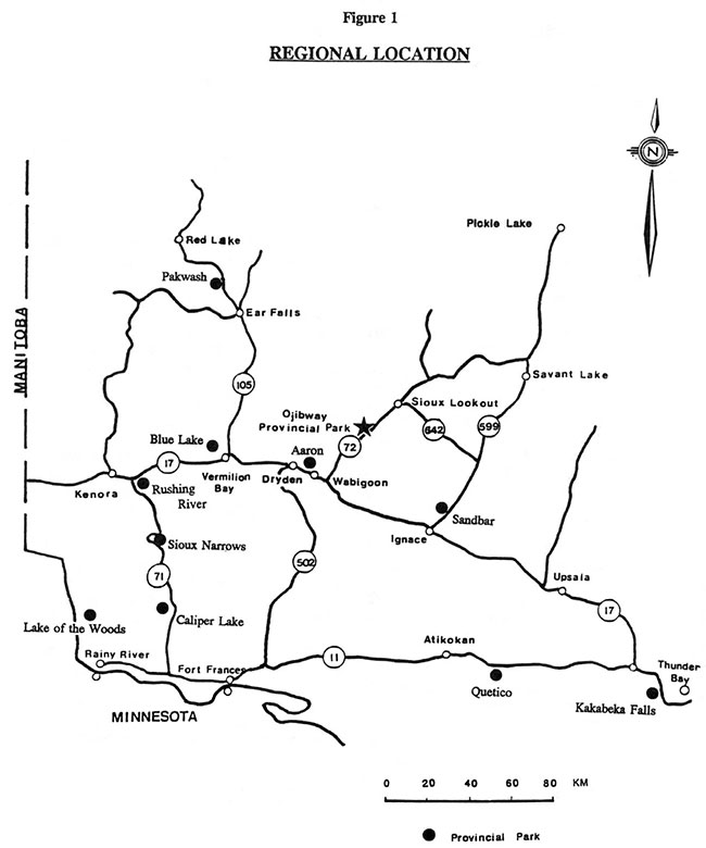
Ojibway Provincial Park is located on Highway 72 twenty-five (25) kilometres southwest of the Town of Sioux Lookout. The Park is within the townships of Vermilion, Jordan and Pickerel in the District of Kenora, and is administered by the Sioux Lookout District of the Ministry of Natural Resources. Figure 1 illustrates the location of the Park relative to other established Parks in the area.
The Park was created in 1963 by Ontario Regulation 117-63. The original size was 2,481 hectares (6,130 acres). Since that time boundary changes have taken place so that by 1971 Ojibway Provincial Park encompassed an area of 2,630 hectares.
The Park, which lies in the central portion of the Canadian Shield, is characterized by the Superior Province, which extends from Lake Winnipeg in Manitoba to Ungava Bay in northern Quebec, and the Wabigoon Subprovince, which lies within the Minnitaki-Little Vermilion Metavolcanic belt.
Existing evidence indicates archaeological sites are located within the park boundary.
The climate of the park area is characterized by long cold winters and short warm summers. It is situated on the southern margin of the Boreal Forest Region in the section described by Rowe (1972) as the Upper English River. Vegetation type is characterized by a predominantly coniferous forest cover and forms part of the transition zone between the Great Lakes - St. Lawrence forest and the Boreal forest.
Park facilities attract both day-users primarily from the local area and repeat campers from the United States (Minnesota, Wisconsin, Illinois) who consider the park as their main destination.
The greatest appeal of the Park will likely continue to be its scenic and recreational values and the peace and quiet it offers visitors.
The management policies contained in this 20 year plan will provide direction for the orderly development of the Park, and guide its management into the next century.
2.0 Classification
The Ministry of Natural Resources has classified Provincial Parks into the following categories: Wilderness, Recreation, Waterways, Natural Environment, Nature Reserve, and Historical.
Ojibway Provincial Park was originally classified as a Recreation Park in 1963. The West Patricia Land Use Planning exercise conducted during the early 1980's recommended that the classification of the Park be changed to Natural Environment owing to its resource base significance and its potential for low intensity recreational opportunities. This change in classification is further elaborated upon in Section 12.0.
Boundary adjustments in the early 1970's increased the park area from 2,481 hectares to 2,630 hectares. The major concentration of development is restricted to the southerly shores of Little Vermilion Lake. In addition to the Park providing a recreational role, various natural features within the Park warrant protection. Ojibway Park contains significant local earth and life science features, including natural wild rice stands, and White Pine and Red Pine stands which are at the northern limit of their ranges.
This Park Management Plan has been prepared in accordance with the natural environment class guidelines as set out in the Ontario Provincial Parks Planning Management Policies.
Figure 1: Regional Location Ojibway Provincial Park
Enlarge Figure 1: Regional Location Ojibway Provincial Park
3.0 Park goal
"The goal of Ojibway Provincial Park is to protect a provincially significant landscape with associated representative plant, animal, geological and cultural features and to provide high quality recreation and heritage appreciation experiences."
4.0 Objectives
4.1 Protection
"To protect provincially significant elements of the natural and cultural landscape of Ontario."
Ojibway Provincial Park protects major landscape units representative of the Upper English River Forest Section and the Wabigoon Subprovince of the Canadian Shield and glacial features including morainal ridges associated with the Wisconsin age of continental glaciation.
Also protected are the representative boreal vegetative communities, as well as those from the Great Lake - St. Lawrence Forests which are found at the northern limit of their range (e.g. red and white pine).
The natural environment classification is appropriate for Ojibway Provincial Park as it protects the earth and life science features of the Park.
4.2 Recreation
"To provide provincial park outdoor recreation opportunities ranging from high intensity day use to low intensity back country experiences."
To meet this objective, park management for recreational opportunities will incorporate:
- moderate intensity car camping and day use
- low intensity back country day use; and
- day use on Little Vermilion Lake
If fully utilized, the Park has the capacity to provide 5,400 camper night and day use opportunities annually. During 1991 Ojibway Provincial Park received 7,340 visitors, with sales of 1,472 campsite permits and 559 day-user permits. Based on 1991 statistics, the average camping party size was 3.4 people and the average length of stay was 3.2 days. Campsite occupancy in the park during July and August of 1991 was 23%. The majority of campers were repeat visitors from the United States (Minnesota, Wisconsin, Illinois) and consider the Park as their main destination.
The Park will continue to offer day use recreation and facility-based camping. The 11.0 kilometres of self-guided hiking trails within the Park provide the opportunity for hiking and exploring in an attractive natural environment.
4.3 Heritage appreciation
"To provide opportunities for exploration and appreciation of the natural and cultural heritage of Ontario."
The visitor services program will be used to encourage park users to learn about the natural features present in the Park and their relationship to Ontario’s heritage.
The self-use programs will provide appreciation of the natural and cultural values of the park environment. The primary theme for the self-use program is the natural history of the Park, including ecology, vegetation, hydrology and ecology, as well as the history of man’s settlement in the immediate area (refer to Section 6.5).
Opportunities for low-intensity recreation will provide for individual appreciation and enjoyment of these various park values.
Figure 2: Park Boundary Ojibway Provincial Park
Enlarge Figure 2: Park Boundary Ojibway Provincial Park
Figure 3: Park Zoning Ojibway Provincial Park
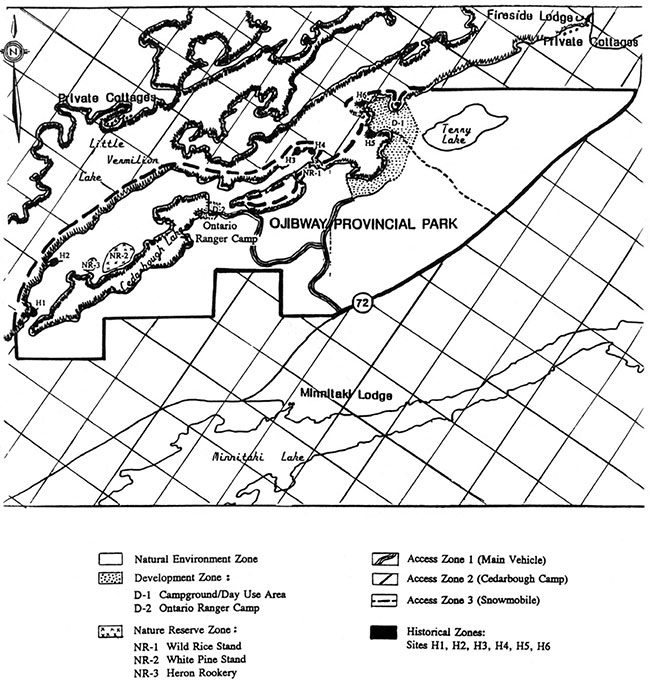
Enlarge Figure 3: Park Zoning Ojibway Provincial Park
4.4 Tourism
"To provide opportunities for Ontario residents and out-of-province visitors to discover and experience a distinct region of the province.
The Park provides day use and camping opportunities for travelers and the local population.
Tourism traffic to the Park will serve to provide economic spin-offs. to the community of Sioux Lookout and perhaps to local outfitters (selling ice, minnows, etc.). Greater economic impact can be attained by encouraging visitors to stay in the area longer by providing local attractions.
5.0 Park boundary
Since Ojibway Provincial Park was designated under the Provincial Parks Act in 1963, two changes have been made to the park boundaries.
In October 1970 the Park was reduced by 91.0 hectares as a result of the relocation of Highway 72. In January 1971 the boundary was extended by 122 metres into Little Vermilion Lake, increasing the area by 240.5 hectares. The Park now encompasses an area of 2,630 hectares of Crown land. With the exception of a few parcels of patented land, the area surrounding the Park is also Crown land. The parcels of patented land are four tourist establishments located close to the Park, and several private cottages at the east and west ends of Little Vermilion Lake (Figure 2).
6.0 Zoning
The lands and waters within Ojibway Provincial Park have been zoned for the purposes of recognition and protection, so that they may be allocated to their most appropriate use. (Figure 3). Acceptable land use activities and types of development are specified by zone classifications.
6.1 Development zones (183 ha.)
The main development zone of the Park is found on the south shore of Little Vermilion Lake. This zone (Figure 3, D-1, 163 ha.) includes all facilities and improvements to the Park area, such as buildings, campgrounds, roads, days use area and parking lots. A second development zone (Figure 3, D-2, 20 ha.) includes the Ontario Ranger Camp which is located on the northeast shore of Cedarbough Lake.
Generally, areas of established development are a reflection of relatively high development capability.
Any additional development will be restricted to the existing development zones in order to reduce impact on the remainder of the Park.
6.2 Nature reserve zones (20 ha.)
The nature reserve zones include those significant earth and life science features in the Park which require management distinct from adjacent areas.
6.2.1 NR-1, Wild Rice stand (8 ha.)
The inlet known as "Chicago Bay' on the south side of Little Vermilion Lake contains a natural wild rice stand.
6.2.2 NR-2, White Pine stand (10 ha.)
This is a unique stand of White Pine on the north side of Cedarbough Lake. The mature trees are approximately 120 years old with basal diameters of up to one metre and heights of 30 to 40 metres. Within Ontario it is established at the most northerly limit for this tree species range.
6.2.3 NR-3, Heron Rookery (2 ha.)
At the west end of Cedarbough Lake along the north shore and some 400 metres inland an active heron rookery exists. There are approximately fifteen (15) established nests, of which at least ten (10) are definitely active. The "Management Guidelines for the Protection of Heronries in Ontario" will be applied by maintaining a buffer around this zone.
Development in the nature reserve zones will be limited. Trails, necessary signs, minimal interpretive facilities, and temporary facilities for research and management may be permitted, dependent on the sensitivity of the feature.
6.3 Natural environment zone (2,377 ha.)
The natural environment zone (Figure 3) serves to provide site protection for the representative landscape units in the park.
This zone encompasses somewhat rugged, back-country landscapes and constitutes the majority of the park area. It affords protection to significant park values which may not be notable enough to warrant protection in a nature reserve zone.
Classification of a natural environment zone also serves to delineate the land area to be utilized in the development of high quality, low intensity recreational opportunities.
Development in this zone will be limited to back-country camping, hiking trails and route signs where required.
6.4 Access zones (30 ha.)
Access zones serve as staging areas where minimum facilities support use of the natural environment and historical zones. There are three (3) access zones designated in the park (Figure 3). They are the main Park entrance area (Access Zone 1), the Cedarbough Ontario Ranger Camp access area (Access Zone 2), and the old main park entrance area (Access Zone 3) which is used in the winter by the Ojibway Power Toboggan Association.
Development in these access zones will be limited to roads, visitor control structures, basic day use facilities, as well as orientation, interpretive, educational and management facilities.
6.5 Historical zone (20 ha.)
There are six (6) historical zones designated in the Park (Figure 3, H-i to H-6) which incorporate areas of archaeological significance related to the settlement of the area.
Archaeological investigations will be conducted in any previously undisturbed ground areas to be developed for park facilities, such as the moose viewing area.
These sites represent the Laurel, Selkirk, Woodland, Archaic and Blackduck cultural occupations. From these sites a variety of artifacts, including flakes, lithics, tools and ceramics, have been collected and documented.
Resource management priorities in these historical zones will include protection and research. The provision of heritage appreciation opportunities will be a secondary consideration. Development in the historical zones will be limited to interpretive, educational and research management facilities. No permanent access will be created.
7.0 Resource management
The Park will be managed according to the planning and management policies for Natural Environment Class Provincial Parks and in accordance with the following guidelines:
- management of the Park will be directed towards the maintenance of the natural landscape, and specific management direction will be determined by park zone prescriptions; and
- although policies are discussed individually it is recognized that the different resource components are interrelated and that an integrated approach will be required in order for the Park to achieve its objectives.
7.1 Land management
Natural environment and nature reserve zones have been established to provide protection for earth and life science features of the Park.
Refuse and sewage generated by park users will continue to be disposed of outside the Park through certified local facilities. Mineral exploration and mining are not permitted within Provincial Parks.
The present gravel pit which is located within the Ontario Ranger camp development zone will be managed in accordance with a Park Aggregate Resource Management Plan. Any further aggregate requirements for in-park purposes will be imported from sources outside Ojibway Provincial Park.
7.2 Vegetation management
The management of vegetation will be directed towards promoting a healthy and natural diversity of vegetation in Ojibway Provincial Park through a "Vegetation Management Plan". Specifically, this plan will reduce the impact of spruce budworm damage, creating a safer, more aesthetic park for the public.
Copies of this vegetation plan are available under separate cover, from the Ministry of Natural Resources office in Sioux Lookout.
Commercial forestry operations will not be permitted within the Park.
7.3 Fisheries management
Sport fishing will be encouraged as a recreation activity for Park visitors.
Fishery resources of the Park will continue to be managed in accordance with policies and regulations prevailing in this area.
In addition, all fisheries management activities within the Park will adhere to applicable guidelines specified in the Sioux Lookout District Fisheries Management Plan.
The Sioux Lookout District Fisheries Management Plan, 1987-2000, Section 3.5.1 "Provision of Quality Sport Fishing Opportunities", Issue 6, page 18, deals specifically with Little Vermilion Lake. To ensure a sustainable fishery, the lake trout catch and possession limit has been dropped from three to two, and the muskellunge catch limit dropped to one per day, with a possession limit of two. The muskellunge minimum size limit has also been increased from 86 cm to 102 cm. Other tactics also being considered for implementation at a future date are altering the season for game fish and instituting some management techniques for smallmouth bass.
7.4 Wildlife management
The management of wildlife in the Park will be directed towards promoting healthy and diverse populations. Wildlife viewing will be encouraged and enhanced with the further development of hiking and canoeing opportunities. Hunting and trapping will not be permitted.
Nuisance animals may be controlled when necessary to protect human health and safety or the health of species outside the Park. When necessary, animal control measures will be carried out by Ministry of Natural Resources staff.
7.5 Water resource management
To ensure the provision of safe, good water quality for park visitors, drinking water and water in the swimming area will be monitored by Ministry of Natural Resources staff on a regular basis to maintain Ontario Ministry of the Environment drinking water standards and Ontario Ministry of Health water quality for bathing beach standards.
8.0 Operations policies
A Park Operations Plan will be prepared to provide park staff with the necessary information required to operate the park on a day-to-day basis. In addition to addressing the operation policies which follow, the strategy will include such topics as budget, staffing, maintenance schedules, enforcement and emergency services. The provisions of the strategy will be consistent with the approved Ontario Provincial Park Operating Standards, and will be reviewed annually and updated as required. Contracting with the private sector to provide services and operate concessions will be encouraged subject to current government and ministry supply policy. These could include canoe rentals, fire wood delivery or other service contracts such as housekeeping, garbage collection, road maintenance and grass cutting.
8.1 Visitor services
The Visitor Services program at Ojibway Provincial Park will follow the direction established in the Regional Visitor Services Plan. The program will offer a high-quality self-use level of service. It will aid visitors in recognizing, using and enjoying the recreational resources of the Provincial Parks system and Ojibway Provincial Park.
The Visitor Services program will be developed through the following three components; information, interpretation and recreation.
8.1.1 Information
The Ojibway Provincial Park leaflet will be periodically reviewed and upgraded to accurately reflect the resources and recreational opportunities offered in the Park.
Information about the surrounding area natural heritage, facilities and events will also be communicated to park visitors by staff through publications and by park signs.
Efforts will be made to gain cooperation from local organizations by providing updated information on the park facilities and events outside of the Park.
8.1.2 Interpretation
The interpretive program at Ojibway Provincial Park will be basic in accordance with Visitor Services Planning and Program Guidelines. Interpretive trails with trail guides and/or sign posts, and a visual display at the entrance gate will form the main components of the interpretive program. The significant earth and life science features which are exhibited in the Park will be highlighted in published pamphlets.
The park interpretive program will convey the park story through a variety of themes:
Natural history and ecology:
- the significant earth and life science features which are exhibited in the Park, including the white pine stand, wild rice stand and the mosaic of differing communities and ecosystems; and
- the geology of the Wabigoon Belt of the Canadian Shield and its distinctive geological features
History of man in the park environments:
- prehistory of human habitation in the area especially the Laurel and Blackduck peoples as pertaining to their archaeological representation in the Park area (Figure 3, Historical Zones H-1 to H-6)
- early logging and forest industry communities theme; and
- present native use of the land and natural resources of the area
8.1.3 Recreation
Park visitors will be informed of the opportunities for recreational activities offered both in the Park and in the local area. Recreational information will continue to be displayed within the gatehouse.
To complement the use of a trail system, maps will be developed to provide information on minimum impact camping practices to enhance visitors' use and enjoyment of the Park.
Interpretive programs will promote hiking, fishing, and boating, as well as the appreciation of natural features (e.g. flora, red pine stands, etc.). Self-use approaches, including brochures, signed trails and display panels, will be encouraged.
8.2 Marketing
In keeping with the Northwestern Region Marketing Plan an individual marketing plan will be prepared for Ojibway Provincial Park. This plan will be reviewed annually and revised as required.
The marketing plan will indicate how to make the public aware of what the Park has to offer in terms of facilities and the type of outdoor recreational opportunities. One objective is to identify additional recreational user groups by emphasizing the opportunities afforded by the park environment and the facilities and activities located there.
The hosting of special "family days" in the Park for the tourists and residents of Sioux Lookout would further promote park use. A major thrust of the marketing plan will be cooperation with area tourist establishments and local organizations. This is aimed at encouraging both park users and other tourists to stay in the area longer by informing them of recreation and tourist opportunities available within the local area.
8.3 Research
Research which contributes to the knowledge of the natural and cultural values and recreation management of the Park will be encouraged. All research will require approval by the Ministry of Natural Resources. Appropriate research topics may include earth and life science studies, and site planning for future development such as trail location, wildlife viewing area, and further investigation of archaeological sites in the Park.
Regeneration within the developed area of the Park will be monitored to determine the success of the Vegetation Management Strategy.
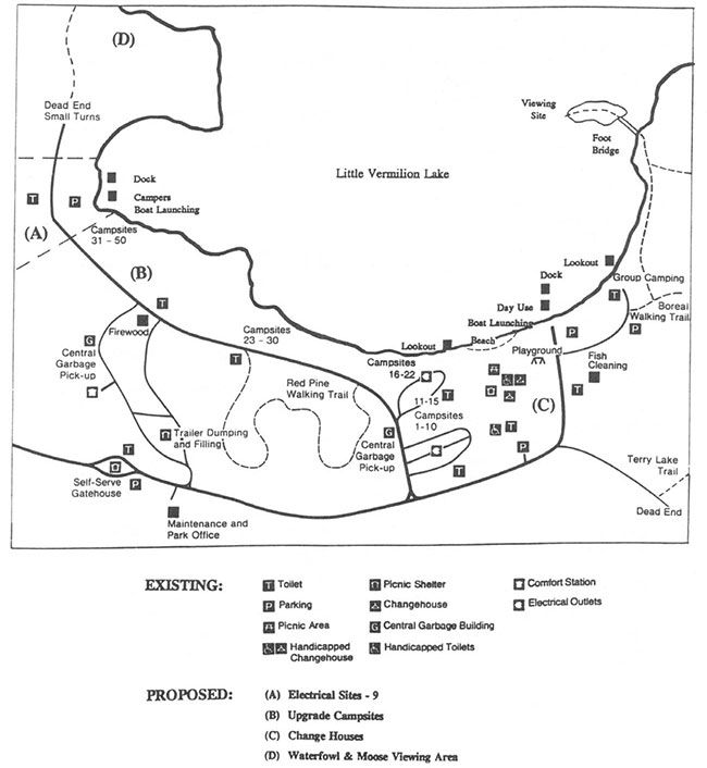
9.0 Proposed development
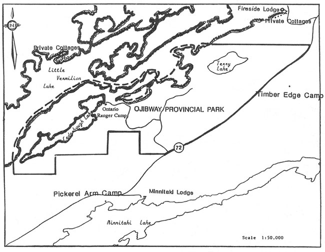
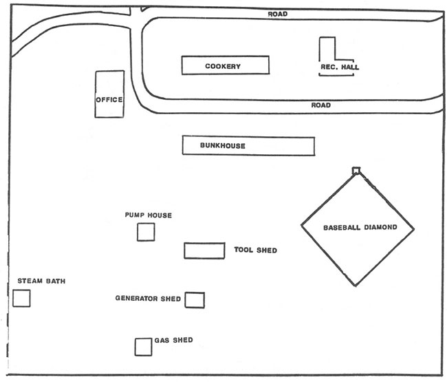
Figure 4A depicts the location of proposed and existing park facilities. Figure 4B maps the Cedarbough Ontario Ranger Camp in some detail. The location, design and materials of all facilities constructed within the Park will, as fully as possible, reflect the character of the Park.
All development will be carried out in accordance with approved site and development plans applicable to a Natural Environment Class Park.
Figure 4A: Park Development Proposed and Existing
Enlarge Figure 4A: Park Development Proposed and Existing
Figure 4B: Cedarbough Ontario Ranger Camp
Enlarge Figure 4B: Cedarbough Ontario Ranger Camp
New facilities will be developed through work program planning or special funding initiatives. All facilities will be managed in accordance with the Park Operating Plan.
9.1 Campground
A Campground Redevelopment Plan will be prepared which will specify improvements to existing campground facilities and guide construction of future developments according to Natural Environment Class Park Standards.
Contingent upon funding and the development of specific site plans, the following improvements will be undertaken.
Many of the campsites require reconstruction and regeneration. These campsites will be relevelled with parking areas upgraded.Vegetation will be managed according to the Vegetation Management Strategy.
Nine (9) sites in Area A will be upgraded to provide electrical service. These campsites -will also be relevelled with parking areas upgraded. (Figure 4A)
9.2 Day use facilities
Existing trails within the Park will be upgraded with new signs and interpretive information.
Due to their deteriorated state, upgrading of the existing change houses will be carried out as soon as possible.
9.3 Trail development strategy
A Trail Development Strategy will be prepared to guide any future development within the natural environment zone, or within the nature reserve zones incorporating site planning with resource protection, recreation management and resource interpretation components.
9.4 Other facilities
Proposals for new facilities have been considered and are among the priorities for construction. These include a waterfowl and moose viewing area near the wild rice stands on Little Vermilion Lake.
The possibility of any new facilities will be subject to further study and public review as part of the planning process.
10.0 Plan implementation priorities
Implementation of this Management Plan will involve resource management operations and site planning, visitor services and facility development. Implementation of this plan is contingent upon funding approval through work planning and other funding sources.
10.1 Implementation plan
Implementation of this Management Plan will involve the preparation of operating, trail development, vegetation management and marketing plans.
All day to day park activities will be guided by a park operating strategy which will be updated when the management plan is approved. Implementation will be dependent on funding through work planning and other funding sources.
10.2 Park development priorities
Priorities for development of park facilities have been determined through an examination of the following: existing and future program needs; present and projected levels of visitation; and the structural condition of present park facilities.
Proposed projects are listed below in order of priority.
- Implementation of the Vegetation Management Plan within the development zone
- Campground upgrading:
- additional nine (9) sites electrified; and
- campsite redevelopment and rehabilitation
- Change-house upgrading
- Develop new trail to waterfowl and moose viewing area
11.0 Public consultation
The Ministry of Natural Resources is committed to a policy of public consultation. The scope of public involvement in a management plan will vary directly with the significance of the park resources and the level of concern and interest in the planning issues related to the Park.
Public consultation during this management planning process has involved the following components:
- The Ojibway Provincial Park Background Information document and the Preliminary Park Management Plan, were made available for public review and comment. Advertisements in the Sioux Lookout Explorer and Dryden Observer newspapers notified the public of plan availability and review period
- Copies of both documents were placed in the Sioux Lookout Public Library. Original documents were available in the Sioux Lookout District Office. Additional copies were placed at Ministry of Natural Resources offices in Ignace, Dryden, Fort Frances, Red Lake and Kenora
- Direct mailing also occurred at the beginning of each phase of the planning process. Documents were sent to the following: neighbouring land owners; the Municipality of Sioux Lookout; other government agencies such as the Ministry of the Environment; provincial and federal members of parliament; environmental and recreation-oriented interest groups; the Local Services Board; and interested members of the public
- A questionnaire was distributed at Ojibway Park during the period June 1990 to the end of August 1990. The questionnaire was designed to evoke park user response for input to the park plan; and
- All public input was analyzed and incorporated into the final draft of the Ojibway Provincial Park Management Plan. This correspondence was received during the public review period of the Background Information document and the Preliminary Management Plan
The following is our response to public concerns.
- The Ministry of Northern Development and Mines responded to supporting multiple resource use in the natural environment zones within the park
In keeping with the legislation for Provincial Parks in Ontario, activities such as timber harvesting, mining, trapping and commercial fishing are excluded from parks.
- The majority of internal and public response supported the reclassification of the Park
However, two respondants who advocated multiple resource use in parks felt that Ojibway should remain a Recreation Park.
The initial classification of Ojibway as a Recreation Park occurred at its creation in 1963. The draft West Patricia Land Use Plan (1982) recommended the change to Natural Environment classification. Recreation Parks are areas which support a wide variety of outdoor recreation opportunities for large numbers of people in relatively small, attractive surroundings. Natural Environment Parks incorporate natural, cultural and recreational features, all located in larger areas of over 2,000 hectares is size. Resource extraction would be excluded regardless of the park classification. This change to Natural Environment more accurately reflects the zoning of this park. It does not change the management of Ojibway Provincial Park.
- Concerned about the method that the Ministry of Natural Resources will use to treat budworm
The Vegetation Management Strategy addresses the budworm problem. It proposes realistic changes that can be made at a reasonable financial cost and will be conducted in a manner which will minimize the visual and acoustical impacts upon park visitors.
- The need for additional electrical sites, approximately nine in Area 5 of the park, was identified in the Background Information and in the questionnaire distributed to park users during the summer of 1990
Additional sites will be developed, contingent on funding and the preparation and approval of development and site plans (Figure 4A) in accordance with provincial standards for Natural Environmental Parks.
- Cedarbough Ontario Ranger Camp should continue its role as an educational facility in the Park
The goal of the Ontario Ranger Program is to provide the Ontario Rangers with working experiences and educational instruction to improve their understanding and appreciation of integrated resource management so that they may provide useful support to Ministry work programs, and have the opportunities for career progression within the Ministry of Natural Resources.
Participation by the Ontario Rangers will enhance the interpretive role of the park’s natural features. The Ontario Rangers will continue assisting in the park’s maintenance program which will enhance the educational and learning aspects associated with the natural features of the area. They will also learn, through participation in the Ontario Ranger Program, the Provincial Park goals and objectives.
- The Federation of Ontario Naturalists requested that a larger area be designated as "Nature Reserve Zone" in proximity to the heron rookery
The "Management Guidelines for the Protection of Heronries in Ontario" are being applied to the heron rookery. The zone beyond the 2 hectare "Nature Reserve" is a Natural Environment Zone. There is no plan for development, such as trails, in the 1 km. zone adjacent to the rookery.
- A local interest group requested that snowmobiling be given separate consideration from other sports associated within the park and asked that utilization of the Hudson - Sioux Lookout snowmobile loop be allowed during the winter months. At the same time, one interest group requested that snowmobiling be discouraged in the Park
Through public response to the Background Information document, the Ojibway Power Toboggan Association of Sioux Lookout identified the use of the old park access road and the connecting roadway to the east boat launching ramp as a snowmobile trail during the winter season. This section of the trail within the Park is part of their Hudson-Sioux Lookout loop.
The only designated trail will include the Snowmobile Access Zone shown on Figure 3.
- Major support was received for the development of a trail and viewing area in the vicinity of the wild rice stand on Little Vermilion Lake
The trail will be designed as per Provincial Park Development Standards to protect any significant earth and life science features. Details, such as timing of construction to minimize disruption, will be outlined in a plan prior to construction of this trail.
12.0 Plan review and amendment
This Ojibway Provincial Park Management Plan will be reviewed as warranted during its 20 year time frame. As a minimum requirement, the plan will be reviewed ten years after approval.
Review of this plan may become necessary from time to time to ensure its continuing relevance. This need may arise in the face of changing circumstances where park objectives and management policies are no longer appropriate. It may also be necessitated by a proposal which represents a significant departure from the original direction and intent of the plan, or in the event that during its term the plan is rendered obsolete.
Revisions to the approved Park Management Plan, whether as the result of a scheduled or unscheduled review, may require:
- a re-evaluation of the original background information and issues used in the original planning program
- a determination as to the scope of the review which could range from concluding that the provisions of the original plan were still appropriate to application of the entire park management process if it was felt that the plan had major shortcomings in light of current knowledge
- provision of a formal opportunity for public involvement in the review, which could range from an Invitation to Participate and notification of results, to the application of the complete park planning process; and
- production of the Park Management Plan Review document or a new Management Plan
13.0 References
Beaudry, M., Lavender, A., and Sexsmith, J.L. 1983. A History of Selected Parks of Northwestern Ontario. Ministry of Natural Resources, Northwestern Region, Kenora.
Bowman, I., and Siderius, J. 1984. Management Guidelines for the Protection of Heronries in Ontario. Ministry of Natural Resources, Wildlife Branch, Toronto.
Goddard, W.A. 1983. Life Science Inventory of Ojibway Provincial Park Environmental Planning Series Ministry of Natural Resources, Northwestern Region, Kenora.
Lambert, P.J.B. 1983. Archaeological Survey of Ontario Provincial Parks in the Kenora Region and Assessment of Archaeological Resources in Adjacent Geographic Areas. Ministry of Natural Resources, Northwestern Region, Kenora.
Ministry of Natural Resources. 1989. Ontario Provincial Parks Statistics. Ministry of Natural Resources, Provincial Parks and Natural Heritage Policy Branch, Queen’s Park, Toronto.
Ministry of Natural Resources. 1988. Sioux Lookout District Fisheries Management Plan 1987 - 2000. Ministry of Natural Resources, Sioux Lookout District.
Ministry of Natural Resources. 1978. Ontario Provincial Parks: Planning and Management Policies. Provincial Parks Branch, Toronto.
Ministry of Natural Resources. 1989. Ojibway Provincial Parks Interim Management Statement. Ministry of Natural Resources, Sioux Lookout District.
Nobel, T. 1977. Life Science Inventory Check Sheet for Ojibway Provincial Park - Wild Rice Marsh. Pine. Unpublished.
Roed, M.A. 1980. Northern Ontario Engineering Geology Terrain Study 22. Wabigoon Lake Area (N.T.S. 52F/NE) District of Kenora; Ontario Geological Survey.
Rowe, J.S. 1972. Forest Regions of Canada. Canada Department of the Environment, Canadian Forestry Service.
Seim, G. 1989. Geological Overview of the Area Within Ojibway Provincial Park. Unpublished.
Ministry of Natural Resources. 1990. Ojibway Provincial Park Background Information. Ministry of Natural Resources, Sioux Lookout District.
Ministry of Natural Resources. 1991. Ojibway Provincial Park Preliminary Management Plan. Ministry of Natural Resources, Sioux Lookout District.