Opasquia Provincial Park Management Statement
This document provides policy direction for the protection, development and management of Opasquia Provincial Park and its resources.
August, 1986
Regional Director’s approval statement
This Interim Management Statement will provide interim direction for the management of Opasquia Provincial Park until a comprehensive Park Management Plan is prepared.
This statement will provide the basis for the subsequent preparation of the Park Management Plan.
I am pleased to approve this Interim Management Statement for Opasquia Provincial Park.
D. R. Johnston
Regional Director
Northwestern Region
Introduction
The purpose of this Interim Management Statement is to identify:
- park values which are to be protected;
- resource management prescriptions necessary to protect these values; and
- restrictions on use of natural resources within the park.
This Interim Management Statement is not intended to replace a Park Management Plan. Rather it is intended to guide the use of natural resources and related activitites within the park until such time as a Park Management Plan is prepared.
The guidelines that have been developed are based on information contained in the Backgrounder - Land Use Guidelines.
Background information
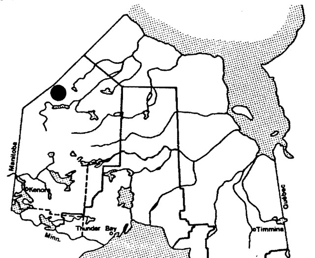
- Name: Opasquia Provincial Park
- Proposed class: Wilderness
- M.N.R. district: Red Lake/Sioux Lookout
- M.N.R. region: Northwestern
- Total area (ha): 473,000
- Land:
- Water:
- Site region: 2W-Big Trout Lake
- Site district: 2W-1
- Date in regulation: 1983.06.02
Regional setting map
Targets
1. Life science representation
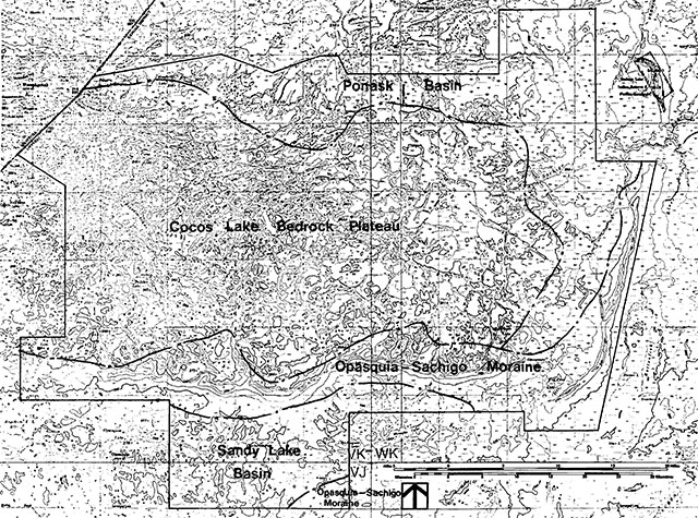
Site type/landscape unit
- Ponask Basin
- Cocos Lake Bedrock Plateau
- Opasquia/Sachigo Moraine
- Sandy Lake Basin
Species/communities
- 31 site types
- Discontinuous permafrost features
- Wolverine habitat
2. Earth science representation
Geological theme
- Late Archean Tectonic
- Helikan Tectonic
- Timiskaming Interstadial
Feature
- Mafic and ultramafic intrusive rocks
- Molson diabase dikes
- Sachigo and Opasquia Moraines
- Lake Agassiz clays and strandlines
3. Cultural resource representation
- Theme: Unknown
- Theme segment: Unknown
4. Recreation opportunities
- Day use: Not Applicable
- Car camping: Not Applicable
- Wilderness/back country: 50,000 opportunities
Inventories
| level/type | earth science | life science | cultural | recreational | other |
|---|---|---|---|---|---|
| reconnaissance/completion date | April 1979 | December 1979 | June 1980 | ||
| detailed completion date | |||||
| required? | yes | yes | yes | yes |
Management guidelines
I. Land tenure
There is presently one Crown lease and eight land use permits located within the park in association with Big Hook Wilderness Camps.
Guideline:
The above land tenure will continue and be further addressed during the preparation of the park management plan. Requests for any further forms of land tenure will not be considered.
II. Land acquisition/disposition
There is presently no patented property located within the park. The disposition of Crown-owned lands will not be considered pending the completion of the pa~k management plan.
III. Existing/proposed development
There is no existing or proposed park-related development within the park. Proposals for park development will only be considered as part of the park management plan.
IV. Recreational activities
The only recreational activities that presently occur are sport hunting and fishing in association with the one existing tourist facility and a limited amount of camping/canoeing.
Guideline
Sport hunting and fishing will be permitted to continue as governed by existing regulations and will be further addressed during the preparation of the park management plan.
Camping will be permitted to continue and normal park fees will apply.
Access into the park is almost completely restricted to aircraft. The Ontario Regulation controlling aircraft landings in the park authorizes the District Manager to permit such landings. Aircraft landings in association with the eight land use permits and one Crown lease will be permitted to continue and will be authorized by the District Manager. All other aircraft landing must receive prior written approval from the District Manager.
V. Commercial activities
Big Hook Wilderness Camps is the only tourist operation located within the park. This operation consists of one main base lodge, five outpost camps and eleven boat cache sites.
A small amount of personal use fuelwood is harvested on an annual basis.
There is presently one commercial fishery on East Lake operated by Mr. J. Loonfoot. Existing equipment and facilities in association with this activity include one cabin and motorized boats.
All or portions of 16 native traplines are located within the park. Three trap cabins are known to exist in the park in association with this activity.
Guidelines
The existing tourist facilities/development will be permitted to continue. No new expansion or development will be permitted. The maintenance of existing facilities is permissable and any requests for transfer of ownership will be considered consistent with resource capability. The eleven existing boat caches associated with this activity will be permitted to continue. Where funding is approved, an assessment of the fisheries resources of the park will be undertaken to determine if the allocation of the boat cache sites reflects the fisheries capacity of the lakes. It may be desirable to either relocate some boats to other lakes in the park or to lakes outside of the park boundary.
Personal use fuelwood harvesting within the park will be permitted to continue.
Commercial fishing operations on East Lake will be permitted to continue at the existing level of operation. No new developments will be permitted except on undeveloped existing quotas. In the event of a request for the transfer of ownership of this licence, the Ministry will attempt to relocate this activity to other waters outside the park boundary.
Trapping in the park on the 16 native operated traplines will be permitted to continue. Requests for new trap cabins will be considered on a case by case basis in consideration of park values.
Mineral exploration/extraction will be permitted to continue as per the Backgrounder - Land Use Guidelines. This activity will only be authorized by the issuance of an Exploratory Licence of Occupation under Section 190 of the Mining Act.
Aggregate extraction and the extraction of peat will not be permitted within the park.
VI. Native interests
Opasquia Provincial Park is located within Treaty Areas #9 and #5. The park area is presently utilized for traditional hunting, fishing and trapping activities.
Guideline
The above traditional Treaty Indian uses will be permitted to continue. The Ministry is committed to meeting with the Native communities of Sandy Lake, Sachigo Hills, Garden Hill and Island Lake from time to time as may be deemed necessary to discuss/mitigate the impacts of the park on traditional Native uses of the area.
VII. Natural resources
The park lies within MNR's extensive fire protection zone in which the degree of protection is governed by the availability of fire suppression resources and the possible threat to human life and property. Fire suppression will primarily be geared to responding to concerns from Native communities and the protection of property within the park.
Where funding is approved, the Ministry will undertake fisheries assessment work within the park to ensure that fish stocks are not being overharvested.
VIII. Cultural resources
There are three known archaeological sites located within the park. Management efforts will be directed towards the protection of these sites.
IX. Client services
Information on the earth and life science, and recreational values of this wilderness class park will be made available to the public.
X. Research
Research activities that enhance our scientific and resource knowledge of the park will be encouraged.
XI. Marketing
A marketing strategy for this wilderness park will be addressed during the preparation of the park management plan.
Sources/references
Gray, Stephen L.., “Life Science Systems Planning Report”, West Patricia Land Use Plan, 1980.
Harvey, E. T., “Earth Science Systems Planning in the West Patricia Planning Area,” Final Report., 1980.
Harvey, T., S. L. Gray, B. Thacker., “Landscape Units of the West Patricia Land Use Planning Area”, 1980.
O.M.N.R., “Backgrounder Land Use Guidelines.” 1983.
Figure 2: Landscape units
Enlarge Figure 2: Landscape units map (PDF)
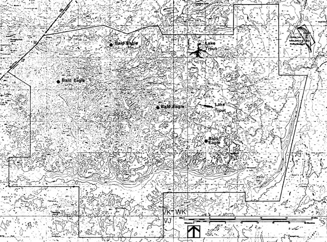
Figure 3: Life science features
Enlarge Figure 3: Life science features map (PDF)
Earth science features - Figure 4
- granitic textures and compositions
- conspicuous lineaments nw-se and ne-sw
- heavily amphibolitized fragments
- Opasquia end moraine - spectacular kettles
- ice contact faces
- flanking outwash
- evidence of readvance
- Sachigo Interlobate moraine - continuous crevassed kettles
- eastern side berms, western side contact
- flanking outwash
- Sachigo Hills
- L. Agassiz standlines - sequence
- spit, other variety of shoreline features
- clay deposits, north of Opasquia
- organics permafrost
- high relief bedrock fractures
- crag and tail features
- DeGeer moraines
Figure 4: Earth science features
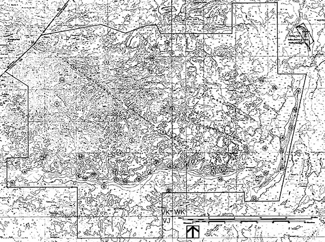
Enlarge figure 4: Earth Science Features map (PDF)
Figure 5: Cultural resources
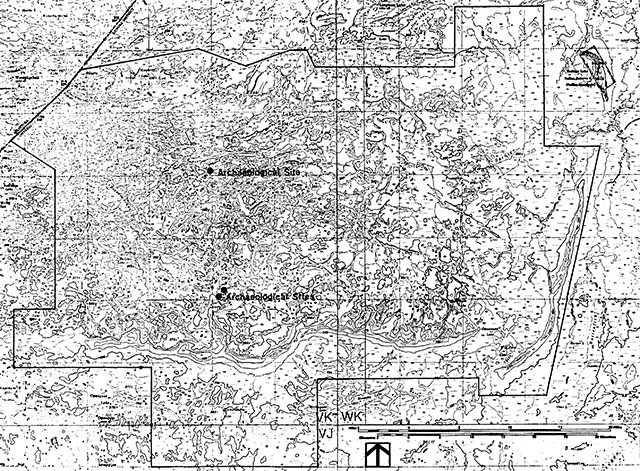
Enlarge figure 5: Cultural Resources map (PDF)
Figure 6: Development
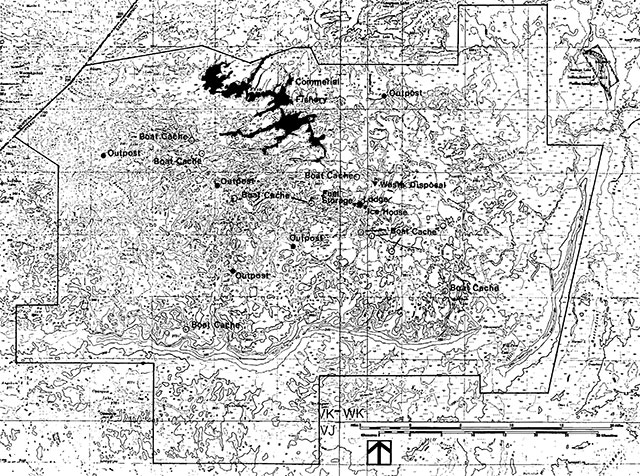
Enlarge figure 6: Development map (PDF)
Figure 7: Traplines
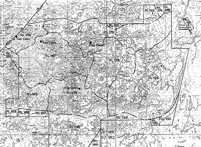
Enlarge Figure 7: Traplines map (PDF)
Appendices
Table I: Recommended wilderness park candidates
| Name | MNR Region | Size (ha) | Mineral Exploration/Development1 | Hunting1 | Trapping1 | Commercial Tourism1 | Commercial Fishing1 | Bait Fishing1 | Other1 |
|---|---|---|---|---|---|---|---|---|---|
| 1. Woodland Caribou | NW | 450,700 | Yes | Yes | Yes | Yes | Yes | Yes | Wild rice |
| 2. Opasquia | NW | 460,500 | Yes | Yes | Yes | Yes | Yes | ||
| 3. Wabakimi (Whitewater) | NC | 155,000 | Yes | Yes | Yes | Yes | Native only | Yes | |
| 4. Lady Evelyn/Smoothwater | NE | 72,400 | Yes | Yes | Yes | Yes | Cottages to be phased out; road to remain | ||
| 5. Killarney Extension | NE | 13,800 | Patents only | Phase out | Phase out | Yes | Cottages/hunt camps to be phased out | ||
| 6. Kesagami Lake | N | 54,200 | Yes | Yes | Yes | Native only | Yes |
1Uses recommended to continue prior to and after regulation
Ontario nature reserves program - Life science inventory check-sheet: Opasquia Lake Candidate Wild. Park
- Name: Opasquia Lake Candidate Wild. Park
- Map name: Opasquia Lake
- Map number: 53F
- UTM ref.: VK 00/30
- County, district or regional municipality: District of Kenora, Patricia Region
- Lat: 53°30'N
- Long.: 93°00'W
- Alt. min: 252 m
- Alt. max.: 409 m
- Locality: Opasquia (? Settlement)
- Township: Not applicable (N/A)
- Lots: (N/A)
- Concessions: (N/A)
- Area: c 1,406,000
- acres; c 569,000
- ha (N/A)
- Ownership: Crown
- Administration: Ministry of Natural Resources
- Forest region and district: Boreal – North. Conif
- Site district: 2W – 1
- Map region and district: NW – R.L. & S.L.
- Conservation Authority: (N/A)
- Aerial photographs: Opasquia Candidate Wilderness Park
- Federal Series Air Photos, Scale 1:60,000 (or approx. 1 inch: 1 mile) from about 1954
- Roll: Photo
- A 14309: 133 - 138
- A 14647: 34 - 44
- A 14199: 27 - 37
- A 14199: 54 - 65
- A 14199: 119 - 131
- A 14199: 143 - 154
- A 15518: 5 - 13
- A 14213: 57 - 65
- A 14208: 40 - 53
- A 15689: 4 - 16
- A 14225: 85 - 99
- A 14225: 45 - 59
- A 14359: 108 - 121
- A 14530: 27 - 41
- A 14215: 94 - 104
- A 14220: 21 - 30
- Roll: Photo
- Federal Series Air Photos, Scale 1:60,000 (or approx. 1 inch: 1 mile) from about 1954
Physical and biological features
Representation of the following:
- Cocos Lake Bedrock Plateau L. U. (entirely)
- Opasquia - Sachigo Moraine L. U.
- Ponask Basin L. U.
- discontinuous permafrost features
- 31 site types (see attached)
Data sheets attached
- None
Major information sources
Harvey and Gray, 1979 - W. P. P. Tech. Report No. 5
Harvey, 1979 - W. P. P. Tech. Report No. 3
Evaluation and priorities
Date compiled
December, 1979
Compiler
S. L. Gray, P.O. Box 89, Cochenour, Ontario P0V 1L0
Physical description
Bedrock
see Harvey and Gray, 1979 and Harvey, 1979
Physiography
Soils
Groundwater
Surface water
Shores
Climate
Disturbance history
Opasquia (1 settlement); winter road NW from Angekum Lake to Island lake; and trappi is anticipated to be active throughout. Otherwise, no apparent human influences.
Vegetation summary
[No values given]
Number
Association or complex
Area (ha)
Soil texture
Moisture Regime
Micro-climate
Soil pH
Data sheet
Evaluation
Outstanding associations
Significant species or features
No significant species are known in the Opasquia Candidate Park; however, outside the Candidate, an area to the northeast is known to have a high number of wolverine trapping and track records. See recommendations attached.
No significant features are known.
Potential disturbances and threats
None anticipated. Unmerchantable for timber.
Brief summary
Life science features could be represented with a smaller area within the Candidate Park.
Recommendations
For representation of typical vegetation, see attached.
Opasquia candidate wilderness park
Significance:
- Representation of 31 site types in the Candidate Park (see figure 2); however, drumlins and drumlinoids (and some 4 site types) are not represented from the Ponask Basin Landscape Unit. Discontinuous permafrost (e.g. extensive collapse scar areas) is well represented in the east end in the Ponask Basin L. U.
- Bedrock and moraine site types are over-represented in the Cocos lake Bedrock Plateau and Opasquia - Sachigo Moraine Landscape Units.
Recommendations:
- The Candidate Park area is larger than necessary for some life science purposes, and at the same time, incompletely represents the Ponask Basin Landscape Unit and could provide habitat for wolverine with a boundary extension. The minumum areas required are as follows: Cocos Lake Bedrock Plateau L. U., 550 km2; Opasquia - Sachigo Moraine L. U., 350 km2; Sandy Lake Basin L. U., 300 km2; and Ponask L. U. 250 km2.
- The Cocos Lake Bedrock Plateau L. U. is represented in the upstream portion of watershed unit 4 AC-2.
- The Opasquia - Sachigo Moraine L. U. is represented in a watershed unit adjacent to the Cocos Lake Bedrock Plateau by an area about 200 km2. To complete the area representation and provide a contrasting north-south orientation an subsequently different ecoclimatic conditions and site types, an area in watershed units 4 CO-41 and 4 CO-40 is shown.
- The Sandy Lake Basin and Ponask Basin L. U. should be represented in the Ponask Lake to Sachigo Lake area, rather than in the Candidate Park area, due to an anticipated higher wolverine population in that area (after Novak, 1975). Mastin, (1979) reports the minimum “territory needed by a single wolverine” as 770 km2 (300 mi2). The nature reserve zones of 300 km2 and 250 km2 for these two L. U. are therefore located in this area. This is further supplemented by a wilderness zone of about 1,350 km2. A high percent of the locations of old records are included in this area. The strategy of delimiting this area of about L900 km2 is to provide habitat for a wolverine population; however, because of inadequate information on the biology of this animal, the factors resulting in the presumed higher population, as well as the size of the population, are unknown.
- The Sandy Lake Basin L. U. is incompletely represented as extensive horizontal fens and peat plateaus are not found south of Sachigo Lake. An area north of Rottenfish Lake includes these features, as well as sloping fen. This area is used in conjuction with representation of the Opasquia - Sachigo Moraine L. U. as previously described.
- The Ponask Basin L. U. is incompletely represented as wave-washed drumlins and drumlinoids and a brown sandy silt till are typical of the northern part of this L. U. An area east of Pierce Lake is added to complete the representation of this L. U.
- The recommended system of nature reserves includes 37 site types (see figure 3).
References
Cox, E. T., editor, ? 1974. Unpublished maps of scale 1:250,000 where the watershed boundaries correspond to those of Sport Fisheries Branch, 1974.
Harvey, E. T., 1979. A summary of earth science elements in Opasquia Candidate Wilderness Area (Patricia Portion, District of Kenora). Unpublished report. Northwestern Region Parks and Recreation. Ministry of Natural Resources, West Patricia Parks Tech. Report No.3. 58 pp
Harvey, E. T. and Gray, S. L., 1979. Landscape Units of the West Patricia Planning Area. Unpublished report. Northwestern Region Parks and Recreation, Ministry of Natural Resources, West Patricia Parks Tech. Report No.5.
Mastin, M., 1979. The Controversial Wolverine. Ontario Naturalist, 19:-4-9.
Novak, M., 1975. Recent Status of the Wolverine in Ontario. Unpublished report. Ministry of Natural Resources, Toronto. 17 pp.
Sport Fisheries Branch, 1974. Watershed Divisions, Northern Ontario. Sport Fisheries Branch, Ministry of Natural Resources. Map M6374. Scale 1:1,267,200 or 1 inch: 20 miles.
Figure 2: Vegetative site type identified from the Opasquia Candidate Wilderness Park for the Northern Boreal Forest Site Region (2W)
| Temperature regime | Substrate | Arid | Very Dry | Dry | Dry Mesic | Mesic | Wet Mesic | Wet | Very Wet | Saturated | Open Water |
|---|---|---|---|---|---|---|---|---|---|---|---|
| Colder | Rock | cliff* | cliff | * | |||||||
| Colder | Sand | moraine* | moraine* | moraine | * | kettle lake* | kettle lake | kettle lake | |||
| Colder | Loam | * | |||||||||
| Colder | Clay | * | * | * | * | * | |||||
| Colder | Organic | * | * | * | * | * | |||||
| Normal | Rock | bedrock, cliff | bedrock | bedrock* | bedrock | * | |||||
| Normal | Sand | * | moraine, silty sand till * | moraine, silty sand till * | moraine, silty sand till * | * | * | * | * | ||
| Normal | Loam | silty sand till | silty sand till | silty sand till* | |||||||
| Normal | Clay | clay - silt clay overfill* | clay - silt clay overfill* | clay - silt clay overfill* | clay - silt clay overfill, bog* | clay - silt clay overfill* | clay - silt clay overfill* | * | |||
| Normal | Organic | * | bog* | bog* veneer* |
bog* veneer* |
fen* | * | ||||
| Warmer | Rock | cliff* | * | * | |||||||
| Warmer | Sand | moraine | moraine* | moraine* | * | * | * | * | * | ||
| Warmer | Loam | * | * | ||||||||
| Warmer | Clay | * | * | * | * | * | * | ||||
| Warmer | Organic | * | * | * |
*Site types identified to date
Figure 3: Vegetative site types identified from recommended nature reserve zones in the vicinity of the Opasquia Candidate Wilderness Park for Site Region 2W
| Temperature regime | Substrate | Arid | Very Dry | Dry | Dry Mesic | Mesic | Wet Mesic | Wet | Very Wet | Saturated | Open Water |
|---|---|---|---|---|---|---|---|---|---|---|---|
| Colder | Rock | cliff* | cliff | * | |||||||
| Colder | Sand | moraine* | moraine* | moraine | * | kettle lake* | kettle lake | kettle lake | |||
| Colder | Loam | drumlinoids brown sandy till |
drumlinoids* brown sandy till* |
||||||||
| Colder | Clay | * | * | * | * | * | |||||
| Colder | Organic | * | * | * | * | * | |||||
| Normal | Rock | bedrock, cliff | bedrock | bedrock* | bedrock | * | |||||
| Normal | Sand | moraine* silty sand till * |
moraine* silty sand till * |
moraine* silty sand till * |
* | * | * | * | |||
| Normal | Loam | silty sand till | silty sand till | silty sand till* | |||||||
| Normal | Clay | clay - silt clay overfill* | clay - silt clay overfill* | clay - silt clay overfill* | clay - silt clay overfill, bog* | clay - silt clay overfill* | clay - silt clay overfill* | * | |||
| Normal | Organic | * | bog* | bog* veneer* |
bog* veneer* |
fen* | marsh* | ||||
| Warmer | Rock | cliff* | * | * | |||||||
| Warmer | Sand | moraine | moraine* | moraine* | * | * | * | * | * | ||
| Warmer | Loam | drumlinoids brown sandy silt till |
drumlinoids brown sandy silt till |
* | * | ||||||
| Warmer | Clay | * | * | * | * | * | * | ||||
| Warmer | Organic | * | * | * |
*Site types identified to date
Earth science inventory checklist: Opasquia Candidate Wilderness Area
- Name: Opasquia Candidate Wilderness Area
- Map name: Opasquia
- Map number: 53F
- UTM ref.: VK 00 30
- County, district or regional municipality: District of Kenora
- Lat: 53°30'N
- Long.: 93°00'W
- Alt. min: 252 m
- Alt. max.: 409 m
- Lots:
- Concessions:
- Area: 1,474,000 acres
- Ownership: Crown
- Administration: Ministry of Natural Resources
- Forest region and district: Boreal – NW - Red Lake
- Site district: 2W – 1
- Map region and district: NW – R.L. & S.L.
- Conservation Authority
- Aerial photographs: Opasquia Candidate Wilderness Park
- Federal Series Air Photos,
- Scale 1:60,000 (or approx. 1 inch: 1 mile)
- from about 1954
- Roll: Photo #
- A 14309: 133 - 138
- A 14647: 34 - 44
- A 14199: 27 - 37
- A 14199: 54 - 65
- A 14199: 119 - 131
- A 14199: 143 - 154
- A 15518: 5 - 13
- A 14213: 57 - 65
- A 14208: 40 - 53
- A 15689: 4 - 16
- A 14225: 85 - 99
- A 14225: 45 - 59
- A 14359: 108 - 121
- A 14530: 27 - 41
- A 14215: 94 - 104
- A 14220: 21 - 30
- Roll: Photo #
Earth science features
Representation of the following theme elements:
- Sachigo subprovince, Island Arcs and Basins Environment
- granitic complexes, Tectonic landforms theme
- glacial erosion features, glacial process theme
- Lake Agassiz envi.-Timiskaming Interstadial
- Opasquia- Sachigo moraine system- Timiskaming Interstadial
- discontinuous permafrost, mass wasting process theme
Sensitivity
- wetland areas may contain discontinuous permafrost
Significance
- provincially significant
- Sachigo Hills, Opasquia
- Sachigo moraine system
- outstanding morainic topography, four major landscape units
- possible significant permafrost features
Major reference
- Harvey, E.T. 1979. “A Summary of Earth Science Elements in Opasquia candidate Wilderness Park” West Patricia Technical Report #3, Northwestern Region Parks and Recreation, Ministry of Natural Resources
- Date compiled: April 1979
- Compiler: E. Harvey, M.N.R. Box 89, Cochenour, Ontario P0V 1L0
Bedrock geology
Opasquia Candidate Wilderness Area is underlain by an Early Precambrian (Archean) granitic complex of the Sachigo subprovince (also known as the God’s Lake belt and Cross Lake belt), part of the Superior Province of the Canadian Shield. While detailed mapping is lacking, the terrain consists of composite batholiths ranging in composition from quartz diorite to quartz monzonite with a medium grained, equigranular, hornblende or biotite trondhjemite and medium grained grey to pink quartz monzonite the most abundant. Small portions of hybrid granitic and migmatitic rocks are present but these essentially remain unmapped. Several small lenses of amphibolitized metavolcanics, vestiges of now eroded greenstone belts, have been mapped in the headwaters of the Sachigo River. Several diabase dikes, probably related to the Molson Dike swam of northeastern Manitoba (1400 my), traverse the candidate area. Radiometric dates span a period from 2900 to 2400 my., indicating that the poorly known sequence of emplacement culminated with the Kenoran orogeny, a widespread event of folding and faulting in the Superior Province of the Canadian Shield. Remnants of the original primitive crust may be present but have not been located.
Surficial geology
Opasquia Wilderness Candidate is a headwaters area supplying water for three major drainage systems- the Severn River via Sandy Lake and the Sachigo River, both of which drain northeastwards towards Hudson Bay. The Sagawitchewan River drains into Island Lake, to the northwest which in turn forms part of the God’s River system in Manitoba. The area straddles four landscape units delineated by the author in the West Patricia Planning area. Sandy Lake basin- variable thicknesses of varved calcareous clay in a flat to gently undulating, bedrock controlled basin. Opasquia-Sachigo moraine- morainic upland, typical ice contact shape, containing heavily modified ice contact stratified drift and outwash deposits. Cocos Lake bedrock plain- bedrock upland, highly ractured with variable relief, overlain by wave washed ground moraine and lowlying lacustrine deposits in basins. Ponask basin- underlying ground moraine, heavily modified and wave washed with a thick clay basin on the west side of the Sachigo moraine.
At least 70 percent of the map area has been designated as “bedrock drift complex” composed of discontinuous cover of materials originating from different sources. Topography is the largest factor controlling the distribution of sediments. Bare bedrock upland areas may contain pockets of coarse iumature sands or silts, the winnowed equivalent of ground moraine. Troughs contain variable thicknesses of brown to yellow brown, fining upward, poorly laminated silty clay, frequently overlying and interfingering with a sandy vaterlaid till.
South of the Opasquia moraine, the Sandy Lake basin is filled with variable thicknesses of calcareous chocolate varved clays, grading upwards to unlaminated compact silty clay and usually overlain by organics of a metre or more. Similar deposits extend northward vest of the Sachigo moraine into the Ponask basin.
The Opasquia moraine is a striking landscape feature, a 2 km wide ridge rising up to 100 metres above the surrounding landscape oriented in an east-west direction, marking a prominent ice frontal position of the Opasquia lobe which extended into Northern Manitoba. It has a typical ice contact shape. A gently sloping southern side composed of outwash deposits overlain by a southward fining sequence of lacustrine sediments contrasting with the steep ice contact side containing numerous lobate troughs. Several distinctive features were noted during mapping: evidence at the eastern end for minor readvances not always in exactly the same direction; linear crevassing (kettles) along the crest caused by buried ice blocks melting in situ.
The Sachigo Interlobate moraine is a north-south ridge 150 km long connecting with the Wetiko Hills in Northern Manitoba and forming a striking feature for many miles around. Its interlobate character is defined by converging striae from the west (Opasquia lobe) and east (Windigo lobe) and the position of the ridge with respect to general ice movements. The moraine has been extensively wave modified and bevelled, such that two essential components can be defined- a central ridge rising several hundred metres with steep ice contact faces. The eastern side is more frequently beached with sandy beams and the western side is more typically an ice contact face. The second component, flanks of nearshore deposits of variable width is probably composed of reworked outwash deposits. Several conspicuous characteristics were identified: linear alignment of kettles is found consistently on the crest, originating from outwash of one lobe (probably the Opasquia) burying ice of the other lobe; the moraine can be traced southwards to its junction with the Agutua and Opasquia moraines; at 53F WK 35 25 possible crevasse fillings from tension cracks in the ice occurs on the western flank of the moraine; at the same locality a bedrock fracture can be traced into the moraine where its topographic expression is aligned kettles; where the moraine is broken by the Sachigo River a large wave bevelled apron occurs; the Sachigo Bills north of the Sacbigo River are the most spectacular portion, containing multiple ice block ridges, multiple strandlines and a large recurved spit of boulders.
Shorelines of a wide variety of types, erosional and depositional forms, are confined to the two major moraine systems, but no area was noted which had escaped modification by glacial Lake Agassiz. Several Agassiz levels have tentatively been identified as follows: 380 m unnamed between Stonewall and The Pas; 360 m- The Pas or Lower Pas; 345 m- Gimili, 320 m- Grand Rapids; 290-unnamed. These record the lowest and later. Lake Agassiz elevations.
Oganic deposits are common in the clay basins where they can reach thicknesses of greater than a metre. Frozen peat has been observed both north and south of the Opasquia moraine, indicating the existence of discontinuous permafrost. Peat mounds and collapse scars may be present.
Glacial history
Two glacial ice lobes were operative in the study area during the late Timiscaming Interstadial- the Windigo lobe advanced from the east towards Sandy Lake and its marginal position was (contiguous) with the Agutua moraine further east. The Opasquia lobe is belived to have advanced southwards a little later depositing a sandy gritty silt till and forming a striking east-west moraine. Fluctuations between the two but predominantly the latter lobe, formed an interlobate moraine which can be traced northwards between Sachigo and Ponask Lakes (Sachigo Interlobate moraine). Striae on the south Shore of Bilton Lake (Derry and MacKenzie 1931) suggests that the major Wisconsin ice sheet movement was southwesterly throughout the area with some deflection along the Sandy Lake bedrock trough. The movement of the Opasquia lobe represents a late readvance during the qeneral recession of the Wisconsin ice sheet.
Dating of these events are difficult and must rely upon inferences from simultaneous events which are better known further south. The Agutua moraine must have formed at about 9000 years B.P. since a readvance in the Miminiska area is correlated with the Nakina moraine (Prest, 1963, 1970) which has been dated by Saarnisto (1974) at 9000 years. Prior to the Miminiska advance, Lake Agassiz stood at the Stonewall phase (Elson, 1967), and exited into Lake Nipigon and possibly later into part of Lake Barlow-Ojibway. The bevelled upper most surface of the Opasquia moraine (at 409 m) falls onthe Stonewall waterplane, suggesting that the Opasquia moraine must have been formed by this time. It is also presumed that the Windigo lobe was undergoing retreat in the Muskrat Dam Lake area which allowed outwash from the Opasquia lobe to build and bury parts of the Windigo lobe along the Sachigo Interlaobte moraine.
Elson suggests that the Miminsika advance to the Agutua moraine resulted in higher outlets and raised Lake Agassiz to astage between the Stonewall and The Pas. This is the highest most prominent shoreline on the south side of the Opasquia moraine (380 m). Ice retreat reopened the eastern outlet to Lake Barlow- Ojibway and the water levels gradually lowered to the Gimili standline (measured on Opasquia at 345 m). An intermediate phase standline (The Pas at 360 m) is well preserved on both sides of the Opasquia moraine showing that gradual recession had begun by this time. The bevelled upper surface of the Sachigo Hills lies at 360 m so that it was exposed at this time as well however beaches formed have been disrupted subsequently by ice block melting. This suggests that the beaches may have been formed on the edge of the ice. The clay basin south and west of the Sachigo Hills must have been exposed also though the higher bedrock terrain to the west must have contained stagnant ice, depositing DeGeer moraines on its western margin. Another ice marginal position is indicated near the northern border of the study area where the influence of lacustrine action is much reduced. A small outwash delta at the end of an esker and the occurrence of several crag and tails indicate a change in the glacial conditions.
Several lower strandlines have also been recorded but the significance of their presence is unknown. They probably relate to the gradual recession of Lake Agassiz as northern outlets opened. A chocolate series of varved clays are found to considerable depths in the Sandy Lake and Ponask Lake basins. The result of varve counts suggests that the lake in the Ponask area was shorted by two or three hundred years. Perhaps this is the length of time during which deglaciation took place. Much more detailed dating and varve counting is required to properly place the Opasquia Candiate area in the glacial history sequence.
Significance
- Not sufficient alone to provide representation of the Sachigo subprovince for earth science targets. Later portions of the geological sequence are represented - a variety of unmetamorphosed granitic textures and compositions to the extent of overI representation; conspicuous lineaments oriented nw-se and ne-sw from the development of a conjugate set of shear zones due to north-south crustal shortening; supracrustal rocks are not abundant and where present are heavily amphibolitized fragments; gneissic portions seem noticeably absent.
- A wide variety of multiphase granodiorite-quartz monzonite intrusion with characteristic unmetamorphosed foliated character which could provide good representation of granitic plutonic aspects of the tectonic landform processes theme.
- Representation not sufficent alone for the late Timiscaming Interstadial but important and significant contributions are made-namely the Opasquia moraine, a lobe not present elsewhere in the province. Good example of Sachigo Interlobate moraine one the larger interlobate moraines in the province. Lake Agassiz sequence from Stonewall phase to the Grand Rapids phase. Excellent beach development with a wide variety of beach forms present. Chocolate series of varved clays provides representation of deep water phase of deposition.
- Significant contribution to the glacial process/landform theme with good examples of morainic topography. Spectacular examples of ice block kettles and interlobate features; steep icecontact faces and flanking outwash deposits; probably sane of the best morainic '(both end and interlobate) topography in the Province, ranks of Provincial Significance.
- Significant contribution to the lacustrine process/landform theme. A wide variety of beach forms both erosional and depositional displaying the importance of fetch distance, location and availability of a range of sediment sizes. Chocolate series of varved clays provides representation of deep water phase of deposition. Spectacular boulder recurved spit on Sachigo Hills ranks as provincial significance, better than beaches displayed at Montreal River Nature Reserve.
- Although, poorly documented, contains the potential to represent a variety of permafrost features characteristic of the discontinuous penaafrost zone- collapse scars, peat mounds.
Recommendations
- That a significant portion of the candidate wilderness area be designated as a Provincial Park, because of the significant and outstanding features present which can contribute to earth science targets. Several options are available to insure protection of the outstanding features listed below and shown on the accompanying map. A number of features are found in more than one area.
Important elements of Opasquia:
- granitic textures and compositions
- conspicuous lineaments nw-se and ne-sw
- heavily amphibolitized fragments
- Opasquia end moraine- spectacular kettles
- ice contact faces
- flanking outwash
- evidence of readvance
- Sachigo Interlobate moraine- continuous crevassed kettles
- eastern side berms, western side contact
- flanking outwash
- Sachigo Hills
- L.Agassiz standlines- sequence
- spit, other variety of shoreline features
- clay deposits, north of Opasquia
- Sandy Lake clay deposits
- organics permafrost
- high relief bedrock fractures
- crag and tail features
- DeGeer moraines
Option 1- Designation as a wilderness Class Park
The accompanying map shows a minimum area for the inclusion of all of the outstanding features, and all landscape units. As well protection of the headwaters of the Sachigo and Sagawitchewan River system is considered equally important. Water shed divides have been used for the proposed boundary where at all possible. Advantages of this class of park are that several aspects of the Earth Science framework can be represented namely- large basin fluvial processes, upper watershed reaches; large batholithic complexes providing a wide variety of granitic textures and compositions recording a complex sequence of emplacement; widespread terrain units such as wave washed boulder lags and morainic topography.
Option 2- Designation of several Natural Environment Parks
Still guarantees representation of all the outstanding features but not good representation of the landscape units or protection of the headwaters area. This is considered a poor alternative to the Wilderness option since land units are broken into smaller chunks, one in the Opasquia Moraine area and the other on the Sachigo Interlobate Moraine.
- Sachigo Hills: Regardless of the type of Park chosen to represent this outstanding area, the Sadhigo Bills should be designated as a Nature Reserve. The boundaries roughly coincident with the existing Indian reserve (Sachigo Indian Band, IR 3) should contain the whole lobate feature, including the recurved boulder spit on the vest side, the ice block ridges on the northern side. A nature reserve would seem compatible with existing use by the Indian band (no settlements, religious significance, but may be used for hunting and trapping). An agreement with Indian band could insure the continued protection of this provincially significant landscape feature. More detailed investigation and mapping, particularly of Lake Agassiz shorelines are required.
- Aggregate supplies for road construction: In the long term, roads may be constructed in the area which will require a suitable supply of aggregate. Investigation during 1978 kept this problem in mind with the thought that significant sources of gravel could be pinpointed. Bowever, this undertaking was not very successful. Since the moraines have been so heavily modified by Lake Agassiz it was not feasible to determine the internal structure of the moraine. However several general comments can be made. The morainic deposits appear to be extremely sandy and therefore good crushable aggregate can be expected to be in short supply. Good gravel will most likely be found in outwash deposits lying in front of the Opasquia moraine and on the east wide of the Sachigo moraine; and in esker cores. It can be expected that future road construction will link the small Indian communities and any significant economic deposits (such as at Lingman Lake) with existing roads from Island Lake, Manitoba or from the Windigo Lake area to the southeast. It seems possible that the Manitoba link will occur first, and will likely follow the existing winter road to Sandy Lake. If the proposed wilderness boundaries are used, the western end of the Opasquia moraine will lie outside and should be able to provide ample crushable aggregate for the development of the road. If a road from the Windigo Lake area is built it will probably follow the Agutua moraine. If it is extended northwards to Sachigo Lake and to Lingman Lake, it could follow a north-south trending esker which lies to the east of the Sachigo moraine and then follow the course of the moraine north of the Sachigo Hills. Access from the moraine could be easily provided to Lingman Lake to the west or to Sachigo lake to the east.
- The present swmmary of earth science elements (checksheet and technical report) represena only a cursory examination of the bedrock and surficial geology of this large candidate area and while sufficient for the delineation of boundaries is not detailed enough for master planning purposes. As well, a poor examination of permafrost processes and landforms was necessitated by the scope of this study and special attention should be paid to these features in any future study.
Recommended minimum park candidates - Opasquia
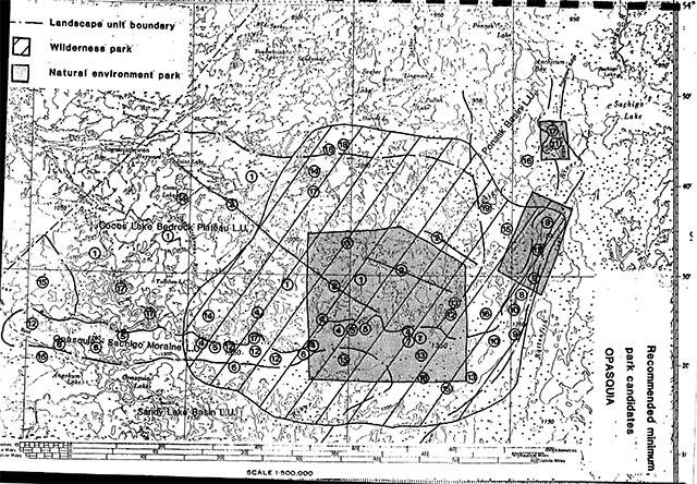
Enlarge map of recommended minimum park candidates - Opasquia (PDF)