Ottertooth Conservation Reserve Management Statement
This document provides policy direction for the protection, development and management of the Ottertooth Conservation Reserve and its resources.
Statement of Conservation Interest
Ministry of Natural Resources
Thunder Bay District
January 2003
Information Management
By Jason Biggar
Thunder Bay District
Approval statement
We are pleased to approve this Statement of Conservation Interest for the Ottertooth Conservation Reserve.
This Statement of Conservation Interest provides guidance for the management of the Conservation Reserve and the basis for the ongoing monitoring activities. More detailed direction is not anticipated at this time. Should significant facility development be considered or complex issues arise requiring additional studies, more defined management direction, or special protection measures, a more detailed Conservation Reserve Management Plan will be prepared with full public consultation.
The public was widely consulted during the designation and regulation of the site and further consultation is not required at this time.
The Conservation Reserve will be managed under the jurisdiction of the Spruce River Armstrong Area Team, Thunder Bay District, of the Ministry of Natural Resources.
Signed by:
W.D. Baker
District Manager
Thunder Bay District
Date: May 29, 2003
Signed by:
Charlie Lauer
Regional Director
Northwest Region
Date: June 27, 2003
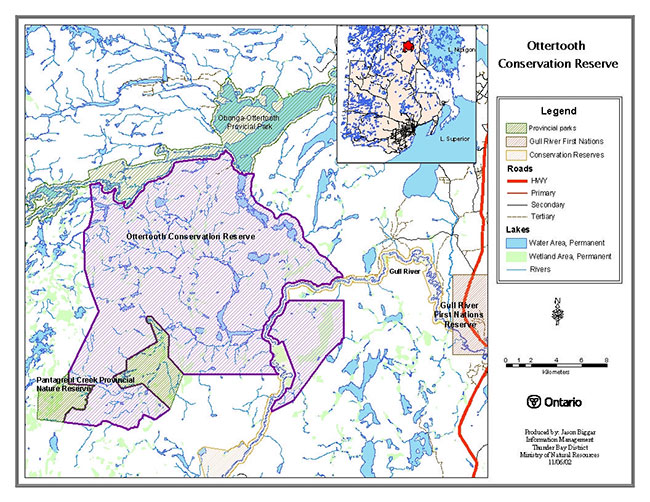
1.0 Map overview
Ottertooth Conservation Reserve overview map
2.0 Background information
The purpose of this document is to identify the natural heritage values of Ottertooth Conservation Reserve, and to protect those values by establishing management guidelines for existing and potential uses in this area given the level of past disturbance and the nature of the existing features. This document provides management direction until more comprehensive planning occurs.
2.1 Background Information
| Name | Ottertooth Conservation Reserve |
|---|---|
| Site Region / Site District | 3W1, 3W2, 3W3 |
| OMNR Administrative Region / District / Area | Northwest Region/Thunder Bay District/ Spruce River Armstrong Area |
| Total Area (ha) | 28,793 hectares |
| Regulation Date | 2003 |
| First Nations | Robinson-Superior Treaty / Gull Bay and Whitesands First Nations |
| OBM | 2016310055100, 2016310055200, 2016320055100, 2016320055200, 2016320055300, 2016330055200 |
| Lat./Long. | 49 49' N/ 89 25' W |
| Basemap | 31551, 31552, 32551, 32552, 32553, 33552 |
| Forest Resource Inventory | 1986 FRI. |
| General Location Description | Ottertooth Conservation Reserve is located approximately 150 km north of Thunder Bay. Ottertooth is located between Gull River Waterway Provincial Park and Obonga-Ottertooth Waterway Provincial Park. Pantagreul Provincial Nature Reserve is located at the southwest corner of the conservation reserve. |
| Access | Ottertooth conservation reserve is remote and difficult to access. The boundary can be reached down Detour Lake Rd., however forest roads have been abandoned and are not passable by vehicle. The only access at this time is by air, or by canoe through Obonga Lake. |
2.2 Representation targets
This section provides a summary of the earth science, life science and cultural values represented in the site. Existing and potential recreational opportunities are also summarized.
| Life science representation | Ottertooth Conservation Reserve is provincially significant based on its "critical" representation of several landform-vegetation types. It has a high diversity of bedrock, terrain, soils and glacial features. A large block of young jack pine dominated forest may provide future habitat for woodland caribou. |
|---|---|
| Earth science representation | This site contains proterozoic bedrock plateaus formed by the Nipigon Sills, which are underlain by Sibley Group sedimentary rocks. Landform features play an essential role in the drainage of meltwater from glaciation, which is part of the Kaiashk Spillway. |
| Cultural Resource Representation | None have been Identified |
| Recreational Opportunities | Hunting, Fishing, and Canoeing |
2.3 Survey information
This section provides an overview of the inventories completed their level of detail, and any further inventories that are needed.
| Survey Level | Completed | Future Requirements |
|---|---|---|
| Life Science | Reconnaissance Level Survey 2001 Northern Bioscience Ltd. | Further inventory for arctic-alpine and rare plants on north facing cliffs. |
| Earth Science | Reconnaissance Level Survey 2001 Northern Bioscence Ltd. | Further earth science inventory is recommended, as its size and features warrant a more in-depth look. |
| Cultural | Consultation undertaken with Ministry of Culture, Recreation and Citizenship (2001) – Bill Ross, Regional Archeologist. | None |
| Recreational | Recreation Resource Inventory May 2002. | None. |
3.0 Values to be protected
This section provides a description of the natural heritage values for the Ottertooth Conservation Reserve and their condition relative to past resource use, management activities and their sensitivity to future land use and management.
3.1 Values identified for protection on the site
3.1.1 Earth science values
The majority of the bedrock within the Ottertooth Conservation Reserve was found to be Proterozoic in age. The bedrock plateaus found throughout this site formed by the Nipigon Sills, which are underlain by Sibley Group sedimentary rocks. Ottertooth Conservation Reserve has very distinct plateau and valley topography, which were formed due to differential weathering of the hard and resistant Nipigon Sills as well as the softer and easily eroded Sibley Group sedimentary rocks.
Several landforms that are found within the Ottertooth site played an important role in the drainage of the meltwater from glaciation. Roughly 9500 years ago the Superior ice lobe receded to expose outlets between Lake Agassiz, Lake Nipigon and Lake Superior. This exposure created an important spillway due to it marking the change in drainage of Lake Agassiz from the south through the Mississippi River to east through the Lake Superior Basin. Evidence of this spillway can be seen along Rabelais Creek where several erosive potholes are located well above its current waterline. Many other glacial features can be found in and around the Ottertooth conservation reserve, such as washboard or ribbed moraines, sinuous esker ridges and proglacial outwash. The features of this site associated with the Kaiashk Spillway are considered provincially significant.
3.1.2 Life science values
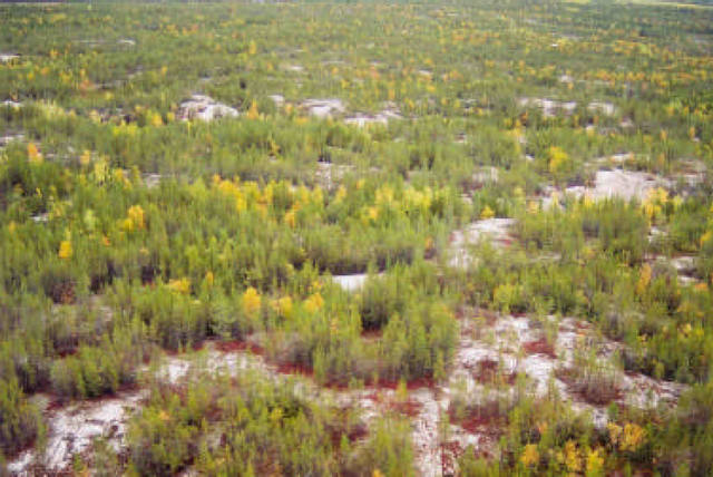
Almost all of the Ottertooth Conservation Reserve (approximately 26, 000 ha) burned in 1980. Today the landscape is dominated by young jack pine and often mixed with trembling aspen and white birch. Pure dense jack pine forest can be found on the sandy outwash areas. This "Sparse Forest" makes up about 75% of the conservation reserve.
Typical landscape
Within the burn boundary of Ottertooth Conservation Reserve, there are patches of mature forest (mostly trembling aspen). Historical evidence of what may have dominated the area in the past and will probably succeed again, for it better suits the site’s conditions. Large unburned areas occur southeast of Osemigwemowin Lake where rugged topography halted the advance of fire.
"Vegetated Bedrock" makes up 10% of the conservation reserve with scattered small jack pine growing from crevices in the bedrock. Small areas of peatland can also be found within the reserve, but makes up only about 2 %.
Very little evidence of human activity was found, although some old logging roads were discovered south of Crevasse Lake on the eastside of Ottertooth Conservation Reserve. Lake Trout anglers enter the conservation reserve at Cooney Lake by portage from Obonga Lake.
Ottertooth Conservation Reserve could provide future woodland caribou habitat as Cladina lichen cover increases and young dense jack pine thin out. Caribou have already been seen 15 km northwest of the conservation reserve.
Many of the cliffs appear similar to those of Ottertooth Lake, which support rare plant species and an extraordinary arctic alpine community. Similar species could be present within Ottertooth Conservation Reserve, given their similar glacial history and bedrock composition.
3.1.3 Recreational values
Historically hunting is a recreational activity that has been taking place in conjunction with a mini-camp and along the perimeter of Ottertooth Conservation Reserve. Moose permits and bear harvesting more specifically have been recorded in this area. Winter recreational use (fishing, snowmobliling) is very light although possible because of the proximity of cottages on nearby Obonga Lake.
Three portages extending from Obonga Lake through to Crevasse Lake help access trout fishing and canoeing opportunities within the site. Recreational values and landforms while unique in this area are not in high demand due to the lack of access and ruggedness of the area.
4.0 Management guidelines
All management activities must conform to the stated intent and direction of this Statement of Conservation Interest. New activities, which do conform, must also be assessed for potential impacts on resource values. Values that have been identified in particular, those noted in sections 3.0, should not be negatively impacted. Management activities are subject to the Environmental Assessment Act.
4.1 Land Tenure
The entire area within and surrounding Ottertooth Conservation Reserve is Crown land. Pantagreul Creek Provincial Nature Reserve delineates some of Ottertooth Conservation Reserve’s boundary to the southwest, while Gull River Conservation Reserve cuts through the southeast corner of Ottertooth Conservation Reserve. The north boundary of Ottertooth is Obonga-Ottertooth Provincial Park. No dispositions (including Land Use Permits, Leases or Licenses of Occupation) will be issued for the site. Sale of Crown lands within the proposed conservation reserve is not permitted.
4.2 Existing and proposed development
Ottertooth Conservation Reserve has no vehicular access. The boundary can be reached down Detour Lake Road, however former forest access roads have been abandoned and are not passable by vehicle or foot. At this time access is limited to canoe from Obonga lake or by air. There are no existing campsites, privies, boat launches, parking lots, authorized trails, or waste disposal sites within the Conservation Reserve.
- New resource access roads are not permitted
- Non-trail use by motorized vehicle will only be permitted for the retrieval of game
4.3 Recreational activities
Recreational activities that have traditionally been enjoyed in this area can continue provided they pose no threat to the natural ecosystems and features protected by the Conservation Reserve. Traditional winter route uses (i.e. ATV and snowmobile use) upon lakes; rivers and portages will be allowed to continue.
- Hunting and fishing activities will continue to be allowed as regulated uses by the Ministry of Natural Resources
- Non-regulated uses (i.e. ATV and snowmobile use) will be permitted as long as they do not adversely affect the values. Effects of recreational use will be monitored on an on-going basis
- Camping is permitted within the Conservation Reserve
4.4 Commercial activities
No other commercial activities such as hydroelectric power development, pipelines, highways or roads and the extraction of aggregate will be permitted. New transmissions lines (e.g. power or communications) are discouraged within the conservation reserve, but is recognized that in some circumstances there will be alternatives; this will be determined through planning.
4.4.1 Forest management activities
The Ottertooth Conservation Reserve is located within both the Kiashke Forest and Black Sturgeon (north block) Forest and will be withdrawn from the Sustainable Forest License.
- Forest Management Activities are not permitted within the Conservation Reserve
4.4.2 Commercial trapping activities
Current trapping activities will be permitted to continue, unless there are significant demonstrated conflicts. Trapline areas are a permitted use and may continue within the conservation reserve.
- There are currently no trapper cabins located within the reserve. No new cabins will be considered
- Repair and replacement of existing cabins are permitted, as long as the scale and function are not significantly altered
4.4.3 Bear management activities
Bear hunting operations may continue in this Conservation Reserve. Bear management areas are a permitted use and may continue within the conservation reserve.
- The transfer of licenses will be permitted on an ongoing basis
4.4.4 Commercial baitfish activities
- New operations may be considered and are subject to a test of compatibility
4.4.5 Mining exploration and aggregate extraction activities
- Mineral exploration and development is not permitted within the Conservation Reserve
- Aggregate extraction is not permitted within the Conservation Reserve
4.4.6 Peat extraction activities
Peat Extraction is not permitted within the Conservation Reserve.
4.5 Aboriginal interests
Ottertooth Conservation Reserve is included in the Robinson-Superior Treaty area and in close proximity to Gull River First Nations Reserve. Trapping is the only known aboriginal interest within the Ottertooth Conservation Reserve, but Gull River First Nations Reserve is so close hunting could be another. This Statement of Conservation Interest in no way affects any existing or future aboriginal or treaty rights.
4.6 Natural Resources Stewardship
Natural Resource Stewardship involves the consideration of the following specific natural resource management categories.
4.6.1 Vegetation
Ottertooth Conservation Reserve is provincially significant based on its "critical" representation of several landform-vegetation types, including sparse forest of pure dense jackpine, some vegetated bedrock, small patches of peatland and a section of rare flora plant species. With the exception to fire, management will allow for the continuation of natural ecosystem processes and functions.
The OMNR recognizes fire as an essential process fundamental to the ecological integrity of this conservation reserve. Forest fire protection will be carried out as on surrounding public lands in accordance with existing conservation reserve policy and the Forest Fire Management Strategy for Ontario. The MNR fire program will endeavor to use "Light on the land" techniques, which do not unduly disturb the landscape, whenever feasible in this conservation reserve. Examples of light on the land techniques may include limiting the use of heavy equipment and foam, and limiting the number of trees felled during fire response efforts. Opportunities for prescribed burning to achieve resource management objectives will be considered. Plans for any prescribed burning will be developed in accordance with the OMNR Prescribed Burn Planning Manual.
Fire is recognized as the primary agent of natural disturbance in this conservation reserve, and may be considered in subsequent planning activities.
- Forest insect and disease management will be addressed on a case by case basis
4.6.2 Fish and wildlife management
Threatened species such as Caribou have been identified adjacent to the boundary of the Conservation Reserve approximately 15 km northwest. Sport hunting and fishing will be allowed to continue within the Conservation Reserve.
- Besides the three cold water and trout fishing lakes, Cooney Lake, Osemigwemowin Lake and Crevasse Lake, no other significant fish resources have been identified in the Conservation Reserve
4.6.3 Landforms
The features of this site associated with the Kaiashk Spillway are considered provincially significant. The bedrock and earth science features associated are resistant to damage by natural process. Existing management guidelines are sufficient to protect landforms that are represented within the Conservation Reserve.
4.7 Client services and marketing
Given the focus on low key management, client information will be given on an inquiry basis only and will deal with basic level of information with respect to access, natural heritage appreciation, recommended activities and boundaries. A fact sheet has been prepared and will be given on an inquiry basis only. The pre-consultation fact sheet is also readily available on the Ministry of Natural Resources Internet Site.
4.8 Research
Non-destructive research related to the inherent values of this site will be encouraged. The rare plant and arctic alpine plant communities may provide some interest for naturalists.
The following outlines areas where more detailed research could be undertaken.
Further earth science inventory should be completed for this site, as its size, complexity and number of significant features warrants a more in-depth investigation than is presented in the earth science report.
Further inventory for arctic alpine plant communities and rare plants should be completed on the north facing cliffs and talus.
All research will require the approval of the Ministry of Natural Resources as will the removal of any natural or cultural specimen. No permanent fixtures on the landscape will be permitted without the approval of the Ministry of Natural Resources. It is the responsibility of the researcher or research group to rehabilitate as closely as possible to its previous state.
5.0 Implementation
These management guidelines are to be implemented by the Spruce River Armstrong Area Team, Thunder Bay District. Any affected clients will be immediately informed of proposed changes to this Statement of Conservation Interest.
5.1 Review and revisions
The Ottertooth Conservation Reserve Statement of Conservation Interest will be reviewed on an ongoing basis.
If changes in management direction are needed at any time, the significance of the changes will be evaluated. Any major amendments will require public consultation and the approval of the District Manager and the Regional Director. This Statement of Conservation Interest complies with all requirements of the Environmental Assessment Act and the Environmental Bill of Rights.
5.2 Public consultation
5.2.1 Results of past consultation
Consultation, related to the regulation of the boundary, occurred for one month from September 20th to October 20th of 2002. Stakeholders contacted during the consultation period included adjacent landowners, claim holders, organizations, tourist operators and outfitters, baitfish harvesters and trappers and relevant provincial ministries. There were no identified concerns or comments about Ottertooth Conservation Reserve.
5.2.2 Aboriginal consultation
Ottertooth Conservation Reserve lies within Robinson-Superior treaty area. Consultation with the Gull Bay and Whitesands First Nations is ongoing.
5.2.3 Future consultation
Future consultation may occur should policies affecting the activities in the Conservation Reserve be changed.
5.2.4 Authors
The Information Management Section, Thunder Bay District, prepared this Statement of Conservation Interest.
6.0 References
Ministry of Natural Resources. Conservation Reserves Policy and Procedure. PL 3.03.05. 1997 Activities/Use policies in Conservation Reserves (April 2000)
Ministry of Natural Resources (2002) NRVIS – Natural Resources Values Information System. Thunder Bay District, Thunder Bay, ON
Ministry of Natural Resources (July 1999) Ontario Living Legacy – Land Use Strategy Queens Printer for Ontario.
Northern Bioscience Ltd. (2002) Earth Science Inventory – Ottertooth Conservation Reserve. Thunder Bay, ON
Northern Bioscience Ltd. (2002) Life Science Inventory – Ottertooth Conservation Reserve. Thunder Bay, ON
Whyte, Pamela, (2002) Ottertooth Conservation Reserve Recreation Resource Inventory, Thunder Bay District, Ontario Ministry of Natural Resources.