Oxtongue River-Ragged Falls Provincial Park Management Plan
This document provides policy direction for the protection, development and management of Oxtongue River-Ragged Falls Provincial Park and its resources.
4279
0-7729-4782- 1
© 1990, Queens Printer for Ontario
Limited copies of this publication are obtainable from:
Ministry of Natural Resources
Bracebridge District Office
P.O. Box 1138
Bracebridge, Ontario
P0B 1C0
Telephone (705) 645-8747
Approval statement
Oxtongue River-Ragged Falls Provincial Park provides access to a diverse riverine landscape from extensive wetlands to rugged upland areas. The scenic and remote High Falls and the rugged Ragged Falls offer visitors spectacular vistas. With rich history reminiscent of the log drives at the turn of the century, the Park now supports significant earth science, life science and historic features, forming a valuable addition to the provincial park system.
We are pleased to approve the Oxtongue River-Ragged Falls Provincial Park Management Plan, as official policy for the management and development of this park. The plan reflects this Ministry’s intent to protect natural and cultural features of the Oxtongue River-Ragged Falls Provincial Park and maintain and develop high quality opportunities for outdoor recreation and heritage appreciation for both residents of Ontario and visitors to the Province.
A.J. Stewart
Regional Director
Algonquin Region
Norm Richards
Director
Parks and Recreational Areas Branch
1.0 Introduction
Oxtongue River-Ragged Falls Provincial Park protects one of Ontario’s significant waterway corridors. The park includes 382 hectares of land and water along the Oxtongue River, extending 6.7 kilometres from the west boundary of Algonquin Provincial Park westward to the site where the river crosses Highway 60.
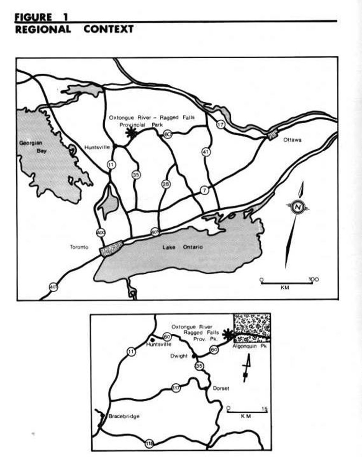
Located within Central Ontario, Oxtongue River-Ragged Falls Provincial Park is approximately 35 kilometres east of the Town of Huntsville along Highway 60. It is approximately 320 kilometres west of the City of Ottawa and 275 kilometres north of the City of Toronto (Figure 1).
The park includes a portion of a scenic canoe route, which begins at Tea Lake in Algonquin Provincial Park and continues down the Oxtongue River, ending in Oxtongue Lake. Two waterfalls are included within the park boundaries: Ragged Falls, which has a vertical drop of approximately 25 metres over a horizontal distance of 200 metres; and High Falls, which has a vertical drop of 10 metres over a horizontal distance of 10 metres.
The area was first recognized for its recreational value during the 1950's. In 1953 and 1959, portions of the planning area, including much of the Crown land surrounding Ragged Falls, were placed under a Crown Reserve. The Ragged Falls Reserve was subsequently considered as a candidate in the perimeter recreation system program for Algonquin Park during the late 1960's and early 1970's. Although this program was later abandoned, there was continued interest in the Ragged Falls area.
In 1983, the Oxtongue River and Ragged Falls viewing area was identified as a candidate Waterway park through the Ministry of Natural Resources Strategic Land Use Planning Program. It was subsequently brought into regulation as a provincial park in 1985 (Ontario Regulation Number 493/85).
Oxtongue River-Ragged Falls Provincial Park lies within the Grenville Province of the Canadian Shield. The river marks the contact between two units or rock types: the biotite gneisses north of the river; and the amphibolite and biotite-horneblende gneisses south of the river.
The Oxtongue River flows through an ancient glacial spillway, which drained meltwaters from the Algonquin Highlands into glacial Lake Algonquin. The river drains southwestward out of Algonquin Provincial Park, cascading over several waterfalls and rapids, including the spectacular Ragged Falls. Three broad physiographic units are identifiable within the park: undulating upland areas covered by a thin, sandy till; glaciofluvial and alluvial deposits associated with the former glacial spillway channel and the present meandering river channel; and extensive organic deposits which have developed in lowland areas.
The vegetative communities of the park are broadly defined by these physiographic units. Sugar Maple (Acer saccharum) dominated forests are, for the most part, associated with the undulating upland areas. Mixtures of beech (Fagus grandtfolia), yellow birch (Betula alleghaniensis) and hemlock (Tsuga canadensis) are common in varying proportions. Hemlock is conspicuous on thin soiled and bare steep slopes and ridges but is also found on deeper water laid sands in close proximity to the river, with balsam fir (Abies balsamea) as an associate. Maple is also found on the well-drained fluvial sands and gravels. Wetland communities dominate the low-lying areas along the river. Thicket communities are typical. The extensive peatland area in the eastern section of the planning area supports black spruce (Pica mariana) dominated swamps and spahagnum moss covered bogs.
The historical features of Oxtongue River-Ragged Falls Provincial Park are a tribute to the ingenuity and determination of those involved in the lumber industry during the late 1800's. The Oxtongue River was once part of the Gilmour Timber Route which was used briefly by the Gilmour Brothers to ship logs from the Canoe Lake area of Algonquin Provincial Park down to the Muskoka and Trent River systems and eventually to their mill in Trenton. Sparse remnants of log chutes and dams are still evident at Ragged Falls and High Falls.
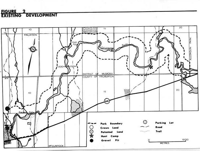
Existing development within the park is limited. A day use area, which includes a parking area, picnic facilities and a viewing area has been developed around Ragged Falls (Figure 2). The park has been managed according to an Interim Park Management Statement, which was prepared in 1985, pending completion of a Park Management Plan.
The Oxtongue River-Ragged Falls Provincial Park Management Plan establishes detailed policy guidelines for the long-term development and management of the park. It considers all known issues and Ministry policies relevant to the park. This plan applies to the twenty year period 1990 to 2010, and provides the opportunity for review at 10 year intervals, or as necessary.
Figure 1: Regional context

Enlarge figure 1: Regional context
Figure 2: Existing development
Enlarge figure 2: Existing development
2.0 Classification
Oxtongue River-Ragged Falls Provincial Park is classified as a Waterway park. Waterway parks incorporate outstanding recreational water routes with representative natural features and historical resources to provide high quality recreational and educational experiences.
In Ontario, provincial parks have been identified and evaluated for their contribution to the Parks System objectives through the Ministry of Natural Resources Strategic Land Use Planning Program. Targets to achieve these objectives have been established for each park in the respective District Land Use Guidelines. Parks are then classified according to the Provincial Parks Classification System, which ensures a permanent, distinctive, representative, varied and accessible system of parks throughout the province.
3.0 Goal
The goal of Oxtongue River-Ragged Falls Provincial Park is to protect the recreational river and its associated natural and cultural features, and to provide a variety of quality outdoor recreational experiences.
4.0 Objectives
Oxtongue River-Ragged Falls Provincial Park will contribute to the four objectives of the Ontario Provincial Park System. The objectives for the park are:
4.1 Protection
To protect significant elements of the natural and cultural landscape of Ontario specifically, life science and historical features of regional significance, and earth science features of local significance.
For park system planning purposes, the Ontario landscape is divided into 65 site districts based on criteria of biological productivity and landforms. The Oxtongue River-Ragged Falls area is situated in Site District 9, the Algonquin Park Site District. The park will contribute to the achievement of the Waterway class target for Site District 9. It also contributes to the achievement of Provincial Park protection targets by protecting life science and historical features of regional significance and earth science features of local significance.
4.2 Recreation
To provide provincial park outdoor recreation opportunities specifically, low intensity day use experiences.
Oxtongue River-Ragged Falls Provincial Park will provide a variety of low intensity recreational opportunities on a seasonal basis. Targets, established in the Bracebridge District Land Use Guidelines, to be provided annually by the year 2000, include 71,000 swimming opportunities, 26,000 picnicking opportunities and 1,000 backcountry opportunities. The park will contribute to the achievement of 1,500 day use and backcountry recreation opportunities annually.
4.3 Heritage appreciation
To provide opportunities for exploration and appreciation of the outdoor natural and cultural heritage of Ontario.
Oxtongue River-Ragged Falls Provincial Park will provide the opportunity for the exploration and appreciation of its natural and cultural resources in an unstructured manner by way of self-use interpretive facilities and information.
4.4 Tourism
To provide Ontario’s residents and out-of-province visitors with opportunities to discover and experience the distinctive regions of the province.
Oxtongue River-Ragged Falls Provincial Park will provide day use and backcountry recreation opportunities to Muskoka and Haliburton area residents, cottagers and the vacationing public. The park will complement existing provincial facilities in the area, including Algonquin Provincial Park and Arrowhead Provincial Park. It will provide an added attraction to assist local area tourism.
5.0 Park boundary
The park boundaries are generally positioned 200 metres in perpendicular distance from the high water mark along the shores of the Oxtongue River. The boundary extends beyond the 200 metre limit at the south west of the park to provide for the day use area at Ragged Falls (Figure 2).
The park does not include four parcels of patented land along the westerly shore of the Oxtongue River at Highway 60. Here, the boundary follows the high water mark of the river adjacent to the patented land. One parcel of patented land, 0.3 hectares in area, is located within the park in Lot 12, Concession I of Finlayson, Township of Lake of Bays.
The Ministry of Natural Resources does not plan to acquire any lands in the park area within the foreseeable future. However, the Ministry would entertain proposals of trade, donations or purchase of properties that would be of significant benefit to the park.
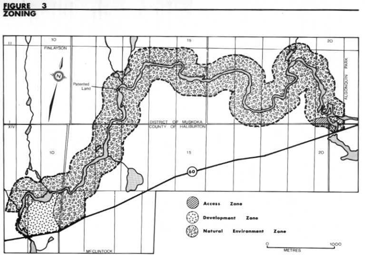
Figure 3: Zoning

6.0 Zoning
The establishment of zones is essential to the orderly development and effective management of the park. Zoning recognizes that every park includes a particular combination of resources, features and potential recreational experiences. It allocates the park’s land base on the basis of the significance for protection and the potential for recreation within the context of the park’s classification. The parks in each class combine zones in a particular way to provide protection and recreation opportunities distinctive to that class. Waterway parks may include Development, Access, Natural Environment, Historical, Nature Reserve and Wilderness Zones.
Oxtongue River-Ragged Falls Provincial Park includes Development, Access and Natural Environment zones (Figure 3).
6.1 Development zone (25 ha)
Development zones provide access to the waterway and accommodate services and facilities for a wide range of recreational activities.
The Development zone is centred around the Ragged Falls Viewing Area. It accesses a very popular and attractive waterfall feature and provides day use facilities accessory to this feature including a parking area, a picnic area, a minor trail system and viewing area.
6.2 Access zone (4 ha)
Access zones serve as staging areas where minimum facilities support the use of less developed portions of the water route.
The Access zone will provide access to the Oxtongue River from the east boundary of the park for visitors who wish to travel the length of the park. Facilities will be limited to an access road, parking area and launching area for canoes and small boats.
6.3 Natural environment zone (353 ha)
Natural Environment zones include aesthetic sections of the river corridor in which minimum development would be required to support low intensity recreational water travel activities.
The majority of the park will be zoned Natural Environment. This zone includes much of the highly irregular topography of the western section of the park. Here, tolerant coniferous forests of eastern hemlock and white cedar (Thuja occidentalis) dominate the ravine slopes and wet depressions, whereas the highland supports tolerant deciduous and mixed forests of sugar maple, eastern hemlock, and yellow birch in rich, sandy loam soils. The extensive wetland area of the eastern section of the zone supports a lowland bog forest of black spruce surrounded with balsam fir.
Ragged Falls and High Falls are notable not only for their scenic value, but also for their historic value. There are sparse remains of log chutes and darns at both sites that are reminiscent of the log drives down the Oxtongue River at the turn of the century.
The extensive wetland complex contains a variety of interesting flora and fauna. Although considered typical for the Site District, it is by its nature sensitive to development.
These features are not considered to require distinctive management efforts. However, to maintain the existing aesthetic values of these features, recreational development in this zone will be restricted to facilities associated with backcountry recreation.
7.0 Resource management policies
7.1 Vegetation
Vegetation will be managed to complement aesthetic values, wildlife habitat and interpretation efforts while providing for safe and enjoyable recreational uses, in accordance with the planning policies for Waterway parks. A vegetation management plan may be prepared if the need arises.
Commercial forest operations will not be permitted in the park. Trees removed for development and management purposes may be marketed or used for park purposes.
Non-native plant species will not be deliberately introduced. Fertilizers may not be used except in the Development zone and Access zone.
All forest fires will be suppressed. The fire suppression techniques used will have as minimum an effect as possible on the environment. Techniques such as bulldozing and water bombing with chemical additives will not generally be permitted except in critical situations as determined by the Park Superintendent or District Manager in cooperation with the Regional Fire Coordinator.
Fire protection is provided by the Ministry’s Bracebridge District. The park is included in the intensive Protection Zone 2B of the Bracebridge District Wild Fire Prevention Plan. This zone includes areas of high value, low hazard and low risk.
Insects and diseases threatening park values will be controlled where feasible. Where control is desirable, it will be directed as narrowly as possible to the specific pest so as to have minimal effect on other components of the park’s environment. Biological control will be used whenever feasible.
7.2 Fisheries
Sport fishing is permitted in Oxtongue River-Ragged Falls Provincial Park. The Oxtongue River will be managed as ~ marginal, self-sustaining brook trout fishery in accordance with the Bracebridge District Fisheries Management Plan.
7.3 Wildlife
Animal populations may be controlled when essential to protect human health and safety or the health of the species inside or outside the park. Where control is desirable, techniques will be used having minimal effects on other components of the park’s environment. Control measures will be carried out under the supervision of, or directly by, the Ministry of Natural Resources.
Non-native animal species will not be introduced into the park.
7.3.1 Sport hunting
In Oxtongue River-Ragged Falls Provincial Park hunting will be permitted only in the Natural Environment zone.
7.3.2 Hunt camps
The hunt camp in Oxtongue River-Ragged Falls Provincial Park will be phased out over a twenty-one year period, effective January 1, 1989.
No new hunt camps will be authorized within the park. A Land Use Permit will be issued on an annual basis, subject to compliance with the conditions of the permit, for the hunt camp located in Lot 18, Concession I of Finlayson, Township of Lake of Bays, to and including the year 2010.
7.3.3 Commercial trapping
Commercial trapping will be phased out of Oxtongue River-Ragged Falls Provincial Park over a twenty-one year period, effective January 1,1989, or when the two currently registered trappers cease operation.
No new traplines will be established within the park. A Letter of Permission will be issued annually, to the current registered trappers of trapline BR 05 N018 and BR 02 1341 for use of those areas within the park boundaries, up to and including the year 2010.
7.4 Landforms
7.4.1 Minerals and mineral aggregates
The exploration or extraction of minerals or aggregates will not be permitted within the park. Where aggregate is required for development, maintenance or improvement of park facilities, it will be imported from external sources.
7.4.2 Water resources and control
Water control structures such as dams or dykes will not be permitted in the park. Water levels in the park will continue to be monitored and controlled by a dam at Tea Lake.
8.0 Operations policies
A Park Operating Plan will be prepared to provide park staff with the necessary information required to operate the park on a day-to-day basis. In addition to addressing the operations policies, which follow, the plan will include such topics as budgeting, staffing, maintenance schedules, enforcement and emergency services. The provisions of the plan will be consistent with the approved Ontario Provincial Operating Standards, and will be reviewed annually and updated as required.
8.1 Visitor services
Oxtongue River-Ragged Falls Provincial Park will offer a self-use level Activity Visitor Services Program. Major facilities will not be provided. However, personal exploration of the park and the surrounding area will be encouraged using a self-guided approach.
8.1.1 Information
A high quality public information service using print and display material will be developed. This service will highlight the park and the surrounding by providing information on significant natural and cultural features, park facilities, recreational opportunities, river travel, and safety tips and park user ethics. The service will be centred in the Development zone at the Ragged Falls Viewing Area and will include a park map, display board and brochure.
8.1.2 Interpretation
The interpretive program for Oxtongue River-Ragged Falls Provincial Park will provide visitors with the opportunity to learn about and discover the area’s unique natural and cultural heritage. Interpretive themes will include:
- the historical expeditions of early explorers including Lieutenant Henry Briscoe, Alexander Shirreff, and David Thompson
- the historical use of the Oxtongue River for log driving, including the construction and use of the Gilmour Tramway, the Gilmour Mill at Canoe Lake, water control and logging in and around Tea Lake, and the subsequent use of the river by other lumber companies, notably Mickle and Dyment and D. Shier
- the earth and life science features of the park; and
- the role of the park in Ontario’s Park System
The interpretive program will encourage individual and unstructured exploration of the park. The brochure and display board will focus on the interpretive themes and provide the medium for expressing the message of the interpretive program.
8.1.3 Recreation
Oxtongue River-Ragged Falls Provincial Park will offer excellent opportunities for picnicking and other day use activities at the Ragged Falls Viewing Area. The river provides an interesting and varied boating experience for the recreational boater or canoeist.
8.2 Research
Research by qualified individuals, which contributes to the knowledge of our natural and cultural history and to the environmental and recreational management of our waterways, will be encouraged in the park.
All research programs will require prior written approval of the Ministry of Natural Resources and must also meet all requirements under applicable provincial and federal legislation. Approved research activities and facilities will be compatible with the protection values and the recreational uses of the park, and will be subject to the development and management policies detail herein, unless special permission is otherwise granted.
8.3 Recreation management
To ensure the continued high level of service offered at the park, a regular grounds maintenance program will continue. This will include garbage pickup, cleaning of sanitary facilities, annual removal of hazard trees, and grading of the access road and parking lot.
In the past, the Ragged Falls Viewing Area has experienced minor visitor related problems, such as over-use of the trail network and minor vandalism of the rock face. These problems have been recognized and management strategies, such as adding woodchips to the trail system, have been put in place. The present program to monitor and manage these facilities will be continued.
Motor vehicles or all-terrain vehicles as defined in the Provincial Parks Act, will be permitted in the park only on designated roads, except where required for park management purposes and except where stated in Section 9.1 of this Plan.
Snowmobiles will be permitted on the western access road through the gravel pit and on the access road and trail leading to Ragged Falls.
8.4 Marketing
In order to realize the recreation potential of Oxtongue River-Ragged Falls Provincial Park and complement the local tourist economy, a Marketing Strategy will be prepared for the park. The strategy will include the following objectives: to attract day visitors staying at local commercial establishments or nearby provincial parks; to attract day visitors from local urban centres and private cottages; to attract visitors during low use periods in the mid-week and the shoulder seasons; to increase involvement with the commercial sector by encouraging park visitors to use local services and facilities; and to generally stimulate interaction between the park and the private tourist and commercial sector in the vicinity.
9.0 Development policies
New development within the park will be minimal and consistent with the goals and objectives of a Waterway class park. Existing facilities will be maintained, and where deemed necessary, upgraded to maintain a high quality recreational experience.
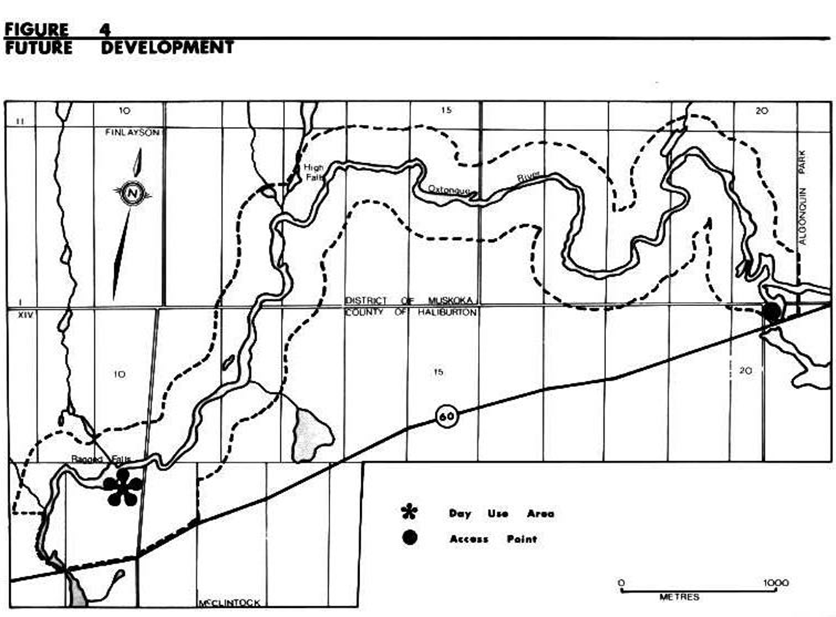
Development will proceed in accordance with Figure 4 and the following guidelines. In all instances, detailed site plans will be completed and approved in advance of renovation of existing facilities or development of new facilities. Development projects will be phased in according to the priorities established in Section 10.0, Implementation Strategy. A demonstrated need and the availability of funds will determine the exact timing of development.
All development will adhere to the requirements of the Environmental Assessment Act.
9.1 Access and parking
One minor access point will be constructed within the park in the Access zone.
Development of the Access zone will include an access road from Highway 60 at a location approved by the Ministry of Transportation, parking facilities with a total capacity for ten cars, privies and garbage disposal facilities. Boat launching facilities at the site will be minimal to encourage the use of canoes and small engine motor boats.
The access road and parking facilities at the Ragged Falls Viewing Area will be maintained at their present level of service, providing parking spaces for twenty cars.
Further to Section 8.3 of this plan, the following provisions will apply to the use of all other roads within Oxtongue River Ragged Falls Provincial Park.
- Forest access roads will not be permitted
- The western access road through the gravel pit - the road will remain open for public use by motor vehicles
- The trail immediately east of the access road to Ragged Falls - use of the trail by all-terrain vehicles for the purpose of boat launching and removal will be permitted during the deer and moose season only. Permission will be granted by an annual Letter of Permission from the Park Superintendent to hunt camp members
- The road to the private parcel, Lot 12, Concession I, Finlayson, Township of Lake of Bays - use of the road by motor vehicles, by the owners of the private parcel or their guests will be permitted
- The road to the Oxtongue River Hunt Club and to the north side of Oxtongue River - public use of the road will be permitted from October 1st to and including November Use of the road by the registered trappers of trapline BR 05 NO18 and BR 02 1341 will be authorized annually by a Letter of Permission
- All other uses of roads within the park will occur only with the written permission of the Park Suerintendent
9.2 Day use area
Facilities at the Ragged Falls Viewing Area will be maintained at their present level of service. Consideration may be given to an expansion of the picnic facilities should the need arise in the future. This need will be based upon the overall level of use, substantiated by demand indicators such as general requests and use surveys.
A small dock will be installed at the base of Ragged Falls to assist canoeists in departing and landing. The dock will be situated at an inconspicuous site so as not to interfere with viewing opportunities from the top of the falls.
A sign, which identifies Oxtongue River-Ragged Falls Provincial Park will be designed and situated at the highway entrance to the Ragged Falls Viewing Area.
An information display area will be developed at the day use area to provide visitors with information on the park and its features.
9.3 Facilities for park administration and operation
The park administration facilities will not be located on site. Staff, centred at Arrowhead Provincial Park, will plan routine visits to Oxtongue River-Ragged Falls Provincial Park to ensure the orderly operation and maintenance of the park and its recreational facilities.
10.0 Implementation priorities
The management plan will be reviewed every ten years following its approval or as the need arises. Data collection and environmental monitoring will be conducted regularly. The following is a list of projects that have been identified in this plan. The list appears in chronological order according to the individual project priority. The completion of projects will depend on the availability of necessary funding and as increased recreational use warrants.
Priority rating project description
| Priority Rating | Project Description |
|---|---|
| 1 | Develop Site Plans for proposed facilities at the Development and Access zones |
| 2 | Develop and upgrade the Development zone |
| a) upgrade parking lot and sanitary facilities | |
| b) design and position park sign | |
| c) construct canoe dock at base of Ragged Falls | |
| d) develop visitor information service, including display board and park brochure | |
| 3 | Develop a Park Operating Plan |
| 4 | Develop the Access zone |
| a) construct new access road and parking lot | |
| b) provide basic boat launching facilities | |
| c) provide privies and garbage disposal system d) design and position sign | |
| 5 | Develop a Marketing Strategy |
Figure 4: Future development

Enlarge figure 4: Future development
11.0 Public consultation
The park management planning process was initiated in November of 1988. Public notification of the process was given, at that time, in the local newspapers.
In January of 1989, a report which compiles the background information for the park was made available to the public. A newsletter summarizing this information and requesting public comment was distributed to all those on the park’s mailing list. The general public was notified by advertisements in local newspapers.
The Preliminary Management Plan was made available to the public in early April, 1989. A second newsletter, summarizing the plan and inviting the public to discuss the plan with the Planning Committee at an Open House, was distributed to all those on the park’s mailing list. The general public was notified by a news release and advertisements placed in local newspapers. The Acting Parks Supervisor was interviewed by a local radio station and the Parks Superintendent was interviewed by a local television station. The Open House was held April 28 and 29, 1989 in the Town of Huntsville.
Most participants were in general agreement with the Preliminary Management Plan. Concern was expressed by area hunters over restrictions on traditional hunting areas and access to traditional hunting areas. Detailed provisions w ere then added to permit controlled use by motor vehicles on existing roads and trails within the park as detailed in Section 9.1.
The concerns identified through public consultation are discussed in detail in a report 'Oxtongue River-Ragged Falls Provincial Park, Park Management Plan, Summary of Public Response'. This report and copies of all public input are available for review at the Bracebridge District Office.
The Park Management Plan for Oxtongue River-Ragged Falls Provincial Park is a refinement of the Preliminary Park Management Plan. It addresses the issues raised through public consultation and resolves these issues within the context of applicable legislation, Ministry policies and sound resource management principles.
12.0 References
Brunton, D.F. Life Science Areas of Natural and Scientific Interest in Site District 54. Unpublished Report, Parks and Recreational Areas Section, O.M.N.R., Algonquin Region, Huntsville, 1989.
Edwards, R. Historical Resource Inventory of Ragged Falls Reserve, Volume 1, Unpublished Report, O.M.N.R., Parks and Recreational Areas Branch, Algonquin Region, Huntsville, 1975.
Environment Canada. Canadian Climate Normals 1951-1980 Atmospheric Environment Service, Canadian Climate Program, Ottawa, 1980.
Hills, G.A. A Ready Reference to the Description of the Land of Ontario and its Productivity, Ontario Department of Lands and Forests, Division of Research, Maple, 1959.
Martin, P. Oxtongue River-Ragged Falls Provincial Park, Compilation of Background Information Unpublished Report, O.M.N.R., Bracebridge District, 1989.
Ontario Ministry of Natural Resources. Access Guidelines Management Area 'C', Bracebridge District , Unpublished Report, Bracebridge District, 1985.
Ontario Ministry of Natural Resources. Backgrounder. Land Use Guidelines , Toronto, 1983.
Ontario Ministry of Natural Resources. Braacebridge District Fisheries Management Plan. 1986-2000, Queen’s Printer for Ontario, Queen’s Park, 1988.
Ontario Ministry of Natural Resources. Bracebridge District Land Use Guidelines, Lands Branch, Algonquin Region, 1983.
Ontario Ministry of Natural Resources. Earth Science Checksheets for Bracebridge District Parks, Park Reserves and Proposals Parks and Recreation Areas Branch, Algonquin Region, 1979.
Ontario Ministry of Natural Resources. Life Science Checksheets for Bracebridge District Parks, Park Reserves and Proposals , Parks and Recreation Areas Branch, Algonquin Region, 1979, revised 1983.
Ontario Ministry of Natural Resources. Ontario Provincial Parks Management Planning Reference, Parks and Recreation Areas Branch, Toronto, 1988.
Ontario Ministry of Natural Resources. Ontario Provincial Parks Planning and Management Policies Parks and Recreation Areas Branch, Toronto, 1978.
Ross W., and D. Ragged Falls Area, Archaeological Resource Inventory, Unpublished Report, O.M.N.R., Parks and Recreation Areas Branch, Algonquin Region, 1975.
Rowe, J.S. Forest Regions of Canada, Bulletin No. 123, Department of Northern Affairs and National Resources, Forestry Branch, Ottawa, 1959.
Showkewych-Hanna, R. Preliminary Botanical Inventory of the Ragged Falls Study Area, Environmental Planning Series VI, 20, O.M.N.R., Parks Planning Branch, Toronto, 1976.
4279
(0.25 k P.R., 90 5 11)
ISBN 0-7729-4782-1