Pancake Bay Provincial Park Management Plan
This document provides policy direction for the protection, development and management of Pancake Bay Provincial Park and its resources.
Ontario Ministry of Natural Resources
© 1988 Queen’s Printer for Ontario
Single copies of this publication can be obtained from the Ontario Ministry of Natural Resources, Sault Ste. Marie District Office, P.O. Box 130, 875 Queen Street East, Sault Ste. Marie, Ontario P6A 5L5, Telephone: (705) 949-1231.
ISBN 0-7729-2091-5
Approval statement
We are pleased to approve this management plan for Pancake Bay Provincial Park. It establishes policy for the future management, development and use of Pancake Bay Provincial Park. It provides an understanding of the present situation of the park, why changes are necessary, and the specific changes that will be made.
M. A. Klugman
Regional Director
Northeastern Region
Norm R. Richards
Director
Parks and Recreation Areas Branch
1. Introduction
Pancake Bay Provincial Park is located on the eastern shore of Lake Superior, 78 kilometres north of Sault Ste. Marie on Highway 17 (figure 1). The Park was first operated in 1958 and officially became a Provincial Park by Ontario Regulation in 1968.
The 490 hectare park, 230 hectares of which is the bed of Pancake Bay, contains a variety of features associated with the melting of ancient glacial ice-sheets and subsequent readjustment of the Lake Superior water levels.
Classified as a Recreation Park, Pancake Bay caters to family oriented recreation by providing an attractive natural setting for camping, swimming, fishing, cycling, hiking, and children’s play areas.
Pancake Bay lies within the northern part of the Great Lakes-St. Lawrence Forest Region. An interesting mix of vegetation is found within the Park, with many species at their northern limits. The forests are primarily deciduous, with sugar maple and yellow birch dominating. The beach and back-beach areas are home to rare and sensitive plant species.
The 3.5 kilometre sandy beach is one of the best on Lake Superior. The cool waters of Lake Superior (maximum water temperature of 19 degrees Celsius, July-August) provide a refreshing swimming experience, and the wide expanse of beach is an excellent site for other recreational pursuits.
It was this beach that attracted voyageurs to the area as they canoed across Lake Superior in the 1700's and 1800's. The name Pancake Bay is derived from folk stories that told of voyageurs preparing batches of pancakes from their remaining provisions as they traveled from this area to Sault Ste. Marie.
Pancake Bay Provincial Park contains 338 campsites; 69 have electrical hookups. Six group camping sites are capable of serving 250 campers, and a picnic area has parking for 130 vehicles.
There are 56 vault privies with hand basins and a comfort station with shower facilities, flush toilets, and hand basins. A children’s fish pond, a recreation play area, a 3.5 kilometre nature trail and an amphitheatre comprise the remaining recreational facilities.
2. Classification
Pancake Bay Provincial Park has been classified as a Recreational Park within the system of Provincial Parks because of its natural setting and proximity to Highway 17, a major recreation and tourism travel route. The area has traditionally attracted local campers from the cities of Sault Ste. Marie Ontario and Michigan, as well as highway travellers enroute to other destinations.
In accordance with Provincial Parks Planning and Management Policies (1978), as approved by Cabinet, the Park can "support a wide variety of outdoor recreation opportunities for large numbers of people in attractive surroundings" .
Even though the Park may be small in total area when compared to other Provincial Parks, it does contain a unique portion of Lake Superior shoreline. The focal point is its outstanding beach and characteristic backshore progressing from small grass covered dunes to mixed forest.
Figure 1- Regional Setting
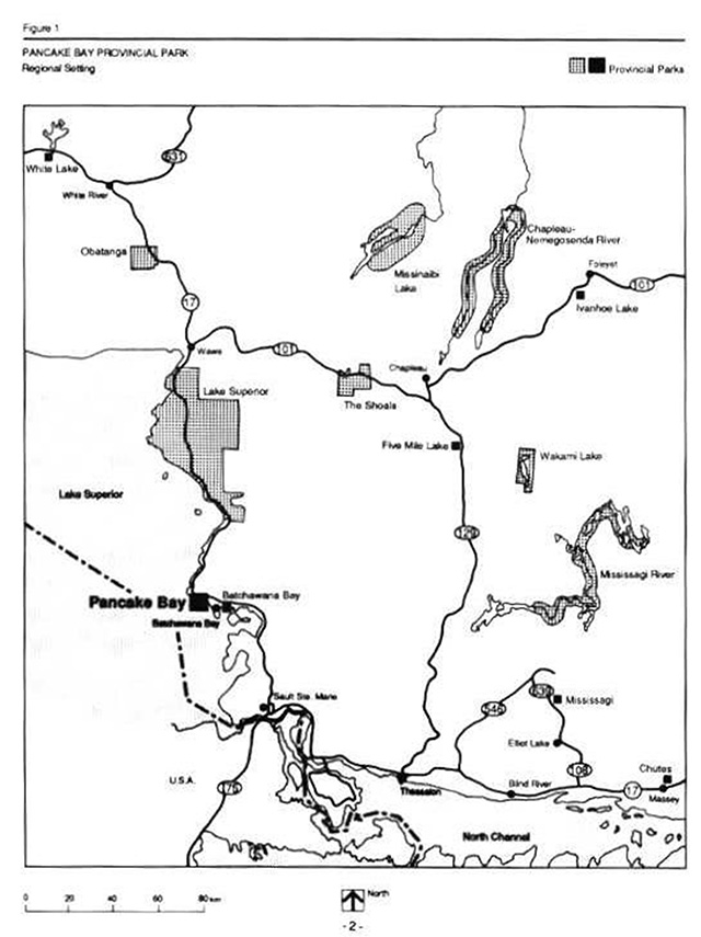
Enlarge figure 1- Regional setting
3. Goal
Pancake Bay Provincial Park - can support a wide variety of outdoor recreation opportunities for large numbers of people, in an attractive mixed forest beach setting, of Lake Superior shoreline. The Park’s day use area and campground flank one of the most extensive sand beaches on this inland sea.
4. Objectives
All four provincial objectives as described in the Provincial Parks Policy (1978) will be achieved: recreation; heritage appreciation; tourism; and, protection.
4.1 Recreation
The recreation objective is… "To provide outdoor recreation opportunities ranging from high Intensify day use to low intensity wilderness experiences."
Pancake Bay Provincial Park, with its small land base, is not capable of contributing to wilderness recreation experiences. The Park will continue to provide approximately 96,300 car camping and 33,000 day use opportunities as described in the Sault Ste. Marie District Land Use Guidelines (1983).
There is a need, however, to expand some existing facilities, including day hiking and children’s play areas to provide more services for Park visitors.
4.2 Heritage appreciation
The heritage appreciation objective is… "To provide opportunities for exploration and appreciation of the outdoor natural and cultural heritage of Ontario."
Pancake Bay Provincial Park offers opportunities for visitors to learn about the area’s natural and cultural heritage including eastern Lake Superior geology and ecology, Great Lakes transportation, Native occupations, the fur trade, commercial fishing, timber harvesting and mining. These heritage themes will be presented through self-guided trails, outdoor displays, literature, and the Park host program for day use and campground visitors.
Heritage appreciation initiatives in areas adjoining the Park and features accessible north and south of the Park on Highway 17 could be pursued within the wider objective of tourism.
4.3 Tourism
The tourism objective is… "To provide Ontario’s residents and out-of-province visitors with the opportunity to discover and experience the distinctive regions of Ontario."
Pancake Bay Provincial Park receives the majority of its use from tourists traveling the Highway 17 route along Lake Superior. This type of use is expected to continue. Promotion of park resources and facilities and adjacent area attractions will enhance the tourism potential of this area.
A good portion of Park visitors are highly mobile, as expressed in their short length of stay. Thus, through literature and information from staff, tourists will be informed about areas of interest accessible from Highway 17 north and south of the Park (e.g. Mamainse fishery, Alona Bay Lookout, Lake Superior Provincial Park Pictographs, Sault Ste. Marie, Algoma Art Gallery, Sault Locks, etc.).
4.4 Protection
The protection objective is… "To protect provincially significant elements of the natural and cultural landscape of Ontario."
The Park contains a variety of landscape elements significant to this part of Ontario. Protection of the sensitive beach and back-beach environment is paramount, particularly in light of the intensive recreational use in this portion of the Park. The ancient beach and riverine features of the area also warrant protection.
Zoning policies and resource management measures will be taken to ensure protection of these features.
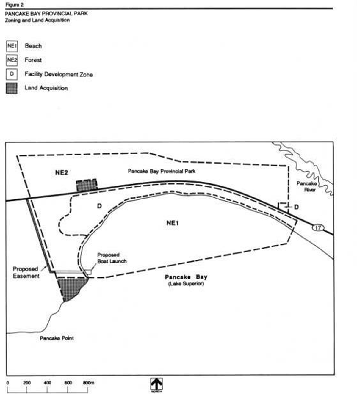
5. Park zoning
Pancake Bay Provincial Park has been divided into one development zone and two natural environment zones (figure 2).
5.1 Facility development zone
D - Camping, day use and administration
This zone contains all camping areas, day use area, the park entrance, the internal road system and the administrative facilities.
The major portion of the zone will be oriented towards intensive recreation and will also contain children’s play areas, the fish pond and the amphitheatre. Day use recreation will be focused through a separate parking area east of the gatehouse to minimize traffic congestion in the campsites to the west.
Park operations administration (warehousing, office, staffing and roads) will occur separate from public recreational facilities.
5.2 Natural Environment Zones
NE1 - The Beach
This zone includes the offshore area, 3.5 kilometres of sand beach and the back-beach. The boundary between this zone and the D zone is the line of forest vegetation surrounding the southernmost campsites along the beach and/or the campground road and the day use area.
Recreational use in this zone will be restricted to water oriented activities such as boating, swimming and sunbathing. No additional permanent buildings will be permitted in this area. Although foot bridges and erosion control structures will be considered, access through the beach/dune grass areas will be controlled where necessary.
NE2 - The Forest
The majority of the forested portion of the Park is within this zone. Recreational activities will be restricted primarily to hiking and nature appreciation. There will be no permanent structures or development other than those associated with the trails.
To the north of Highway 17, the existing park gravel pit and microwave tower access road will remain. The only long-term development features of this area will be to provide day use walking trails and related facilities (e.g. interpretive displays, sanitary facilities, parking).
Figure 2- Park zoning and acquisition
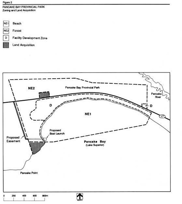
Enlarge figure 2 - Park zoning and acquisition
6. Resource management
Resource management of Pancake Bay Provincial Park will be carried out in accordance with the park management plan. A park operating plan will be prepared. The operating plan will comprise specific operational guidelines on how to carry out the management of the Park’s vegetation, fisheries and landforms.
6.1 Vegetation
A variety of vegetation resources exist within the Park, ranging from sensitive and rare beach/dune grasses to mature coniferous and deciduous forests. The natural vegetation is an important component of the recreational experience, but in many instances a concerted effort is required to ensure its long-term health and maintenance.
Within the development zone and along trails, vegetation will be thinned and pruned around existing facilities, roadways and campsites to increase or preserve aesthetics and to reduce hazardous situations. Stressed, wind thrown or hazard trees will be removed as required. Diseased trees will not normally be treated, unless significant widespread damage to the forest resource is anticipated. In such cases, a plan for treatment will be developed. The planting of trees within the development zone will be continued where required for aesthetic, landscaping or erosion protection purposes. Vegetation around campsites, trails and recreational areas will be monitored to determine if vegetation rehabilitation efforts are required to correct compaction, erosion or over-use problems. A detailed examination of the sensitive beach and back-beach plant community will be undertaken. Educational and passive restraining methods to reduce erosion by foot traffic will concentrate on diverting use around or away from the most susceptible areas.
Due to the importance of the vegetation resource to Pancake Bay Provincial Park, a vegetation management plan will be prepared to further define and coordinate the implementation of the above strategies.
6.2 Wildlife
Due to the small land base and intensive development, hunting is not permitted in Pancake Bay Provincial Park. Trapping is also not permitted, except under the direction of the Ministry of Natural Resources for the removal of nuisance animals.
6.3 Fisheries
Fishing is not normally an important recreational use within the Park. During the spring and fall, however, some anglers gain access through the Park to launch boats in Lake Superior. Some spring and fall angling occurs around the mouth of Black Creek, inside the Park. Presently, commercial fishing in the Lake Superior portion of the Park is not permitted from June 1 to September 9. No commercial fishing is permitted at any time within one kilometre of Pancake River or Black Creek.
The children’s fish pond is a popular recreational site within the Park. Although fish stocks have been obtained annually for planting in the pond, there has been no long-term commitment for annual supplies of fish stock.
Annual fish planting requirements (species and numbers) will be evaluated and secured for the children’s fish pond on an annual basis as a put and take fishery.
6.4 Landforms
Higher than normal Lake Superior water levels in recent years and storm waves have resulted in increased natural erosion along some sections of the shoreline. Loss of park property, trees and possible threats to some facilities may result over the long-term.
The extent of existing and potential erosion along Lake Superior within the Park will be evaluated to establish a course of action to address erosion. The study will address what action, if any, is required to reduce the effects of erosion on the beach environment and facilities.
6.5 Land acquisition
Three parcels of land have been reviewed for acquisition (figure 2).
A small parcel of land on the north side of Highway 17 is the site of an abandoned gravel pit owned by the Ministry of Transportation and Communications.
The Park will, as funds and priorities permit, acquire this abandoned gravel pit to ensure that no incompatible developments occur which may affect the Park.
A parcel of land situated on the east side of Pancake Point, south of the Park boundary, has some potential for use. The site contains some interesting landforms not represented In the Park and is presently used informally by Park visitors for hiking. The parcel is landlocked and if private development occurred, it might conflict with Park use and management.
The Park will, as funds and priorities permit, acquire this triangular parcel of land.
A right-of-way along the west boundary of the Park will be required to provide access directly from Highway 17 to a proposed boat launch facility. Negotiations for this strip of land will proceed in conjunction with the development of the boat launch.
7. Visitor services
Visitor services will be managed in accordance with this park management plan. A visitor services plan and park operating strategy will be prepared in keeping with the direction provided in the management plan. These plans will provide specific operational guidelines on how to carry out visitor services programs.
The Park and area themes will be highlighted primarily through self-use information and facilities.
Themes of the Park include:
- area geology in features portraying ancient environments associated with metamorphic and volcanic rocks of the Superior Geological Province
- geomorphological - features represented in this portion of the ancestral and modern eastern shores of Lake Superior
- mineral and surficial geology explorations and small scale mining
- plant and animal communities typical of transition Great Lakes - St. Lawrence and Boreal forests
- fur trade/voyageur travel
- timber harvesting and transportation
- commercial fishing and settlement; and
- conservation and family camping/day use
7.1 Communications
In a recent camper survey (1984), it was found that 22% of campers consider the Park to be one of a series of destinations on their holiday along Highway 17. Promotions like the Superior Circle Tour feature the Park. Many campers use the Park as a single night stopover enroute to another primary destination (52%). The majority of campers staying for two or more nights are regular visitors from Sault Ste. Marie or the surrounding area.
In the 1984 camper survey, a large percentage of people interviewed did not know what services were available in the Park for Interpretation and recreation programming. This reflects visitors' short length of stay and a lack of contact with visitors. Relaxation and swimming were the most frequently mentioned activities preferred by visitors.
With an emphasis on self use and some program activities, campers and day visitors will be given more information on Park themes and area attractions. Programmed activities will include the host and hostess contacts with visitors guest speakers and special events. The amphitheatre facility is useful as a focal point and an effective approach to this programming.
7.2 Interpretation and outdoor recreation
With the emphasis on self use visitor services, the programming will rely on publications, the existing Park trail and outdoor displays to represent Park and area themes.
The existing nature trail (3 kilometres) and its self-conducted trail guide will be maintained.
The day use area will be evaluated to determine the best approach to providing day visitors with interpretation related to fur trade/voyageur travel and other area cultural and natural history themes. The potential to offer a longer day use hiking trail adjacent to the Park will be evaluated.
Publications produced by other agencies concerning area attractions which are related to the Park themes will be available In the Park.
Similarly, opportunities to provide interpretation and outdoor recreation programming will be pursued through the host and hostess activity, guest speakers and special events.
7.3 Marketing
The park marketing plan (1980) will be updated, taking direction from the Park’s tourism, recreation and heritage appreciation objectives.
A first priority will be to hold existing visitors. Also, there will be an emphasis on increasing shoulder season use by informing potential visitors of the attractions and facilities found in this area of eastern Lake Superior.
The attributes of convenient access, the extensive sheltered beach and the modern campground services will be the main aspects in promoting its use.
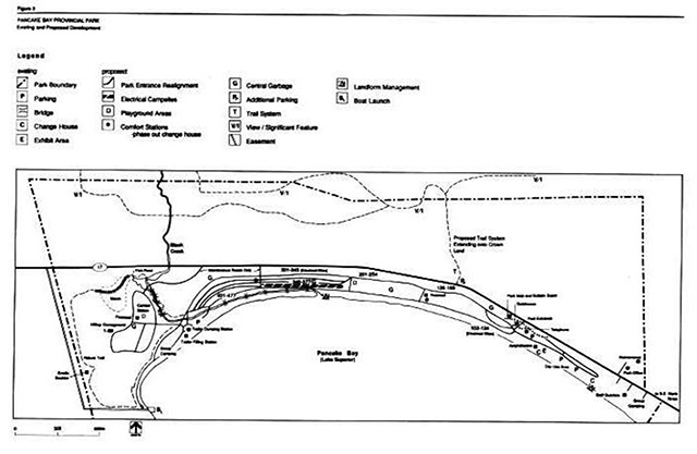
8. Development
Pancake Bay Provincial Park has been developed for a considerable time and with the exception of two new comfort stations, there is little demand for major new facilities. The redevelopment and operation of the Park will be improved by phasing out redundant structures, and revising sanitation and safety procedures. Overall maintenance costs will be reduced by facility improvement (figure 3).
Park developments described in this section will be carried out according to approved site and development planning. Once in place, upgraded or new facilities will be managed through the park operating strategy. Implementation will proceed according to work program planning and special funding initiatives.
8.1 Access
The existing entrance provides a limited parking/waiting buffer for vehicle registration. Congestion regularly occurs during the late afternoon and early evening when the majority of travelers enter the Park. Traffic waiting in the turning lanes on Highway 17 often constitutes a considerable hazard to other highway traffic.
During peak registration periods, additional staff will be used to hasten registrations and control traffic flow. Over the long-term, the Park entrance will be redesigned to allow for a safer entrance to the gatehouse.
8.2 Sanitation services
Park visitors regularly identify the need for additional shower facilities. The Park is presently serviced by one comfort station at the west end, and 56 vault privies dispersed throughout the developed area. Bathing (washing) in Lake Superior is neither desirable nor practical. In addition, odour problems periodically occur with vault privies.
Two additional comfort stations will be developed within the main camping area. They will contain flush toilets and shower facilities. In addition, they will be designed to accommodate laundry facilities, which may be installed in the future, depending on the results of a survey to determine the impact on privately-owned facilities presently in the area. The number of vault toilets will be reduced once the new comfort stations are in place. Improvement of ventilation in the vault privies will continue.
Vault privies and the existing comfort station are not constructed for the convenience of the handicapped. This will be corrected in order that the handicapped can take full advantage of essential Park facilities. The new comfort stations will have proper access and facilities for handicapped persons.
8.3 Electrical services
Only 69 of the 338 sites at Pancake Bay Provincial Park offer electrical hookups. Almost continuous use of these sites occurs throughout July and August, leading to campsite deterioration.
Additional electrical sites will assist in reducing campsite deterioration by permitting a wider distribution of campers and may increase length of stay by some visitors.
The number of electrical sites will be increased within the Park. In planning the expansion, consideration will be given to sites capable of carrying higher use, away from fragile beach back-shore sites.
Figure 3 - Existing and proposed development
Enlarge figure 3 - Existing and proposed development
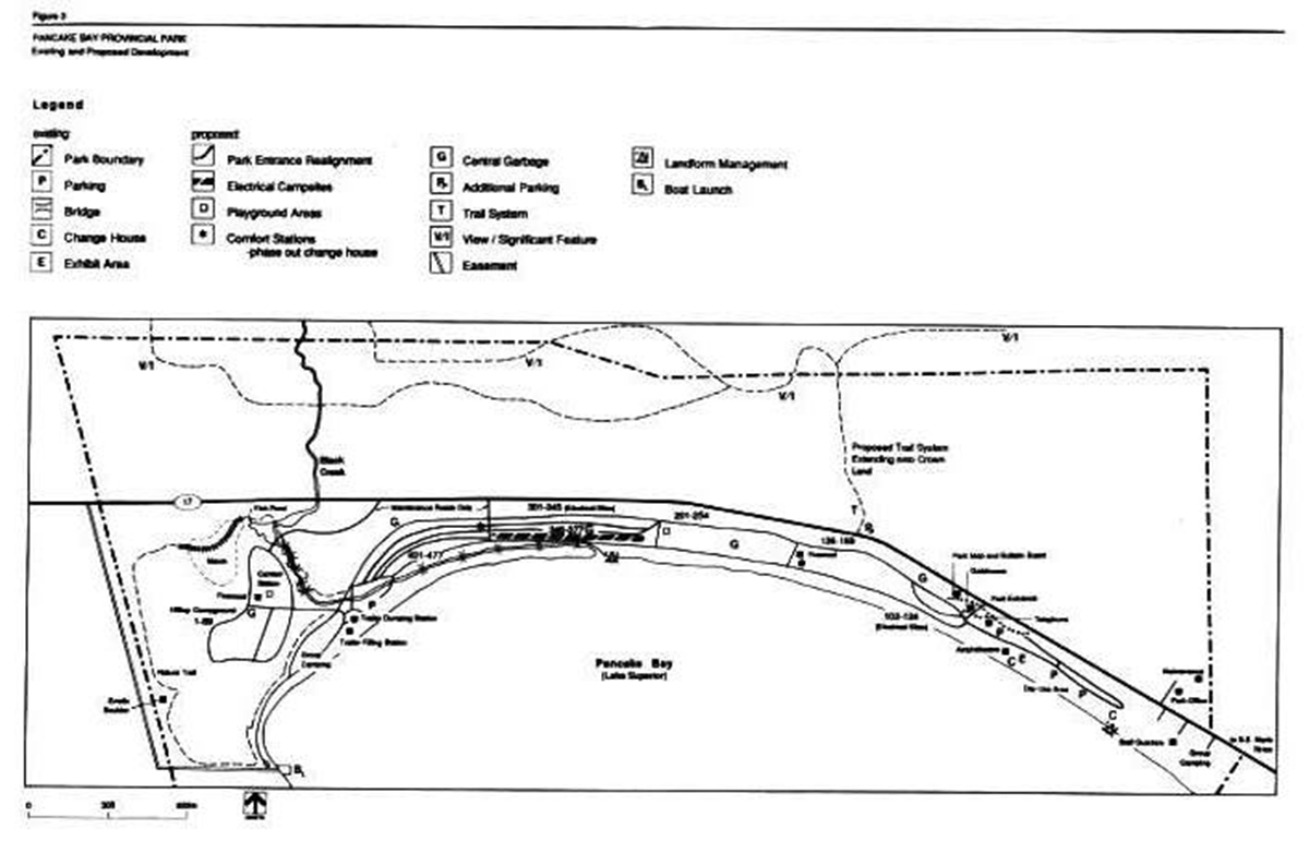
8.4 Maintenance
Maintenance costs could be reduced by removing unneeded structures and facilities. Wooden log bumpers will be removed in parking areas where vegetation cover or rocks could be used to control traffic and Parking. Unnecessary structures will be removed, such as the old gatehouse and the day use area change house.
8.5 Trails
Due to the relatively small size of Pancake Bay Provincial Park, additional trail development within the Park is not feasible. In keeping with the need to enhance visitors' awareness of the area, there are some excellent opportunities to develop self use trails to the north and northwest of the Park. These trails could be developed and promoted as part of the Park’s recreational experience.
A plan for trails north and northwest of the Park will be developed. The trail (or trails) should emanate from the Park and be promoted as part of the area’s attractions. Special attention should be given to establishing a safe crossing site across Highway 17.
8.6 Children’s play areas
There is presently one children’s play area situated near the Park entrance. Because of the linear nature of the Park, many campers are required to travel a considerable distance to enjoy this facility.
New children’s play areas will be developed near the hilltop campground comfort station and in the lower campground.
8.7 Amphitheatre
The amphitheatre, a wooden log structure, is deteriorating and must be replaced. The existing seating capacity at the theatre exceeds present use. Maintenance efforts can be reduced by replacing some existing wooden structures with metal and concrete, and by redesigning seating configurations.
The amphitheatre movie screen will be replaced with a metal frame structure requiring minimal maintenance.
Use at the amphitheatre will be monitored to determine seating requirements, and the most practical seating configuration and design will be developed.
8.8 Boat launching
Presently, there are no boat launching facilities in the immediate area of the Park. Boat launch facilities could be provided at the extreme west end of the Park. To avoid conflict with other Park users, it will be necessary to provide access directly from Highway 17 on lands outside the Park boundary. Development of this facility will be dependent on special funding Initiatives.
9. Plan implementation
This section summarizes the action statements in the plan. Implementation of the management plan will involve the preparation of an operating strategy and the development and management of approved facilities and services. This implementation is ongoing through work program planning and funding proposals. Over the next 20 years, there will be two phases to implement the plan.
9.1 Phase I
Several facility improvements and minor developments can be achieved through the process of work program planning and annual operations procedures.
Resource management
- resource management plans will be prepared for vegetation and shoreline landforms; and
- annual agreements will be established for fish stocking of the children’s fish pond
Visitor services
- prepare a visitor services plan guiding self use facilities
- continue the Park host and hostess program
- update the 1980 marketing plan
- replace the existing amphitheatre’s wooden superstructure with metal
- improve visitor orientation to Park and area attractions and services; and
- develop self-guided trail and display areas through a trail plan
Site and development management
- some derelict facilities will be phased out and sites will be rehabilitated: day use area changehouses, old gatehouse and roadside bumpers
- site development plans will be prepared for all new development in the Park:
- two new children’s play areas
- amphitheatre upgrading
- a redesigned Park entrance and gatehouse
- expansion of trails north of highway 17; and
- boat launch facility in Lake Superior
9.2 Phase II
Special funding is required to implement the development of some new facilities or to upgrade existing facilities. This funding goes beyond the park operating budget.
Approved site plans will be implemented as funds permit for:
- two new comfort stations, with the phasing out of vault privies that are no longer necessary
- increase the number of electrical sites
- trail development north of highway 17; and
- the abandoned MTC gravel pit on the north side of highway 17 and the triangular parcel of land south of highway 17 on the east side of Pancake Point will be acquired
10. Plan review
Once approved, the Pancake Bay Provincial Park Management Plan will be reviewed on an ongoing basis. After the first ten years of the Plan’s 20 year lifespan, a detailed review will be carried out.
11. Public consultation
This park management plan is a result of a continuing consultation process that has considered the needs, desires and opinions of a variety of interests. It marks an attempt to achieve balance economically, socially and environmentally, in our approach to the management of Pancake Bay Provincial Park for both now and the future. Public involvement in the management plan first began during the summer of 1986 with news releases requesting public participation in open house presentations scheduled at the Park and at the Sault Ste. Marie District Office. These presentations were maintained from mid-July to early September at the Park and the District Office. In July of 1986, copies of the preliminary management plan were mailed directly to interest groups, other government ministries and adjacent property owners. They were requested to submit, within 30 days, any comments regarding the management plan to the District Manager at Sault Ste. Marie.
During this review, the need for a boat launch facility on Lake Superior, within the Park, was identified. This proposal was evaluated by the public during January and February of 1988. In view of the comments received, and the absence of any significant objections, the plan was amended to allow for the development of a boat launch.
Copies of all comments received are available for viewing at the Sault Ste. Marie District Office.
In applying this park management plan, our Ministry is committed to continuing this consultation with other government agencies, businesses in the area of the Park, interest groups and the public in general. It is important that the channels of communication that have been created by this consultation process be kept open.
Select references
Macdonald, I.D., Pancake Bay Provincial Park, Life Science Inventory Check Sheet for OMNR, 1979.
Noble, T., Southern Boreal Forest (4E) Site Region Biophysical Inventory for OMNR, 1982.
Ontario Ministry of Natural Resources, Car Camping and Day Use Survey for Pancake Bay Provincial Park, OMNR, Toronto: 1979/1984.
Ontario Ministry of Natural Resources, Ontario Provincial Parks Planning and Management Policies, OMNR, Parks Planning Section, Toronto: 1978.
Ontario Ministry of Natural Resources, Sault Ste. Marie District Land Use Guidelines, OMNR, Toronto: 1983.