Petawawa Terrace Provincial Park Management Plan
This document provides policy direction for the protection, development and management of Petawawa Terrace Provincial Park and its resources.
52035 (0.1 k P.R., 20/10/2006) ISBN 1-4249-2207-0
Copies of this publication may be obtained on-line at the Ontario Parks' internet website or from the following locations:
Bonnechere Provincial Park
4024 Round Lake Road, RR#5
Killaloe, ON K0J 2A0
Tel:
Ontario Parks, Central Zone
451 Arrowhead Park Road
RR #3
Huntsville, Ontario P1H 2J4
Tel:
© 2006, Queen’s Printer for Ontario
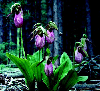
Cover photo: Pink Lady’s Slipper
Photo taken by: Grant Bickel
MNR 52035
(0.1 k P.R., 20/10/06)
ISBN 1-4249-2206-2 (Print) ISBN 1-4249-2207-0 (PDF)
Dear Sir/Madam:
I am pleased to approve the Petawawa Terrace Provincial Park Management Plan as the official policy for the management and development of this park. The plan reflects the Ministry of Natural Resources', Ontario Parks' intent to protect the natural and cultural features of Petawawa Terrace Provincial Park and maintain and develop opportunities for high quality outdoor recreation and heritage appreciation for the residents of Ontario and visitors to the Province.
This document outlines a prioritized implementation strategy for the plan’s elements and summarizes the public consultation that occurred as part of the planning process.
The public is given an opportunity to inspect this approved management plan for a period of forty-five (45) days after its formal release. This allows interested participants in the planning process a final opportunity to determine how their concerns have been considered.
The plan for Petawawa Terrace Provincial Park will be used to guide the management of the park over a twenty year time frame. It may be reviewed throughout its life span to address changing issues or conditions, and may be amended as the need arises.
I wish to extend my sincere thanks to all those who participated in the planning process.
Yours truly (signed by),
Adair Ireland-Smith
Managing Director
Ontario Parks
Date: October 10, 2006
Preface
Statement of Environmental Values and the Environmental Bill of Rights
In 1994, the Ministry of Natural Resources (MNR) finalized its Statement of Environmental Values (SEV) under the Environmental Bill of Rights (EBR). The SEV is a document that describes how the purposes of the EBR are to be considered whenever decisions are made in the Ministry that might significantly affect the environment. This includes decisions made as a result of the park management planning process.
The primary purpose of the EBR is to "protect, conserve and, where reasonable, restore the integrity of the environment." From the Ministry’s perspective, that broad statement of purpose translates into four objectives in its SEV:
- To ensure the long-term health of ecosystems by protecting and conserving our valuable soils, aquatic resources, forest and wildlife resources, as well as their biological foundations
- To ensure the continuing availability of natural resources for the long-term benefit of the people of Ontario
- To protect natural heritage and biological features of provincial significance; and
- To protect human life, the resource base and physical property from the threats of forest fires, floods and erosion
The Ministry’s SEV has been considered throughout the preparation of this park management plan. The management plan for Petawawa Terrace Provincial Park will further the objectives of managing Ontario’s resources on an environmentally sustainable basis.
1.0 Introduction
Petawawa Terrace Provincial Park is 200 hectares in size and is recommended as a natural environment class park. Natural environment class parks incorporate outstanding recreational landscapes with representative natural and historical features, and provide high quality recreational and educational experiences. Petawawa Terrace was regulated as a provincial park under Ontario Regulation 331/06 as Petawawa Terrace Provincial Nature Reserve. The park is being recommended for re-regulation to change the classification from nature reserve to natural environment.
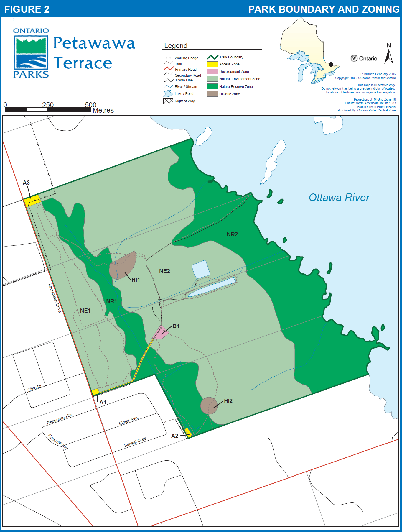
The park is approximately 160 kilometres north-west of Ottawa and 450 kilometres north-east of Toronto. It is within the Town of Petawawa in the County of Renfrew, encompassing parts of Lots 12-15, Lake Range C of the town (Figure 1). It also includes the small crown land islands east of Lots 13-15 (Figure 2). The larger islands northeast of the park are privately owned.
Special features on the property include a 30 m high sand terrace (earth science feature), natural springs, and several provincially and regionally significant life science features. The park also includes a portion of a locally significant floodplain encompassing the park from the base of the terrace to the Ottawa River.
Approximately 331 groups of herbaceous plants can be found within the park, including the provincially rare Lake Water-cress (Amoriacia lacustris), Field Sedge (Carex conoidea), Tubercled Orchids (Platanthera flava var. herbiola), and Prickly Coontail (Ceratophyllum echinatum). Ecosystem types within Petawawa Terrace range from pine dominated uplands to tolerant hardwoods and lowland hardwood swamps. Due to the variety of habitat types, many species of mammals, birds, reptiles, and amphibians also inhabit Petawawa Terrace. As well, the area is an important stop-over for some species of migrating birds.
Historically, part of Petawawa Terrace Provincial Park was designated as the Pembroke Crown Game Preserve in 1928. It was also the site of a provincial fish hatchery known as the Petawawa Fish Culture Station from 1929 to 1994. In 1983, the entire property was designated as an Area of Natural and Scientific Interest (ANSI) to protect its regionally significant earth science features.
During almost 70 years of operations, the Petawawa Fish Culture Station supplied lake trout and brook trout for stocking lakes and streams in Algonquin Provincial Park, and in Bancroft, Carleton Place, Napanee, Pembroke, and Tweed Ministry of Natural Resources (MNR) Districts.
The station’s staff was also responsible for implementing a number of wildlife management projects. In 1929 almost 600 elk were brought in from Manitoba to be raised for distribution in Ontario and Québec. Goose ponds were constructed in 1935. From 1951 to 1965, a goose sanctuary feeding area was established to attract migratory geese. From 1978 to 1984 a project to establish a resident flock of Canada Geese was initiated. Goslings and eggs were transferred to newly created "donut" nesting ponds. Although the nesting ponds are no longer managed, geese still nest there annually.
During its operation, the hatchery was open to the public and to school groups. It housed a small visitor area until the late 1980s. Over 4,000 visitors toured the facility in 1988. The hatchery also maintained 10 km of groomed ski trails on the property.
Although the fish hatchery activities were phased out and the facilities removed, the property continues to be used extensively by local residents of Petawawa and surrounding area for low impact recreational uses such as walking, hiking, and nature observation.
Petawawa Terrace Provincial Park overlaps traditional lands of the Algonquin First Nation. The Algonquin community is currently involved in land claim negotiations with Ontario and Canada. Their land claim area encompasses the Ontario portion of the Ottawa and Mattawa River watersheds. The regulation and management planning of Petawawa Terrace does not remove the park from consideration in the possible settlement of any land claim. The Ministry of Natural Resources will continue to identify and document sites of cultural significance in the park, which will be considered in management planning.
2.0 Classification
Through park classification, Ontario’s provincial parks are organized into different types of classes of parks, each of which has particular purposes and characteristics. There are six classes of provincial parks: wilderness, nature reserve, historical, natural environment, waterway and recreation.
As described in the Ontario Provincial Parks: Planning and Management Policies, Petawawa Terrace Provincial Park will be classed as natural environment. This class incorporates outstanding landscapes with representative natural features and historical resources to provide high quality recreational and educational experiences. The natural environment status will reflect the park’s provincially and regionally significant natural features, as well as its regional historical legacy and recreational values.
3.0 Goal
The goal of Petawawa Terrace Provincial Park is:
to protect natural features represented by the park, while continuing to provide recreational, interpretive and educational opportunities.
4.0 Objectives
The Ontario Provincial Parks System has four objectives: protection, heritage appreciation, recreation, and tourism. As a natural environment park, Petawawa Terrace contributes to all four objectives.
The park objectives provide specific direction for park management and are described as follows:
4.1 Protection
To protect significant elements of the park’s natural and cultural heritage.
This is the primary objective of the park. Protection will not be limited to provincially significant features. The protection objective will be accomplished through appropriate park zoning, land use practices and an ecosystem approach to park planning and management.
For ecosystem management purposes, Ontario is divided into 71 ecodistricts based on landform, physiography and climate. Petawawa Terrace lies at the extreme north-east boundary of Ecodistrict 5E-10 of the Georgian Bay Ecoregion, protecting natural environments representative of this ecodistrict. The specific significant natural and cultural features protected in the park’s nature reserve, historical and natural environment zones are listed in Section 6.0. These features include provincially significant earth and life science features, and cultural heritage features.
Figure 1: Petawawa Terrace Provincial Park regional setting map
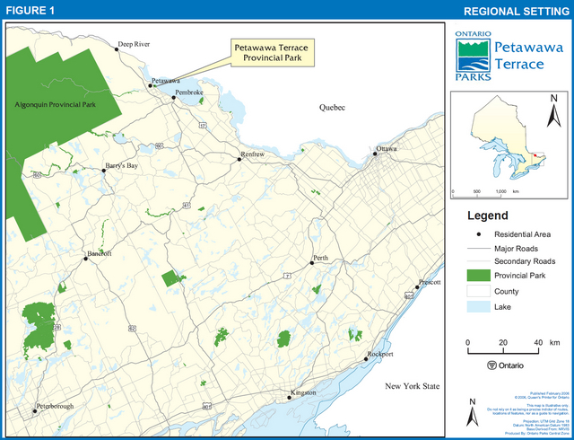
Enlarge Figure 1: Petawawa Terrace Provincial Park regional setting map
4.2 Heritage appreciation
To provide unstructured opportunities for exploration and appreciation of the park’s natural and cultural heritage.
Exploration and appreciation of the park’s natural and cultural heritage values will be encouraged, provided it’s compatible with protection objectives.
Self use facilities such as the existing trail system and interpretive panels will continue to provide opportunities to interpret natural and cultural features.
4.3 Recreation
To provide day use and related outdoor recreation opportunities appropriate to the park.
The park will emphasize non-motorized experiences compatible with and complementary to the protection of the park’s natural and cultural heritage values and its tourism objective. The park will continue to provide opportunities for low-intensity activities such as bicycling, walking, hiking, snowshoeing, cross-country skiing, nature appreciation, photography, and wildlife viewing. The terrace provides opportunities to experience scenic vistas of the Ottawa River. The diversity of habitats, especially on the lower terrace, makes the park a prime bird watching destination in all seasons.
Petawawa Terrace is connected to the extensive recreational trail network maintained by the Town of Petawawa making the park a popular spot for walking, cycling and hiking. Adjacent to the park, next to the main access point along Laurentian Avenue, is a newly constructed playground owned and maintained by the Town of Petawawa. This playground also attracts additional family visitation to the provincial park.
4.4 Tourism
To provide Ontario residents and out-of-province visitors with opportunities to discover and experience the park environment.
Tourism opportunities will be enhanced by achieving the park’s other objectives, and by working with the Town of Petawawa and community groups to enhance the tourism and recreation values of the park. The park will be promoted on the basis of its natural and cultural heritage values, and the enjoyment and appreciation these values offer. The park will be publicized in literature produced by Ontario Parks. In addition, the Town of Petawawa, an active stewardship partner, promotes the park on its website as well as other notices released to the public.
The park presents a variety of viewing opportunities and nature interpretation opportunities unique to the area. Petawawa Terrace currently offers a self- guided interpretive trail. The trail highlights various types of rare species. In the future, viewing platforms/towers will be constructed overlooking the Ottawa River. Current interpretive panels and additional panels will promote the park’s natural and cultural heritage values.
5.0 Boundary and land tenure
The park is located within the Town of Petawawa. It includes all of lots 12, 13 and 14 in the lake Range C, and part of lot 15 lake Range C. It also includes the small Crown islands east of Lots 13-15 (Figure 2).
The park is surrounded on three sides by private land; subdivisions to the immediate west and south, and larger private holdings to the north. The Ottawa River, abuts the eastern side of the park. The larger islands, situated near the north eastern edge of the park, are privately owned.
A municipally owned gated parkette and privately owned right-of-way are located off Sunset Crescent adjacent to the park boundary. They provide public access to the park from the south-west (A2 in Figure 2). A hydro transmission right-of-way, operated by Hydro One under an annual Land Use Permit (LUP), is located in the northern section of the park (Figure 2).
An annual LUP has been issued to the Petawawa Ski Club Inc. since 1994 to allow grooming of the cross country ski trails each winter (between December 1 and March 31).
6.0 Zoning
The areas within the park are zoned on the basis of their significance for protection and potential for development and recreation. As outlined in the Ontario Provincial Parks: Planning and Management Policies, natural environment class parks may include any of six types of zones: access, development, natural environment, historical, nature reserve and wilderness. Petawawa Terrace contains the first five of the six types. Each zone permits specific land uses and is managed according to specific strategies. The zone boundaries are shown in more detail on Figure 2.
The following sections briefly describe each zone. All resource and recreational uses and facility development will be subject to Ontario Park policies.
6.1 Nature reserve zones
Nature reserve zones protect the inherent values of provincially significant natural features, their contributions to the biological diversity of the park and the park system, and their potential for scientific research and natural heritage appreciation. These zones include significant earth and life science features requiring management distinct from that in adjacent zones. Activities include: walking, hiking, nature appreciation and non- destructive scientific research.
Zone NR1 (22.0 ha)
The Terrace and Springs
The terrace and springs NR1 zone includes the face of the terrace, the terrace springs and a water collection system (see Section 7.1.1) running parallel to the base of the terrace, as well as plant communities associated with the springs. The southern most portion of NR1 contains areas where sections of the water collection system have been removed. This area has been allowed to naturalize. Trails run along this disturbed area taking advantage of the fill deposited during the removal of the steel pilings. Pedestrians access these trails via the Laurentian Drive (A1) and Hydro right-of-way (A3) access zones, and through a municipally owned gated parkette near a privately owned right-of-way off Sunset Crescent (A2). All trails located in this zone have been limited to previously disturbed areas.
Two trails traverse the slope and provide access to the lower terrace – one from the Sunset Crescent subdivision and one from the upper terrace trails. Both trails are located on the beds of original homestead access lanes (see Section 7.3
Zone NR2 (48.1 ha)
Ottawa River Shoreline and Islands
This zone provides protection for the shoreline of the Ottawa River. This zone also includes the five small islands beyond the shoreline. The boundary to the waters edge will provide maximum protection for the sensitive vegetation communities along the shoreline of the mainland and islands (i.e. open Wool-grass and Rattlesnake Grass wetlands, Shining Willow thickets, and Silver Maple swamps). To minimize disturbance and damage to the sensitive shoreline vegetation there will be no trails established parallel to the shoreline. A single trail situated on a historical roadbed will provide the only access to the shoreline.
6.2 Natural environment zones
Natural environment zones include natural, cultural and aesthetic landscapes in which minimum development is required to support low-intensity recreational activities. Development in the park’s two natural environment zones is limited to trails, interpretive panels, and signs necessary for route identification, boardwalk or walking bridges, and viewing platforms/towers to support low-intensity recreational uses.
Vegetation management as described in Section 7.1.2 will be ongoing in the natural environment zones. Existing uses include bicycling, walking, hiking, cross-country skiing and snowshoeing will continue.
Zone NE1 (23.5 ha)
The Upper Terrace
The upper terrace NE1 consists of the entire upper terrace including a red pine plantation (approximately six ha) and the surrounding mixed coniferous forest. Vegetation management will be ongoing in this zone as described in Section 7.1.2.1. Two permanent sample plots, part of the MNR growth and yield program, are also located within this zone. Specific policy for these two areas is also outlined in Section 7.1.2.4.
This zone is the most intensively used area of the park due to its accessibility and number of trails. There is a total of 3.6 km of trails, providing loops of a variety of lengths. The Petawawa Ski Club track sets the outside loop of the terrace.
A trailhead kiosk (near A1 on Figure 2) provides a map of the park. Benches and interpretive panels are located along the trails.
Zone NE2 (102.0 ha)
The Lower Terrace
This zone includes the grounds of the former fish hatchery, the water diversion system leading from the terrace springs, as well as the surrounding former agricultural fields and current beaver ponds. A trail loops around the former fish hatchery ponds overlooking the historical goose ponds, beaver ponds, and a variety of vegetation communities. It provides excellent opportunities for wildlife and bird viewing as well as photography throughout the year.
6.3 Historical Zones
Historical zones encompass the cultural resources of a park. They include any significant historical resources requiring management distinct from that in adjacent zones. Historical zones will support minimum development required for visitor exploration and appreciation and scientific research. Development will be limited to trails, signs, brochures, and interpretive panels. Minor trail relocations may occur if necessary to protect the sites. Permitted activities include hiking, bicycling and cross country skiing.
Zone HI1 (1.5 ha)
The Patswald Homestead
This zone contains the ruins of the Patswald homestead built in the late 1800s and was occupied as part of a farm until the owners granted title to the province in 1931.
Zone HI2 (0.7 ha)
The Gutzman Homestead
This zone contains the farm most recently occupied by the Gutzman family. Because of safety concerns the buildings were demolished in the late 1980's. The boundary of the zone includes the extent of the occupation including the location of the building foundations.
6.4 Development Zones
Development zones usually provide the main access to the park and contain facilities and services for a wide range of day-use activities.
D1 (0.4 ha)
The development zone is located at the base of the terrace in the former location of the hatchery manager’s residence.
With the exception of parking for approximately 12 vehicles, no other development exists in the zone.
6.5 Access Zones
Three traditional access points to the park have been zoned as access.
A1 (<1 ha)
Laurentian Drive
This is the main access point to the park. It includes the entrance to the park from Laurentian Drive, a parking lot, as well as the existing gated road to the base of the Terrace and Zone D1. The parking lot provides parking for approximately 20 vehicles. It is used by park visitors as well as by local residents using an adjacent municipal park.
The road to the lower terrace is gated and remains closed, except for emergency use.
A2 (<1 ha)
Sunset Subdivision
This access zone is a pedestrian entrance to the park through a municipally owned gated parkette and a privately owned right-of-way located off Sunset Crescent (figure 2). This access point provides access to the park’s south west corner. There is no parking available at this entrance.
A3 (<1 ha)
Hydro Right-of-Way
This zone includes the entire northwest corner of the park within the hydro right-of-way. A gated entrance at this location provides vehicular access for emergency fire control, Hydro One, and Ontario Parks only. There is currently no parking at this entrance and the turnaround area will not be developed as a parking area. Only pedestrian traffic will be permitted through this entrance to the park. This access point provides an alternative entrance to the trails on the upper terrace.
7.0 Resource management policies
Petawawa Terrace Provincial Park will be managed in accordance with the policies for natural environment parks as set out in Ontario Provincial Parks: Planning and Management Polices, Ontario’s Living Legacy Land Use Strategy, and the specific policies of this plan.
Resource management initiatives supporting resource policies may be accomplished through partnerships and sponsorships.
In addition to the policies established in the remainder of Section 7, the following activities will be prohibited in the park:
- mineral exploration and mining
- aggregate extraction
- commercial forest operations
- commercial bait fishing
- commercial fur harvesting
- recreational hunting
7.1 Natural resources
The diversity of plant and animal life, the variety of habitats and the park’s attractive vistas all contribute to the park’s significance as a protected area.
7.1.1 Land and water management
The management of the park’s land base will be directed towards maintaining the natural landscape. Aggregate for park development and operations will be provided by commercial sources outside the park.
Numerous springs originate at the base of the terrace, resulting from percolating groundwater travelling through the terrace and surfacing where underlying sand meets the impermeable marine clays at the terrace’s base. The springs create several significant creeks flowing perpendicular to the terrace, eventually reaching the Ottawa River. A water collection system made of steel and wood pilings was established in the early 1930's to divert this water for use in the fish culture facilities. Some of the steel have since been removed. The remaining wood pilings are deteriorating.
To avoid further site disturbance, the remaining 400 m of steel pilings will be left and allowed to fill with silt and deteriorate. The area will naturalize slowly over time. This policy will be reconsidered if future study determines the steel pilings are causing negative impact to the environment.
Water levels on the Ottawa River may be variable. Ontario Power Generation holds a water power lease on the Ottawa River and, to some degree, controls flooding. Fluctuating water levels may cause parts of the shoreline to look very different throughout the year.
Figure 2: Petawawa Terrace Provincial Park boundary and zoning map
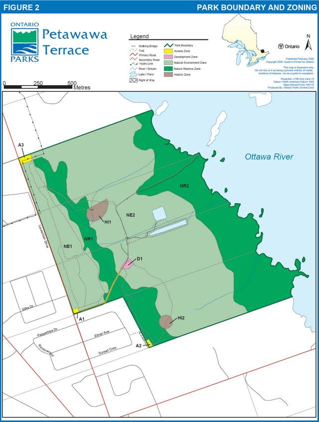
Enlarge Figure 2: Petawawa Terrace Provincial Park boundary and zoning map
7.1.2 Vegetation
Management will be directed toward increasing plant and habitat diversity. Where necessary, management will focus on the rehabilitation and restoration of disturbed sites.
The six hectare red pine plantation in NE1 will undergo active vegetation management as described in Section 7.1.2.1. Forest management in the remainder of the park will be limited to selective cutting of hazard trees located within one tree length of trails, or in any other areas where they pose a safety risk. Standing dead trees will be removed if considered a safety risk, but otherwise will be left in place as wildlife habitat. Windthrown trees will not be removed unless considered a threat to health or safety, or interfere with regular park operations. Any useable products from trees cut for management purposes will be retained for uses within the provincial park system. Other trees and brush cut will be left to deteriorate naturally or may be chipped for use on trails within the park. Vegetation may be pruned only:
- to enable resource or recreation management (e.g. trail maintenance)
- to enable facility development; or
- to ensure public safety
The MNR Growth and Yield program established two permanent sample plots in NE1 to monitor the growth rates of trees. Both are part of the long term monitoring program of forests in Ontario. They will be managed as described in Section 7.1.2.4.
Non-native plant species will not be intentionally introduced into the park. The control or eradication of non-native species and noxious weeds (e.g. poison ivy) may occur. Where control is undertaken, it will be directed as closely as possible to the specific plant species, so as to have minimal effects on the balance of the park.
Native species may be planted for the purposes of trail rehabilitation.
The non-forested vegetation communities of NE2 will undergo active vegetation management as described in Section 7.1.2.2.
Native insects and diseases affecting vegetation will be allowed to progress naturally except where significant park values are threatened. The control of non-native insect and disease species may occur where there is a threat to park values or to protect adjoining private lands. Where control is undertaken, it will be directed as narrowly as possible to the specific insect or disease so as to have minimal effects on the rest of the park’s environment. Biological and species specific controls will be used whenever possible.
7.1.2.1 Red pine plantation
The red pine plantation (six ha approx.) located within NE1 will undergo active vegetation management. The objective of these management activities will be to remove some of the red pine plantation and restore a natural diverse mixed hardwood forest. By increasing the diversity of the tree and shrub species, the habitat for wildlife will be improved.
The following vegetation management prescription will be implemented by or under the direct supervision of the park superintendent:
- A 55 m no cut buffer boundary around the permanent sample plot adjacent to the plantation (Section 7.1.2.4) will be established prior to any operations; the buffer boundary identification line will be temporary; there will be no trees marked for removal within this area
- Trees to be removed will be marked by certified tree markers
- The plantation will be marked for a selective thinning with the aim of reducing the basal area by approximately one third
- Trees will be selected for removal on the basis of species and individual tree health and overall condition
- In an effort to maximize species diversity, trees of incidental species (i.e. other than red pine or jack pine) will not be removed unless considered a safety risk
- In an effort to imitate natural disturbances such as wind storms and to encourage regeneration of tolerant and mid tolerant species, as many as four groupings of as many as eight trees may be removed where feasible
- The tops of the harvested trees will be left to decay unless considered a threat to health or safety, or interfere with regular park operations; the poles will be removed to be used within the provincial park system
- Borax may be placed on stumps to help control the spread of disease to other trees in the plantation.
- Wherever possible, existing natural regeneration will be protected during thinning operations
- Regeneration will be assessed annually following the thinning operation.
- If, after five years, regeneration assessments show areas with insufficient natural regeneration, planting or seeding of native species may be considered to accelerate natural processes
- The plantation will be assessed by qualified forestry personnel 10 years after the thinning to determine the timing for subsequent thinning. A new vegetation stewardship prescription may be written at that time to reflect the present forest conditions
7.1.2.2 Non-forested vegetation communities (NE2)
The non-forested vegetation may be actively managed when and where necessary to maintain diverse plant communities and habitats. Traditional field or meadow areas will be maintained to provide continued good bird habitat and viewing opportunities. This could involve periodic mowing and other activities. Also, to prevent flooding of further areas, and to maintain access to the zone and to protect trails, the control of beaver activity may be considered.
7.1.2.3 Hydro right-of-way
A land use permit has been issued by the Ministry of Natural Resources to cover all Ontario Hydro transmissions and distribution lines on Crown land. This land use permit will apply to the hydro right-of–way in Petawawa Terrace Provincial Park
Vegetation in the right-of-way will be controlled through mechanical means (‘brushcutting' where possible, manually with ‘brushsaws' where inaccessible). The use of herbicides will not be permitted for vegetation control within the right-of-way, except for the application of Garlon 4 (or a similar herbicide) to tree stumps to prevent sprouting. The park superintendent must be contacted and give approval before any projects are undertaken within the park boundaries.
7.1.2.4 Growth and yield permanent sample plots
There are two growth and yield plots located in NE1. The plot located in the centre of the natural jack pine stand (CE7016) sustained considerable damage during a wind storm in 1998. A majority of the trees were removed for safety reasons. The remaining trees in this plot are not being monitored at this time. The other plot (CE7029) is still being monitored as an unmanaged stand. As directed in permanent sample plot guidelines, this plot will be protected from possible impacts from managing adjacent stands by establishing a 55 m area of concern around the perimeter of the plot. No trees, with the exception of those posing a safety concern adjacent to trails, will be cut in this area.
7.1.3 Wildlife
The management of wildlife will be directed toward promoting healthy and diverse populations.
Recreational hunting will not be permitted in any area of the park. Traditional offshore hunting (i.e. beyond the water’s edge park boundary) may continue. Commercial fur harvesting is not permitted.
Wildlife management may be carried out occasionally in order to protect the health and safety of park visitors, or to protect park facilities. The removal of nuisance animals will be undertaken under the supervision of the park superintendent. If the removal of an animal is required, the trapper who last held the trapping licence for the area will be the first contact. If the trapper is unavailable, the superintendent will arrange for a local licensed trapper to remove the animal.
7.1.4 Forest fire management
Because of the park’s location within an urban area, all fires will be controlled. "Light on the Land" suppression techniques which have the least residual impact on the park’s natural environment will be utilized whenever possible.
Under a written agreement with the Ministry of Natural Resources, the Town of Petawawa Fire Department provides first response forest fire protection for the park. If required, the Ontario Ministry of Natural Resources will assist in any fire suppression tactics.
The fire department accesses the north western corner of the park along Laurentian Drive via a gated road. With the exception of emergency vehicle access, Ontario Parks access, and Hydro One for right-of-way maintenance, this access will remain locked at all times. The access road leading to the lower part of the park will be kept free and clear of debris for fire suppression purposes.
7.2 Cultural resources
Cultural resources will be managed to ensure their protection, and to provide opportunities for heritage appreciation and research where these activities do not impair the resource. This will be achieved through zoning and by controlling recreational activities and research that may occur in these areas. Archaeological and historical artefacts may only be removed and heritage landscapes altered as part of an approved cultural heritage research or management project.
Two historical zones, both old homesteads, have been identified in the park. A stage 1 & 2 archaeological assessment has been conducted at the site of the Patswald homestead in HI1. (Swayze, 2004). Further archaeological assessment of areas in the park, particularly the Gutzman farm and the shoreline areas, will be completed as resources permit.
7.3 Recreational resources
Walking, hiking, cross-country skiing/snowshoeing, and bicycling will be confined to designated trails shown in Figure 2. Development is minimal, and may include signs and trails. The trails on the upper terrace are wheelchair accessible. Trails will be clearly marked to reduce deviation from the main route. Trails will be monitored closely for signs of site degradation. Stairs, minor trail additions and relocations may occur to protect sensitive features or for health and safety reasons. Access to these trails and cut-offs (not indicated in Figure 2) will be blocked, and the trails will be allowed to naturalize. Ontario Parks will post trail directional and safety signs as required. Motorized vehicles (such as snowmobiles, ATVs, and motorbikes) are not permitted on the trails or within the park unless needed for emergency use or for trail maintenance work. Bicycling will be permitted to continue. If the use of bicycles is deemed unsafe to other park users or harmful to park values, use of bicycles within the park or within certain sections of the park may be prohibited.
Where deemed necessary, surfaces such as crushed rock screenings or wood chips may be added to park trails in all zones to reduce compaction of soil, damage to exposed roots, and to lessen the possibility of user injury. If necessary, stairs will be constructed to assist with erosion control along the trails traversing the terrace. Boardwalks and bridges may be constructed along trails on the lower terrace to assist with erosion control and to allow passage through wet areas with the least disturbance to the site. Viewing platforms/towers at key locations along the trails at the edge of the terrace (NE1) and within NE2 will be erected. Trails are discussed further in Section 8.4.
8.0 Operations policies
Operational policies deal with topics such as natural heritage education, recreation management, and the provision of recreation services, business planning and research. Petawawa Terrace Provincial Park is a non-operating park. Ontario Parks may consider partnership and or sponsorship arrangements to allow some level of operation in the park.
A park operating plan and business plan will be prepared within five years. This operating plan will provide park staff and potential partners with the necessary information required to operate the park on a day-to-day basis. In addition to addressing operational policies, the operating plan will address areas such as budget, staffing, maintenance, enforcement and emergency services. The provisions of the operating plan will be consistent with the Ontario Provincial Parks Minimum Operating Standards (1992). The operating plan may be reviewed annually and revised as required.
8.1 Natural heritage education
Natural heritage education in provincial parks is intended to develop visitor awareness and appreciation of Ontario’s natural and cultural heritage, and fosters a commitment to protecting that heritage for all generations. Natural heritage education opportunities are meant to be educational and recreational, formal and informal, and accessible to all.
The level of service that each park provides depends on its significance and visitation. Services for visitors to Petawawa Terrace will be oriented toward self-guided use.
8.1.1 Park information
A trailhead, or information kiosk, located at A1 (see Figure 2) will provide visitors with information regarding the park, its resources, operating times, prohibited activities, the environment and facilities. The trailhead will include a park map, enabling visitors to familiarize and explore the park. A "respect the environment" ethic will be promoted in order to minimize human impact on the park environment. The importance of respecting other users will also be emphasized.
8.1.2 Interpretation
Interpretive facilities will provide park visitors with a greater appreciation for and an understanding of the natural and cultural features of Petawawa Terrace Provincial Park. Natural heritage education facilities and services will focus on self guided interpretive trails and viewing platforms/towers in conjunction with interpretive panels and possibly leaflets. Currently, there are only self-guided trails in the park. Future development will include the viewing platforms/towers, more interpretive panels and possibly educational brochures.
8.2 Research
Research by qualified individuals contributing to the knowledge of natural and cultural history, and to environmental and recreational management objectives of the park, will be encouraged.
All research projects will require the approval of Ontario Parks, and must be consistent with provincial parks research policies and all applicable legislation. Research activities will also conform to the Research and Information Strategy Ontario Parks, Central Zone 2004-2009 (2004), as it relates to current science, research, and information needs. Sites altered by research activities will be rehabilitated as closely as possible to their previous conditions.
8.3 Partnerships
Ontario Parks will work closely with the Town of Petawawa as a stewardship partner. Other formal partnership agreements may be established between Ontario Parks and other organizations from outside the parks' system. Partners may represent the local community, and local and provincial interests. Partners will work with Ontario Parks to implement the approved park management plan and operating plan according to provincial park policies and regulations (Section 10.1).
8.4 Recreation management
Trails in the park will be for non-motorized use (e.g. walking, hiking, cross-country skiing, bicycling, and snowshoeing). Staff of Ontario Parks, the Town of Petawawa and other partners will be permitted to use mechanized vehicles for operation and maintenance purposes. Recreational activities will be confined to designated trails (Figure 2).
The Petawawa Ski Club holds an annual LUP permitting grooming of the cross-country trails each winter between December 1 and March 31. This LUP will be reviewed on an annual basis. Other partnerships for trail maintenance may be explored.
Cycling along existing trails in nature reserve zones and historical zones may continue as a non-conforming use, however trails will be monitored for damage and if damage is occurring from cycle use, the trail may be repaired to accommodate cyclists or closed to cyclists.
The following recreational activities will not be permitted in the park:
- camping
- open fires
- rock climbing
- horseback riding
- recreational hunting
- physical geo-caching and adventure racing type activities.
9.0 Development policies
Development policies identify priorities for new development as well as redevelopment of existing facilities. Development is implemented through business and work program planning, based on priorities, and subject to the availability of funds. Ontario Parks may install a self-serve fee station if additional facilities are constructed within the park.
9.1 Trails
Park trails are for pedestrian and bicycle use only. New trail segments to access viewing platforms/towers will be built on the upper terrace and to standards. Trails will be marked with directional and safety signage as required. The trailhead will display a map of the trail system highlighting the current location of the user. Minimum impact ethics for park users as well as park regulations may be prominently displayed. Trails that are deemed unsuitable for pedestrians will be closed. Existing trails will be maintained.
9.2 Interpretive facilities
Interpretive facilities will be modest, consisting of interpretive panels at the trailhead and at key locations along the trails. To provide opportunities to view scenic vistas, a viewing platform/tower may be developed in NE1 at the edge of the terrace, overlooking the lower terrace, the Ottawa River and the Gatineau Hills.
To facilitate wildlife viewing, up to two additional viewing platforms/towers may be constructed along the trails in NE2 overlooking field and wetland habitats.
9.3 Park maintenance and operation facilities
Other than park entrance facilities, development of park operations and maintenance facilities will not occur in the park. Entrance facilities that are permitted include:
- buildings or structures that deliver the interpretive and outdoor education messages
- a bus turnaround in the parking lot
- boundary barriers in the parking lot
- a picnic shelter
- garbage containers; and
- washroom facilities
In all future development, Ontario Parks will not allow unnecessary undirected light pollution. This commitment recognizes the natural values provided by a pristine night sky.
All projects are subject to Class Environmental Assessment for Provincial Parks and Conservation Reserves (Class EA) requirements and other approvals.
10.0 Plan implementation
Managing the park will is subject to the requirements under Class Environmental Assessment for Provincial Parks and Conservation Reserves
Implementation Priorities
Priority will be given to completing the following initiatives. All projects identified in this plan are subject to the requirements under Class Environmental Assessment for Provincial Parks and Conservation Reserves.
Implementation priorities include:
- development of a park operating plan and business plan
- vegetation management in red pine plantation (Section 7.1.2.1)
- completion of archaeological site assessment of park
- statement of fire intent
- vegetation management in non-forested areas of NE2
- continued expansion and enhancement of the self-guided interpretive trails including installing new interpretive panels
- development of viewing platforms/towers in NE1 and NE2
- installation of boundary barriers at parking area in D1
- development of washroom facilities and picnic shelter if visitation warrants and is supported through the business plan; and
- self-serve fee station if supported through the business plan
Implementation or site plans will precede major development or significant resource management initiatives, and will include an appropriate level of public consultation.
10.1 Partnerships
In the implementation of the approved park plan, Ontario Parks will work closely with the Town of Petawawa as a stewardship partner. Ontario Parks will also explore opportunities for partnerships involving volunteers, school boards, a "Friends of the Terrace" organization, Canadian Forces Base Petawawa, non-government organizations and others. Such partnerships will be essential to the achievement of the park’s protection, heritage appreciation, recreation and tourism objectives.
Future partnership areas that Ontario Parks may explore include:
- fostering sponsorships of interpretive displays and facilities, educational programs, and special events
- increasing community involvement in natural heritage education
- increasing involvement in natural heritage inventory, research and stewardship; and
- operating the cross country ski trails
11.0 Plan review and amendment
The Petawawa Terrace Provincial Park Management Plan is intended to provide a 20 year horizon for management activities and to set the context for routine park operations. The plan will be assessed every ten years to determine if a review is necessary. If deemed necessary, a review will be carried out; otherwise the plan will be left as is.
The plan may be reviewed or amended if required at any time during its 20 year term. Management plan reviews involve proposed changes to the plan’s management or development polices, consistent with the classification, zoning, goal and objectives. Amendments can either be major or minor and may be processed to correct or update existing, or include new information.
12.0 Public consultation
Public involvement in the development of the management plan for Petawawa Terrace began with a public information session held at the Petawawa Civic Centre in June 2002. This meeting introduced the public to the planning process. The Managing Director of Ontario Parks approved the Terms of Reference for this planning project in August 2002. A notice was placed on the Environmental Bill of Rights Environmental Registry announcing a 45-day opportunity for public inspection of the Terms of Reference. An invitation to participate in the process was mailed to approximately 350 individuals and organizations that had either expressed interest in being on the mailing list or were believed to have an interest. In addition, the invitation was sent to the Ontario Parks mandatory mailing list, including local First Nations. An advertisement was also placed in local newspapers. Another information session was held in October 2002 to discuss the Terms of Reference and the remaining planning process. Four comments were received from the public, primarily supporting the planning process.
The Petawawa Terrace Background Information, Issues and Plan Alternatives document was released in June 2004. Approximately 350 copies of the document and an accompanying questionnaire were distributed in June and July 2004 by mail to mandatory contacts, local First Nations, those that responded to the invitation to participate, and to the local media. The notice was updated on the Environmental Registry announcing the 45-day review period. The comment period ended August 12, 2004.
The preliminary management plan was released on May 15, 2006 for a 60-day review and comment opportunity. The opportunity to comment was announced through newspaper notices in the Pembroke Observer and the Petawawa Post and a posting on the Environmental Bill of Rights' Environmental Registry. The preliminary plan gave interested individuals and parties the opportunity to review and comment on the management policies and activities being put forward for Petawawa Terrace Provincial Park. A notice was sent to those on the park planning mailing list (387 individuals and organizations) detailing how a copy of the preliminary plan could be obtained, information regarding the amendment to the Crown Land Use Policy Atlas, and the location and time of the public information session. The information session was held on May 31, 2006 at the Petawawa Municipal Hall and was attended by 15 people. During this stage, eight submissions were received.
The preparation of the recommended park management plan considered all comments received during the previous phases of the planning process. In summary, the major changes made between the preceding document and the final park management plan includes the following:
- A statement was inserted allowing staff from Ontario Parks and the Town of Petawawa to use mechanized vehicles for operation and maintenance and emergency purposes
- All instances of "viewing platform" were changed to "viewing platform/tower" so there is no misinterpretation of the meaning of platform
- The nature reserve zoning on the upper terrace (NR1) was reduced slightly at the north-west corner of the park to exclude the hydro transmission lines
- The poles of harvested trees may be used for park purposes; the tops will be left to decay unless considered a threat to health or safety, or interfere with regular park operations
- Bicycling will be permitted within the park on designated trails and will continue at the discretion of the park superintendent
- The park was regulated during the planning process; the plan was updated to reflect the regulation
The approved park management plan was published and released in November 2006 in conjunction with a paid advertisement in the Pembroke Observer and the Petawawa Post. Mandatory contacts and all those persons or groups who directly contributed to the planning process (85 individuals and organizations) were sent a letter regarding the release of the final document. A policy decision notice was posted on the Environmental Bill of Rights' Environmental Registry. The public had a 45-day opportunity to review the plan contents. This allowed interested participants a final opportunity to determine if their concerns had been adequately considered and addressed, and to initiate an appeal of the plan contents where appropriate.
The approved Petawawa Terrace Park Management Plan will be assessed every 10 years to determine the need for review. The plan may be reviewed or amended sooner to address changing issues or conditions. A review may involve a reassessment of all or part of the plan, including classification, zoning, goal, objectives and all resource management, operations and development policies, while an amendment may be considered to address specific issues or needs.
All comments regarding the Petawawa Terrace Preliminary Park Management Plan (2006) were considered during the development of the approved park management plan.
13.0 Key references
Brunton, D.F. 1982. A Life Science Inventory of the Petawawa Fish Hatchery Property, Petawawa, Ontario. Ministry of Natural Resources, Central Region Office Huntsville.
Brunton, D.F. 1991. Life Science Areas of Natural and Scientific Interest in Site District 5-10. Life Science Checklist. Ontario Ministry of Natural Resources Central Region Office, Huntsville.
Environment Canada. 2005. The Green Lane.
Korol, J.B. 2001. A Reconnaissance Life Science Inventory of the Proposed Petawawa Terrace Provincial Nature Reserve. Central Zone Office, Ontario Parks, Huntsville.
Korol, J. B. 2004. Research and Information Strategy, Ontario Parks, Central Zone (2004-2009). A report prepared for the Central Zone Office, Ontario Parks, Huntsville.
Mansell, W.D. and T.G. Harrison. 2001. A Life Science Inventory of Petawawa Terrace Provincial Nature Reserve. Town of Petawawa Parks and Recreation Department.
Ontario Parks. 1992. Ontario Provincial Parks: Planning & Management Policies. Queen’s Printer for Ontario.
Ontario Parks. 1994. Ontario Provincial Park Management Planning Manual. Queen’s Printer for Ontario.
Ontario Parks. 2005. Species at Risk in Ontario List.
Ontario Ministry of Natural Resources. 1996. Petawawa Terrace ANSI Management Plan-DRAFT. OMNR, Pembroke District
Ontario Ministry of Natural Resources. 1999. Ontario’s Living Legacy Land Use Strategy. Queen’s Printer for Ontario.
Ontario Ministry of Natural Resources. 2004. Petawawa Terrace Background Information, Issues and Plan Alternatives. Ontario Parks Central Zone Office.
Ontario Ministry of Natural Resources. 2005. A Class Environmental Assessment for the Provincial Parks and Conservation Reserves. Queen’s Printer for Ontario.
Pileggi, M.C. and P. A. Gray. 1991. Crown Game Preserves in Ontario. Prepared for the Ontario Wildlife Working Group, OMNR.
Spek, C. and P.J. Barnett. 1980. Petawawa Fish Hatchery (proposal) Earth Science Inventory Checksheet. Ministry of Natural Resources, Central Region Office, Huntsville
Swayze, K. 2004. A Stage 1 & 2 Archaeological Assessment of B1Gh-1 Petawawa Terrace. Part lot 14 Concession Lake Range Petawawa Twp (Geo) Renfrew County. Central Zone Office, Ontario Parks, Huntsville.