Peter’s Woods Provincial Park Management Plan
This document provides policy direction for the protection, development and management of Peter’s Woods Provincial Park and its resources.
© 2009, Queen’s Printer for Ontario
Ontario Parks is a program of the Ontario Ministry of Natural Resources
Additional copies of this document may be obtained from:
www.ontarioparks.com/planning (Link no longer active)
Print copies of this publication are available from the Ministry of Natural Resources for $10.00 plus applicable taxes per copy from the following location:
Darlington Provincial Park
1600 Darlington Park Road, RR 2
Bowmanville, ON L1C 3K3
Tel:
MNR 52145
ISBN 978-1-4249-5958-7 (Print)
ISBN 978-1-4249-5959-4 (PDF)
Dear Sir or Madam:
I am pleased to approve the Peter’s Woods Provincial Park Management Plan as Ontario Parks' policy for the management and development of this park. The plan reflects the Ministry of Natural Resources' intent to protect the natural features of Peter’s Woods Provincial Park.
This plan was developed with the assistance of the Nature Conservancy of Canada (NCC), which is the landowner of park additions recommended by this plan (Burnley-Carmel, Parts 2 and 3 of the park). NCC will have an active role in implementation of the policies in this plan, particularly policies for vegetation management and monitoring.
This document presents an implementation strategy for the plan’s elements and a summary of the consultation that occurred as part of the planning process.
The plan for Peter’s Woods Provincial Park will be used to guide the management of the park over a twenty year time frame. It may be amended as the need arises and will be examined in 10 years to determine the need for review to address changing issues or conditions.
I would like to express my appreciation to all those who participated in the planning process. Your valuable ideas have assisted in the completion of this plan.
Sincerely,
Signed by:
The Honourable Donna Cansfield
Ontario Minister of Natural Resources
Date: May 27, 2009
1. Context
1.1 Statement of Environmental Values and the Environmental Bill of Rights
The Ministry of Natural Resources' Statement of Environmental Values (SEV) under the Environmental Bill of Rights (EBR) describes how the purposes of the EBR are to be considered whenever decisions are made in the Ministry that might significantly affect the environment. This includes decisions made as a result of preparing management direction for a protected area.
The Ministry’s SEV has been considered throughout the planning process. The management direction for Peter’s Woods Provincial Park will further the objectives of managing Ontario’s resources on an environmentally sustainable basis.
1.2 Planning context
This management plan has been prepared consistent with direction contained in Our Sustainable Future, Ministry of Natural Resources Strategic Directions (2005). This document has also been prepared consistent with direction contained in Protecting What Sustains Us: Ontario’s Biodiversity Strategy (2005). The Ministry’s vision is "sustainable development" and the Ministry’s mission is "ecological sustainability". The Ontario Parks program contributes mainly to the goal of: "Healthy Natural Environment for Ontarians", but contributes to other strategic elements as well. The mandate of the Ministry for Ontario Parks is to deliver Ontario’s parks and protected areas program, which includes: the protection and management of provincially significant natural, cultural, and recreational environments, provincial parks operations, provision of tourism opportunities, natural heritage education, planning and management of parks and protected areas, policy and program leadership on conservation reserves, monitoring, auditing, and public reporting on Ontario’s protected areas
Peter’s Woods Provincial Park is situated on the Oak Ridges Moraine, one of Ontario’s most significant landforms, that stretches 160 kilometres from the Trent River in the east to the Niagara Escarpment in the west. The park’s protection is consistent with direction in the Oak Ridges Moraine Conservation Plan, as further described in Sections 2.0 and 6.2 of this plan.
This management plan provides policy direction for the management of Peter’s Woods Provincial Park. It is based on the terms of reference; background information, and issues and optional approaches summary; preliminary park management plan; and input received from consultation.
1.3 Aboriginal context
Peter’s Woods Provincial Park is located within the area covered by the Williams Treaty signed in 1923. No long term Aboriginal occupation of the site is known to have occurred. The park is south of two Mississauga communities, the Alderville First Nation located south of Rice Lake and Hiawatha First Nation located on the north shore of Rice Lake.
2. Introduction
Peter’s Woods Provincial Park is located 20 kilometres (km) northeast of Cobourg within the geographic township of Haldimand, now the Township of Alnwick/Haldimand, in the County of Northumberland. The park is located within the northern edge of the rolling landscape of the Rice Lake Plains area of the Oak Ridges Moraine in Ecodistrict 6E-7 (Uxbridge)
The park lies within the Ministry of Natural Resources (MNR) Peterborough administrative district and is administered by the park superintendent at Darlington Provincial Park near Oshawa, reporting to the Ontario Parks, Southeast Zone office at Kingston.
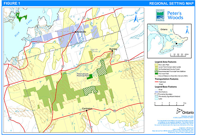
Peter’s Woods is accessible from Highway 45 by following County Road 29 to Burnley, or from Highway 401 following the Centreton exit and County Road 23. A series of local rural roads connect these two county roads and the park (Figure 1).
The original 33 hectare (ha) Peter’s Woods Provincial Park was regulated under the Provincial Parks Act in 1976. The park is non-operating and development is limited to a small parking area and one hiking trail. Two blocks of land acquired in 2002, formerly known as the Burnley-Carmel property, are recommended for addition to the park through this plan, and will substantially increase the park’s size (Figures 1-4, Section 6.0). For the purposes of this plan, the park will be considered to include all three areas or parts. Provincial park designation of park additions is subject to a boundary amendment.
The original park (hereafter referred to as Part 1) supports one of the most mature deciduous woodlands in southern Ontario, and has been defined as "older-growth". It was acquired through cooperation between the Willow Beach Field Naturalists and the Ministry of Natural Resources. The Willow Beach Field Naturalists provided financial assistance for the acquisition, made important contributions to a 1977 master plan and 1990 management plan, and continue to provide valuable assistance in the management of the park. This plan updates and replaces the previous management plan.
Peter’s Woods is named in honour and commemoration of Mr. A. B. "Peter" Schultz, a naturalist, conservationist and leading member of the Willow Beach Field Naturalists.
In 2002, the Nature Conservancy of Canada (NCC) purchased 317 ha of land from the Oak Valley Tree Farm. This purchase was made under the Legacy program partnership with Ontario Parks to secure significant natural areas in the province. The property, formerly known as Burnley-Carmel, consists of two blocks, a north block and a south block (hereafter referred to as Part 2 and Part 3 respectively), which are separate from Part 1 but are within one kilometre of it. This site contains high quality and degraded areas of tallgrass prairie and oak savannah habitat, and has the potential to support some of the best tallgrass prairie and oak savannahs in all of Ontario. This property was purchased with the intent of adding it to the existing park, and it is recommended for addition to the park through this plan (Section 6.0).
Parts 2 and 3 of the park abut the Northumberland County Forest, a 2,164 ha forested area managed by the County of Northumberland, with a variety of multi-use trails. The County Forest is situated mainly within the Township of Alnwick/Haldimand, with a small section in Hamilton Township. Previously managed by the MNR, the County Forest was originally developed as an Agreement Forest to address soil erosion and groundwater protection. The forest contains numerous high quality areas of tallgrass prairie, savannah and woodland as identified in a recent Tallgrass Communities Assessment prepared by the NCC. The County of Northumberland is working in partnership with the Rice Lake Plains Joint Initiative (Section 9.4) to preserve and restore these and other ecologically significant habitats in the forest.
There are no other provincial parks within the Rice Lake Plains area of the Oak Ridges Moraine. Other protected areas or areas of significant habitat within the Rice Lake Plains include the Alderville First Nation Reserve, Nature Conservancy of Canada properties, Northumberland County Forest, Burnley Creek Natural Habitat Area and Alderville Woods Natural Habitat Area; the latter two areas being administered by Lower Trent Region Conservation Authority. The significance and protection needs of the Rice Lake Plains have been recognized through the formation of the Rice Lake Plains Joint Initiative, consisting of six founding partners including the NCC and Ontario Parks (Section 9.4.1).
Preparation of this plan involved a review of background information, including information gathered from site visits and inventories. The field studies provided a detailed inventory of ecological features, and an assessment of local landscape context and human land uses. This work included botanical inventories, ecological land classification and wildlife surveys. Information compiled from background sources and field studies were analyzed to determine the significance and sensitivity of the ecological features and functions of the property.
The Peter’s Woods Provincial Park Management Plan was developed in accordance with the Ontario Provincial Parks: Planning and Management Policies (1992) and the Lindsay District Land Use Guidelines for the Ministry of Natural Resources (1983). In accordance with this plan, MNR has amended affected area-specific land use policies and mapping found in the Crown Land Use Policy Atlas.
The approved management plan will guide the management, operation and development, of Peter’s Woods over the next 20 years. The plan will be examined in 10 years or amended as the need arises. Section 11 describes the process for review and amendment of the plan.
Figure 1: Regional Setting Map
Enlarge Figure 1: Regional Setting Map
3. Classification
Through park classification, Ontario’s provincial parks are organized into broad categories, each of which has particular purposes and characteristics. Park classification defines an individual park’s role in providing opportunities for environmental protection, recreation, heritage appreciation and / or tourism.
Peter’s Woods is a nature reserve class park. The policies for nature reserve class parks provide the greatest level of protection of all classes of parks. In recognition of the park’s significant life science features, the nature reserve classification will continue. The nature reserve park classification will be extended to include Parts 2 and 3 (the Burnley-Carmel property), resulting in a single, larger nature reserve class park (Section 6).
Nature reserve park classification is most appropriate for Parts 2 and 3, given the significant habitats and rare community types within the properties, the opportunity to restore oak savannah and tallgrass prairie communities, and the opportunity to protect representative natural features of this area of the Oak Ridges Moraine. They are an important linkage connecting natural habitats in the area (e.g. provincially significant wetlands, ANSI).
From this point forward, the term "Peter’s Woods" will refer to all areas within the regulated protected area and recommended boundary.
4. Goal
The goal of Peter’s Woods Provincial Park is to protect and perpetuate significant and representative natural heritage features, including older-growth forest, tallgrass prairie and oak savannah.
Peter’s Woods Provincial Park is governed by Ontario’s Provincial Parks and Conservation Reserves Act, the Ontario Provincial Parks Policy and Ontario Provincial Parks: Planning and Management Policies (1992).
In order to meet the park’s goal, the policies in this document allow for reduction of pressures on the park, which ultimately supports ecological integrity. Pressures include a lack of natural disturbance regimes (e.g. fire), invasive species, habitat fragmentation and recreational use.
5. Objectives
Ontario’s provincial parks system has four objectives for establishing and managing provincial parks, as stated in Ontario’s Provincial Parks and Conservation Reserves Act:
- to permanently protect representative ecosystems, biodiversity and provincially significant elements of Ontario’s natural and cultural heritage and to manage these areas to ensure that ecological integrity is maintained
- to provide opportunities for ecologically sustainable outdoor recreation opportunities and encourage associated economic benefits
- to provide opportunities for residents of Ontario and visitors to increase their knowledge and appreciation of Ontario’s natural and cultural heritage; and
- to facilitate scientific research and to provide points of reference to support monitoring of ecological change on the broader landscape
The objectives of nature reserve class parks are to protect representative ecosystems and provincially significant elements of Ontario’s natural heritage, including distinctive natural habitats and landforms, for their intrinsic value, to support scientific research and to maintain biodiversity. Peter’s Woods' contribution to the nature reserve class park objectives are as follows.
5.1 Protection
The park’s protection objective is:
- To protect and restore significant elements of the park’s natural heritage
This is the primary objective of the park. Protection of globally rare tallgrass communities and species, older-growth forest, and wetlands will be paramount. Protection will not be limited to provincially significant features. Park management will be directed toward maintaining a healthy, diverse and sustainable natural environment, which will enhance achievement of the park’s heritage appreciation objective.
Ontario’s parks play an important role in representing and conserving the diversity of Ontario’s natural features and ecosystems, across the broader landscape. Protected areas include representative examples of life and earth science features, and cultural features within ecologically or geologically defined regions. Ontario’s ecological classification system provides the basis for the life science feature assessment, and the geological themes provide the basis for earth science assessment.
Ontario Parks will work to achieve the park’s protection objective through, resource stewardship, land use practices and an ecosystem approach to park planning and management.
Native Ontario species are assigned status designations through review and assessment at national and provincial levels. Status designations are assigned at the national level by the Committee on the Status of Endangered Wildlife in Canada (COSEWIC) and at the provincial level by recommendation of MNR's Committee on the Status of Species at Risk in Ontario (COSSARO). In this plan "species at risk" means native Ontario species assigned status designations of Special Concern, Threatened, Endangered or Extirpated:
- as designated by MNR on its Species at Risk in Ontario list Regulation under Ontario’s Endangered Species Act; and
- as listed in Schedules under the federal Species at Risk Act, including:
- Species designated as Special Concern, Threatened, Endangered, or Extirpated by COSEWIC
Several species regulated on the Species at Risk in Ontario (SARO) list have been found in the park (SARO list, issued June 30, 2008), including butternut (Juglans cinerea; Endangered), Louisiana waterthrush (Seirus motacilla; Special Concern), and eastern ribbonsnake (Thamnophis sauritus pop. 2; Special Concern).
Consistent with Protecting What Sustains Us: Ontario’s Biodiversity Strategy, the park will be managed to protect species at risk and their habitats. The preservation of species at risk is an inherent part of the park system’s protection objective; species at risk policies are outlined in Section 8.7.
In addition to species at risk, the park supports species considered to be either provincially or regionally rare. "Regionally rare" species are species that are common in the province, but have been designated by experts as rare in certain areas or regions of Ontario. "Provincially rare" species are those species assigned a ranking of S1, S2 or S3 by the Natural Heritage Information Centre (NHIC); each has less than 100 known occurrences in Ontario.
To date, life science studies have been concentrated on plants and birds. There are still areas of the park’s fauna and flora that have not been fully explored, and future studies may identify other significant plants or animals.
5.1.1. Life sciences
Peter’s Woods supports significant areas of older-growth forest, wetland and dry-sand oak savannah. The older-growth forest is a deciduous forest dominated by sugar maple (Acer saccharum) with red oak (Quercus rubra), white pine (Pinus strobus), american beech (Fagus grandifolia) and white ash (Fraxinus americana) common throughout. Some of the savannah is in excellent condition, but much is in need of restoration.
Older-growth forest
The older-growth maple-beech forest in Part 1 of the park is representative for Ecoregion 6E. In comparison to other high quality sites, it is recognized as one of the most mature deciduous woodlands in southern Ontario. It is considered older-growth because it has been largely undisturbed by forest harvesting or other human disturbance, and has some relatively large, old trees. The forest has a relatively abundant and diverse groundcover with species typical of rich woods. The older-growth forest covers about 30 percent or 10 ha of Part 1 (Brdar 2005).
Prairie and savannah
All three parts of the park support areas of black oak (Quercus velutina) savannah of varying quality. Savannahs can generally be described as open areas with scattered trees. Oak savannahs, dominated by both prairie grasses and oak trees, are considered among the most significant ecological communities in North America, with their global conservation rank at G1 to G3
Tallgrass prairies and savannahs were once found throughout the central United States, southern Manitoba and southern Ontario. Just a little over 2100 ha – or 1% – of the original habitat remains in southern Ontario. Most is located at Walpole Island First Nation, Pinery Provincial Park and the Windsor Ojibway Prairie area. The majority of the remaining pockets are located in small, less that 2 ha, parcels of private land.
The prairies and savannahs of the Rice Lake Plains alone once covered about 15,384 ha. The Rice Lake Plains cover the area on the eastern extent of the Oak Ridges Moraine. The savannahs of Peter’s Woods are remnants of this ecosystem. They are different in species composition from Ontario’s other large, remaining savannah areas, in part because they are associated with a moraine rather than dunes, clay or lake plain.
The specific significant natural features protected in the park’s nature reserve zones are described in Section 7.1.
5.1.2. Earth sciences
Bedrock is not exposed in the park. At depth, it consists primarily of limestones of the Middle Ordovician Simcoe Group. It is overlain by ice-contact sediments of the Oak Ridges Moraine. These are interbedded with sandy till (likely the Newmarket Till) and glaciolacustrine sediments laid down near the edges of glacial Lake Iroquois. A typical kettle-kame hummocky topography is encompassed by the park. Late postglacial runoff and spring activity have carved deep gullies into these sediments.
The soils of Part 1 of the park are generally dry to mesic well-drained sandy soils. Topography is generally characterized by a hilly "knob and basin" relief, typical of a dissected till and moraine slope (OMNR 1989). The soils in Part 3 are sand with smooth to steeply sloping topography and are slightly stony. Part 2 has the same soil type throughout the site as Part 3, except for two parts of the north western side where muck soil is found (Hoffman and Acton 1974).
Burnley Creek passes through Part 2 of the park (Figures 1, 3). Several springs and creeks pass through the upland sections of Part 1 to converge in a wetland area that forms part of the larger provincially significant Burnley Creek Headwater Wetland Complex. All of Parts 1 and 2 of the park are within the provincially significant Burnley Creek ANSI.
5.1.3. Cultural Resources
There have been no formal studies to assess for cultural resources in the park. No registered archaeological sites have been identified. The description of the Rice Lake Plains area at the time of European settlement has been well documented by Canadian pioneers that settled in the Peterborough area (Traill, 1989) and this pioneer settlement and its effects on the landscape is of interpretive interest. No long term aboriginal occupation of the site is known to have occurred.
5.2 Research
The park’s research objective is:
- To encourage and conduct research to support habitat restoration (e.g. savannah) and monitoring of ecological change in vegetation communities
The results of research can be used to help to protect and enhance the ecologically sensitive values of the park. It will allow park staff to use the best available scientific information and technology to manage the park’s natural resources so that: forests are allowed to regenerate and areas of mature forest are increased; prairie and savannah habitats are restored; critical habitat areas for species at risk are protected; and the relationship between protection and recreational enjoyment can be documented. Specific research priorities are described in Section 9.3.
5.3 Heritage appreciation
The park’s heritage appreciation objective is:
- To provide opportunities for exploration and appreciation of the park’s natural and cultural heritage
Within the limits of the need to restrict access to certain areas at certain times to protect natural heritage values, the entire park is suitable for low intensity heritage exploration and appreciation. In keeping with the protection objective, only basic visitor services will be provided, concentrating on self-use facilities and provision of information on the significant features of the park. Services will be developed in areas least susceptible to impact. Specific facilities and services for heritage education are described in Section 9.2.
The existing hiking trails will continue to provide opportunities to interpret natural (terrestrial and aquatic) features and cultural history.
6. Park boundary and land tenure
Peter’s Woods Provincial Park comprised 33 ha when it was established in 1976 (Ontario Regulation 741/76). The park is now designated as a nature reserve class park through Ontario Regulation 316/07 under the Provincial Parks and Conservation Reserves Act. Figures 2, 3 and 4 in this plan illustrate the recommended park boundary as per the park additions described below. When the new boundary comes into regulation, the park’s area will increase to an estimated 360 ha.
Part 1 of the park is patented Crown land, acquired in 1976 with financial assistance from the Willow Beach Field Naturalists. These lands are illustrated in Figure 2, and are described as the south ½ of Lot 14 and part of Lot 15, Concession 8, in the geographic township of Haldimand, County of Northumberland. The boundary of this area is well defined on the ground, by physical features.
A section of the north-south road allowance between Lots 14 and 15, Concession 8, in the geographic township of Haldimand, County of Northumberland, bisecting the park was acquired by the Crown in 1980, and was subsequently closed. This road allowance will be added to the park.
Approximately 317 ha of land acquired in 2002 by the Nature Conservancy of Canada and Ontario Parks will be added to the park. These lands, held in title by NCC, are described herein as Parts 2 and 3 of the park, and illustrated in Figures 3 and 4. They are described as Part of Lots 13, 14, 15, 16 and 17, Concession 7 and Part of Lots 9, 10 and 11, Concession 8, geographic township of Haldimand, County of Northumberland. These lands are subject to a lease agreement between NCC and Ontario Parks, in which NCC retains title and participates in management of the site, which is the responsibility of Ontario Parks (Section 9.4.1). The lease agreement commits to provincial park designation for these lands.
An administrative amendment to the Lindsay District Land Use Guidelines (MNR 1983) has been processed to recognize the recommended park additions.
The Provincial Parks and Conservation Reserves Act governs activities within Peter’s Woods Provincial Park (subject to a boundary amendment) and pertains only to lands and waters within the park’s regulated boundaries. Accordingly, park management plan policies apply within the boundary of the park. Within the park boundary, the protection of park values and features will be achieved through appropriate zoning, control of land use and activities, education, and monitoring of ecological impacts.
Ontario Parks will support in principle the acquisition of property for the purpose of adding to the park, where needed to enhance park values. Acquisition or securement will be subject to funding and willingness of the owners to sell or lease their properties or enter into a conservation easement. NCC's Rice Lake Plains Natural Area Conservation Plan will be considered when determining land securement priorities.
Where necessary, survey points will be re-established to identify the park boundary in order to maintain park interests and ensure good relations with neighbouring property owners.
6.1 Adjacent lands
Lands adjacent to the park are a mix of private and municipal ownership and are located within the Natural Core area identified in the Oak Ridges Moraine (ORM) Conservation Plan (Section 6.2). The Township of Alnwick/Haldimand has special policies in place, both in their Official Plan and Comprehensive Zoning By-law, to address lands that are within the ORM. Any future official plan or zoning by-law amendments or the introduction of a County Official Plan will have to conform to the Oak Ridges Moraine legislation. The Township’s zoning by-law also requires the use of site plan control which will further ensure that new development or site alteration near the park is assessed to examine any potential impacts on the park’s natural or cultural heritage features, in accordance with the Oak Ridges Moraine Conservation Plan (MMAH 2002), the Provincial Policy Statement and the Planning Act.
6.1.1. Municipal lands
Parts 2 and 3 of the park about the Northumberland County Forest, which is quickly becoming a destination for recreation enthusiasts from the greater Toronto area. Hunting is currently allowed in all areas of the County Forest. However, at the time of preparation of this document the County of Northumberland had initiated a forest master plan which has included the establishment of a Forest Advisory Committee, a trail study and more recently an environmental sensitivities atlas, among other management objectives. The trail study has been taken to the public at large and is now being reconciled with the environmental sensitivities atlas. A public forum on the merge of these studies is expected in early 2009. In October 2005 the County entered into an agreement with the Oak Ridges Trail Association to extend the trail through the County Forest, although the exact route has not yet been determined; recreational use will be an important component of the final master plan. Other components include silviculture, fire management, conservation and education.
Park managers will work with the County to clearly delineate and communicate the boundaries of the park and the County Forest and to identify the recreational activities that are permitted within each area.
The east-west unopened road allowance in Lots 14 and 15 between Concession 7 and 8 is adjacent to the older-growth forest stand within Part 1 of the park. The forest interior environment is easily disrupted by increased levels of light that would result from any clearing of vegetation on neighboring lands to the south. Shade-loving plant species are eliminated by this effect. Trees along the park edge are also more susceptible to blow down. Along much of the road allowance, a thick band of vegetation separates the park from the track used by vehicles. For the most part, a similar band is present on the southern side of the road allowance abutting private land. There are a few small trails from the road allowance into the park. Through the 1990 management plan process, it was determined that the Township wished to retain the east-west road allowance for fire and property access, recreational use and other future options. The Township was supportive of minimizing impacts to the park, and agreed to leave existing vegetation along the road allowance and to allow the MNR to plant additional vegetation if a need is identified.
6.2 Oak Ridges Moraine Conservation Plan
The park is located within one of southern Ontario’s most significant landforms - the Oak Ridges Moraine - an irregular ridge complex located north of and parallel to Lake Ontario that has unique environmental, geological and hydrological features. The park is within a "Natural Core Area" land use designation identified in the Oak Ridges Moraine Conservation Plan (MMAH 2002). "Natural Core Area" lands are defined as: "those lands with the greatest concentrations of key natural heritage features which are critical to maintaining the integrity of the Moraine as a whole. Only existing uses and very restricted new resource management, agriculture, low intensity recreational, home businesses, transportation and utility uses are allowed in these areas."
7. Zoning
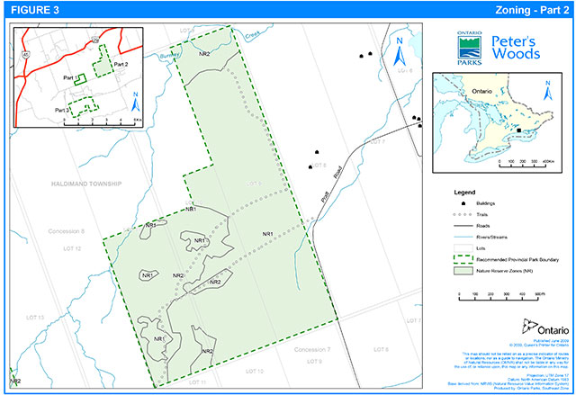
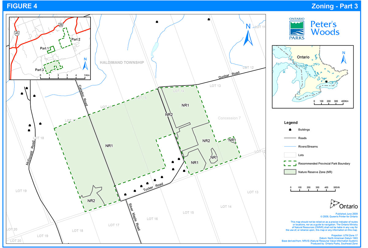
Areas within individual parks are identified as distinct zones for specific management purposes, in accordance with the significant features of the park and the level of protection required. Ontario Provincial Parks: Planning and Management Policies (MNR 1992) identifies the types of zones that may be applicable for each park class. For each type of zone, there are established policies for permissible management, use and development practices. Nature reserve class parks have three possible zone types: nature reserve (NR), historical (HI) and access (A). Two of these zone types are utilized for this park. There are three (3) zones in total as illustrated in Figures 2, 3 and 4: two nature reserve zones and one access zone. Each zone type permits certain land uses and is managed in accordance with specific strategies. As a whole, the zones are designed to fulfill the goal and primary objective of the park.
It may be necessary to delineate some zone boundaries more precisely on the ground, and this will be done as required and as resources are available.
The following sections briefly describe each distinct zone. All resource management and recreational uses and facility development will be subject to standard legislation and policies governing provincial parks, as well as the park specific policies in Sections 8, 9 and 10.
7.1 Nature reserve zones
Nature reserve zones protect the inherent values of provincially significant natural features, they contribute to the environmental diversity of the park and the protected area system, and they allow for the potential of scientific research and public appreciation. These zones include any significant earth and life science features that require management distinct from that in adjacent zones, as well as a protective buffer with an absolute minimum for development. The main priority for nature reserve zones is protection, with some types of research and other uses being permitted. Only limited low-impact activities (e.g., hiking, nature appreciation) and scientific research may be permitted. Such activities would be subject to site evaluations to ensure that these activities are not leading to degradation of flora and fauna within the zone. Development will be minimal, and may include signs and trails. The park’s two nature reserve zones include approximately 99.7 percent of the total park area.
The park’s nature reserve zones are generally described below. These zones have been delineated based on their current and / or potential vegetation and their management needs. Vegetation communities for each zone are listed and described in more detail in Appendix A. Vegetation communities in Part 1 of the park are more fully described in Peter’s Woods Ecological Survey, Monitoring and Stewardship (Brdar 2005).
7.1.1. Zone NR1
(Prairie and Savannah Habitat) (255 ha)
This zone occurs within all three parts of the park, in various levels of quality.
The highest quality savannah and prairie areas within the park are found within Part 2. In these areas there are relatively few non-native species that have been planted or become established. Open grown black oaks dominate the canopy. The understory is dominated by regenerating black oak, fragrant sumac (Rhus aromatica), snowberry (Symphoricarpos albus), New Jersey tea (Ceanothus americanus), poverty oat grass (Danthonia spicata), long-fruited anemone (Anemone cylindrica) and Pensylvanica sedge (Carex pensylvanica).
Part 2 also includes moderate quality areas. These vegetation communities include oak-pine mixed forest, dry tallgrass prairie and sand barren. Some Scots pine (Pinus sylvestris) are present, but the majority of the area is dominated by open grassland with native prairie or savannah species.
Lower quality savannah characterizes approximately half of Part 3 and pockets within Part 2. This community is dominated by a mixture of native and non-native species. Vegetation communities are predominantly plantation and cultural woodland, with some cultural meadow, cultural savannah, mixed forest, and deciduous forest. These areas are dominated by Scots pine but have tallgrass species scattered throughout the understory. The tallgrass species include fragrant sumac and New Jersey tea.
In Part 1, this zone is a lower quality grassland community identified as Dry Black Oak – Pine Savannah - a pocket of dry rolling upland with scattered white pine and Scots pine. The ground cover includes remnant prairie species like butterfly milkweed (Asclepias tuberose).
Lower quality prairie and savannah habitat is also found within Parts 2 and 3 of the park. Scots pine and red pine have been planted in high concentrations in this area. Native species are present but in lower numbers. Tallgrass or other native species are uncommon. The understory and ground cover in these communities is very limited as the planted tree species are dense and thinning has not occurred. If there is any regeneration it is of the non-native canopy species such as Scots pine or red pine.
Within Parts 2 and 3 of the park, there are several existing, interconnected trails that cross through parts of this zone (Figures 3 and 4).
7.1.2. Zone NR2
(Forest Communities) (102 ha)
Within Parts 2 and 3 of the park, this zone is a mix of lowland forest, eastern hemlock (Tsuga canadensis) forest and wetland. Wetland areas include coniferous swamp, thicket swamp, mixed swamp, and meadow marsh. Lowland forest includes red maple (Acer rubrum) - white pine mixed forest, hemlock mixed forest, white cedar (Thuja occidentalis) hardwood forest.
Within Part 1 of the park, this zone includes four distinct natural forest communities: older-growth sugar maple deciduous forest, mature hemlock mixed forest, mid-age white pine – oak mixed forest, and mid-age poplar – white birch deciduous forest. It is characterized by rich woods on rolling uplands dissected by streams, woods on flat uplands and a lowland drainage area. The older-growth maple-beech forest on dry to mesic sandy soils is representative for Ecoregion 6E, and is in good condition. There are very few such stands existing in the provincial protected areas system (Brdar 2005).
This zone within Part 1 of the park also includes a small area that is generally flat upland with a mixed plantation of white pine and Scots pine and a patchy understory of sugar maple, white ash and American basswood (Tilia Americana). The community type is best described as a White Pine Coniferous Plantation, although natural succession to deciduous forest is occurring. This area is between access zone A1 and the older-growth forest community and was formerly agricultural land.
The existing hiking trail in Part 1 of the park is within this zone.
7.2 Access zones
Access zones are intended to serve as staging areas for access to the park and to provide for and regulate use. Limited facilities for research and for park management may also be present.
7.2.1. Zone A1
(1.0 ha)
This zone consists of the existing entrance road and parking area within Part 1 of the park. The hiking trail originates within this zone. The park entrance road is within a 15 m road right of way.
Based on the low use of Parts 2 and 3 of the park (the Burnley-Carmel addition), active resource management prescriptions and the need to limit use to protect significant features, an additional access zone is not proposed for this property.
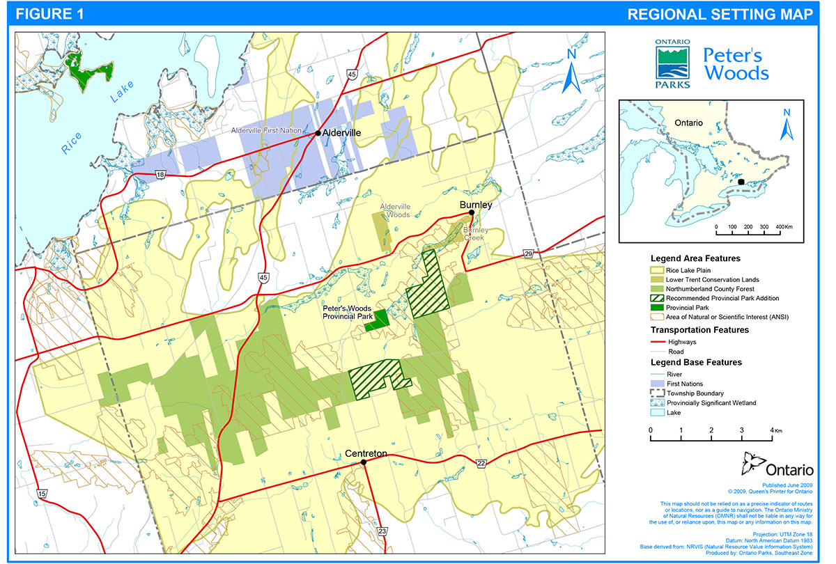
Figure 2: Zoning - Part 1
Enlarge Figure 2: Zoning- Part 1
Figure 3: Zoning - Part 2
Enlarge Figure 3: Zoning - Part 2
Figure 4: Zoning - Part 3

Enlarge Figure 4: Zoning - Part 3
8. Resource Management Policies
Peter’s Woods Provincial Park will be managed in accordance with the policies as set out in Ontario Provincial Parks: Planning and Management Policies (1992) for nature reserve class parks. The following policies will guide the management of park resources consistent with the Endangered Species Act and the Provincial Parks and Conservation Reserves Act and with the requirements of the Environmental Assessment Act. All resource management projects will be undertaken consistent with A Class Environmental Assessment for Provincial Parks and Conservation Reserves (Class EA PPCR).
Resource management initiatives may be accomplished through partnerships.
An adaptive management approach will be applied to resource management activities within the park. Adaptive management allows for frequent modification of management strategies in response to monitoring and analysis of the results of past actions and experiences. Adaptive management is a systematic, practical approach to improving resource stewardship.
The aim of management and restoration in nature reserve zones will be to perpetuate the natural heritage values which the zone has been established to protect. Management and restoration will generally mean maintaining or restoring the ecological integrity of natural environments, at which point those environments will be left to evolve naturally and without human interference, except as specifically prescribed in this plan or subsidiary implementation plans. In some cases, continuing active management to maintain a particular habitat condition or stage of natural succession (for example, an old field) may be justified if it contributes to the park’s overall biodiversity.
Natural processes will be used except where other approaches are specifically prescribed by this plan. Priority will be given to restoration techniques that are judged to be most likely to succeed and to have the most substantial positive impact relative to cost. Visitor education will be fundamental to successful implementation. Appropriate scientific research and monitoring of the park’s ecological processes will also be encouraged.
8.1 Industrial / commercial uses
The following uses are not permitted in Peter’s Woods Provincial Park:
- Commercial timber harvest
- Prospecting, staking of mining claims, developing mineral interests, working mines
- Extraction of aggregate (e.g. sand, gravel), topsoil or peat
- Generation of electricity
- Other industrial uses
- Commercial harvesting, including trapping, fishing and baitfishing (there are no existing licences; new operations will not be considered)
8.2 Land and water
The landforms and water features present do not require specific management activities.
There are a few existing private licenced aggregate pits in the park area, however none are located within or directly adjacent to the park boundary. The Oak Ridges Moraine Conservation Plan prohibits pits within the "Natural Core Area", which includes some of the lands directly adjacent to the park. Natural environment concerns will be considered through the review process under the Aggregate Resources Act and also as required by the Oak Ridges Moraine Conservation Plan.
8.3 Vegetation
Except where there is a threat to public safety, threat from invasive species or as required for management actions approved by this section of the plan, dead trees will be left standing, and if cut or when they fall on their own, they will be left where they fall.
Trees and brush may be cut or pruned to enable resource management authorized by this plan or a subsidiary implementation plan or to ensure public safety.
Populations of rare and significant plant species may be periodically monitored to ensure their continued health. Specific enhancement or re-introduction programs may be developed where appropriate. Alien or non-native plant species will not be intentionally introduced and will be controlled if they are shown to be negatively affecting the health of native species. Control of invasive species will follow the direction in the South Eastern Zone Invasive Exotic Plant Management Strategy (Ontario Parks 2003), Peter’s Woods Ecological Survey, Monitoring and Stewardship (Brdar 2005) and the policies of this plan. Insect or disease control will occur only where there is a threat to the park’s natural features.
Chemical fertilizers will not be used in the park. Chemical herbicides, pesticides and suppressants will not be used for any vegetation management purpose except for:
- insect and disease control and fire suppression under the conditions set out in this section of the plan
- eradication of non-native species where it has been demonstrated that other methods with less residual impact on the park’s environment are not feasible; and
- control of poison ivy (Rhus radicans) on trails (i.e. within Part 1) where necessary to ensure visitor health and safety
Where control is undertaken, it will be directed as narrowly as possible to the specific species so as to have minimal effects on the rest of the park’s environment.
The restoration of degraded environments will be given a high priority. The park includes numerous areas of Scots pine that are shading out tallgrass prairie plants and other native communities. Invasive non-native plants and lack of managed fire are two management issues that are in need of attention and for which policy is discussed below.
The park superintendent may close areas of the park during resource management activities.
In addition to the management prescriptions in Section 8.3.1 below, the details within the appendices of this plan will direct vegetation management activities within the park until a vegetation management plan is developed.
8.3.1. Management prescriptions
Vegetation communities have been inventoried and classified according to the Ecological Land Classification of Southern Ontario (ELC) protocol (Lee et al 1998). Field investigations conducted on the property have identified 31 vegetation community types. These community types are listed and described in detail in Appendix 1.
The community types can be grouped into six community classes: cultural; forest; tallgrass prairie, savannah and woodland; marsh; sand barren; and swamp. These community classes are more fully described in Appendix 2. The definitions of tallgrass prairie and oak savannah follow that as put forth by Lee et al. (1998). When areas did not fit within the given definition, notes were made to document this. Vegetation communities within Part 1 of the park are described in further detail in Peter’s Woods Ecological Survey, Monitoring and Stewardship (Brdar 2005).
Tall grass prairie and savannah require active management to remove and control native and non-native woody stems, grasses and forbs that compete with the rare native prairie species. A variety of techniques have been used at other sites. The following techniques have been considered for use at Peter’s Woods and are recommended for use singly or in combination: prescribed burning, woody stem cutting, artificial fuel, herbicides, mowing, and seeding. These techniques are described in detail in Appendix 3. Other techniques may present themselves in the future before the next review of this plan. If deemed appropriate for Peter’s Woods after careful consideration and application of environmental assessment requirements, they may be utilized.
Prescribed burning is the deliberate, planned and knowledgeable application of fire by authorized personnel to a specific land area to accomplish pre-determined objectives. Prescribed burning is an approach currently being used in several provincial parks in Ontario to restore prairie and savannah habitats. It is an approach being used within other lands in the Rice Lake Plains, including Alderville First Nation Reserve and Northumberland County Forest. Supporting the ecological role of fire in unique or threatened ecosystems is a management objective of the Forest Fire Management Strategy for Ontario (MNR 2004), which provides the following management direction: "Prescribed burning is recognized as a management tool with which to meet ecosystem renewal or hazard reduction objectives within this Zone [Southern Ontario Zone]."
Prairie and oak savannah restoration will occur within zone NR1 in stages throughout the 20 years of this plan, and prescribed burning will be the primary technique. Unless enhanced or alternative direction is required, plans for prescribed burning will be developed in accordance with the Forest Fire Management Strategy for Ontario, the MNR Prescribed Burn Policy and its associated MNR Prescribed Burn Planning Manual, in cooperation with Haliburton Fire Management Headquarters. In the Class EA PPCR, projects undertaking prescribed burning and conforming with the above direction have been assigned as a Category A project, and planning and implementation of these projects is allowed to proceed without further public review under the Class EA PPCR process. The first Category A project prescribed burn in Peter’s Woods occurred in spring of 2006 and involved approximately 13 ha of the park.
Active management to restore these areas may also consist of controlling non-native species (e.g., Scots pine). Depending on site quality, a higher level of work to control non-native species will be required in some areas in preparation for prescribed burning.
Management of plantation areas in zone NR1 and NR2 will require thinning of planted native pines (e.g. red pine, white pine) and thinning / clearing of the non-native Scots pine, which are acting as seed sources and increasing the amount of non-native species in the area. A plantation restoration plan will guide the amount of thinning in Parts 2 and 3 of the park. The intent of active management will be to return these communities to natural woodland.
Merchantable timber resulting from forest management may be removed. Winter would be the best time to remove the trees, so that snow cover prevents the ground layer from being disturbed, which will minimize potential for introducing non-native species.
In natural forest communities in zone NR2, natural processes will be allowed to continue. Non-native species will be monitored and controlled as necessary.
Detailed management prescriptions by vegetation community type are found in Appendix 2.
8.4 Inventory and monitoring
Planning and management decisions are intended to ensure the ecological sustainability of protected areas (which includes social and economic components).
Ontario Parks will ensure that these decisions are made with the best available information. Where this information is lacking, Ontario Parks may conduct inventories and monitoring, as necessary, to provide this information. Such efforts will be undertaken based on established methodologies and best practices.
This will foster an adaptive management approach to protected areas management. The following are broad approaches to identifying inventory and monitoring needs: management actions identified in this management plan, public input, routine park maintenance activities, staff knowledge and experiences and environmental scans.
Monitoring and data collection are essential to adaptive management at Peter’s Woods. Permanent monitoring sites, including transects and photo monitoring, have been established to allow for assessment of the effects of management. Monitoring programs that are presently in place and may continue are fully described in Appendix 4.
Priority monitoring projects include:
- Assessment of effects of active vegetation management (e.g. prescribed burning, plantation thinning / naturalization)
- Monitoring changes over time in older-growth forest heath and old field habitat succession
8.5 Forest fire management
MNR recognizes fire as an essential ecosystem process, fundamental to restoring and maintaining the ecological integrity of protected areas in the Deciduous Forest Region.
Fire management involves the protection of values and the attainment of resource stewardship objectives through two main areas:
- Fire response: The protection of people, property and natural areas from wildfire, and
- Fire use: The strategy of maintaining fire as an ecological process or meeting resource management objectives through the application or management of prescribed fire
The Forest Fire Management Strategy for Ontario (MNR, 2004) provides strategic direction for the management of wildfire across Ontario. Peter’s Woods Provincial Park is in the Southern Ontario Fire Management Zone according to this provincial strategy.
This fire management zone is located Outside the Fire Region (OFR). Municipalities have a mandate to provide forest fire protection on all lands outside the fire region. Municipalities have the lead in fire protection and management activities under the Fire Protection and Prevention Act (i.e. to protect human lives and properties) and through municipal by-laws. The Haldimand Township fire department is responsible for fire protection and response in the park area. Ontario Parks will pursue an agreement with the municipality for management of forest fires occurring within the park, in accordance with OMNR policy on Fire Management South of the Fire Regions (FM:2.04).
Fire management within Peter’s Woods Provincial Park will help to restore and maintain ecological integrity while preventing personal injury, value loss, and social disruption. In particular, fire management will help to:
- Perpetuate naturally occurring vegetation communities and their underlying ecological processes; and
- Enhance habitat for prairie and savannah flora and fauna (Section 8.3)
Fires that pose a threat to public health and safety, property and infrastructure, or other values are a priority for suppression. An agreement on fire suppression will be reached through consultation with the park superintendent, the Haldimand Township fire department and authorized MNR fire management personnel. MNR fire management personnel may support the Haldimand Township fire department in severe or extraordinary fire situations.
"Light on the land" fire suppression techniques will be addressed in the fire management agreement and used wherever feasible. These minimal impact suppression techniques do not unduly disturb natural values. Examples may include limiting the use of heavy equipment or the felling of trees during fire response.
In order to provide detailed direction on the use of fire to achieve ecological or hazard reduction objectives Ontario Parks will write a Statement of Fire Intent as directed by the Fire Management Policy for Provincial Parks and Conservation Reserves. This statement will be developed in consultation between the park superintendent and MNR fire management personnel.
Direction for prescribed burning within the park is provided in Section 8.3.1.
8.6 Wildlife management
Wildlife management will focus on achieving a healthy and diverse natural environment. Natural succession will be the primary means of achieving this objective.
Rare and significant wildlife species may be monitored periodically to ensure their continued health within the park. Protection and recovery plans may be implemented as necessary for the perpetuation of such species.
Animal populations or individual nuisance animals may be controlled when essential to protect human health and safety, the health of species outside the park, or the values for which the park has been established. Conflicts that have arisen between visitors and healthy native animals mainly due to visitor behaviour such as feeding and littering and not considered as endangering human health and safety will normally be dealt with through visitor education rather than animal control. When animal control is necessary, it will be subject to any environmental assessment requirements and techniques will be used that have minimal effects on other components of the park’s environment.
Appropriate methods of population control may be undertaken directly by Ontario Parks, or through partnerships under the supervision of Ontario Parks.
Reestablishment of native prairie plant species can be negatively affected by overbrowsing by wildlife. Ontario Parks will periodically assess the effects of white-tailed deer (Odocoileus virginianus) browse on vegetation in the park to determine whether management action is required. If research indicates that the number of deer in the area is a concern and control is necessary, Ontario Parks staff will work with Peterborough District MNR staff to determine deer management options in the surrounding landscape, and if necessary a resource management implementation plan (e.g., deer herd reduction plan) would be undertaken to determine management actions within the park in the context of the broader landscape.
8.7 Species at Risk
Species at risk will be protected consistent with the Endangered Species Act and regulations.
Populations of species at risk and rare plants will be monitored. The park may undertake management actions for species at risk as supported by research and directed through approved recovery plans or other species specific management plans.
Research by qualified groups or individuals that is related to protection of species at risk will be encouraged when it may aid in species protection and recovery (Section 9.3).
Extirpated native species may be reintroduced, and existing populations replenished, if ecologically feasible and acceptable, and desirable for perpetuating park values.
8.8 Non-native and invasive species
Non-native species means species not native to Ontario. Non-native species will not be deliberately introduced. Invasive species means species that are likely to spread and negatively affect native ecosystems. Where possible, actions will be taken to eliminate or reduce the threat of invasive species that may be affecting the diversity of naturally occurring populations. Where non-native species are already established and threaten natural or cultural values, a program of control may be undertaken if feasible and practical.
8.9 Cultural heritage values
There are no known archaeological sites within the park. Further study will be encouraged. Management strategies for any archaeological sites found in the future may range from allowing the site to evolve without human interference, to research, excavation, and rehabilitation. Strategies would be consistent with protection requirements of other significant features in the area. Protection and management will be undertaken in consultation with the Ministry of Culture and local First Nations and consistent with A Technical Guideline for Cultural Heritage Resources for Projects Planned Under the Class Environmental Assessment for MNR Resource Stewardship and Facility Development Projects and the Class Environmental Assessment for Provincial Parks and Conservation Reserves.
Significant cultural features will be protected from incompatible development wherever they occur in the park. Incompatible resource uses and recreational activities will be restricted or prohibited where necessary to protect significant cultural heritage values. Archaeological and historical artefacts may only be removed and heritage landscapes altered as part of approved cultural heritage research or management projects.
If an archaeological assessment is undertaken in the future, the zoning for the park may be modified if it is determined that any concentrations of cultural heritage sites require management different from that provided in current zoning.
9. Operations policies
The park will remain a non-operating provincial park. Wherever necessary, implementation of the policies stated below will be consistent with the approved Ontario Provincial Parks Minimum Operating Standards.
Self-serve facilities may be developed, and individual volunteers and partner organizations may be involved in park programs, to ensure that park operations continue to meet standards.
MNR staff may use mechanized vehicles (e.g. snowmobiles, motor vehicles) in the park to the extent necessary for efficient park management, resource management (e.g., prescribed burn) and operations. Where this use is necessary, consideration must be given to minimizing long-term damage to vegetation and other natural values. In approving research applications (Section 9.3), Ontario Parks may authorize researchers to use motor vehicles to the extent necessary for research to be conducted safely and efficiently. Both Ontario Parks' staff and approved researchers will conform wherever possible to the limitations applicable to recreational users, and will travel through the park on foot wherever possible. If deemed necessary, any other public agency may use any craft or vehicle for emergency rescues in the park, subject to the approval of the park superintendent. To reduce the risk of introducing non-native vegetation species to the park, mechanized vehicles used in the park interior for park resource management or operations should be washed prior to entering the park.
9.1 Recreation management
Permitted recreational uses within the park are based on the policies of Ontario Parks, which establish what recreational activities and facilities are appropriate in nature reserve class parks.
Hunting will not be permitted within the park. ATV use, snowmobiling, and horseback riding are some of the other recreational activities that are not permitted in Peter’s Woods.
Permitted day use recreational activities are listed below and are in accordance with the policies for nature reserve class parks as set out in Ontario Provincial Parks: Planning and Management Polices (1992):
- Canoeing / kayaking
- Cross-country skiing
- Hiking
- Historical appreciation
- Nature appreciation
- Painting / photography
- Picnicking (access zone)
- Snowshoeing
- Sport fishing
Fishing will be allowed within Burnley Creek in accordance with Ontario Fishery Regulations made pursuant to the Fisheries Act for those waters.
Water-based activities such as canoeing and kayaking will be allowed on Burnley Creek.
Trails in the park will be for pedestrian use. The maintained hiking trail within zone NR2 in Part 1 of the park will continue. This trail may be extended through the prairie and savannah area of zone NR1 in Part 1 if resource management prescriptions permit. Low intensity pedestrian use of trails within Parts 2 and 3 may continue, unless this use is determined to be negatively affecting significant values. Some of the trails in Parts 2 and 3 will be closed and used for resource management purposes (e.g. prescribe burns) or rehabilitated or left to regenerate naturally. Trails in Part 2 and 3 that will continue for pedestrian use may become maintained trails (Section 10.1). A section of new hiking trail may be created along the north boundary of Part 3 for the purposes of the Oak Ridges Trail (Section 10.1).
The objective of trail maintenance is to keep trails in an aesthetically pleasing and safe condition. Maintenance levels are based on the level of use. Where deemed necessary, surfaces such as crushed rock screenings or wood chips may be added to park trails to reduce compaction of soil, damage to exposed roots and the possibility of user injury. Maintained trails will be clearly marked and signed to reduce deviation from the main route. Boardwalks, bridges and stairs may be constructed along trails to assist with erosion control and to ease travel in difficult terrain.
In keeping with the park objectives, given the sensitivities of the site, limited facilities and active management prescriptions, promotion for ecotourism is not appropriate.
Appropriate signs will be placed at the boundary of the park to indicate its class, and may identify activities that are prohibited within the park. Closure of trails that originate from the road allowances will be necessary. Fencing or barriers may be used to control access at appropriate locations.
Vault privies may be replaced or installed within the access zone as needed and as funding permits.
Addition of Parts 2 and 3 to the park will not affect snowmobile travel along the authorized Ontario Federation of Snowmobile Clubs trails within the road allowance abutting the north boundary of Part 3 (linking to Dunbar Road) and south of Part 3; these road allowances will be excluded from the park boundary so there will continue to be snowmobile access through the general area.
9.2 Natural heritage education
Natural heritage education in provincial parks is intended to develop visitors' awareness and appreciation of Ontario’s natural and cultural heritage, fostering a commitment to protecting that heritage for all generations. Natural heritage education opportunities are meant to be educational and recreational, formal and informal, and accessible to all.
There are three components of natural heritage education in parks: information, interpretation, and outdoor recreation. The level of service that each park provides depends on its significance and visitation. At Peter’s Woods, heritage education is at the self-use, or minor activity level. Although information about the park and park system will be provided, the park does not have dedicated interpretive staff. Natural heritage education at the park will be consistent with the Southeast Zone Natural Heritage Education Strategy (Ontario Parks 2007 Draft).
9.2.1. Interpretation
Interpretation in Peter’s Woods will generally be low-key. Emphasis will be placed on interpreting the most significant natural features of the park and illustrating their importance within the context of the greater ecosystem. The self-guiding trail system with associated signage and trail guide publication will provide the medium for interpretation. Development of permanent information display panels, in cooperation with the Willow Beach Field Naturalists and NCC, will be considered when resources become available.
The main interpretive themes for Peter’s Woods will be:
- value and functioning of the older-growth forest
- prairie and savannah ecosystem / restoration
- vegetation succession (old fields); and
- Oak Ridges Moraine physiography
9.2.2. Information
The information focus of heritage education at Peter’s Woods will include, but not be limited to:
- describing the park, its natural features, facilities and management objectives, and pertinent rules
- facilitating understanding, appreciation and enjoyment of the older-growth forest and tallgrass prairie and savannah habitats
- increasing public awareness and understanding of prescribed burning, and the benefits of this management technique as a restoration tool for certain vegetation communities / types
- increasing public awareness of the issues related to non-native and invasive species
- increasing awareness of the objectives and benefits of nature reserve class provincial parks
- instilling in visitors a sense of respect for the park environment
- providing a way for park visitors and stakeholders to communicate with Ontario Parks; and
- providing emergency contact information
This will be achieved through publications, specifically the park brochure and trail guide, signage, an on-site guest book and informal public meetings with naturalists and other user groups. Feedback will allow for planning and management that is responsive to visitor needs and preferences that are appropriate to the park. This will also allow staff to assess visitor use, patterns and attitudes.
9.2.3. Outdoor recreation
Outdoor recreation will be focussed on low-intensity pedestrian travel on the trail within Part 1 of the park. Outdoor education field trips by small organized groups (e.g., schools, scouts) are permitted, so long as use is limited to trails. Small groups with particular interest in the resources of Peter’s Woods are especially encouraged.
9.3 Research
Research by qualified individuals that contributes to knowledge of natural and cultural history and to environmental and recreational management will be encouraged.
All research will be conducted by Ontario Parks, or authorized by Ontario Parks. Research projects will be administered through park policy directives and requires a research permit. Research must also meet all requirements under applicable provincial and federal legislation. Approved research and monitoring activities must be consistent with the research strategies of Ontario Parks and the MNR. Sites altered by research activities will be rehabilitated as closely as possible to their previous conditions.
The following general fields of research are particularly appropriate to Peter’s Woods and will be encouraged:
- landforms, vegetation, wildlife, and archaeology of the park
- evolution of the park’s landscapes in relation to natural processes and human activity
- ecological restoration and management in the park
- the status of species at risk and other rare species and communities; and
- optimal relationships between heritage protection and recreational enjoyment within the park
9.4 Partnerships
Formal partnership agreements may be established between Ontario Parks, First Nations and third parties. Partners will represent the local community, and local and provincial interests.
Partners will work with Ontario Parks to implement the approved park management plan and will follow provincial park policies and regulations.
9.4.1. Current partners
The Willow Beach Field Naturalists is a not-for-profit organization that has been a partner with the park for over 30 years. Since 1995, Willow Beach Field Naturalists has provided invaluable assistance in the maintenance of the park’s parking lot, trail, privies and general maintenance within Part 1 of the park, and assistance with the park interpretive guide. The organization has provided about 100 hours of volunteer work per year, and prepares a report annually on their activities.
In 2002, Ontario Parks and the Nature Conservancy of Canada purchased the 317 ha Burnley-Carmel property for addition to Peter’s Woods Provincial Park. The 46 ha Alderville Woods property located south of Rice Lake had been secured the previous year as part of a partnership between Lower Trent Conservation Authority and NCC. The County of Northumberland owns 1052 ha within the Rice Lake Plains. These large anchor properties, combined with smaller private properties, contain significant amounts of globally threatened prairie and savannah that are in need of restoration.
NCC took a leading role in bringing groups together to discuss partnerships and planning the needs and requirements for the protection and restoration of lands within the Rice Lake Plains. Discussions resulted in the signing of the Rice Lake Plains Joint Initiative (RLPJI) Memorandum of Understanding that took effect in September of 2003. Current partners in the initiative are Alderville First Nation, The Corporation of the County of Northumberland, Ganaraska Region Conservation Authority, Lower Trent Region Conservation Authority, The Nature Conservancy of Canada, Northumberland Land Trust and Ontario Parks. The goal of this partnership is the protection and enhancement of globally and provincially threatened tallgrass prairie and savannah within the Rice Lake Plains. To date, funding for a total of four years was applied for and received from the Oak Ridges Moraine Foundation.
NCC will have an active role in implementing the policies in this plan regarding Parts 2 and 3 (lands in NCC ownership), including vegetation management, prescribed burn planning and monitoring, fund raising, other monitoring and stewardship activities. Other partnerships may be formed to assist with implementation of policies within Parts 2 and 3 of the park, such as maintenance of existing trails (e.g. Oak Ridges Trail Association).
10. Development policies
All development undertaken by Ontario Parks, or by partners on its behalf, will comply with A Class Environmental Assessment for Provincial Parks and Conservation Reserves, and will be carried out in accordance with approved site and development plans that meet development standards for provincial parks.
Development within the access zone will be limited to the existing entrance road, gates, and parking area and vault privies, and may be maintained as necessary. Development within nature reserve zones will be limited to self-use, pedestrian, interpretive trails and associated fence crossing / viewing platforms. Fences along the park boundary will be maintained to discourage uses that could damage the park’s environment.
Any areas proposed for development will require prior assessment for significant cultural heritage features and natural values - such as species at risk or significant communities - to ensure these values are identified and protected.
10.1 Trails
In Part 1 of the park, the pedestrian trail may be extended within some areas of zone NR2 to create a trail into zone NR1 if resources and management prescriptions permit. The footprint of the trail within the older-growth deciduous forest community of zone NR2 will not be increased.
Within Parts 2 and 3, all or parts of the trails may be integrated into a modest network of hiking, snowshoeing and cross-country ski trails. This proposed network of trails will depend on local interest, the availability of funding and timing and extent of resource management activities (e.g. prescribed burning). This trail network will be designed to highlight the natural features of the park and to minimize its environmental impact. Access points for this trail network may be appropriate and would require amendment to the zoning plan for the park.
The Oak Ridges Trail (ORT) Association recently proposed the development of a section of new trail and the use of the existing hiking trails within Part 2 and Part 3 of the park as part of an extension to the Oak Ridges Trail, linking to the Northumberland County Forest. Sections of the ORT crossing through the park would be identified as being pedestrian use only, consistent with the policies for this nature reserve class park. This proposal may be permitted subject to evaluation through the Class EA PPCR.
Proposed locations and standards of development for new trails will be made available for public review and comment before the trails are built.
11. Implementation strategy
Park development, operations and resource stewardship will be contingent upon the availability of funding and unforeseeable changes in priorities or policy. Implementation of the management plan and operation of the park will meet the requirements of the Environmental Assessment Act, Environmental Bill of Rights, Provincial Parks and Conservation Reserves Act, Endangered Species Act, and other pertinent legislation.
All projects for park management, development and operation will be undertaken in accordance with the requirements of A Class Environmental Assessment for Provincial Parks and Conservation Reserves. Class EA PPCR evaluation and consultation requirements for the following Category B projects were met, coordinated with park management planning:
- a park boundary amendment (major amendment) for addition of Part 2 and Part 3 to the park (the 317 ha Burnley-Carmel property), and
- vegetation management consisting of plantation restoration and planting of native prairie and savannah seeds in restoration areas to increase plant species diversity (a recurring, ongoing project)
In the implementation of the approved management plan, Ontario Parks may pursue opportunities for partnerships involving other agencies and groups.
Unless otherwise identified in this document, implementation priorities may be established in subsidiary operating and resource stewardship plans. Preparation of these plans may involve an appropriate level of public consultation.
Implementation priorities include:
- undertake vegetation management in accordance with Section 8.3 (e.g., prescribed burning, removal of Scots pine)
- prepare a plantation restoration plan (with guidelines for thinning areas in zone NR4)
- initiate MNR land use amendment and regulation process for recommended park additions
- install fencing, barriers, gates and signs as required
- develop suitable interpretive materials
- prepare a trail management strategy
- establish a Forest Fire Management Agreements
12. Plan amendment and review
The management plan can be reviewed or amended to address changing issues or conditions as necessary. At ten year intervals, this plan will be examined for the need for a review or amendment. A review may involve a reassessment of all or part of the plan, including classification, zoning, goal, objectives and all resource management, operations and development policies. An amendment can be considered to address specific issues or needs.
13. Consultation
Ontario Parks has carried out consultation with government agencies, other ministries, First Nations, interest groups and the public throughout this management planning process.
Class EA consultation requirements were coordinated for some projects (Section 11).
The methods of consultation utilized during release of park management planning documents were as follows:
Mailing lists
Mandatory Mailing List – as per Provincial Park Policy (PM 11.02.02)
Individuals / groups / agencies that responded to the Invitation to Participate
New individuals / groups who request to be added to the mailing list at any stage
Newspaper advertisements
Newspaper advertisements or notices were placed in the following newspapers:
Peterborough Examiner
Cobourg Daily Star
Brighton Independent
Campbellford Community Press
Environmental registry
Policy proposal notices posted on this website advertised the opportunities for the public review.
Ontario government
All planning documents were available at the Ontario Parks Southeast Zone office in Kingston, and the MNR Peterborough District Office.
13.1 Invitation to participate (stage 1)
Public and First Nation involvement in the development of the management plan for the park began in August of 2004, with the mailing of the invitation to participate to First Nations, individuals and groups believed to have an interest in this project. The invitation announced a 45 day opportunity for public review and comment on the terms of reference for the project. Of a total of 14 respondents, 12 confirmed interest in the project and / or submitted comments on the management planning process during this stage. Specific comments submitted during this stage related to the following issues: park classification, cultural resource protection, tallgrass prairie restoration, recreational use, and securement of adjacent lands.
13.2 Background information and issues and optional approaches (stage 2)
A background information file and an issues and optional approaches summary document was released in mid-June of 2005. The background information file was available for review in government offices in Kingston and Peterborough and at the Cobourg Public Library. About 180 copies of the issues and optional approaches summary document and an accompanying questionnaire were distributed by mail to individuals and groups on the project mailing list. The document proposed a classification and zoning policy for the park; summarized the most important planning and management issues that had been identified; and proposed policy options for these issues. Respondents were invited to submit comments to Ontario Parks by August 13, 2005. A total of 19 responses were received, including 16 completed questionnaires. Six respondents were members of or represented the interests of a specific interest group or municipality.
The questionnaire identified four management issues and requested comments on these specific issues:
- protection of natural values (zoning) – based on responses there was:
- slightly higher support for maintaining one access zone
- differing opinions on nature reserve park classification and zoning – some respondents expressed support, while others expressed concern
- restoration of oak savannah and prairie habitats – majority supported active management where necessary (e.g. prescribed burning, invasive species control)
- recreational activities – support received for all options (leave trails as is, and develop new hiking trails); and
- ecotourism – majority supported no active promotion of this park in the media
13.3 Preliminary park panagement plan (stage 3)
The preliminary park management plan was released on November 29, 2007 followed by a 46 day comment period. A local open house was held during the comment period. The preliminary park management plan included a summary of comments received during the previous stage of the project, and Ontario Parks' proposed preferred policies for park classification, goal and objectives, boundary, zoning, resource management, operation and development. A total of 14 responses were received regarding the proposed policies. Four responses were from representatives of interest groups. Six respondents stated support in general for the preliminary park management plan. The policy most commented on was the proposed addition of lands to the park, and specifically their nature reserve classification and the restrictions this places on recreational use. Comments both in support of (8) and stating concern or opposition to this policy (4) were received.
Several respondents stated concern or opposition to nature reserve park classification of the Burnley-Carmel lands and questioned the rationale for this classification and/or noted that this classification would result in conflicts as a result of different recreational uses within the park from those within the adjacent Northumberland County Forest. Ontario Parks and NCC recognize that there will be differing recreational uses on adjacent lands and will work with adjacent landowners to clearly mark and sign boundaries and communicate information about permitted uses. Class EA requirements for adding these lands to the park boundary were met, coordinated with the management planning process. The policy regarding nature reserve classification of these lands was not changed, however some clarification was added to the plan to address the main concerns that were stated:
- The rationale for nature reserve classification of Parts 2 and 3 of the park was clarified in Section 3.0 (much of this information was within the consultation section of the preliminary park management plan)
- NCC's ownership of Parts 2 and 3 of the park was clarified in Section 6.0
- NCC's role in implementing policies in this plan was added to Section 9.4.1, and the potential for other partner assistance was noted
- Acknowledgement that the park boundary addition would not affect motorized use along the OFSC snowmobile trail along road allowances adjacent to the park was added to Section 9.1
- Text reflecting Ontario Parks' policies for securement of lands was added to Section 6.0
Review of the preliminary park management plan resulted in other minor wording changes to clarify policies; format changes were also completed based on current document standards for final park management plans (e.g. section layout and numbering).
14. Key references
Brdar, C.L. 2005. Peter’s Woods Ecological Survey, Monitoring, and Stewardship. Ontario Parks, South Eastern Zone, Ministry of Natural Resources.
Brownell, V.R., and C.S. Blaney. 1995. Lower Trent Region Natural Areas - Volume 1: A Biological Inventory and Evaluation of 20 Natural Areas in the Lower Trent Region, 1994. Lower Trent Region Conservation Authority, Trenton, Ontario.
Chapman, L.J. and D.F. Putnam. 1984. The Physiography of Southern Ontario; Ontario Geological Survey, Special Volume 2. Government of Ontario, Ontario. 270p.
Hoffman, D. W. and C. J. Acton. 1974. The Soils of Northumberland County Report No. 42 of the Ontario Soil Survey. http://sis.agr.gc.ca/cansis/publications/on/on42/ [Link no longer active]. Ontario Ministry of Agriculture and Food, Toronto, Agriculture Canada, Ottawa Canada.
Horn and Horn. 1996. Quantitative Photo monitoring for Restoration Projects. Restoration and Management Notes.14 (1):30-34.
Imrie, A.L. 2006. Peter’s Woods: Prescribed Burn Vegetation Monitoring. Ontario Parks, Southeastern Zone, Ministry of Natural Resources, Kingston. Unpublished report. 38 pp.
Larson, B. M. et al. 1999. Woodland Heritage of Southern Ontario A Study of Ecological Change, Distribution and Significance. Federation of Ontario Naturalists Don Mills, Ontario.
Lee, H.T., W.D. Bakowsky, J. Riley, J. Bowles, M. Puddister, P. Uhlig and S. McMurray. 1998. Ecological land classification for Southwestern Ontario: first approximation and its application. Ontario Ministry of Natural Resources, South Central Region, Science Development and Transfer Branch. Technical Manual ELC-005.
Lindsay, K.M. 1984. Life Science Areas of Natural and Scientific Interest in Site District 6-7: A Review And Assessment of Significant Natural Areas in Site District 6-7. Ontario Ministry of Natural Resources, Central Region, Richmond Hill, Ontario. SR OFER 8410. viii + 77 pp. + maps.
Ministry of Municipal Affairs and Housing. 2002. Oak Ridges Moraine Conservation Plan. http://www.mah.gov.on.ca/userfiles/HTML/nts_1_6846_1.html [Link no longer active]
Natural Heritage Information Centre (NHIC). 2003. Provincial status of plants, wildlife and vegetation communities database. OMNR, Peterborough.
Nature Conservancy of Canada. 2004. Restoration Baseline of Tallgrass Prairie Communities in Burnley Carmel Natural Area. Unpublished report. 6 pp.
Newmaster, S.G., A. Lehela, P.W.C Uhlig, S. McMurray and M.J. Oldham. 1998. Ontario Plant List. Ontario Ministry of Natural Resources, Ontario Forest Research Institute, Sault Ste. Marie, ON, Forest Research Information Paper No. 123. 550 pp. + appendices.
OMNR. 2006. A Technical Guideline for Cultural Heritage Resources for Projects Planned Under the Class Environmental Assessment for MNR Resource Stewardship and Facility Development Projects and the Class Environmental Assessment for Provincial Parks and Conservation Reserves. Ontario Ministry of Natural Resources. 40p.
OMNR. 2005. A Class Environmental Assessment for Provincial Parks and Conservation Reserves. Ontario Ministry of Natural Resources, Queen’s Printer for Ontario. 120 p.
OMNR. 2005. Our Sustainable Future. Ontario Ministry of Natural Resources, Queen’s Printer for Ontario, # p.
OMNR. 2004. Forest Fire Management Strategy for Ontario. Ontario Ministry of Natural Resources, Queen’s Printer for Ontario, Toronto. 64 p.
OMNR. Prescribed Burn Planning Manual. Ontario Ministry of Natural Resources. AFFMB Publication No. 313. 98 p.
OMNR. 1992. Ontario Provincial Parks: Planning and Management Policies (1992 Update).
OMNR. 1989. Peter’s Woods Provincial Nature Reserve – Background Information Package. Lindsay District.
OMNR, Aurora District, Peterborough District and Midhurst District. June 2001. Natural Heritage Features of the Oak Ridges Moraine. Ontario Ministry of Natural Resources, Aurora District, Aurora, Ontario. 161 pp.
OMNR. 1983. Lindsay District Land Use Guidelines. Ontario Ministry of Natural Resources. 65 pp.
Ontario Parks. 1997. A Research and Information Strategy. Part One: Setting Priorities. 20 pp.
Ontario Parks. 2007 (Draft) Southeast Zone Natural Heritage Education Strategy. Unpublished report.
Stabb, M. 1996. Ontario’s Old Growth – A Learner’s Handbook. Canadian Nature Federation and Ancient Forest Exploration and Research. 47 pp.
Traill, Catharine Parr. 1989 (reprint). The Backwoods Of Canada. McClelland and Steward Inc. Toronto. 302 p.
Appendix 1. Vegetation communities within Peter’s Woods
Vegetation communities within Peter’s Woods according to Ecological Land Classification for Southern Ontario are listed in Table 1 below and illustrated in the figures. Approximate area in ha is based on digital mapping. A description for each community unit is found in Table 2.
Table 1. Peter’s Woods Vegetation Types
Cultural (136.9 hectares)
| ELC Community Class | ELC Vegetation Community Unit Code | ELC Vegetation Type | Approximate Area (ha) | Park Zone |
|---|---|---|---|---|
| CUM1-1 | Mineral Cultural Meadow Type | 12.7 | NR1 | |
| CUP3-1 | Red Pine Coniferous Plantation Type | 11.3 | NR1, 2 | |
| CUP3-2 | Mixed Pine Coniferous Plantation Type | 4.1 | NR2 | |
| CUP3-3 | Scotch Pine Coniferous Plantation Type | 68.3 | NR1, 2 | |
| CUP3-8 | White Spruce Coniferous Plantation Type | 3.4 | NR1 | |
| CUS1 | Mineral Cultural Savanna Ecosite | 2.9 | NR1 | |
| CUW1 | Cultural Woodland Ecosite | 34.2 | NR1 |
Forest (182.7 hectares)
| ELC Community Class | ELC Vegetation Community Unit Code | ELC Vegetation Type | Approximate Area (ha) | Park Zone |
|---|---|---|---|---|
| FOC3-1 | Fresh Moist Hemlock Mixed Forest Type | 7.7 | NR2 | |
| FOD2-4 | Dry Fresh Oak Hardwood Deciduous Forest Type | 6.5 | NR1 | |
| FOD3 | Dry-Fresh Poplar-White Birch Deciduous Forest Ecosite | 3.5 | NR2 | |
| FOD3-1 | Dry-Fresh Poplar Deciduous Forest Type | 13.7 | NR1, 2 | |
| FOD4 | Dry-Fresh Deciduous Forest Ecosite | 1 | NR2 | |
| FOD5-1 | Dry-Fresh Sugar Maple Deciduous Forest Type | 8.6 | NR2 | |
| FOD8-1 | Fresh Moist Poplar Deciduous Forest Type | 21.1 | NR1, 2 | |
| FOD9-2 | Fresh-Moist Oak-Maple Deciduous Forest Type | 4.7 | NR2 | |
| FOM1 | Dry Oak-Pine Mixed Forest Ecosite | 77.9 | NR12 | |
| FOM2-1/2 | Dry-Fresh White Pine-Oak/Maple Mixed Forest Type | 5.7 | NR2 | |
| FOM2-2 | Dry fresh Red Maple-White Pine Mixed Forest Type | 12.7 | NR2 | |
| FOM3-1 | Dry-Fresh Hardwood-Hemlock Mixed Forest Type | 1.6 | NR2 | |
| FOM6 | Fresh-Moist Hemlock Mixed Forest Ecosite | 6.9 | NR2 | |
| FOM7-2 | Fresh Moist White Cedar Hardwood Mixed Forest Type | 11.1 | NR2 |
Marsh
| ELC Community Class | ELC Vegetation Community Unit Code | ELC Vegetation Type | Approximate Area (ha) | Park Zone |
|---|---|---|---|---|
| Marsh | MAM3-1 | Bluejoint Organic Meadow Marsh Type | 4.2 | NR2 |
Sand Barren
| ELC Community Class | ELC Vegetation Community Unit Code | ELC Vegetation Type | Approximate Area (ha) | Park Zone |
|---|---|---|---|---|
| Sand Barren | SBO1 | Open Sand Barren Ecosite | 3.4 | NR1, 2 |
Swamp (12.3 hectares)
| ELC Community Class | ELC Vegetation Community Unit Code | ELC Vegetation Type | Approximate Area (ha) | Park Zone |
|---|---|---|---|---|
| SWC2-2 | Hemlock Mineral Coniferous Swamp Type | 5.0 | NR2 | |
| SWC4-2 | Tamarack-Black Spruce Organic Coniferous Swamp Type | 2.3 | NR2 | |
| SWD7-1 | Birch Poplar Organic Deciduous Swamp Type | 0.9 | NR2 | |
| SWM4 | White Cedar Organic Mixed Swamp Ecosite | 2.4 | NR2 | |
| SWT3-2 | Willow Organic Thicket Swamp Type | 1.7 | NR2 |
Tallgrass Prairie, Savannah and Woodland (19.6 hectares)
| ELC Community Class | ELC Vegetation Community Unit Code | ELC Vegetation Type | Approximate Area (ha) | Park Zone |
|---|---|---|---|---|
| TP01-1 | Dry Tallgrass Prairie Type | 0.5 | NR1 | |
| TPS1-2 | Dry Black Oak-Pine Tallgrass Savannah Type (degraded) | 5.2 | NR1 | |
| TPW1-1 | Dry Black Oak-White Oak Tallgrass Woodland Type | 13.9 | NR1 |
Figure 5: Vegetation Communities - Part 1
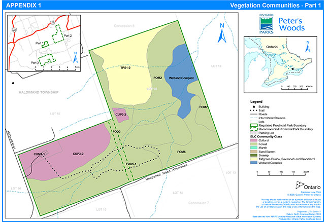
Enlarge Figure 5: Vegetation Communities - Part 1
Figure 6: Vegetation Communities - Part 2
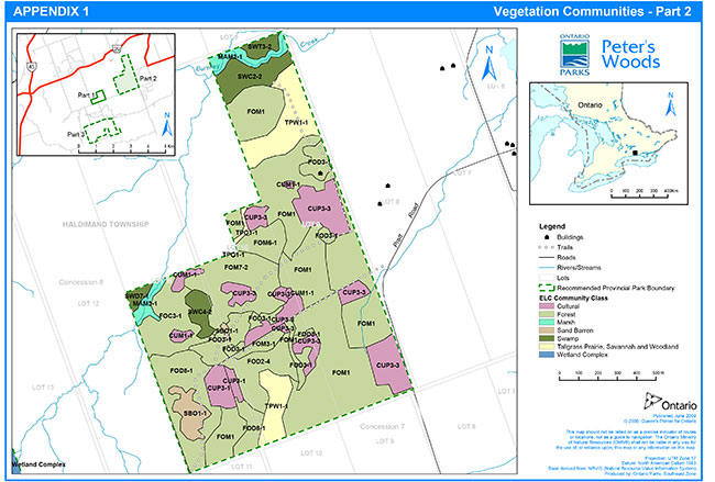
Enlarge Figure 5: Vegetation Communities - Part 2
Figure 7: Vegetation Communities - Part 3
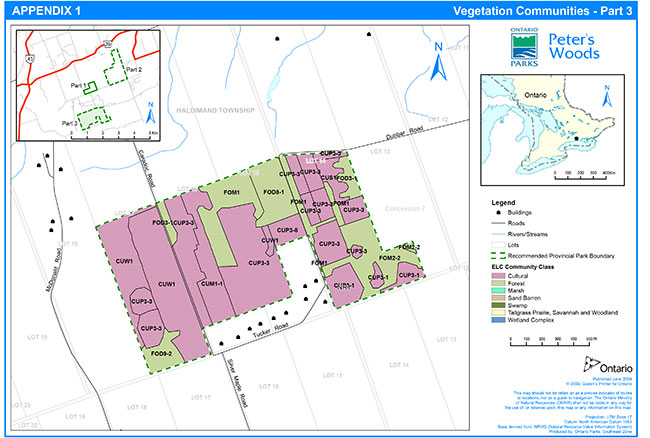
Enlarge Figure 5: Vegetation Communities - Part 2
Table 2: Description of ELC Community Units
| ELC Community Unit | Dominant Species | Description |
|---|---|---|
| CUM1-1 Dry-Moist Old Field Meadow Type |
Canopy Quercus velutina Populus tremuloides Sub-Canopy Pinus sylvestris Shrub Comptonia peregrina Herb Centaurea sp. Graminoides Pteridium aqulinum Fragaria sp. |
There are scattered trees in the community which are less than 10 m tall, they constitute less than 10% of the cover and <10 cm DBH.. The Sub canopy is 1-3 m tall and has <10% cover. The shrub layer is dominated by sweet-fern (Comptonia peregrine) with poison ivy and raspberry (Rubus sp.). The cover is 10-25% and 0.5-1 m in height. The herb layer is the dominant feature of this community with 80-100% cover. Scots pine are seeding into this area from the adjacent plantation. Some of the substrate has been moved, creating mounds of dirt and woody debris. |
| CUP3-1 Red Pine Coniferous Plantation Type |
Canopy Pinus resinosa Shrub Rhus radicans (A) Rubus sp. (A) Herb Pteridium aqulinum (D) |
This red pine plantation is uniformly closed with 80-100% cover. There has been some thinning done in the past. There is moderate regeneration cover dominated by large-tooth aspen (Populus grandidentata), black oak, with some white oak, red pine and Scots pine also present. The shrub layer cover is 25-60% with abundant poison ivy and raspberry. The herb layer cover is 25-60% and patchy. |
| CUP3-2 White Pine Coniferous Plantation Type |
Canopy Pinus strobus Pinus sylvestris Sub-Canopy Acer saccharum Fraxinus Americana Tillia americana Herb Solidago sp. Rubus sp. Graminoides |
This is a mixed pine plantation over former disused agricultural land. White pine canopy more closed than Scots pine; spacing, DBH, and regeneration variable. Gaps dominated by Solidago and Rubus sp. Not described well by ELC. One older P. strobus stand (<1 ha). Patchier through Lot 14 than in Lot 15. |
| CUP3-3 Scotch Pine Coniferous Plantation Type | Canopy Pinus sylvestris Shrub Rhus radicans Shepardia canadesis (A) Comptonia peregrina Ceanothus herbaceous Herb Pteridium aquilinum Graminoides |
There are two areas of this community:
|
| CUP3-8 White Spruce Coniferous Plantation Type |
Canopy Picea glauca Shrub Rhus radicans Comptonia peregrina Herb Pteridium aquilinum Hieracium sp. |
This dense white spruce (Picea glauca) plantation has a cover of 80-100%. The spruce is dominant with a few large-tooth aspen and balsam poplar (Populus balsamifera). The regeneration is low with some black cherry. The shrub and herb layer cover are both less than 10%. Bryophytes make up most of the round cover with 25-60% cover. |
| CUS1 Mineral Cultural Savannah Ecosite |
Canopy Populus tremuloides Quercus velutina Pinus sylvestris Prunus pennsylvanica Shrub Rhus typhina Herb Graminoids – A Hieracium sp. – A |
This community was previously a plantation that was cleared and left to regenerate. The site has a patchy canopy cover of about 30%. The shrub cover is 25-60% and dominated by poison ivy though there is some sweet fern and New Jersey tea. The ground layer is 25-60% covered with graminoides and hawkweeds as the most abundant, but butterfly milkweed was also found. The ground layer space that remains is covered by lichens (25-60%). |
| CUW1 Cultural Woodland Ecosite |
Canopy Pinus sylvestris Betula papyrifera Sub-Canopy Prunus serotina Fagus grandiflora Quercus rubra |
This area was planted with Scots pine and is regenerating into a woodland community. The canopy closure is variable (40-70%). The sub canopy is 3-5 m tall with 60% closure. The regeneration is moderate and 1-3 m tall with black oak, white ash, black cherry and white oak. The shrub layer is dense (80-100%) and the ground layer has a 25% cover. The community is very patchy with a few inclusions. One inclusion is dominated by trembling aspen with oak and white birch. Another inclusion has hawthorns, red and black oak, red maple and ash. |
| CUW1 Cultural Woodland Ecosite (continued) |
Shrub Rhus radicans Rubus sp. Herb Maianthemum racemosa Pteridium aquilinum |
This area has potential to become a good tallgrass community |
| FOC3-1 Fresh-Moist Hemlock Coniferous Forest Type |
Canopy Tsuga canadensis (L) |
Hemlock dominated with cedar, white pine and trembling aspen. |
| FOD2-4 Dry-Fresh Oak- Hardwood Deciduous Forest Type |
Canopy Quercus velutina Populus tremuloides Shrub Quercus velutina Rhus radicans |
This community is on the tableland and is dominated by black oak with sugar maple, trembling aspen and large-tooth aspen in the canopy. The canopy is 70-80 % cover with regenerating black oak, and sugar maple and poison ivy in the understory. Currently an FOD but was a TPW1 based on the species that are present. |
| FOD3 Dry-Fresh Poplar- White Birch Deciduous Forest Ecosite |
Canopy Betula papyrifera Populus tremuloides Fraxinus americana Sub-Canopy Acer saccharum saccharinum Fraxinus Americana C. cordiformis |
Mainly flat uplands. Successional forest found associated with hedgerows and forest edges – cover varies. Limited to edges of main communities. |
| FOD3-1 Dry - Fresh Poplar Deciduous Forest Type |
Canopy Populus tremuloides Betula papyrifera Populus grandidentata Sub-Canopy Quercus rubra Quercus velutina Prunus serotina Shrub Prunus virginiana Rhus radicans Cornus rugosa Rubus sp. Ceanothus americanus Rhus aromatica Herb Graminoides Maianthemum racemosa Centaurea nigrescens ssp. nigrescens (Note: dominant species vary for each area) |
There are four separate areas of this community:
|
| FOD4 Dry-Fresh Deciduous Forest Ecosite |
Canopy Populus grandidentata Prunus serotina Subcanopy Acer rubrum Shrub Rhus radicans Cornus rugosa Herb Graminoides |
This early aged forest has a canopy with low closure (10-25%) and a very dense sub-canopy (80-100%). The canopy is dominated by large-tooth aspen with some black cherry and the sub-canopy is dominated by young red maple with some sugar maple, white oak and black cherry with a DBH <10 cm. There was logging activity in the past from the many obvious stumps and suckering Red Maples. The bark of the stumps appears to be balsam poplar. Shrub cover density is around 25% and dominated by poison ivy and roundleaf dogwood (Cornus rugosa). The ground layer coverage is 25 – 60% and is dominated by a grass species with some Wintergreen, Hairy Solomon Seal and Star Flower. |
| FOD5-1 Dry-Fresh Sugar Maple Deciduous Forest Type |
Canopy Acer saccharum Quercus rubra Pinus strobes Fraxinus grandifolia Fraxinus americana Subcanopy Acer saccharum Fraxinus grandifolia Betula papyrifera Shrub Herb |
Rich woods on rolling uplands dissected by streams. Special feature is older- growth forest; basal area up to 40. |
| FOD8-1 Fresh-Moist Poplar Deciduous Forest Type |
Canopy Populus tremuloides Sub-Canopy Picea glauca Populus tremuloides Populus grandidentata Shrub Rhus radicans Viburnum rafinesquianum Comptonia peregrina Shepardia canadensis Herb Potentilla simplex Melilotus alba Fragaria sp. Graminoides Acslepias syriaca |
This forest is patchy with 60-80% cover with White spruce, Scots pine and black oak as associates. The sub-canopy is 3-5 m tall with 60-80% cover. The regeneration cover is 60-80% and < 1 m in height with Scots pine, white spruce, trembling aspen, white oak, black oak and black cherry. The shrub layer has a cover of 10-25%. The herb layer has a cover of 80-100%. |
| FOD9-2 Fresh-Moist Oak- Maple Deciduous Forest Type |
Canopy Acer rubrum Shrub Rhus radicans (D) Herb Pteridium aquilinum (A) Carex pennsylvanica (A) Geranium maculatum (A) Maianthemum racemosa (A) |
This forest community shows evidence of previous cutting as many of the trees are young and multi-stemmed. There are few trees with a DBH greater than 10 cm. The forest is regenerating from the cut stumps as well as seed. The canopy is dominated by multi-stemmed red maple with little sub-canopy. The shrub layer is dominated by poison ivy (<90% cover) with some roundleaf dogwood. The ground layer is cover is moderate with false solomon’s seal (Maianthemum racemosum), bracken fern, Pensylvanica sedge, wild geranium (Geranium maculatum). |
| FOM1 Dry Oak-Pine Mixed Forest Ecosite |
Canopy Quercus velutina Pinus sylvestris Populus tremuloides Shrub Rhus radicans Herb Graminoides |
There are two areas of this community:
|
| FOM2-1/2 Dry-Fresh White Pine-Oak/Maple Mixed Forest Type |
Canopy Pinus strobus Quercus rubra Acer saccharum Supcanopy Betula papyrifera Prunus serotina Acer saccharum Thuja occidentalis Fraxinus americana |
Dry rolling uplands; south –facing slopes have more cover. Prevalent through middle of Lot 14 in the original park. Dominant species vary; sparse ground cover; some Scots pine (mid age). |
| FOM2-2 Dry Fresh Red Maple-White Pine Mixed Forest Type |
Canopy Acer rubrum Pinus strobus Sub-Canopy Acer rubrum (D) Quercus velutina (A) Betula papyrifera (A) Shrub Rhus radicans (D) Vaccinium sp. (A) Herb Carex pennsylvanica |
This mixed forest shows evidence of past logging from the presence of stumps and red maples, which have suckered from cuts. The canopy is dominated by red maple with white pine and large-tooth aspen but only has 10-25% cover. The sub- canopy is very dense with 80-100% cover and dominated by red maple with black oak and white birch. The shrub layer cover is low (25%) and dominated by poison ivy with low sweet blueberry (Vaccinium angustifolium), roundleaf dogwood and fragrant sumac. The ground layer cover is moderate (50-60%) and dominated by Pensylvanica sedge, Canada mayflower and hairy solomon’s seal (Polygonatum pubescens). |
| FOM3-1 Dry-Fresh Hardwood-Hemlock Mixed Forest Type |
Canopy Tsuga Canadensis Acer ruburm Acer sacharrum |
This community is present on the tableland and north facing slope. The canopy is dominated by hemlock, cedar, sugar maple and red maple. On the slope the conifers dominate with deciduous in the understory. On the tableland the deciduous dominate with conifer in the understory. The communities have similar understory and ground cover and are too small to split so they have been included as one. |
| FOM6 Fresh-Moist Hemlock Mixed Forest Ecosite |
Canopy Tsuga Canadensis Quercus rubra A. sacc.sacc Supcanopy A.saccharum |
There are two areas of this community:
|
| FOM7-2 Fresh-Moist White Cedar-Hardwood Mixed Forest Type |
Canopy Ulmus americana Pinus strobus Thuja occidentatis Shrub Abies balsamea Ribes cynostabti Rhus radicans Herb Epicactus helleborine Dryoptosis carthusiana |
The canopy is dominated by equal portions of American elm, white pine, white cedar and green ash (Fraxinus pennsylvanica). White birch is present in the canopy but to a lesser extent. A dense(85% cover) understory is dominated by regenerating beech, balsam fir (Abies balsamea) and cedar. Ground cover and shrub regeneration is low but poison ivy and prickly gooseberry (Ribes cynosbati) are present in the shrub layer, eastern helleborine (Epipactis helleborine) and spinulose woodfern (Dryopteris carthusiana) are present in the herbaceous layer. |
| MAM3-1 Bluejoint Organic Meadow Marsh Type |
Canopy Cornus stolonifera Shrub Salix sp Rubus triste Herb Carex stipata Matteuccia struthiopteris var. pensylvanica Calamagrostis canadensis |
Open meadow community of cattails and Canada bluejoint interspersed with dense shrub Thicket dominated by red osier dogwood, red berried elder, swamp gooseberry (Ribes triste) and willow sp. A winding stream goes through this community and beavers have used this area for their lodge. Cut poplar trees were noted, with relatively few trees present. Beaver and changes upstream from humans have made the water levels in this area variable. This community is on the border line between a organic shrub thicket and a meadow marsh. The changing water levels have a major effect on this. A dense diverse ground layer exists that is dominated by joe pye weed, Carex stipata, ostrich fern (Matteuccia struthiopteris), stinging nettle, marsh-marigold (Caltha palustris; along creek), touch me not (Impatiens sp.) and Canada bluejoint. |
| SBO1 Open Sand Barren Ecosite |
Canopy Pinus sylvestis Quercus velutina Herb Poa compressa Danthonia spicata |
An open area dominated by exposed sand, scattered trees and shrubs and dominated by native and non-native species. There are numerous sites that this community exists in small sections. There are scattered Scots pine, sugar maple, black oak, white pine, that have seeded in from the surrounding areas. Canopy cover of trees is typically less than 10%. Ground cover is the dominant community. Non-natives include Poa compressa, knapweed, hop clover, Potentila recta. Native species include poverty oats grass, prairie cinquefoil, strawberry, little blue stem, butterfly milkweed. Groundcover closure is typically 80-90% with small open patches of sand. |
| SWC2-2 Hemlock Mineral Coniferous Swamp Type |
Canopy Tsuga canadensis Thuja occidentalis Pinus strobus Shrub Cornus stolonifera Herb Trientalis borealis Clintonia borealis Coptis trifoliata |
A lowland area dominated by large mature hemlock, white pine and cedar. Ground cover has distinct northern component with goldthread. |
| SWC4-2 Tamarack- Black Spruce Organic Coniferous Swamp Type |
Canopy Picea mariana |
Black Spruce dominated swamp with a northern boreal characteristics. |
| SWD7-1 White Birch-Poplar Organic Deciduous Swamp Type |
Canopy Betula papyrifera Populus trembuloides |
An organic swamp found on the northern block of the Burnley-Carmel property. Only a small section of this community is on the property. Burnley Creek runs adjacent to this community. |
| SWM4 White Cedar Organic Mixed Swamp Ecosite |
Canopy T. occidentalis Pinus strobes Picea sp. Acer saccharum Betula papyerifera B. allegheniensis Fraxinus nigra F. pennsylvanica |
Lowland drainages. Swamp complex with varying cove and compositions. Not surveyed in 2004. |
| SWT3-2 Willow Organic Thicket Swamp Type |
Canopy Salix xp Cornus stolonifera Shrub Salix sp Rubus triste Herb Carex stipata Matteuccia struthiopteris var. pensylvanica Calamagrostis canadensis |
Dense shrub thicket dominated by red osier dogwood, red berried elder, swamp gooseberry, willow sp. A winding stream goes through this community and beavers have used this area for their lodge. Cut poplar trees were noted, with relatively few trees present. Beaver and changes upstream have made the water levels in this area variable. This community is on the border line between an organic shrub thicket and a meadow marsh. The changing water levels have a major effect on this. A dense diverse ground layer exists that is dominated by joe pye weed, Carex stipata, ostrich fern, stinging nettle, marsh-marigold (along creek), touch me not and Canada bluejoint. |
| TPO1-1 Dry Tallgrass Prairie Type |
Canopy Pinus sylvestris Herb Andropogon gerardii Schizachyrium scoparium Sorghastrum nutans |
Two very small areas, but important in the prairie and savannah species that are present and their numbers. Dominated by big bluestem, little bluestem, indian grass and butterfly milkweed. Scots pine is regenerating in some areas. |
| TPS1-2 Dry Black Oak-Pine Tallgrass Savannah Type |
Canopy Pinus strobus Quercus velutina P. sylvestris Populus sp. Herb Danthonia spicata Solidago sp. Graminoides |
Dry rolling upland. Canopy very patchy. Not well-described by ELC. Grasses in ground cover are dominated by non-native species. |
| TPW1-1 | Dry Black Oak-White Oak Tallgrass Woodland Type |
Canopy Quercus velutina Pinus strobus Pinus resinosa Quercus alba Shrub Prunus virginiana Herb Carex pensylvanica Danthonia spicata |
One of the best quality savannahs on the property having no planted Scots pine and an open canopy structure. The canopy is 65% cover and is dominated by black oak, with smaller concentrations of red pine. The red pines are large (45-55 cm DBH) and don't appear to be planted. The understory consists of regeneration black oak, fragrant sumac, snowberry and New Jersey tea. Poverty oat grass, anemone (Anemone sp.)and Pensylvanica sedge dominate the understory. A light firewood cut has taken place in the past. The canopy cover is below 35 % is some areas. |
Appendix 2. Vegetation management prescriptions by community class
The following is a description of each vegetation community class occurring in Peter’s Woods as derived from work done by the NCC and Ontario Parks in 2004, with corresponding management prescriptions where appropriate. The prescriptions will be utilized at Peter’s Woods based on a combination of effectiveness and practicality. An adaptive management approach will be the key to management success, and will depend on a continued inventory and monitoring program (Section 9.4, Appendix 4).
1) Cultural (137 ha) (Zones NR 1, 2)
This community class consists of plantations, woodlands and meadows that have been unmanaged.
The plantations consist of red pine (Pinus resinosa), white pine, Scots pine, with limited amounts of white spruce (Picea glauca). The red pine plantations have been thinned and managed; many have had every fourth row removed as part of a previous management regime. Scots pine plantations typically have had little management. The understory is very limited to non existent in the plantation communities.
The woodland areas were formerly savannah sites in which tree cover has increased due to succession and a lack of management. Dominant species include black oak, white ash, black cherry (Prunus serotina) and white birch (Betula papyrifera). Some of these areas were originally prairie and savannah. Management of these areas should be on a polygon by polygon basis and consider the amount of prairie and savannah currently present.
The cultural meadows are old field habitats that are dominated by non-native species but have native plants and prairie species within them. These include black oak, bracken fern (Pteridium aquilinum), poison ivy (Rhus radicans), fragrant sumac and Pensylvanica sedge.
-
Management prescription - plantation
The plantations are in need of forest management work. The goals for the red and white pine plantations are thinning. For Scots pine plantations, the short term goal is thinning, leading to the long term goal of complete removal.
Many of the red pine plantations are at the stage where more thinning is required and may occur. In some areas, a heavier cut may be required along with seeding of native savannah species to assist in the regeneration process. Seeding may be achieved through addition of litter from a nearby forest community that resembles the restoration goal for the site.
In areas of Scots pine within Parts 2 and 3, the canopy is relatively open and black oak is competing for light levels with the mature and regenerating Scots pine. A prescribed burn program may be initiated and appropriate forest management may be undertaken in these communities. Where there are significant amounts of prairie species in the understory, larger openings in the canopy may be created.
In other areas within Parts 2 and 3, the Scots pine is extremely dense and requires cutting as soon as possible. The trees are small diameter (less than 10 cm diameter at breast height (DBH)) and there is no natural understory or regeneration. Therefore, scattering of native savannah seeds may be beneficial after cutting.
The dense plantation within Part 1 of the park is mainly white pine. It may be thinned. Non-native species like dog strangling vine will be controlled.
Pine shoot beetle (Tomicus piniperda), an invasive species that has been found in eastern Ontario, is attracted to areas where pine stumps and slash are present. In order to prevent the establishment of this pest at the park, pine that are removed should be cut during winter or spring and cut to ground level. Cut material (tress and stumps) may be either chipped in place or, in areas where a prescribed burn is planned for the following spring, left as is for fuel load. In the later case, if a prescribed burn does not occur the following spring, the cut material will be chipped. The chipped wood may be used for trail maintenance at the park or taken off-site.
2) Forest (183 ha) (Zones NR1, 2)
This community class consists of natural deciduous forests including sugar maple forest, red maple-oak forest, oak forest, and early successional poplar forest with white birch, oak and maple in the understory. Mixed forests are also common with moist hemlock – birch and cedar and yellow birch (Betula alleghaniensis) and red maple communities and dry to fresh oak and pine forests. Hemlock and cedar are the dominant canopy in the coniferous forests.
Within the Burnley-Carmel addition, all of these communities are located in Part 2 with two exceptions. Both are located in Part 3, one in the south west corner and the other on the east side. This is the main community class within Part 1 of the park, and includes the older-growth forest.
Natural processes will be allowed to continue within this community class. Non-native species will be monitored and controlled if necessary.
-
Management prescription
3) Tallgrass Prairie, Savannah and Woodland (20 ha) (Zone NR1)
This community class includes tallgrass prairie, oak savannah, oak – pine savannah and oak woodland.
These communities are dominated by tallgrass species such as indian grass (Sorghastrum nutans) and big bluestem (Andropogon gerardii). The woodland community which makes up the vast majority of the acreage is dominated by open grown black and white oak (Quercus alba) and sometimes pine. These oak savannah and woodland areas represent the best quality sites within the park, the Rice Lake Plains and in some cases in southern Ontario. Tallgrass species such as Pensylvanica sedge, prairie buttercup (Ranunculus rhomboideus) and fragrant sumac are found in high proportions. Tallgrass species would begin to disappear as the tree and shrub cover increases. These communities are the best examples of this community type within the park and represent an excellent opportunity to restore part of Ontario’s tallgrass prairie ecosystems.
Knapweed (Centaurea jacea and C. maculosa), white sweet clover (Melilotus alba) and Scots pine are non-native species that threaten this community. Removal of Scots pine is key to improving the health and biodiversity of the prairie.
Scots pine and other non-native species such as white sweet clover, knapweed and dog-strangling vine (Vincetoxicum rossicum) will be controlled. Several of these species are persistent and take years to control. Re-occurring fire can have a controlling effect on these species, but in some cases may stimulate their growth. Seeds of these plants are long lived and remain present in the seed bank.
Prescribed burns are by far the best management tool for these tallgrass sites. Frequency of burning will be determined through monitoring and assessment. Frequency within an individual community may vary from annually to periodically dependent on quality of the site, fuel load and availability of resources. There has been an increased concern expressed about the need for unburned areas as refuge for invertebrates. The prescribed burn plan could be modified to ensure that at least part of the tallgrass prairie community is left unmanaged in any given year.
The highest quality oak savannahs within the park have an opened canopy and good regeneration of oaks in the understory. Prescribed burning will be used to maintain this open structure. Lower quality areas may require clearing of non-native trees (e.g., Scots pine) and thinning of native trees (e.g., red pine, white pine), which are closing the canopy.
-
Management prescription – Prairie
- Management prescription - Oak Savannah, Woodlands
4) Sand Barrens (3.4 ha) (Zones NR1, 2)
These communities are relatively small and located in patches within the Burnley-Carmel addition. They consist of open areas that are dominated by exposed sand, scattered trees and shrubs, and they contain relatively few plants compared to the prairie communities. Canopy cover of trees is typically less than 10%. Ground cover is the dominant community. Native species include poverty oat grass, prairie cinquefoil (Potentilla arguta), strawberry (Fragaria virginiana), little bluestem (Schizachyrium scoparium), and butterfly milkweed. Groundcover closure is typically 80-90% with open patches of sand. Non-native species include Canada bluegrass (Poa compressa), knapweed, hop clover (Trifolium campestre), and sulfur cinquefoil (Potentilla recta) in addition to scattered Scots pine that have seeded in from the surrounding areas.
Non-native species that become established in this habitat may be monitored and removed if negatively affecting native species. Fire is a part of this system as well, and may be used to help control encroachment by native and non-native species. Management of these areas should occur in conjunction with adjacent prairie communities.
-
Management prescription
5) Marsh and Swamp (19 ha) (Zones NR2)
The organic marsh is located within Part 2 along Burnley Creek. It is an open marsh community dominated by cattails and Canada bluejoint (Calamagrostis canadensis). Beavers (Castor canadensis) are present in Burnley Creek, and their activities can cause fluctuations in water levels. This community has a diverse and dense ground and shrub layer of spotted joe pyeweed (Eupatorium maculatum), stalk-grain sedge (Carex stipata var. stipata), ostrich fern (Matteuccia struthiopteris), stinging nettle (Urtica dioica ssp. gracilis), dogwoods and willows.
The swamp communities consist of mineral and organic coniferous swamps and thicket swamps. These communities are found in the northern section of Part 2, specifically along Burnley Creek, and along the eastern edge of Part 1 of the park, where streams and creeks converge. Hemlock and white pine dominate the coniferous swamp. The thickets are made up of red osier dogwood (Cornus stolonifera), red berried elder (Sambucus racemosa ssp. pubens) and willow species. These communities have low to very few non-native species present.
Water levels have fluctuated with the appearance and disappearance of beaver over the last few years, which is part of a natural cycle for these communities.
There are relatively few management issues associated with the wetland communities within the park. Purple loosestrife (Lythrum salicaria) is present in the wetland areas of the Burnley-Carmel addition but not in high concentrations. Non-native species should be monitored to determine effects on native species or communities, and may be controlled if there is a need to take an active approach.
-
Management prescription
Appendix 3. Prairie management techniques
The information in this section is derived or quoted from the Ojibway Prairie Provincial Nature Reserve Park Resource Stewardship Plan (MNR 1997).
Prairies require active management to remove and control native and non-native woody stems, grasses and forbs that compete with the rare native prairie species. The vast amount of literature on the subject of prairie management indicates that managers have tried a wide variety of techniques to achieve the desired end result.
The following techniques have been considered and are recommended for use at Peter’s Woods.
Prescribed burning
The literature abounds with evidence for the historic occurrence of fire as a natural phenomenon in the tallgrass prairie ecosystem, and for the need of it in the proper management of any remaining healthy prairie community. However the frequency of naturally occurring fires in tallgrass prairie communities is not known for certain. Most expert opinion suggests that it occurred at least once every ten years in the western part of the tallgrass prairie biome, because of the smaller amount of rainfall (a net loss during the growing season, which favours the deeply rooted, herbaceous, tallgrass prairie species, and puts the relatively shallow rooted woody species at a disadvantage).
Peter’s Woods is at the eastern edge of the tallgrass prairie biome, where there is greater rainfall, resulting in a lush growth of tallgrass prairie and competing woody species. Therefore to maintain prairie, even in a healthy prairie community, fire frequency would probably be once every two or three years.
There is a need to ensure that prairies are burned often enough, thoroughly enough and at the right time. Given the location of Peter’s Woods, the best time to burn is early spring and will depend on annual weather, but will likely be from mid to late March to mid April. Burn windows are often very small, so opportunities should be taken when they arise. The mid March to mid April time frame is ideal because it:
- leaves winter cover for wildlife
- can suppress or eliminate highly competitive but undesirable early emerging herbaceous species
- inhibits or suppresses altogether the growth of thin-barked, woody species
- almost immediately makes available the nutrients that would otherwise be stored up in the vegetative litter; and
- exposes the soil to the warming effects of the sun, which is especially effective if covered by a thin layer of blackened ash. This warming effect is critical to stimulate the initial growth of the prairie species. Soil temperatures beneath a layer of vegetative litter are too cool for optimal stimulation of the tallgrass prairie species
In some years there may be a fall burn window, which would be even smaller than in the spring. Only under exceptional circumstances (e.g., if weather is unsuitable to carry out a spring burn for two or more successive years) should a fall burn be considered at Peter’s Woods, and then only for an area already at the maintenance phase of management. Fall burns eliminate winter cover for wildlife, and some observations have indicated that the exposed, blackened ash on the soil surface too early in the season (i.e. before growth of any species) can actually benefit early emerging cool season species that would be more prevalent in areas still in the restoration phase of management.
When managing the prairie or part of the prairie in a restoration phase, it is imperative to attempt annual prescribed burns. Practical fire indices should be established by regional fire staff to take into consideration the weather conditions and herbaceous vegetation conditions during the last part of March or early part of April in order to carry out a prescribed burn as early in April as possible.
Given that the prairie and savannah areas of the park are in the restoration phase, and thus require annual burns, missing a burn in even one year retards the rehabilitative process. It may therefore be necessary to carry out a prescribed burn in some years under less than ideal conditions. Once a part of the prairie has been determined, by monitoring, to progress to a maintenance phase of management, then prescribed burns need not be annual, as long as the quality of the prairie is maintained. Burning some areas less frequently than annually will not only reduce the cost of carrying out the burn, but will have the added advantage of providing refugia for invertebrates.
Fire may kill some of the larger oaks, primarily in the oak savannah areas where large amounts of vegetative litter adjacent to the trees create an intense heat during a prescribed burn. Fire management techniques can reduce this risk.
Woody stem cutting:
Woody species such as poplar, Scots pine, and sumac are components of tallgrass prairie and oak savannah communities. However because of the lack of effective fire, these species have expanded to become, in some cases, extensive thickets, crowding out native grasses and forbs. Fire alone will not likely reduce the extent of these thickets for many years. Many of the areas in Peter’s Woods have plantations of Scots pine with prairie species underneath. To speed up the rehabilitation of the prairie environment and to reduce the heat levels, removal of Scots pine prior to a prescribed burn may be required in some areas.
In some cases cutting woody stems may be necessary, and may continue to be so, as these thickets will not support fire. Ideally, they should be cut in mid-summer when the woody stem’s food reserves area lowest, with most of the energy above ground. Most species will resprout rather vigorously, but the extra light reaching the ground will stimulate the growth of native grasses, which will provide competition to the sprouts and fuel to carry future fires. As this process is often a gradual one, some re-cutting may be required in subsequent years. Eventually, regular fire alone will likely control these extensive thickets and should replace the need for cutting.
Artificial fuel:
It may take longer than desired for herbaceous tallgrass prairie vegetation to become well established in some of the areas where extensive thickets are now present. Natural fuel in quantities adequate to support fire which will effectively suppress woody stem growth may not be available. In these cases, fuel material such as clean wheat straw, with no non-native seeds, may be scattered throughout the thicket just prior to the burn. This will speed up the restoration process using a natural phenomenon.
Herbicides:
Resprouting of woody stems in thickets may continue to hamper the rehabilitative process in spite of adding fuel. Also, some non-native woody species (e.g., Scots pine) are particularly persistent and will sucker vigorously after cutting or burning to the point of actually becoming more problematic. However, the use of a short-lived, biodegradable herbicide (e.g., glyphosate) can greatly expedite restoration efforts. If the stems are large enough, they can be injected with the herbicide. If the stems are too small, they can be cut and then immediately have the herbicide brushed directly onto the cut area. As the stem dies, the sunlight reaching the ground will stimulate herbaceous prairie vegetation. Herbicides that are short-lived and biodegradable should therefore be used to control persistent or invasive woody species.
Mowing:
Because of the significant amount of heavy tree cover in many of the savannah sites, mowing would not work in these areas. In addition, many of the areas are covered by steep slopes. Mowing may be practical on smaller areas, after some of the large non-native trees have been removed.
Seeding:
Most of the communities that require restoration have not been burned in decades. Many communities, specifically plantations, have pockets of prairie species.
Relying on natural succession to re-establish prairie, even with regular fire, may require decades, primarily because of a limited seed source for most of the wind dispersed, tallgrass prairie species. It is important, from a practical as well as a public perception and aesthetic standpoint, to re-establish quality prairie in a more expeditious way. This can be done best by collecting seed of native prairie species from the park or immediate area and hand broadcasting after a fire.
Even more effective, albeit more costly, is to acquire seedlings or plugs of appropriate species and hand plant them on the site. The advantages of this option is a more efficient use of seed, and an immediate visual response, as some of the plant plugs may mature and produce their own seed in the first growing season. Some species that do not establish themselves well by seeding or have very limited seed available will especially benefit from a plug option.
Appendix 4. Monitoring programs within Peter’s Woods Provincial Park
The following monitoring programs will be repeated annually within actively managed areas, unless otherwise stated below.
Ontario Parks and the NCC will ensure consistent monitoring methods are used for similar vegetation communities within all parts of the park.
Vegetation communities have been inventoried and classified according to the Ecological Land Classification of Southern Ontario (ELC) protocol (Lee et al 1998).
1) Part 1
Ontario Parks completed updated monitoring of Part 1 of the park in 2004. More detailed surveys were also carried out in the prairie remnant community and within the older-growth forest community in 2005.
Photo Monitoring
Sites within Part 1 of the park were established in 1989 to document the state of the forest trail, record state of succession in old field habitats, document vegetation along the southern road allowance, and to replicate certain photos taken in the 1970s, providing a visual record indicating change that had taken place over time. These sites were relocated in 2004, and photos were taken in same direction at each site as they had been in the past.
In 2005, additional photo monitoring sites were located in the savannah areas of the site in association with the monitoring protocol developed by the NCC to assess the effectiveness of prescribed burning. Photo monitoring occurred at each transect that was established for vegetation monitoring (see below). Five photos were taken at each transect. The first was from the northernmost end of the transect, facing the centre to provide a context for the location. From the centre point, photos were taken in four directions at right angles to the transect and the azimuth was noted. A two metre high, cardboard density board was created with black and white bands painted in 50 cm intervals. This was placed 10 m from the centre point for each photo. Digital photographs were taken at eye height with no zoom.
Vegetation Monitoring
In 2005, detailed vegetation monitoring was initiated in the savannah area of the site to generate baseline data and evaluate the effects of future management actions. Four 50 m transects were established in each of the open and forested habitats of the savannah portion of the site. The start, middle, and end of each transect was marked using orange painted rebar and GPS coordinates were taken. A one metre strip on either side of each transect was surveyed to obtain stem counts for 10 prairie forb indicator species. Within this same area, all tree seedlings and saplings under 10 cm diametre at breast height (DBH) were identified and counted. From the centre point of each transect, a prism sweep was conducted and the species determined for all trees with a DBH greater than 10 cm. Shrubs were monitored by noting the distance each species covered along the centre line of each transect. Every 10 m along each transect, on the left side, a 50 cm by 50 cm quadrat was created to measure the percent coverage of all graminoid species. All plants and animals located around or within each transect were noted. For more detailed methodology, refer to Peter’s Woods Prescribed Burn Vegetation Monitoring (Imrie 2006).
Tree Diameter
This monitoring occurs within the older-growth forest community in zone NR6 in Part 1 of the park in order to track the changes in abundance of older-growth trees. Diameter at breast height (DBH) was recorded for all trees in 1969 and repeated in 2004. Trees within the study area greater in diameter than 49 cm DBH were measured in 2004. Each tree was identified to species and its circumference measured at approximately 110 cm height. The condition of the tree was also noted. Size was generally assumed to be correlated with age for the purposes of this project. This method is described in detail in Peter’s Woods Ecological Survey, Monitoring and Stewardship (Brdar 2005).
Point-quarter sampling at 24 randomly selected stations within the older-growth mixed deciduous forest was conducted in 1998 as part of an evaluation of significant woodlands in southern Ontario by the former Federation of Ontario Naturalists (now Ontario Nature). This method may be repeated in future years.
2) Parts 2 and 3 (Burnley-Carmel Addition)
NCC, with funding from the Federal Habitat Species at Risk program, began the process of documenting habitats, species and restoration requirements of Parts 2 and 3 of the park (the Burnley-Carmel addition) in 2003. These surveys provided detailed baseline information to guide the restoration of these areas and against which to measure success. More detailed surveys were also carried out in key savannah polygons.
Photo monitoring
Photo monitoring sites within vegetation communities were selected based on air photo interpretation and inventory and ELC field information. Site visits took place through the summer and fall of 2003. Plots (10 m2) were located in areas representative of the community and away from edge effects. A two metre high, plywood density board with black and white bands painted in 50 cm intervals was placed at 10 metres from the center point. Photos were taken from the centre point and at the north, east, west and south azimuth. Pictures were taken at eye level with a digital camera. The majority of the photo monitoring stations within the Burnley-Carmel addition will undergo active management in the coming years. Control plots have been established to allow comparison of changes in community structure of managed and non-managed sites. GPS coordinates for were recorded in the centre of each plot to enable replication in subsequent years.
Vegetation monitoring
Transect sites were determined through evaluation of air photo interpretation, inventories, restoration potential and ELC field information. Ten transect locations were established. One by two metre plots were laid out along each transect. GPS coordinates for transect locations were recorded to enable replication in subsequent years. The percentage cover was determined for species in the overstorey, understory and ground layer. Unknown species were collected for lab identification.
Photo monitoring and vegetation monitoring methodology for the Burnley-Carmel addition is described in detail in Restoration Baseline of Tallgrass Prairie Communities in Burnley Carmel Natural Area (NCC 2004).
Footnotes
- footnote[1] Back to paragraph For park system planning purposes, Ontario is divided into 71 ecodistricts based on landform, physiography and climate.
- footnote[2] Back to paragraph Global ranks designate a rarity rank based on the range-wide status of a species or community, subspecies or variety (G1 = extremely rare; G2 = very rare; G3 = rare to uncommon).