Pigeon River Provincial Park Management Plan
This document provides policy direction for the protection, development and management of Pigeon River Provincial Park and its resources.
Ministry of Natural Resources
The Canadian Heritage Rivers System
Le Réseau de rivières du patrimoine canadien
© 1994, Queen’s Printer for Ontario
Additional copies of this publication are obtained only from:
Ministry of Natural Resources
Regional Parks
435 James Street South
Suite 221
Thunder Bay, Ontario
P7E 6E3
Phone: (807) 475-1321
3174-3
(0.4 k, P.R., 94.12.01)
ISBN 0-7778-3410-3
Approval statement
Pigeon River Provincial Park, along with LaVerendrye Provincial Park and portions of Quetico Provincial Park, has been nominated into the Canadian Heritage Rivers System as the Boundary WatersVoyageurs Waterway. This nomination affords national recognition of the rich natural, cultural and recreational resources, not only of Pigeon River Provincial Park itself, but the entire waterway system.
I am pleased to approve the Pigeon River Provincial Park Management Plan, as official policy for the management and development of this park. The plan reflects this Ministry’s intent to protect the natural and cultural features of Pigeon River Provincial Park and maintain and develop high quality opportunities for outdoor recreation and heritage appreciation for both residents of Ontario and visitor to the Province.
Signed by:
Cameron D. Clark
Regional Director
Northwest Region
Thunder Bay
1.0 Introduction
The Thunder Bay region of Ontario has been described as "one of Canada’s most scenic landscapes" (Mollard and Janes, 1984). This statement is attested to by the many publications, on both a national and provincial scale, that have used the general area, and Pigeon River Provincial Park specifically, for illustrative purposes (Banks, 1989; Bird and Hale, 1982; Hewitt and Freeman, 1972; Mollard and Janes, 1984; Pye, 1969; Theberge et al., eds., 1989). The high mesas, cuestas and dike ridges between Thunder Bay and Pigeon River provide majestic views of Lake Superior.
Pigeon River Provincial Park is located where the Pigeon River enters Lake Superior, roughly 45 kilometres south of the City of Thunder Bay in Northwestern Ontario (Figure 1). The park’s southern boundary, which follows the Pigeon River, coincides with the International Boundary between Canada and the United States. The border is shared with the State of Minnesota to the south. Traditionally, the park has provided a variety of recreational opportunities such as overnight camping, scenic viewing, picnicking and hiking. Its focal point, is Pigeon Falls (28 metres), more commonly known as High Falls, and its associated steep-walled gorge.
Given its relatively small size (949 hectares), few parks in the Ontario park system can match the physiographic diversity of Pigeon River. Although maps designate a specific group of mesas south of the City of Thunder Bay as "The Nor'Westers", area residents use the name to refer to the complete range of hills extending to Pigeon River. The impressive scenery is due to the intrusion of diabase, an igneous rock that is injected parallel to the layering of the older rock it invades, to form a sill. These sills, referred to as Logan sills after Sir William Logan who first described them (Pye, 1969), being more resistant to erosion than the surrounding rocks form a cap and now stand out in relief. Of significance in the Pigeon River area is a series of narrow, almost vertical, north-easterly-trending diabase dikes, which served as feeder passages in the formation of the above mentioned sills.
Pigeon River Provincial Park, then called Middle Falls Provincial Park, was established in 1957. This small five hectare holding was classed as a Recreation Park. An additional 902 hectares east of the park was set aside as a Park Reserve in 1973. In 1983, the Ministry of Natural Resources produced land use guidelines to direct future use of Crown Land throughout the Province. The Thunder Bay District Land Use Guidelines (OMNR, 1983) recommended the adjacent Park Reserve be incorporated into the park and that the subsequently larger holding be re-classified Natural Environment in consideration of its significant natural and cultural features. In 1985 (O. Reg. 493/85) the Park Reserve was incorporated into the park. In 1993, portions of the river bed were added to the park to bring the current land base to 949 hectares. Since 1985 the park has been managed as a Natural Environment Park through the auspices of an Interim Management Statement pending the completion of the Park Management Plan.
Figure 1: Regional setting
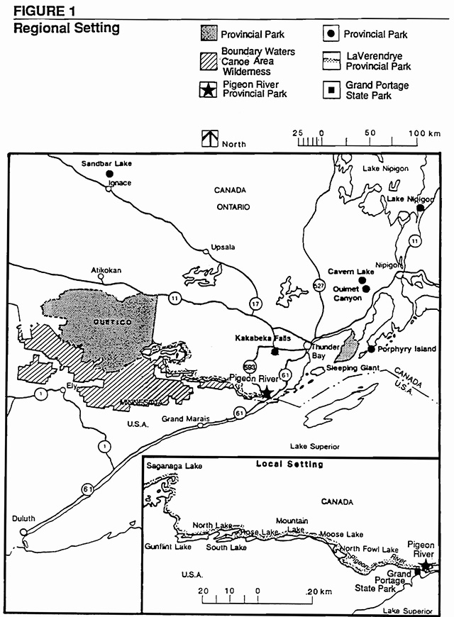
Enlarge figure 1 regional settings map
This document, the Park Management Plan, evolved from the public review of the Background Information and Alternative Concepts document and the Preliminary Management Plan. The approved Park Management Plan provides the rationale and guidelines by which the park will be managed over the plan’s 20 year lifespan. The Park Management Plan is reviewed regularly throughout this 20 year period and a mandatory review is held after 10 years.
2.0 Park classification
Pigeon River Provincial Park is classified as a Natural Environment Park. The Ontario Provincial Parks; Planning and Management Policies (1992 update) describes Natural Environment parks as incorporating "outstanding recreational landscapes with representative natural features and historical resources to provide high quality recreational and educational experiences."
Natural Environment status reflects the park’s diverse physiography, rich history and recreational attributes, as well as its geographical setting on the International Boundary where it abuts Grand Portage State Park in Minnesota.
3.0 Park goal
The goal for Pigeon River Provincial Park is "to protect an outstanding landscape that includes natural and cultural features of provincial significance and, in so doing, provide compatible recreational opportunities."
4.0 Park objectives
Attaining the above goal would ensure that Pigeon River Provincial Park contributes to the achievement of each of the four established objectives of the Provincial Parks System, which are as follows:
4.1 Protection objective
To protect provincially significant elements of the natural and cultural landscapes of Ontario.
Pigeon River Provincial Park contains a variety of natural and cultural resources that are provincially significant. These include:
- a diabase mesa/dike ridge system ("swarm") that some consider nationally significant
- events and processes associated with former glacial lakes which were restricted to this small corner of the province (i.e., the Pigeon River area)
- vegetation associated with diabase mesa tops and dike ridges
- the opportunity to protect clay substrates, which are relatively under-represented in the Provincial Park System
- the representation of prehistoric, historic and more recent features associated with aboriginal peoples, the fur trade, explorers and the timber industry
These resources will be protected through appropriate zoning and management policies.
4.2 Recreation objective
To provide day use, facilitybased camping and backcountry travel opportunities that are compatible with a provincially significant landscape.
Pigeon River Provincial Park provides outstanding opportunities for a variety of high quality, low-impact recreational uses compatible with the character of the park. These activities will allow users to experience a dramatic landscape that provides a chronology of geological events and processes spanning two billion years. The park’s variable terrain also provides excellent vantage points for observing dynamic, ongoing processes associated with the modern day Pigeon River and its juncture with the Lake Superior shoreline. Examples of activities which afford this experience include canoeing, kayaking, hiking, snowshoeing, cross-country skiing, viewing, snowmobiling and sail and power boating.
4.3 Heritage appreciation objective
To provide opportunities to observe and appreciate the natural and cultural heritage of the Pigeon River-Lake superior area through unstructured individual exploration and/or interpretation and education based on the character and significance of the park and its immediate area.
Interpretation programs will provide park visitors with an opportunity to appreciate and understand the area’s natural and cultural resources. This includes early exploration, the fur trade, the timber and mining industry, as well as the park’s earth and life science features. Section 9.1 Natural Heritage Education lists interpretive themes and portrayal techniques for the park.
4.4 Tourism objective
To provide Ontario residents and out-of-province visitors the opportunity to discover and experience the distinct natural and cultural attributes of this corner of the province in order to complement and strengthen the area’s tourist industry.
The natural and cultural features of Pigeon River Provincial Park will serve to attract tourists and area recreationalists. The park will achieve this through day use and camping opportunities. Winter use of the park through compatible activities, such as snowshoeing and cross-country skiing, will provide year-round tourism opportunities and, in doing so, strengthen the tourist industry. The park will also provide a first-hand opportunity to introduce outof-province visitors to not only the regional park system specifically, but the region’s tourist infrastructure in general. Given its border location the park serves as a "gateway to Ontario".
5.0 Park boundary
Most of the Pigeon River Provincial Park boundary coincides with natural features. Approximately 8 km of the Lake Superior shoreline makes up the park’s eastern boundary. The Ministry intends to extend the present shoreline boundary 200 metres out into Lake superior from the high water mark. Doing so would incorporate Morin Island and its adjacent small rock islet. Consideration will be given to including the Boundary Islands pending on-site studies. Existing boating and fishing activities would continue. The Canada-United States border, which runs along the middle of the Pigeon River, constitutes the southern boundary. Highways 593 and 61 define the park’s northwestern boundary. Acquisition of the 0.4 hectare parcel where the existing gift shop is located adjacent to the park’s northwest corner will be considered should this parcel become available.
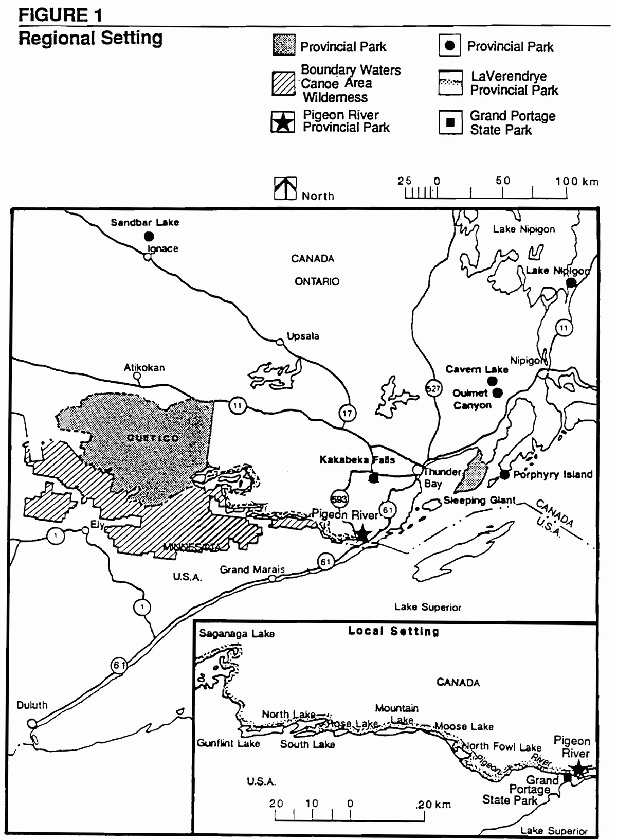
6.0 Park zoning
To provide specific management direction the park has been zoned based on designations described in the Ontario Provincial Parks: Planning and Management Policies (1978, updated 1992). Zoning allocates park areas on the basis of their significance for protection and their potential for recreation within the context of the park’s classification (Figure 2).
6.1 Natural environment zone
Natural environment zones include natural landscapes which permit the minimum level of development required to support low-intensity recreational activities. Development is limited (e.g., necessary signs, minimal interpretive facilities). Resource management policies are typically more permissive than those for wilderness and nature reserve zones. Natural environment zones often serve as buffers between development or access zones and the more protective wilderness, historical or nature reserve zones.
Figure 2: Park zoning map
Enlarge figure 2 park zoning map
6.1.1 NE1 (112 ha)
The purpose of this zone is:
- to provide opportunities for recreational activities such as hiking, picnicking, viewing, cross-country skiing and snowshoeing
- to provide a buffer between Highways 593 and 61 and the nature reserve zone to the south (NR1)
This zone is separated into two parts by Highway 61, however, for management purposes it is treated as one.
6.1.2 NE2 (16 ha)
The purpose of this zone is:
- to provide a relatively natural setting for part of the trail system that will be used to access High Falls
- to serve as a buffer between the Highway 61 border crossing infrastructure and the historic zone (H1) at High Falls and the nature reserve (NR1) protecting the dike ridge system to the north
6.1.3 NE3 (20.2 ha)
The purpose of this zone is:
- to permit motor boat access on the Pigeon River
- to permit fisheries management
This zone includes the Canadian portion of the waters of the Pigeon River. High Falls is located in this zone.
6.2 Nature reserve zone
Nature reserve zones protect significant earth and life science features which require management distinct from that in adjacent zones. They provide a high degree of protection and opportunities for regulated research. Such areas also provide quality opportunities for low-intensity, resource based activities such as hiking, viewing, photography and nature study. Protection is ensured through zoning and the designation of appropriate park uses and the enforcement of park regulations. Permitted development includes trails, necessary signs, minimal interpretive facilities and temporary facilities for research and management.
6.2.1 NR1 (690 ha)
The purpose of this zone is to protect a number of significant earth and life science features. These include:
- the diabase sill and dike ridge system and their associated talus slopes
- raised ridge and swale system denoting successional drops in ancestral lake levels
- mesa tops associated with ancestral lakes (e.g., Lake Washburn) that were restricted to this corner of the Lake Superior basin
- parkland vegetation associated with the mesa tops
- a number of forested deciduous and coniferous swamp communities as well as thicket swamp
- a number of regionally significant plant species
- a lacustrine plain consisting of fine-textured soil substrates presently under represented in the park system (e.g., clay)
This zone is separated into two parts by Highway 61, however, for management purposes it is treated as one.
6.3 Development zone
Development zones contain the area of the park geared towards the support of intensive day use and car camping activities. They constitute a relatively small portion of most parks. Development may include roads, visitor access structures, beaches, picnic areas, campgrounds, commercial service facilities, and orientation, interpretive, educational, research and management facilities. Two development zones have been designated in Pigeon River Provincial Park. Any new development will be subject to a favourable detailed site analysis. The purpose of this analysis is to determine whether use or development will have a detrimental impact on the park’s attributes or vice versa. Although use and development will have some degree of impact it should not impair the natural integrity of the resource base.
6.3.1 D1 (5 ha)
This is the existing campground and service area. The purpose of this zone is to provide:
- group camping/dayuse opportunities
- administrative facilities
- access to hiking trails
- viewing opportunities of Middle Falls
Due to site constraints car camping will be phased out and the area converted to a group camping/day use area. The area provides an opportunity to view Middle Falls located just a short distance upstream.
6.3.2 D2 (75 ha)
This area is located east of the border crossing facilities. The purpose of this zone is to provide:
- a new campground subject to favourable detailed site studies
- an administration, visitor control and service area
- parking and access to trial system
6.4 Access zone
Access zones serve as staging areas in which to direct and regulate use in areas of a park geared towards extensive recreation. Development is typically limited to roads and visitor control structures.
6.4.1 A1 (4 ha)
The purpose of this 8 metre wide zone is:
- to provide snowmobile access to the Canada-US Custom Stations
6.5 Historical zone
Historical zones encompass the provincially significant cultural resources of a park. They generally focus on a specific site (e.g., building) and its relationship to the surrounding landscape. Development is limited to trails, necessary signs, interpretive, educational, research and management facilities and historical reconstructions where appropriate.
6.5.1 H1 (5 ha)
The purpose of this zone is:
- to recognize and interpret the role of High Falls as a barrier to travel and commerce (e.g., logging, native and voyageur travel)
The design of viewing and interpretation facilities will be as unobtrusive as possible so as not to intrude on the view of the falls from the American side.
7.0 Canadian Heritage River System
Pigeon River and LaVerendrye Provincial Parks and the southern portion of Quetico Provincial Park have been nominated as the Boundary Waters-Voyageurs Waterway under the Canadian Heritage Rivers System. The Canadian Heritage Rivers System is a cooperative program developed and run by the parks' administrations of territorial, provincial and the federal governments to give national recognition to the important rivers of Canada. The primary objective of the program is to ensure that those rivers which are outstanding examples of Canada’s natural and cultural heritage, as well as offering outstanding recreational opportunities, are protected. The nomination of The Boundary Waters-Voyageurs Waterway was accepted by the Heritage Rivers Board in June 1986. It is expected to be officially designated as a Heritage River in 1996.
8.0 Resource stewardship policies
Resource stewardship will be guided by the Ontario Provincial Parks: Planning and Management Guidelines. Such stewardship policies will emphasize the overall goal and objectives of the park and concentrate on protection and heritage appreciation of the park’s natural and cultural resources while permitting recreation and tourism. Resource protection will vary depending on zone designation (Table 1).
A Park Operations Plan will be prepared in keeping with the direction provided in the Management Plan. The Operations Plan will provide specific operational guidelines for carrying out the management of the park’s resources.
Commercial removal of natural resources from the park is prohibited.
Status Indians having treaty rights to carry out traditional natural resource harvesting activities shall be permitted to carry on these activities in accordance with the terms of their treaty within their treaty areas.
8.1 Water management
Water management will maintain water quality for fisheries habitat and recreational purposes. Water quality will be monitored on a regular basis adjacent to development and access zones where camping occurs in accordance with Provincial health standards.
Park waters, located along the International Boundary, are under the jurisdiction of the International Joint Commission (IJC) of the United States and Canada. The Commission has jurisdiction over all matters involving the use, diversion, or obstruction of the boundary waters. The Ministry of Natural Resources will work in conjunction with the IJC and Canadian and American government agencies to ensure water quality along the International Boundary.
Table 1: Resource stewardship policies by zone category
Lands and waters
| Resource management policies | Park zone: D | Park zone: A | Park zone: NR | Park zone: H1 | Park zone: NE |
|---|---|---|---|---|---|
| Mineral exploration/extraction | x | x | x | x | x |
| Aggregate extraction | x | x | x | x | x |
| Commercial hydro development | x | x | x | x | x |
| Water control structures | x | x | x | x | x |
| Land disposition-camps, lodges | x | x | x | x | x |
Flora
| Resource management policies | Park zone: D | Park zone: A | Park zone: NR | Park zone: H1 | Park zone: NE |
|---|---|---|---|---|---|
| Vegetation management | Y | Y | Y* | Y | Y |
| Commercial logging | x | x | x | x | x |
| Insect/disease suppression - native | Y | Y | x | Y | Y |
| Insect/disease suppression - non-native | Y | Y | Y | Y | Y |
| Fire suppression-natural & man-caused | Y | Y | Y | Y | Y |
| Prescribed burning | x | x | M | x | x |
Fauna
| Resource management policies | Park zone: D | Park zone: A | Park zone: NR | Park zone: H1 | Park zone: NE |
|---|---|---|---|---|---|
| Commercial trapping | Status Indians Only | Status Indians Only | Status Indians Only | Status Indians Only | Status Indians Only |
| Wildlife population management | Y | Y | x | Y | Y |
| Bait fishing | x | x | x | x | x |
| Fish stocking: native species | x | x | x | x | Y |
| Fish stocking: non-native species | x | x | x | x | x |
| Fish habitat management | x | x | x | x | Y |
Recreation management
| Resource management policies | Park zone: D | Park zone: A | Park zone: NR | Park zone: H1 | Park zone: NE |
|---|---|---|---|---|---|
| Commercial tourist operations | x | x | x | x | x |
| Restrictions on all or specific vehicle types | Y | Y | Y | Y | Y |
| Can and bottle restrictions | x | x | M | x | x |
| Party size restrictions | x | x | x | x | x |
Legend
Y: compatible in zone category
x: not permitted
M: may be required
*: removal of hazard trees on trails only compatible in zone category
8.2 Vegetation management
Management of vegetation within the park will be conducted in a manner which will allow the natural succession of communities, recognizing that the control of insects, disease and fire may take precedence. With this objective in mind the activities described below will be undertaken.
Commercial forestry operations are prohibited within the park.
The removal of safety hazards such as "danger trees" will be permitted in all zones (e.g., on trails, campgrounds). Areas experiencing adverse use impacts will be rehabilitated using plant species native to the park whenever possible. Minor landscaping will be permitted in the access and development zones.
Vegetation may be removed for development of structures and facilities which are consistent with this Management Plan and any plans prepared in support of it. The biological features of a site will be inventoried before carrying out work to avoid negative impacts on significant sites or species. Trees which are removed may be used for park purposes such as firewood.
A vegetation stewardship plan will be prepared.
8.3 Fire management
All fires will be suppressed. Prescribed burning may be used to replace natural processes under the proper circumstances. Fire suppression techniques will be used which have as minimal effect as possible on the park environment. Bulldozing and water bombing with chemical additives will not be permitted, except in critical situations as determined by the Park Superintendent.
8.4 Wildlife management
Wildlife management will be compatible with the management of areas adjacent to the park, and with policies and regulations.
Hunting is not allowed.
Fur trapping by non-natives will be phased out by the year 2010.
Nuisance animals will be controlled under the strict supervision of, or directly by, the MNR. such control will be exercised when it is essential for the protection of human health and safety, park values, or the health of animal species. The techniques used, such as trapping, relocation, or shooting as a last resort, will have minimal detrimental effects on other components of the park environment.
8.5 Fisheries management
Fisheries management will be done in accordance with the "Thunder Bay District Fisheries Management Plan (DFMP)" (OMNR, 1989). The DFMP identifies the need for a specific Fisheries Stewardship Plan for the area of Pigeon River Provincial Park.
Sport fishing is permitted in the park. All fishing activity will adhere to the policies and regulations of Division 21 of the Ontario Fishing Regulations. The Park Superintendent may restrict sport fishing at certain times and locations for the purposes of fisheries management and/or public safety.
Stocking and spawn collection by permit are allowed.
The use of live bait for the purpose of fishing is permitted.
Commercial fishing and commercial bait fishing are not permitted.
8.6 Landform management
The management of the park’s land base will be directed towards maintaining the natural landscape. Mineral exploration and mining are prohibited.
Erosion control work to protect park values and public safety is permitted in the access and development zones. The use of non-structural techniques will be emphasized.
The establishment of roads and utilities for park purposes will be directed by approved site plans. Such projects will be permitted in the access and development zones only and their progress will be closely monitored.
Waste disposal sites and dumping are prohibited within the park. Garbage collection facilities will be located in the access and development zones only. Solid waste and sewage generated by park users will be disposed outside the park through local facilities or in an established area.
Road, rail and utility line corridors through the park are prohibited. Commercial billboards will not be allowed in the park.
There will be no removal of mineral aggregate from the park. Aggregate for purposes will be imported sources outside the park.
A landform stewardship plan will be prepared.
8.7 Cultural resources management
The management of cultural resources will be directed to protection, heritage appreciation and research. Protection of archaeological and historic sites will be achieved through zoning and by limiting the type and amounts of recreational activities and development that occur in these areas.
The Ministry of Natural Resources will continue to work in conjunction with Ministry of Culture, Tourism and Recreation in the inventory, protection and maintenance of archaeological and historic sites. If deemed appropriate and necessary for the protection and preservation of cultural resources, such inventory may include excavations of archaeological sites. Excavations by authorized licensed personnel with appropriate research permits will be conducted under the approval and supervision of the above Ministries. Upon completion of excavation, the site or portions of the site will be returned to their original condition, or will be developed for the purposes of interpreting the cultural resources inherent in the sites. The type and extent of such development will be determined by the findings from the excavation.
Periodic inspection of significant sites will occur with protective controls established as required. The removal of artifacts or destruction of historical features is illegal.
This plan designates an area (D2) in the vicinity of the Pigeon River mouth for a future campground and associated services. An archaeological survey will be part of the site assessment. Significant archaeological discoveries may necessitate alterations to the campground design or even prevent its establishment.
9.0 Operational policies
Park operations will be managed in accordance with the Park Management Plan. The Operating Plan will provide park staff with the necessary information required to operate the park on a day-to-day basis. In addition to addressing the operations policies which follow, the Operating Plan will include such topics as budget, staffing, maintenance schedules, enforcement and emergency services. The provisions of the Operating Plan will be consistent with the approved Ontario Provincial Parks Operating Standards and will be reviewed annually and updated as required.
The MNR will encourage through partnerships with the private sector or volunteers, the provision of park services. All private sector services considered will be consistent with the policies of this plan.
A Sign Plan will be prepared which will outline a strategy for sign development, and placement of directional and informational signs.
9.1 Natural Heritage Education
Pigeon River Provincial Park will offer a self-serve level natural heritage education program. The primary objective will be to orient park visitors to the park’s natural and recreational attributes. Given its integral relationship with an international border crossing the park will also serve to introduce out-ofcountry visitors to the provincial park system of northwestern Ontario. To achieve this the park will endeavour to work with the Pigeon River Tourist Information Centre.
A Natural Heritage Education Plan will be prepared. It will provide details regarding the natural heritage education program and facilities for the park. The program will emphasize use by local residents, destination campers and cross-border visitors. It will be oriented to park visitors of all ages and a variety of interests. Self-use approaches such as publications and display panels will be used to deliver park information, resource interpretation, recreational skills and park management messages.
9.1.1 Park information
A public information program will be established which will provide visitors with information about the park and its resources, environment and facilities. This information will emphasize the visitor’s role in maintaining the park’s natural environment, appropriate behaviour in parks, safety in the outdoors and nuisance animals. Park literature will also advise visitors of commercial services and attractions in the local area and other provincial parks.
A map and information package will be produced to enable users to safely explore and use the park. A leave no trace attitude will be promoted in order to minimize human impact on the park environment. The importance of respecting other users will be stressed.
9.1.2 Interpretation
Interpretive programs and facilities will provide park visitors with a greater appreciation for and understanding of the natural and cultural features of Pigeon River Provincial Park. Printed material, self-use facilities and informal personal contact will be the primary means of interpretation. The park’s main interpretive theme relates to its geological significance (Geology and Landscape) and how this geology has affected cultural activities (e.g., the avoidance of this section of the Pigeon River by fur traders; the timber industry having to divert logs around High Falls). Other themes include Pre-European settlement, Early European Exploration, Logging Era, Vegetation, Wildlife Viewing and International Relations. Innovative ways of cooperative portrayal of these themes will be pursued with other agencies.
9.1.3 Recreation
Basic recreation information provided on the park map will acquaint visitors with the park’s attributes, its dangers (e.g., vertical cliffs) and the skills required to safely interact with it.
9.2 Recreation management
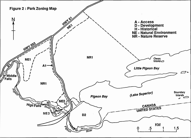
Recreation management will optimize recreational opportunities but, in doing so, minimize environmental impacts in recognition of the park’s significant landscape. Opportunities will be provided for users to experience the park environment through a number of activities such as hiking, canoeing, kayaking, cross-country skiing, snowmobiling and snowshoeing. Associated activities include camping, fishing, picnicking, swimming and scenery and wildlife viewing. To facilitate some of these activities a low density trail system will be developed that is compatible with the park’s goal and objectives. This system will allow users to come in close contact with the Pigeon River and Lake Superior shorelines as well as providing long distance views or vistas of the regional terrain (e.g., Isle Royale) from high vantage points. Figure 3 is an example of how the trail system might appear. The ultimate layout will depend on detailed site analysis.
Recreational activities incompatible with the park goal or zones are prohibited or restricted. Prevention of such activities will be through public education of park visitors concerning appropriate uses in parks in general and the individual zone designations specifically (see Table 2).
Car camping will be moved from the existing campground area (D1) to the area near the river mouth (D2). This move, however, will be dependent on the outcome of a detailed site analysis of this area.
Motorboats are a permitted use up the Pigeon River to the extent that water depths permit. Boat caches are prohibited within the park.
Should an official trail be established snowmobiles will be restricted to a narrow corridor zone (A1) adjacent to Highways 61 and 593. This route would allow cross-border snowmobilers access to Canadian and American customs.
Motorized all-terrain vehicles and off-road dirt bikes are prohibited. Motorized all-terrain vehicles will be allowed for Ministry staff to service the park should their use be deemed necessary by the Park Superintendent.
The possession of cans and bottles in all areas of the park is permitted. Restrictions may be imposed should garbage problems occur in the nature reserve zone. Disposal will be only at designated locations in the development zones.
Recreational structures are prohibited in the nature reserve zone.
Monitoring of recreational activities will occur in order to maintain the park’s natural character. New or revised restrictions on certain activities may be established, if necessary, to maintain the quality of the park’s natural and cultural resources but also the level of user experience.
9.3 Tourism services
Although the park’s resources (e.g., High Falls) offer excellent potential to attract tourists, the level of services will be dependent on the environment’s ability to sustain such activity. Development will be compatible with the park’s physical setting and will not occur where similar facilities and services are available nearby. The upgrading of existing park facilities, as well as the instigation of the projected development in zone D2, will occur as funding permits.
Table 2: Permitted recreational uses by park zone
| Recreational uses permitted | Park zone: NE1 | Park zone: NE2 | Park zone: NE3 | Park zone: NR1 | Park zone: D1 | Park zone: D2 | Park zone: A1 | Park zone: H1 |
|---|---|---|---|---|---|---|---|---|
| Boating (power) | x | x | Y | x | x | x | x | x |
| Campground-car | x | x | x | x | x | Y | x | x |
| Campground-group | x | x | x | x | Y | x | x | x |
| Canoeing-kayaking | x | x | Y | x | x | x | x | x |
| Hiking | Y | Y | x | Y | Y | Y | Y | Y |
| Mountain biking | x | x | x | x | Y | Y | Y | x |
| Nature appreciation | Y | Y | Y | Y | Y | Y | Y | Y |
| Orienteering | Y | Y | x | Y | Y | Y | Y | Y |
| Concession | x | x | x | x | x | M | x | x |
| Painting/photography | Y | Y | Y | Y | Y | Y | Y | Y |
| Picnic grounds | x | x | x | x | Y | Y | x | x |
| Playgrounds | x | x | x | x | Y | Y | x | x |
| Recreation programs | x | x | x | x | Y | Y | x | x |
| Sailboarding | x | x | Y | x | x | x | x | x |
| Sailing | x | x | Y | x | x | x | x | x |
| Skiing: x-country | Y | Y | x | Y | Y | Y | Y | Y |
| Snowmobiling: on designated trail | x | x | Y* | x | Y | Y | Y | x |
| Snowshoeing | Y | Y | Y | Y | Y | Y | Y | Y |
| Sport Fishing | x | x | Y | x | x | x | x | x |
| Swimming | x | x | Y | x | x | x | x | x |
Legend
Y: permitted use in designated zone
x: not permitted
M: may be permitted in designated zone
Note: activities not in this list are prohibited within the park
*: designated trail only
The development of commercial facilities will take place only in projected development zone D2 and, failing this, in zone Dl. The Park Operating Plan will detail the location, type and extent of such development. It will also provide specifications and guidelines for the tendering of detailed proposals.
9.4 Marketing
A marketing plan will be developed for Pigeon River Provincial Park in accordance with established Ministry policy and procedures. It will be reviewed annually and revised as required. Marketing activities will be consistent with the Regional Marketing Plan.
The objectives of the marketing plan are:
- to capitalize on the park’s natural and cultural features in order to provide visitors with a unique outdoor experience within the park goal and objectives
- to encourage park visitation and the use of the park as a catalyst to stimulate the local and regional economy
- to encourage park use and visitation to low use areas of the park but in keeping with the park goal and objectives
- to work cooperatively with commercial establishments marketing the park and their services
- to encourage year-round use of the park
9.5 Research
Scientific research by qualified individuals which contributes to the knowledge, inventory and identification of natural and cultural features and to environmental and recreational management objectives will be encouraged. Subjects of particular interest include archaeology and geomorphology (e.g., raised shorelines) as well as life science studies (e.g., plant communities and species).
User surveys will be undertaken to determine patterns and extent of park use in order to develop strategies to better distribute use throughout the park.
All research programs must be compatible with the park’s goal, objectives and zoning prescriptions. Such programs require prior approval and must be conducted in accordance with MNR policy concerning research in provincial parks. Research must also meet al. other applicable Provincial and Federal Government requirements. such programs will be monitored by Regional Parks. Any archaeological research will also require approval and monitoring by the Ministry of Culture, Tourism and Recreation. Should provincially or nationally significant features/resources be found, the Management Plan may be amended to ensure that protection will be provided through appropriate zoning or revision of Plan policies.
10.0 Development policies
Development will be implemented through work program planning based on priority and subject to the availability of funds. Development will be carried out in accordance with approved site and development plans which detail the location, type and extent of development permitted.
Where necessary during the planning stage of development within the park, MNR will work in conjunction with the Ministry of Culture, Tourism and Recreation to conduct archaeological site assessments in the area of the proposed development. Should sites be known or discovered to exist in that area, opportunities for inventory of the site(s) will be provided. The maintenance and protection of such sites will be directed by research findings. Modifications to the planned development may be considered dependent upon the significance of the archaeological site.
Additional roads and utilities will be permitted in development zones only and construction will be closely monitored by MNR. The upgrading, construction and maintenance of park roads in the development zones will be conducted on a continuing basis as required to implement the Management Plan.
No development will take place in the nature reserve zone (NR1), except for necessary signs and trails.
Interpretive, informational and directional signs will be installed at appropriate locations in accordance with the park’s Sign Plan.
10.1 D1
Pending the outcome of a detailed site analysis it is intended that the existing car campground in this zone be moved to development zone D2 (Figure 3). Zone Dl will become a group camping/day use area. The present staff quarters building in this area will continue to serve the same function. If commercial facilities are not possible at D2 they may be permitted in D1.
10.2 D2
Pending detailed site analysis it is intended that zone D2 serve as the park’s administrative and operational headquarters as well as provide areas for day use activities (e.g., swimming) and a car campground to replace the existing one in zone D1. Facilities associated with this purpose include park office and administration buildings, garbage collection facilities, visitor and entry control structures and interpretive and informational displays. Development along the river’s edge will be as unobtrusive as possible in order to be compatible with the land base on the American side.
This zone also provides the opportunity for the development of limited commercial facilities by the private sector (e.g., an outlet for the sale of camping supplies) should such supplies not be available nearby.
10.3 A1
When and if an official snowmobile trail is established access zone Al will serve as a corridor to funnel cross-border snowmobilers through the park. The vegetation on this planned corridor will not be removed, however, until this trail is officially established.

Enlarge figure 3 proposed development map
11.0 Plan implementation and review
The management plan will be implemented through work program planning and is subject to the availability of funding. All development, operations and activities undertaken within the park will comply with the Environmental Assessment Act.
11.1 Implementation priorities
The implementation of park developments and improvements will be in accordance with the phases as described in order of priority in Table 3. Day use facilities will be the highest priority (e.g., trail to High Falls). Each phase deals with the preparation and implementation of various plans and site and development concepts. The phases are not intended to be mutually exclusive. Work described in a subsequent phase may begin before work in a preceding phase is completed. Preferably, it would not be started until work in the preceding phase is well underway.
Special sources for funding the development of facilities will be investigated and utilized as fully as possible.
Recreation management regulations will become effective upon approval of this plan and the establishment of necessary regulations under the Provincial Parks Act.
11.2 Plan review and amendment
The Pigeon River Provincial Park Management Plan will be reviewed throughout its 20 year lifespan where warranted to address issues or changing conditions. A mandatory review is scheduled to occur after 10 years. The review will be conducted in the following manner:
- review of background information and data about the park resources and use
- review the status of implementation of the approved Management Plan and provincial policies
- identify MNR, other agencies and public issues of concern
- prepare and present issues and suggested solutions for public review and comment
- review proposed revisions recommended by the public
- prepare and receive approval for plan amendment
A variety of ongoing monitoring programs will provide essential information concerning the implementation of the Management Plan and the effectiveness of approved policies. Such mechanisms as the collection of user statistics, periodic user surveys and park management audits will provide valuable information and feedback to ensure that policies remain current and relevant. Research findings and resource inventory work may aid in conducting plan reviews.
Table 3: Implementation Priorities
| Phases | Resource stewardship plans | Developments |
|---|---|---|
| Phase 1 | Site Plan for trails Archaeological Study Site Plan for D2 | Construct trails |
| Phase 2 | Natural Heritage Education strategy Marketing Strategy | Reconstruct portion of sluiceway |
| Phase 3 | Operations Strategy Sign Plan | Development of D2: day use, campground, services and administration |
| Other | Fisheries Stewardship Plan Vegetation Stewardship Plan Landform Stewardship Plan Other resource studies (e.g., field studies of Boundary Islands, raised shorelines, etc.,) | Possible incorporation of Morin Island and adjacent islet, and Lake Superior shoreline buffer and Boundary Islands |
12.0 Summary consultation of public
Public consultation for the Park Management Plan started with the preparation and distribution of the "Background Information and Alternative Concepts" document to interested and affected individuals and organizations. Approximately 75 copies were distributed in March, 1994. Open houses were held in Thunder Bay on March 21, 1994 and the Municipality of Neebing on March 22 to give the public an opportunity to comment on the Background Information and Alternative Concept document. A total of 21 persons attended these open houses. Newspaper advertisements were used to solicit public comments, construct a mailing list and announce open houses.
In addition, meetings were held with federal, provincial and municipal representatives and with Grand Portage State Park officials. Input from the above process was used to formulate the Preliminary Management Plan which was then distributed in August, 1994 to those people on the mailing list. An ongoing open house display was set up for the summer months at the park office to solicit comments. The Park Management Plan evolved from comments resulting from the park open house and from the public review of the Preliminary Management Plan. Table X below outlines the issues that arose over the course of this planning process and their subsequent resolution.
Table 4: Issues and resolutions
| Issue | Response/resolution/rationale |
|---|---|
| Park name | The name was changed to Pigeon River to reflect the river’s heritage. Also, Middle Falls is not in the park. |
| Incorporate park into LaVerendrye | Most respondents thought the park should remain a separate entity. |
| Hunting in park | Prohibited; majority felt hunting was a non-compatible use; safety concern |
| Snowmobiling | Public felt this was an incompatible use, however, a narrow corridor has been provided to allow snowmobilers access to Canada/US custom stations. |
| Hiking trail system | Most respondents felt the trail system should be improved, especially the trail to High Falls. |
| High Falls area | Public wanted the viewing facilities improved and part of the sluiceway rebuilt as an historic feature. |
| Relocate campground to Lake Superior | Opposition expressed about proposed campground, however, new site offers a beach and swimming. Existing campground is constrained by seasonal wetness. |
| Level of development | Development should complement the significance of the park’s natural landscape and be unobtrusive from the us side. |
References
Banks, B. 1989. Satellite Images: Photographs of Canada From Space. Camden House Publishing, Camden East, Ontario. 120p.
Bardecki, M. and Boles, B. 1972. The Geomorphology, Vegetation and Floristics of Middle Falls Provincial Park. Ontario Ministry of Natural Resources, Parks Inventory Series, unpublished report.
Bird, S.J.G. and Hale, I.M. 1982. Air Photo Interpretation of the Physical Environment. Bird and Hale Ltd., Toronto, Ontario.
Hewitt, D.F. and Freeman, E.B. 1972. Rocks and Minerals of Ontario. Dept. of Mines and Northern Affairs, GC13. 145p.
Mollard, J.D. and Janes, J.R. 1984. Air Photo Interpretation and the Canadian Landscape. Department of Energy, Mines and Resources. Ottawa. 415p.
Ontario Ministry of Natural Resources. 1983. Thunder Bay District Land Use Guidelines. Thunder Bay District, Thunder Bay, Ontario.
Pye, E.G. 1969. Geology and Scenery, North Shore of Lake Superior. Ontario Department of Mines. Geological Guide Book No. 2.
Theberge, J.B. (ed.). 1989. Legacy: The Natural History of Ontario. McClelland & Stewart Inc., Toronto, Ontario. 397p.