Point Farms Provincial Park Management Plan
This document provides policy direction for the protection, development and management of Point Farms Provincial Park and its resources.
Note: This document has been scanned and formatted, and therefore is slightly different form the original version. -March 2002
Office of the Minister
Ministry of Natural Resources
416 965-1301
Whitney Block
Queen’s Park
Toronto Ontario
Minister’s approval statement
Since the establishment of Point Farms Provincial Park in 1964, it has played an increasingly important role in meeting the need for recreational experiences in Southwestern Ontario. Changing circumstances associated with user patterns and concern for the park environment required a reevaluation of the park’s plan, operation and management. Therefore in accordance with Sections 1d and 7a of The Provincial Parks Act, I am pleased to endorse this master plan as the official policy for the preservation, development and management of Point Farms Provincial Park.
I take this opportunity to express appreciation to the councils of the Town of Goderich and the Township of Colborne and interested groups and individuals in the vicinity of the park for their valuable comments during the master planning process.
Through the implementation of the plan, I am confident that the resources of the park will be protected and enhanced and that the area will provide a wide variety of recreational opportunities.
Hon. Frank S. Miller
Minister
November, 1977
| Metric Measures | Unit Equivalent |
|---|---|
| centimetre (cm) | 0.3937 inches |
| metre (m) | 3.2808 feet |
| kilometre (km) | 0.6214 miles |
| square kilometre (sq km) | 0.3861 square miles; 100 ha |
| hectare (ha) | 2.4710 acres |
| cubic metre (cu m) | 35.3148 cubic feet |
| litre (1) | 0.2200 gallons |
| kilogram (kg) | 2.2046 pounds |
| kilowatt (kw) | 1.3410 horsepower |
| degrees celsius (°C) | °C x 9/5 + 32=degrees Fahrenheit (°F) |
Master plan highlights
The park will be designated as a recreation park under the Ontario Provincial Parks Classification System.
The park will be operated from mid-May to mid-September. Visitors wishing to use the park on a daily basis during the winter may do so, free of charge, although no running water, electricity, or other park services will be available.
Locally significant historical sites, fragile vegetation communities and physically sensitive areas will be protected from intensive development and environmental damage whenever possible.
The park will be developed as an intensive recreation area centered around camping and day-use opportunities.
The park will consist of a development zone within which provision will be made for recognition and management of an historical area and a fragile area. Resource management practices, consistent with this zone and compatible to these sensitive areas will be carried out.
Limited access to the beach will be provided by a series of wooden steps down the bluff slope and one access road. Parking on the beach will be eliminated when pressure on this small beach area makes this measure necessary.
An intensive visitor services program will be developed according to the guidelines outlined in this master plan.
The Stirling Barn will be renovated to incorporate a visitor centre and will serve as the activity site for all interpretive and recreational programs.
Resource management programs will be undertaken to preserve fragile environmental areas and to enhance the aesthetic appeal of the park landbase.
Park development will occur in two phases. Environmental impact and visitor use will be monitored.
The rural atmosphere of the park will be maintained and fostered through the design of facilities and the operation of the visitor services program.
Controlled snowmobiling and hunting will be permitted within the park.
Introduction
Point Farms Provincial Park is located in one of Ontario’s recreational belts, the Bluewater shoreline of Lake Huron. Utilizing the two settings, the Lake Huron shoreline and the adjoining agricultural land, this park combines local history with interesting biophysical features to provide a varied yet intensive recreation site. The Point Farms area has been a focus for family relaxation since the mid-1800s, when an early summer resort in southwestern Ontario, the Point Farm Hotel, existed on what is now park property. This hotel drew visitors from all parts of Southern Ontario and the northern United States until it ceased operating in 1915.
Most of the present Point Farms land base was acquired between November 1963 and January 1964 by the then Ontario Department of Lands and Forests, in recognition of the need to provide increased access to water bodies and beach areas on the Great Lakes shorelines. The remainder of the land was purchased in 1966.
Work commenced on the development of park facilities in the spring of 1964, when the first campsites were laid out to form the Colborne Campground. A tree planting program was carried out in the area presently known as the Huron Campground during the following two years. The park officially opened in 1965, and visitors journeyed to this provincial park for their first taste of camping at Point Farms. At this time, the roads were gravel but were paved four years later.
Since 1965, many changes have occurred in the overall design of park facilities, the level of programming offered to visitors, the methods of operating and managing parks and the approach to park planning. Consequently, by 1974, it was recognized that a comprehensive evaluation of Point Farms would result in an improved service to the public. Thus, a master planning exercise was initiated, stimulated by the desire to upgrade facilities and redesign the park according to its environmental capabilities.
Following the completion of initial resource inventories and market area analyses, a draft master plan was written. This plan was reviewed within the Ministry of Natural Resources and presented to Goderich Town Council and Colborne Township Council for comments. The details of the public participation program are outlined in Appendix A.
The master plan was then rewritten with these comments and recreations in mind. In accordance with established Ministry policy, this plan will be reviewed and updated at regular five-year intervals and will be completed as funds and priorities permit.
Purpose of a master plan
A provincial park master plan is a document which establishes policy guidelines for the long-term development and management of a park. Within this context, the purposes of the master plan are:
- To define the role and significance of a particular park in relation to the total provincial park system.
- To examine and ascertain the existing supply of recreational opportunities, type and extent of facilities offered, transportation linkages, and population projections influencing the characteristics of the park site.
- To analyze and establish resource values and environmental limitations of the park property.
- To designate the appropriate classification and zoning system for the park.
- To define the goal and objectives that will establish the individual character Of the park.
- To outline concept plan alternatives and recommend the plan to be pursued.
- To define visitor services program guidelines.
- To establish management and site planning guidelines for the park.
Regional context
Unquestionably, the geographic features of a region influence the planning for the future of any recreation area within that region. Thus, consideration of the following material was essential preparatory to the formulation of plan variations for Point Farms Provincial Park.
Regional setting
Point Farms Provincial Park is an intensive, outdoor recreation area situated on the eastern shore of Lake Huron within the northeast sector of Colborne Township, Huron County. As shown in Figure 1, it is located within a day-trip distance of the major population centres and transportation routes of southwestern Ontario.
Huron County is predominantly an agrarian community which specializes in raising livestock. Like most of Southern Ontario, it has been experiencing a general population shift from rural to urban areas; nevertheless, urban pressures are still minimal and the growth rate is quite slow. The lack of manufacturing has resulted in the migration of young people to industrial centres outside the county.
In addition to its agricultural resource, Huron County contains the Lake Huron shoreline, a unique and valuable resource which acts as a recreation activity focus, attracting visitors from the major development corridor consisting of the urban centres of Windsor, Chatham, London, Kitchener-Waterloo, Guelph, Galt, Hamilton and Toronto. The 72 km of county shoreline, extending from just south of Grand Bend to Amberley Beach at the northern boundary, is an area of simple physical uniformity. It consists of a sand and cobble dry beach averaging only 18 m in width, which gives way to clay bluffs averaging 20 m in height. On top of the bluff, the land is mainly agricultural, and hence there is only limited tree cover.
Unfortunately, the recreational trend along this shoreline has been to develop linear seasonal residential dwellings. In addition, in situations where private water lot rights have been granted, the public is not permitted to use the beach. Colborne Township, with nearly 11 km of shoreline, has slightly more public lake frontage than the other shoreline townships because the park incorporates 155 in of lake frontage. There are no private cottages within the park.
Within Huron County, other sites of public access to the Lake Huron shoreline include five harbours and marinas in Bayfield and Goderich, ten access points, of which only four provide free entry to the beach and seven small public town beaches. There are also 16 private campgrounds and children’s camps. In general, the provision of public open space has not kept pace with the ever-increasing cottage development throughout Huron County as well as along the shoreline (Huron County Shoreline Study, 1974).
Figure 1: Regional Context
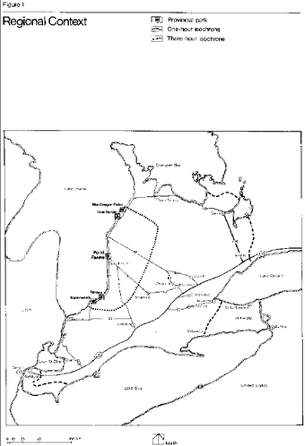
Enlarge Figure 1: Regional Context
The tourist region of the Bruce Peninsula is situated north of this area. Consequently, Point Farms Provincial Park is a natural stop-over point for tourists travelling from urban Southern Ontario and the bordering United States to the vacation areas of the Bruce Peninsula and the Georgian Bay shoreline. These transient highway travellers as well as local residents influence the day-use pressures felt in this park.
Population centres
The closest urban centre to Point Farms is Goderich, a town of 7,044 people in 1975. It lies 6.4 km south of the park in a popular vacation district with beach resources which appeal both to residents and tourists. In addition to shopping facilities, the town includes two historical sites, the Huron County Museum and the Goderich Airport which was the site of a Commonwealth Flight Training Centre during World War II. Two golf courses are located just south of the park off Highway 21.
Access
Point Farms Provincial Park can be easily reached by potential users from urban southwestern Ontario by major arterial highways. Direct access to the park from the local market area, consisting of all the Lake Huron shoreline communities, is provided by Highway 21. A direct route from the park’s regional market area is provided by Highway 4 and Highway 8. These routes are not congested even at the peak of summer traffic (McNab, 1974). No major traffic alterations are planned within Huron County in the near future, although upgrading will be done to improve some local roads. The present road access system is satisfactory according to the level of development planned for Point Farms.
Few, if any, visitors have travelled to Point Farms by any method other than private cars. This arrangement is expected to continue, since no local bus service to the park or passenger rail service in Goderich is available. One bus passes the park entrance Monday to Saturday en route from London to Owen Sound, but it is extremely unlikely that this will be used as a method of reaching the park. A local airfield situated approximately 3.2 km south of the park is used mainly by two-seater to six-seater sport planes, although it can accommodate small jets. literature pertaining to the camping and day-use facilities provided at Point Farms may be made available at this airfield. There are other airfields serving private planes at Centralia, Kincardine, Port Elgin, Stratford, Wiarton and Wingham. However, as it is anticipated that travellers using these airfields will generate only an extremely minor part of the park’s clientele, literature on Point Farms will not be on display.
A marina for pleasure crafts exists at Goderich. There are plans for the expansion of this facility in the future. However, boating is not expected to provide a significant portion of the clientele and docking facilities will not be constructed to provide water access to the park property.
Market analysis
Market areas
Local and regional market areas were defined for the purposes of summarizing a recreational opportunities demand and supply framework relative to the Point Farms facilities. This information was referenced when predictions were being made as to the level of service Point Farms Provincial Park should supply in the future.
The local market area is defined as the area inside Point Farms’ one-hour isochrone.
The regional market area is bounded by the three-hour isochrone. This boundary represents the maximum travel time distance beyond which people would be unwilling to travel to this park to camp (Figure 1).
The local market area, encompassing all of Huron County and small sections of Bruce, Middlesex, Perth and Lambton counties, contains a population of 128,500. By 1981 and 1986, this population is expected to increase to 134,000 and 141,000, respectively.
The total population within the regional market area, which includes such major centres as Toronto, Hamilton, Guelph, Kitchener- Waterloo, London and Windsor, was over 5 million in 1974. Based on the most recent population projections, (TEIGA, 1975), this number will have increased to 5,717,500 by 1981, 6,598,800 by 1991 and by 2001, the population will be 7,315,700.
The majority of campers at Point Farms originate from the area demarcated by the three-hour isochrone, according to camper origin surveys conducted from 1968 to 1970. In 1968, approximately 77 percent of the total number of campers staying at Point Farms originated from places lying within the regional market area. Sample surveys taken in the other two years found that 72 percent of the campers in 1969 and 76 percent in 1970 came from within a three-hour’s drive of the park.
Alternative recreational opportunities within the market areas
Local market area
This section outlines the alternative recreational opportunities within Huron County. There are 27 private campgrounds within the county operating a total of 2,535 developed sites. Over 70 percent of these campsites are serviced with electricity.
Although there are many Conservation Authority sites within the local day-use market area, only those of the Maitland Conservation Authority have been considered in detail because they have the most immediate effect on the demand for day-use facilities at Point Farms.
Of the eight areas administered by the Maitland Conservation Authority, only Falls Reserve, near Goderich, provides camping facilities. Seventy-five campsites currently exist within the 91.6 ha conservation area, although it is proposed to develop an additional sixty-five sites in the future. Other minor campsite facilities exist within the Galbraith Conservation Area and the Wawanosh Township Park now operated by the Conservation Authority. In addition, the Maitland Conservation Authority provides approximately 160 day-use picnic table sites within the areas it administers. In addition to the Conservation Authority’s provision of day-use facilities, there are nineteen picnic areas situated within the towns of Goderich, Bayfield, Blyth, Brussels, Clinton, Exeter, Hensall and Seaforth and the three townships of Ashfield, Stanley and Turnberry. Several private campgrounds within the local market area also provide picnic facilities.
Provincially-operated recreational facilities are very limited within the local area. Apart from Point Farms Provincial Park, the only other major area administered by the Ministry of Natural Resources is the Hullett Wildlife Management Area located 6.4 km northeast of Clinton. The master plan for this 2,000-ha wildlife area indicates that the recreational facilities will complement the opportunities currently available elsewhere in the surrounding area; for example, no camping will be allowed within the area. Instead, the management area will be a nearby day-use attraction for campers staying at Point Farms.
The other major influence on recreational patterns in the local market area is the limited lake access available to the public along certain sections of the Lake Huron shoreline. To illustrate the problem, of the 72.4-km of Lake Huron Shoreline within Huron County, 53 percent is occupied by cottage development.
Regional market area
Comments will be restricted here to the consideration of recreational opportunities as provided through provincial park facilities existing immediately adjacent to Point Farms Provincial Park. Such provincial parks are oriented to Lake Huron and are sometimes the pre-destination or post-destination stopover points for some Point Farms campers.
Three provincial Parks, Point Farms, Ipperwash, and MacGregor Point, are classified as recreation parks, while Pinery Provincial Park and Inverhuron Provincial Park are natural environment parks. The recreation parks include a total of 1,437 ha, while the natural environment areas consist of 2,381 ha. In general, based upon the number of vehicle entries, visitors, campers and camper-days in these parks, Point Farms consistently has the lowest user statistics which would appear to indicate visitor preferences for camping and day-use at Ipperwash, Pinery and Inverhuron (Ontario Provincial Parks Statistical Reports 1972 to 1974).
Park user trends at point farms
From 1970 to 1974, approximately 30 percent of the park users were day-visitors and 70 percent were campers. The day-use pattern at Point Farms can be deduced from the records of day-use permits issued and visitor surveys conducted in previous years. Over 14,000 day-users came to the park in 1970, and in the following year, there were over 15,000 visitors. Primarily as a result of cool, wet weather, during the 1972 summer season, the number of day-users dropped by 23 percent, but increased in 1973 to over 13,000 and to 16,400 in 1974.
From a total of 3,660 parties surveyed, approximately 2,280 or 62 percent of the day-use visitors originated from within a one-hour drive of the park in 1971 (Ministry of Natural Resources, Day-use Survey, 1971). However, the survey indicated that parties from Metropolitan Toronto, Kitchener-Waterloo and Hamilton are not uncommon, and it also identified 180 parties from Michigan. However, the survey did not indicate how many of the day-use visitors were cottagers staying within the immediate area.
The campsite occupancy rate has varied widely in past years. In 1971, the rate was 40 percent of the total capacity. It dropped to 26 percent in 1973 and rose again to over 40 percent in the following summer camping season. As is the case in the majority of parks, the busiest camping months at Point Farms are July and August. The campsite occupancy rate for these months was 53 percent in 1973 and 69 percent in 1974. For both years, the park had a total of between 200 and 208 developed campsites (Table 1).
A distinctive user pattern has evolved within the park. The heaviest day-use occurs on Sundays with day-use visitors consisting mainly of young families who come to the park to picnic and swim. Adverse weather conditions can greatly curtail this type of visitation on any given day.
Campers staying at Point Farms are characteristically young families. In July and August, the campgrounds are almost full to capacity each weekend. In fact, many family campers are refused admission and turned away on holiday weekends because the campgrounds are full. The early part of the operating season is characterized by the presence of senior citizens camping within the park. In addition, approximately 25 groups, varying in size from five to 50 campers, utilize Point Farms’ group camping area each year.
Table 1: Visitor Statistics for Point Farms Provincial Park
Annual Totals
| Year (opening and closing date) | Campsites in use (total for season) | Camping permits issued | Daily permits issued | Number of camp days used | Total number of vehicles entering park | Total number of visitors | Number of campers | Group camping group | Group camping campers |
|---|---|---|---|---|---|---|---|---|---|
| 1970 (opened May 8: cosed Sept. 20) | N/A1 (9,521) | 5,699 | 4,129 | 39,602 | 27,944 | 111,776 | 16,229 | 32 | 769 |
| 1971 (opened May 16: closed Sept. 19) | N/A1 (10,983) | 6,663 | 4,363 | 47,744 | 36,149 | 88,607 | 17,819 | 4 | 108 |
| 1972 (opened May 15: closed Sept. 17) | N/A1 (9,843) | 6,320 | 3,367 | 41,532 | 31,925 | 115,771 | 17,320 | 28 | 924 |
| 1973 (opened May 13: closed Oct. 8) | 241 (11,362) | 6,899 | 4,394 | 44,609 | 37,075 | 129,757 | 17,881 | 26 | 1,452 |
| 1974 (opened May 10: closed Sept. 22) | 208 (12,055) | 6,641 | 4,098 | 45,621 | 40,217 | 140,759 | 16,431 | 41 | 1,433 |
| 1975 (opened May 8: closed Sept. 21) | 200 (12,007) | 6,790 | 3,122 | 43,546 | 37,388 | 37,388 | 16,873 | 40 | 1,468 |
1 N/A indicates statistics not available
Park area
Point Farms Provincial Park is bounded by Lake Huron to the west and Highway 21 to the east. To the north and south of the park’s boundary there is extensive linear cottage development along the shoreline and privately-owned agricultural land inland from the lake. The park site is comprised of 236 ha of dry land and 72 ha of shelving beach, much of which is presently covered by water. The park land consists of Lots 7, 8, 9 and part of Lot 10 within Broken Front Concession, all of Lot 7 and part of Lots 8, 9 and 10 within the Lake Road West Concession of Colborne Township, Huron County. All these lands are the property of the Ministry of Natural Resources.
Acquired by the province in 1963 and 1964, Point Farms had been in operation as a developed park for ten years prior to the commencement of the master planning project. The facilities available in Point Farms Provincial Park are shown in Figure 2.
Over the ten-year time span, it became increasingly clear that there were some inherent problems associated with the park and its operation. These difficulties related to certain limiting environmental constraints, changes in visitor use patterns, a general increase in the demand for recreation, design problems and the nature of the resource base. A detailed study of the park identified the following as the most crucial problems arising from the park’s operation: the overloading of campsites during peak demand periods; severe congestion associated with the issuance of camping permits during peak visitation periods; traffic hazards, particularly associated with the park entrance and access road; the lack of viable recreation alternatives within the park; severe soil compaction on some campsites; concentrated day-use visitation on the limited beach area resulting in little use being made of the designated bluff day-use site; insufficient use of a high percentage of the park property and the existence of a variety of environmental problems.
The goal and objectives for Point Farms gradually evolved from these findings. In addition, a detailed assessment of the resource base influenced some of the planning decisions. The result was the following two premises which form the basis for some of the planning decisions regarding the future of the park.
The first premise is that Point Farms constitutes a small, relatively minor unit in the provincial park system and has an unvaried, unexceptional physical resource base. Consequently, it was conceived that this park would be a suitable land base on which to experiment with certain activities and land management practices not practiced in other provincial parks where the biophysical resources are of greater importance. This resolution underlies certain policies and practices proposed in this master plan, such as the intensive visitor services program, erosion control programs, the provision for hunting and experiments on the design of clustered family camping. The second premise is that existing developed facilities will be utilized wherever possible.
Figure 2: Existing Park Facilities (as of July 1974)
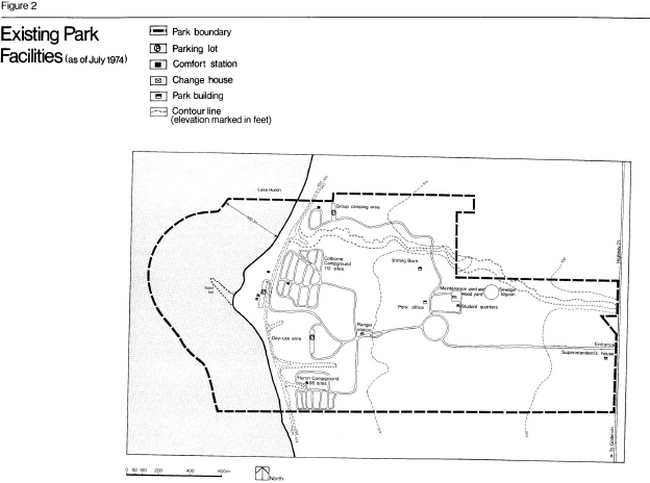
Enlarge Figure 2: Existing Park Facilities (as of July 1974)
Biophysical resources
The identification and analysis of the physical elements of a park help to determine programming and development themes compatible with the site’s natural and cultural resources. Field research and resource analysis were carried out in Point Farms Provincial Park during the summer of 1974. The research, which will be updated and expanded continually indicated a lack of biologically, geologically or geomorphologically unique features of any provincial significance within the park.
The park land base is an open grassland field stretching from Highway 21 to a hardwood-covered bluff near the shoreline. The bluff drops steeply to a sand and pebble beach. The beach and bluff are good examples of certain geomorphological processes and, consequently, present opportunities for interpretation of the local area’s glacial history and fluvial features (Tracey, 1974). Four gullies have cut into the bluff forming steep-sided ravines. The vegetation of the park has been significantly influenced by man’s activities and, thus, tree cover is quite limited on the park property.
Climate
Point Farms lies within the Lake Huron-Georgian Bay climatic region of Southern Ontario (Brown et al, 1968). The proximity of the lake has a great influence on the weather at the park. It causes the daily range of temperature to be less and the mean annual temperature to be greater than the temperatures at sites farther inland. Other general climatological statistics for the Point Farms region include an average annual precipitation of 83.6 cm, with 62 cm of this falling as rain; an average temperature for July of 24° C and for February of –6° C; and an average of 218.4 cm of snow falling anywhere from late October until May. The prevailing wind direction is south-southwest at a speed of 16 kmph. Bright sunshine averages 1,750 hours per calendar year out of a possible 4,470 hours.
The weather pattern is undoubtedly one of the more critical factors influencing the type and degree of visitation to the park. For example, during 1972, a summer of cool, wet weather, there was a decline in the number of campers and camper days at provincial parks in contrast to the continual increase in camper numbers from 1957 to 1971 (Ontario Provincial Parks Statistical Report, 1972). Similarly, on holiday weekends, the demand for campsites at Point Farms is heavy unless the weather just prior to the start of the holiday weekend is cold or damp, or if the weather forecast indicates the prospect of a cool, wet weekend. Under these conditions, camping demand is substantially decreased.
At Point Farms, the dominant visitation period occurs during the summer. From June to September, the average maximum temperature is 22.5° C, which indicates a pleasant daytime temperature for activities ranging from camping to sunbathing to walking. At times the sun can become oppressive because of the lack of natural shade on the beach and upland plain area. The average minimum night temperature for this period is 12° C. Although rainfall is fairly evenly distributed, a slight precipitation concentration occurs in the fall and winter seasons. In July, on the average, 280 hours out of approximately 320 hours of visible sunshine are bright sunshine. The lightest winds, about 14 kmph, are experienced during July and August, and their dominant direction varies between south and west. These light breezes prevent the temperature and humidity from becoming oppressive. Nonetheless, strong winds and rainstorms occur at intermittent intervals. Generally, the pleasant summer weather conditions at Point Farms are conducive to outdoor recreation activities. A second pleasant feature of the park is the beautiful sunsets over the lake.
While the park area receives ample amounts of snow for winter recreation enthusiasts, the period from November to March also experiences the strongest winds. In February, for example, the dominant winds come from the north and northwest at speeds of over 22.5 kmph. These winds, passing unrestricted over the open snow- covered land base, make outdoor conditions bleak at the park during the winter.
Geology and geomorphology
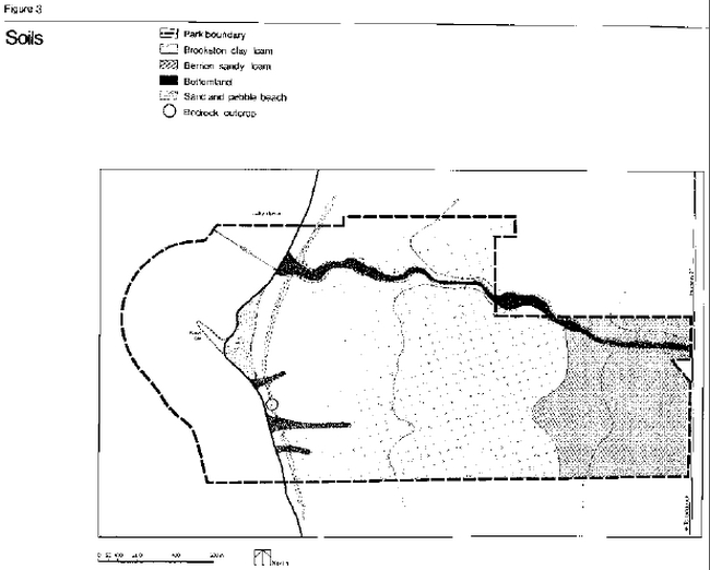
The bedrock underlying the park site, is the Dundee Formation, a middle Devonian Formation consisting basically of members of microcrystalline and crinoidal limestone (Liberty, 1971). As shown in Figure 3, bedrock outcrops at the surface in only one place in the park. This Devonian limestone contributes the fairly common fossil corals found along the beach (Karrow, 1974).
Unconsolidated material or drift, deposited during the retreat of the Wisconsin ice sheet about 13,000 years B.P. (Before Present), covers the bedrock. The park lies within the Huron Slope physiographic region which consists of a clay plain modified by a narrow strip of sand and the twin beaches of glacial Lake Warren (Chapman and Putnam, 1966). Although the Lake Warren beach lines do not pass through the park property, they are evident 9.6 km to the east, near the town of Nile.
The Huron Fringe is a narrow strip of sand which stretches along Lake Huron from the adjacent clay plain. It is composed of wave-cut terraces of glacial Lake Algonquin (12,000 years B.P.) and Lake Nipissing (5,000 years B.P.) with their boulders, gravel and sand dunes. Although the Huron Fringe does not exist within the immediate vicinity of Point Farms Provincial Park, geomorphological research, presently being carried out at the University of Waterloo, will hopefully identify which previous lake levels existed within the Point Farms area (Karrow, 1974). The report is also expected to provide an indication of the extent to which erosion has influenced the present Lake Huron shorecliff since Lake Algonquin drained away about 10,000 years ago.
The park can be divided into four distinct physical sub-units; the upland clay till plain; the Lake Huron shore bluff; the gullies and the Lake Huron shoreline.
Eighty percent of the park area consists of a broad upland clay till plain, over 20 in deep, containing a moderate amount of boulders and pebbles extending from the crest of the shore bluff to Highway 21. This clay till plain was deposited by the Huron Advance, the final ice sheet to cover the area (13,000 years B.P.). After the last glacier retreated northward, glacial Lake Warren modified the surface of the clay plan. As a result of erosion, another lake level, glacial Lake Algonquin, stabilized and created the present shore bluff in the park. This steep cliff, which represents a change in elevation of approximately 23 in between the shoreline and the level of the upland plain, runs adjacent to Lake Huron for most of the distance between Grand Bend and Point Clark. The presence of bedrock outcrops along the shoreline somewhat restricts the erosion of the Lake Huron shore bluff; the most active erosion of the bluff slope is evident in the south end of the park. The slope is partially stabilized by vegetation, but open erosion scars are common, usually caused by small-scale slumping and mass wasting.
One of the most distinctive characteristics along this section of the Lake Huron shoreline is the great number of deep gullies which cut into the till plain. The northern gully is the largest gully within the park. Its slopes have been partially stabilized by vegetation. The gullies occur primarily as a result of the steep gradient of the shore bluff, but the structural weakness of the clay also contributes to the rapidity with which erosion occurs. The effects of run-off were undoubtedly aggravated by the clearing of vegetation for agricultural purposes. These gullies are a major source of sediment for the beach, which has developed into a point separating the steep shore bluff from the lake. Ephemeral pebble and sand bars develop over the mouths of the gullies, causing partial impoundment of water from the gully streams.
An interim evaluation of the gully identified the following feature:
"a distinct terrace level approximately three meters (ten feet) below the present Warren and/or Lundy wave cut platform and yet about 4.5 to 6 meters (15 to 20 feet) above the present gully bottom" (Tracey, 1974).
This terrace level occurs not only in the park’s major gully, but also in a large gully lying to the south of the park boundary. The terrace top suggests that a meandering, possibly braided, stream once occupied this level and existed long enough to create a fairly distinct valley. These terraces are significant because they may relate to one of the glacial lake levels whose beaches have since been completely eroded, and they may prove to be important in shedding light on the glacial history of the Huron basin. A more detailed geomorphological analysis of these features is still required.
The Huron shoreline is predominantly an erosional sub-unit with a strong longshore drift from the southwest. As previously mentioned, the sandy point located at the centre of the park shoreline is a result of the collection of local sediment supply combined with the presence of a bedrock obstruction a few hundred yards south on the beach. This spit tends to deflect the prevailing currents and waves away from the shore at this location. The width of the narrow beach south of the point varies considerably with changes in lake water levels. A line of small 0.6-m high sand dunes has developed on this point, although the beach narrows again to the north.
Soils
Two major soil series, Brookston and Berrien, are represented on the till plain (Figure 3) in the park (Ontario Soil Survey, 1952). The Berrien sandy loam soil, belonging to the Grey Brown Podzolic great soil group, occurs close to Highway 21. This is a sandy outwash lying over a heavy till. Consequently, natural drainage is imperfect, and run-off is slow. The surface is characteristically free of stones within this smooth to gently sloping topographic area.
A major part of the park’s upland plain is covered by Brookston clay loam soil, a dark grey gleisolic soil frequently exhibiting poor natural drainage, a slightly stony surface and a level topography. In contrast to the upland plain, the gully floors have undifferentiated soil profiles. They are classified as containing bottomland azonal alluvial soils. The floodplain bed of the major gully consists of clay till, a result of the continual slumping and wastage of the gully sides.
According to the Drainage Guide for Ontario (Irwin and Clayton, 1973), Brookston clay loam is a soil with moderate to poor drainage qualities. Berrien sandy loam has a rapid rate of infiltration by water of 6.4 cm to 12.7 cm per hour as compared to only 0.64 cm to 2.5 cm per hour for the Brookston clay loam.
Hydrology
The waters that affect the park land base and thus indirectly affect the planning for the park, include Lake Huron, surface waters and ground waters. The waters of Lake Huron, seasonally as well as daily, have moulded the beachline affecting considerable changes in the size of the point and the composition of the beach materials. Ice action sculptures the beach during the winter. In the spring, the beach becomes covered with driftwood and alewives, which must be removed by maintenance personnel
prior to the area being used by the public for recreation purposes. The lake water is clear, relatively pure and suitable for swimming according to the water quality samples which are taken regularly off the bathing beach area around the point. Water temperatures just off the park beach vary from about 12° C at the beginning of July to 21° C at the first of August to 19° C at the end of August (Ontario Department of Transport, 1969).
Figure 3: Soils
The surface waters of the park property consist of the intermittent streams which flow from east to west within the four park gullies. These streams actively undercut and erode during the spring and fall, but dry up during summer. Stagnant puddles often remain in the largest ravine after heavy rainstorms. In general, "puddling" of the clay will occur in many areas of the park after torrential rains because the impermeable clay till has poor drainage characteristics. The clay veneer over the till creates a perched water table. This occurs where the water table in a local area is at an elevation higher than that of surrounding areas, temporarily creating standing water during wet weather.
The service facilities for the park include five drilled wells which provide water for the park and a sewage lagoon which handles the park’s effluent. The lagoon acts as a minor attractant to waterfowl (McNab, 1974). The wells, located near the bluff, vary in depth from 41.2 in to 45.7 in. The water quality of these is tested at frequent intervals and consistently shows a coliform count of zero.
Vegetation and wildlife
Within Rowe’s vegetation classification system, the Point Farms area belongs to the Huron-Ontario section of the Great Lakes-St. Lawrence Forest Region (Rowe, 1972). Within this region, the typical natural vegetation successional pattern is for white and red pine and hemlock to give way to aspen and the birch-maple-beech deciduous hardwoods. In general however, the park property is representative of much of the Lake Huron shoreline between Grand Bend and Point Clark. It has been influenced and considerably altered by the impact of man’s activities since the early 1880s, and the existing vegetation necessarily reflects this fact.
For simplicity of description, it can be stated that there are only three basic vegetational categories within the park: meadowlands on the upland plain, woodland vegetation on sections of the gullies and bluffs and dune vegetation near the shoreline.
For the purposes of more specific analysis, these elements can be identified more accurately as consisting of seven biological landscape units (Figure 4).
Within the park there is an upland plain vegetational community which is comprised of a dry meadowland landscape unit and an intermittent natural drainage system landscape unit. The vegetation occuring in the dry meadowlands covers most of the upland plain and reflects the previously varied land uses of the upland plain which have resulted in cultivated fields, orchards, hedgerows and campgrounds. The area of intermittent drainage includes a portion of the northern main gully, wet meadowland cattails and mint species and a stream-thicket type of vegetation which, although located just outside the park boundary, displays quite different characteristics from the rest of the park land base. However, this area is an integral part of the northern gully system.
There is a woodland community in the park whose vegetational landscape units include the maple-beech forest on the upland plain, cedar on the bluffs, deciduous along the gullies and aspen-ash-birch along the bluff border. The flora in the maple-beech unit consists mainly of sugar maple, beech and white birch, with several varieties of flowering plants. This maple-beech hardwood forest is the only area of climax vegetation in the park. Typical trees in the cedar bluff area are northern white cedar, white birch, hemlock and aspens in addition to shade-tolerant woodland plants and creeping shrubs. Sugar maple, ironwood and basswood thrive within the five park gullies while white ash and aspen predominate along the bluff border. This last landscape unit also consists of some white birch, chokecherry shrubs, apple trees and pear trees.
Figure 4: Biological Landscape
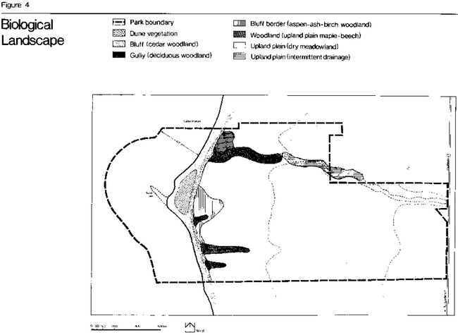
Enlarge Figure 4: Biological Landscape
The third vegetational community occurs on the 0.6-m high dunes near the shoreline. There is only one landscape unit in this area which is comprised of sparse vegetation with a few aspen, juniper, willow and birch species, as well as some grasses (Ter Haar Romeny, 1974). The only other distinctive area on the shoreline is the pebble beach which is devoid of any vegetation.
It is evident that the vegetation of Point Farms Provincial Park does not contain any unique or regionally significant features. However, the wooded areas, although limited in extent, contribute significant aesthetic appeal to the park. The mature vegetation of the maple-beech hardwood stand will be carefully managed in order to attempt rehabilitation of this area which suffered severe degradation and soil compaction as a result of past camping activities. Attempts will also be made to ensure that further degradation of the southern bluff slope, which is highly susceptible to erosion, will not take place. The herbaceous plants growing along the base of the bluff slope will be identified as part of an interpretive walking trail. The fragile sand dune vegetation on the shoreline will be protected wherever possible.
Wildlife within Point Farms Provincial Park consists of fairly common species. Red fox, white-tailed deer, shrew, weasel, european hare, cottontail rabbit, deer mouse, groundhog, muskrat, raccoon and skunk can be seen on occasion on the upland plain. Birds frequently sighted include the sparrow, robin, bobolink, meadowlark and killdeer, while the sandpiper and mallard and black duck can be seen infrequently near the park lagoon. The stream in the northern gully supports some species of minnows such as the shiner and chub.
Some of the characteristic smaller fauna species which reside in the wooded areas are the eastern chipmunk, red squirrel, cottontail rabbit and such woodland birds as the woodpecker, thrush, baltimore oriole, warbler, scarlet tanager, and rose-breasted grosbeak. The sandpiper and gull inhabit the shoreline community (McNab, 1974).
Cultural resources
Historical context
Point Farms Provincial Park does not rank as a regionally significant historical landmark, but it does contain some cultural resources of local interest. The cleared fields and the remains of some foundations of old farm buildings are all that remain to represent the agricultural development that took place in Huron County (Figure 5). The Point Farms area gradually changed from a pioneer, frontier
society during the l830s to a settled and stable rural community of the 20th century. The site of the old Point Farm Hotel is indicative of a long history of recreational land use within the park. Because of the increased prosperity in the county during the 1870s, the hotel became a summer resort for city families and a dining facility, picnic ground and holiday resort for Huron County residents until 1915 when its success declined and operations halted. These features can be used effectively by the park’s interpretive program as a means of enhancing the historical flavour of Point Farms Provincial Park.
Pre-history
Topography is a major factor governing the archaeological potential of an area, because it is indicative of the former suitability of the land base for hunting, fishing and providing shelter, water and defensive sites for early cultural groups. The topography of Point Farms is unlikely to have supported early cultural life. An archaeological survey of the park turned up no evidence of early settlement. The report concluded that this area, because it lacked a major river for fishing or transportation and exhibited an exposed beach, was unlikely to have been the site for village life or a long-term encampment.
Early settlement history
Research has uncovered four historical topics of interest with respect to Point Farms Provincial Park. These include the ownership of the land by the Canada Company, the agricultural period from the mid-1800s until 1964 when the land was purchased by the province, the era and significance of the Point Farm Hotel from 1871 to 1915 and the development and operation of the area as a provincial park from 1964 to the present.
In the 1830s, the land at Point Farms was owned by the Canada Company. However, it is not anticipated that this will constitute an important part of the park’s interpretive program as there are no physical historical resources remaining which reflect the Canada Company’s ownership of the area. The Canada Company sold the land to Baron Carel Lodewyn de Tuyle, and from the 1830s this area underwent a pattern of agricultural use characteristic of much of Southern Ontario.
A detailed account of the history of this area traces the property ownership pattern and indicates that the farming practiced was typical of the period and the region (Malis, 1974). The agricultural flavor of this area has persisted despite changing land use; this flavour should be fostered as one of the themes for the park. Although several old farmsteads on the park property do not merit historic restoration, a barn once belonging to William Stirling is still intact.
The dominant local historical theme associated with the park relates to the Point Farm Hotel. A combination of prosperity, improved accessibility and pleasant summer weather led to the growth of a modified form of early recreational vacationing, which developed in the Goderich area during the latter part of the 19th century. In 1871, J. J. Wright built a summer resort hotel at Point Farms ( Malis, 1974). Unfortunately, any physical evidence of the old hotel foundations was removed by wreckers in 1924, following the decline of the resort. However, a good visual impression of the 122-m long hemlock timber building with its 23-m central tower is preserved in photographs and artists’ sketches now compiled into a visitor services historical slideshow presentation. The old hotel access road for the hotel site and several ornamental trees are all that remain of the hotel. This area deserves protection because it was the original location for recreational land use and illustrates an important link in the continued use of the land base for recreational activities. The locally known Old Winter Hotel, which exists just outside the eastern boundary of the park, complemented some of the historical recreational activities of the Point Farm Hotel. It is believed to have served as a tavern for the Point Farm Hotel during the hotel’s temperance period, although no direct association has been conclusively established.
Point Farms became a public recreation area when most of the present land was acquired by the Province between November 1963 and January 1964. The reasons behind its selection for provincial park development included its fine beach, lake access potential and location equidistant from Inverhuron Provincial Park to the north and Pinery Provincial Park to the south. The first campground, named the Colborne Campground, was developed in 1964 and officially opened the following summer. Camping and day-use visits immediately became the dominant activities in the park. A controlled phesant hunt took place each fall until this activity was transferred to the Hullett Wildlife Management Area in 1972.
Figure 5: Historical Features
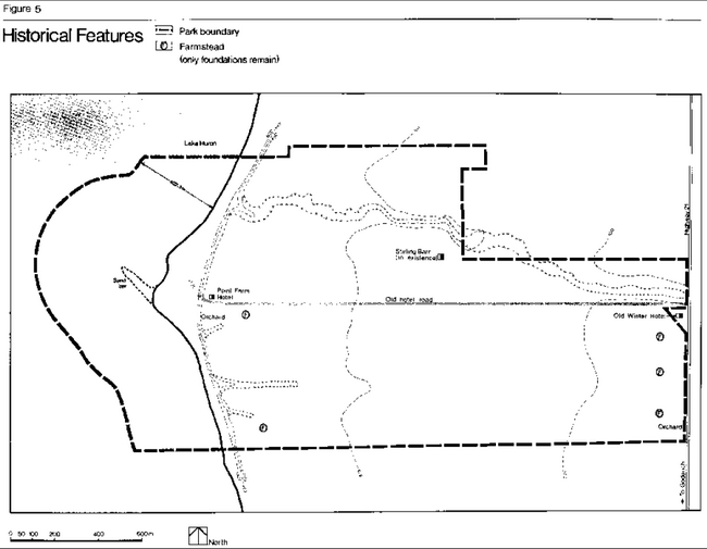
Enlarge Figure 5: Historical Features
Environmental analysis
This section identifies the environmental limitations of the park land base through an analysis of its sensitive areas, its inherent physiographic constraints and the assessment of its capabilities for development. Figure 6 outlines sensitive areas of the park which are contraints to development.
Sensitive areas are defined as those sites having aesthetic, historical, interpretive or ecological merit. They may be subject to degradation or destruction if exposed to certain types of park development. Physiographic constraints identify the physical elements which will impose development constraints upon some sections of the park. The third category assesses the capabilities of areas for development and is a partial determinant of the future development capacity of the park. Therefore, it provides guidelines for site planning and an overview of the recommended intensity of development.
Sensitive Areas
History
The old Point Farm Hotel is the most important historical site at Point Farms Provincial Park. Although no physical remains of the foundations now exist, the site should be preserved. Several ornamental trees, including an 80-year old spruce tree, which were typical of the hotel environment, still grow in the area. The old hotel access road, once leading from the highway to the front gates of the resort, is also of some significance.
The only barn remaining is one originally raised in 1889 and owned by William Stirling. The building should be preserved as a symbol of the close association of the park land base with its earlier farm use and history. The foundations of a shed used by the owner as a tool storage building and cattle slaughter house are located to the south of the barn. The well and remains of the windmill lie nearby. An old timber shack where Stirling once lived was located to the north side of the barn.
Other historically sensitive areas within the park include the foundations of several old farmsteads and their associated orchards and shelter trees (Figure 5). Because these are typical of the whole of southwestern Ontario, they should not be regarded as dominant constraints to development. However, whenever possible, these agricultural remains should be kept intact as evidence of the previous land use and also for their aesthetic appeal.
Vegetation
The maple-beech hardwood bush is presently showing evidence of severe soil compaction resulting from intensive use of the area as a campground. For example, tree roots are exposed, the soil of the campsite pads are hard-packed, ground cover is limited to the extreme margins of the grove where no camping has occurred, gravel roads divide the area, and concentrated run-off has caused a small gully to develop. Careful management involving limiting use or ending intensive use of this area, should be introduced in order to curtail erosion and rehabilitate this section of the park.
The southern cedar bluff is a clay slope exhibiting much visual evidence of mass wastage and slumping, especially in the spring. In spring and after heavy rainstorms, the clay becomes saturated with water, making it too soft to sustain the weight of a person. During the summer, the hard-baked clay forms a difficult base for plant growth. In addition, visitors have trampled and removed vegetation. The impromptu paths up and down the bluff are now the course for surface run-off and are developing into gully features. To obviate these problems and to protect this fragile area, controlled access to the beach via the bluff will be provided in order that the vegetation will have a chance to grow, and the slope, to some extent, will stabilize.
Although the plants at the bluff base are not rare species, they are of local interest within the Point Farms area. Each plant patch is susceptible to destruction by trampling or picking of the flowers. Therefore, the interpretive information program should notify visitors of the fragility of these flowers. However, these plants should not be viewed as being sufficiently significant to constitute a constraint to development.
The sand dune vegetation around the point has also been damaged by trampling. However, as this occurs in the only sandy section of shoreline within the park, it is recognized that probably very little can be done to protect this vegetation from visitor usage. Blow-out formation is not a problem at Point Farms.
The last sensitive area pertaining to vegetation is the stream thicket type of flora. Although outside the park boundary, this provides a distinctive feature of interpretive value. In the spring and early summer it is flooded and the site is marshy.
Physiographic constraints
Two major physiographic constraints within the park are the bluff slopes and the gullies. The former is quite steep and susceptible to erosion. The bluff to the north of the point is fairly well stabilized and thus less susceptible to mass wastage and slumping than the southern bluff area. However, run-off is concentrated in small gully channels leading down the slope, and as a result, these are gradually deepening. South of the point, the wet clay and slumping of the slope present development constraints. In general, the bluffs are not suitable for park facility development.
The steeply eroded banks of the gullies are very restrictive as areas for use. The bottomland of each gully, being frequently flooded, is soft, wet clay in the spring and early summer. The lip of the gully, where the bank ends and the upland plain surface begins, is quite unstable. Periodically, trees and grassy sections slump down into the gully as a result of undercutting, gradually widening the gully.
A further constraint is the clay till base of the upland plain. It is fairly impermeable and exhibits poor drainage characteristics. The clay veneer which exists in places over the till creates standing water and a perched water table during wet weather. Consequently, in high use areas, compaction of the soil breaks down the soil structure and results in mud-bowl conditions. Although better drained soils which are less susceptible to the development of clay-puddling conditions occur close to the highway, the area is too far from the beach to be considered as a potential site for the construction of campgrounds.
Figure 6: Environmental Constraint Areas
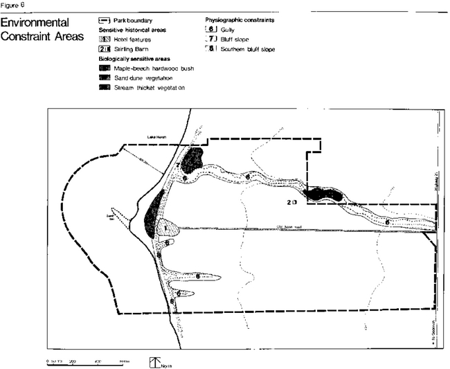
Enlarge Figure 6: Environmental Constraint Areas
Capabilities of developable areas
The purpose of the previous information was to identify sensitive areas. During the planning process, consideration of these sites assists with decision-making to determine the future development of the land base. By identifying the areas having inherent constraints restrictive to development, it becomes obvious that the remaining areas will become the developed facility locations within the park. Each of these, in turn, has specific characteristics which affect site planning as explained below in the context of the relationship of the park’s beach facilities to the proposed location for campgrounds.
Campgrounds
Campgrounds at Point Farms will be located on the upland till plain. This level, treeless, uninteresting terrain has some natural drainage problems. For these reasons, as well as to allow for the possibility of good campsite design, the campgrounds should be developed at a density of ten sites per hectare to allow for a fairly wide separation of each campsite. This design will help to reduce campsite, overcrowding and associated compaction problems.
Beach
The park beach is very limited in size and thus can accommodate only a restricted number of users before overcrowding produces a less enjoyable experience. Typically, overcrowding would most likely become a problem on a warm, sunny weekend afternoon when the campgrounds are full. At this time, it is characteristic for the campers, who make up 70 percent of all park visitors, and day-users to utilize the beach rather than other areas of the park. Therefore, a total beach capacity of 2,000 people per day is the maximum feasible limit, based on the 1.8 ha size of this beach.
Since all park visitors, including a potential 100 group campers, will be provided with equal opportunities to use the beach, the limited beach capacity has a bearing on the total number of picnic sites and campsites to be provided in the park within the environmental carrying capacity of the upland plain. Consequently, a maximum of 330 campsites and 145 picnic sites can be made available at Point Farms.
A calculation for deleting the number of campsites and picnic sites is formulated by using the maximum number of day-users (570 people) and campers (1,330 people plus 100 group campers) previously determined to equal 2,000 visitors per day These two figures, 570 and 1,330, were divided by four, the standard figure for the average party size of both camping and day-use visitors, to amve at the maximum day-use and campsite capacity for the park (McNab, 1974) Consequently, a maximum of 330 campsites and 145 picnic sites can be made available at Point Farms.
Park policy
Point Farms Provincial Park, as one unit within an overall system of provincial parks, will share in contributing to the fulfillment of the objectives of the outdoor recreation program as established by the Ministry of Natural Resources. The dominant emphasis will involve the provision of a variety of recreation opportunities centred around camping and day-use activities occurring within the context of the agricultural landscape. The existence of a few minor physical constraints related to the gully features and the bluff slope and the local historical significance of the Point Farm Hotel site, combine to direct the greatest degree of development away from these areas. The park, through its functions as a stop-over point for vacationers either heading north or returning from the Georgian Bay tourist region and as destination recreation site for local and regional populations, contributes marginally both to the local and the regional enconomies.
Park goal
Point Farms Provincial Park, by utilizing the Lake Huron shoreline and the agricultural land base, will provide the opportunity for participation in a variety of intensive recreational activities which will enrich the experiences of all its visitors.
Park objectives
- To provide year-round recreation facilities which will emphasize summer camping and day-use, with limited winter outdoor activities, in order to enhance and complement regional tourist opportunities. The present range of park activities will be expanded; the provision of a variety of types of camping and an interesting, enjoyable visitor services program will be stressed.
- To preserve and protect the inherent natural and cultural attributes of a representative section of the Lake Huron shoreline, wherever possible, while simultaneously providing an enjoyable recreation experience in harmony with the rural atmosphere of the park site.
- To provide a visitor services program which will cater to campers, day-users and special interest groups.
- To ensure permanent public accessibility to a part of the Lake Huron shoreline.
Park classification
Point Farms Provincial Park will be classified as a recreation park in accordance with the criteria established by the Ontario Provincial Parks Classification System.
This designation was selected because the environment of Point Farms is not an entirely natural one, but one altered by successive land uses. The lack of topographical and vegetational variation limits the use of the area to intensive rather than extensive recreation. Also, the park’s historical features are only of local significance. Finally, Point Farms is well located to serve as a recreation area for the visitors coming from urban Southern Ontario.
Park zoning
The zoning system, as set forth in the Provincial Parks Classification System, is a planning tool designed to ensure the orderly development and the effective management of parklands. As illustrated in Figure 7, Point Farms has been designated entirely as a development zone on the basis of the information provided by the environmental assessment.
Development zone
The development zone, as the recreational core of the park, will provide facilities for day-use and camping activities. In this case, the recreation core incorporates the entire land base of Point Farms, although certain segments of the environmental analysis contradict the park being zoned solely for development.
For example, the upland plain exhibits some surface drainage problems, but this physiographic unit is the only available land base on which campsites, park buildings and roads can be constructed. Should drainage problems arise, they will be solved by the implementation of appropriate site planning and land management techniques.
The 0.6-m sand dune area is an environmentally sensitive area compared to much of the rest of the park. However, because of the limited extent of beach at Point Farms, certain facilities, such as change houses, a comfort station and a beach patrol station, will be provided in order to accommodate intensive recreation activity in this area. The specific significance of two segments of the park is recognized by the designations of an historical area and a fragile area as sub-components within the development zone.
The historical area consists of the site of the Old Point Farm Hotel and its immediate environs lying on either side of the Old Hotel Road just above the bluff. The site is bounded to the south by a small gully and to the north by the present Colborne Campground. The hotel story and its link with early recreation within the Point Farms region are the dominant historical themes within the park. Designation of this site as an historical area protects it from heavy development. Its interpretive value will be preserved and it can continue to act as a visual reminder of the land base’s long association with recreation.
Figure 7: Zoning
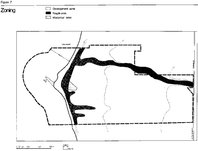
The fragile area includes the whole of the bluff slope and the gullies. This section of the park will have no use or a very minimal activity function because it can not accommodate buildings, construction or intensive recreation activity.
The bluff, which divides the upland plain from the beach will have to serve as an access route to the beach. However, the access will be controlled and visitors will be directed to constructed steps or the road in order to prevent damage to the fragile bluff slope. The base of the bluff will serve as a pleasure walking and interpretive trail since it is one of the few areas within the park where trees, topography and flowering herbaceous plants combine to form an interesting biological unit with considerable aesthetic and shade appeal.
The gullies have also been included within this fragile area designation because of their delicate banks and associated vegetation. No trail systems will be developed within the gullies. Visitor access will not be encouraged, and any interpretive visits to these ravines will be made under the supervision of park personnel.
Development program
In considering the future for Point Farms Provincial Park, the functions of several parts of the park were virtually predetermined by the restrictive nature of the land base. In addition, the resource potential serves best as a recreation-oriented provincial park. In consequence, it was not realistic to propose widely differing alternative concepts for the development of Point Farms. Instead, three alternative design variations were presented based on the one recreational development theme. The variations, as discussed in Appendix B, were obtained by changing the locational pattern of the same set of park facilities.
Variation 3 was selected as the optimum pattern which would permit the efficient and convenient use of all facilities and services within the park. This variation is the basis of the master plan for Point Farms Provincial Park. The following is a description of development which will occur within the park (Figure 8).
Access and internal circulation
A new park access road and entrance will be designed because the present alignment is hazardous. A dip in the existing road surface of Highway 21, just north of the park, obscures the view of oncoming highway traffic near the present park entrance. In addition, at this point there is no deceleration lane on the highway. A store, located almost opposite the entrance, further adds to the traffic congestion. The relocation of the Point Farms access route, to approximately 256 m south of its present position, would alleviate some of the existing dangers. Also, negotiations with the Ontario Ministry of Transportation and Communications will be undertaken to construct a deceleration lane at the entrance. The entrance, access and main park road will be designed by the Ministry’s site planning staff and will be in keeping with the park theme.
One objective of the redesign of the main park road will be to gradually reduce the speed of traffic approaching the developed sections within Point Farms. The new park road will incorporate as much of the existing paved surface as is possible while designing a safe yet attractive winding roadway. Apart from reducing the duplication of expensive roadway construction, this would leave an open field area to the south of the road, which would have a dual function as a site for extensive recreation and as a visible reminder of the agricultural facet of the park theme.
When it becomes necessary to remove the beach parking lot, the access road to the beach will end in a turn-around circle. The access road to the campsites will utilize part of the old hotel road.
Figure 8: Master Plan
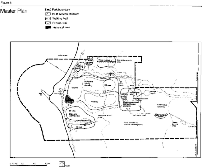
Parking areas
A 30-car parking lot for the campground will be located above the shoreline bluff in the southwestern corner of the camping area. This will accommodate the additional vehicle of those parties which have two cars per campsite. It will also accommodate the cars of visitors to the campground and those campers from the eastern campsite loop wishing to drive closer to the beach before proceeding to walk down the bluff.
Some parking will also be provided in the day-use section of the park. The two picnic areas in the south-central part of the park will contain 90 parking spaces in the larger lobe and 60 spaces in the smaller lobe serving the picnic area. The beach parking lot, on the other hand, will be removed at a future date when the number of day- users on the beach during peak park visitation periods is approaching 2,000 people per day. At this time, the parking area will be rehabilitated to serve as recreational space. A turn-around circle will remain at the beach end of the access road to facilitate senior citizens and those wishing to drive down to the beach to deposit their party members and equipment before parking in the lot above the bluff.
Parking for 50 cars will be provided at the visitor centre and this lot will be lighted at night.
Camping areas
During the traditional camping season, a variety of types of camping, including individual family sites, cluster family units, a group campground and detached walk-in sites, will be provided at Point Farms. There will be no provision for winter camping. This policy will be reviewed periodically and may be subject to revision as conditions and demands change.
Approximately 314 individual family camping sites will be centrally located in one campground above the bluff on the upland plain. The number of sites was determined relative to ecological restrictions, site planning standards and land availability. The sites, located at an average density of 1.6 per ha, will consist of a cut-grass campsite pad which may be converted to a sand and organic matter base when degradation of the natural vegetation occurs. Each site will include parking-space for one vehicle. Three campground loop service roads will divide this campground. Adequate comfort station and shower facilities will be provided at locations convenient to the greatest number of campsites. A maximum of 50 percent of the sites will have electrical outlets. Provision will also be made for tap water to be supplied to the campground. A trailer dumping station and water-filling service, which presently exist to the south of the campground, may require relocation pending site plan consideration.
In keeping with the agricultural flavour of Point Farms, the campground design will utilize different types of farm fencing to landscape and divide the campground. Buffer trees will be required to provide privacy on each site, while berms, created in the process of road construction, may be used to artificially vary the landscape.
One group camping area, covering approximately two hectares will be designed to serve a maximum capacity of 100 campers. The sites will be buffered to form enclaves such that two or three separate small groups could be accommodated at the same time without causing inconvenience to one another. Water taps, fire grates and four vault privies will be installed. Parking will be incorporated into the site plans for this campground.
A maximum of six detached walk-in campsites will be provided in the maple-beech hardwood grove. The locations of these sites within the grove will be altered frequently and will require minimal development to ensure against environmental damage. A comfort station already exists outside the treed area.
Since access for vehicles will be prohibited, the existing central gravel road within the grove will be removed. Parking space will be available in the parking lot located at the group campground. Only light tents will be permitted, and visitors using the area will pack their own garbage out of the grove. A pamphlet explaining the fragility of this section of the park and the need for its careful management will be distributed to all walk-in campers.
The cluster family camping area will contain approximately 12 camping units in groups of two to six sites, depending upon site planning specifications. Normal campsite facilities and electrical outlets will be provided. The campers will utilize the existing comfort station previously mentioned in connection with the detached walk-in campsites. An open space for play and social interaction will be left in the centre of each unit of campsites.
Day-use areas
The day-use sections of Point Farms, including the two picnic area lobes in the south-central part of the park and the beach, will provide standard picnic facilities in harmony with the park environment.
The former will incorporate, at a density of 3.2 picnic sites per ha, 90 picnic sites in one lobe and 60 in the second. Each site will have a table, barbecue and garbage container and the largest lobe will contain a picnic shelter.
Consideration should be given to the possibility of constructing small picnic shelters in this area which accommodate only two or four families in order to add interest to the otherwise flat topography.
Also, the day-users at Point Farms are characteristically single family groups; very few large picnic groups are attracted to this park. Small shelters, providing an element of shade from the sun, would, on a hot day, offer welcome relief from a very open, exposed landscape. Furthermore, they would add interest and variety to the picnic area, thus promoting this site as an attractive, viable focus for day-use recreation which could intercept some of the demand presently concentrated on the limited beach space.
Other facilities will include flush toilets, drinking water and a creative playground. Again, the agricultural flavour will predominate throughout this site.
The beach will be the focus for swimming, sun-bathing and walking. Two change houses and a comfort station located on the sand dune area of the northern section of the point will serve beach-users. No boat launching ramp will be provided, but car-top boats can be set afloat from the beach. Good boating facilities are located nearby in Goderich, and fluctuating lake levels make it technically and financially impossible to maintain a launching ramp on the shoreline.
A maximum of eight picnic tables will be strategically located in the treed area at the base of the bluff near the point so as to be remote from the sensitive patches of interesting vegetation identified by the park biological inventory. Visitors will be encouraged to picnic at the day-use area on top of the bluff.
A playground will be developed on the beach. It will incorporate the natural elements of the environment, water, sand, pebbles and driftwood. This playground is necessary because the beach, composed predominantly of pebbles, is not naturally a suitable playground for very young children. An element of shade will be incorporated into the design of this feature.
Experimental dune vegetation protection plots will attempt to preserve the fragile dune plant cover. Their locations will be marked out by fencing and altered every three years.
The historical area
The approximate foundations of the Point Farm Hotel will be marked out by indicative cornerstones. An attractively-designed informative display and/or model of the hotel will be located on this site. A maximum of three picnic tables will be placed within the hotel environs, but no parking space, toilets or fire grates will be provided. A creative playground, portraying historical recreation in the area and the Point Farm Hotel, will be constructed on the boundary between the campground and the historical area. The Fragile Area
The gullies are minimal use areas; any interpretive viewing will be conducted from outside the main gully. The headward section of this feature will not be dredged in order to speed up drainage, as this would increase the process of erosion farther down the gully. Experimental attempts at stabilizing the banks could form part of an interpretive program. The stream thicket lying adjacent to the main gully is presently outside the park boundary. An easement should be negotiated with the landowner in order to facilitate interpretive viewing of this ecologically interesting environment.
Development on the bluff will be restricted to the provision of walking routes to the beach. Well- designed and maintained wooden stairways will lead visitors down clearly defined routeways. Wooden stairs are environmentally less damaging and easier to keep in good repair than cedar log steps. The position of the stairs will be clearly marked by signs at the top and bottom of each flight of steps. Rest benches could be located on two of the stairways. When it becomes necessary to eliminate all parking on the beach, a mechanically-operated lifting device will be installed to ease the climb up the steep bluff for some senior citizens, the physically handicapped or other park visitors.
Trails
A pleasure-walking trail will be developed along the southern lip of the main gully well back from the unstable edge. The trail will be a cut grass treadway. This will link the campsites to the campfire area and activity barn. It could be used as an interpretive trail for viewing the process of erosion and supplemented by the construction of a raised, viewing platform at an appropriate site. The precise location of the trail will be varied annually in order to prevent ‘mud bowl’ conditions from developing.
A self-guided nature trail will follow the base of the bluff. A carefully designed 2.4-km fitness trail consisting of 12 exercise stations will be constructed at a location readily accessible to large numbers of park visitors.
Open fields
Open field areas will be regarded as representative of the park’s agricultural-historical theme and will be left as such. The fields lying between the eastern boundary and the maintenance complex will continue to be rented to local farmers for cropping. This is in keeping with the agricultural park theme. Clump tree planting will occur in the other open fields as recommended by site planning in order to improve the aesthetic value and shaded sites within the park. However, the ultimate intention is not to create a completely tree- covered area. Rather, the agricultural integrity of the park is to be fostered.
Hedgerow divisions and fencing will be utilized in order to subdivide the large open fields into sections varying in size from three to eight hectares. These divisions would be aesthetically pleasing and they would indicate the type of landscape that existed in pioneer times. Also, the hedgerows would provide additional wildlife habitats.
Architectural theme
Maintenance and administration buildings
What was formerly student’s quarters will be converted to become the park administration office. A parking lot to accommodate the cars of park personnel and visitors will be situated in this area according to site planning specifications. The road system will be designed such that all service vehicles will be required to pass this office upon entering or leaving the maintenance complex.
A new cold storage maintenance building consisting of four bays will be constructed. An open working space will also be provided within the complex. No parking will be allowed in this area; all staff will park outside the perimeter fence. The road between the present woodyard and the present park office will be closed.
The superintendent’s house will be removed from the park.
Permit control structure
The present park office will become the campground and day-use control office. This will require a major redesign of the facility in order that peak period entrance traffic may be handled with ease. Pre- registration selection of campsites may be instituted so that campers select their campsite from a detailed map shown to them at the control office prior to their admission to the campground.
Visitor centre
The visitor centre for Point Farms Provincial Park will be located in the Stirling Barn. This building will be renovated to accommodate various visitor service activities including audio-visual productions, barn dances, displays and interpretive talks. The interior design of the centre will reflect the park’s agricultural hertiage.
Signage
The signs used within the park will correspond to the standard form used within the Provincial Parks System. They will be used to orient park visitors, to ensure public safety and to supplement visitors services programs. They will be designed in keeping with the agricultural theme of the area.
Washrooms
Comfort stations and shower facilities will be developed in the individual family campground. The detached walk-in and cluster family camping areas will be serviced by the existing comfort station, while vault privies will be constructed in the group camping area. In addition, the comfort station on the beach will remain. The design of the comfort stations and shower building will reflect the agricultural theme of the park story whenever possible.
Visitor services program
The following constitute guidelines for the visitor services program at Point Farms. Prior to the implementation of this program, a Visitor Services Management and Operations Plan should be prepared.
Point Farms will operate a "seasonal activity" program from May to September, involving one to three recreationally-oriented staff members. The emphasis will be on encouraging users to obtain maximum enjoyment from the park and surrounding area by providing a comprehensive communications program and innovative recreational opportunities.
There is a close relationship between the physical landscape and the changing pattern of agricultural and recreational land uses in the Point Farms area. Because of the recreational nature of the park, the program will evolve around the theme "past and present recreation within a changing rural environment".
The role of the four components of the visitor services program will be as follows:
Communication
Communications will play an integral role in the park program. All park staff will be prepared to familiarize users with the park’s operations, facilities and programs, points of interest in the local area, regulations and various resource management practices. A well-designed system of publications, audio- visual productions and signage will be used to supplement this information.
Visitor services staff should, through campsite visitations and "drop-in" sessions be approachable and readily accessible to park visitors in order to encourage open communications. Maximum advantage should be taken of the opportunity to communicate messages to the large groups who are attracted to various recreational programs and special events.
Pictures, displays and other facilities used to communicate the visitor services program should reflect the park theme. All architecture should also communicate the same theme. In addition, the park’s logo, designed to emphasize the rural-recreational theme of the Point Farms land base, should be used on future park publications (Figure 9).
Recreation
In accordance with the park’s recreational classification, the visitor services program will provide a variety of recreational opportunities. The major emphasis will be placed on the provision of conveniently located self-use facilities that help visitors to explore and enjoy the park. Facilities will include adventure playgrounds, sports fields, a softball backstop and a campfire facility with seating for approximately 100 people. In addition, a limited amount of equipment such as volleyballs, badminton racquets and birds, soft balls and bats, soccer balls and horseshoes should be made available upon request. Priority should be given to those activities of a traditionally rural nature.
Staff-organized program should be limited to typically rural activities. These include barn dances, campfires, horseshoe tournaments and handicraft demonstrations. Other activities, inconsistent with the park theme or of a non-participatory nature, are considered inappropriate and will not be encouraged.
The renovated barn will become the focal point of the visitor services program and its architecture and decor will reflect the rural recreation theme. It can subtly orient visitors to the park history and to the opportunities available for further exploration. The centre can provide a sheltered area for socializing, rainy day activities, displays, handicraft demonstrations and evening programs. However, recreational activities should not be confined solely to this area because it is located some distance from the campground.
Interpretation
A limited number of facilities will be used to interest visitors in the regionally-significant historical and rural stories of the area. These stories can be explained through interpretive publications, such as the History of the Point Farms Area, and displays, such as barn building tools.
Staff-organized interpretive programs will be discouraged in favour of more low-key, self-help, active recreational programs which correspond to the rural theme. Special events utilizing outside expertise will be encouraged provided there is adequate monitoring and supervision available from the park.
Outdoor education
The resource base of the park may be utilized by local schools for outdoor education purposes. School groups wishing to visit Point Farms for outdoor education purposes should notify park authorities prior to their visit. In this way, suitable scheduling of groups can be accomplished. District and/or visitor services staff will provide orientation to teachers or group leaders upon request.
In general, the visitor services program at Point Farms will be low-key and flexible to ensure that services and facilities are provided for the greatest variety of visitors, day-users, campers, tourists, family groups and senior citizens. In order to maintain a topical, frequently changing program, appropriate related research will be initiated as required.
Figure 9: Park logo
The 1976 Visitor Services Policy (Interim) (Ontano Ministry of Natural Resources, 1976) suggests that major programs should be confined to selected parks, termed nodal parks, which can supply manpower and equipment to other parks with smaller satellite programs The Point Farms Provincial Park visitor services program will be largely self-sufficient, although the occasional programs may be operated by staff from MacGregor Point Provincial Park The relationship between these two parks should be clearly defined in the management and operations plan
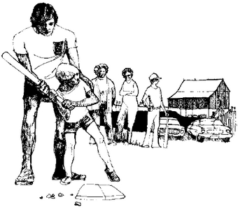
Park operation and management
Staff
Once the master plan is fully implemented, a complement staff position for a park superintendent will be required at Point Farms Provincial Park. Enforcement services, as necessary, will be co-ordinated by a conservation officer assigned to the park from the district complement during the park operating season. Co-operation between the park, the Hullett Wildlife Management Area and the Lucknow River Fishway at Port Albert will exist so that the interpretive naturalist based at Hullett will visit Point Farms on a regular schedule during the park’s operating season in order to integrate programming for these areas.
Seasonal staff will be hired, from season to season, as the need is identified, to fulfill duties related to the visitor services program, maintenance, permit issuance, enforcement and security patrols. Staff scheduling for all park personnel will be determined for the entire summer season prior to the commencement of operations in May.
Park services
Water
Five drilled wells supply the water for the park. This water is tested regularly. A pressurized water system supplies the comfort stations in each campground.
Sanitary facilities
A sewage lagoon, located near the administration complex, services most of the park. It accommodates liquid wastes pumped from the comfort stations and is evacuated periodically by a sprinkler system. Two small tile beds exist near the permit office and the maintenance complex.
Hydro
Most of the main hydro lines are above ground, but they will all eventually be relocated underground. The lines recently installed for the administration office were placed underground.
Telephone
The telephone system consists of installations in the permit office and the maintenance and administration buildings. The telephone lines permit incoming and outgoing calls as well as internal calls between buildings to facilitate park operations.
Fire protection
Point Farms is served by the Goderich Fire Department. The park also possesses it own fire- fighting equipment, and staff are trained in the basics of fire protection and fire-fighting.
Emergency services
All reasonable precautions will be taken to ensure the safety of park visitors. A first-aid station is located in the park. Ambulance service is available from Goderich. Although the park will provide its own policing service, the nearest Ontario Provincial Police detachment, located in the town of Goderich, will be available to render assistance if necessary.
Plan implementation
Phasing of development
Within an operating park, construction work is generally carried out in such a way as to minimize disruption of visitors during the normal camping season. At Point Farms, development will be phased to ensure that a full range of camping and day-use opportunities will be available to visitors at all stages of construction. Existing capital intensive facilities will be utilized wherever possible. For example, the existing Huron Campground comfort station will be incorporated into an interim usage pattern until the effective life expectancy of the facility has terminated.
Phase I
| Priority for Site Planning and Implementation | Facilities to be Developed | Specific Directives |
|---|---|---|
| 1st | Visitor centre | The barn will be developed as an activities centre. Parking, lighting, toilets, picnic tables and a play area will be provided. |
| 2nd | Administration building | The existing student house will become the park administration office and the former park office will be redesigned to become the main camping control office. |
| 3rd | Maintenance area | The existing maintenance area will be expanded and upgraded. |
| 4th | Camping area | Two campground loops with 200 new individual campsites will be developed. The Colborne Campground with 112 sites will be retained as the third loop. The necessary park services will be developed in conjunction with the new campgrounds. |
| 5th | Park access road | A new park entrance and access road will be designed and developed. |
| 6th | Shower facilities | |
| 7th | Day-use area | In the existing open space lying to the north of the Huron Campground, approximately 90 of the 150 picnic sites and parking spaces will be developed. |
| 8th | Cluster family camping area: -Group camping area -Walk-in camping area -Playgrounds -Historial area -Campfire area -Fitness trail -Sports field |
Site design and development of these facilities will occur, when feasible, within the normal scheduled park operating routine. |
Phase II
| Priority for Site Planning and Implementation | Facility Affected | Specific Directives |
|---|---|---|
| 1st | Camping and day-use areas | The present Huron Campground will be removed and the second day-use picnic area of 60 sites will be developed. |
| 2nd | Administration | The remaining residences will be removed. |
| 3rd | Parking areas | The beach parking lot will be removed if pressure on the beach indicates that this measure is desirable. |
| 4th | Recreation facilities | A sports field near the barn, lying to the north of the bridge, will be developed. |
Site plans
Site plans will be compiled to determine the location, on-site design and density of all campsites, parking lots, service buildings, play areas, roads and trails to be constructed at Point Farms. Site plans are designed and formulated by the Site Planning Unit of the Division of Parks, Ministry of Natural Resources. These plans will take into consideration the biophysical and cultural resources which determine a site’s capability to accommodate activities and facilities appropriate to the park.
Management/operating plan
The park employees, under supervision of the park superintendent, will ensure the efficient and orderly operation of the park during the designated operating season. A series of detailed scheduling procedures will be compiled by the superintendent and articulated within the park operating plan in order to optimize service provision and the maintenance of park facilities and biophysical resources.
Past experience in the operation of the park and observations concerning user trends dictate that the following directives should be established to guide management practices within the park.
- The fragile gully areas will involve resource management related to the discouragement of visitor use and the stabilization of the gully banks.
- A rehabilitation program will be introduced in the maple-beech grove.
- The tree-planting program will be carried out in a manner consistent with the park’s rural setting. Indigenous species will be used to buffer campgrounds, while clump planting will relieve the monotony of the upland plain.
- The upper course of the main gully stream will not be dredged, as this would speed up erosion further down the gully;
- The picnic tables at the base of the bluff will be strategically located so as to minimize environmental damage;
- The park will be designed so that during low visitation periods certain visitor sections can easily be closed off in order to obviate unnecessary maintenance operations.
- In order to facilitate the implementation of park development through phasing, one or two of the campsite 1oops may be temporarily closed and left unserviced.
- When there is a sufficient ground cover of snow, snowmobiling will be permitted, but only on designated park roadways and specifically designated sections of the upland meadows. Areas for snowmobiling will be marked by a signage system. It is essential that snowmobilers adhere to designated routeways in order to avoid hedgerows, fences, young tree stock and tree support stabilizing wires. The park’s policy on snowmobiling will be subject to periodic review.
- Hunting of upland game and migratory birds in season will be permitted within the park.
However, the amount of game available is very limited and is not expected to attract many visitors. Controlled pheasant hunts will not be held at Point Farms. The policy on hunting and its management at the park will be subject to periodic review.
Visitor services plan
As part of the implementation process, a visitor services plan will be compiled as specified within the Visitor Services Program section of this master plan.
Research and future studies plan
Several on-going studies will be instituted within Point Farms Provincial Park. These will include:
- a more extensive earth sciences report;
- an annual program to measure and monitor the process of erosion in the gullies, the bluff and the lakeward margin of the sand dune area;
- a program designed to monitor the effect of heavy use on the newly developed campsites;
- the monitoring and review of hunting and snowmobiling activities;
- research into the Old Winter Hotel property which exists just outside the present park boundary to determine the historical significance of this site
The findings of these studies Will supplement Visitor services program materials and Influence the park management and operating plan.
Appendix
Appendix A
Public participation program
The public participation program incorporates an open planning process into the preparation of master plans. It attempts to produce a viable plan that has the support of the public.
In view of the fact that Point Farms Provincial Park is a minor park within the Ontario Provincial Parks System and that the master plan is concerned only with internal developmental changes within the existing park property, the public participation program consisted primarily of meetings with the two local councils. Ministry officials presented the preliminary plan to the Goderich Town Council in June 1974, and Council members were asked to forward any responses or comments from the local residents to the Ontario Ministry of Natural Resources District Office in Wingham. In July 1974, the plan was presented to the Township of Colborne, and the council members were again asked to represent the local citizens concerning any questions or objections that might possibly be raised.
Further information was provided to the public through two separate interviews broadcast on Radio CKNX, Winghain which presented progress reports on the master plan and requested feedback from interested individuals.
Park users were approached during the summer of 1974 by way of informal discussions to discover the visitors’ feelings concerning Point Farms and desired park activities.
All comments received from the public were given full consideration prior to the completion of the final master plan document.
Appendix B
Variation alternatives
The preparation of three variations for proposed park development involved an evaluation of alternative locations for the campgrounds and day-use picnic area. Consequently, differences in the three variations related to optimising the functional relationship of various components of the park rather than a selective choice from varied levels of services or facility provision (Figure 10).
The following set of facilities and services were standard and inherent to each variation: access to the beach; a day-use picnic area covering 8 ha for a maximum of 150 families; enough camping sites to accommodate a maximum of 320 parties at a density of 1.6 sites per ha; a group campground to accommodate a maximum of 100 campers; provision for a variety of types of camping experiences; visitor service facilities; park administration and maintenance services; and a road circulation system. The variations which were considered had to ensure that the park would include all of the following: no development in the gullies; minimal use of the bluff; a swimming area and limited picnicking facilities on
the beach; an historical interpretive site; and a maintenance and administration complex located at some distance from the bluff so that visitor-oriented facilities could be located as close to the beach as possible.
Variation 3 was selected as the basis for the park master plan and has been described in detail within the master plan chapter. For comparative purposes, a synopsis of the other variations that were considered follows:
Variation 1:
- The day-use picnic area to be located in the north section of the park. It would provide tables, barbecues, a picnic shelter and toilet facilities.
- The group campground to be located in the south of the park between the park boundary and the edge of the bluff.
- Individual family camping to occupy a central position between the group camping and day- use area. It would contain comfort stations, showers and a playground.
- The walk-in campground to be located in the maple-beech hardwood grove.
- Cluster family camping to be accommodated close to the group camping area.
- The Stirling Barn to act as an activity centre.
Figure 10: Concept Variations
Variation 2:
- Group camping to be located in the northern section of the park.
- Walk-in camping to be accommodated in the maple-beech grove.
- Cluster family camping to occupy the open land lying to the north and east of the maple-beech grove.
- Individual campsites to be concentrated into one campground with three loop roads around the sites. Campground to be located between the bluff and the Stirling Barn.
- The site of the day-use picnic area to be to the south of the campgrounds. It would consist of two lobes of development which would be situated on either side of one of the minor park gullies.
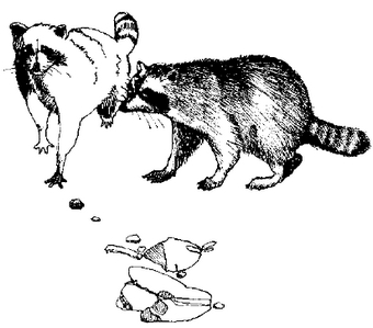
Selected references
Chapman, L. J. and D. F. Putnam. The Physiography of Southern Ontario. (2nd ed.) Toronto, University of Toronto Press, 1966.
Irwin, R. W. and R. C. Clayton. Drainage Guide for Ontario. Toronto, Ontario Ministry of Agriculture and Food, 1973.
Karrow, P. F. Glacial Lake Levels in and around Point Farms Provincial Park. (unpublished letter), 1974.
Liberty, B. A. Paleozoic Geology of Wolfe Island, Bath, Sydenham and Gananoque Map-areas, Ontario. Ottawa, Canada Department of Energy, Mines and Resources, 1971.
Malis, L. History of Point Farms Provincial Park. Wingham, Ontario Ministry of Natural Resources, November, 1974.
McNab, W. L. Point Farms Provincial Park, Preliminary Park Master Plan. Wingham, Ontario Ministry of Natural Resources, August, 1974.
Ontario Ministry of Natural Resources. Huron County Shoreline Study. Toronto, 1974.
Ontario Ministry of Natural Resources. Ontario Provincial Park Statistical Reports. Toronto, 1970-1975.
Ontario Ministry of Natural Resources. Provincial Park Visitor Services Policy Programme (Interim Policy). Toronto, 1976.
Rowe, J. S. Forest Regions of Canada. Ottawa, Ministry of Environment, Canadian Forestry Services Publication, 1972.
Ter Haar Romeny, B. Life Sciences Resources Inventory Report, Point Farms Provincial Park. Wingham, Ontario Ministry of Natural Resources, 1974.
Tracey, A. C. Point Farms Provincial Park Miscellaneous Report. Vol. 5, No. 5. Toronto, Ontario Ministry of Natural Resources, Environmental Planning Series, 1974.
Warren, W. D. Comments on the Geology of Point Farms Provincial Park, Huron County, Ontario. Toronto, Ontario Ministry of Natural Resources, Earth Sciences Report, Park Planning Branch, 1974.
Footnotes
- footnote[1] Back to paragraph An isochrone is an imaginary line joining all points at an equal travel time distance from a location.