Porphyry Island Provincial Park Management Statement
This document provides policy direction for the protection, development and management of Porphyry Island Provincial Park and its resources.
Reference Copy
Additional copies of this publication are obtainable only from:
Thunder Bay District Office
P.O. Box 5000
Thunder Bay, Ontario
P7C 5G6
Telephone: (807) 475-1531
1991 Government of Ontario
Regional director’s approval statement
Porphyry Island Provincial Nature Reserve
This revised Interim Management Statement will provide interim direction for the management of the above Provincial Nature Reserve until a comprehensive Nature Reserve Management Plan is prepared.
This statement will provide the basis for the subsequent preparation of the Nature Reserve Management Plan.
I am pleased to approve this Interim Management Statement.
Signed by:
M.S. Millar
A/Regional Director
North Central Region
Revised March 1991
Background information
Date: 21.03.68
| Name: | Porphyry Island |
|---|---|
| Class: | Nature Reserve |
| M.N.R. District: | Thunder Bay |
| M.N.R. Region | North Central |
| Total area (ha): | 107 |
| Land: | |
| Water: | |
| Site region: | 3W |
| Site district: | 3 |
| Date in regulation: | March 21,1968 |
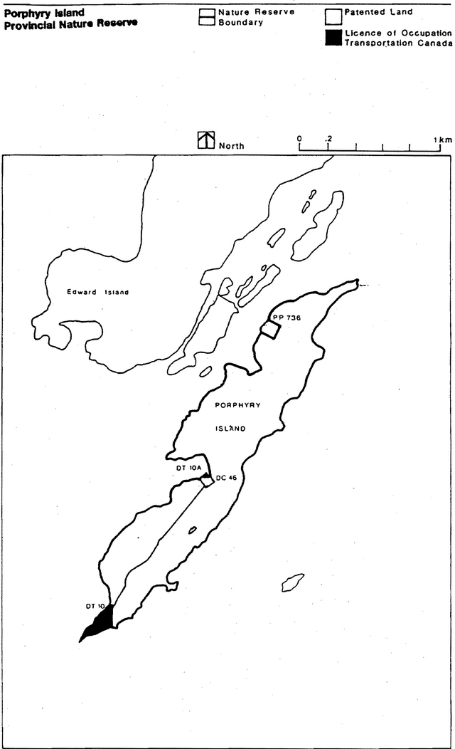
Figure 1: Porphyry Island Provincial Nature Reserve
Targets
Life science representation
| site type/ landscape unit | species/communities |
|---|---|
| Rare and endangered species occurrences: Oplopanaz horridus (Devils Club); Vaccinlum ullginosum (Alpine Bilberry); Circium drummondl (Drummond’s Thistle); Pinguicula vulgaris (Butterwort). |
Earth science representation
| geological theme | feature |
|---|---|
| Neohelikian Rift Valley | Osier Group volcanic rocks (Late Precambrian age) - some members from middle portion of an extensive series. |
Cultural resource representation
| theme | theme segment |
|---|---|
| Prehistoric Late Historic Mining |
Possibly Ancient Indian Cemetery (Piper,1974) - grave, trade goods. Montreal Mining Co. buildings.1846. |
Recreation opportunities
| day use | car camping | wilderness/back country |
|---|---|---|
| N/A | N/A | N/A |
Inventories
| level/type | reconnaissance/completion date | detailed completion date | required? |
|---|---|---|---|
| life science | checksheet I.B.P | detailed inventory | |
| earth science | checksheet | ||
| cultural | checksheet | detailed inventory | |
| recreational | N/A | ||
| other |
I. Land tenure
All land within and adjacent to the Nature Reserve is Crown Land. There is no tenure granted for any land with the Nature Reserve.
There are two parcels of land under Licence of Occupation to Transport Canada which are excluded from the Nature Reserve.
Guideline:
Granting of tenure will not be considered for any land within the Nature Reserve.
The existing Licences of Occupation for areas adjacent to the Nature Reserve will be allowed to continue.
II. Land acquisition/disposition
There is no patented land within the Nature Reserve area.
There are two patented parcels of land adjacent to the Nature Reserve. (The property owners' names and addresses are on file in the Thunder Bay District Office.)
Guideline:
No consideration will be given to acquiring additional land or disposing of land within the Nature Reserve.
III. Existing/proposed development
There is no existing or proposed development within the Nature Reserve area, at the present time.
Guideline:
Development (excluding that related to public health and safety) will not be undertaken prior to the completion of a Management Plan.
IV. Recreational activities
Porphyry Island is classified as a Provincial Nature Reserve. Therefore, the Nature Reserve was not established for recreational purposes.
No water bodies with recreational potential exist within the Nature Reserve area.
Present recreational uses are unknown but are considered minimal due to the isolated location of the Nature Reserve and its difficulty to access.
Guideline:
Hunting will not be permitted within the Nature Reserve.
Wildlife viewing will be permitted.
V. Commercial activities
No trapping presently occurs in the Nature Reserve due to its isolated location.
The Nature Reserve area has been withdrawn from staking.
There is no mining activity at present and the area is considered to have high mining potential. The potential for mineral aggregate is unknown.
No other commercial activities presently exist.
Guideline:
Trapping, forestry, aggregate extraction and mining will not be permitted in the Nature Reserve.
Other commercial activities will not be permitted.
VI. Natural resources
The Nature Reserve has been established to protect significant earth and life science features, in particular volcanic rock formations and the Devils Club shrub. Porphyry Island is the only location in Ontario where this shrub has been found.
Guideline:
Restrictions on recreational and commercial activities, as noted above, are expected to provide adequate protection to the earth and life science features. If any unforeseen threats to the preservation of these features arise, appropriate measures and/or restrictions will be implemented.
Normal forest fire suppression will take place within the Nature Reserve area.
Until appropriate measures are identified in a Management Plan, insects and diseases will be controlled as is deemed necessary.
VII. Cultural resources
There is one documented archaeological site within the Nature Reserve. Several other sites have been reported but not documented.
Guideline:
A cultural resources survey should be prepared prior to completion of a Management Plan.
Any disturbance of possible cultural sites within the Nature Reserve will be discouraged, and restrictions on activities on or near the sites will be implemented if necessary.
VIII. Client services
A description brochure on Porphyry Island is presently available for public distribution.
Guideline:
The existing brochure will continue to be made available. Additional client services will not be provided until a Management Plan has been completed, except as required by legislation or M.N.R. Policy.
IX. Research and inventories
Brief earth/life science .and cultural resource inventory checksheets have been completed for Porphyry Island Provincial Nature Reserve and are on file in the Thunder Bay District Office.
Guideline:
A detailed life science inventory and a detailed cultural resource inventory will be completed prior to preparing a Management Plan.
Additional research inventories will be encouraged to further document Nature Reserve values. These may be carried out by M.N.R. or by outside interest groups/individuals. 'Any research must first be approved by the District Manager.
References/sources
Arthur, E. (Editor) 1973,. Thunder Bay District 1821-1892. A Collection of Documents. Champlain Society, University of Toronto Press.
International Biological Programme. 1972. Thunder Bay District. T.B. 28. Checksheet for Porphyry Island, D. Nuttall and P. Barclay, Surveyors. June 8, 1972.
Mcllwaine, W. H. and H. Wallace. 1976. Geology of the Black Bay Peninsula Area, District of Thunder Bay. Ontario Division of Mines, G.R. 133, p.54.
O.M.N.R. Earth Science Inventory Checksheet
O.M.N.R. Life Science Inventory Checksheet.
Piper, W. S. 1924. The Eagle of Thunder Cape. The Knickerbocker Press, New York.
Soper, J. H. and M. L. Heimburger. 1983. Shrubs of Ontario. Royal Ontario Museum, Life Science. Miscellaneous Publication.
Figure 2: Nature Reserve Boundary