Pretty River Valley Provincial Park Management Statement
This document provides policy direction for the protection, development and management of Pretty River Valley Provincial Park and its resources.
Interim Management Statement
Ministry of Natural Resources
Ministere des Richesses naturelles
April 24, 1995
Regional director’s approval statement
This Interim Management Statement will provide interim direction for the management of Pretty River Valley Provincial Park until such time as a comprehensive Park Management Plan is prepared.
This statement will provide the basis for the subsequent preparation of the Park Management Plan.
I am pleased to approve the Pretty River Valley Provincial Park Interim Management Statement
Additional copies of this document are obtainable from:
Park Superintendent
Wasaga Beach Provincial Park
P.O. Box 183
Wasaga Beach, Ontario L0L 2P0
Telephone: (705) 429-2516
or
Park Planning Specialist
Midhurst Parks Zone
Ministry of Natural Resources
Midhurst, Ontario L0L 1X0
Telephone: (705) 725-7600
Signed by:
Norm Richards
Manager
Parks Ontario
Background information
| Name: | Pretty River Valley Provincial Park |
|---|---|
| Proposed class: | Natural Environment |
| MNR parks zone: | Midhurst |
| MNR region: | Southern |
| Total area: | 801 ha. (regulated) 190 ha. (acquired Crown) |
| Site district: | 6 - 4 |
| Regulation: | Ont. Reg. 4/85 |
Targets
1. Life science representation (provincial significance)
| Site type/landscape unit | Feature |
|---|---|
| Escarpment Complex | Escarpment crevice cave vegetation, rim and talus slope forests. |
2. Earth science representation (provincial significance)
| Geological theme | Feature |
|---|---|
| Quaternary, Upper Ordivician, Lower-Middle Silurian | Crevice caves, talus slopes, Ice-contact terrain |
3. Cultural resources representation
| Theme | Theme segment |
|---|---|
| Post contact tribes and bands. Early settlements. |
Settlement of Grey County |
4. Recreational opportunities
| Day use | Car camping | Back country |
|---|---|---|
| Hiking (Bruce Trail) Snowmobiling Cross-Country Skiing Snowshoeing Hunting Fishing Mountain Biking Picnicking Horseback Riding Nature Appreciation |
n/a | Bruce Trail hiker camping |
Inventories
| Level/type | Earth science | Life science | Cultural | Recreational | Other |
|---|---|---|---|---|---|
| Check sheet | Woerns, 1977 Kor, 1992 |
Cuddy, 1976 | |||
| Reconnaissance | Lipton, Kershaw & Emond, 1974 | Reznicek, 1983 | (required) | Barnard, 1985 | Management/Operating Plan, 1978 |
| Detailed | Kor, 1992 | (required) | University of Waterloo, 1983 | Background Information Report, 1986 Viewshed Analysis, 1985 |
Management guidelines
I. Land tenure
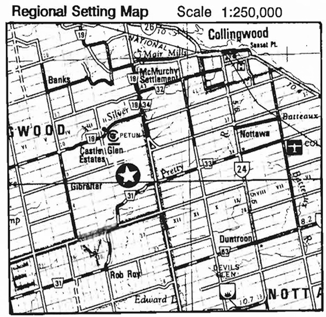
A total of 801 hectares (1979 acres) have been acquired and regulated under the Provincial Parks Act as part of Pretty River Valley Provincial Park, a proposed "natural environment" class park. As shown In Figure 1, the proposed park boundary Includes part or all of Lots 3 to 7, Concession 3, Lots 2 to 6, Concession 2, and Lots 1 to 6, Concession 3, Township of Collingwood, County of Grey. The park is located within the area of the Niagara Escarpment Plan and has been allocated among three land use designations: Escarpment Protection Area, Escarpment Natural Area and Escarpment Rural Area. This is a "nodal" park and is also classified as a "natural environment" park In the Niagara Escarpment Parks and Open Space System.
In 1994, the following agricultural land use permits were Issued on a total of approximately 107 hectares (265 acres) of park managed properties:
- Part of North Half Lot 3, Concession 1 (livestock grazing and hay cutting)
- Part Lots 1 and 2, Concession3 (hay cutting)
- Part of South Half Lot 2, Concession 2 (livestock grazing)
- Part Lots 5 and 6, Concession 3 (crop growing)
Guidelines:
The agricultural land use permits may be phased out upon completion of an approved park management plan.
Agricultural activities will be monitored by Ministry staff to determine that there are no adverse effects on natural values in the park. Negative Impacts may provide cause to revoke a land use permit.
A suitable buffer zone should be established around sensitive and significant natural features when delineating the areas under permit.
II. Land acquisition and disposal
Acquired Crown lands totalling approximately 190 hectares (470 acres) have yet to be regulated as part of the park.
Lands targeted for acquisition within the proposed park boundary, and adjacent lands proposed for conservation easement agreements, are identified in Figure 1. Various Township of Collingwood road allowances located within the proposed park boundary are also targeted for acquisition.
Proposed realignment and/or widening of County Road 31 through the provincial park may require the deregulation and disposition of (yet to be determined) park lands to the County of Grey.
Figure 1: Proposed park boundary and land status
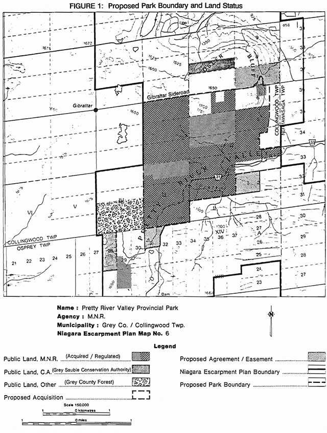
Enlarge figure 1 proposed park boundary and land status
Guidelines:
Additional lands and municipal road allowances within the proposed park boundary may be acquired on a willing seller - willing buyer basis, subject to the availability of funding through the Niagara Escarpment Land Acquisition and Stewardship Program or other sources. Proposed conservation easements may be negotiated with adjacent landowners.
Acquired Crown lands within the proposed park boundary will be regulated under the Provincial Parks Act.
Provided park natural values are not placed at risk, certain park lands may be deregulated and disposed of (by sale or land exchange) to the County of Grey for the proposed realignment of County Road 31.
III. Existing and proposed development
Existing development consists of: a small parking area south of County Road 31 (east part of Lot 3, Concession 1) and a snowmobile trail maintained seasonally by the Blue Mountain Snowdrifters snowmobile club; the Bruce Trail, maintained by the Blue Mountains Bruce Trail Club; and a system of signs, gates and fencing to control unauthorized entry Into the park. The Bruce Trail Osler shelter was demolished In 1994 with no plans for reconstruction. A system of abandoned logging roads runs through the park.
Grey County Road 31 Is proposed to be realigned and/or widened. Should this project proceed there could be significant environmental Impacts on local natural features.
The installation of interpretive stations would enhance user awareness of park management Issues and sensitive natural features.
Guidelines:
Trails and related facilities will continue to be maintained by the Blue Mountains Bruce Trail Club and the Blue Mountain Snowdrifters snowmobile club. Subject to trail Implementation planning, trail realignments and related development may be undertaken to avoid sensitive natural features or establish optimum trail routes.
The Ministry will monitor, review and provide Input Into the County’s proposed plan to realign and/or widen County Road 31.
Interpretive stations may be developed and erected at appropriate locations, as determined by a natural heritage Implementation plan.
Aside from the foregoing, no other development is proposed. Park sponsored projects will be subject to the availability of funding.
Figure 2: Organized Trails
Pretty River Valley Provincial Park

Enlarge figure 2 organized trails map
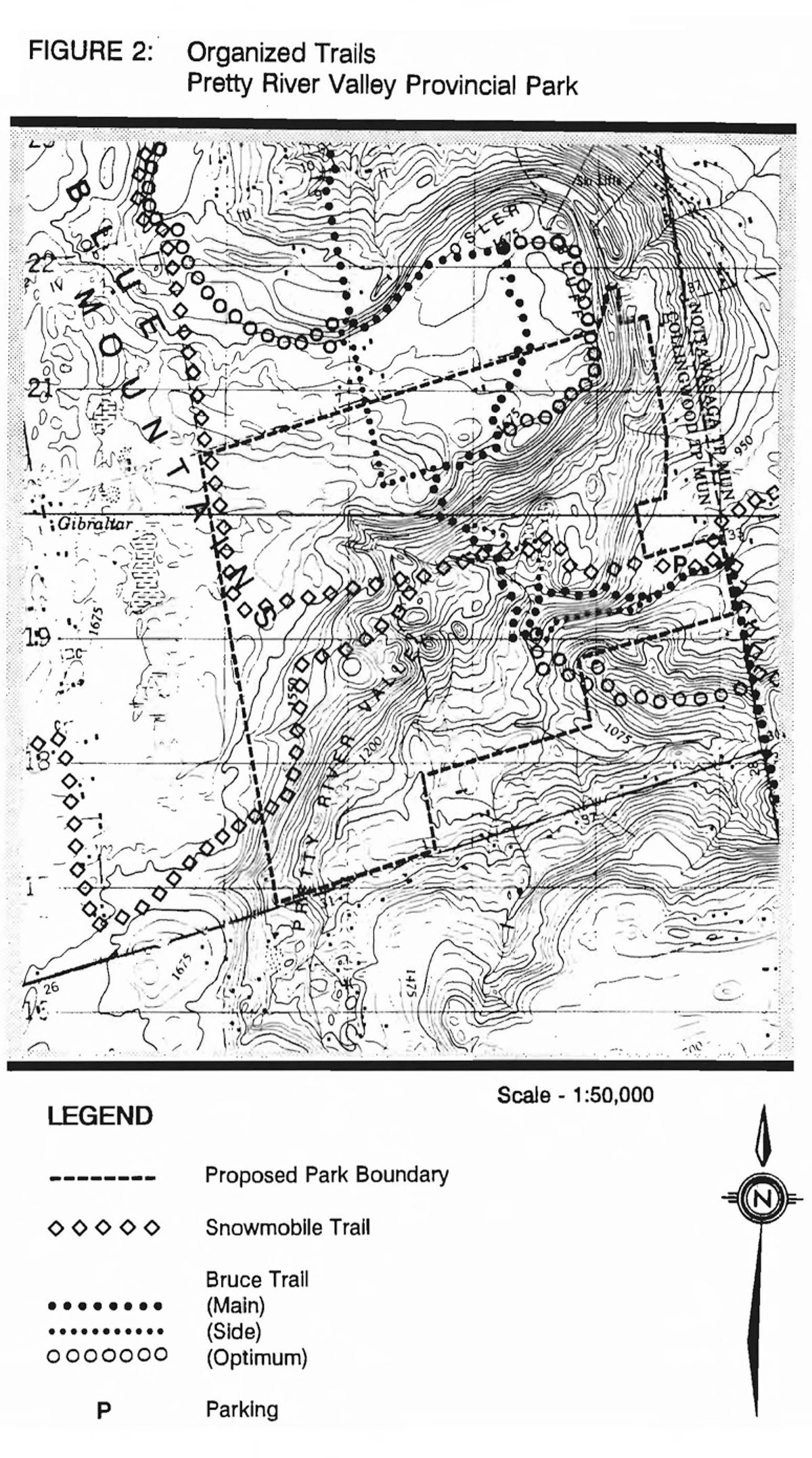
IV. Recreation activities
Hiking, cross-country skiing, mountain biking, snowmobiling, snowshoeing, picnicking, horseback riding and nature appreciation are recreational activities currently permitted. Hunting for small game, upland game birds and deer is permitted within season under Regulation 502, R.R.O., 1990, Schedule 2, of the Game and Fish Act (Wildlife Management Unit 82). Use of hunting dogs Is not permitted. There are conflicts between some user groups (e.g., hikers and mountain bikers, hikers and hunters).
Spawning rainbow trout are easy prey to fishermen, or poachers, due to the large numbers of fish in the shallow waters of the Pretty River during opening weekend of the trout fishing season. Establishment of a provincial fish sanctuary inside and outside the park boundaries is under consideration. The park was closed to fishing during opening weekend in 1994 under clause 32.(1)(e) of the Regulation 952, R.R.O., 1990, made under the Provincial Parks Act. High numbers of fishermen have also had a negative Impact on stream banks.
Camping (except by Bruce Trail hikers), rock climbing and off-road vehicular travel are not permitted In the park. The latter activity has caused considerable rutting and erosion to park trails and roads.
Guidelines:
Where possible, conflicts between user groups will be mitigated.
Hunting will be reviewed during preparation of a park management plan. In the interim, options under consideration to ensure public safety and the health of local wildlife populations Include controlled hunter numbers, no-hunting zones, restrictions on tree blinds, and/or replacing the high-powered rifle hunt with a shotgun/archery/black powder hunt.
Fishing may be closed in the park as necessary to protect spawning rainbow trout. Should the need arise, as determined by appropriate levels of research and monitoring, a regulated provincial fish sanctuary may be established In the area which will close the fishing season from the last Saturday In April until the end of May. This will be done in consultation with local game and fish clubs and local residents.
Efforts to prevent the unauthorized access of off-road vehicles Into the park will be continued.
V. Commercial activities
Trapping and bait fishing have occurred In the park. No other commercial activities are permitted. Forestry operations have been discontinued since the acquisition of Grey County forest lands inside the proposed park boundary.
Guideline:
Trapping and bait fishing will be phased out following local notification.
VI. Natural resources
Life science:
The provincial park occupies a substantial portion of the provincially significant Pretty River Valley West Life Science Area of Natural and Scientific Interest. A total of 416 flora species have been Identified In the park area, Including six provincially rare and 24 regionally rare plants. The habitats of rare plant species, In particular the talus slope, sugar maple forest, emerging groundwater and 'Y' gorge, are sensitive to human activity. The Pretty River sustains a significant coldwater trout habitat. No rare fauna have been found in this area. A reconnaissance life science survey has been undertaken for the area (S. Reznicek, 1983).
Earth science
The Pretty River Valley Earth Science Area of Natural and Scientific Interest contains provincially significant geological features related to glacial and post glacial processes along the highest point of the Niagara Escarpment. An earth science inventory and evaluation for the park has been completed (P. Kor, 1992).
Guideline:
A detailed life science Inventory may be undertaken prior to preparation of a park management plan.
Activities which Impact negatively on park natural values may be restricted or prohibited.
VII. Cultural resources
Numerous groups of native peoples have lived and/or hunted In the Pretty River Valley, although little is actually known about pre-history of the park area. French missionaries were the earliest Europeans to reach the area. In the mid-1800's, settlers started to arrive in the valley.
Guideline:
Both archaeological and historical surveys are needed to further document the cultural values of the park area. These surveys should be completed prior to preparation of a park management plan.
VIII. Natural heritage education
Existing facilities consist solely of signs identifying the provincial park boundary. A fact sheet providing basic Information about the park is available upon request.
Interpretative programming would Increase user awareness of park management Issues and sensitive natural features.
Guidelines:
The fact sheet will be updated and reproduced as required. Self-serve Interpretative programming may be provided.
IX. Marketing guideline:
This provincial park will not be promoted aside from general Information provided In the fact sheet and as Identified In Information presented to the public regarding the Niagara Escarpment Parks and Open Space System and the Bruce Trail Reference. A marketing plan will not be required.
X. Research guideline:
Appropriate research or Inventory projects will be encouraged, particularly In subject areas required to assist In preparation of a park management plan and to assist In Identifying and protecting sensitive natural features or cultural resources In the park.
XI. References
Barnard, C.S. Adaptation of the Recreation Opportunity Spectrum (ROS) For Its Application In Canadian Provincial Parks. (Thesis), University of Waterloo, Department of Recreation, Waterloo, 1985.
Bruce Trail Association. Bryce Trail Reference, 19th Edition. Hamilton, 1994.
Cottrill, G. Management/Operating Plan for the Pretty River Valley. Ontario Ministry of Natural Resources, Owen Sound District, Owen Sound, 1978.
Cuddy, D.G. Environmental Planning Series 7.2. Niagara Escarpment Planning Study. Duncan Crevice Caves Life Science Inventory Checklist. Ontario Ministry of Natural Resources, Park Planning Branch, Toronto, 1976.
Gosselin, L., McKibbon, G., Salvatori, F., Tucker, H., and Wells, D. Pretty River Valley Viewshed Analysis: Counties of Grey and Simcoe. Townships of Collingwood. Osprey and Nottawasaga. Niagara Escarpment Commission, Georgetown, Ontario, 1985.
Kor, P. Blue Mountain Area Moraines Area of Natural and Scientific Interest. Niagara Escarpment Inventory Project – Earth Science Checksheet. Ontario Ministry of Natural Resources, Southern Region, Aurora, 1992.
Kor, P. Earth Science Inventory and Evaluation of the Pretty River valley Provincial Park and Banks Moraine. Gibraltar Moraine and Pretty River Valley Area of Natural and Scientific Interest. Ontario Ministry of Natural Resources, Southern Region, Aurora,1992.
Lipton, G., Kershaw, B., and Emond. G. Resource Inventory Report of the Geology. Geomorphology. and Biology of the Pretty River Valley Proposed Park Area. Collingwood Township. Grey County. Ontario. Ontario Ministry of Natural Resources, Owen Sound District, Owen Sound, 1974.
Niagara Escarpment Commission. Niagara Escarpment Plan. Ontario Ministry of Environment and Energy, Toronto, 1994.
Ontario Ministry of Natural Resources. Ontario Provincial Parks Management Planning Manual. Provincial Operations Branch, Peterborough, 1994.
Ontario Ministry of Natural Resources. ,Ontario Provincial Parks: Planning and Management Policies. 1992 Update. Provincial Parks and Natural Heritage Policy Branch, Toronto, 1992.
Ontario Ministry of Natural Resources. Owen Sound District Land Use Guidelines. Owen Sound District, Owen Sound, 1983.
Cottrill, G. Pretty River Valley Provincial Park Background Information Report. Ontario Ministry of Natural Resources, Owen Sound District, 1986.
Payne, R.J., Barnard, c., Dance, J., Telfer, S., and Wright, J. The Pretty River Valley Report: An Assessment of the Recreation Opportunities In the Pretty River Valley. University of Waterloo, Department of Recreation, Waterloo, 1983.
Reznicek, S. Life Science Survey for the Pretty River Valley Park Reserve. Grey County. Ontario. Ontario Ministry of Natural Resources, Owen Sound District, Owen Sound, 1983.
Woerns, N. Pretty River Valley Special Area Earth Science Inventory Checklist. Ontario Ministry of Natural Resources, Parks Planning Branch, Toronto, 1977.