Pretty River Valley Provincial Park Management Statement: Amendment
This amendment provides revised direction in the statement to restore or naturalize disturbed lands, including lands previously used for agriculture, in order to enhance ecological integrity.
Examination and adjustment of management direction
| Approval Date | Examination or Type of Adjustment | Examination Outcome (where applicable) | Comment |
|---|---|---|---|
| April 24, 1995 | Management Plan | N/A | Interim Management Statement signed by Norm Richards |
| February 24, 2016 | Administrative Update | N/A | Update existing Management Direction to reflect current legislation and policy. |
| May 4, 2016 | Amendment | N/A | Amend existing management direction to enable restoration (in progress). |
Amendment approval statement
Dear Sir or Madam:
I am pleased to approve this amendment to the management plan for Pretty River Valley Provincial Park. The amendment provides revised direction in the plan to restore or naturalize disturbed lands, including lands previously used for agriculture, in order to enhance ecological integrity.
I would like to express my appreciation to all those who participated in the planning process.
Sincerely,
Signed by Bruce Bateman
Director, Ontario Parks
Date May 2, 2017
Approval statement
April 24, 1995
Regional Director’s approval statement
This Interim Management Statement will provide interim direction for the management of Pretty River Valley Provincial Park until such time as a comprehensive Park Management Plan is prepared.
This statement will provide the basis for the subsequent preparation of the Park Management Plan.
I am pleased to approve the Pretty River Valley Provincial Park Interim Management Statement.
Signed by Norm Richards
Manager,
Parks Ontario
Background information
Name: Pretty River Valley Provincial Park
Class: Natural Environment
MNRF Parks Zone: Southwest
MNRF Region: Southern
Total Area: 808 ha (regulated)
Ecodistrict: 6E – 41
Regulation: Ont. Reg. 45/85 targets
1. Life science representation (provincial significance)
| Site Type/Landscape Unit | Feature |
|---|---|
| Escarpment Complex | Escarpment crevice cave vegetation, rim and talus slope forests. |
2. Earth science representation (provincial significance)
| Geological Theme | Feature |
|---|---|
| Quaternary, Upper Ordivician, Lower-Middle Silurian | Crevice caves, talus slopes, ice-contact terrain |
3. Cultural resources representation
| Theme | Segment |
|---|---|
| Post contact tribes and bands. Early settlements. | Settlement of Grey County |
4. Recreational opportunities
| Day Use | Car Camping | Back Country |
|---|---|---|
| Hiking (Bruce Trail Snowmobiling Cross-Country Skiing Snowshoeing Hunting Fishing Mountain Biking Picnicking Horseback Riding Nature Appreciation | n/a | Bruce Trail hiker camping |
Inventories
| Level/Type | Earth Science | Life Science | Cultural | Recreational | Other |
|---|---|---|---|---|---|
| Check Sheet | Woerns, 1977 Kor, 1992 | Cuddy, 1976 | - | - | - |
| Reconnaissance | Lipton, Kershaw & Emond, 1974 | Reznicek, 1983 | Required | Barnard, 1985 | Management/ Operating plan, 1978 |
| Detailed | Kor, 1992 | Required | - | University of Waterloo, 1983 | Background information Report, 1986 Viewshed analysis, 1985 |
Figure 1: Regional setting map
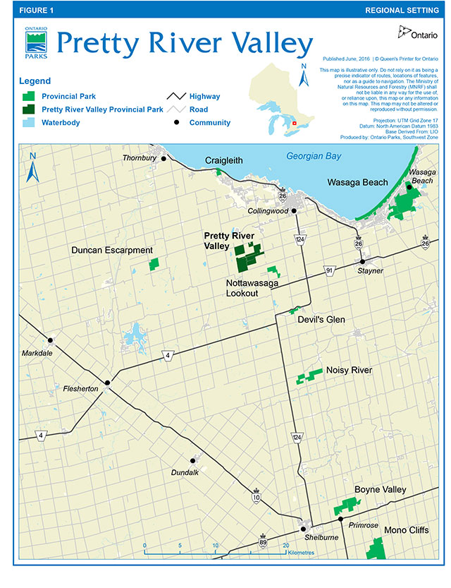
Enlarge figure 1: Regional setting map
Figure 2: Park boundary and existing development map
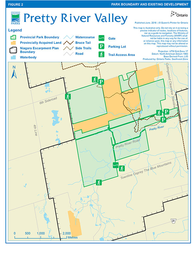
Enlarge figure 2: Park boundary and existing development ma
Context
1. Provincial Parks and Conservation Reserves Act
The Provincial Parks and Conservation Reserves Act, 2006 (PPCRA) requires that a Management Direction is approved for each protected area in Ontario. This document fulfils this requirement, and provides direction for managing the provincial park.
The PPCRA has two principles that guide all aspects of planning and management of Ontario’s system of provincial parks and conservation reserves:
- Maintenance of ecological integrity shall be the first priority and the restoration of ecological integrity shall be considered.
- Opportunities for consultation shall be provided. 2006, c. 12, s. 3.
The PPCRA also outlines four objectives for establishing and managing provincial parks:
- To permanently protect representative ecosystems, biodiversity and provincially significant elements of Ontario’s natural and cultural heritage and to manage these areas to ensure that ecological integrity is maintained.
- To provide opportunities for ecologically sustainable recreation opportunities and encourage associated economic benefits.
- To provide opportunities for residents of Ontario and visitors to increase their knowledge and appreciation of Ontario’s natural and cultural heritage.
- To facilitate scientific research and to provide points of reference to support monitoring of ecological change on the broader landscape. 2006, c. 12, s. 2 (1).
2. Management context
Management of this park will be consistent with all relevant legislation and provincial policies, including the four provincial park objectives and guiding principles of the PPCRA. Management of the park will also be consistent with the Endangered Species Act, 2007 (ESA), including the protection of Species at Risk.
The implementation of projects in this provincial park will comply with the requirements of A Class Environmental Assessment for Provincial Parks and Conservation Reserves (Class EA-PPCR). This may include further opportunities for consultation, as required.
Pretty River Valley Provincial Park encompasses a portion of the Niagara Escarpment and is therefore within the Niagara Escarpment Plan Area. The park contributes to the Niagara Escarpment Parks and Open Space System (NEPOSS)
Management guidelines
Land tenure
A total of 808 hectares (1996 acres) have been acquired and regulated under the Provincial Parks and Conservation Reserves Act as Pretty River Valley Provincial Park, a natural environment class park (Figure 1). As shown in Figure 2, the park boundary includes part or all of Lots 3 to 6, Concession 1, Lots 2 to 6, Concession 2, and Lots 1 to 6, Concession 3, Township of Collingwood, County of Grey.
In 1994, the following agricultural land use permits were issued on a total of approximately 107 hectares (265 acres) of park managed properties:
- Part of North Half Lot 3, Concession 1 (livestock grazing and hay cutting)
- Part Lots 1 and 2, Concession 3 (hay cutting)
- Part of South Half Lot 2, Concession 2 (livestock grazing)
- Part Lots 5 and 6, Concession 3 (crop growing)
Guidelines:
Agricultural land use permits have been phased out in accordance with park policy.
Land acquisition and disposal
Acquired Crown lands totalling approximately 190 hectares (470 acres) have yet to be regulated as part of the park proposed realignment and/or widening of County Road 31 through the provincial park may require the deregulation and disposition of (yet to be determined) park lands to the County of Grey.
Guidelines:
Ontario Parks will support, in principle, the acquisition of property for addition to Pretty River Valley Provincial Park, if the acquisition will enhance the values or management of the park. Acquisition or securement will be subject to funding and willingness of the owners to sell or lease their properties or enter into a conservation easement. Land securement priorities for Pretty River Valley Provincial Park are focused on lands adjacent and with similar natural and cultural values.
Acquired Crown lands within the proposed park boundary will be regulated under the Provincial Parks and Conservation Reserves Act.
Provided park natural values are not placed at risk, certain park lands may be deregulated and disposed of (by sale or land exchange) to the County of Grey for the proposed realignment of County Road 31.
Existing and proposed development
Existing development consists of: parking areas and a snowmobile trail maintained seasonally by the Blue Mountain Snowdrifters snowmobile club; the Bruce Trail, maintained by the Blue Mountains Bruce Trail Club; and a system of signs, gates and fencing to control unauthorized entry into the park. The Bruce Trail Osier shelter was demolished in 1994 with no plans for reconstruction. A system of abandoned logging roads runs through the park.
Grey County Road 31 is proposed to be realigned and/or widened. Should this project proceed there could be significant environmental impacts on local natural features.
The installation of interpretive stations would enhance user awareness of park management issues and sensitive natural features.
Guidelines:
Trails and related facilities will continue to be maintained by the Blue Mountains Bruce Trail Club and the Blue Mountain Snowdrifters snowmobile club. Subject to trail implementation planning, trail realignments and related development may be undertaken to avoid sensitive natural features or establish optimum trail routes.
The MNRF, Ontario Parks will monitor, review and provide input into Grey County’s proposed plan to realign and/or widen County Road 31.
Interpretive stations may be developed and erected at appropriate locations, as determined by a natural heritage implementation plan.
No other development is proposed. Park sponsored projects will be subject to the availability of funding.
Ecologically sustainable recreation activities
Hiking, cross-country skiing, mountain biking, snowmobiling, snowshoeing, picnicking, horseback riding and nature appreciation are recreational activities currently permitted. Hunting for small game, upland game birds and deer is permitted within season under the Fish and Wildlife Conservation Act. Use of hunting dogs is not permitted. There are conflicts between some user groups (e.g., hikers and mountain bikers, hikers and hunters).
Spawning rainbow trout are easy prey to fishermen, or poachers, due to the large numbers of fish in the shallow waters of the Pretty River during opening weekend of the trout fishing season. A provincial fish sanctuary has been established inside and outside the park. Fishing is not permitted in the Pretty River from the fourth Saturday in April to May 31st, in accordance with the regulations for Fisheries Management Zone 16 under the Fish and Wildlife Conservation Act. High numbers of fishermen have also had a negative impact on stream banks.
Camping (except by Bruce Trail hikers), rock climbing and off-road vehicular travel are not permitted in the park. The latter activity has caused considerable rutting and erosion to park trails and roads.
Guidelines:
Where possible, conflicts between user groups will be mitigated.
Hunting will be reviewed during preparation of a park management plan. In the interim, options under consideration to ensure public safety and the health of local wildlife populations include controlled hunter numbers, no-hunting zones, restrictions on tree blinds, and/or replacing the high-powered rifle hunt with a shotgun/archery/black powder hunt.
Fishing may be closed in the park as necessary to protect spawning rainbow trout. A regulated provincial fish sanctuary has been established in the area which has closed the fishing season from the fourth Saturday in April until the end of May.
Efforts to prevent the unauthorized access of off-road vehicles into the park will be continued.
Commercial activities
Trapping and bait fishing have occurred in the park, but are not compatible with a natural environment classification. Commercial activities are not permitted. Forestry operations have been discontinued since the acquisition of Grey County forest lands inside the proposed park boundary.
Guideline:
Trapping and bait fishing are not permitted within the park.
Natural resource management
Life Science - The provincial park occupies a substantial portion of the provincially significant Pretty River Valley West Life Science Area of Natural and Scientific Interest. A total of 416 flora species have been identified in the park area, including six provincially rare and 24 regionally rare plants as well as species at risk. The habitats of rare plant species, in particular the talus slope, sugar maple forest, emerging groundwater and 'Y' gorge, are sensitive to human activity. The Pretty River sustains a significant coldwater trout habitat. No rare fauna have been found in this area. A reconnaissance life science survey has been undertaken for the area (S. Reznicek, 1983).
Earth Science - The Pretty River Valley Earth Science Area of Natural and Scientific Interest contains provincially significant geological features related to glacial and postglacial processes along the highest point of the Niagara Escarpment. An earth science inventory and evaluation for the park has been completed (P. Kor, 1992).
Guideline:
A detailed life science inventory may be undertaken prior to preparation of a park management plan.
Activities which impact negatively on park natural values may be restricted or prohibited.
Disturbed lands including those currently or formerly in agricultural use will be restored or naturalized. The primary goal of restoration and naturalization will be to enhance the park’s ecological integrity by accelerating succession from disturbed areas such as agriculture or old field to locally representative vegetation types, while minimizing colonization of noxious weeds or alien invasive species. Restoration and naturalization approaches could include passive or indirect restoration, seeding and planting, wetland improvement, progressive retirement and invasive species control. Site specific restoration and naturalization activities will be determined based on current site conditions, available resources, funding and partnership opportunities, and will be subject to evaluation under the Class EA-PPCR.
Cultural resources
Numerous groups of native peoples have lived and/or hunted in the Pretty River Valley, although little is actually known about pre-history of the park area. French missionaries were the earliest Europeans to reach the area. In the mid-1800's, settlers started to arrive in the valley.
Guideline:
Both archaeological and historical surveys are needed to further document the cultural values of the park area. These surveys should be completed prior to preparation of a park management plan.
Cultural heritage resources that may be impacted by any park projects and activities shall be identified and managed (i.e., protected, maintained, used and disposed of) in accordance with the Standards and Guidelines for Conservation of Provincial Heritage Properties (Ontario Heritage Act). Staff will also consult MNRF's Technical Guideline for Cultural Heritage Resources for Projects Planned Under the Class Environmental Assessment for Resource Stewardship and Facility Development and the Class Environmental Assessment for Provincial Parks and Conservation Reserves (2006).
Natural heritage education
Existing facilities consist solely of signs identifying the provincial park boundary. A fact sheet providing basic information about the park is available upon request. Interpretative programming would increase user awareness of park management issues and sensitive natural features.
Guidelines:
The fact sheet will be updated and reproduced as required.
Self-serve interpretative programming may be provided.
Marketing
Guideline:
This provincial park will not be promoted aside from general information provided in the fact sheet and as identified in information presented to the public regarding the NEPOSS and the Bruce Trail Reference. A marketing plan will not be required.
Marketing for Pretty River Valley Provincial Park will occur through Ontario Parks' corporate marketing strategies and activities.
Research
Research activities require authorization issued under the PPCRA, consistent with research authorization policies for Provincial Parks and Conservation Reserves. Research is subject to development and management policies associated with the park’s classification, unless special permission is given. Research must meet all requirements under applicable provincial and federal legislation, and may require additional permits or approval (e.g., MNRF Wildlife Scientific Collector authorization or ESA permits).
Guideline:
Appropriate research or inventory projects will be encouraged, particularly in subject areas required to assist in preparation of a park management plan and to assist in identifying and protecting sensitive natural features or cultural resources in the park.
References
Barnard, C.S. Adaptation of the Recreation Opportunity Spectrum (ROS) For Its Application In Canadian Provincial Parks. (Thesis), University of Waterloo, Department of Recreation, Waterloo, 1985.
Bruce Trail Association. Bruce Trail Reference, 19th Edition. Hamilton, 1994.
Cottrill, G. Management/Operating Plan for the Pretty River Valley. Ontario Ministry of Natural Resources, Owen Sound District, Owen Sound, 1978.
Cuddy, D.G. Environmental Planning Series 7.2. Niagara Escarpment Planning Study, Duncan Crevice Caves Life Science Inventory Checklist. Ontario Ministry of Natural Resources, Park Planning Branch, Toronto, 1976.
Gosselin, L., McKibbon, G., Salvatori, F., Tucker, H., and Wells, D. Pretty River Valley Viewshed Analysis: Counties of Grey and Simcoe. Townships of Collingwood. Osprey and Nottawasaga. Niagara Escarpment Commission, Georgetown, Ontario, 1985.
Kor, P. Blue Mountain Area Moraines Area of Natural and Scientific Interest. Niagara Escarpment Inventory Project - Earth Science Checksheet. Ontario Ministry of Natural Resources, Southern Region, Aurora, 1992.
Kor, P. Earth Science Inventory and Evaluation of the Pretty River Valley Provincial Park and Banks Moraine. Gibraltar Moraine and Pretty River Valley Area of Natural and Scientific Interest. Ontario Ministry of Natural Resources, Southern Region, Aurora, 1992.
Lipton, G., Kershaw, B., and Emond. G. Resource Inventory Report of the Geology. Geomorphology. and Biology of the Pretty River Valley Proposed Park Area. Collingwood Township. Grey County. Ontario. Ontario Ministry of Natural Resources, Owen Sound District, Owen Sound, 1974.
Niagara Escarpment Commission. Niagara Escarpment Plan. Ontario Ministry of Environment and Energy, Toronto, 1994.
Ontario Ministry of Natural Resources. 2006. A Technical Guideline for Cultural Heritage Resources for Projects Planned Under the Class Environmental Assessment for MNR Resource Stewardship and Facility Development Projects and the Class Environmental Assessment for Provincial Parks and Conservation Reserves.
Ontario Ministry of Natural Resources. 2010. Species at Risk in Ontario List.
Ontario Ministry of Natural Resources. 2011. Ontario’s Crown Land Use Policy Atlas.
Ontario Ministry of Natural Resources. 2011. Our Sustainable Future: A Renewed Call to Action – Ministry of Natural Resources Strategic Directions. Peterborough.
Ontario Ministry of Natural Resources. 2012. Biodiversity: It’s In Our Nature. Ontario Government Plan to Conserve Biodiversity, 2012-2020. Queen’s Printer for Ontario. Toronto, ON. 42 pp.
Ontario Ministry of Natural Resources. 2014. Ontario Protected Areas Planning Manual: 2014 Edition. Peterborough. Queens Printer for Ontario. 33pp.
Ontario Ministry of Natural Resources. A Class Environmental Assessment for Provincial Parks and Conservation Reserves, 2005.
Ontario Ministry of Natural Resources. Ontario Provincial Parks Management Planning Manual. Provincial Operations Branch, Peterborough, 1994.
Ontario Ministry of Natural Resources. Ontario Provincial Parks: Planning and Management Policies. 1992 Update. Provincial Parks and Natural Heritage Policy Branch, Toronto, 1992.
Ontario Ministry of Natural Resources. Owen Sound District Land Use Guidelines. Owen Sound District, Owen Sound, 1983.
Cottrill, G. Pretty River Valley Provincial Park Background Information Report. Ontario Ministry of Natural Resources, Owen Sound District, 1986.
Payne, R.J., Barnard, C., Dance, J., Telfer, S., and Wright, J. The Pretty River Valley Report: An Assessment of the Recreation Opportunities In the Pretty River Valley. University of Waterloo, Department of Recreation, Waterloo, 1983.
Reznicek, S. Life Science Survey for the Pretty River Valley Park Reserve, Grey County, Ontario. Ontario Ministry of Natural Resources, Owen Sound District, Owen Sound, 1983.
Woerns, N. Pretty River Valley Special Area Earth Science Inventory Checklist. Ontario Ministry of Natural Resources, Parks Planning Branch, Toronto, 1977.
Footnotes
- footnote[1] Back to paragraph Species at risk are defined as those species listed on the Species at Risk in Ontario (SARO) List regulation. In addition, Ontario Parks manages protected areas for the benefit of provincially significant species (S1-S3) as defined by Ontario’s Natural Heritage Information Centre (NHIC).
- footnote[2] Back to paragraph The NEPOSS protects the significant, natural and cultural features along the Escarpment, and provides for recreation and appreciation of the features. The NEPOSS presently consists of over 100 parks and open spaces owned and managed by a variety of agencies
- footnote[3] Back to paragraph The designation of Biosphere Reserve recognizes the natural features and ecological importance of the Escarpment.