Pukaskwa River Park Management Statement (2006 – Amended 2019)
This document provides policy direction for the protection, development and management of Pukaskwa River Provincial Park and its resources.
Amendment approval statement
August 28, 2019
Dear Sir or Madam:
I am pleased to approve this amendment to the management statement for Pukaskwa River Provincial Park. The amendment provides revised direction in the management statement for the issuance of commercial tenure and conditions of any disposition, including requirements under the Provincial Parks and Conservation Reserves Act, 2006 and approval through an environmental assessment process.
I would like to express my appreciation to those who participated in the planning process.
Sincerely,
Jason Travers, Director
Ontario Parks
Approval statement
December 5, 2006
I am pleased to approve this Interim Management Statement for Pukaskwa River Provincial Park. Ontario’s Living Legacy Land Use Strategy (OMNR 1999) designated this area as a waterway park. This park was regulated under the Provincial Parks Act (O. Reg. 311/02) in November 2002.
This Interim Management Statement provides direction for the protection and custodial management of Pukaskwa River Provincial Park.
Paul Bewick
Zone Manager
Northeast Zone
Ontario Parks
1.0 Introduction
Pukaskwa River Provincial Park was designated in Ontario’s Living Legacy Land Use Strategy (OMNR 1999). This park was regulated under the Provincial Parks Act in December of 2002 (O. Reg. 311/02). The park begins at Gibson Lake, approximately 25 kilometres south of the Town of White River and 55 kilometres northwest of the Town of Wawa (Figure 1). This provincial park protects approximately 22 kilometres of the Pukaskwa River including lakes in the headwaters (Figure 2). Pukaskwa National Park, which is directly adjacent, protects the remaining 55 kilometres of the Pukaskwa River as it flows into Lake Superior.
Pukaskwa River Provincial Park is classed as a waterway. Waterway parks protect outstanding recreational water routes and are meant to provide high quality recreational and educational experiences.
1.1 Objectives
Pukaskwa River Provincial Park will be managed consistent with the four objectives for provincial parks:
Protection: To protect provincially significant elements of the natural and cultural landscapes of Ontario.
Recreation: To provide provincial park outdoor recreation opportunities ranging from high intensity day-use to low-intensity wilderness experiences.
Heritage Appreciation: To provide opportunities for exploration and appreciation of the outdoor natural and cultural heritage of Ontario.
Tourism: To provide Ontario’s residents and out-of-province visitors with opportunities to discover and experience the distinctive regions of the Province.
2.0 Management context
The purpose of this Interim Management Statement (IMS) is to provide direction to ensure custodial management of park resources. Future park planning may be undertaken as required to provide direction on significant decisions regarding resource stewardship, development, operations and permitted uses with full public and aboriginal consultation.
Park management will follow direction from:
- Provincial Parks Act (1990) and regulations
- Ontario Provincial Parks Planning and Management Policies (OMNR 1992)
- Crown Land Use Policy Atlas (OMNR 2004a)
- Ontario’s Living Legacy Land Use Strategy and policy clarifications (OMNR 2000), amendments, and related direction.
In addressing custodial management obligations to protect park values and ensure public health and safety, Ontario Parks will ensure that policy and Environmental Assessment Act (1990) requirements are implemented.
2.1 Environmental Assessment
As part of the Ontario Ministry of Natural Resources (MNR), Ontario Parks is a public sector agency that is subject to the Environmental Assessment Act. Park management will be carried out in accordance with legislation, policies and guidelines that are required under MNR’s A Class Environmental Assessment for Provincial Parks and Conservation Reserves (OMNR 2005a).
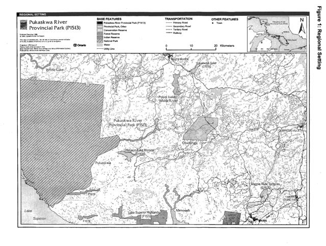
Enlarge this map of the regional setting of Pukaskwa River Provincial Park
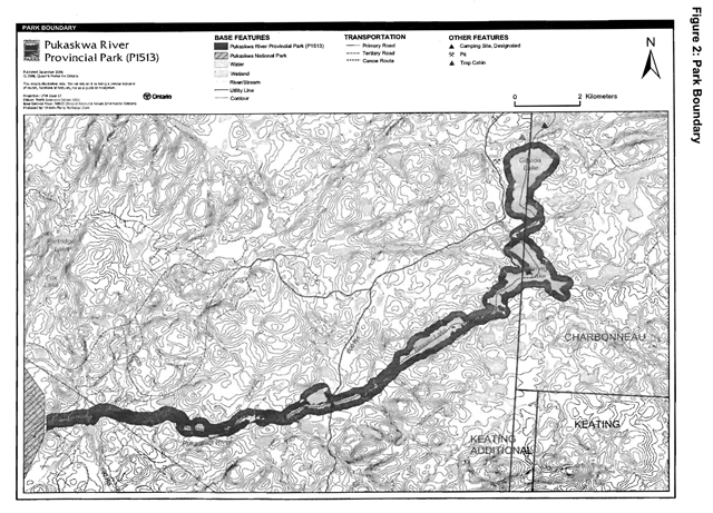
Enlarge this map of the park boundary of Pukaskwa River Provincial Park
3.0 Park features and values
Pukaskwa River is a 1,370 hectare waterway class park which flows predominately south through Ecodistrict 3E-5 into 3E-4. The bedrock underlying the site is a granitic country rock of the Superior Province. The waterway exhibits a variety of river conditions including lake, small river, and some small wetland sections linked along bedrock controlled channels over strongly broken shallow sandy till rock uplands and lacustrine sand and gravel outwash deposits (Kershaw 2002). Pukaskwa River Provincial Park contains spectacular scenery and offers a remote white-water river experience for persons with advanced canoeing and camping skills.
The river was well known by Canadian paddling icon Bill Mason whose painting Campfire, Pukaskwa River
captures the beauty of this waterway. The river was also featured in Bill Mason’s films, including Waterwalker (1984).
3.1 Geological features
Bedrock of Pukaskwa River Provincial Park consists of an undifferentiated, foliated to gneissic, tonalite suite of intrusive rocks which is well exposed along the length of the river in shoreline outcrops and cliffs. Minor metasedimentary rocks are also exposed along the river’s length. These rocks lie in the Wawa Subprovince, Superior Province, Canadian Precambrian Shield (Kor 2003).
Very stony sandy till is exposed near the west end of the river, and likely forms a thin, discontinuous veneer over much of the bedrock of the region. Boulder lags commonly occur along the entire length of the river, and cue particularly well-developed in areas where the course of the river narrows, or is constricted by bedrock narrows. These large rounded boulders were erratics, and some are over a metre in size. The extent of these boulder lags suggests that the Pukaskwa River carried large volumes of meltwater flow in early postglacial time as the continental glacier melted, and these flows were much greater than today (Kor 2003).
3.2 Biological features
This river crosses from Ecodistrict 3E-5 to 3E-4. Most of the site occurs on strongly broken shallow sandy till upland, while a small portion of the lower section of the river occurs on a deeper lacustrine sand or gravel deposit. The park includes headwaters of a small cold-water river, which is flanked by small riparian wetlands and shrub thickets. Flow volume in the river can be quite low late in the summer. The headwaters within the park include two coldwater lakes, Gibson Lake and Jarvey Lake (Morris 2002).
Forests included in the park are representative of Ecoregion 3E (Morris 2003). The majority of the stands are old-growth.
3.3 Cultural setting
An investigation into the cultural features specific to Pukaskwa River Provincial Park has not been completed at this time. Any future planning will be within the context of a provincial framework, A Topical Organization of Ontario History (OMNR 1974). In addition, updates and discussions with First Nations, other agencies and stakeholders may be carried out to identify cultural heritage values and features within the park and their significance. This information may be used to develop management guidelines to conserve and protect representative archaeological and historical values and features, or to provide direction for further research.
3.4 Recreation
Pukaskwa River is a remote, pristine, free-flowing, medium-sized shield river. The park is relatively inaccessible and as such offers an advanced wilderness recreation opportunity. It is unlikely that general recreation users will be attracted to the site - there are other comparable or more diverse rivers that are much more accessible in this area (e.g. White River).
The Pukaskwa River has an established canoe route. Persons travelling the Pukaskwa typically canoe all the way to Lake Superior where they either take out at Pukaskwa National Park or they continue east some 88 kilometres to get to Michipicoten Harbour and Wawa. The Pukaskwa River canoe route descriptions give options for access; from Highway 17 at Sagina Lake and from fly-in to Pokei or Gibson Lakes (Kershaw 2002). There are different lengths of trips depending on the access.
Four campsites are located within this park on the canoe route. There are additional campsites within Pukaskwa National Park, which is connected to this provincial park.
4.0 Aboriginal uses
Pukaskwa River Provincial Park lies within the Robinson-Superior Treaty (1850) area.
Discussions regarding the regulation of Pukaskwa River Provincial Park occurred with the local First Nations.
First Nations have expressed interest in and have shared knowledge of the park and surrounding area. Aboriginal communities have used the area for hunting, trapping, fishing, gathering and travel. These uses may continue, subject to public safety, conservation and other considerations.
Any communications and cooperation between Aboriginal communities and MNR for planning and operations purposes will be done without prejudice to any future discussions or negotiations between the government of Ontario and Aboriginal communities.
5.0 Stewardship policies
The removal, damage or defacing of Crown property, natural objects, relics and artefacts is not permitted in provincial parks (Provincial Parks Act).
Non-native species will not be deliberately introduced into the park. Where non-native species are already established and threaten park values (i.e. has become invasive), a strategy to control the species may be developed (OMNR 1992).
5.1 Terrestrial Ecosystems
5.1.1 Vegetation
Harvesting
Commercial forest operations are not permitted within the park (OMNR 2004a).
The harvest of non-timber forest products such as club moss, Canada yew etc., will not be permitted within the park.
Existing authorized wild rice harvesting may continue. New operations will not be permitted.
There are no fuelwood cutting permits currently issued for the park. No new permits will be issued (OMNR 2000).
Insects and disease
Insects and diseases may be managed where the aesthetic, cultural, and/or natural values of Pukaskwa River Provincial Park are threatened (OMNR 1992).
Controls will follow guidelines established by the Ontario Ministry of the Environment (MOE) and the MNR. Biological controls, in preference to chemicals, will be used whenever possible (OMNR 1992).
Fire
In accordance with existing provincial park policy and the Forest Fire Management Strategy for Ontario, forest fire protection will be carried out in the park as on surrounding lands (OMNR 2004b).
Whenever feasible, MNR’s Forest Fire Management program will use techniques which minimize damage to the landscape, such as limiting the use of heavy equipment or limiting the number of trees felled during response efforts (OMNR 2004b).
5.1.2 Wildlife management
Pukaskwa River Provincial Park is located within Wildlife Management Units 33. The removal or harassment of non-game animals is not permitted (Provincial Parks Act).
Hunting
Sport hunting is permitted to continue. Considerations of safety and conservation with respect to hunting may be made through future management planning, which would include public and Aboriginal consultation (OMNR 2000).
The Fish and Wildlife Conservation Act (1997) and the Migratory Birds Convention Act (1994) govern hunting within the park. The Ontario Hunting Regulations Summary contains regulations specific to this area. The harvest of bullfrogs and snapping turtles is illegal in provincial parks.
Bear management areas
The park includes portions of two licensed bear management areas BMAs: WA 33-003 and WA 33-004 (Figure 3).
Hunting, including commercial bear hunting, is permitted to continue in this park, but is subject to conditions identified during park management planning (i.e. the designation of nature reserve zones). No new BMA licences will be issued. Renewal and transfer of the existing licences will be addressed through management planning and will consider conservation principles and public safety (OMNR 2000; 2004a).
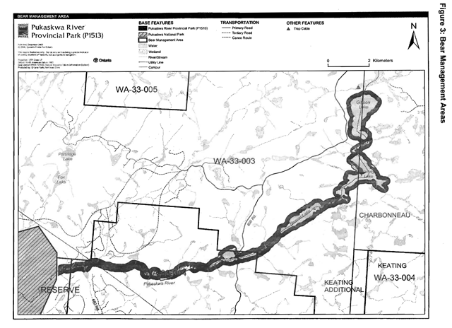
Enlarge this map of bear management areas within Pukaskwa River Provincial Park
Trapping
Portions of two licensed trap lines occur in the park: WA-37 and WA-51 (Figure 4).
Existing commercial fur harvesting operations may continue where the activity has been licensed or permitted since January 1, 1992. New operations, including trap cabins and trails, will not be permitted (OMNR 2000; 2003).
Transfers of active trap line licenses are permitted, subject to a review of potential impacts and the normal transfer or renewal conditions that apply.
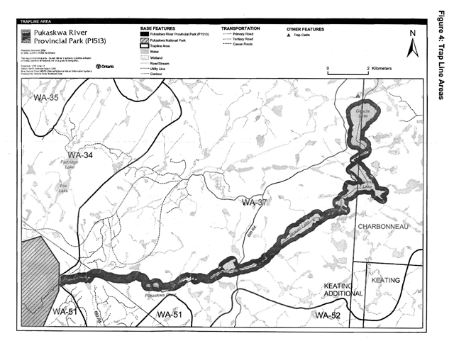
Enlarge this map of trap line areas within Pukaskwa River Provincial Park
5.1.3 Industrial resources
There are no existing mining claims within the park.
Mining and surface rights on all lands within the park have been withdrawn from staking under the Mining Act (1990). Mineral exploration and mineral extraction are not permitted in the park (OMNR 1992).
In accordance with Ontario’s Living Legacy Land Use Strategy, access in the park to mining lands (e.g. forest reserves and mining patents) will be permitted for purposes of mineral exploration, development or operations. Access will be planned in accordance with the requirements of the Environmental Assessment Act.
There are no licensed aggregate pits (active or inactive) located within Pukaskwa River Provincial Park. Aggregate extraction is not permitted (OMNR 1992).
5.1.4 Access and crossings
Access
This park is accessible via land, air, and water. Access to Pukaskwa River occurs from an adjacent forest access dirt road on the west side, a dirt road follows the hydro corridor right of way. Persons fly in by aircraft to Gibson Lake (Kershaw 2002).
The Pukaskwa River Canoe Route provides water access along the length of the park.
Roads
Road 600 travels north-south just west of Gibson Lake outside the park and crosses over the Pukaskwa River within park boundaries. The only portion of this road within park boundaries is located at the river crossing. This permanent primary road crossing will continue to be used (OMNR 1999).
A tertiary road follows the hydro line right of way. There is no crossing of the river associated with this road.
Road 680 approaches the park from the south, but does not reach the park.
Where existing forest access roads are essential for continued access beyond the park for forest management or recreation purposes, and alternative road access does not exist, or road relocation is not feasible, existing roads will continue to be available for access. Continued use will include maintenance and may include upgrading (OMNR 2004a). Ontario Parks is not responsible for maintenance or upgrading of any existing roads within the park boundary.
Any proposed development, maintenance or upgrading of existing roads must meet all requirements of the Environmental Assessment Act.
Aggregate resource extraction is not permitted within parks. An external source of aggregate is required for road improvements and maintenance.
Utility corridors
There is one crossing of the park by a Hydro One utility corridor. The crossing occurs in the unsurveyed territory just east of the boundary of this park where it connects with Pukaskwa National Park. This hydro corridor is managed through a province wide land use permit issued to Hydro One.
Maintenance of the existing utility lines will be permitted. Maintenance activities must adhere to the regulations set out under relevant acts, such as the Environmental Assessment Act, the Canadian Environmental Protection Act (1999), and the Pesticides Act (1990), and shall not negatively impact the values being protected within this park.
All public utilities (e.g. gas pipelines, transmission lines, communications towers, etc.) must avoid park lands wherever possible, however new utility corridor crossings may be necessary to maintain essential public services (OMNR 2004a).
Any future utility corridors proposed through the park, where park lands are unavoidable, will be reviewed on a case-by-case basis. Protection of park features and values will be priority and all requirements of the Environmental Assessment Act will be met.
Ontario Parks may provide tenure for a utility corridor to accommodate the development of the new East-West Tie electrical transmission line, subject to completion of an Environmental Assessment, approval by the Minister, and any conditions necessary to protect park values.
Recreational trails
Canoe route
Pukaskwa River has a canoe route. Low summer water flows, unmaintained portages, and remote and demanding skill levels limit travel along this river to those with more advance wilderness skills.
Snowmobile trails
There are currently no snowmobile trails within the park. New trails may be considered if the need arises. Any proposed development within the park is subject to Environmental Assessment Act requirements.
Other trails
There are currently no other authorized recreational trails within the park boundary. New hiking trails associated with the canoe route may be developed if the need can be justified through planning. Any proposed development within the park is subject to Environmental Assessment Act requirements.
5.1.5 Adjacent Land Management
Forestry
The land adjacent to Pukaskwa River Provincial Park is allocated to the White River Forest management unit (#060). The White River Forest is managed under a Sustainable Forestry Licence, by Domtar Forest Products and is scheduled for renewal in 2008 (OMNR 2005a).
Pukaskwa National Park
Pukaskwa National Park covers 1,880 square kilometres of rugged terrain and remote water along the rocky north shore of Lake Superior halfway between Sault Ste. Marie and Thunder Bay. Founded in 1978, Ontario’s largest national park, it protects a representative sample of the Central Boreal Uplands and the Great Lakes coastline. Contiguous with the upper river, the lower half of the Pukaskwa River is within the national park.
General use area
There is only one general use area adjacent to Pukaskwa River Provincial Park. The primary activities in the Integrated Multiple Resources Management General Use Area (G2694) will be forest management, mineral exploration, mining, hydroelectric power generation, tourism, and Crown land recreation. Lake trout lakes will be managed to protect and/or rehabilitate their respective lake trout populations and habitat. Tourism lakes will be managed to protect their remote quality (OMNR 2004a).
5.1.6 Land disposition
Pukaskwa River Provincial Park is located in the geographic Township of Charbonneau, in the Territorial District of Algoma, and in unsurveyed territory, in the Territorial District of Thunder Bay.
New land disposition for the private use of individuals or corporations will not be permitted (OMNR 1992; 2000).
Land use permits, licenses of occupation and unauthorized occupations
There is one province wide land use permit (LUP) for the Hydro One utility corridor that crosses through this park.
There are no other LUPs located within this park. There are no existing licenses of occupation or known unauthorized occupations within this waterway park.
New land disposition for commercial use may be considered in the form of land use permit or lease, provided that the proposed commercial use is consistent with conditions of the PPCRA and the project has been approved through an Environmental Assessment process.
Patent land
There are no existing private land holdings within this waterway park.
Boat caches
There are no known unauthorized boat caches within Pukaskwa River Provincial Park. Boats are not permitted to be left unattended in the park without written permission from the superintendent under the authority of the Provincial Parks Act.
5.2 Aquatic ecosystems
Sustaining quality water resources is integral to the protection of park and adjacent land values. The MOE enforces applicable legislation and regulations for water quality.
5.2.1 Water management
There are no existing water control structures located within this waterway park. New commercial hydroelectric development will not be permitted in the park (OMNR 2000).
5.2.2 Fisheries management
Fisheries management will complement the maintenance and enhancement of native, self sustaining fish populations.
Sport fishing
Sport fishing is permitted within the park. This activity is governed by legislation and regulations in the Fish and Wildlife Conservation Act and the Fisheries Act (1985). The Recreational Fishing Regulations Summary contains details on regulations which are applicable to this area.
Commercial fishing
There are no commercial fishing operations within the park. New operations will not be permitted (OMNR 2000).
Baitfish
As stated by the Recreational Fishing Regulations Summary, live fish may not be used as bait or possessed for use as bait in the waters surrounding Pukaskwa National Park. The area that this regulation applies to is Pukaskwa National Park and the surrounding waters south of a line running west from the south boundary of Knowles Township and east of the Thunder Bay-Algoma District Boundary, and including the water of Pokei Creek and Soulier Lake and all waters tributary to the Pukaskwa River in the Algoma District (OMNR 2004a).
Commercial baitfish harvesting
Currently there is one active baitfish license in Charbonneau Township (WA-66) which covers a portion of the park (Figure 5). Existing commercial baitfish harvesting may continue where the activity has been licensed or permitted since January 1, 1992. This activity may be subject to conditions identified through future park management planning or fisheries management plans. New baitfish licenses will not be permitted (OMNR 2000; 2003).
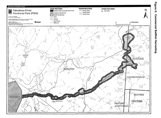
Enlarge this map of commercial baitfish harvesting areas within Pukaskwa River Provincial Park
Fish stocking
The stocking of native fish species may be considered through park management planning, with full public and Aboriginal consultation. Non-native fish species will not be deliberately introduced into park waters (OMNR 1992).
6.0 Operations policies
6.1 Recreation management
Future planning with full public and Aboriginal consultation will review direction on motorized and non-motorized recreation activities.
6.1.1 Motorized recreation
Motorboats
The use of motorboats is permitted to continue, unless park values are threatened (OMNR 2004a).
Aircraft
Aircraft landings are permitted in this waterway park (OMNR 2004a). Aircraft landings are subject to authorization through a valid aircraft landing permit issued by the park superintendent. Longterm direction for aircraft landings will be determined through future planning.
Snowmobiles
There are currently no authorized snowmobile trails located within Pukaskwa River Provincial Park.
The park is in a remote location. There are no private land in-holdings, or recreational LUPs in the park. Snowmobile use is expected to be low. Snowmobiling may occur with recreational ice fishing on the headwater lakes. This may be authorized to continue should evaluations determine that such use does not conflict with the protection of park features and values.
Proposals for new trails may only be considered through future planning with public and Aboriginal consultation (OMNR 2000).
Off-trail snowmobile use is not permitted within the park.
All-terrain vehicles
There are no authorized all-terrain vehicle (ATV) trails located within this park. Proposals for new trails may only be considered through future planning with public and Aboriginal consultation (OMNR 2000).
This park is in a remote location. There are no private land in-holdings or LUPs within the park. ATV use may occur at low levels. Unauthorized use by ATVs is not permitted.
6.1.2 Non-motorized recreation
Camping
There are currently four unmanaged campsites associated with the canoe route within Pukaskwa River Provincial Park. There are no managed camping facilities within this park.
Ontario Parks may assess the condition of existing campsites and will maintain, rehabilitate or close sites as required. If there is an identified need, new backcountry campsites may be considered (OMNR 2004a). Infrastructure will be permitted in order to protect park features and values in response to use, environmental deterioration and environmental protection requirements.
Any proposed development in the park must fulfill the requirements of the Environmental Assessment Act.
Hiking
There are no authorized hiking trails located within the park.
If there is an identified need, the development of new hiking trails may be considered. Trail infrastructure to protect park values and features will be permitted. Any proposed development within the park is subject to Environmental Assessment Act requirements.
Canoeing/kayaking
There is an existing canoe route along the length of the park. Portages will be managed to provide safe passage- non compatible uses are prohibited (e.g. ATVs). Existing uses may continue, unless park values are threatened (OMNR 2004a). Infrastructure to protect park features and values may be permitted ad developed to manage use, environmental deterioration, and environmental protection requirements.
6.1.3 Emerging recreational uses
There are emerging recreational uses for which there is limited or no policy to deal with their management (e.g. adventure racing, geocaching). The park superintendent will use legislation, policy and guidelines which are in place to manage emerging uses.
6.2 Development
There is no existing park infrastructure located within the boundary this park. Infrastructure to protect park features and values may be permitted and developed in response to use, environmental deterioration and environmental protection requirements. Any proposed development within the park is subject to MNR’s requirements under the Environmental Assessment Act.
6.3 Commercial tourism
There is no infrastructure for commercial tourism within the park. New commercial tourism facilities may be considered where consistent with park policy (OMNR 2004a). Any development must meet the requirements of the Environmental Assessment Act.
7.0 Cultural resources
An assessment of the cultural resources specific to Pukaskwa River Provincial Park has not been completed at this time. As information becomes available the management of all cultural values within this park will be directed toward protection and heritage appreciation (OMNR 1992).
8.0 Heritage education
Literature, maps and other supporting information may be developed to describe the park in the context of Ontario’s provincial park system. Boundary limits, significant heritage features and permitted uses of the waterway park may be included in park information. Ontario Parks will collaborate with Pukaskwa National Park for this purpose.
Prospective park visitors may be informed about the sensitivity and significance of park values through park information.
9.0 Research
Scientific research by qualified individuals which contributes to the knowledge of natural or cultural history, or to environmental or recreational management, may be encouraged in the park. Ontario Parks will encourage institutions, such as universities, to undertake research projects.
All research programs will require the approval of Ontario Parks and are subject to park policy and other applicable legislation. Any materials removed from the park will remain the property of Ontario Parks.
10.0 References
Canadian Environmental Protection Act, 1999.
Environmental Assessment Act, 1990.
Fisheries Act, 1985.
Fish and Wildlife Conservation Act, 1997.
Kershaw, W., 2002. Pukaskwa River Provincial Park Recreation Inventory Report- Version 1.5. Ontario Ministry of Natural Resources.
Kor, P., 2003. Earth Science Checksheet for Pukaskwa River Provincial Park. Ontario Ministry of Natural Resources
Mason, B., 1984. Waterwalker. National Film Board of Canada.
Migratory Birds Convention Act, 1994.
Mining Act, 1990.
Morris, E., 2001. Life Science Checksheet for Pukaskwa River Provincial Park. Ontario Ministry of Natural Resources.
Ontario Ministry of Natural Resources, 1974. A Topical Organization of Ontario History. Historic Sites Branch Division of Parks.
Ontario Ministry of Natural Resources, 1992. Ontario Provincial Parks Planning and Management Policies.
Ontario Ministry of Natural Resources, 1999. Ontario’s Living Legacy Land Use Strategy. July 1999.
Ontario Ministry of Natural Resources, 2000. Ontario’s Living Legacy Land Use Strategy Policy Clarification.
Ontario Ministry of Natural Resources, 2003. Directions for Commercial Resource Use Activities in Provincial Parks and Conservation Reserves. 5 pp.
Ontario Ministry of Natural Resources, 2004a. Crown Land Use Policy Atlas.
Ontario Ministry of Natural Resources, 2004b. Forest Fire Management Strategy for Ontario. Aviation and Fire Management Branch.
Ontario Ministry of Natural Resources, 2005a. A Class Environmental Assessment for Provincial Parks and Conservation Reserves.
Ontario Ministry of Natural Resources, 2005b. List of Forest Management Units and Forest Management Plan Renewal Schedule 2005.
Pesticides Act, 1990.
Provincial Parks Act, 1990.
Appendix I: Consultation
In August 2019, this management statement was amended to allow for a hydro line crossing. On February 7, 2017, a policy proposal notice was posted on the Environmental Registry for the review of the proposed amendments. The comment period occurred between February 7, 2017 - March 24, 2017. Letters were also sent to Indigenous communities and other interested or affected stakeholders to notify, and request input, on the proposed amendments to park management direction. As a result of consultation, a total of 3 comments were received. One comment was supportive of the East-West Tie project. Two comments requested more information about the project.
Appendix II: Background information
- Name: Pukaskwa River Provincial Park (P1513)
- Classification: Waterway
- Ecoregion/Ecodistrict: 3E-4 Tip Top Mountain, 3E-5 Foleyet
- OMNR Administrative Region/District: Northeast – Wawa
- Total Area (ha): 1,465
- Regulation date & Number: November 2002 (O. Reg. 311/02)
Representation
Earth science
The Pukaskwa River has spectacular scenery, attributed in part to visible bedrock geology and glacial features. This is evident in Ringham’s Gorge, a one and a half kilometre long gorge with rapids. This gorge contains belts of greenstone, within the steep cliffs, which are representative. The Pukaskwa River plain encompasses an ancient glacial spillway corridor and delta.
Bedrock consists of an undifferentiated, foliated to gneissic, tonalite suite of intrusive rocks and minor metasedimentary rocks which lie in the Wawa Subprovince, Superior Province, Canadian Precambrian Shield. Surficial sediments consist largely of massive boulder lags concentrated in bends and narrows of the river. These represent lags from glaciofluvial activity in early postglacial time.
Life science
The site crosses from Ecodistrict 3E-5 to 3E-4. Forests included in the site are representative of Ecoregion 3E. The majority of the stands are old-growth. The major forest associations include Jack pine, black spruce, white birch, and poplar.
The Pukaskwa is a small cold-water river, which is flanked by small riparian wetlands and shrub thickets. Flow volume in the river can be quite low during the early summer. The headwaters of the site include two coldwater lakes, Gibson and Jarvey lakes.
Cultural resources
An investigation and analysis of the cultural resources specific to Pukaskwa River Provincial Park has not been completed at this time.
Recreation and tourism
Linked to Pukaskwa National Park, Pukaskwa River Provincial Park provides extended backcountry camping and wilderness experiences. The Pukaskwa River Canoe Route travels through the provincial and national parks to Lake Superior. This route is rugged and remote - recommended for advanced level canoeists and backcountry travellers only.
There are no developed camping or tourism facilities within this park. There are four unmanaged campsites that are used in association with the canoe route.
Inventories
| Survey Level | Earth Science | Life Science | Cultural | Recreational |
|---|---|---|---|---|
| Reconnaissance | Kor, 2003 | Morris, 2002 | Required | Kershaw, 2002 |
Footnotes
- footnote[1] Back to paragraph Transfers include situations where a license is surrendered with a request that it be immediately reissued to another individual or organization that is assuming an existing operation. Trap cabins are considered part of a trapline and would be transferred with the trapline for the purposes of trapping. If a trapline license is revoked or surrendered, all portions of the registered line within the park will be rescinded from the legal description of the trap line (OMNR 2003).