Pyatt Lake Conservation Reserve Management Statement
This document provides policy direction for the protection, development and management of the Pyatt Lake Conservation Reserve and its resources.
Statement of Conservation Interest
June, 2003
Dryden District
Ministry of Natural Resources
Approval statement
We are pleased to approve this Statement of Conservation Interest for Pyatt Lake Conservation Reserve (C2307).
This Statement of Conservation Interest will provide guidance for the management of the Conservation Reserve and form the basis for ongoing monitoring of activities. More detailed direction is not anticipated at this time. Should significant facility development be considered or complex issues arise requiring additional studies, more defined management direction, or special protection measures, a more detailed Conservation Reserve Management Plan will be prepared with full public consultation.
The Pyatt Lake Conservation Reserve will be managed under the jurisdiction of the Dryden and Wabigoon Area supervisors, Dryden District, Ministry of Natural Resources.
Signed by:
R.G. McColm
Dryden District Manager
Ministry of Natural Resources
Date: June 30, 2003
Signed by:
Charlie Lauer
Regional Director
Northwest Region
Ministry of Natural Resources
Date: July 16, 2003
1.0 Background information
The purpose of this document is to identify and document the natural heritage values of the Pyatt Lake Conservation Reserve, the activities that occur there and, through a set of management guidelines, lay out the activities that will and will not be permitted. For more information regarding this Statement of Conservation Interest (SCI) please refer to the "Conservation Reserve Policy and Procedure PL3.03.05".
Table 1.1: Background information for the Pyatt Lake Conservation Reserve.
| Name | Pyatt Lake Conservation Reserve (C2307) |
|---|---|
| Site Region / Site District | 4S-4 |
| OMNR Administrative Region / District / Area |
Northwest Region / Dryden District / Dryden Area/ Dryden Forest (and Wabigoon Area/ Wabigoon Forest to a smaller extent) |
| Total Area (ha) | 405 |
| Regulation Date | Anticipated for 2003 |
| First Nations | Wabigoon Lake Ojibway Nation, Eagle Lake First Nations |
| OBM | 15 5500 54900, 15 5600 54900 |
| Latitude / Longitude | 49' 34 / 92' 09 |
| Basemap | 55549, 56549 |
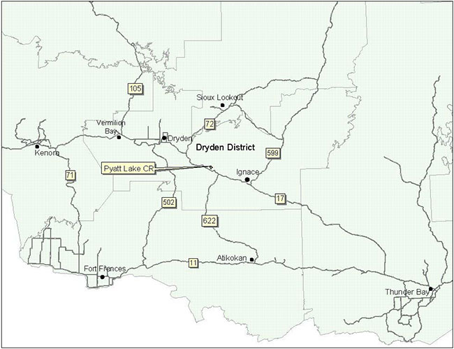
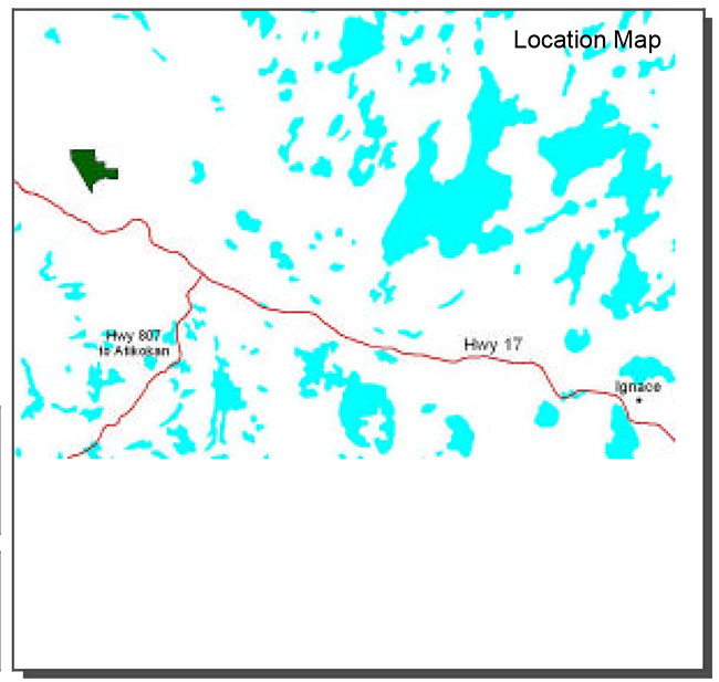
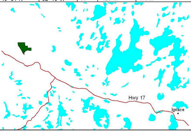
| General Location Description | The reserve is located approximately 54 km southeast of the City of Dryden (~61 km by road) |
| Access | Access to the reserve may be gained via travel down Basket Lk. Rd for about 3 km. up to the railway tracks. At this time one must head in an easterly direction for approximately 1 km via foot. |
Table 1.2: Representation targets – A summary of earth science, life science, cultural resource values and present or possible recreational opportunities.
| Life science representation |
|
|---|---|
| Earth science representation |
|
| Cultural value representation |
|
| Recreational opportunities |
|
Table 1.3: Survey Information – Overview of inventories completed, their level of detail and any inventories that are needed.
| Survey Level | Life Science | Earth Science | Cultural | Recreational |
|---|---|---|---|---|
| Reconnaissance | Life Science Checklist, 2002 |
Earth Science Checklist, 2002 |
not required | Recreation Inventory Checklist, 2002 |
| Detailed | not required | not required | not required | not required |
Figure 1: General location of the Pyatt Lake Conservation Reserve.
Enlarge Figure 1: General location of the Pyatt Lake Conservation Reserve.
2.0 Values to be protected
This section provides a description of the key natural heritage values on the site, their condition relative to past resource and management activities, and their sensitivity to future land use and management activities.
Table 2.1: Values identified on the Pyatt Lake Conservation Reserve.
| Life Science |
|
|---|---|
| Earth Science |
|
| Cultural | N/A |
| Aboriginal | N/A |
| Tourism | N/A |
| Recreational Fishing | N/A |
| Recreational Hunting |
|
| Trapping |
|
| Bear Management Area |
|
| Bait Harvesting |
|
| Commercial Fishing | N/A |
2.2 Values to be protected
The intent of this SCI is to protect the following values by establishing management guidelines for existing and potential uses in this area given the level of past disturbance and the nature of the existing features.
2.2.1 Forest values
None of the forest values found require additional protection other than that provided by this Statement of Conservation Interest and the Pyatt Lake Conservation Reserve Policy Report (see Appendix F).
2.2.2 Biological values
Several species of rich fen vegetation that are also rare in northwestern Ontario were found to inhabit this area. These include twig rush, starved sedge, livid sedge and yellow-eyed grass. As well, the zig-zag darner, a provincially rare dragonfly species, was seen during the life science inventory. Some regionally rare bird species may also use the reserve for nesting, including the sharp- tailed grouse. Sandhill cranes were observed during the recreation and life science inventories.
2.2.3 Landform values
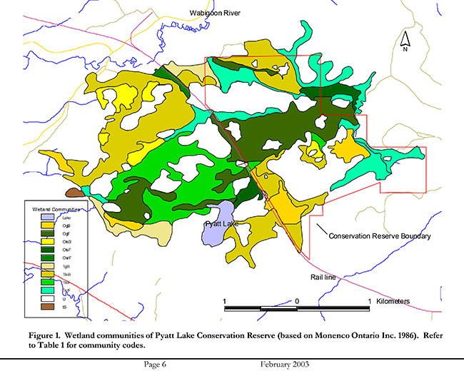
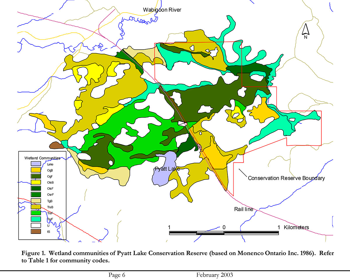
The peatland makes up 56% of the Pyatt Lake Conservation Reserve. The peat itself has an average depth of 2 m. (Harris et al, 2002) These organic deposits are of regional significance (Blackburn, 2002).
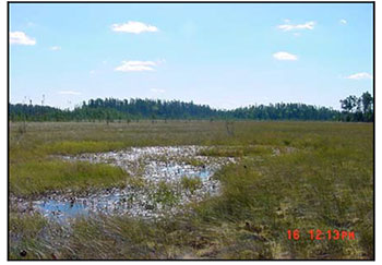
2.2.4 Recreational values
The wetland vegetation, organic material, coniferous forest and general wildlife were considered to be recreation features. One potential activity was determined for this reserve; bird watching. Sensitivity to recreation use was deemed not applicable due to the only recreation activity listed being only a potential activity and relatively noninvasive. The wetland vegetation was considered to be most sensitive to resource development. (See Appendix E)
2.2.5 Tourism values
No tourism values exist within the reserve.
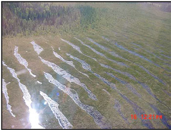
Figure 2: Aerial view of the string fen within the reserve.
3.0 Management guidelines
3.1 Land tenure
The Pyatt Lake Conservation Reserve consists entirely of Crown land. Several patented mining claims exist around (but not within) the reserve.
The reserve will remain Crown land and no additional dispositions (including Land Use Permits or Licenses of Occupation) will be issued for the site.
The disposition of adjacent Crown Land will be dealt with on a case-by-case basis.
Unauthorized occupations of lands within the conservation reserve will be handled in accordance with approved policy, and any required structural removal will be at the owner’s expense.
3.2 Existing and proposed development
The CPR line runs parallel to the southwest boundary of the reserve. An old winter road did exist in the north end of the reserve. It is now impassable. There is no additional development within the reserve. In the immediate surrounding area, additional secondary and forest access roads, gravel pits and timber harvest operations can be found.
Facility infrastructure and development for recreational and/or educational purposes may be considered in the future if there is a demonstrated demand for such facilities. All provincial policies that guide development on Crown Land are applicable in Conservation Reserves. A more detailed management plan would be required prior to any development occurring. Such a plan would have to ensure that there would be no negative impacts to any habitat or ecosystem pertinent to the values protected in this reserve.
3.3 Recreational activities
Recreational activities that have traditionally been enjoyed in this area can continue provided they pose no threat to the natural ecosystems and features protected by the Conservation Reserve. Some activities, particularly those involving the use of trails, may produce compaction of the peat within the reserve, resulting in alterations to hydrological processes and changes in vegetation communities. Due to the sensitive nature of the peatland to impaction no new trail development will be permitted.
Figure 3: Rich fen found within the reserve.
Mechanical travel within conservation reserves is permitted only on existing roads and trails. Off trail mechanized travel is permitted for retrieval of game only. Currently, there are no trails within the Pyatt Lake Conservation Reserve.
Regulated uses in Conservation Reserves include hunting, fishing and trapping. Most other permitted activities are non- regulated (i.e. canoeing, exploring). See Section 2.2.4 for the recreational uses for this Conservation Reserve as determined by the Recreation Resource Inventory.
3.4 Commercial activities
No new activities, such as commercial logging, hydroelectric power development, new transmission lines (e.g. power or communications), pipelines, highways or roads, and the extraction of minerals, aggregate or peat will be permitted.
An examination of the possible impact of activities on adjacent lands should be evaluated in the Forest Management Plan.
3.5 Aboriginal interests
Pyatt Lake Conservation Reserve (C2307) lies within Treaty 3 area. To date, no Aboriginal Groups have voiced any issues in regard to this Conservation Reserve. Nothing in this Statement of Conservation Interest affects in any way existing or future Aboriginal or treaty rights.
3.6 Natural Resources Stewardship
Natural Resource Stewardship involves the consideration of the following specific natural resource management categories.
3.6.1 Vegetation management
Management within the Conservation Reserve will allow for the continuation of natural ecosystem processes and functions with minimal human interference.
Forest fire suppression will be carried out in accordance with the approved Fire Management Strategy for the surrounding lands. "Light on the Land" suppression techniques which do not unduly disturb the landscape will be encouraged where feasible. Examples of "light on the land" techniques may include limiting the number of trees felled or the use of heavy equipment or foam.
Opportunities for prescribed burning to achieve ecological or resource management objectives may be considered. These management objectives will be developed with public consultation prior to any prescribed burning, and reflected in the document that provides management direction for this conservation reserve. Plans for any prescribed burning will be developed in accordance with the MNR Prescribed Burn Planning Manual, and the Class Environmental Assessment for Provincial Parks and Conservation Reserves (approval pending).
Forest insect and disease management will continue as on surrounding Crown lands.
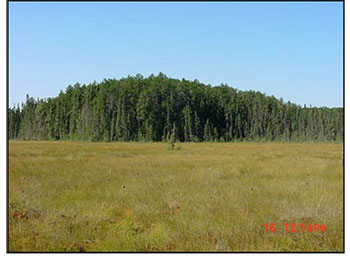
Figure 4: Upland forest area within the reserve.
3.6.2 Fish and wildlife management
The existing Wildlife Management Unit, sport fishing regulations and management activities will apply. As well, it is recommended that surveys for sharp-tailed grouse, sandhill cranes and other regionally rare nesting peatland birds should be conducted to determine whether or not they do nest within the reserve (Harris et al, 2002).
3.6.3 Landforms
None of the landforms mentioned will be altered by landform modification activities such as filling and extraction. The extraction of aggregates and similar materials are not permitted.
Mineral exploration and extraction are not permitted in the CR.
3.7 Cultural Resources Stewardship
To date, there have been no surveys done to assess cultural or heritage values. However, common knowledge of the area suggests there to be no such values on this site, thus Cultural Inventories were deemed unnecessary.
3.8 Client services
Given the focus on low key management, client information will be given on an inquiry basis only and will deal with the basic level of information with respect to access, natural heritage appreciation, recommended activities and boundaries.
3.9 Research
Non-destructive research by qualified individuals will be encouraged to provide a better understanding of the natural values protected by the Conservation Reserve and to advance protection, planning and management.
In order to assist with enhancing the management guidelines for the reserve, the collection of additional earth and life science information during research is encouraged.
All research programs will require the approval of the Ministry of Natural Resources as will the removal of any natural or cultural specimen. The establishment of permanent plots, observation points or facilities must also be approved and be compatible with the Conservation Reserve protection objective. Any site disturbed by research activities must be rehabilitated as closely as possible to its previous state.
3.10 Marketing
Awareness of the Conservation Reserve is promoted through the Living Legacy web site. Intensive management activity to increase use is not required at this time.
4.0 Implementation
Implementation of this Statement of Conservation Interest will primarily involve monitoring activities to ensure adherence to the management guidelines and responding to inquiries about the site.
Implementation of this statement and management of the reserve are the responsibility of the Dryden Area Supervisor. Partnerships may be pursued to address management needs.
5.0 Review and revisions
5.1 Review and revisions
This Conservation Reserve Statement of Conservation Interest will be reviewed on an ongoing basis.
If changes in management direction are needed at any time, the significance of the changes will be evaluated and further consultation a possibility. Any major amendments will require full public consultation and the approval of the District Manager and Regional Director. Affected clients will be immediately informed of proposed changes to this Statement of Conservation Interest.
5.2 Public consultation
5.2.1 Results of past consultations
Consultation on the Pyatt Lake Conservation Reserve was conducted as part of the consultation on the Ontario’s Living Legacy Land Use Strategy, July 1999. Subsequent consultation also took place in June 2001 to refine the boundary of the Conservation Reserve.
District Manager letters, totaling 94, were sent to the Dryden Forest Management Co., Weyerhaeuser and Ontario’s Forest Industries Association Tourist Outfitters, Advisory Committees, Trappers, Land Owners, Members of the Public, Non-Government Organizations and Government Organizations. Newspaper ads were placed in the Ignace Driftwood June 20, 2001 and Dryden Observer on June 19, 2001.
First Nation Consultation letters were also sent to ten Native communities/organizations including the Wabigoon Lake Ojibway Nation and Aboriginal People of Wabigoon. Direct consultation with Treaty 3 First Nations was carried out on a regional basis and has been completed.
One general inquiry was made concerning permitted uses in Conservation Reserves. As a result of the public consultation process, no issue analysis was required. No issues have been voiced to date from any of the Native groups.
5.2.2 Present and future consultation
More widespread consultation is deemed unnecessary at this time.
5.2.3 Author
This Statement of Conservation Interest was prepared by Alicia H.L. Morin, OLL Intern, Information Management, Dryden District. Assistance was provided by Martin Pell (Dryden District Planner) and members of the Dryden Area Team.
6.0 References
Blackburn, C. 2002. Earth Science Inventory – Pyatt Lake Conservation Reserve. Unpublished report for Northwest Region MNR, Thunder Bay, Ont.
Harris, A. and Foster, R. 2002 Life Science Inventory – Pyatt Lake Conservation Reserve. Unpublished report for Northwest Region MNR, Thunder Bay, Ont.
Ministry of Northern Development and Mines (MNDM). 1986. Peat and Peatland Evaluation of the Dryden-Lac Seul Area.
Noble, T. 1995. Site District 4S4 gap analysis. Unpublished report for Northwest Region, OMNR, Thunder Bay, Ont.
Ontario Ministry of Natural Resources (OMNR). 1999. Ontario’s Living Legacy Land Use Strategy. p. 24. Queen’s Printer for Ontario.
Ontario Ministry of Natural Resources (OMNR). 2002. Pyatt Lake Conservation Reserve (C2292) Recreation Resource Inventory Report. Unpublished report for Dryden District MNR.
Ontario Ministry of Natural Resources (OMNR). Lands & Natural Heritage, Lands & Waters. 1997. Conservation Reserve Policy and Procedure PL 3.03.05. 22 pp.
Appendix A:
Pyatt Lake Conservation Reserve (C2307) Values Map
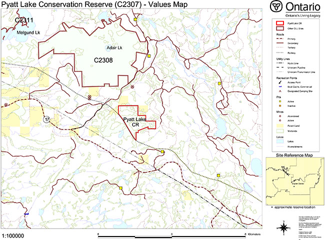
Enlarge Pyatt Lake Conservation Reserve (C2307) values map
Appendix B:
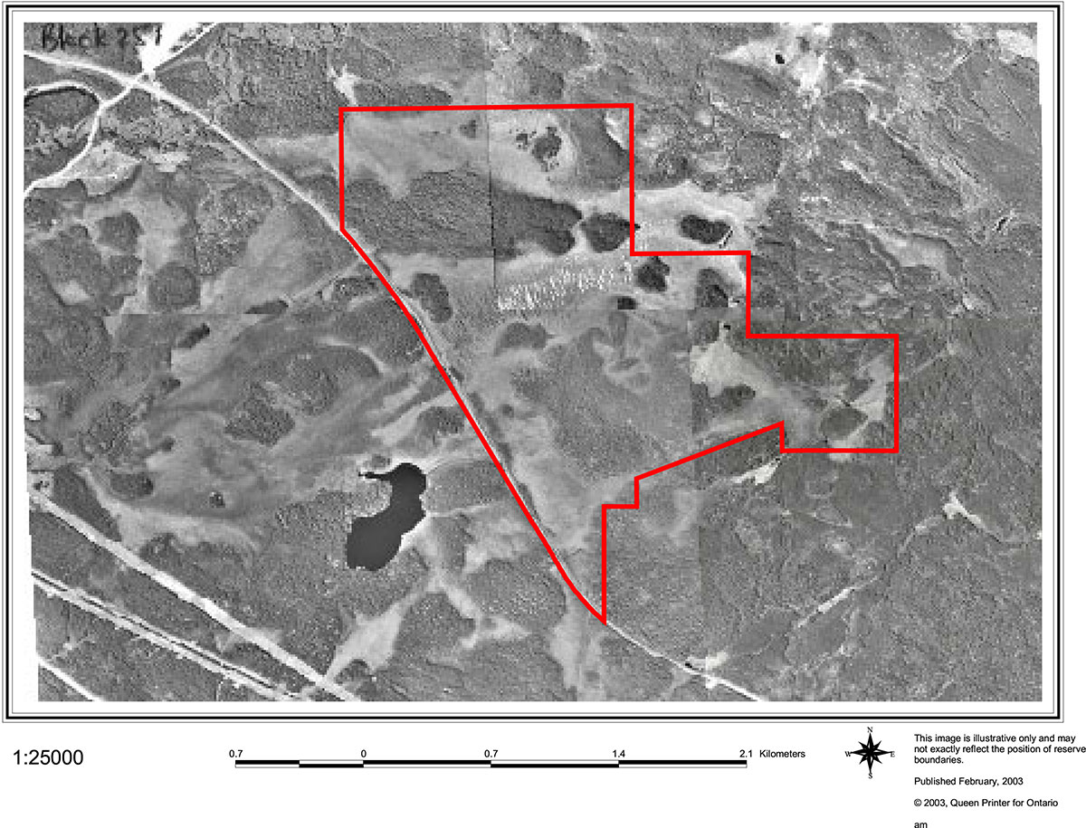
Pyatt Lake Conservation Reserve (C2307) aerial photo image
Pyatt Lake Conservation Reserve-Aerial Photo Image

Enlarge Pyatt Lake Conservation Reserve-Aerial Photo Image
Appendix C:
Pyatt Lake Conservation Reserve (C2307) earth science Checksheet
Detailed information for site C2307 Pyatt Lake
Protection history
The reserve was identified under the provincial Lands for Life - Ontario’s Living Legacy Program as containing "a treed low shrub bog, open graminoid fen, and other bogs, swamps and fens." (OMNR 1999).
No previous earth science significance was assigned.
Setting
The reserve comprises 401 hectares, and is located in Dryden MNR District. Elevations range from 420 m a.s.l. at Pyatt Lake to 440 m a.s.l.
Earth science features
Bedrock geology
Pyatt Lake Conservation Reserve is underlain almost entirely by granitic rocks of the Revell batholith, a part of the Archean age Wabigoon Subprovince (Blackburn et al 1991) of the Superior Province. It lies at the northern tip of the batholith (Blackburn et al 1991: Figure 9.2), where the granitic rocks are in contact with volcanic rocks of a narrow greenstone belt extension that lies between the Revell and Basket Lake batholiths. Mapping by Satterly (1960) indicates that a very small portion of the greenstone belt underlies the extreme northeast corner of the reserve, but not in outcrop: basalt outcrops lie immediately outside, to the north.
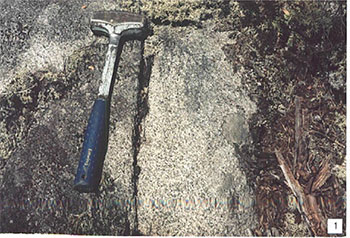
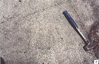
Granitic rocks observed in the Revell batholith during the present inventory are massive, equigranular, medium to coarse grained quartz diorite (stations 1 and 2: photo 1) to monzodiorite (station 3: photo 2). In places along the margin of the batholith assimilation of basaltic rocks has resulted in a hybrid granitic rock of dioritic composition: a few small outcrops are indicated on Map 1960h (Satterly 1960) to lie within the reserve boundary, but were not visited during the present inventory. Elsewhere, rocks of the batholith are more silica rich, and of granodioritic composition (Map 1960h, Satterly 1960).
Surficial geology
Quaternary deposits are of both Pleistocene, glacial, and Recent, postglacial, age (Roed 1980; Cowan and Sharpe 1991). The northwest trending Hartman end moraine lies about 5 km to the northeast of the reserve. To the southwest of the Hartman moraine sand, gravel and boulder material has been variously interpreted as glaciofluvial outwash (Roed 1980) and shallow water glaciolacustrine (Cowan and Sharpe 1991; Barnett et al 1991). Proglacial, glaciofluvial outwash material that was deposited at the edge of the retreating Wisconsinan age glacier was most likely reworked at the edge of glacial Lake Agassiz. Difficulty in distinguishing between the two types of material may account for the variability in map interpretation. On the accompanying surficial geology map to this report preference has been given to the glaciolacustrine interpretation, with the understanding that some of the material may be glaciofluvial. Shallow drift over bedrock that occupies about 40% of the reserve area may be of this material.
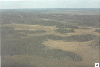
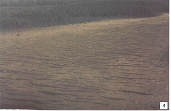
Organic deposits of Recent age occupy about 50% of the reserve, as bog, fen and swamp. A string bog is conspicuous in the centre of the reserve (photos 3 and 4). The area of organic deposits is separated from another portion of about equal size that lies to the southwest of the Canadian Pacific Railway line that forms the southwest margin of the reserve. Pyatt Lake itself lies at the southern margin of this excluded area.
Significance
The granitic bedrock is typical of vast tracts of the Precambrian of Ontario, but not well exposed, and incorporates only a very small portion of the Revell batholith. It is therefore considered to be not significant. The shallow drift over bedrock, the only Pleistocene deposit, is not considered to be significant. The organic deposits which support the life science features for which this area was reserved, constitute the only earth science feature of note, and are of regional significance.
Sensitivity
Bedrock features are not susceptible to degradation by either human activity or natural processes. The organic deposits are highly susceptible to alteration if the vegetation cover is disturbed. They may also be destroyed by commercial exploitation.
Recommendations
Conservation Reserve status adequately protects the organic deposits from disturbance and exploitation.
The present survey has adequately identified both bedrock and surficial features of the reserve. No further recommendations for inventory are made.
References
Barnett, P.J., Henry, A.P. and Babuin, D. 1991. Quaternary Geology of Ontario, west-central sheet; Ontario Geological Survey, Map 2554, scale 1:1 000 000.
Blackburn, C.E., Johns, G.W., Ayer, J. and Davis, D.W. 1991. Wabigoon Subprovince; in Geology of Ontario, Ontario Geological Survey, Special Volume 4, Part 1, p. 303-381.
Cowan, W.R. and Sharpe, D.R. 1991. Surficial Geology, Wabigoon Lake, Ontario; Geological Survey of Canada, Map 1774A, scale 1:100 000.
Roed, M.A. 1980. Northern Ontario Engineering Geology Terrain Study, Data Base Map, Wabigoon Lake; Ontario Geological Survey, Map 5059, scale 1:100 000.
Satterly, J. 1960. Dyment area; Ontario Geological Survey, Map 1960h, scale 1:31 680.
OMNR 1999. Ontario’s Living Legacy: Land Use Strategy; Ontario Ministry of Natural Resources, 136p. accompanied by map, scale 1:1 200 000.
Photographs
1. Grey, massive, equigranular quartz diorite of the Revell batholith. (Stn. 2; UTM 0560542E 5491324N)
2. Grey to pink, massive monzodiorite of the Revell batholith. Note larger scattered black hornblende crystals. (Stn. 3; UTM 0561449E 5490943N)
3. View to the west over Pyatt Conservation CPR line at upper left, stations 1 and 2 at far left centre. A string bog is located between the tracks and stations 1 and 2.
4. Closer view of the string bog in Photo 3.
Additional station
Stn. 1 UTM 0560507E 5491411N
Earth Science Inventory Checklist
| Name | Pyatt Lake |
|---|---|
| OLL ID | C2307 |
| Map Name | Dyment |
| NTS Number | 52F/09 |
| UTM reference | Z15 551000E 549 |
| OBM Number | |
| Latitude | 49° 34' N |
| Longitude | 92° 10' W |
| Elevation - Maximum | 440m |
| Elevation - Minimum | 420m |
| County | District of Kenora |
| Township | Revell, Hyndman |
| Lot | 12, 1 through 3 |
| Concession | 2 and 3 |
| Area (ha) | 401.00 |
| Ownership | Crown |
| Air Photo Year / Roll/ Flight Line/ Number |
97-57-4920A-37to39; 97-57- 4919A-19,20 |
| MNR Region | Northwest |
| MNR District | Dryden |
| Park Zone | Northwest |
| Earth Science Features | Archean age, Wabigoon Subprovince: single granitic phase of Revell batholith - quartz diorite to monzodiorite to granodiorite. ~50% bedrock (overlain by shallow surfical material). Pleistocene age: shallow drift over bedrock, of shallow water glaciolacustrine or glaciofluvial outwash origin. ~40% of reserve. Recent age: organic deposits as bog, fen and swamp. |
| Significance | Granitic bedrock is typical of vast tracts of Precambrian of Ontario, but not well exposed, and incorporates only a small portion of the Revell batholith - not significant. The shallow drift over bedrock is not considered significant. The organic deposits are representative of those in northwest Ontario in general, and therefore of regional significance. |
| Sensitivity | Bedrock features are not sensitive to natural or cultural impacts. The organic deposits are susceptible to commercial exploitation. |
| Recommendations | Conservation reserve status adequately protects the organic deposits from exploitation. |
| Major References | Blackburn et al 1991, "Wabigoon Subrovince" in OGS Special Volume 4; Cowan and Sharpe 1991, GSC Map 1774A; Roed 1980, OGS Map 5059; Satterly 1960, OGS Map 1960h. |
Earth Science Inventory Checklist Location Map
Date Compiled: February 15, 2003
Compiler:
C.E. Blackburn,
Blackburn Geological Services
Ontario Ministry of Natural Resources, Ontario Parks
300 Water Street, Peterborough, Ontario K9J 8N1
Appendix D:
Pyatt Lake Conservation Reserve (C2307) Life Science Checksheet
C2307 Pyatt Lake
Natural Heritage Area – Life Science Checksheet
| Name | Pyatt Lake |
|---|---|
| Map Name | Dyment |
| Map Number | 52F-9 |
| UTM reference | Zone 15 551000 E 5491000 N |
| County | Kenora |
| Latitude | 49° 34' N |
| Longitude | 92° 10' W |
| NAD | 83 |
| Minimum Altitude | 420 m |
| Maximum Altitude | 440 m |
| Locality | 55 km SE of Dryden |
| Township | Revell, Hyndeman |
| Area | 401 ha |
| Ownership | Crown |
| MNR Region | Northwest |
| Ecoregion and Ecodistrict | 4S-3, 4S-5 |
| Landform Unit | See Table 3 |
| MNR District | Dryden Aerial Photographs |
| Air Photographs Year / Roll/ Flight Line/ Number |
97-4920-A-57-38 97-4919-A-57-20 |
Natural Heritage Area Map
Physical and biological features
The Pyatt Lake Conservation Reserve consists of a patterned peatland studded with bedrock islands in a shallow glaciolacustrine basin. The peat deposits are underlain by medium to very fine outwash and Aeolian sands. The topography is flat, with less than 20 m of elevational difference.
The Pyatt Lake peatland developed on a sandy deposit a few kilometers southwest of the Hartmann Moraine. The sand is probably glacial outwash that was subsequently reworked by Lake Agassiz. Originally several smaller peatlands occupied the area and coalesced as the peat deposits spread. A 10 cm thick layer of basal ooze at the bottom of the peat deposit suggests that much of the area was originally a lake before being filled by peat (Monenco Ontario Ltd. 1986). The peat is fairly shallow with an average depth of 2 m. The top half to two-thirds is poorly decomposed (fibric) shrub-Sphagnum peat over more well decomposed (fibric-mesic) shrub-sedge peat.
The peatland slopes from northeast to southwest as indicated by the "string" patterns, oriented perpendicular to the direction of water flow. Three creeks drain the peatland into the Revell River and the Wabigoon River.
Peatland makes up 56% of the Conservation Reserve ( Table 1), of which about 60% is fen and 40% is bog/poor fen. Most of the area designated as "bog" in Ontario Peatland Inventory mapping (Monenco Ontario Inc 1986) is better described as poor fen due to the presence of minerotrophic indicator plants. The total area of the Pyatt Lake peatland encompasses over 600 ha, about half of which is within the Conservation Reserve.
A large "string fen" with distinctive linear ridges and pools dominates the central part of the peatland where the groundwater flow is greatest. Vegetation consists of open extremely rich fen (ES43) with sedges and low shrubs on the low peat ridges and sundew and intermediate bladderwort in the pools. Indicators of mineral-rich conditions include twig rush, shrubby cinquefoil, starved sedge, livid sedge and tufted clubrush.
Treed fen (ES40), with small widely spaced tamarack and black spruce, lines the edges of the main groundwater flow where it is slightly drier.
Bog and poor fen (ES39 and ES41) are found on the stagnant edges of the basin where there is less groundwater flow. Open bogs (ES39) are dominated by few-seeded sedge, ericaceous shrubs and Sphagnum mosses. Treed bog (ES34) has similar vegetation, but with scattered small black spruce trees.
Upland forests consist of jack pine and black spruce (ES20) and trembling aspen (ES19) on shallow silty very fine sand. Coarser sand soils support jack pine forests (ES13). The raised islands within the peatland are bedrock knobs with a shallow cap of aeolian silty sand. Forests are relatively nutrient poor with a species poor shrub and herb layer.
Table 1. Wetland communities of Pyatt Lake Conservation Reserve (from Monenco Ontario Inc 1986).
| Wetland Class | Physiognomic Type | Map Code | Area (Ha) | % |
|---|---|---|---|---|
| Open Bog / Poor Fen | Open Graminoid Bog | OgB | 25.6 | 6 |
| Open Low Shrub Bog | OlsB | 3.1 | 1 | |
| Open Fen | Open Graminoid Fen | OgF | 71.0 | 18 |
| Open Low Shrub Fen | OlsF | 3.6 | 1 | |
| Treed Bog / Poor Fen | Treed Graminoid Bog | TgB | 2.7 | 1 |
| Treed Low Shrub Bog | TlsB | 55.8 | 14 | |
| Treed Fen | Treed Low Shrub Fen | TlsF | 3.6 | 1 |
| Treed Shrub Rich Fen | TsrF | 59.9 | 15 | |
| Upland | U | 176.2 | 44 | |
| Grand Total | 401.5 * | 100 |
* note different total area from Table 4 due to mapping differences
Representation
Table 3 summarizes representation of landform vegetation types of the Pyatt Lake Conservation Reserve for Ecodistrict 4S-3 and 4S-4 as recently refined by Ontario Parks (Steve Kingston pers. comm.). An older version of the landform vegetation representation matrix based on the original Ontario Living Legacy gap analysis is included for comparison (Table 4).
Table 4 accurately reflects that LV types on organic deposits (about 84% by area) dominate the reserve.
Bedrock landforms make up the rest of the reserve. The bedrock actually has a shallow cap of aeolian sand, but is in effect a bedrock landform.
Table 3 contains some errors. No open bog or open fen LV types were identified in the LV type representation matrix although fieldwork confirmed that they occur in the reserve. These LV types are "Organic Deposit – Open Bog" and "Organic Deposit – Open Fen" (see "Corrected Area" column in Table 3). Treed bog is under represented; apparently it has been misclassified as treed fen. Among the LV types not confirmed in the field are deciduous and mixed forests on organic deposits. These LV types are probably mapping errors, since deciduous forest typically does not occur on organic soils. LV types occurring in Ecodistrict 4S-5 were not visited in the field since they cover only 15 ha.
Elsewhere in Ecoregion 4S, similar vegetation is represented in Lola Lake Provincial Nature Reserve, Adair Lake Conservation Reserve and Airport Road Conservation Reserve. About 3.5% of the area roughly corresponding to 4S-2, 4S-3 and 4S-4 consists of peatland (Riley and Michaud 1989).
Condition
The main CNR line forms the southwest boundary of the Conservation Reserve. The embankment creates a dam and impedes the natural drainage of the peatland, despite drainage ditches on the downstream side of tracks. The vegetation has been altered due to water backing up on the upstream side of the tracks (i.e. in the Conservation Reserve). This influence extends 20 to 50 m east from the embankment with suppressed tree growth and more speckled alder compared to the drier downstream side.
The Conservation Reserve shows little evidence of other human impacts. There is approximately 2 km of old winter road within the reserve, which follows the north edge of the peatland. The road is apparently impassible now. Two bear management areas and one trapline area overlap the Conservation Reserve, but human activity in the peatland is probably negligible.
The Ontario Peatland Inventory assessment concluded that this site has too many mineral soil islands and insufficient peat depth to be viable for commercial peat extraction (Monenco Ontario Inc 1986). Peat extraction is not permitted in Conservation Reserves.
Diversity
The Pyatt Lake Conservation Reserve has relatively low diversity on the landscape scale, being relatively small and dominated by outwash and aeolian landforms. Wetlands contribute to the diversity with a range of peatland communities.
Eleven LV types occur in the reserve, although bog and fen LV types make up most of the area (Table 3).
Ecological function
The patterned fen community depends on groundwater flow from north of the Conservation Reserve. Land practices outside the Reserve that disrupt groundwater movement could impair hydrological processes.
The southwest edge of the Conservation Reserve follows the CPR rail line, posing the risk of spills, invasion of exotic plants, and fire originating from the rail line. The rail line also bisects the peatland, separating the Conservation Reserve from the rest of the wetland may present a dispersal barrier for some organisms.
This peatland is one of a series of similar landforms following the south edge of the Hartmann Moraine, facilitating dispersal of plants and animals between patches of habitat.
Special features
The rich patterned fen is a globally rare community type according to Nature Conservancy rankings (G2). This ranking may underestimate the abundance of the peatlands in northwestern Ontario and in the Hudson Bay Lowlands.
Plants found exclusively in rich fen habitats include twig rush, starved sedge, livid sedge, and yellow-eyed grass. Most of these species are rare in northwestern Ontario and near the western edge of their range at Pyatt Lake (Glaser 1992). Royal fern grows on strings in the patterned fen, an unusual habitat for this locally uncommon species.
A provincially rare dragonfly, zigzag darner (S1S3), was relatively common in the string fen in September 2002. Its habitat consists of large peatlands in boreal areas. However, sandhill cranes, sharp-tailed grouse and other regionally rare peatland birds probably nest here, given their distribution in the surrounding area. A migrating flock of sandhill cranes was observed during fieldwork, but no evidence of nesting was seen.
Recommendations
Surveys for sharp-tailed grouse, sandhill cranes, and other regionally rare nesting birds should be conducted.
Significance level and summary of major representative values
Pyatt Lake Conservation Reserve is regionally significant. The patterned fen is a distinctive landform with a diversity of bog and fen communities. The Conservation Reserve provides habitat for representative boreal peatland species, including the provincially rare zigzag darner. Several regionally rare plants inhabit the rich patterned fen.
Date Compiled
February 21, 2003
Compilers
Allan Harris and Robert Foster, Northern Bioscience
Major information sources
Glaser, P.H. 1992. Rare vascular plants. In: H.E. Wright, B.A. Coffin, and N.E. Aaseng. editors. Patterned Peatlands of Minnesota. University of Minnesota Press.
Harris, A.G., S.C.McMurray, P.W.C.Uhlig, J.K.Jeglum, R.F.Foster and G.D. Racey. 1996. Field guide to the wetland ecosystem classification for northwestern Ontario. Ont. Min. Natur. Resour., Northwest Sci. & Technol. Thunder Bay, Ont. Field Guide FG-01. 74 pp. + Append.
OMNR. 1999. Ontario’s Living Legacy – Land Use Strategy. Queen’s Printer, Toronto.
Monenco Ontario Ltd. 1986. Peat and peatland evaluation of the Dryden – Lac Seul area. 7 Volumes. Ontario Geological Survey. Open File Report 5544.
Noble, T. 1995. Site Region 4S-4 Gap Analysis. Unpublished report for Ontario Parks, Ont. Min. Natur. Resour. Thunder Bay, Ont.
Racey, G.D., A.G. Harris, J.K.Jeglum, R.F.Foster and G.M.Wickware. 1996. Terrestrial and wetland ecosites of northwestern Ontario. Ont. Min. Natur. Resour., Northwest Sci. & Technol. Thunder Bay, Ont. Field Guide FG-02. 88 pp. + Append.
Riley, J.L. and L. Michaud. 1989. Peat and peatland resources of northwestern Ontario; Ontario Geological Survey, Miscellaneous Paper 144, 175 pp.
Sims, R.A., W.D. Towill, K.A. Baldwin, P. Uhlig and G.M. Wickware. 1997. Field guide to the forested ecosystem classification for northwestern Ontario. Ont. Min. Natur. Resour., Northwest Sci. & Technol. Thunder Bay, Ont. Field Guide FG-03. 176 p.
Figure 1. Wetland communities of Pyatt Lake Conservation Reserve (based on Monenco Ontario Inc. 1986). Refer to Table 1 for community codes.
Map 1. Site map with significant features.
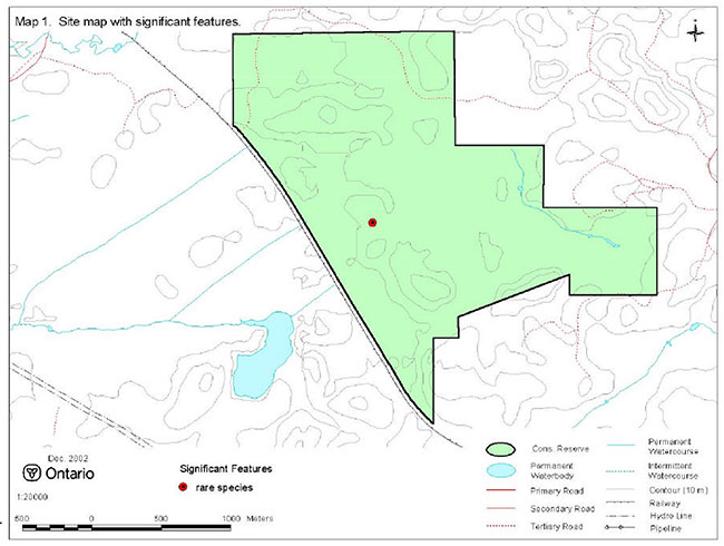
Enlarge Map 1. Site map with significant features.
Photo 1. The Conservation Reserve consists of a peatland with upland islands (photo by Alicia Morin).
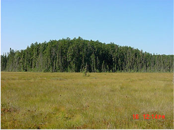
Photo 2. Distinctive string pattern in the rich fen (photo by Alicia Morin).
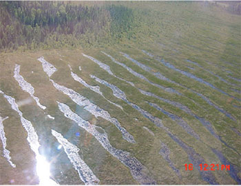
Photo 3. Treed fen and open fen make up 35% of the Conservation Reserve (photo by Alicia Morin).
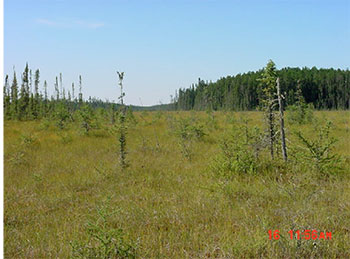
Photo 4. Several regionally rare plants inhabit the rich fen (photo by Alicia Morin).
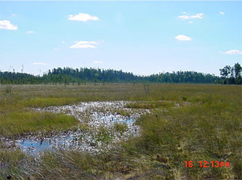
Photo 5. The CPR rail line borders the Conservation Reserve on the southwest.
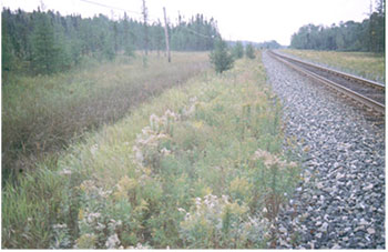
Table 2. Rapid assessment plot summary from Pyatt Lake.
| Plot No. | V / W Type | ES Type | Date |
|---|---|---|---|
| 1 | W17 | ES43 | Sept 16 2002 |
| 2 | W17 | ES43 | Sept 18 2002 |
| 3 | V16 | ES20M | Sept 18 2002 |
| 4 | W18 | ES40 | Sept 18 2002 |
| 5 | W20 | ES40 | Sept 18 2002 |
Table 3. Landform – vegetation (LV) type representation for Pyatt Lake Conservation Reserve in Ecodistrict 4S-3 and 4S-5 (analysis by Ontario Parks; Steve Kingston pers. comm.).*.
Ecodistrict 4S-3
| LV Description | Area (ha) | Ecodistrict Representation Target % |
Ecodistrict Representation Target ha |
Ecodistrict Protected Areas (ha) |
Pyatt Lake Area (ha) |
Pyatt Lake Corrected Area** |
Pyatt Lake Contribution to Ecodistrict Target (%) |
Pyatt Lake Contribution to Existing Protection (%) |
Pyatt Lake Confirmed in Field*** |
|---|---|---|---|---|---|---|---|---|---|
| Bedrock-Dense Coniferous Forest | 82,481 | 12 | 9,898 | 1,439 | 18 | <1 | 1 | X | |
| Bedrock-Mixed Forest – mainly Coniferous | 49,571 | 12 | 5,949 | 1,794 | 29 | <1 | 2 | X | |
| Bedrock-Sparse Coniferous Forest | 35,825 | 12 | 4,299 | 542 | 1 | <1 | <1 | X | |
| Bedrock-Dense Deciduous Forest | 31,139 | 12 | 3,737 | 989 | <1 | <1 | <1 | X | |
| Bedrock-Mixed Forest – mainly Deciduous | 17,953 | 12 | 2,154 | 250 | 1 | <1 | <1 | X | |
| Organic deposits-Dense Coniferous Forest | 3,389 | 12 | 407 | 677 | 82 | 20 | 12 | X | |
| Organic deposits-Mixed Forest – mainly Coniferous | 2,572 | 12 | 309 | 633 | 88 | 28 | 14 | - | |
| Organic deposits-Dense Deciduous Forest | 1,414 | 12 | 171 | 166 | 14 | 8 | 8 | - | |
| Organic deposits-Treed Bog | 1,108 | 12 | 137 | 646 | 1 | 58 | <1 | <1 | X |
| Organic deposits-Sparse Coniferous Forest | 1,107 | 12 | 137 | 167 | 12 | 9 | 7 | X | |
| Organic deposits-Treed Fen | 563 | 17 | 97 | 454 | 130 | 64 | 135 | 29 | X |
| Organic deposits-Open Fen | 75 | X | |||||||
| Organic deposits-Open Bog | 29 | X | |||||||
| Bedrock-Treed Fen | 426 | 22 | 95 | 8 | 6 | 7 | 82 | - | |
| Organic deposits-Mixed Forest – mainly Deciduous | 318 | 30 | 95 | 45 | 2 | 2 | 5 | - |
Ecodistrict 4S-5
| LV Description | Area (ha) | Ecodistrict Representation Target % |
Ecodistrict Representation Target ha |
Protected Areas (ha) |
Area (ha) |
Corrected Area** |
Pyatt Lake Contribution to Ecodistrict Target (%) |
Pyatt Lake Contribution to Existing Protection (%) |
Confirmed in Field*** |
|---|---|---|---|---|---|---|---|---|---|
| Bedrock-Mixed Forest – mainly Coniferous | 237,440 | 12 | 28,493 | 18,258 | 7 | <1 | <1 | - | |
| Bedrock-Dense Coniferous Forest | 145,337 | 12 | 17,440 | 9,212 | 3 | <1 | <1 | - | |
| Bedrock-Sparse Coniferous Forest | 123,461 | 12 | 14,815 | 10,279 | 2 | <1 | <1 | - | |
| Bedrock-Treed Bog | 13,217 | 12 | 1,586 | 845 | 3 | <1 | <1 | - |
*The LV matrix was recently refined by Ontario Parks in several ways: 1) revised Ecodistrict boundaries; 2) increased resolution of Landcover28 data (25 m vs. 100 m); 3) terrain is no longer used as a modifier; 4) more accurate surficial geology data; and 5) updated approach to representation targets.
**as determined by field observation and Ontario Peatland Inventory mapping ( Monenco Ontario Ltd. 1986).
***"X" observed in field; "- " not observed in field
Table 4. Original version of landform – vegetation (LV) type representation for Pyatt Lake Conservation Reserve used in Ontario Living Legacy gap analysis.
| Site District | Landform | Surface Expression | Burn | Conifer | Conifer Mixed | Deciduous | Open Wetland | Grand Total |
|---|---|---|---|---|---|---|---|---|
| 4S-3 | Ground Moraine | Weakly Broken | 1 | 2 | 6 | 9 | ||
| 4S-3 | Lacustrine Deposit | 2 | 26 | 28 | ||||
| 4S-3 Sum | 1 | 4 | 32 | 37 | ||||
| 4S-4 | Lacustrine Deposit | 10 | 12 | 1 | 5 | 169 | 197 | |
| Grand Total | 11 | 12 | 5 | 5 | 201 | 234 |
Table 5. Site type matrix for Pyatt Lake Conservation Reserve.
| Arid | Very Dry | Dry | Dry Mesic | Mesic | Wet Mesic | Wet | Very Wet | Saturated | Open Water | |
|---|---|---|---|---|---|---|---|---|---|---|
| Colder Rock | ||||||||||
| Colder Sand | ES13, ES19 | ES13, ES19 | ||||||||
| Colder Loam | ||||||||||
| Colder Clay | ||||||||||
| Colder Organic | ES40-43 | ES40-43 | ||||||||
| Normal Rock | ||||||||||
| Normal Sand | ES13, ES19-20 | ES13, ES19-20 | ||||||||
| Normal Loam | ES19 | ES19 | ES19 | |||||||
| Normal Clay | ||||||||||
| Normal Organic | ES40-43 | ES40-43 | ||||||||
| Warmer Rock | ||||||||||
| Warmer Sand | ||||||||||
| Warmer Loam | ||||||||||
| Warmer Clay | ||||||||||
| Warmer Organic |
Pyatt Lake species lists
Plant list
The following plants were observed in Pyatt Lake Conservation Reserve in 2002. Taxonomic order and species names generally follow Morton and Venn (1990). Introduced species are marked "I". Voucher specimens were collected for species marked "*".
| Family Equisetaceae | Horsetail Family |
|---|---|
| Equisetum fluviatile L. | Water Horsetail |
| Family Osmundaceae | Flowering Fern |
|---|---|
| Osmunda claytoniana L. | Interrupted Fern |
| Osmunda regalis L. | Royal Fern |
| Family Thelypteridaceae | Marsh Fern Family |
|---|---|
| Thelypteris palustris (Salisb.) Schott | Marsh Fern |
| Family Lycopodiaceae | Clubmoss Family |
|---|---|
| Lycopodium annotinum L. | Bristly Clubmoss |
| Lycopodium clavatum L. | Common Clubmoss |
| Lycopodium obscurum L. | Flat-branched Tree Clubmoss |
| Family Pinaceae | Pine Family |
|---|---|
| Larix laricina (Duroi) K.Koch | Tamarack |
| Picea mariana (Miller) BSP | Black Spruce |
| Pinus banksiana Lambert | Jack Pine |
| Family Cyperaceae | Sedge Family |
|---|---|
| Carex chordorrhiza Ehrh. ex L.f. | Creeping Sedge |
| Carex exilis Dewey | Starved Sedge |
| Carex gynocrates Wormskj. ex Drejer | Ridged Sedge |
| Carex lasiocarpa Ehrh. | Wire Sedge |
| Carex limosa L. | Mud Sedge |
| Carex livida (Wahlenb.) Willd. | Livid Sedge |
| Carex oligosperma Michaux | Few-seeded Sedge |
| Carex pauciflora Light. | Few-flowered Sedge |
| * Cladium mariscoides (Muhlenb.) Torrey | Twig Rush |
| * Rhynchospora alba (L.) M.Vahl | White Beakrush |
| Scirpus cespitosus L. | Tufted Club Rush |
| Family Iridaceae | Iris Family |
|---|---|
| Iris versicolor L. | Wild Iris |
| Family Juncaginaceae | Arrow Grass Family |
|---|---|
| Triglochin maritimum L. | Greater Arrow Grass |
| Family Liliaceae | Lily Family |
|---|---|
| Clintonia borealis (Aiton) Raf. | Blue Bead Lily |
| Maianthemum canadense Desf. | Wild Lily-of-the-valley |
| Maianthemum trifolium (L.) Sloboda | Three-leaved Solomon’s Seal |
| Family Orchidaceae | Orchid Family |
|---|---|
| * Arethusa bulbosa L. | Arethusa |
| Goodyera repens (L.) R.Br. | Dwarf Rattlesnake Plantain |
| * Platanthera hyperborea (L.) Lindley | Northern Green Orchis |
| Family Poaceae | Grass Family |
|---|---|
| * Agrostis scabra Willd. | Ticklegrass |
| Calamagrostis canadensis (Michaux ) P.Beauv. | Bluejoint Grass |
| Muhlenbergia glomerata (Willd.) Trin. | Marsh Muhly |
| Family Scheuchzeriaceae | Pod-Grass Family |
|---|---|
| Scheuchzeria palustris L. | Pod-grass |
| Family Xyridaceae | Yellow-eyed Grass |
|---|---|
| * Xyris montana Ries | Yellow-eyed Grass |
| Family Aceraceae | Maple Family |
|---|---|
| Acer rubrum L. | Red Maple |
| Family Asteraceae | Sunflower Family |
|---|---|
| Aster borealis (Torrey & A.Gray) Prov. | Rush-leaved Aster |
| Aster umbellatus Miller | Flat-topped Aster |
| Solidago uliginosa Nutt. | Marsh Goldenrod |
| Family Betulaceae | Birch Family |
|---|---|
| Alnus viridis (Chaix) DC. | Green Alder |
| Betula pumila L. | Dwarf Birch |
| Family Campanulaceae | Harebell Family |
|---|---|
| Campanula aparinoides Pursh | Marsh Bellflower |
| Family Caprifoliaceae | Honeysuckle Family |
|---|---|
| Diervilla lonicera Miller | Bush Honeysuckle |
| Lonicera villosa (Michaux) Roemer & Schultes | Mountain Fly Honeysuckle |
| Family Cornaceae | Dogwood Family |
|---|---|
| Cornus canadensis L. | Bunchberry |
| Family Droseraceae | Sundew Family |
|---|---|
| * Drosera intermedia Hayne | Spatulate-leaved Sundew |
| Family Ericaceae | Heath Family |
|---|---|
| Andromeda polifolia L. | Bog Rosemary |
| Chamaedaphne calyculata (L.) Moench | Leatherleaf |
| Gaultheria hispidula (L.) Muhlenb . ex Bigelow | Creeping Snowberry |
| Kalmia polifolia Wangenh. | Bog Laurel |
| Ledum groenlandicum Oeder | Labrador Tea |
| Vaccinium myrtilloides Michaux | Velvet-leaved Blueberry |
| * Vaccinium oxycoccos L. | Small Cranberry |
| Family Lentibulariaceae | Bladderwort Family |
|---|---|
| Utricularia intermedia Hayne | Flat-leaved Bladderwort |
| Family Menyanthaceae | Bogbean Family |
|---|---|
| Menyanthes trifoliata L. | Buckbean, Bogbean |
| Family Myricaceae | Bayberry Family |
|---|---|
| Myrica gale L. | Sweet Gale |
| Family Onagraceae | Evening-primrose |
|---|---|
| Epilobium angustifolium L. | Fireweed |
| Epilobium leptophyllum Raf. | Narrow-leaved Willow Herb |
| Family Ranunculaceae | Buttercup Family |
|---|---|
| Coptis trifolia (L.) Salisb. | Three-leaved Gold Thread |
| Thalictrum dasycarpum Fischer & Ave-Lall. | Tall Meadowrue |
| Family Rhamnaceae | Buckthorn Family |
|---|---|
| Rhamnus alnifolia L'Her. | Alder-leaved Buckthorn |
| Family Rosaceae | Rose Family |
|---|---|
| Potentilla fruticosa L. | Shrubby Cinquefoil |
| Rubus acaulis Michaux | Arctic Bramble |
| Family Salicaceae | Willow Family |
|---|---|
| Populus tremuloides Michaux | Trembling Aspen |
| Salix pedicellaris Pursh | Bog Willow |
| Family Sarraceniaceae | Pitcher Plant Family |
|---|---|
| Sarracenia purpurea L. | Pitcher Plant |
Pyatt Lake animal species list
The following animals were observed in Adair Lake Conservation Reserve in 2002. Taxonomic order and nomenclature follow AOU (1998) for birds and Banfield (1974) for mammals.
Birds
Nesting evidence codes follow the Ontario Breeding Bird Atlas:
Possible nesting
H - Species observed in breeding season in suitable habitat.
| Cranes | Family Gruidae |
|---|---|
| Sandhill Crane | Grus canadensis |
| Jays, Crows and Ravens | Family Corvidae |
|---|---|
| H Gray Jay | Perisoreus canadensis |
Mammals
| Squirrels | Family Sciuridae |
|---|---|
| Red Squirrel | Tamiasciurus hudsonicus |
| Deer | Family Cervidae> |
|---|---|
| Moose | Alces alces |
Dragonflies And Damselflies
Provincially rare species (Oldham et al. 1999) are marked "P". Voucher specimens were collected for species marked "*".
Dragonflies
| Darners | Family Aeshnidae |
|---|---|
| P Zigzag Darner | Aeshna sitchensis |
Damselflies
| Bluets | Family Coenagrionidae |
|---|---|
| Familiar Bluet | Enallagma civile |
Appendix E:
Recreation Inventory Checksheet
| Name | Pyatt Lake Conservation Reserve - C2307 |
|---|---|
| Map Name | Dyment |
| NTS Number | 52 F/9 |
| UTM reference | 15560669549143 |
| OBM Number | 15550054900, 15560054900 |
| Latitude | 49' 34 |
| Longitude | 92' 09 |
| Area (ha) | 405.00 |
| Ownership | Crown |
| MNR Region | Northwest |
| MNR District | Dryden |
| Park Zone | Northwest |
| County | N/A |
| Township | Revell |
| Recreation Features | Recreation Activities |
|---|---|
| 1. E08 - Wetland Vegetation | 1. q10 - Bird Watching, Viewing |
| 2. J05 - Organic | 2. |
| 3. E03 - Coniferous | 3. |
| 4. W00 - Wildlife, General | 4. |
| 5. | 5. |
| 6. | 6. |
| 7. | 7. |
| 8. | 8. |
| Recreation Factors | Features | Rating Very High |
Rating High |
Rating Moderate |
Rating Low |
Rating N/A |
|---|---|---|---|---|---|---|
| Most Scarce Feature | N/A | |||||
| Feature Scarcity: | N/A | |||||
| Most Unique Feature: | N/A | |||||
| Activity Attraction Capability: | N/A | |||||
| Scenic Attractiveness: | Moderate | |||||
| Geographic Significance: | N/A | |||||
| Feature Significance: | N/A | |||||
| Most Sensitive Feature To Recreation Use: | N/A | |||||
| Feature Sensitivity To Recreation Use: | N/A | |||||
| Most Sensitive Feature To Resource Development | 1 | |||||
| Feature Sensitivity To Resource Development | High | |||||
| Cultural/Historic and Archaelogical Features: | N/A |
Comments:
Date Compiled:
September 16, 2002
Compiler:
Alicia Morin
Source: Recreation Resource Inventory Stadndards and Proceedures Draft Report, Gov. of British Columbia, Ministry of Forests Range, Recreation and Forests Practices Branch, March 1995.
Ontario Ministry of Natural Resources, Ontario Parks
300 Water Street, Peterborough, Ontario K9J 8N1
Appendix F:
Permitted Uses table
Summary of Generic Permitted Uses in Conservation Reserves within the Planning Area
| Use | Existing Conservation Reserves | New Conservation Reserves in the Planning Area |
|---|---|---|
| Commercial timber harvest, commercial hydro development | Not permitted. | Not permitted. |
| Mineral exploration and mining | Not permitted. | There will be no new exploration permitted. |
| Bait fishing, commercial fishing, commercial fur harvesting, wild rice harvesting | Existing use permitted to continue, unless there are significant demonstrated conflicts. New operations can be considered, subject to the "test of compatibility". | Existing use permitted to continue unless there are significant demonstrated conflicts. New operations can be considered, subject to the "test of compatibility". |
| Sport hunting | Permitted. | Permitted. |
| Sport fishing | Permitted, except in specific fish sanctuaries. | Permitted, except in specific fish sanctuaries. |
| Seasonal recreation camps ("hunt camps") | Existing camps permitted to continue, and may be eligible for enhanced tenure, but not purchase of land (see 6.1.8). | Existing authorized camps permitted to continue, and may be eligible for enhanced tenure but not purchase of land (see 6.1.8). |
| Commercial Bear Hunting | Existing use permitted to continue. New operations not permitted. | Existing use permitted to continue. New operations not permitted. |
| Tourism facilities (for resource-based tourism) and recreational trails | Existing authorized facilities and trails can continue, unless there are significant demonstrated conflicts. No new tourism facilities permitted. New trails can be considered as part of planning for an individual reserve. | Existing authorized facilities and trails (motorized and non-motorized) can continue, unless there are significant demonstrated conflicts. Tourism facilities can apply to upgrade tenure from LUP to lease. New tourism and trail facilities can be considered as part of planning for an individual reserve. |
| Land Disposition | Sale of lands is not permitted. Renewals of existing leases or land use permits are permitted; requests for transfer of tenure will be considered in the context of the Statement of Conservation Interest or Resource Management Plan. New leases or land use permits permitted for approved activities. | Sale of lands is not permitted. Renewals of existing leases or land use permits are permitted; requests for transfer of tenure will be considered in the context of the Statement of Conservation Interest or Resource Management Plan. New leases or land use permits permitted for approved activities. |
| Roads | Existing roads can continue to be used, but new roads for resource extraction will not be permitted. | Existing roads can continue to be used, but new roads for resource extraction will not be permitted, with the exception of necessary access for mineral exploration and development. |