Rainbow Falls Provincial Park Management Plan
This document provides policy direction for the protection, development and management of Rainbow Falls Provincial Park and its resources.
©2004, Queen’s Printer for Ontario
Printed in Ontario, Canada
Additional copies of this publication are available from the Ministry of Natural Resources at the following location:
Rainbow Falls Provincial Park
c/o Ontario Parks
Northwest Zone
Suite 221d 435 James St. S.
Thunder Bay, Ontario
P7E 6S8
807-475-1231
51750-1
0.5k P.R. 01 08 04
ISBN – 0-7794-6490-7
Statement of Environmental Values and the Environmental Bill of Rights
In accordance with the provisions of The Environmental Bill of Rights, the Ministry of Natural Resources prepared a Statement of Environmental Values. It describes how the purposes of the Environmental Bill of Rights are to be considered whenever decisions are made which might significantly affect the environment. This includes decisions made as a result of the park management planning process.
The primary purpose of the Environmental Bill of Rights is "to protect conserve and, wherever reasonable, restore the integrity of the environment." From the Ministry’s perspective, that broad statement of purpose translates into four objectives in its Statement of Environmental Values:
- To ensure the long-term health of ecosystems by protecting and conserving our valuable soil, aquatic resources, forest and wildlife resources as well as their biological foundations
- To ensure the continuing availability of natural resources for the long-term benefit of the people of Ontario
- To protect natural heritage and biological features of provincial significance; and
- To protect human life, the resource base and the physical property from the threats of forest fires, floods and erosion
The Ministry’s Statement of Environmental Values has been considered in the development of this preliminary park management plan for Rainbow Falls Provincial Park.
1.0 Introduction
Rainbow Falls Provincial Park is located on the north shore of Lake Superior, approximately 200 kilometres east of Thunder Bay, between the village of Rossport (population 130 in 2000) and Terrace Bay / Schreiber (combined populations 4,112 in 1996 and 3,398 in 2001). The Pays Plat First Nation is located nearby (population 61 in 1996 and 65 in 2001).
Rainbow Falls Provincial Park was first developed as Whitesand Park by the Rossport Conservation Club in 1951, and was turned over to the Department of Lands and Forests in 1959. It was established in 1960, and regulated under the Provincial Parks Act in 1963 (O. Reg. 117/63 206/63). Rainbow Falls is classified as a recreation class park.
Rainbow Falls Provincial Park is comprised of approximately 576 hectares in two parts. The larger portion occupies 569 hectares on the western shores of Whitesand Lake in Killraine Township, while the Rossport Campground encompasses an area of 6.6 hectares in Lohontan Township, a few kilometres from the village of Rossport on the shore of Lake Superior (Figure 1).
The park offers visitors the experience of Lake Superior and the alternative of a warmer inland lake to pursue opportunities for hiking, scenic viewing and nature interpretation, as well as camping, picnicking, boating and swimming. The key features of the park include a series of zigzag cascades, scenic views of Lake Superior and beaches.
Park visitors include travelers on the Trans-Canada Highway (17), who use the park as a stopover on their journey along the North Shore. Residents of the nearby communities of Rossport, Terrace Bay, and Schreiber also use the park for camping and day-use. Some destination camping also originates in the Thunder Bay area.
Most visitors are from northwestern Ontario and from western Canada (approximately 40%), with substantial visitation from the American Midwest (about 30%), specifically Minnesota, Wisconsin and Michigan. This is in contrast to the origins of park users on a province-wide basis where the majority of park visitors originate in the eastern and central parts of the province (approximately 65%) and only about 9% of visitors come from the United States (Van Wagoner 2000).
In recognition of the Aboriginal archeological features located within the park, Ontario Parks will have special regard for local First Nations' particular interests. Respect and protection of archeological and cultural features are integral to this park management plan. The Pays Plat First Nation will be consulted on related issues of concern during the implementation of this plan.
Nothing in this document shall be construed so as to derogate from, or abrogate from any Aboriginal, treaty, constitutional or any other First Nation rights; or the powers or privileges of the Province of Ontario. Nothing in this document shall be construed as an acknowledgement of any rights asserted or any claim asserted by First Nations.
A park management plan was previously prepared for Rainbow Falls Provincial Park in 1989. This document, as well as the Rainbow Falls Background Information (1984) provided the context information for the present planning process.
The park management plan
Embed Figure 1 Regional Setting as WMF
2.0 Summary of significant issues (not ranked)
Park users, local residents, park staff, as well as other groups and individuals, identified the following concerns related to the management of Rainbow Falls. Each of these issues is addressed in specific section of the document, as indicated by the bracketed references.
2.1 Zoning
Ontario’s provincial parks are zoned on the basis of resource significance and recreational potential; various types of zones ensure that users get the most out of individual parks. Natural environment zones include natural landscapes which permit the minimum level of development required to support low-intensity recreational activities.
Natural environment zones often serve as buffers between development or access zones and the more protection-oriented wilderness, historical or nature reserve zones. Natural environment zones may appear in waterway, recreation, natural environment or historical class parks. Development zones provide opportunities for moderately intensive recreation, with the emphasis on car camping, day use, and related activities. (Ontario Provincial Parks Planning and Management Policies 1992).
A concern was expressed regarding zoning of the Rossport campground for the re-designation of the undeveloped areas of the development zone to natural environment in order to increase protection of arctic alpine disjuncts. The zone designation has not been changed however the arctic disjunct communities in Rossport day-use beach area will be monitored. (Refer to section 11.1)
2.1 Permitted activities
The preliminary plan identified the limited use of snow machines on park roads as a permitted activity. During the public consultation for the preliminary plan, concerns were expressed about allowing the use of snowmachines. Snow machine use is permitted only on the main park road leading to the West Beach, and on Whitesand Lake. This allows winter access to the private cottages north of the park. Alternate snow mobile access may be explored and snow mobile use removed from within the park.
Concerns were also expressed regarding aircraft landing on the park waters, prohibiting the use of mountain bikes and the use of motorboats and PWCs in the waters of the NE zone.
Aircraft are not permitted to land on park waters. The use of motorboats for personal use is permitted in the natural environment zone as a non-conforming use. The Back-40 boat launch site on Whitesand Lake is used for access to the cottages north of the park under a memorandum of understanding between the cottagers and the Ministry of Natural Resources. Every effort will be made to ensure that personal watercraft (PWCs) are not permitted in the waters of the natural environment zone of Whitesand Lake. (Refer to sections 7.0, 9.2.1, 9.2.5 and Table 1).
2.5 New development
The preliminary plan identified the potential for the development of a boat launch in the West Beach day-use area as well as the potential for the development of alternative roofed accommodation in D2 (Whitesand Campground development zone) within the vicinity of the Back-40 Campground. During the public consultation for the preliminary plan, concerns were expressed about additional boat launch development as well as the development of alternative accommodation and the need to consider the ecological impacts, and the resources for maintenance and cost effectiveness. A concern was also expressed regarding the potential use of the old Hewitson campground to include group camping and additional vehicle parking.
Development in the day use areas of the Whitesand and Rossport portions of the park will focus on the re-design and re-development to improve quality and operational effectiveness, with a limited amount of new development to provide additional day use opportunities, i.e. picnic shelters.
Ontario Parks will consider the feasibility of alternative roofed accommodation (e.g. yurts, rustic cabins) in Rainbow Falls, in D2 (Whitesand Campground development zone) within the vicinity of the Back-40 Campground. The feasibility assessment will include consideration of the type, number and siting of structures, ecological impacts, impacts on other recreational uses, profitability, water source, waste disposal, access, and maintenance.
Rehabilitation of the former Old Hewitson Campground that is located adjacent to the gatehouse and has not been operational in recent years will be considered. This may include the development of an additional vehicle parking area. (Refer to sections 9.2.1, 9.2.2, 9.2.6, 10.4 and 11.2).
2.6 Resource stewardship
The preliminary plan identified that all natural and human caused fires in all zones will be suppressed. During the public consultation for the preliminary plan, concerns were expressed regarding resource stewardship and the need to consider prescribed burning in the NE zone.
A fire management plan will be prepared for Rainbow Falls Provincial Park to:
- Identify the appropriate response to fires to prevent personal injury, value loss, and social disruption, both within and outside protected areas
- Ensure that fire management activities are compatible with the objectives for Rainbow Falls Provincial Park
- Advance the use of fire to meet ecosystem and resource management objectives including (Refer to section 8.1.4)
3.0 Park classification
All provincial parks in Ontario fall into one of six classes: wilderness, nature reserve, historical, natural environment, waterway and recreation. Recreation parks support a variety of outdoor recreation opportunities for large numbers of people in attractive surroundings. (MNR 1992). Rainbow Falls Provincial Park is classified as a recreation park. The recreation classification reflects the park’s contribution to fulfill parks system planning program targets and recreational values.
Rainbow Falls Provincial Park provides an attractive land base complementary to many outdoor recreational pursuits. The park has good capability to continue to provide opportunities for both water-based and land related recreational activities. It is also physically well suited for the development of facilities and amenities appropriate to a recreation class park. (Figure 2).
4.0 Goal
To protect the natural and historical resources of Rainbow Falls Provincial Park and to provide a variety of compatible, high quality recreation, heritage appreciation and tourism activities within the scenic landscape of the north shore of Lake Superior.
5.0 Objectives
Ontario’s provincial park system has four objectives: protection, recreation, heritage appreciation, and tourism. Each park in the system contributes in some way to each of these objectives, depending on its resource base. Rainbow Falls Provincial Park contributes principally to the achievement of the recreation, heritage appreciation, and tourism objectives.
5.1 Protection objective
To protect the natural and historical resources and the recreational environment of Rainbow Falls Provincial Park.
Rainbow Falls Provincial Park does not contribute significantly to the representation targets of natural and cultural features within the provincial parks system. However, the park is situated in an area of great natural beauty and two historical sites have been identified at Rossport Campground.
The protection objective will be accomplished through appropriate park zoning, resource management policies (land use controls), research, monitoring, and a greater park ecosystem approach to park planning and management. The greater park ecosystem is defined as the area of influence surrounding the park from an ecological, social and economic perspective. It is the area where most of the cross-boundary impacts affecting the park and the surrounding area will occur, and vice versa.
5.1.1 Earth science
Rainbow Falls Provincial Park occurs within the Wawa Subprovince of the Superior Structural Province of the Canadian Precambrian Shield. The park is only a few kilometres north of the contact separating the Superior Structural province from the Southern Structural Province.
The large rounded hills of syenitic and granitic bedrock dominate the park’s physiography. The wave-washed slopes and rounded hilltops contrast sharply with the high flat-topped mesas and sloping cuestas that characterize the Schreiber Channel Islands. The park’s granitic hilltops provide excellent vistas of the scenic channel islands sitting out in the water in the adjacent Southern Structural Province.
Rainbow Falls is the park’s focal point. It consists of a long series of small falls, cascades and rapids that follow a divergent array of sharply angled joint and fracture lineaments in the granitic bedrock. The Whitesand (formerly Hewitson) River drops roughly 50 metres over a distance of 400 metres from the outlet sill at Whitesand Lake to the end of the main falls area. From here, the river flows through a narrow, relatively steep valley to empty into Lake Superior at Selim about a kilometre away.
The last ice advance to extend across Lake Superior was the Marquette Advance, roughly 10,000 years ago. Ice-carved grooves and striations on otherwise smoothly abraded bedrock reflect this southwesterly advance. In addition to scattered expanses of bare bedrock, the subsequent ice retreat left behind a thin discontinuous veneer of primarily stony silty sand till. As the ice front retreated north, heavily laden meltwater streams poured sands, silts and clays into the lake basin. The clays compose much of the present offshore lake floor and the basal deposits in many of the river valleys. Glacial Lake Minong was followed by a lengthily period of primarily falling water levels, of which today’s Lake Superior is the most recent.
In the case of Rainbow Falls, glacial Lake Minong lapped against the shore at roughly the 300 metre elevation. In doing so, the lake extended inland to just beyond Whitesand Lake. Sand and gravel spewing from the ice-front formed a gently sloping, now perched, deltaic sand plain that is now occupied by park development. Although only a remnant of its former self, this landform partially dams Whitesand Lake.
Rossport Campground is significant for a small shoreline bluff on the periphery of the campground area. This low but prominent beach scarp formed in the Sault/Sub-Sault lake stage, which occurred roughly 2000 to 2500 years ago. This was the last of the major lake stages to precede the modern Lake Superior. Along the present shore, the Rossport Campground displays a small but excellent sand pebble beach. During low water levels, McLean Creek, a small stream towards the end of this beach, has to seep through a storm beach that habitually forms across its exit.
Rainbow Falls Provincial Park provides a near complete chronicle of the lake levels to affect the north shore following the retreat of the Marquette ice into the hinterland.
Earth science values are protected within the natural environment zone.
5.1.2 Life science
Rainbow Falls is situated in Ecoregion 3W and Ecodistrict 3W-5. The major terrain features of the park as described above, include rugged bedrock uplands, deep river valleys, and the Lake Superior shoreline. The forests in this ecoregion are dominated by white spruce, balsam fir, trembling aspen, and white birch (Hills 1959). Red pine and white pine may also occur in upland areas on well-drained soils.
The park also falls within the Superior Section (B.9) of the Boreal Forest Region (Rowe 1972). Rowe describes the forest in this Section as being highly variable, ranging from "multi-species mixedwood types with luxuriant shrub undergrowth", to floristically poor single-species dominated coniferous forests. This high variability in forest types is a product of the compounding effects of variation in soils and the highly variable microclimate created by rugged local topography.
The occurrence of an arctic disjunct (a tall sandwort, possibly knotted pearlwort) in cracks and crevasses in the exposed bedrock along the Lake Superior shoreline, in the Rossport Campground is of special significance to the park. Plants of the arctic/alpine disjunct community have a normal range that includes alpine habitat in British Columbia, the Yukon Territory, or arctic habitat like that found around Hudson Bay, James Bay and areas south to 63º North. Occurrence of these species in this area is of significance due to the distance of these plants from their normal range.
Eskers covered with deciduous mixedwood forests occur in several patches in the Whitesand Lake section of Rainbow Falls Provincial Park. This is a habitat that is under-represented in the Ontario provincial parks and protected areas system.
The wildlife of Rainbow Falls is representative of the Boreal Forest Region. Mammals include: moose, white-tailed deer, black bear, timber wolf, lynx, pine marten, red fox, snowshoe hare, river otter, beaver, red squirrel, least chipmunk and northern flying squirrel. Avifauna include: ruffed grouse and spruce grouse, ravens, jays and crows, hairy and downy woodpeckers, titmice, nuthatches, creepers, wrens, waxwings, vireos, wood warblers, grosbeaks, finches, buntings, thrushes, and sparrows. Beaches, rivers and creeks provide habitat for sandpiper, great blue heron, belted kingfisher, ducks and loons, double-crested cormorants, herring gulls and migrating geese. Raptors include bald eagle and osprey. The eastern garter snake, leopard frog, boreal chorus frog, spring peepers and the American toad reside in the park.
Whitesand Lake and the Whitesand River represent the significant aquatic resource. For Whitesand Lake, fish species include smallmouth bass, lake trout, lake whitefish, cisco, burbot, white sucker, brook trout, longnose sucker, creek chub, fathead minnow and rainbow smelt. For McLean and Whitesand creeks, fish species include Coho and Chinook salmon, pink salmon, rainbow trout, brook trout, smallmouth bass, slimy sculpin, longnose and white suckers.
Life science values are protected within the natural environment zone.
5.1.3 Cultural features
One prehistoric site (DFIu-3) has been identified within the Rossport Campground. The site is associated with an outcrop of chert used for tool-making and includes small backshore habitation areas, considered important because of the concentration of artifacts and the scarcity of similar sites in the area. These sites have been capped with a thick layer of neutral soil (sand), to mitigate erosion due to camping activities.
A mound-like feature is centrally located in the Rossport Campground. The feature resembles a Laurel Culture (200 A.D +/- 400 years) burial mound, however no investigation to obtain diagnostic artifacts has occurred to determine cultural/temporal affiliation.
To date, there have been no archeological sites identified in the area of the Whitesand Campgrounds.
5.2 Heritage appreciation objective
To provide opportunities for exploration and appreciation of the outdoor natural and cultural heritage of Ontario by continuing to serve as an excellent location from which to explore the north shore of Lake Superior.
Unstructured self-use facilities such as trails allow users to experience a dramatic landscape. The park’s variable terrain provides excellent vantage points for observing dynamic, ongoing processes associated with Rainbow Falls as well as the north shore of Lake Superior. This objective will be achieved through the provision of accurate up-to-date information to park visitors regarding the natural, cultural and recreational resources of the park using signage, park literature, and trail guides.
At Rainbow Falls Provincial Park themes include the geology and formation of Rainbow Falls, the Boreal forest ecology of the park, and the general history of human activity along the North Shore of Lake Superior, from prehistoric inhabitants to historic events such as shipwrecks.
5.3 Tourism objective
To provide both Ontario residents and out-of-province visitors with a convenient stopping point, and with opportunities to discover and to experience the natural and recreational features of Rainbow Falls Provincial Park, through the provision of seasonal day-use, car-camping and tourism facilities and services.
Rainbow Falls experiences average levels of use for northwest zone, ranking fifth for total visitation numbers for the fifteen operational parks in the zone in the 2001 operating season. Comparison of user numbers since the 1970s and 1980s indicates moderate growth in camper nights and relative stability for total visitation. Day-use numbers and July-August occupancy have increased for Rainbow Falls. The Casque-Isles section of the Voyageur Hiking Trail stretches 52 kilometres between the communities of Rossport and Terrace Bay, passing through Rainbow Falls. The park is often used as a home base for people hiking this trail. Rainbow Falls also provides day-use and camping opportunities for stopover visitors travelling Highway 17.
Tourism industry trends such as an aging population, increasing concern for the environment, and interest in educational experiences, indicate market growth potential for soft adventure and ecotourism. Examples of products include experiences in natural environments/cultural heritage along with wildlife/scenic viewing, water-and land-based recreation. Trend analyses of visitors from overseas (Europe and Asia) indicates strong interest in the outdoors, natural and cultural heritage, especially that of First Nations. Rainbow Falls, Neys and the other parks of the Great Lakes Heritage Coast are well positioned as an international attraction where there is opportunity for growth with independent tourists, package tours, bus tours, and Great Lakes cruises (Van Wagoner 2000).
The tourism objective is achieved by having high quality natural features with excellent infrastructure and customer service to optimize opportunities to attract and retain visitors.
5.4 Recreation objective
To provide park visitors with opportunities for recreation such as camping, swimming, picnicking, hiking and viewing, boating, fishing, sea kayaking and canoeing, and cross-country skiing, through the provision of appropriate facilities and services.
Rainbow Falls Provincial Park provides opportunities for a variety of high quality recreational uses compatible with the character of the park. The park provides day-use opportunities for viewing by hiking along the Rainbow Falls trail, as well as using the beach areas for family picnics and swimming. The Casque-Isles section of the Voyageur Hiking Trail passes through the park providing day and overnight hiking opportunities outside of the park. During the winter, the park provides cross-country skiing, and snowshoeing opportunities.
The recreation objective will be achieved through appropriate development and natural environment zoning; the identification of management policies to prevent any compromise of significant natural and/or cultural heritage values; market research and monitoring; and mitigating impacts of recreational use. Any outdoor recreation skills programs will be compatible with the park’s resource base and will relate to the park’s themes.
6.0 Park boundary
The larger portion of Rainbow Falls is located on the western shores of Whitesand Lake in Killraine Township. There are thirty-eight patented and two leased cottage lots on the shores of Whitesand Lake outside of the park. One of the cottage lots (Lot 23, Plan M-94A, 0.53 ha) is enclosed by the park and is excluded from the regulated area of the park. The southern boundary of the park abuts the CPR main line right-of-way. The southern boundary is also adjacent to a secondary road called Zenmac Mill Road and the Highway 17 corridor runs through the south end of the park. A Hydro One high tension power line corridor transects the south end of the park. The Casque-Isles section of the Voyageur Hiking Trail passes through the park. (Figure 2).
The patent land holding, (Lot 23, Plan M-94A) within the park is important to the integrity of the park with regard to future development that may conflict with park values. This property will be acquired if/when it is offered for sale on a fair market value and willing seller basis and if sufficient funds are available. The owner of the private cottage within the park is provided with access to the property.
The Rossport Campground is located in Lahontan Township. The Village of Rossport is located nearby. This part of the park is bounded on the east by McLean’s Creek, to the south by the shore of Lake Superior, to the west and to the north by the Highway 17 right-of-way.
No land disposition for the private use of individuals is permitted. Land disposition in the natural environment zone for commercial use may occur, under the authority of a land use permit or lease, subject to approval through planning.
The Crown parcel east of McLean’s creek between Highway 17 and the lake may be acquired.
7.0 Park zoning
Zoning is a key part of a park management plan. Zones fulfill a variety of functions that include:
- Providing recognition of the features and attributes of a park
- Delineating areas on the basis of their ability to protect and buffer provincially significant representative features
- Delineating areas on the basis of their ability to support various recreational activities; and
- Identifying uses that will have minimal impact on significant features, yet allow opportunities for recreation and heritage education
The lands and waters within Rainbow Falls Provincial Park have been zoned so that they may be allocated to their most appropriate use. Two zones are designated to guide the resource management and development of Rainbow Falls Provincial Park, these are development and natural environment (Figure 3).
User activity and recreational facility development is concentrated in the development zone. The natural environment zone protects a representative landscape for Ecodistrict 3W-5. This zone has minimal facility development to support less intensive recreation and heritage appreciation opportunities.
7.1 Natural environment zone (468 ha)
Natural environment zones include important natural and cultural landscapes in which minimum development is required to support low-intensity recreational activities. Development is limited to simple facilities.
The natural environment zone includes the land and waters of the park outside of the development zone in the Whitesand Lake part of the park. This zone provides opportunities for low-intensity day use recreation, supported by minimum development.
Ontario Provincial Parks Planning and Management Policies (1992) as amended by Ontario’s Living Legacy Land Use Strategy (1999) allows for the use of park water routes for economically and socially necessary transportation. The use of motorboats for personal use is permitted in the natural environment zone as a non-conforming use. The Back-40 boat launch site on Whitesand Lake is used for access to the cottages north of the park under a memorandum of understanding between the cottagers and the Ministry of Natural Resources. Every effort will be made to ensure that Personal watercraft (PWCs) are not permitted in the waters of the natural environment zone of Whitesand Lake. A speed limit or no wake limit may be instituted by Ontario Parks on the park waters of Whitesand Lake if boat traffic monitoring indicates its need as a public safety requirement.
7.1.1 Zone management policies
Management will normally be directed towards the maintenance of an evolving natural succession, unless the rationale for an alternative approach can be documented. Existing and new development is limited to trails and signs. Development will be supported by a resource inventory and will be undertaken in accordance with approved site and development plans to be written after the inventory.
7.2 Development zones (107.6 hectares)
Development zones provide the main access to the park and facilities for a wide range of day-use and camping activities. They constitute a relatively small portion of most parks. Development may include roads, visitor control structures, beaches, picnic areas, campgrounds, maintenance and sanitation facilities, commercial service facilities, and orientation, interpretive, educational, research and management facilities. Two development zones have been designated in Rainbow Falls Provincial Park.
D1 (Rossport Campground development zone) encompasses the Rossport Campground, (6.6 hectares). D2 (Whitesand Campgrounds development zone) includes the portion of the main park area adjacent to Highway 17, east of the Whitesand River, and surrounding the narrow bay of Whitesand Lake on which the falls is situated (101 hectares).
These zones provide opportunities for moderately intensive recreation, with the emphasis on car camping, day use, and related activities. Existing development consists of campgrounds, day use areas, and the park administrative complex.
Two historical sites are located in D1 (Rossport Campground development zone). The management of these sites is discussed in sections 5.1.3, 8.2, and 10.2.
7.2.1 Zone management policies
Development will be subject to a site inventory to avoid or mitigate detrimental impacts on the values of the park. All development will be carried out in accordance with approved site and development plans and supported by a business case. Archeological sites will be protected.
New development may include signs, secondary and tertiary roads, park administration and maintenance facilities, utilities, staff facilities, picnic areas, alternative roofed accommodation, campgrounds, stores, trail structures, displays and facilities for natural heritage education, research and management.
8.0 Resource stewardship policies
The management of Rainbow Falls Provincial Park’s natural and cultural resources will conform to the policies identified for recreation class parks in Ontario Provincial Parks: Planning and Management Policies (1992) as amended by Ontario’s Living Legacy Land Use Strategy (1999). Additional policy direction is provided in the following section.
8.1 Natural resources
8.1.1 Land use
The management of the park’s land base will be directed towards maintaining the natural landscape.
Aggregate extraction from sources within the park is also prohibited. Aggregate for park purposes will be acquired from commercial sources outside the park.
Erosion control work to protect park values and public safety is permitted in the development and natural environment zones. Erosion control work to enhance park values and public safety is permitted to mitigate impacts from the development and use of park facilities. Erosion prevention will be stressed through facility design and site planning measures.
8.1.2 Water
Whitesand River with Rainbow Falls, Whitesand Lake and the shore of Lake Superior constitute the significant aquatic resources of the park, providing the waterfall and cascades viewing opportunity as well as the water and shoreline areas for the beach activities. There are two small creeks within the park, McLean and Whitesand, as well as a small wetland meadow.
Water quality for fisheries habitat and recreational purposes will be maintained.
Water quality, adjacent to development zones and where camping occurs, will be monitored on a regular basis in accordance with provincial health standards.
Commercial hydro development, and commercial electrical generation (wind or solar) is not permitted.
New water control structures may be considered, to a limited extent, where this does not conflict with natural or cultural values, in the natural environment and development zones if required to enhance recreation opportunities.
8.1.3 Vegetation
Management of vegetation within the park will be directed towards the maintenance of an evolving natural succession of communities.
Commercial timber harvesting is prohibited within the park.
Infestations of forest insects and diseases will be monitored and assessed. Non-native species may be controlled, and native species may be controlled. If control measures are undertaken, they will be applied to minimize effects on the general park environment. Biological controls will be used wherever possible.
The removal of hazard trees will be permitted in all zones where safety is a concern (e.g. trails, and campgrounds). Areas experiencing adverse use impacts will be rehabilitated whenever possible using plant species native to the park. Landscaping will be permitted in the development zones.
Brushing along primary and secondary roads and along hiking trails will be permitted to improve sight lines and/or traffic flow.
Herbicide applications will be discouraged for vegetation management. Mechanical tending of vegetation in transmission corridors will be encouraged.
Development that necessitates the removal of vegetation will be supported by a vegetation inventory in accordance with approved site plans.
8.1.4 Fire
Given the small size of the park, the capital investment within the park, and the adjacent private land holdings, natural and human caused fires in all zones will be suppressed. Fire suppression techniques which have the least residual impact on the park’s natural environment will be used whenever possible. Prescribed burns may be used to meet resource management objectives.
A fire management plan will be prepared for Rainbow Falls Provincial Park to:
- Identify the appropriate response to fires to prevent personal injury, value loss, and social disruption, both within and outside protected areas
- Ensure that fire management activities are compatible with the objectives for Rainbow Falls Provincial Park
- Advance the use of fire to meet ecosystem and resource management objectives including the use of prescribed burns
8.1.5 Wildlife
Wildlife management may be undertaken on an "as required" basis in order to protect the health and safety of the park visitors or to protect park facilities.
Hunting is prohibited, by regulation, within the boundaries of Rainbow Falls Provincial Park.
New commercial fur trapping is prohibited within the boundaries of Rainbow Falls Provincial Park. New operations are not permitted.
Nuisance animals will be trapped and removed and or destroyed under the supervision of, or directly by Ontario Parks staff. This control will be exercised as a last resort when it is essential for the protection of human health and safety, the health of animal species, or the protection of infrastructure.
Status Indians having Aboriginal and Treaty rights to carry out traditional natural resource harvesting activities shall be permitted to carry on these activities in accordance with the terms of their treaty within their treaty areas.
8.1.6 Fisheries
Sport fishing is permitted in the park. All fishing activity will be subject to the Ontario Fishing Regulations. The Park Superintendent may restrict sport fishing at certain times and locations for the purposes of fisheries management and/or public safety.
Stocking of native species is permitted.
Commercial fishing and commercial baitfish harvesting are prohibited in park waters.
Status Indians having Aboriginal and Treaty rights to carry out traditional natural resource harvesting activities shall be permitted to carry on these activities in accordance with the terms of their Treaty within their Treaty areas.
8.2 Cultural resources
The focus of cultural/heritage representation in Ontario Parks is the protection of significant landscape-related cultural resources. Rainbow Falls contains two known archaeological/historic sites, representing the Paleo-Indian occupation and the Laurel culture.
Cultural resources will be managed to ensure their protection, and to provide opportunities for heritage appreciation and research where these activities do not impair the resource. This will be achieved by controlling any recreational activities, development and research that may occur in these areas.
Ontario Parks will continue to work with the Ministry of Culture in the inventory, protection and maintenance of archaeological and historic sites. If deemed appropriate for the protection and preservation of cultural resources, such inventory may include excavations of archaeological sites. Excavations by authorized licensed personnel with appropriate research permits will be conducted under the approval and supervision of the above Ministry. Upon completion of an excavation, the site or portions of the site will be returned to their original condition, or will be developed for the purposes of interpreting the cultural resources of the site. The type and extent of such development will be determined by the findings from the excavation.
Ontario Parks will consult with the Pays Plat First Nation on matters pertaining to Aboriginal history, sites in the park associated with Aboriginal culture, interpretation of First Nation’s history, and appropriate use of cultural artifacts. Every reasonable effort will be made to avoid disturbance of Aboriginal burial sites. The precise location of Aboriginal cultural sites, including burial sites will not be disclosed to the public.
Planning considerations as identified by the Ministry of Culture for Rainbow Falls include a comprehensive archaeological survey of the Whitesand Campgrounds as well as the mound site at the Rossport Campground. It is also recommended that the two campsites at the foot of the mound be removed/relocated, if the mound is found to be an archeological site.
9.0 Operational policies
Operations policies deal with topics such as natural heritage education, recreation management, and the provision of recreation services, business planning and research. The park operating plan provides park staff with the necessary information required to operate the park on a day-to-day basis. In addition to addressing operations policies, the operating plan will include such topics as budget, staffing, maintenance schedules, enforcement and emergency services. The provisions of the operating plan will be consistent with the approved Ontario Provincial Parks Minimum Operating Standards (1992). The operating plan will be reviewed annually and revised as required.
9.1 Natural Heritage Education
As outlined in the Strategic Plan for Natural Heritage Education in Ontario Parks (1997), the goal of the natural heritage education (NHE) program is to develop visitor awareness and appreciation of Ontario Parks' natural and cultural heritage, fostering a commitment to its protection for all generations. Opportunities to do so will be educational and recreational, formal and informal, and accessible to all people.
The objectives of the NHE program are to provide basic information in all parks; interpretation of Ontario’s natural and cultural heritage in provincial Parks; and outdoor recreation in representative landscapes in Ontario. There are three levels of NHE service in the provincial parks' system: Self-use, Seasonal, and Major Activity. Rainbow Falls presently offers a self-use level of programming. This service level will be reviewed and a rationale may be developed to raise the level of the NHE program from self-use to seasonal activity. This rationale will consider costs, significance of resources and viability of the program.
Self-use NHE parks provide basic information and orientation services to park visitors. There are no interpretive staff at the park to provide NHE programs. Interpretation is mainly delivered through self-use facilities such as trails and publications and signs.
At present staff from the adjacent Neys Provincial Park are expected to provide extension services for the delivery of natural heritage education programs at Rainbow Falls Provincial Park on a limited basis. Based on present staffing levels at Neys and provincial program standards, this is not a feasible or a realistic alternative. The relationship between Neys and Rainbow Falls with regard to NHE programming needs to be clarified, re-defined and supported with human and financial resources.
Rainbow Falls Provincial Park has over the last few years initiated a series of summer special events and recreational skills development programs. Staff and volunteers have assisted in the delivery of programs such as the Rainbow Falls Annual Canoe Regatta (eight years), guided hikes on park trails, canoe and kayak demos and instruction, wilderness survival skills training and guest speaker presentations. The park’s Whitesand Lake has also been the location for the kayak instruction and demonstration sessions organized by the Rossport Islands Annual Kayak Symposium (nine years).
These special event activities have become extremely popular with park visitors. Public comments received during the review of the Neys and Rainbow Falls Background Information Issues and Options phase expressed support for the development of a full NHE program at the park. The delivery of these special events may have contributed to the park being ranked fifth in the Northwest Zone for total park visitation in 2001, and its increase in day-use numbers and July-August occupancy rates.
Natural heritage education programming at Rainbow Falls Provincial Park will evolve around its established interpretive themes. A park NHE Plan should be prepared to address the portrayal of park themes during program delivery. Pays Plat First Nation have provided cultural programs in the past and have indicated an interest to remain involved in future NHE cultural programs.
The park’s natural features include the Lake Superior shoreline, granitic bedrock with associated vistas, and the protected inland waters and sand beach of Whitesand Lake. Existing recreational amenities including the park’s trail system with a portion of the Casque-Isles section of the Voyageur Hiking Trail/Trans Canada Trail, boat launch facilities and undeveloped natural areas offer an ideal location to provide a quality recreational skills training program. This component of the NHE program could include canoeing/kayaking, outdoor survival, camping, hiking/backpacking and orienteering skills programming.
The park’s proximity to the Trans Canada Highway and its' central location between north Shore communities provide potential user markets for both day use visitors and destination campers.
In addition to the interpretation of its own natural and cultural heritage features, Rainbow Falls is in close proximity to other parks and protected areas and can provide education programming on their significant resources. (Cobinosh Island ANSI, Schreiber Channel Nature Reserve with provincially significant stromatolites, and Slate Islands Provincial Park). Information on adjacent resource management and protection projects including Ontario Living Legacy’s Great Lakes Heritage Coast and the Lake Superior National Marine Conservation Area could also be delivered through the Rainbow Falls NHE program.
Enhancements are required at Rainbow Falls Provincial Park to provide quality customer service and the delivery of NHE related information and programs. If an NHE program is established consideration may be given to facility improvements and or new capital developments to enhance park use and dissemination of information to visitors (e.g. activity centre, information booth, indoor/outdoor amphitheatre, trailhead and trail improvements).
9.1.1 Park information
Park information will be provided through such medium as the Parks Guide, park tabloid, park leaflets and the Ontario Parks website. It will provide visitors with information about the park and its resources, environment and facilities. This information emphasizes the visitor’s role in maintaining the natural environment of the park, appropriate behaviour in the park, safety in the outdoors, and nuisance animals. Park literature will also advise visitors about commercial services and attractions in the Village of Rossport, the local area and other provincial parks.
The park map and brochures enable visitors to explore and use the park. A "respect the environment" ethic is promoted in order to minimize human impact on the park environment. The importance of respecting other users is also stressed.
9.1.2 Interpretation
Interpretive programs and facilities provide park visitors with a greater appreciation for and understanding of the natural and cultural features of Rainbow Falls Provincial Park. Printed material, self-use facilities and informal personal contact with park staff will be the primary means of interpretation. The park’s primary interpretive theme relates to its recreational potential and that of the surrounding area, for example, the Casque Isles Trail, sea kayaking and the Schreiber Channel. Other themes include the geology and formation of Rainbow Falls; the Boreal forest ecology of the park, the general history of human activity along the North Shore of Lake Superior, the Schreiber Channel Provincial Nature Reserve and its stromatolite microfossils. Innovative ways of cooperative portrayal of these themes will be pursued with other agencies.
Rainbow Falls Provincial Park shall work with Pays Plat First Nation for the purpose of ensuring that any interpretation of Aboriginal cultural features is accurate and appropriate. The direct involvement of local First Nations in interpretive programs and activities will be invited.
9.1.3 Recreation
Basic recreation information provided on the park map will acquaint visitors with the attributes of the park, its dangers (e.g. the cold water of Lake Superior) and safety considerations.
Outdoor recreation skills programs will be compatible with the park’s resource base and the park’s themes, and may include hiking, canoeing, kayaking, outdoor survival, camping, cross-country skiing, snowshoeing, camping and orienteering skills.
9.2 Recreation management
Recreation management provides a variety of recreational opportunities while aspiring to minimize environmental impacts in recognition of the park’s natural features. Recreational activities that are incompatible with the park goal or with specific zones are prohibited or restricted. Prevention and control of such activities will be achieved through education of park visitors concerning appropriate activities in the park in general as well as within specific zones (Figure 4, Table 2).
9.2.1 Day use areas
Rainbow Falls day use is primarily from the Terrace Bay/Schreiber and Rossport areas. Another significant proportion of day-users are tourists travelling the north shore who visit the park as one of several destinations or as an unplanned stopover en route. Day-users visiting Rainbow Falls are members of family groups participating in picnicking, relaxing, walking on the beach, swimming or wading. There are also corporate and other groups who use the park for picnics and other events. Rainbow Falls has day-use areas at Whitesand Lake (East and West Beaches) and at the Rossport Campground.
Services provided at the sites include picnic tables, fireplace grills, water, and vault privies. Playground equipment is situated at the West Beach site. There are picnic shelters at the East Beach and Rossport day-use areas. The beach areas provide opportunities for swimming, beach play and boating. Rental canoes, paddleboats, kayaks, water bikes, and mountain bikes are available at Whitesand Lake.
Upgrading of both day-use areas to better accommodate swimming, boat launching and water sport rentals, as well as large events will be considered. Improvement of the Rainbow Falls trailhead area for access and parking will also be considered.
The Back-40 boat launch site will continue to be used for access to the cottages north of the park under a memorandum of understanding between the private cottagers and the Ministry of Natural Resources. Park visitors will utilize the ramp to be developed at the West Beach Area.
9.2.2 Campgrounds
The Whitesand Lake Campgrounds provide five car camping areas with 97 campsites, located close to Whitesand Lake. Whitesand Lake Campgrounds consist of two electrical service campgrounds (Maggie and Selim) and three non-electrical campgrounds (Lakeside, Whitesand and Hewitson). The Rossport Campground contains 36 sites, 23 with electricity. The July/August occupancy of 70% (2000) is greater than the northwest zone average (54%). Rainbow Falls also has a higher than average proportion of recreational vehicle campers compared to other provincial parks (Figure 4).
The Whitesand and Rossport Campgrounds will be monitored to ensure their continued viability; this will include any necessary improvements to bring them to Ontario Parks' operating standards. Should the need for additional / replacement sites be justified, upgrading of the Back-40 Campground with development of up to 20 lakefront sites will be considered. Campsite development will be supported by site inventory and in accordance with a site plan. Electrification of existing sites in the Whitesand and Hewitson Campgrounds may also occur.
Rehabilitation of the former Old Hewitson Campground that is located adjacent to the gatehouse and has not been operational in recent years will be considered. This may include the development of an additional vehicle parking area.
Rainbow Falls offers a designated number of seasonal leases for sites at both campground locations. Leases are awarded annually through a draw. This practice will be reviewed annually to ensure its continued feasibility for economic return to the Crown. Lease sites will be monitored and rotated to minimize cumulative impacts to the sites.
The operating season for the Rossport Campground was extended until Thanksgiving in 2002 and 2003. This extension will be reviewed annually to ensure its feasibility for economic return to the Crown.
Backcountry camping is not permitted within Rainbow Falls Provincial Park, but is permitted outside of the park on Crown land associated with the Casque-Isles section of the Voyageur Hiking Trail.
Waste disposal sites and dumping are prohibited within the park. Garbage collection facilities will be located in the development zones only. Waste generated by park users will be disposed outside the park at an established facility.
9.2.3 Trails
Rainbow Falls contains three hiking trails that offer visitors a range of ways to explore both the park and the surrounding area.
- The Back-40 trail permits walking and snowshoeing. It begins at the East Beach and follows the gated/unused park road for a portion of its route. Hikers can chose to follow the trail to the lookout and/or the 2.8 km loop. The lookout provides spectacular vistas of Lake Superior and Whitesand Lake
- The Lake Superior Trail permits walking and snowshoeing and is 2.4 km in length; it winds its way through spruce forest and open bedrock with views of Lake Superior
- The Rainbow Falls Trail permits walking and snowshoeing and is 3 km in length. It offers visitors two options. The first section of the trail is comprised of boardwalks and stairs that follow the cascades of Rainbow Falls. The trail continues to a series of vistas of Lake Superior and Whitesand Lake. This trail then links to the Casque Isles Trail at the park’s west boundary to continue west to Rossport, as well as south and east of the park boundary to Lake Superior and Terrace Bay. This 52 kilometre trail is the Casque Isles section of the Voyageur Hiking Trail
Ontario Parks may post trail courtesy signage as required to minimize potential conflict between trail users.
The use of mountain bikes is permitted only on park roads; the use of mountain bikes on hiking trails and off-trails is not permitted.
Motorized use of the Back-40, Rainbow Falls and Lake Superior trails is prohibited with the exception of service and emergency vehicles.
Existing road, rail and utility line corridors through the park are a permitted non-conforming use. New road, rail and utility line corridors will not be permitted within the park boundary.
9.2.4 Winter use
Winter day-use for Rainbow Falls consists of snowshoeing and cross-country skiing with some use of snowmachines by cottagers. Winter day-use is primarily local in origin.
Snowmobiling is permitted only on the main park road leading to the West Beach, and on Whitesand Lake. This allows winter access to the private cottages north of the park. This use does not interfere with the cross-country skiing opportunities and often provides a good walking path to the falls. Alternate snow mobile access to Whitesand Lake may be explored and snow mobile use removed from within the park.
Rainbow Falls has cross-country ski trails on the park road system that are maintained by the local ski club.
9.2.5 Greater ecosystem
Within the context of the park ecosystem, it is important to consider the ecological, social and economic relationships that Rainbow Falls Provincial Park has with the surrounding area. Social and economic links include the Village of Rossport and the Pays Plat First Nation, whose residents and businesses either visit the park and/or utilize the park as a draw for recreation activities and/or for business opportunities.
Rainbow Falls is located in an outstanding recreational environment linked by the spectacular shoreline of Lake Superior and by transportation corridors, including highways, railroads, non-mechanized and mechanized trails, as well as by water.
The importance of Lake Superior’s north shore is gaining recognition through the Great Lakes Heritage Coast Signature Site (GLHC). The GLHC is one of nine Ontario’s Living Legacy Signature Sites with a range of significant natural features and world-class tourism and recreation values that warrant special strategies.
The GLHC extends 4,200 kilometres from Port Severn on Georgian Bay, including Manitoulin, Cockburn and St. Joseph islands, to Pigeon River Provincial Park at the Ontario-Minnesota Border. Rainbow Falls Provincial Park is one of 71 new and existing provincial parks and conservation areas along the coast.
The parks of Lake Superior’s northwest shore (Rainbow Falls, Neys, Sleeping Giant, Pigeon River, Ruby Lake, and the Slate Islands, to name a few), are noted for their rugged scenery and their range of low to moderate impact outdoor recreation opportunities. These parks provide exceptional opportunities for viewing, photography, nature study, hiking, car camping and interior camping, as well as boating, sailing, and sea kayaking. In addition to incorporating spectacular segments of shoreline, these parks are also highly accessible as stopovers for travellers on the Lake Superior Circle Route via Highway 17.
Rainbow Falls is also adjacent to the proposed Parks Canada’s Lake Superior National Marine Conservation Area. National marine conservation areas are intended to protect the coastal marine resources of each of Canada’s marine regions. These resources include the lakebed, its overlaying waters and wetlands, river estuaries, islands and coast.
Examples of recreation activities that cross park boundaries include the use of the park as part of the Casque-Isles section of the Voyageur Hiking Trail and the use of Whitesand Lake by the Rossport Island Sea Kayak Symposium for its annual instructional clinics and demonstrations.
Ontario Parks will provide support, in the form of information to park visitors and participation by staff in local and regional initiatives, to assist in the coordination of recreation opportunities that are compatible with park values. Ontario Parks will seek to maintain a supportive working relationship/dialogue with groups and agencies that share the greater park ecosystem.
9.2.6 Alternative accommodation
A variety of factors will, over time, affect the demographic profile of park users. Those factors include the influence of the aging 'baby boomers', immigration, recreation, and travel preferences. The 1997 Ontario Consumer Survey for Ontario Parks, undertaken by COMPAS Inc., investigated a variety of factors that might encourage Ontario residents to visit a provincial park. The survey indicated that the provision of accommodations and a convenience store were motivations among non-park users. It also indicated that the provision of cabins/shelters would motivate visitors to use parks more in the autumn, winter and spring.
Ontario Parks will consider the feasibility of alternative roofed accommodation (e.g. yurts, rustic cabins) in Rainbow Falls, in D2 (Whitesand Campground development zone) within the vicinity of the Back-40 Campground. The feasibility assessment will include consideration of the type, number and siting of structures, ecological impacts, impacts on other recreational uses, profitability, water source, waste disposal, access, and maintenance (Figure 4).
9.3 Tourism services
A tourist information centre is located in Terrace Bay to service the portion of the north shore of Lake Superior that includes the communities of Rossport, Schreiber and Terrace Bay. It provides both residents and visitors with information about recreation opportunities, accommodation, and regional information. Ontario Parks will continue to work in co-operation with the Ministry of Tourism, regional tourism organizations, and the local municipalities to optimize this development and to fulfill park promotion and marketing objectives.
The development of other (commercial) tourism operations such as alternative accommodation, food and beverage services, recreation equipment rental/sales and retail sales will be determined through business planning, in conjunction with the zone and park marketing plan.
9.4 Marketing
A marketing plan will be developed for Rainbow Falls Provincial Park in accordance with established Ontario Parks policy. It will be reviewed annually and revised as required. Marketing activities will be consistent with the zone and provincial marketing plan. The objectives of the marketing plan are protection of the park values as well as:
- To capitalize on the park’s natural and cultural features to provide visitors with a unique outdoor experience within the park goal and objectives
- To optimize the local, regional, provincial, national, and international markets for the park
- To encourage park visitation and the use of the park as a catalyst to stimulate the local and regional economy
- To encourage park shoulder season use and visitation to low use areas of the park, in keeping with the park goal and objectives
- To work cooperatively with local commercial establishments
- To encourage visitors to enjoy the attractions of the surrounding area
- To work cooperatively with municipal, regional, and provincial marketing, travel and tourism associations
- To increase the park’s market share of the region’s Foreign Independent Traveler, package tours, bus tours and Great Lakes cruises
- To increase awareness of Ontario Parks' seasonal day-use permits
- To encourage use by non-park users
- To maintain existing levels of park use by park visitors and to increase their scope of usage of the park
- To increase awareness of the Casques Isles Hiking Trail
9.5 Research
Ontario Parks' research and information needs relate directly to the Ministry of Natural Resources' mandate and the provincial parks' goal and objectives. Park-based research needs to address the wide range of environmental, social and economic factors necessary to administer an ecologically sustainable system of parks. It is also important that research activities address the demand for good quality outdoor recreation experiences and customer satisfaction.
Research information needs are diverse. They cover the full spectrum of geological, biological, ecological, cultural and social sciences.
Scientific research and monitoring by qualified groups and individuals which contributes to the knowledge, inventory and identification of natural and cultural features and to environmental and recreational management objectives will be encouraged where appropriate.
All research programs must be compatible with the park’s goal, objectives and zoning prescriptions. Research projects require prior approval and must be conducted in accordance with Ontario Parks Research and Information Strategy that addresses research in provincial parks. Research must also meet all other applicable provincial requirements. Park staff at the zone office will monitor these research programs. Any archaeological research will also require approval and monitoring by the Ministry of Culture. Should provincially or nationally significant features/resources be found, the management plan may be amended to ensure that protection will be provided through appropriate zoning or revision of plan policies.
Park user surveys will address levels of satisfaction, needs assessment, demographics, spending patterns and user profiles.
10.0 Development policies
Development policies identify priorities for new development as well as redevelopment of existing facilities. Development is implemented through business and work program planning, based on priority and subject to the availability of funds, and in accordance with approved site and development plans that detail the location, type and extent of development permitted.
Ontario Parks will:
- Work in conjunction with the Ministry of Culture to conduct archaeological site assessments in the area of the proposed development. Should sites be known or discovered to exist in an area, inventory of the site(s) will occur; and
- Undertake earth and life science inventories so that developmental impacts can be mitigated
10.1 Access and circulation
Roads in the Whitesand Lake portion of the park may be re-aligned to separate day-use and camping activity. Gravel parking spurs may be added to campsites as part of campground rehabilitation efforts.
The construction of new roads, bridges and utility corridors for park purposes will be directed by approved implementation and site plans. Such projects will be permitted in the development zones only. Construction will be closely monitored.
The construction of new trails in the natural environment zone will be subject to approved site plans.
The Back-40 boat launch site on Whitesand Lake is used for access to the cottages north of the park under a memorandum of understanding between the cottagers and the Ministry of Natural Resources.
10.2 Campgrounds
The Whitesand and Rossport Campgrounds will be developed and maintained in accordance with Ontario Parks Operating Standards. The requirement for additional capacity will be monitored on an ongoing basis and supported by a business case. Development of additional sites will comply with Ontario Parks' standards, guidelines governing capital development, and be in accordance with approved site plans and Environmental Assessment Act requirements. Part of the ongoing assessment will determine the need for additional campsites in the Back-40 Campground to be re-opened to serve as an area for a more rustic, nature- oriented type of experience.
Individual campsites may be closed, permanently or temporarily, to prevent site deterioration and permit rehabilitation, or to improve the quality of adjacent campsites through buffering.
Investigation of alternatives to the relocation / elimination of the two campsites located at the foot of the mound in D1 (Rossport Campground) (i.e. the protection of the mound area by a barrier) will be pursued. If no satisfactory alternative is found the sites will be relocated or closed.
10.3 Comfort stations
Ontario Parks will assess the viability of existing comfort stations. The comfort stations will be upgraded and/or replaced as required, in the most cost-effective manner.
10.4 Day use areas
Day-users are local residents, mostly from Terrace Bay/Schreiber and Rossport. A proportion of day-users are tourists travelling the north shore who visit the park as one of several destinations or as an unplanned stopover en route. Day-users visiting Rainbow Falls are members of family groups participating in picnicking, relaxing, walking on the beach, swimming or wading. There are also corporate and other groups who use the park for picnics and other events.
Development in the day use areas of the Whitesand and Rossport portions of the park will focus on:
- Re-design and re-development to improve quality and operational effectiveness
- A limited amount of new development to provide additional day use opportunities, i.e. picnic shelters
Where user conflicts or operational inefficiencies exist. separation of day use and camper activity will be undertaken. Dogs are not permitted on the beaches at the day-use areas.
10.5 Trails
As most park visitors are attracted to the Falls Trail, the principal interpretive efforts will be directed to this area. A self-use trail system with associated signs and displays will be developed and maintained.
The Casque Isles section of the Voyageur Hiking Trail will be promoted as a significant area resource for quality heritage appreciation opportunities. In conjunction with the Voyageur Trail Association, efforts will be made to produce an interpretive trail guide.
Enhanced land-based recreation opportunities will be provided through the improvement, development or extension of the existing trails, as well as the creation of new trails. Development of new trails or extension of existing trails will be supported by a trail inventory and in accordance with approved site and development plans.
A fitness/walking trail may be developed between the Whitesand Campground and the falls area.
The Falls Trail may be extended as a loop trail west of the river and upgraded to provide improved access and viewing opportunities.
The Back-40 Trail may be extended to loop into the eastern lowlands portion of the Natural Environment zone.
10.6 Utilities
Ontario Parks will continue to assess the viability of the park’s water, sewage, and electrical facilities. All upgrading and/or replacement will be undertaken in accordance with the Ontario Parks Operating Standards. Existing utility corridors that pass through the park will continue to be a permitted non-conforming use and are required to remain in present locations. New utility corridors will not be permitted. Mechanical tending of vegetation in transmission corridors will be encouraged.
10.7 Recreation and tourism services
Ontario Parks will continue to operate in a business-like way. Park staff will monitor visitor needs and customer service. Any new or additional services, such as the development of alternative accommodation, will be implemented through the normal business and work planning processes. Analysis will include the review of impacts of new services on the surrounding municipalities and businesses.
10.8 Interpretive facilities
Enhancements are required at Rainbow Falls Provincial Park to provide quality customer service and the delivery of NHE related information and programs. This includes facility improvements and or new capital developments to enhance park use and dissemination of information to visitors (e.g. activity centre, information booth, indoor/outdoor amphitheatre, trailhead and trail improvements).
10.9 Park maintenance and operation
Ontario Parks will monitor the performance of the operations and maintenance facilities. This will include park infrastructure facilities such as the park office, the gatehouse, the warehouse and the water facility. Upgrading and/or replacement of these facilities will occur as funds permit or as required to ensure public and staff health and safety.
11.0 Plan implementation and review
In the implementation of the approved park management plan, Ontario Parks may pursue opportunities for partnerships involving other agencies and groups. Park development, operations and resource stewardship will be contingent upon the availability of funding and unforeseeable changes in priority or policy. Funding may be derived from a variety of sources, including corporate sponsorships and donations. Implementation of the management plan and the operation of the park will meet the requirements of the Environmental Assessment Act, the Provincial Parks Act and other pertinent legislation.
Unless otherwise identified in this document, implementation priorities may be established in subsidiary operating and resource stewardship plans. Preparation of these plans will involve the appropriate level of public consultation. A list of implementation priorities follows.
11.1 Resource stewardship
- Preparation of a NHE plan for Rainbow Falls Provincial Park
- Protection of arctic disjunct communities in Rossport day-use beach area through the park’s NHE program
- Monitoring of the health of the arctic disjunct communities in Rossport day-use beach area
- An archeological assessment of the Whitesand and the Rossport Campgrounds
- A fire management plan will be prepared for Rainbow Falls Provincial Park
11.2 Development
- Preparation of a sign plan
- Site inventories and plans for trail development
- Preparation of an assessment of feasibility for alternative accommodation
- Development of NHE facilities for information and program delivery
- Upgrading of the East Beach Area at Rainbow Falls to better accommodate swimming, boat launching and water sport rentals, as well as large events
- Improvement of the Rainbow Falls trailhead area for access and parking will also be considered
- Re-opening of up to 20 lakefront campsites in the Back-40 Campground
11.3 Operations and administration
- Preparation of a park marketing plan/strategy
- Preparation of a park operating plan, park NHE plan, and park business plan and an annual review of these plans
11.4 Project screening
The Environmental Assessment Act requires that all park management activities conform to approved legislation, policy, procedures, guidelines and standards, including provisions for public notice. The preparation of this park management plan constitutes the principal public review opportunity for activities and projects. Exceptions to this are projects where further study is required, or where a decision has been deferred to a subsidiary plan.
Preparation of a concept plan for alternative accommodation requires the preparation of a separate project plan.
12.0 Social and economic impact analysis
Rainbow Falls Provincial Park is an important part of the region’s tourism infrastructure. The projects and activities identified provide a wide range of social and economic benefits both within the park and in the surrounding area.
12.1 Benefits of provincial parks
Provincial parks provide a wide range of social, economic and environmental benefits. Some of the benefits can be measured in economic terms other benefits cannot. Traditionally, Ontario Parks has reported on the economic impacts associated with park and visitor expenditures.
12.2 Economic impacts (benefits from expenditures)
Economic impact is one way to demonstrate the flow of park and visitor expenditures in the economy. Ontario Parks calculates the economic impacts associated with park expenditures and the estimated visitor spending at provincial parks. The following is the most recent estimate (fiscal 2000/01) of the economic impacts of associated with park and visitor spending for Rainbow Falls Provincial Park.
The estimated total initial expenditures at Rainbow Falls Provincial Park for fiscal 2000/01 were $2,793,875. Park operations accounted for $169,118, park visitors (campers and day use) spent $2,289,057, and capital expenditures amounted to $335,700.
Ontario Parks reports on the following indicators of economic impact (Appendix B):
- Value Added
- Provincial Gross Sales (or Provincial Gross Output)
- Wages & Salaries
- Provincial Person Years of Employment
Economic impacts are based on expenditures. The expenditures made by the park on operations and capital as well as average visitor trip expenditures (camper and day visitor) compose the initial expenditure. Visitor expenditure information is taken from the 2000 Park User Survey. Park operating and capital expenditures are taken from the unit cost analysis sheets. This information is entered into an input-output model licensed to MNR for economic analysis.
Based on an initial expenditure of $2,793,875 million the following impacts were sustained at Rainbow Falls Provincial Park (the figures are for total economic effects (direct + indirect + induced effects):
- Value Added (a conservative and more accepted measure of impact) - $3,355,941 million
- Provincial Gross Sales (or Provincial Gross Output)- $6,768,413 million (this figure includes some double counting)
- Wages & Salaries - $2,097,031 million
- Provincial Person Years of Employment - 57.6
There are other benefits which provincial parks and protected areas provide to local communities, to the province and to society as a whole. The following are important benefits and help to demonstrate how the park supports our quality of life:
- Protection and contribution to ecological functions (water & soil production)
- Protection of resource integrity (some of the last green spaces left in the province)
- Health effects from use of parks (mental, physical, spiritual benefits)
- Worker productivity (healthy and happy workers tend to be more productive - a visit to a provincial park can contribute)
- Educational benefits (young and old learning about our environment)
- Scientific benefits (research in provincial parks)
- International responsibilities to protect natural settings, features and wildlife
- Business location decisions (quality of life/business) and community cohesion
As well, the public and municipal officials should be aware that provincial parks help to make their communities attractive for business as well as for tourists and retirees. The retirement community brings in pension income, which is often indexed to inflation and is recession proof. Communities with attractive waterfronts, low crime, recreational activities and healthy environments are sought out by the retirement community. The park budget (operating and capital) represents a grant or transfer payment from the government to their community. Not all communities have this transfer. The community may also receive grants in lieu of taxes.
The bottom line is often jobs…the combined economic activity at Rainbow Falls Provincial Park supports approximately 57.6 person years of employment in the province each year. This activity provides the area with employment opportunities and contributes to a stable local economy and community.
13.0 Plan review and amendment
The management plan for Rainbow Falls Provincial Park may be reviewed to address changing issues or conditions. The management plan will be reviewed as necessary. This may involve a reassessment of all or part of the plan, including classification, zoning, goal, objectives and all resource management, operations and development.
A variety of programs will provide essential information concerning the implementation of the management plan and the effectiveness of approved policies. Such mechanisms as the collection of user statistics, periodic user surveys, park management audits, ecological monitoring and user impact assessments will provide valuable information to ensure that policies remain current and relevant. Research findings and resource inventory work may aid in conducting plan reviews.
14.0 Summary of public and Aboriginal consultation
Public consultation was a very important part of the Rainbow Falls Provincial Park Management Plan review process. The four phases of the park management plan review consisted of:
Phase 1 Invitation to Participate March 28 – may 12, 2001
The Invitation to Participate and to Inspect the Approved Terms of Reference stage included newspaper advertisements, distribution to the mandatory contact list as well as to known stakeholders, posting the Environmental Bill of Rights electronic registry (EBR) proposal notice, distribution to park, zone and district offices, and Ministry of Natural Resources Information Centres in Toronto and Peterborough. Two written comments were received at the northwest zone office from March 28 to May 12.
Phase 2 Background information, Issues and options August 7 – September 21, 2001
This stage included distribution of approximately 215 copies of the Background Information, Issues and Options tabloid to the mandatory contact list and to known stakeholders, as well as the EBR notices listed above. The tabloid was also available to visitors at the park from early August until September 21, in order to provide the opportunity to participate to the greatest number of people.
A workshop was held at the Terrace Bay Recreation Centre for stakeholders and interested members of the public on September 19, 2001. This workshop was preceded by newspaper advertisements. Twelve people attended the workshop. Another meeting was held at the Pays Plat First Nation on September 26. Three people attended this meeting.
Eleven written comments were received from individuals and groups including the Wildlands League, Earthroots, Rainbow Falls campers, business owners, and community representatives from Terrace Bay. Park users, local residents, park staff, as well as other groups and individuals, identified the following issues /concerns related to the management of Rainbow Falls:
- Issue of appropriate zoning for the landform/vegetation type that is inadequately represented in the parks system and rationalized zoning for Whitesand Lake/River to increase protection for aquatic values (Section 7.1)
- Issue of protection of the Arctic disjuncts on the shore of Lake Superior at the Rossport Campground (Section 8.1.3)
- Recognition of the relationship between Rainbow Falls Provincial Park and the Slate Islands Provincial Park (Section 9.2.5, 9.3, 9.4, 11.4)
- Recognition of the relationship between Rainbow Falls Provincial Park and the proposed National Marine Conservation Area (Section 9.2.5, 9.3, 9.4, 11.4)
- Role of Rainbow Falls as a destination/home base or hikers on the Casques Isles Trail. Park staff should be hired to help with maintenance of Casques Isles Trail (Section 9.2.3, 9.2.5, 11.3)
- Closing Rainbow Falls in early September does not meet the growing demand for seniors who are camping during this period (Section 9.2.2, 9.3, 9.4, 11.3)
- Role of Natural Heritage Education program: support was expressed for development of a NHE program. Concern was expressed that the provincial program goal should be explicit with regard to the protection of natural features and appropriate recreation activities. Pays Plat First Nation has expressed interest in NHE program input (Section 5.1, 5.2, 9.1, 11.3)
- The best and largest sites are taken by the seasonal campers before the park even opens, leaving the weekend and occasional campers with a limited number of sites from which to chose. Limit seasonal lease site choices (Section 9.2.2, 10.2, 11.3)
- Suggestions for development included: more campsites, redevelopment of the back-40; level and brush existing sites; a boat launch area at the west beach picnic area; expansion of the east beach; new entrance control and offices; more walking trials i.e. old highway and McLean Creek (Section 9.2.2, 10.2, 11.3)
- Increase staffing (maintenance and enforcement) if increasing the number of campsites or the length of the operating season (Section 11.3)
- Market more in Nipigon and in Thunder Bay areas (Section 9.3, 9.4)
- The park boundary should be clearly identified (Section 6.0)
- The natural spring water on the south side of Hwy 17 should be posted with disclaimer signs "water not tested" (Section 8.1.2)
- Pays Plat First Nation expressed interest regarding park planning and sharing of First Nation values information (Section 5.1, 5.2, 8.2, 9.1, 11.3)
- Pays Plat First Nation expressed interest concerning economic development opportunities and partnerships including training programs for youth and capacity building opportunities (Section 9.1, 11.3)
- Pays Plat First Nation expressed concern about the archeological site at Rossport and expressed interest in custodial stewardship (Section 8.2, 10.2, 11.3)
Phase 3 Preliminary park management plan July 3 – september 26 2003
This phase included distribution of approximately 224 copies of the preliminary park management plan to the mandatory contact list and to known stakeholders, as well as the EBR notices listed above.
An open house was held for interested members of the public at the Terrace Bay Recreation Centre on September 18, 2003 to discuss the content of the preliminary plan. Nine people attended the open house.
Eight written comments were received from individuals and groups including campers, Ontario Parks staff, the Ontario Archeological Society, and the Canadian Parks and Wilderness Society. The dominant themes in the comments are reflected in the content of this Park Management Plan. Concerns and suggestions that were raised by respondents are summarized below:
- A concern was expressed regarding zoning of the Rossport campground for the re-designation of the undeveloped areas of the development zone to natural environment in order to increase protection of arctic alpine disjuncts
- Concerns were expressed regarding permitted activities including the use of snowmachines, allowing aircraft to land on park waters, prohibiting the use of mountain bikes and the use of motorboats and PWCs in the waters of the NE zone
- Concerns were expressed regarding additional boat launch development in the West Beach day-use area including whether an additional boat launch is required
- Concerns were expressed regarding the development of alternative accommodation and the need to consider ecological impacts in feasibility assessment
- A concern was expressed regarding the potential use of the old Hewitson campground to include group camping and additional vehicle parking
- Concerns were expressed regarding cultural heritage and NHE including the importance of archeological resources, and the inclusion of the Casques Isles trail in the park marketing plan
- Concerns were expressed regarding resource stewardship and the need to consider prescribed burning in the NE zones. As well concerns were expressed regarding the need for ecological evaluation in decision making for any proposed development
Phase 4 Approved park management plan August 19 – October 3, 2004
This is the final opportunity to review the approved park management plan. For a period of forty-five (45) days, interested participants in the planning program have a final opportunity to determine if their concerns have been considered and addressed and to initiate an appeal concerning the plan contents where appropriate.
Ontario Parks will retain on file reference copies of relevant background information, terms of reference, preliminary management plan and the approved park management plan.
15.0 References
Canadian Heritage Parks Canada. May 2001. A National Marine Conservation Area Proposal for Lake Superior Newsletter Issue 5.
Chapman, L.J. and M.C. Thomas. The Climate ofNorthern Ontario. Climatological Studies, No. 6, Department of Transport, Meteorological Branch, 1968.
Farrand W.R. 1960. Former Shorelines in Western and Northern Lake Superior Basin. Unpublished PHD thesis. University of Michigan, Ann Arbor.
Hutchison C. L. 2001. Rainbow Falls Provincial Park Life Science Inventory. Ontario Ministry of Natural Resources Ontario Parks.
Irwin, T.S., 1982. Towards a Tourism Strategy in Consideration of Existing Facilities and the FutureNeeds of the North Shore of Lake Superior. University of Waterloo.
Kor, P. and Thacker, B. 1984. Rainbow Falls Background Information. Ontario Ministry of Natural Resources, Parks and Recreational Areas Branch.
Newton, B. et al. 1975. North Central RegionArchaeological Survey. Ontario Ministry of Natural Resources, Historical Sites Branch.
Noble T.W. 2001. Earth Science Inventory Rainbow Falls Provincial Park. Open File Earth Science Report 2001-1. Ontario Ministry of Natural Resources, Ontario Parks.
Ontario Ministry of Natural Resources. January 2000. The Great Lakes Heritage Coast Imagine the Possibilities. News Release.
Ontario Ministry of Natural Resources. 1996. Ontario Parks Camper Survey.
Ontario Ministry of Natural Resources. 1996. Ontario Parks Day-Use Survey.
Ontario Ministry of Natural Resources. 1992. Ontario Provincial Parks Planning and Management Policies.
Ontario Ministry of Natural Resources. 1989. RainbowFalls Provincial Park Management Plan. Queen’s Printer for Ontario.
Ontario Ministry of Natural Resources. Terrace Bay District Land Use Guidelines, 1983.
Ontario Ministry of Natural Resources. Provincial Park Day-User Survey Summary Statistical Report, 1983.
Ontario Ministry of Natural Resources. Provincial Park Camper Survey Summary Statistical Report, 1983.
Ontario Ministry of Natural Resources. 1972-1976. Ontario Provincial Parks Statistical Reports.
Ontario Parks. Parks Statistics 2000 – 1996. Queen’s Printer for Ontario. Ministry of Natural Resources Operations and Development Section.
Ontario Parks. Park Visitor Demographic Profile 1998. Planning and Research Section. May 1999.
Ontario Parks. 1997. Strategic Plan for Natural Heritage Education in Ontario Parks.
Ontario Ministry of Tourism, Culture and Recreation. Personal communication with Bill Ross Regional Archeologist. July 9 2001.
Prest, V.K. 1970. "Quaternary Geology of Canada" in Geology and Economic Minerals of Canada by J.W. Douglas (ed.), Geological Survey of Canada, Economic Geology Report No. 1.
Pye, E.G. 1969. Geology and Scenery, North Shore of Lake Superior. Ontario Department of Mines, Guide Book.
Rowe, J.S. 1972. Forest Regions of Canada. Ottawa Department of the Environment, Canadian Forestry Service, Publication Number 1300.
Saarnisto, M. 1974. "The Deglaciation History of the Lake Superior Region and its Climate Implications", Quaternary Research. Vol. 4.
Sutcliffe, R.H. 1991. Proterozoic Geology of the Lake Superior Area; in Geology of Ontario, Ontario Geological Survey, Special Volume 4 Part 1 p. 627- 658.
Van Wagoner, D. August 2000 Tourism Trends and Opportunities in the North of Superior Region. Ministry of Northern Development and Mines
Appendix A
Table 1. Policy report – Rainbow Falls Provincial Park
Commercial activities
| Activity | Permitted | Guidelines |
|---|---|---|
| Aggregate Extraction: | No | Refer to Section 8.1.1 for more information. |
| Bait Fishing (commercial) Existing: | No | Refer to Section 8.1.6 for more information. |
| Bait Fishing (commercial) New: | No | |
| Commercial Fishing Existing: | No | Activity does not presently occur within the park. Refer to Section 8.1.6 for more information. |
| Commercial Fishing New: | No | |
| Commercial Fur Harvesting Existing: | No | Activity does not occur. |
| Commercial Fur Harvesting New: | No | Refer to Section 8.1.5 for more information. |
| Commercial Hydro Development: | No | New commercial hydro development is not permitted. Refer to Section 8.1.2 for more information. |
| Commercial Timber Harvest: | No | Commercial timber harvest is not permitted. Refer to Section 8.1.3 for more information. |
| Commercial Tourism (e.g. outfitting services, outpost camps, resorts/lodges) Existing: | No | Activity does not presently occur. |
| Commercial Tourism (e.g. outfitting services, outpost camps, resorts/lodges) New: | Maybe | New commercial tourism in the natural environment zone may be permitted. Proposals will be reviewed through future planning. Refer to Section 9.3 for more information. |
| Energy Transmission and Communications Corridors (new): | No | These facilities should avoid park lands whenever possible. |
| Mineral Exploration and Development: | No | |
| Wild Rice Harvesting Existing: | No | Activity does not presently occur. |
| Wild Rice Harvesting New: | No |
Land and resource management activities
| Activity | Permitted | Guidelines |
|---|---|---|
| Crown Land Disposition Private Use: | No | No land disposition for the private use of individuals is permitted. |
| Crown Land Disposition Commercial Use: | Yes | Land disposition in the natural environment zone for commercial use may occur, under the authority of a land use permit or lease, subject to approval through planning. |
| Fire Suppression: | Yes | Natural and human caused fires in the development and natural environment zones will be suppressed. Fire suppression techniques which have the least residual impact on the park’s natural environment will be used whenever possible. Refer to Section 8.1.4 for more information. |
| Fish Habitat Management: | Yes | Refer to Section 8.1.6 for more information. |
| Fish Stocking Native Species: | Yes | Permitted in development and natural environment zones. Refer to Section 8.1.6 for more information. |
| Fish Stocking Non-native Species: | No | |
| Insect/disease Suppression: | Yes | Refer to Section 8.1.3 for more information. |
| Inventory/Monitoring: | Yes | |
| Prescribed Burning: | No | Prescribed burning is not permitted in the development and natural environment zones. Refer to Section 8.1.4 for more information. |
| Roads (non-park use) Existing: | Yes | The use of the existing road to the Cottager’s boat launch is permitted. Refer to Section 10.1 for more information. |
| Roads (non-park use) New: | No | |
| Vegetation Management: | Yes | Refer to Section 8.1.3 for more information. |
| Water Control Structure Existing: | No | Facility does not presently exist. |
| Water Control Structure New: | Maybe | New structures may be considered in natural environment and development zones if required to enhance recreation opportunities. |
| Wildlife Population Management: | Yes | Refer to Section 8.1.5 for more information |
Science, education and heritage appreciation
| Activity | Permitted | Guidelines |
|---|---|---|
| Demonstration Areas: | Maybe | May be considered in development zone. |
| Historical Appreciation - self guided: | Yes | |
| Nature Appreciation - self guided: | Yes | |
| Photography and Painting: | Yes | |
| Research: | Yes | Subject to authorization by Ontario Parks. |
| Wildlife Viewing: | Yes |
Recreation activities and facilities
| Activity | Permitted | Guidelines |
|---|---|---|
| Aircraft Landing (water): | No | |
|
All Terrain Vehicle Use On Trails: |
No | |
| All Terrain Vehicle Use Off Trails: | No | |
| Camping: | Yes | Refer to Section 9.2.2 for more information. |
| Horseback Riding (trail): | No | |
| Hunting: | No | |
| Mountain Bike Use: | Yes | Mountain bike use is restricted to park roads. Refer to Section 9.2.3 for more information. |
|
Motor Boat Use Private: |
Yes | Use of motorized boats is permitted. Refer to Section 9.2.1 for more information. |
| Motor Boat Use Commercial: | Yes | |
| Non-motorized Recreation Travel (canoeing, kayaking, hiking, cross-country skiing, snowshoeing): | Yes | Refer to Section 9.2 for more information. |
|
Private Recreation Camps (Hunt Camps) Existing: |
No | |
| Private Recreation Camps (Hunt Camps) Existing: | No | |
| Rock Climbing: | No | |
| Sailing and Sailboarding: | Yes | |
| Scuba and Skin Diving: | Yes | |
|
Snowmobiling On Trails: |
Yes | Snowmobile use is restricted to the main park road. |
| Snowmobiling Off Trails: | No | |
| Sport Fishing: | Yes | Consult the Ontario Recreational Fishing Regulations Summary for specific local details. |
| Trail Development: | Yes | Refer to Sections 9.2.3 and 10.1 for more information. |
Note: The policies outlined in this table do not supersede any Aboriginal or Treaty rights.
Appendix B
Social and economic analysis notes and definitions
Notes on total effects
As measured by economic impact, expenditures have different rounds or levels of effect on the economy. An example, using the value added indicator, of the levels of effect for the park management expenditure is provided below:
For example, from an initial park management expenditure of $376,520 the direct effect is calculated at $340,003 and the indirect and induced effects are calculated at $301,078. The direct + indirect + induced effects of the park management expenditure total $641,081 value added. The same calculation would be done for capital and visitor expenditures.
Value Added: "This is a measure of net output. It avoids double counting of products sold during the accounting period by including only final goods. For instance, only chairs are included, whereas the wood that goes into making them does not appear separately. It is equal to income (GPI)[Gross Provincial Income]. It may be calculated by adding wages, interest, rent and profits. Alternatively, it is equal to revenues minus the total cost of purchased inputs." (OMNR, Social and Economic Model, Technical Manual, 1995, p. 35)
Gross Output (Gross Sales): "This is the total value of goods and services sold by businesses during the year in sustaining the projects normal year operations. Direct sales include all the value of goods and services bought for on- site operations. They include only a portion of the revenues of the project - excluded are taxes, depreciation, wages and salaries, and net profits. Total sales include all the turnover of goods and services needed to sustain the project on-site and off-site." (OMNR, Social and Economic Model, Technical Manual, 1995, p. 35)
Wages and Salaries: "This is the wages and salaries component of income." (OMNR, Social and Economic Model, Technical Manual, 1995, p. 35).
Maps
Figure 3: Zoning, Rainbow Falls Park

Enlarge Figure 3: Zoning, Rainbow Falls Park
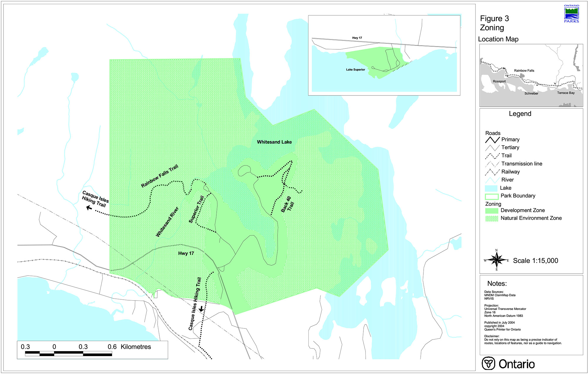
Figure 2: Adjacent Landuse, Rainbow Falls Park
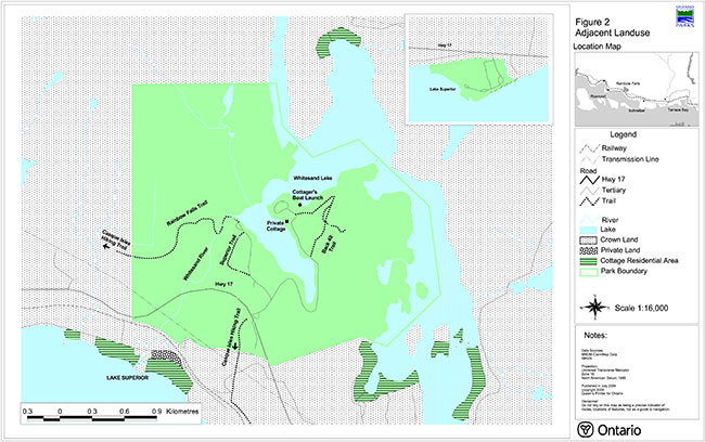
Enlarge Figure 2: Adjacent Landuse, Rainbow Falls Park
Figure 4: Development, Rainbow Falls Park
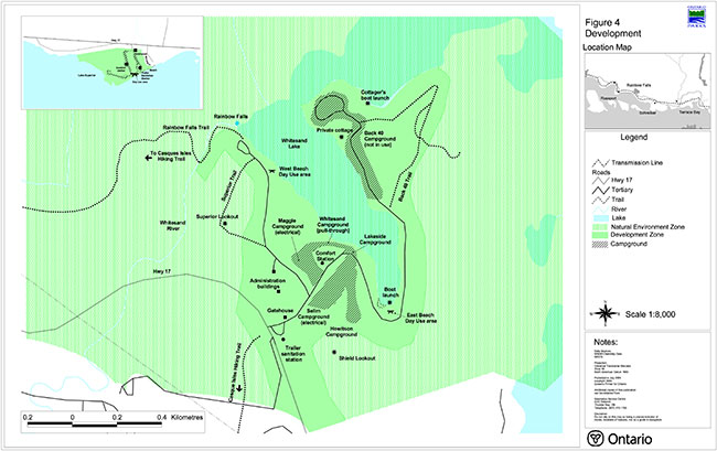
Footnotes
- footnote[1] Back to paragraph Rainbow Falls Park Management Plan has been developed in accordance with the Ontario Provincial Parks Planning and Management Policies (1992), Ontario’s Living Legacy Land Use Strategy (1999) and District Land Use Guidelines for the Ministry of Natural Resources Terrace Bay District (1983). In accordance with this plan, MNR will amend affected area-specific land use policies and mapping found in the Crown Land Use Policy Atlas
- footnote[2] Back to paragraph The Crown Land Use Policy Atlas (CLUPA) is MNR's repository of existing local land use policies for Crown lands in the central part of Ontario, including provincial parks. Amendments to the policy report of the CLUPA will be completed to reflect the direction of this park management plan.