René Brunelle Provincial Park Management Plan
This document provides policy direction for the protection, development and management of René Brunelle Provincial Park and its resources.
Ministry of Natural Resources
Ministère des Richesses naturelles
October, 1989
Approval statement
Rene Brunelle Provincial Park is situated on Remi Lake, 30 kilometers east of Kapuskasing. This recreation class park offers a wide variety of outdoor activities for local residents and tourists. Since it was established as a Provincial Park in 1957 it has become well known for its sandy beaches, large private campsites, and fishing opportunities.
We are pleased to approve the Rene Brunelle Provincial Park Management Plan, as an official policy for the management and development of this park. The plan reflects the Ministry’s intent to protect natural and cultural features of Rene Brunelle Provincial Park and to maintain and develop high quality opportunities for outdoor recreation and heritage appreciation for both residents of Ontario and visitors to the Province.
John Kéirick
Acting Regional Director,
Northern Region
Norm Richards
Director,
Parks and Recreational
Areas Branch
Additional copies of this report are obtainable from:
Ministry of Natural Resources,
Kapuskasing District Office
6-8-10 Government Road,
Kapuskasing, Ontario
P5N 2W4
3296- 1
(0.3k P.R., 89 08 31)
0-7729-4542-X
1989, Queen’s Printer for Ontario
1. Introduction
This plan provides the official policies for resource management, operation and development of René Brunelle Provincial Park. A companion document, the René Brunelle Provincial Park Management Plan Background Information, summarizes the research, which led to the development of the park policies. It is available on request from the Kapuskasing District Office. The direction and rationale for this plan were derived from the goals, objectives and strategies outlined in the Kapuskasing District Land Use Guidelines.
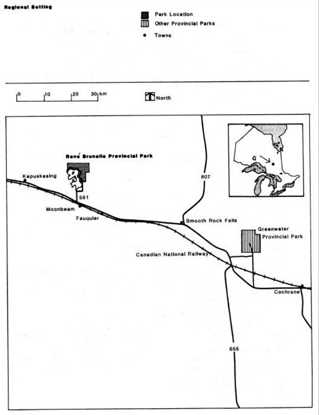
René Brunelle Provincial Park consisting of 2900 hectares, is situated thirteen kilometres north of Moonbeam, on the north and east shores of Remi Lake. Access to the Park is via secondary highway 581 (Figures 1 & 2).
In June of 1983 the Park’s name was changed from Remi Lake to René Brunelle Provincial Park. This was to honor and give recognition to the former M.P.P. and Cabinet Minister for more than twenty years service as a local member of the Provincial Parliament.
This recreation class park is located in an area of gently rolling bills covered primarily by a mixed forest of aspen, balsam fir, white birch and white spruce to flat areas covered primarily with black spruce. The modified continental climate alternates between domination by warm, humid air from the south and cool, dry air from the north. The park provides seasonal recreation for local residents and tourists with camping, swimming and picnicking.
Over the past eight operating seasons, use of the Park has declined, from a high of 16,130 camper nights in 1980 to a low of 9,558 camper nights in 1987. The July-August occupancy rate has averaged 38.6% over the same period. While camping activity as a whole has declined, the average length of stay has increased significantly from 2.2 days to 2.9 days, indication that the park is being used increasingly as a destination, rather than a stopover. During the same period, day use declined from a high of 14,345 visitors in 1980 to a low of 6, 741 visitors in 1987.
2. Significant issues
As part of an ongoing effort to improve both the efficiency and cost-effectiveness of provincial park operations, and as a result of public participation in the planning process, the Ministry has chosen to amend the park boundary to remove the winter recreation area from the park. The winter recreation area will become crown land and will be offered to the private sector on a long-term lease agreement. The removal of the winter recreation area is conditional that it must be used for the outdoor recreation purposes and a private sector operator must continue to provide alpine and Nordic skiing opportunities of equal or higher quality than the Ministry has traditionally provided.
In the event that the private sector is unable to meet the terms of the lease, the Ministry would have the right to cancel the lease and resume operation of the area as a Crown land facility.
3. Park policies
3.1 Classification
René Brunelle is classified as a recreation park in accordance with Ontario Provincial Parks - Planning and Management Policies (1978).
3.2 Park goal
To provide a variety of outdoor recreational opportunities, and to protect provincially significant natural, cultural and recreational features.
3.3 Objectives
René Brunelle Provincial Park will contribute to the achievement of the four objectives of the Provincial Parks system.
3.3.1 Recreation
To provide day-use and car camping opportunities in areas of outstanding recreation potential.
René Brunelle will provide an optimum of 43,512 camping opportunities and 50,323 day-use opportunities during the summer.
3.3.2 Heritage appreciation
To provide opportunities for exploration and appreciation of natural and cultural environment through interpretation and education.
The focus of the interpretive program at René Brunelle will be the history of the park area, with emphasis on: a) pre-historic occupations, and b) early aviation.
Figure 1: Regional Setting
3.3.3 Tourism
To provide Ontario residents and out-of-province visitors with opportunities to discover and experience the distinctive regions of the province.
Based on 1984 use levels, it is estimated that the park and its patrons contribute in the neighborhood of $546,666 worth of direct and indirect benefits to the local economy. The park, and surrounding area, are generally representative of the Great Clay Belt; and the park represents a good base of operations from which visitors can explore the surrounding area.
3.3.4 Protection
To maintain and manage the park’s environment to protect natural, cultural and recreational values. René Brunelle contains earth and life science features and archaeological sites of local and regional significance. These features will be protected through appropriate zoning and management. Features to be protected include a peatland basin, sandy beaches, and several archaeological sites.
3.4 Park area
In 1955, work started on the development of the René Brunelle (then Remi Lake) Provincial P ark, using inmates from the Monteith Correctional Centre. On June 25, 1957, the area was officially established as a Provincial Park. In 1958 the first camping and day-use areas were opened and entry and camping fees were charged. The original park boundary had included private property as well as some low swampy areas that could, not be utilized. Consequently in 1966, 2745 hectares consisting of Crown land and 3 private holdings all located north of the original park were acquired for future addition to the park. New campgrounds and day use areas were developed in the newly acquired lands and all use of the original park facilities was phased out by 1968.
In 1969, the Ontario Regulations 245/69 amended the park boundary to include the 1966 additions and also deleted approximately 146 hectares of the original park holdings.
Development of a winter recreation area started in 1968 on a 64 hectare crown land site, in 1969 and additional 51 hectares were purchased. A 1972 regulation formally annexed the 115 ha winter recreation area to the park.
In 1989, after the Park Management Plan was approved the 115 hectare Winter Recreation Area was removed from the park. The total area of the park now stands at 2900 hectares.
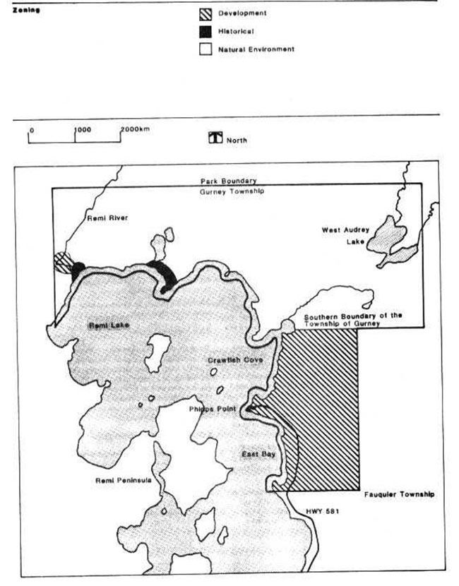
3.5 Zoning
Of the five zones possible in a recreation class park, René Brunelle Provincial Park contains three: development, historical, and natural environment (Figure 2).
3.5.1 Development zone
There are two development zones within the park. The larger of the two zones contains 605 hectares and includes all of the lands falling within Fauquier Township. The smaller zone (5 ha) is located along the Remi River in Gurney Township. Within the larger zone, actual development is limited to a fairly narrow corridor running along the Remi Lake shoreline from the park entrance to Phipps Point. This area contains 107 campsites (45 with hydro), two group campsites, two day use areas with 228 parking spaces, two nature trails, garbage depots, the woodyard and fish cleaning but, picnic shelter, trailer sanitation station, office buildings, maintenance complex and the sewage lagoon.
The small northern development zone contains two water level control dams.
3.5.2 Historical zone
There are three historical zones within the park encompassing a total area of 7 hectares. These separate zones protect archaeological sites as well as the remains of a timber camp. The Phipps Point day-use area, with its view of Airplane Island, the site of one of the earliest airbases in northeastern Ontario, is the most important historical zone to which the public have access.
3.5.3 Natural environment zone
The natural environment zone encompasses 2,283 hectares. This area represents almost the entire northern half of the park. The natural environment zone also contains representation of peatland basin, riparian basin and loam inland beach ridge environments (MacDonald, 1977). While not of provincial significance, these sites do have some interpretive potential.
Figure 2: Zoning
4. Resource management policies
The park will be managed in accordance with the general planning and management policies for recreation class provincial parks. Specific direction, where needed to meet requirements particular to René Brunelle is provided below.
Although the policies are presented in separate categories, all planning and management will recognize that the components are inter-related and that an integrated approach will be required in order for the park to achieve its objectives.
4.1 Fisheries
The current warm water sport fishery on Remi Lake will be managed in accordance with the provisions of the Kapuskasing District Fisheries Management Plan, scheduled for release in 1989/90. That plan will identify data requirements and a variety of management techniques to maintain or improve the quality of the fishery for park patrons, cottagers and the general public.
4.2 Vegetation
Vegetation in the park will be managed to fulfill protection and recreation objectives. The removal of hazard trees will continue, as will the current tree planting program. The focus of both initiatives will be the developed areas within the Development Zone. A vegetation management plan, addressing silvicultural techniques that will ensure age and species diversity, will be prepared within two years of the approval of this plan. Again, the emphasis will be on the Development Zone.
Spraying herbicides in areas other than hydro line corridors and the sewage lagoon is prohibited. The use of pathogens to control insect infestations of individual trees or stands in the Development Zone will be permitted. All spray programs will be carried out in accordance with guidelines established by the Ministries of Natural Resources and the Environment.
The Ministry of Natural Resources will extinguish all wild forest fires within the park. The Municipality of Moonbeam will extinguish all structural fires within the park.
4.3 Wildlife
A wildlife management plan for the Kapuskasing District will be completed within 5 years from the approval of this plan and will address the wildlife management need s for the park. In the meantime wildlife habitat in the park will be protected in order to increase wildlife viewing opportunities for park patrons.
Hunting is prohibited within the park boundary. Commercial trapping is also prohibited, although management trapping for the removal of nuisance beaver is permitted when required. Nuisance black bear and skunks which enter the campgrounds will be live trapped and removed from the park.
4.4 Water
The park boundary extends out into Remi Lake 150 metres along the entire shoreline within park boundary and covers approximately 202 hectares of water. Two water control dams are located in the development zone on the Remi River. The newest of the dams, built in 1968, is the only structure actually used to control the water level of Remi Lake. The older dam, built in 1953, is completely closed and has not been altered since the newer dam was constructed. Since the older dam serves no useful purpose, and is beginning to deteriorate, it will be removed.
The dams were constructed to raise the water level of the lake and provide a control mechanism to minimize seasonal water level fluctuations, thereby providing safer boating conditions and stable water levels for utilization of docks and boat camps.
Park staff manage and operate the dams with funding that originates from engineering services. The desired water level for Remi Lake is 97.60. Water level gauges are located at the dams and the Ministry of Natural Resources air base on Remi Lake.
4.5 Cultural resources
As indicated in section 3.5.2, three historical zones will be established to protect significant cultural resources. Due to the relative sensitivity of such sites, emphasis will be placed on off-site interpretation. Archaeological research will only be permitted by accredited individuals working under the authority of a valid research permit issued by the District Manager, Kapuskasing.
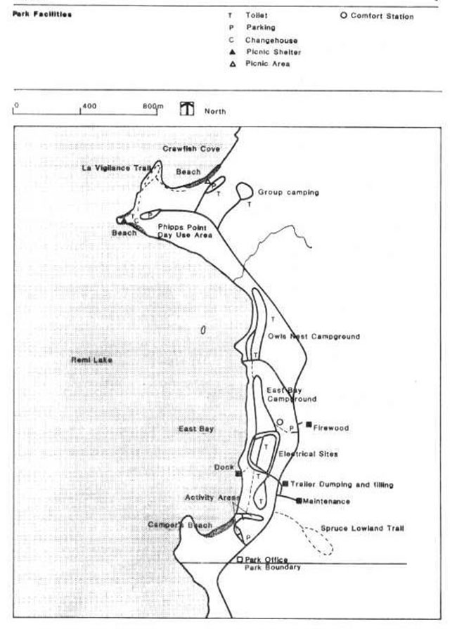
Figure 3: Park Facilities
5. Operations policies
5.1 Visitor services
At present, the visitor services program is based primarily on self-use facilities. This is in accordance with the regional visitor services plan which was prepared in 1987. A re-evaluation of the park’s role in the regional visitor services plan is currently underway. Considerations such as level of service, program emphasis and level of staffing are being reviewed. The park’s visitor services and marketing plans will be designed to compliment corresponding regional plans and will be prepared within two years of the approval of this plan.
5.1.1 Information
Information on the park and surrounding area will be provided by all park staff, particularly those working at the gatehouse. Park publications and exhibits will rely on self-use formats. General information about the surrounding area will be available at the gatehouse. A display board will be erected at Phipps Point, trail guides and park brochures will be updated. All publications will be printed in English and French and personal service to the public will also be available in both languages.
5.1.2 Interpretation
Major themes to be interpreted will include pre-contact aboriginal occupations, the park’s connection with early aviation, and forest operations at the nearby Edward Bonner Tree Improvement Centre. Program emphasis will be in the historic and natural environment zones, with corresponding displays in the development zone. Park users will be encouraged to visit nearby Bonner Tree Improvement Centre.
5.1.3 Recreation
The aim of the recreation component of the program at René Brunelle is to provide the best information about recreational opportunities in the park and the surrounding local area. Programs devoted to boating skills, water safety, and other activities appropriate to the park’s resource base, will be provided on an intermittent basis.
5.2 Marketing
The park’s existing marketing plan is geared towards encouraging increased visitation. The park’s proximity to Highway 11, a major travel corridor in Northeastern Ontario; and to Kapuskasing, one of the large urban areas in the region, make it a candidate to serve the needs of both residents and the travelling public.
A study of user statistics for the park was conducted for the period from 1984 to 1987, in order to provide background for the new marketing plan. During that period, day-use and camping declined by 37% and 17% respectively. The downward trend in camping activities is probably attributed to increases in supply provided by two private campgrounds on Remi Lake, both of which offer seasonal camping. The decline in day-use is probably a result of recent improvements to the Town of Kapuskasing Municipal Park on Clear Lake, some 25 km closer to Kapuskasing than the park, and significant increases in day use fees.
Campers origins during the 1984-1987 period have remained relatively constant, with roughly 38% being local, 42% from elsewhere in Ontario, 10% from other provinces, and 10% from the U.S. and overseas.
The park will continue to provide information regarding public and private sector services and attractions in the area. A new marketing plan, consistent with the provincial guidelines approved in 1986, will be prepared within two years of the approval of this plan. It will continue to encourage increases in local camping and day-use activity. The plan will also provide direction for the promotion of the park at key locations within the Province, as well as at provincial sports and trade shows. It will be reviewed annually and updated as required.
5.3 General
A park Operating Plan will provide park staff with the necessary direction required to operate the park on a day-to-day basis, and will include such topics as budget, maintenance schedules, security and enforcement, and emergency services. The provisions of the plan will be consistent with the approved Ontario Provincial Parks Operating Standards, and will ensure that the park is operated to meet or exceed the minimum standards. It will be reviewed annually and updated as required.
6. Development
Future capital development will occur in phases, and only in response to demonstrated demand, subject to availability of funding. In all instances detailed site plans will be completed and internally approved in advance of new development or the renovations of existing facilities.
A number of facilities at René Brunelle are approaching their expected life span or have become outdated and must be upgraded over the next few years. Facilities falling into this category include the water system, several vault toilets, comfort stations and campsite roads.
During the consultation process there was strong support from the public for new capital development and upgrading of existing facilities. The future capital development and upgrading phasing is listed in order of priority and is responsive to public input and health and safety considerations.
6.1 Phasing
Phase I
- Priority 1 - upgrade water system - installation of filter system, replacement of pumps and 2 km of waterline
- Priority 2 - install electricity to 30 campsites in East Bay campground
- Priority 3 - install children’s play structure in East Bay campground
- Priority 4- construct boat launch ramp and additional docking facilities in East Bay campground
- Priority 5 - complete surface treatment of roads- 3 km of one way campsite roads
Phase II
- Priority 1 - upgrade group camping area Priority 2 - replace 2 sets of vault toilets
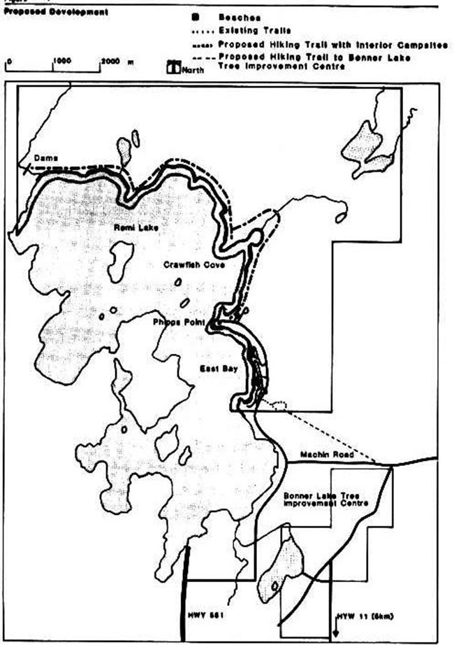
- Priority 3 - renovations of Spruce Lowland and La Vigilance Trails
- Priority 4 - construct recreation trail to Remi River and survey area for interior camping
- Priority 5 - conduct feasibility survey for trail to Edward Bonner Tree Improvement Centre
- Priority 6 - construct visitor services activity centre
- Priority 7 - construct outdoor recreation facilities - i.e. softball field, volleyball courts, children’s playground
Phase III
- Priority 1 - construct 10 interior campsites on Remi River Trail
- Priority 2 - construct trail to Bonner Centre if feasible
- Priority 3 - replace comfort station
7. Summary of public consultation
7.1 Public notice
The Preliminary Management Plan was presented to the Kapuskasing District Fish & Wildlife Advisory Committee on February 2/88.
The Preliminary Plan was distributed via mailing list to interested parties and agencies on February 9/88.
The Preliminary Plan was presented to the Kapuskasing Chamber of Commerce on February 17/88.
An information centre was held on February 25/88 at the Model City Mall, Kapuskasing.
Public Notice of information centre released to local media via news release and paid advertisements February 17.
Copies of the Preliminary Plan were available to the public at the district office and winter recreation area up to March 25/88.
7.2 Summary of major issues
The major issue addressed in the preliminary plan was the boundary amendment to remove the winter recreation area from the park. Public reaction to this was split with one-third of respondents in favor and two-thirds opposing the concept. Those in favor including four local municipalities, consider the private sector could do a better job managing the area. Opposition to the concept centered around fear of increased user fees and ability of private sector to turn a profit in operating area.
Figure 4: Proposed Development
8. Implementation strategy
The preceding policy statements will be implemented with the formal approval of the management plan, and allocation of necessary funds.
The Vegetation Management Plan and Marketing Plan for the park will be completed by December 31, 1990. The park operating plan will be completed by June 20, 1989.
The management plan will be subject to a full, scheduled review not less than once every ten years following its approval. Minor amendments to the plan may be made in the interim. Any proposed amendments which potentially could have a major impact on park management policies will require a full public review.
References
Bramm, R.G., Glew, J.R., Earth Science Report. Ontario Ministry of Natural Resources, Park Planning Branch Environmental Section, unpublished report, 1974..
Crowe, R.B., Baker, W.M., McKay, IA. The Tourist and Outdoor Recreation Climate of Ontario. Vols. II.
III., Meteorological Applications Branch, Ministry of Industry and Tourism, 1979.
Frey, E., Personal Communication, Re: Significant Geological Features, Ontario Ministry of Natural Resources, District Planner, Wawa, 1981.
Heidenheim, M., Background Information Package for Kabuskasing District L.U.P. 1980
MacDonald, I.D, Life Science Inventory Sheet for Remi Lake Provincial Park Preliminary Draft.
Ontario Ministry of Natural Resources, unpublished report, 1974.
Ontario Ministry of Natural Resources, Kapuskasing District Land Use Guidelines. 1983.
Ontario Ministry of Natural Resources, Lake Plan for
Remi Lake First Draft unpublished report, 1974.
Ontario Ministry of Natural Resources, Remi Lake Provincial Park Marketing Plan. 1980
Ontario Ministry of Natural Resources, Remi Lake Task Force Report unpublished report, 1975. Pendergest, J., Historical Sites Branch, Ontario Ministry of Natural Resources, unpublished report, 1974.
Pollock, J., Native Historical Report, Algonquin Culture Development and Archaeological Sequences in Northeastern Ontario Ministry of Culture. and Recreation, unpublished report, 1976.
Pollock, J., Remi Lake Prehistory, An Archaeological Outline. Ontario Ministry of Natural Resources, unpublished report, 1975..
Sangster, PJ., Bedrock Mineral Potential, and Aggregate Potential of Fauquier and Nansen Townships Ontario Ministry of Natural Resources.