River Aux Sables Provincial Park Management Statement
This document provides policy direction for the protection, development and management of River Aux Sables Provincial Park and its resources.
Interim Management Statement
2006
Approval statement
I am pleased to approve this Interim Management Statement for River aux Sables Provincial Park. Ontario’s Living Legacy Land Use Strategy (OMNR 1999) designated this area as a waterway class provincial park.
This Interim Management Statement provides direction for the protection and custodial management of River aux Sables Provincial Park. This park is not yet regulated.
Signed by:
Paul Bewick
Zone Manager
Northeast Zone
Ontario Parks
Date: June 12, 2006
1.0 Introduction
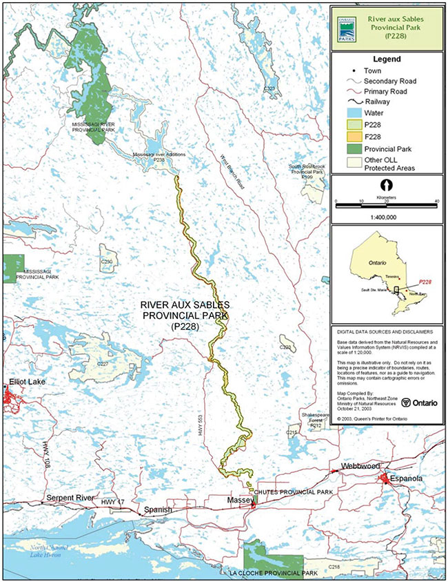
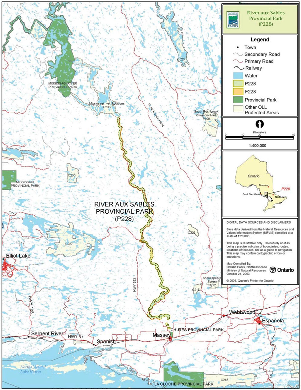
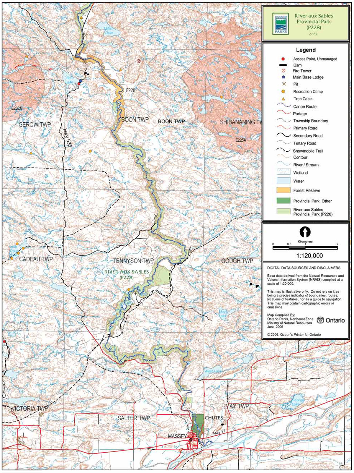
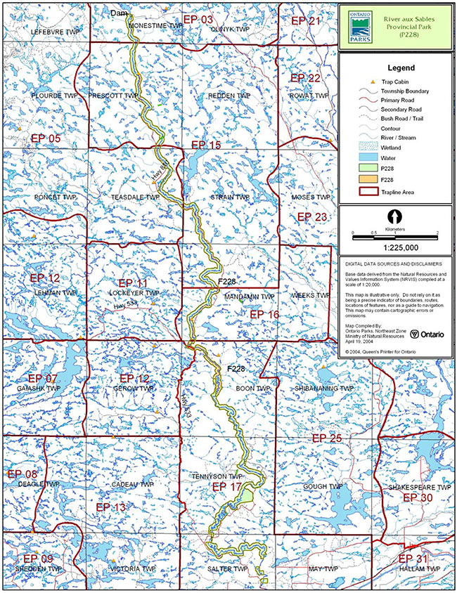
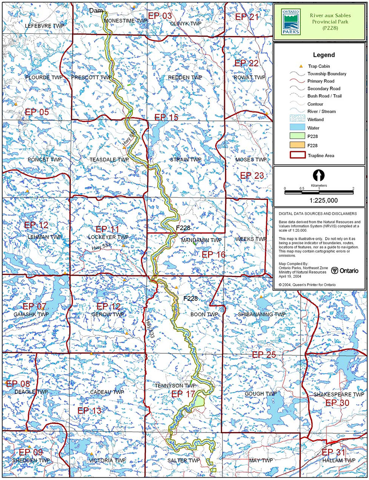
River aux Sables Provincial Park is located in Tennyson, Mandamin, Boon, Salter, Teasdale, Prescott, Strain, and Monestine townships (Figure 1). This waterway class park protects approximately 3,658 hectares including 75 kilometres of the river. The purpose of the waterway designation within the context of the provincial park system is to protect outstanding recreational water routes and is meant to provide high quality recreational and educational opportunities.
The park’s northern boundary abuts the Mississagi River Addition (P238) at Ritchie Falls. The southern boundary of this park is fragmented and the most southern block of the park is located just north of Chutes Provincial Park (Figures 2a and 2b).
1.1 Objectives
The park will be managed consistent with the four objectives for provincial parks:
Protection: To protect provincially significant elements of the natural and cultural landscapes of Ontario.
Recreation: To provide provincial park outdoor recreation opportunities ranging from high-intensity day-use to low-intensity wilderness experiences.
Heritage Appreciation: To provide opportunities for exploration and appreciation of the outdoor natural and cultural heritage of Ontario.
Tourism: To provide Ontario’s residents and out-of-province visitors with opportunities to discover and experience the distinctive regions of the Province.
2.0 Management context
The purpose of this Interim Management Statement (IMS) is to provide direction to ensure the custodial management of park resources. Future park planning may be undertaken as required to provide direction on significant decisions regarding resource stewardship, development, operations and permitted uses.
Park management will follow direction from:
- Provincial Parks Act (1990) and regulations
- Ontario Provincial Parks Planning and Management Policies (OMNR 1992)
- Crown Land Use Policy Atlas (OMNR 2004a)
- Ontario’s Living Legacy Land Use Strategy (OMNR 1999) and policy clarification amendments (OMNR 2000) and related direction
In addressing custodial management obligations to protect park values and ensure public health and safety, Ontario Parks will ensure that policy and Environmental Assessment Act (1990) requirements are implemented.
Figure 1: Regional Context, River aux Sables Provincial Park
Enlarge Figure 1: Regional Context, River aux Sables Provincial Park
Figure 2a: Park Boundary, River aux Sables Provincial Park
Enlarge Figure 2a: Park Boundary, River aux Sables Provincial Park
Figure 2b: Park Boundary, River aux Sables Provincial Park
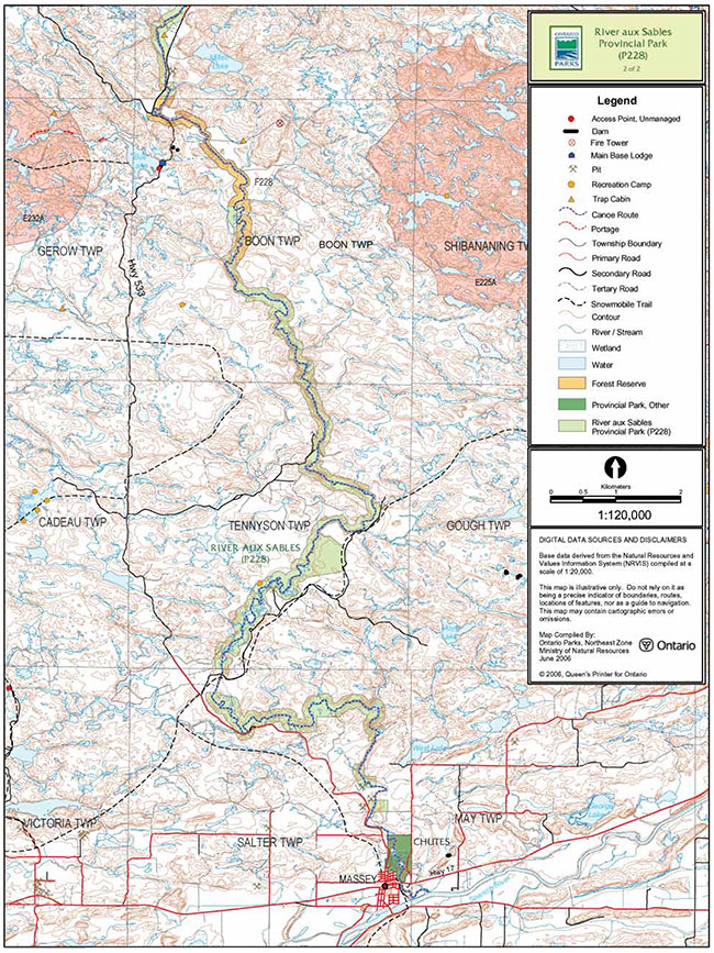
Enlarge Figure 2b: Park Boundary, River aux Sables Provincial Park
2.1 Environmental assessment
As a part of the Ontario Ministry of Natural Resources (MNR), Ontario Parks is a public sector agency that is subject to the Environmental Assessment Act. Park management will be carried out in accordance with legislation, policies and guidelines that are required under MNR's A Class Environmental Assessment for Provincial Parks and Conservation Reserves (OMNR 2005a).
3.0 Park features and values
The River aux Sables originates at Lac aux Sables and flows for 85 kilometres through Ecodistricts 4E-3 and 5E-4 south to Chutes Provincial Park.
This river has free-flowing drainage and impressive white water sections. The natural corridor provides accessible paddling opportunities that are directly linked to an existing park (Chutes Provincial Park). The southern portion of the river is renowned for white-water kayaking.
3.1 Geological features
The park’s dominant bedrock types are felsic to intermediate metaplutonic rocks of the Ramsey Algoma granitoid complex and subordinate Paleoproterozoic mafic metaplutonic rocks, components of the south-central Abitibi Subprovince in the Archean Superior Province (Frey and Duba 2002).
The Quaternary glacial deposits of the park are late Wisconsinan in age. The northern and central portions of the park are covered by outwash fine sand, sand, and gravel, as well as glaciolacustrine deposits of deltaic sand. The southern segment of the river is overlain by silty to sandy till and glaciolacustrine deposits or varved or massive clay to silt and fine sand (Frey and Duba 2002).
Within the Ontario Parks system, the bedrock geological features of this park have regional significance in representing the Ramsey-Algoma granitoid complex and components of the south- central Abitibi Subprovince in the Archean Superior Province (Frey and Duba 2002).
3.2 Biological features
River aux Sables Provincial Park starts in Ecodistrict 4E-3 at Ritchie Falls and extends southward into Ecodistrict 5E-4. The river continues south through Chutes Provincial Park and the town of Massey, before joining the lower Spanish River.
The river supports both cold water and warm water fish species, but is better known for its cold water species (brook trout) (Morris 2003).
The most significant natural heritage area within the park is the riparian wetland in Tennyson Township. This area was found to have a wide range of aquatic and marsh vegetation, as well as a complex arrangement of oxbow swale ponds and abandoned river channels which attract migratory and breeding marsh birds and waterfowl. Although it provides good representation of this community type, the surrounding areas have been logged and replanted with pine species (Morris 2003).
The 200 metre terrestrial corridor provides local protection to the River Aux Sables watershed. Parts of the park include floodplains, such as the Tennyson Township riparian wetlands (Morris 2003).
This park is regionally significant for its representation of a medium-sized river and corridor of Ecodistricts 4E-3 and 5E-4 (Morris 2003).
3.3 Cultural setting
An investigation into the cultural features specific to River aux Sables Provincial Park has not been completed at this time.
Any future planning will be within the context of a provincial framework, A Topical Organization of Ontario History (OMNR 1974). In addition, updates and discussions with First Nations, other agencies and stakeholders may be carried out to identify cultural heritage values and features within the park and their significance. This information may be used to develop management guidelines to conserve and protect representative archaeological and historical values and features, or to provide direction for further research.
3.4 Recreation
River aux Sables is a documented canoe route and experiences use by canoeists and kayakers. The river offers flatwater portions and challenging white water sections. The lower section of the river, a portion of which is included in the park, is recognized as one of the best white water kayaking destinations on the North Shore. This Class III to Class IV river is recommended for experienced paddlers only, as it contains several sections of challenging white water (Harper 2003).
The park area is also a popular fishing, hunting, and camping destination (Harper 2003).
4.0 Aboriginal uses
River aux Sables Provincial Park is located within the Robinson – Huron Treaty (1850) approximately 20 kilometres north of the Sagamok Indian Reserve.
First Nations have expressed interest in and have shared knowledge of the park and surrounding area. Aboriginal communities have used the area for hunting, trapping, fishing, gathering and travel. These uses may continue, subject to public safety, conservation and other considerations.
Any communications and cooperation between Aboriginal communities and the MNR for planning and operations purposes will be done without prejudice to any future discussions or negotiations between the government of Ontario and Aboriginal communities.
5.0 Stewardship policies
Removal, damaging or defacing of Crown property, natural objects, relics and artifacts is not permitted in provincial parks (Provincial Parks Act).
Alternative non-commercial energy proposals (e.g. small scale hydro, wind and solar) for in-park use may be evaluated through future park planning, including full public and Aboriginal consultation.
5.1 Terrestrial ecosystems
5.1.1 Vegetation
Harvesting
Commercial forest harvesting and renewal activities are not permitted within the park (OMNR 2004a).
The harvest of non-timber forest products such as club moss, Canada yew etc., will not be permitted within the park.
Existing authorized wild rice harvesting may continue. New operations will not be permitted.
There are no fuelwood cutting permits currently issued for the park. No new permits will be issued (OMNR 2000).
Non-native plants
Non-native plant species will not be deliberately introduced into the park. Where non-native plant species are already established, and threaten park values, a strategy may be developed to control the species (OMNR 1992).
Insects and disease
Insects and diseases may be managed where the park’s aesthetic, cultural or natural values are threatened (OMNR 1992).
Control measures will follow guidelines established by the Ontario Ministry of the Environment (MOE) and the MNR. Biological controls, in preference to chemicals, will be used whenever possible (OMNR 1992).
Fire
The park is located within MNR's Great Lakes - St. Lawrence Fire Management Zone. In accordance with existing provincial park policy and the Forest Fire Management Strategy for Ontario (OMNR 2004b), forest fire protection will be carried out in River aux Sables Provincial Park as on surrounding lands.
Whenever feasible, MNR's Forest Fire Management program will use techniques which minimize damage to the landscape, such as limiting the use of heavy equipment or limiting the number of trees felled during response efforts (OMNR 2004b).
5.1.2 Wildlife management
River aux Sables Provincial Park is located within Wildlife Management Units 37 and 38. Removal or harassment of non-game animals is not permitted in provincial parks (Provincial Parks Act).
Hunting
Sport hunting is permitted to continue. Considerations of safety and conservation with respect to hunting may be made through future management planning, which includes public consultation (OMNR 2000).
The Fish and Wildlife Conservation Act (1999) and the Migratory Birds Convention Act (1994) govern hunting within the park. The Ontario Hunting Regulations Summary contains regulations specific to this area. The harvest of bullfrogs or snapping turtles is illegal in provincial parks.
Bear Management Areas
The park includes portions of seven licensed bear management areas (BMA): EP37-039, EP37-040, EP37-045, EP37-048, EP38-065, EP38-074, and EP38-078 (Figure 3).
Existing commercial bear hunting operations are permitted to continue. This activity may be subject to conditions identified during future management planning (e.g. the designation of nature reserve zones).
New BMA licences will not be permitted (OMNR 2000; 2003).
Figure 3: Bear Management Areas, River aux Sables Provincial Park
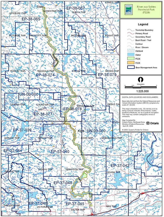
Enlarge Figure 3: Bear Management Areas, River aux Sables Provincial Park
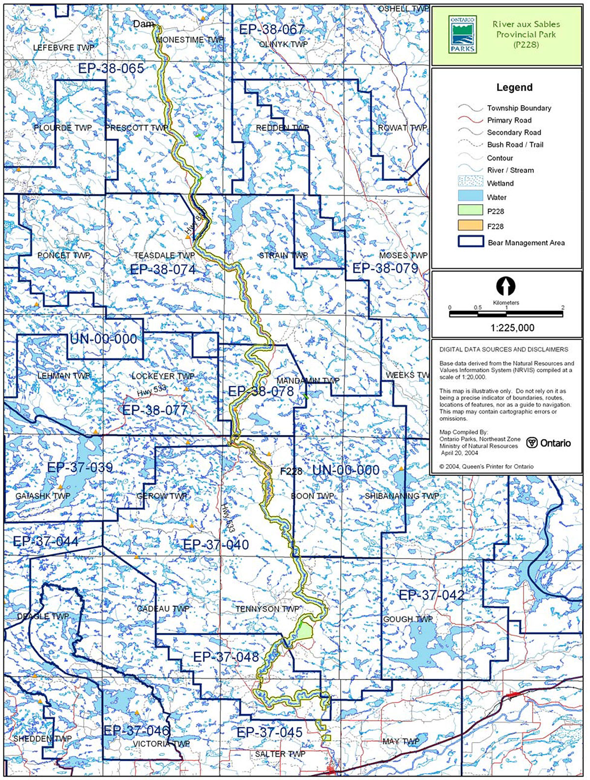
Trapping
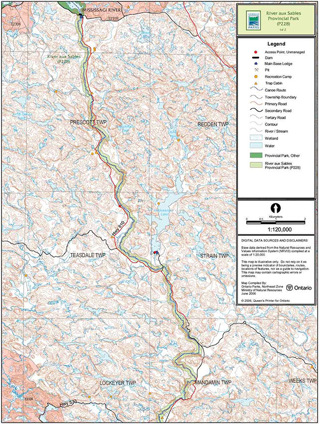
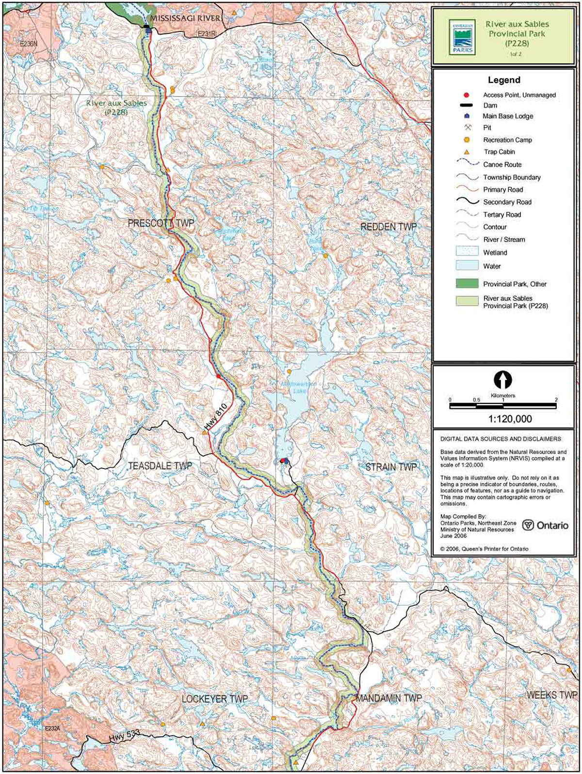
There are portions of six licensed trap lines within River aux Sables Provincial Park: EP-03, EP-05, EP-12, EP-15, EP-16, and EP-17 (Figure 4). There are also two trap cabins (EP-15 and EP- 16) located within the park boundary.
Existing commercial fur harvesting operations may continue where the activity has been licensed or permitted since January 1, 1992. New operations, including trap cabins and trails, will not be permitted (OMNR 2000; 2003).
Transfers of active trap line licenses are permitted, subject to a review of potential impacts and the normal transfer or renewal conditions that apply.
5.1.3 Industrial resources
Aggregate extraction is not a permitted use within provincial parks (OMNR 1992; 2004a). However, the current unregulated park boundary includes portions of active aggregate permits as well as several inactive aggregate pits. The existing active aggregate permits may continue as a non-conforming use within the park.
There are no existing mining claims within the park boundary and lands have been withdrawn from mining activity under the Mining Act (1990). Mineral exploration and mining are not permitted within the park (OMNR 1992).
In accordance with Ontario’s Living Legacy Land Use Strategy, access through the park to mining lands beyond the boundary (i.e. forest reserves and mining patents) will be permitted for purposes of mineral exploration, development or operations. Access will be planned in accordance with the requirements of the Environmental Assessment Act.
5.1.4 Access and crossings
Access
This waterway park is accessible through a number of primary, secondary, and forestry roads as well as by water and air.
Roads
Highway 553/810 (Massey Tote Road) travels north from Massey to Ritchie Falls. The road parallels the river in many places and crosses the river in three locations in Prescott, Strain and Mandamin townships. Highway 553 ends at East Bull Lake and continues north as Highway 810. The highway corridor is excluded from the park boundary.
Existing roads that have been identified for long term use by the forest industry will continue to be available. These include:
- Highway553/810
- Eight Mile Road
- Boon Road
- 12 Mile Road
- Crossover Road
- Whiskey Lake Road
- Madawason Lake Access Road
- Plaunts Road
- Ritchie Falls Road.
Existing and future tertiary roads associated with the above roads that are required to access forest allocations adjacent to the park are permitted. Tertiary roads will be constructed to a minimum standard and physical abandonment will occur once the road is no longer required. Future tertiary roads that travel through the park boundary will be addressed during forest management planning, and park values will be a priority.
Figure 4: Trap Line Areas, River aux Sables Provincial Park
Enlarge Figure 4: Trap Line Areas, River aux Sables Provincial Park
Where existing access roads are essential for continued access within or beyond the park for forest management, recreation or in-holdings (i.e. land use permits, patent land, etc.) and alternative road access does not exist, or road relocation is not feasible, existing roads will continue to be available for access. Continued use will include maintenance and may include upgrading (OMNR 2004a). Ontario Parks is not responsible for maintenance or upgrading of any existing roads within the park boundary.
Crossing of waterway parks by new roads may be necessary. The number of crossings will be minimized where possible and managed to reduce their impact on recreational and aesthetic values. Any future road crossings proposed through the park, where park lands are unavoidable, will be reviewed on a case-by-case basis. Protection of park values will be a priority and all requirements of the Environmental Assessment Act will be met.
Aggregate extraction is not permitted within parks. An external source of aggregate is required for road improvements and maintenance.
Utility corridors
There are two hydro line corridor crossings in the park; the Hydro One corridor crosses the park in Boon Township and a private power line in Salter Township.
Maintenance of existing utility lines will be permitted. Maintenance activities shall not impact negatively on park values and must adhere to the regulations set out under the relevant acts, such as the Environmental Assessment Act, the Canadian Environmental Protection Act (1999), and the Pesticides Act (1990).
All public utilities (e.g. gas pipelines, transmission lines, communications towers, etc.) must avoid park lands wherever possible, however new utility corridor crossings may be necessary to maintain essential public services (OMNR 2004a).
Any future utility corridors proposed through the park, where park lands are unavoidable, will be reviewed on a case-by-case basis. Protection of park values will be priority and MNR's environmental assessment requirements must be met.
Recreational trails
Canoe Routes: The River aux Sables is a documented canoe route. This Class III to Class IV river is recommended for experienced paddlers only, as it contains several sections of challenging white water (Harper 2003).
Snowmobile Trails: The Ontario Federation of Snowmobile Clubs (OFSC) Trans Ontario Provincial Series (TOPS) trail "D" crosses through the park boundary in Salter Township just south of Cameron Falls. The Algoma Snow Plan Affiliation (ASPA) maintains this OFSC TOPS trail as part of their local trail system.
Hiking Trails: There are no designated hiking trails in River aux Sables Provincial Park at this time. There are however some trails which run adjacent to the park.
All-Terrain Vehicle Trails: There are no designated all-terrain vehicle (ATV) trails in River aux Sables Provincial Park at this time.
New trails (e.g. hiking) may be developed if the need arises. Any proposed development within the park is subject to Environmental Assessment Act requirements.
5.1.5 Adjacent land management
Forestry
The land adjacent to this park is included in the Spanish Forest (#210) and the North Shore Forest (#680) management areas. The Spanish Forest is currently managed by Domtar Incorporated and the North Shore Forest by Northshore Forest Incorporated. Forest Management Plans for both of these areas are scheduled for renewal in 2010.
Provincial parks
Chutes Provincial Park (108 hectares) is located south of this park and was designated under the Provincial Parks Act in 1970.
Mississagi River Park Additions (P238) is located north of this park. The additions add 67,253 hectares to the existing Mississagi River Provincial Park.
Forest reserves
Forest reserves (FR) are areas where the protection of natural heritage and special landscapes is a priority, but some resource use can take place under the appropriate conditions. Policies for FRs are similar to the policies for new conservation reserves, except that mining and related activities will be allowed in a forest reserve. Commercial forest harvest, new hydroelectric power development, and peat extraction will not be allowed, but most other resource and recreation uses will be permitted, provided that they are consistent with the features and values being protected (OMNR 1999).
There is one forest reserve (F228) located adjacent to the boundary of this park. This forest reserve, which is 309 hectares in size, includes two linear mining parcels with river sections that connect with this park (OMNR 2004a). As described in the proposed strategy for FRs (OMNR 2005b), the FR designation will be retained and the FR may eventually be added to the park.
General use areas
There are three General Use Areas adjacent to River aux Sables Provincial Park: The West Branch (G2035), Lower Massey Tote Road (G2034) and The Rural Settlements (G2025).
The West Branch General Use Area (G2035) is a 205,954 hectare area located adjacent to the northern half of the park. This large area includes a majority of the Crown land base of the Espanola District. The primary purpose for this area is economic resource development, in particular logging and commercial tourism.
Lower Massy Tote Road General Use Area (G2034) is a 52,226 hectare area located adjacent to the central length of River aux Sables Provincial Park. Commercial and industrial activities such as tourism, mining and forestry are supported.
The Rural Settlements General Use Area (G2025) is a 282,230 hectare area located along the southern section of River aux Sables Provincial Park. The purpose of this area is to recognize and support the existing activities in the settled, rural areas of the district.
5.1.6 Land disposition
River aux Sables Provincial Park is located in the Sudbury District of the MNR. The park travels through eight townships as it flows from just south of the Mississagi River Park Additions (P238) to just north of Chutes Provincial Park.
No new land disposition for private use or corporations will be permitted within the park boundaries (OMNR 2004a).
Land Use Permits, Licenses of occupation, unauthorized occupations
There are two private recreation camp land use permits (LUPs) located within the boundary of the park. These permits are located in Tennyson and Prescott Townships. These LUPs are permitted to continue. There will be no new dispositions for private recreation camps (OMNR 1999).
Existing authorized LUPs for recreation camps may be eligible for enhanced tenure but not the purchase of land. Recreational camp LUPs cannot be changed to commercial LUPs unless this is supported during a review as part of park management planning. Enhanced tenure, is defined as a possible extension of the term of the LUP for recreation camps up to 10 years or upgrade in tenure (i.e. LUP to lease) (OMNR 2000a).
Enhanced tenure for an LUP for a recreation camp is not guaranteed. Requests for enhanced tenure, or to transfer recreation camps, will be reviewed based upon the following criteria:
- Continued compliance with the conditions of the LUP for recreation camps
- Current land disposition policies for LUPs
- Consistency with park objectives to sustain values – no effects on heritage values and/or conflict with other uses
- Consistency with Aboriginal land claim negotiations or protocol agreements
- All rents, taxes, fees, rates or charges are paid and in good standing
An extension in the term of tenure for an existing private recreation camp LUP does not convey a commitment to provide for a change in the type or the standard of existing access to the private recreation camp.
An existing private recreation camp LUP holder can relinquish their LUP and are responsible for having existing improvements removed including, but not limited to, the sale of any existing improvements. The MNR may consider purchase of improvements.
Patent land
There are no parcels of patent land surrounded by the park. The policies that are applied to this park do not affect the uses of adjacent patent land.
Private land is not included within the park boundary and as such park policy does not apply to these areas.
Boat caches
There are no authorized boat caches within the boundary of River aux Sables Provincial Park.
Boats are not permitted to be left unattended in the park without written permission from the park superintendent under the authority of the Provincial Parks Act.
5.2 Aquatic ecosystems
Sustaining quality water resources is integral to the protection of park and adjacent lands values. The MOE enforces applicable legislation and regulations for water quality.
5.2.1 Water management
The Aux Sables Watershed Water Management Plan, a simplified water management plan, provides overall direction for watershed water management (OMNR 2004a). The emphasis on management of the watershed is optimizing the benefits for protection of aquatic resources and recreational and industrial users.
There are no water control, hydro electric, or diversion structures located within the boundary of the park. No new commercial hydroelectric developments will be permitted in River aux Sables Provincial Park (OMNR 2000).
The Cameron Falls Generating Station (Tennyson Township) is located on private land not within the park boundary.
There is a Memorandum of Understanding between the MNR and the owner of Ritchie Falls Resort for the operation of the Ritchie Falls Dam and Micro-Hydro Facility. This dam is located just north of the northern park boundary.
5.2.2 Fisheries management
Fisheries management will complement the maintenance and enhancement of native, self-sustaining fish populations (OMNR 1992).
Sport fishing
Sport fishing is permitted within the park. This activity is governed by legislation and regulations in the Fish and Wildlife Conservation Act and the Fisheries Act (1985). The Recreational Fishing Regulations Summary contains details on the regulations that are applicable to this area.
Commercial fishing
There are no commercial fishing operations within the boundary of River aux Sables Provincial Park. New operations will not be permitted (OMNR 2004a).
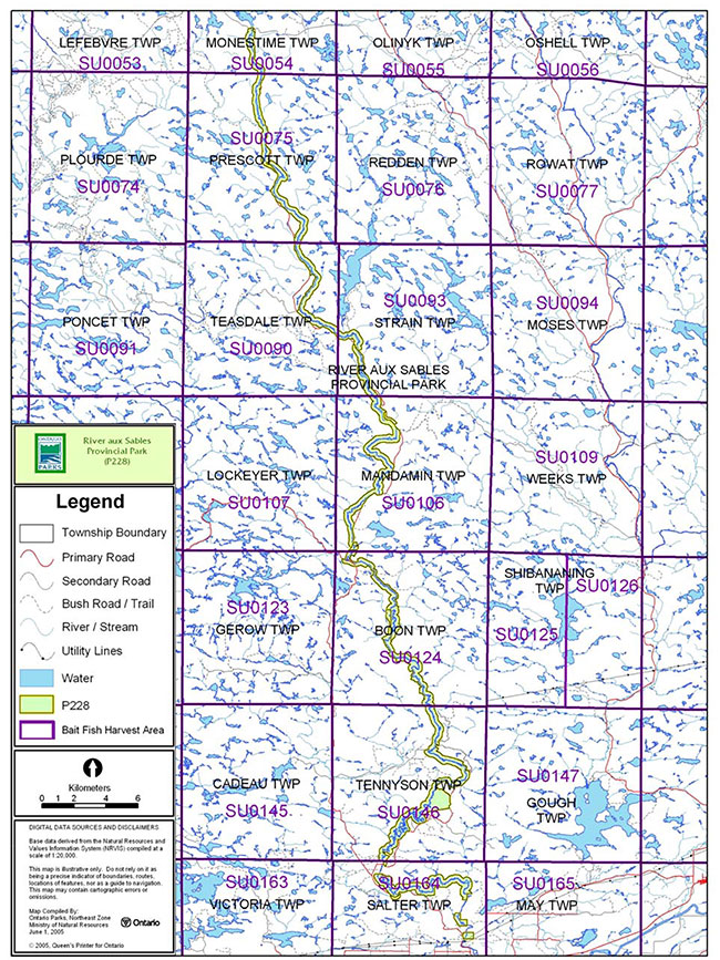
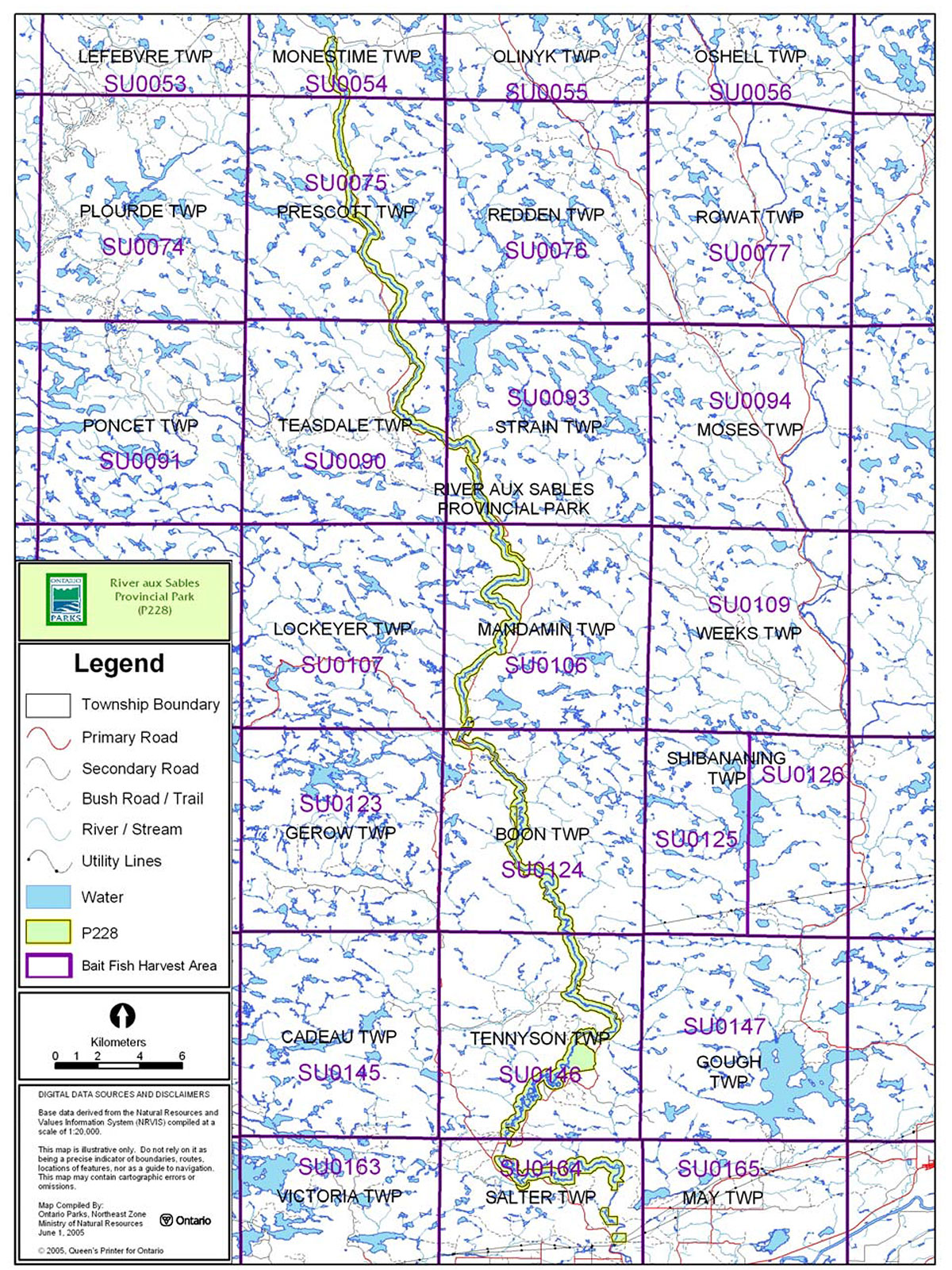
Commercial baitfish harvesting
Mandamin, Boon, Salter, Tennyson, Teasdale, Prescott, Strain and Monestine townships are currently allocated for baitfish harvesting.
Existing commercial baitfish harvesting may continue where the activity has been licensed or permitted since January 1, 1992. This activity may be subject to conditions identified through future park management planning or fisheries management plans. New baitfish licenses will not be permitted (OMNR 2000; 2003).
Fish stocking
The stocking of native fish species may be considered through park management planning, with full public consultation. Non-native fish species will not be deliberately introduced into park waters (OMNR 1992).
6.0 Operations policies
6.1 Recreation management
Future planning, with full public consultation, will review direction on motorized and non-motorized recreation uses.
6.1.1 Motorized recreation
Motorboats
The use of motorboats is permitted to continue, unless park values are being threatened (OMNR 2004a).
Figure 5: Commercial Baitfish Harvesting, River aux Sables Provincial Park
Enlarge Figure 5: Commercial Baitfish Harvesting, River aux Sables Provincial Park
Snowmobiles
There is one existing OFSC snowmobile trail located in this park.
The use of existing snowmobile trails is permitted to continue unless park features are threatened. Proposals for new trails may only be considered through future planning with public consultation (OMNR 2000).
Off-trail snowmobile use is not permitted within the park.
All-terrain vehicles
There are no authorized ATV trails located within the boundary of the park. These vehicles may be using the existing road network as unauthorized trails. Proposals for new trails may only be considered through future planning with public consultation (OMNR 2000).
Off-road use of ATVs will not be permitted within park boundaries unless authorized by the park superintendent under the authority of the Provincial Parks Act .
Aircraft
Aircraft landings are permitted in this waterway park (OMNR 2004a). All aircraft landings are subject to regulation and valid aircraft landing permits issued by the park superintendent under the authority of the Provincial Parks Act.
6.1.2 Non-motorized recreation
Camping
There are currently no developed camping facilities within River aux Sables Provincial Park. There are, however, several unmanaged campsites within the park boundary associated with the canoe route and road access within the park.
Ontario Parks may assess the condition of existing campsites and will maintain, rehabilitate or close sites as required. If there is an identified need, new backcountry campsites may be considered (OMNR 2004a). Infrastructure will be permitted in order to protect park features and values in response to use, environmental deterioration and environmental protection requirements. Any proposed development in the park must fulfill the requirements of the Environmental Assessment Act.
Hiking
There are no authorized hiking trails within the boundaries of this provincial park.
Existing hiking trails may be permitted to continue unless such trails threaten park features and values, create user conflicts or raise safety/liability issues.
If there is an identified need, the development of new hiking trails may be considered. Trail infrastructure to protect park values and features will be permitted. Any proposed development within the park is subject to Environmental Assessment Act requirements.
Canoeing/kayaking
Existing uses may continue, unless park values are threatened (OMNR 2004). Infrastructure to protect park features and values may be permitted and developed in response to use, environmental deterioration and environmental protection requirements.
6.1.3 Emerging recreation uses
There are emerging recreation uses for which there is limited or no policy to deal with their management (e.g. adventure racing, geocaching). The park superintendent will use legislation, policy and guidelines that are in place in the interim to manage emerging uses.
6.2 Development
There is no existing park infrastructure located within the park boundary. Infrastructure to protect park features and values may be permitted and developed in response to use, environmental deterioration and environmental protection requirements. Any proposed development within the park is subject to MNR's requirements under the Environmental Assessment Act.
6.3 Commercial tourism
There are currently no commercial tourism facilities located within the park boundary.
New commercial tourism facilities may be considered where consistent with park policy (OMNR 2004a). Any development must meet the requirements of the Environmental Assessment Act.
7.0 Cultural resources
No assessment of the cultural resources specific to River aux Sables Provincial Park has been completed at this time; however, management of any cultural values within this park will be directed toward protection and heritage appreciation (OMNR 1992).
8.0 Heritage education
Literature and other supporting information may be developed to describe the park in the context of Ontario’s provincial park system. Boundary limits, significant heritage features and permitted uses of the waterway park may be included in park literature.
Prospective park visitors may be informed about the sensitivity and significance of park values through park literature.
9.0 Research
Scientific research by qualified individuals which contributes to the knowledge of natural or cultural history, or to environmental or recreational management, may be encouraged in the park. Ontario Parks will encourage institutions, such as universities, to undertake research projects.
All research programs will require the approval of Ontario Parks and are subject to park policy and other applicable legislation. Any materials removed from the park will remain the property of Ontario Parks.
Approved research activities and facilities will be compatible with the park’s protection objective. Any site which is affected by research will be rehabilitated as closely as possible to its original state. Environmental Assessment Act requirements will apply.
10.0 References
Canadian Environmental Protection Act, 1999.
Environmental Assessment Act, 1990.
Fisheries Act, 1985.
Fish and Wildlife Conservation Act, 1999.
Frey E. and D. Duba, 2002. Earth Science Checksheet – P228 River aux Sables Provincial Park. (Draft).
Harper, T., 2003. River Aux Sables Provincial Park (P228) Recreation Inventory Report-Version 1.2.
Migratory Birds Convention Act, 1994.
Mining Act, 1990.
Morris, E.R., 2003. Natural Heritage Area Life Science Checksheet – River aux Sables Provincial Park (P228).
Ontario Ministry of Natural Resources, 1974. A Topical Organization of Ontario History. Historic Sites Branch Division of Parks.
Ontario Ministry of Natural Resources, 1992. Ontario Provincial Parks Planning and Management Policies.
Ontario Ministry of Natural Resources, 1999. Ontario’s Living Legacy Land Use Strategy.
Ontario Ministry of Natural Resources, 2000. Ontario’s Living Legacy Land Use Strategy (Policy Clarification).
Ontario Ministry of Natural Resources, 2003. Directions for Commercial Resource Use Activities in Provincial Parks and Conservation Reserves. 5 pp.
Ontario Ministry of Natural Resources, 2004a. Crown Land Use Policy Atlas.
Ontario Ministry of Natural Resources, 2004b. Forest Fire Management Strategy for Ontario. Aviation and Fire Management Branch.
Ontario Ministry of Natural Resources, 2005a. A Class Environmental Assessment for Provincial Parks and Conservation Reserves.
Ontario Ministry of Natural Resources, 2005b. Summary of Proposed "Disentanglement" Strategies for Recommended Protected Areas and Pre-Existing Mining Lands.
Pesticides Act, 1990.
Provincial Parks Act, 1990.
11.0 Appendix A: Background information
| Name | River aux Sables Provincial Park (P228) |
|---|---|
| Classification | Waterway |
| Ecoregion/Ecodistrict | 4E-3 (Mississagi), 5E-4 (Sudbury) |
| OMNR Administrative Region/District | Northeast – Sudbury |
| Total Area (ha) | 3,658 |
| Regulation date & Number | Unregulated |
Representation
Earth science:
The bedrock of the River aux Sables Provincial Park is within the south-central Abitibi Subprovince of the Archean Superior Province with small enclaves of younger Paleoproterozoic Penokian Belt. The Abitibi Subprovince is a late-Archean granite-greenstone-gneiss terrane (2.8 to 2.6 billion years old).
The northern and central segments of the waterway park are dominantly underlain by the intermediate to felsic metaplutonic rocks and Parisien Lake Syenite of the Archean Ramsey-Algoma granitoid complex.
The Quaternary glacial deposits in the region are late Wisconsinan in age. The most northern and central River aux Sables is covered by outwash fine sand, sand, and gravel and glaciolacustrine deposits of deltaic sand. The ground moraine over the bedrock is minor. It consists of sandy to silty till with large amounts of pebbles and boulders. The southern area of the river is overlain by silty to sandy till and glaciolacustrine deposits, varved or massive clay to silt and fine sand.
Life science:
The ecosite representation within the park is relatively high given the narrow corridor in which it exists. The park contains eight major ecosite representations and six moderate ecosite representations.
Special features within the park include the Tennyson Township Wetland which contains several vegetation types important to waterfowl, such as wild rice (Zizania palustris), pondweeds (Potamogeton spp.) and manna grasses (Glyceria spp.). This area also provides aquatic and bottomland feeding habitat for moose.
Several examples of high sand banks occur along the southern portions of the river as it flows through glaciofluvial outwash plains. These areas provide nesting habitat for bank swallows, rough-winged swallows and belted kingfishers.
Cultural resources:
No investigation or analysis of cultural resources specific to River aux Sables Provincial Park has been completed at this time.
Recreation and tourism:
Being a waterway park, the majority of the recreation activity that occurs within this park is water- oriented. River aux Sables is a documented canoe route and experiences use by canoeists and kayakers. The river offers flat water portions and challenging white water sections. The lower section of the river, a portion of which is included in the park, is recognized as being one of the best white water kayaking destinations on the North Shore of Lake Huron. This route is recommended for experienced paddlers only, as it contains several sections of white water and is classified as being a Class III to Class IV River.
Fishing is also a popular recreational activity of the river. The River aux Sables supports some species of sport fish including brook trout populations.
The park area is also a popular hunting destination. Other activities include camping, and general nature appreciation.
Inventories
| Survey Level | Earth Science | Life Science | Cultural | Recreational |
|---|---|---|---|---|
| Reconnaissance | Frey and Duba, 2002 | Morris, 2003 | Harper, 2003 |