Rock Point Provincial Park Management Plan
This document provides policy direction for the protection, development and management of Rock Point Provincial Park and its resources.
Note: This document has been scanned and formatted, and therefore is slightly different from the original version. -March 2002
Additional copies of this publication are obtainable from:
Ministry of Natural Resources
10670 Yonge Street
Richmond Hill, Ontario
L4C 3C9
© 1985, Government of Ontario
"We are pleased to approve the Rock Point Provincial Park Management Plan, as official policy for the management and development of this park. The plan reflects this Ministry’s intent to protect natural features of Rock Point and maintain and develop high quality opportunities for outdoor recreation and heritage appreciation for both residents of Ontario and visitors to the Province."
Signed by:
M. Fordyce
Regional Director
Central Region
N. Richards
Director, Parks and
Recreational Areas Branch
1. Introduction
Rock Point Provincial Park (hereafter referred to as "Rock Point" or "the park") is situated on the north shore of eastern Lake Erie, just east of the mouth of the Grand River, in the Corporation of the Town of Dunnville, in the Regional Municipality of Haldimand-Norfolk. Rock Point is the only provincial park operated by the Ministry of Natural Resources in the Niagara Peninsula area, that offers both camping and day use. The park is located approximately 16 km from Dunnville, and 64 km from the regional population centre of the City of Hamilton. Rock Point is easily accessible from the major urban centres of southwestern Ontario by King’s Highway #3.
Rock Point is a recreation class park with a total of 188 ha comprised of 161 ha of land and 27 ha of water. The following noteworthy earth and life science features are located at the park: an extensive sandy beach, an exposed limestone rock pavement with Devonian fossils, sand dune formations, Carolinian plant communities and significant numbers and varieties of seasonal migratory birds.
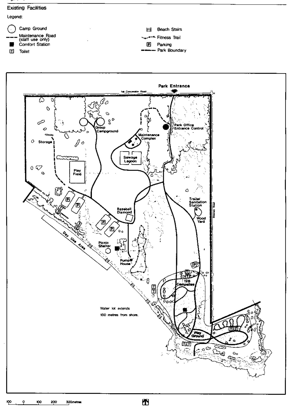
Day-use recreational opportunities are based on: an excellent beach, Lake Erie, landscaped picnic grounds, wooded areas, and a limestone rock point jutting into the lake. The park presently has 128 campsites, with approved plans to increase this to approximately 170 sites. Since the park is currently going through the last phases of development, which began in the mid to late 1970's, day use and camping facilities are modern and in good condition. From 1980 to 1983, day-use attendance increased by 15% to approximately 13,000 visitors annually. During this same period, camper nights increased 11%.
It is for the purpose of planning, development and management of the park’s natural and cultural resources and facilities, that this management plan is being prepared.
2. Summary of significant issues and policy decisions
A controlled and limited waterfowl hunt will be allowed on a trial basis. The opening day for hunting will be after Thanksgiving. As well, the hunt will be scheduled so as to minimize the conflict between bird watchers and hunters. A Wildlife Management Plan, addressing this topic will be prepared. (see Section 4.3)
A boardwalk, observation platform and stair system from the top of the bluff to the beach will be constructed to direct pedestrian movement and minimize impact on the dunes. As well, site planning techniques will be implemented to impede motorized use occurring on the dunes.
3. Park policies
3.1 Park classification
Rock Point is classified as a "Recreation" park in recognition of its wide variety of outdoor opportunities for recreation and its limited contribution to earth science and life science protection targets for this area by the Ministry of Natural Resources.
3.2 Park goal
To maintain and operate Rock Point so as to provide a wide variety of intensive and extensive outdoor recreational opportunities.
Figure 1: Regional Context
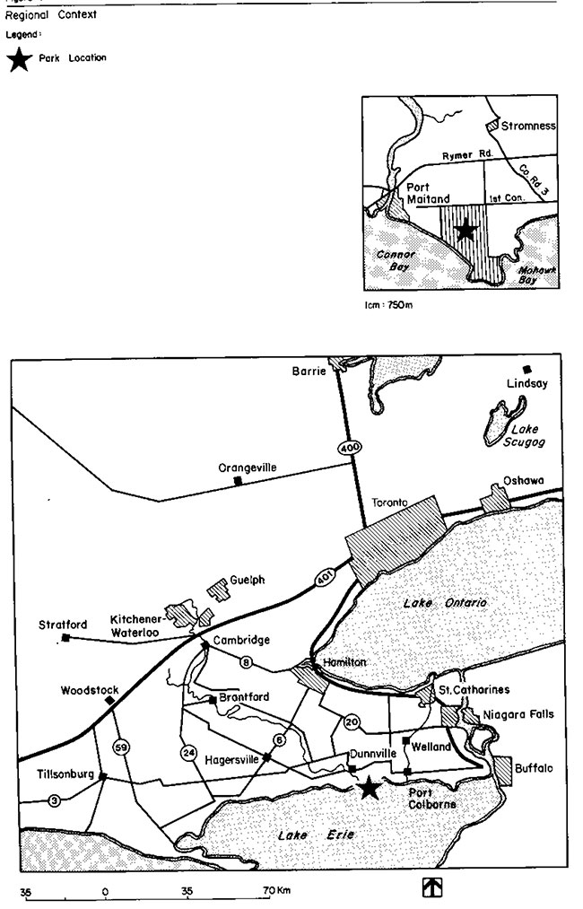
Enlarge Figure 1: Regional Context
Figure 2: Existing Facilities

Enlarge Figure 2: Existing Facilities
3.3 Park objectives
3.3.1 Recreation objective
The recreation objective of the Ontario Provincial Parks system is to provide outdoor recreation opportunities ranging from high-intensity day use to low-intensity wilderness experiences. The recreation objective for this park is to provide day use and camping recreation opportunities and facilities that utilize the area’s prime recreational resources.
- the parks proposed 170 campsites are estimated to represent 74% of the provincial park camping opportunities in the Ministry’s Niagara district to the year 2000 (the parks present 128 campsites offer 100% of these opportunities)
- the parks 1200 m of beach are estimated to represent 53% of the swimming opportunities in the Niagara district to the year 2000 (the park presently offers 100% of these opportunities)
- the parks 472 picnic tables are estimated to represent 39% of the picnicking opportunities in the Niagara district to the year 2000. (the park presently offers 100% of these opportunities)
(N.E.) The difference in camping, swimming and picnicking percentile opportunities between present day and the year 2000, represents an estimated increase in the number of similar opportunities to be made available elsewhere by the ministry, and does not reflect any proposed decrease in facility based opportunities at Rock Point.
3.3.2 Heritage appreciation objective
The heritage appreciation objective of the Ontario Provincial Parks system is to provide opportunities for exploration and appreciation of the outdoor natural and cultural heritage of Ontario. The heritage appreciation objective for this park is to provide a range of opportunities for the exploration, interpretation and appreciation of the various landscape units and natural features of the park. Interpretive facilities and programs will vary according to the significance of the resource, its accessibility and its required level of protection. Proposed facilities will include a trail, with interpretive signage, and an observation platform and stair system on top of the dunes at the point.
3.3.3 Tourism objective
The tourism objective of the Ontario Provincial Parks system is to provide Ontario’s residents and out-of-province visitors with opportunities to discover and experience the distinctive regions of the Province. The tourism objective for this park is to provide Ontario’s residents and out-of-province visitors, especially Americans travelling along the north shore of Lake Erie, with travel information and camping/day use opportunities in order that they can discover and experience the Niagara Peninsula. As well, the park contributed, in 1979, more than three-quarters of a million dollars to the provincial economy annually through park expenditures and tourist spending. it is the objective of the Ministry to maintain and possibly increase the economic contribution of this park to the local economy.
3.3.4 Protection objective
The protection objective of the Ontario Provincial Parks system is to protect provincially significant elements of the natural and cultural landscape of Ontario. The protection objective for this park is to protect earth science (sand dunes, the Lake Erie Shoreline, beach and shoreline bluffs) and life science resources (migrating birds, Carolinian plant communities). This will be achieved through zoning that is sensitive to the particular resource management needs of the park’s features as well as to the recreational pressures placed on these resources.
3.4 Park boundary
There are no plans for any major expansion of the park’s boundary. However, if funding and priorities permit, the purchase of two small adjacent beach front lots (total .5 ha) to the west would provide the park with additional prime beach (see Figure 2). This acquisition should be considered if these properties become available for sale.
3.5 Zones and zone policies
All lands within the park will be zoned (see Figure 3) in recognition of their existing and potential environmental qualities, required protection and their potential for recreation and interpretive use within the context of the overall four objectives (see 3.3 Park objectives)
Summary of zoning (land base only)
| Zones | Hectares |
|---|---|
| Development | 94 |
| Natural Environment | 67 |
3.5.1 Development zone
- The development zone contains the facilities and services for day-use picnicking, swimming, field sports, trails and camping. The existing maintenance complex and proposed of fice/entrance control structure are also located within this zone
- Area A, (see Figure 3) represents the location of future campground expansion to replace campsites which will eventually be phased out of Area B
- Management practices for Area A will include no mowing, and rehabilitation to as natural of a state as possible. Native tree and shrub species may be planted as well as soil scarification to enhance the regeneration process. In planting and encouraging regeneration, consideration will be given to future locations of campground roads. Future expansion of camping to this regenerated area will provide a more natural setting for camping
Area B contains a campground that will eventually be phased out, allowing this area to become more naturalized. A Vegetation Management Plan for regeneration and planting of native and wildlife attracting plant species, will be produced and implemented initially working around the campsites.
At some point in the future, Area B may be rezoned to natural environment.
Development zone policies
- To improve the landscape aesthetics and the environmental quality of this zone, where possible
- To maximize recreational opportunities by maintaining and improving upon existing resources/facilities and the provision of new facilities as deemed necessary
3.5.2 Natural environment zone
The landscapes zoned as natural environment include woodlots, old pastures, sand dunes and limestone rock pavement at the point.
Natural environment zone policies
To protect the natural features found in these areas from detrimental forms of development and recreational use. Earth science features worthy of protection include the sand dunes, the shorebluff and the limestone rock pavement. Life science features include the large numbers of migratory birds that are attracted to the point. As well, the woodlots and the old pastures contain a rich diversity of Carolinian plant species.
- To allow appropriate forms of recreational activities to occur (e.g., hiking, nature appreciation)
- To monitor these appropriate recreational activities to ensure no future detrimental effect develops affecting the zone’s resources
- To take approved management initiatives to improve and enhance the environmental qualities and resources in these areas
Figure 3: Zoning
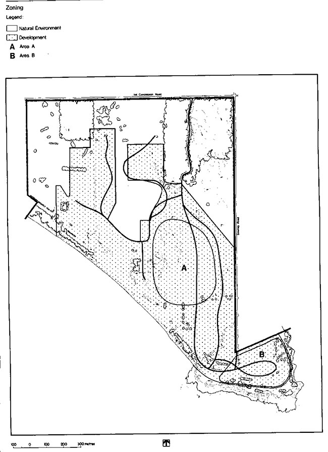
4. Resource management
4.1 Land and water management
- As long as feasible, the park will continue to operate and extract natural gas from wells located within the park, for park purposes (i.e., water and space heating)
- Attempts will be undertaken to stabilize the sand dunes, a noteworthy and fragile earth science feature of this park
- The Lake Erie beach and shorebluff erosion is a natural dynamic process. Costly engineered means of stabilizing the beach and shorebluff will not be undertaken. Instead, the effects of erosion will be minimized by:
- establishing plant species along the shorebluff that are adapted to stabilizing slopes
- site planning set-backs of all facilities from the bluff edge, and
- controlling pedestrian circulation on the bluffs, by strategically locating beach stairs and vegetative barriers
- Attempts to resolve drainage problems, by surface means, will occur in the development zones
- No commercial mineral, fossil fuel, sand and aggregate exploration and extraction will be permitted within the park
- Archaeological excavation for only authorized research purposes will be allowed
- Removal of fossils for approved scientific research proposals will be allowed
4.2 Vegetation Management
The Ministry of the Environment is monitoring the situation and the Ministry of Natural Resources will take appropriate action if and when required.
Planting and maintenance program
Woodlot management program
- Future research, into the effect of the adjacent industrial floride emissions on the park’s plant material, may suggest the planting of species, native or not, that are less susceptible to the effect of floride poisoning
- Non-threatening native forest and vegetative insects and diseases normally will be allowed to develop undisturbed. Control measures, if necessary, will be undertaken if the aesthetic values within or outside the park are threatened. Where control is desirable and feasible, it will be directed as narrowly as possible to the specific insect or disease so as to have minimal effects on other components of the park’s environment
- Management of existing vegetation and proposed planting projects including a mowing program will be addressed in a Vegetation Management Plan. This plan will include the following:
- will identify areas to be mowed and areas presently mowed that will be planted or allowed to regenerate
- to ensure a variety of natural regenerative areas, some areas will be allowed to evolve on their own, while other regeneration areas will be supplemented with plantings
- regeneration may be speeded up with soil scarification
- recommendations for colonizing plant species suitable for stabilizing sand dunes and shorebluffs
- existing plantings will be assessed for their appropriateness
- existing woodlots will be allowed to evolve with minimum management (i.e., management to control disease outbreaks, insects, etc. that threaten other values of the park)
- where trees are removed for management or development purposes, they may be marketed if economic
4.3 Fauna Management
- Commercial fishing and commercial bait fishing will not be allowed within park waters
- Sport fishing will be encouraged in park waters
- Animal control, if necessary, may be carried out under the strict supervision of or directly by the Ministry of Natural Resources
- A controlled and limited waterfowl hunt will be allowed, initially on a trial basis. A proposed Wildlife Management Plan will address the hunt. It is recommended that the hunt be confined to four blinds, all of which will be temporary and portable in nature. The hunt will be self-serve and operate from the third Saturday in October, until the close of the waterfowl season. The actual days to be scheduled for hunting will be determined by the Wildlife Management Plan
- Wildlife habitat improvements will be addressed in the Vegetation Management Plan
5.1 Client services management
5.1 Visitor services
As a small provincial park with regionally-significant earth and life science features, a low-keyed basic level of visitor services is provided. The goal of visitor services is to provide visitors with a system of basic park information and a variety of family-oriented recreational facilities and programs. Of the four visitor service components (communication, recreation, interpretation and outdoor education), the former three are emphasized at this park.
5.1.1 Communication
Objectives of this component should include the following:
- inform park visitors about the park, its services, facilities and management concerns
- inform visitors about recreational and interpretive opportunities in the local area
- inform visitors of the role of the Ministry of Natural Resources
- instill a sense of respect in visitors for the park environment
- provide a means of feedback for visitors to communicate to the Ministry of Natural Resources
The above objectives will be achieved through all or some of the following: publications, signage, audio-visual presentations, displays, mass media and personal contact.
5.1.2 Recreation
The park has a high potential for self-use recreation with a waterfront for sunbathing and swimming. As well, self-use recreation can occur on a play field, fitness trail and a proposed nature trail.
To supplement the park’s recreational facilities, a free recreational equipment loan program may be offered.
Limited staff-led recreational activities will be provided as funds and staff priorities permit. They may include campfire, craft and Water-oriented programs. Such programs will lead to an involvement with the natural and cultural features of the park.
5.1.3 Interpretation
The level of interpretation of the park’s resources will not be intensive since the story of the park’s resources and man’s relationship to it, is not considered that significant.
Trails, a trail guide and displays are the self-use facilities, offering opportunities for interpreting the following resource components:
Earth Science
Life science
Cultural
- One of the most significant geological features to be interpreted, involves the Rock Point and Devonian fossils and glacial striations found on the limestone flats. The process of fossilization and the paleoclimatic conditions that produced such fossils, will be emphasized. Other earth science features worthy of interpretation include the dunes, the Lake Erie shoreline, beach, and shoreline bluffs
- The migrating birds attracted to the park’s land base and the Carolinian plant communities characteristic of the area, have interpretive potential
- The artifacts found on site, and the Archaic peoples' culture are worthy of interpretation. Of minimum significance are the early uses by man of the park’s Umber and natural gas resources
5.2 Recreation management
- Park activities and facilities will be directed by guidelines and procedures, in accordance with the Rock Point Provincial Park Management/Operating Plan
- Park patrons will be encouraged to not only utilize recreational opportunities within park boundaries, but also to utilize opportunities and facilities outside the park
- Park management will monitor the security problem resulting from the close proximity of a cottage community to the park’s campground • Recommended solutions may include improved site design and tighter security enforcement
- During the off-season when the park is closed and locked, walk-in use is encouraged. Winter parking will be provided at the entrance to the park. Park management will solicit municipal snowplows to keep this parking lot open
- Though year-round camping will not be offered, some electrified campsites may be available during the shoulder season, if demand warrants
- Snowmobiles will not be allowed in the park until a greater visual distinction exists between the roads and the adjacent natural regeneration areas
5.3 Commercial services
At present, a firewood concession operates at the park.
Depending on a demonstrated need, a concession offering basic-camping and day-use supplies will be provided.
Additional concessions may be added or existing ones modified according to the district parks and recreation section as well as in keeping with park goals and objectives.
5.4 Marketing
The following is a priority ranking of provincial park marketing strategies that apply to Rock Point:
- Hold present customers longer
- Repatriate customers lost during the rowdyism of the 70's
- Attract day users who will stay in local service accommodations and use local services
- Increase day use where high volume (i.e., groups) can be achieved
Marketing and operational initiatives, as - outlined in an updated "Marketing Manual for Rock Point Provincial Park", will be implemented in order to obtain the above results.
6. Development
The following is a list of development items that are proposed for the park (see Figure 4). Approved site plans are required for all development.
6.1 Camping
The campground has recently undergone the first phase of redevelopment to increase the number of campsites from the original 47 to the present 128. An approved campground redevelopment plan (1977), to be phased in, calls for the eventual total number of sites to increase to approximately 170. The 170 campsites represent an actual addition of 92 new sites since approximately 50 existing sites will be removed from the point (see Area B, Figure 3). These campsites on the point are to be phased out for environmental reasons in an area that may be rezoned natural environment in the future (see Section 3.5.1). Phasing out of these sites depends on the replacement availability of new sites.
A new comfort station is proposed in conjunction with the eventual provision of 170 campsites.
6.2 Day use
Park management will encourage local agencies to establish a boat-launching facility, outside of the park, but in the immediate area (preferably in the Grand River). Only smaller and car-top type of boats, not requiring a boat launch, can be launched from the park.
6.3 Trails
A self-guided nature trail will be established in the park. Facilities will be kept to a minimum except in the dunes area. Here a boardwalk, observation platform and a stair system will be provided to direct pedestrian movement across the dune and down the beach, thus minimizing environmental impact.
Locations for trails will be selected on the basis of landscape capability, resource sensitivity, and appeal to the users. Specific trail locations will be identified in a Trail Development and Maintenance Plan. This plan will ensure a suitable trail system is created; one that is easily accessible from the development zone to campers and day-users alike and includes the various landscape units of the park (e.g., woodlots, shrubland, regeneration areas, dunes, limestone beach, shorebluff and sand beach).
6.4 Administration and service facilities
A new park building, combining the functions of the park office and entrance control, will be built, pending funds and priorities, further inside the park, at the junction of the day-use and campground roads. The existing park office is spatially inadequate to satisfy the administrative needs of the park. This office is also not ideally located for efficient security and control.
The existing park office/entrance control structure will be removed, and the site will be rehabilitated to return to a natural state. The same will be done for the abandoned road from the existing park office to the maintenance complex.
7. Implementation strategy
The following is a priority listing in decreasing order or importance of development projects planned for the park. All development items will be implemented as funds and priorities permit.
- construction of boardwalk, observation deck and beach stairs at the dunes
- trail development (includes signage)
- assisting local agencies with the provision of nearby boat-launching facility
- construction of 90-site campground (includes roads and comfort station)
- construction of new park office/entrance control structure
- phasing out campground at point
- removing old office and rehabilitate site
- removing abandoned maintenance road through woodlot and rehabilitate
Figure 4: Proposed Development
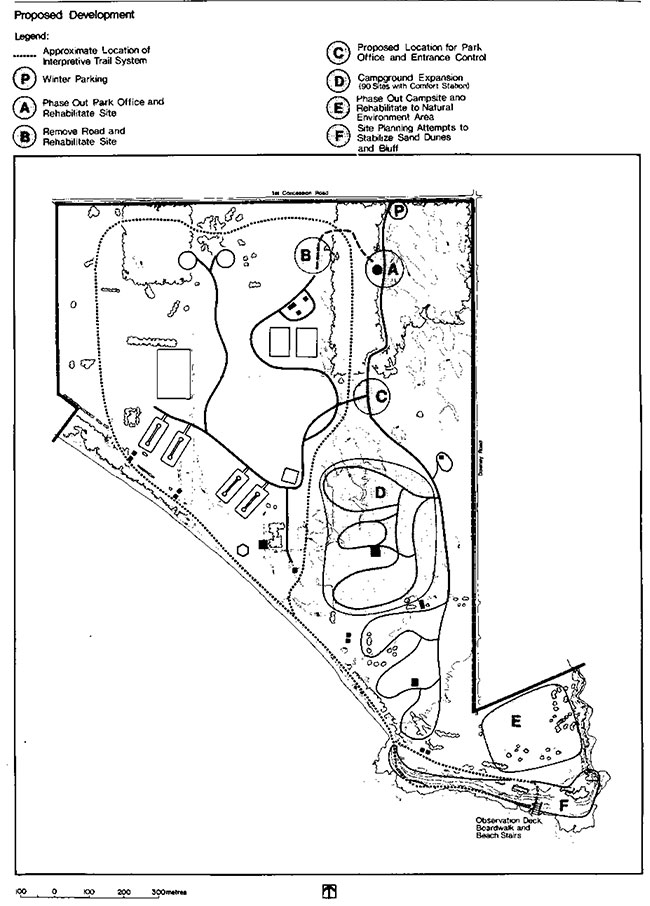
Enlarge Figure 4: Proposed Development
This management plan will be reviewed when major issues surface and at least once within the next ten years. Any necessary plan amendments will be made with public involvement in accordance with apparent needs. As funds and priorities permit, additional research will be conducted on natural and cultural values, recreational user demands and behaviours, so as to improve the plan. The preparation of a Wildlife Management Plan will be given top priority especially since there is increasing pressure for waterfowl hunting at the park. The Vegetation Management Plan and Trail Development and Maintenance Plan will also be initiated as soon as possible.
8. Summary of public consultation
Public consultation during the management planning process for Rock Point focused on the local area and included the following:
- a news release and advertisement in the Dunnville Chronicle. A news release only was sent to the Hamilton Spectator
- copies of this draft plan forwarded to local levels of government for review (Regional Municipality of Haldimand-Norfolk, Town of Dunnville, Grand River Conservation Authority)
- copies of this draft -plan sent to the Federation of Ontario Naturalists and the Ontario Federation of Anglers and Hunters
- copies of the news release sent to interest groups such as Long Point Bird Observatory, Canadian Wildlife Service, Niagara Falls Nature Club, Port Colbourne and District Nature Conservation Club, St. Catherines Game and Fish Association
- where appropriate, contact will be made with adjacent landowners, by park management, to inform these landowners of the draft plan and its contents
- announcements and posters were on display in the park during the summer of 1984 advising park visitors of availability of plan for review at the park office
All comments and suggestions received from the public were considered while finalizing this plan. For additional information on methods used and results of various forms of preliminary efforts with public consultation, please see Appendix in Rock Point Provincial Park Management Plan - Background Information Document.
9. References
Chanasyk, Victor; The Haldimand -Norfolk Environment Appraisal -Volume 1 and 2, 1970, Ontario Ministry of Treasury, Economics and Intergovernmental Affairs.
Haldimand-Norfolk Joint Study Committee; A Lakeshore Study of the Haldimand and Norfolk Counties, 1974.
Helling, Lichenfeld, Harvey, Schreiber; Rock Point Provincial Park- Ecological Survey, 1971.
Lindsay, K. M.; Rock Point Provincial Park Environmental Planning Series, Life Science Report, Volume 5, Number 9, 1974, Park Planning Branch, Ontario Ministry of Natural Resources.
Macdonald, I. D.; Life Science Features of the Haldimand Clay Plain Physiographic Region,1980, Ontario Ministry of Natural Resources.
Mahon, D.; Rock Point Architectural Report, 1972, Ontario Ministry of Natural Resources.
Ontario Ministry of Natural Resources, Outdoor Recreation Group, 1979 Provincial Park Camper Survey - Summary Statistical Report, 1980.
Regional Municipality of Haldimand-Norfolk; Interim Planning Guidelines, 1975.
Ontario Ministry of Natural Resources, Outdoor Recreation Group; 1979 Provincial Park Visitor Survey - Summary Statistical Report, 1980.
Ontario Ministry of Natural Resources, Outdoor Recreation Group; 1979 Provincial Park, Preliminary Master Plan,1976.
Ontario Ministry of Natural Resources, Rock Point Provincial Park Management Plan - Background Information Document, 1984
Ontario Ministry of Natural Resources, Niagara District Land Use Guidelines, 1983.
Ontario Ministry of Natural Resources, Rock Point Provincial Park, Data for Master Planning, 1972.
Ontario Ministry of Natural Resources, Outdoor Recreation Group; Visitor Services Plan,Central Region, 1978.
Regional Municipality of Haldimand-Norfolk; Policies for the Regulation of Lakeshore Development - A technical report, 1976.
Warren, W. D.; Rock Point Provincial Park, Environmental Planning Series Earth Science Report, 1974.