Ruby Lake Park Management Plan (2009 – Amended 2019)
This document provides policy direction for the protection, development and management of Ruby Lake Provincial Park and its resources.
Amendment approval statement
August 28, 2019
Dear Sir or Madam:
I am pleased to approve this amendment to the management statement for Ruby Lake Provincial Park. The amendment provides revised direction in the management statement for the issuance of commercial tenure and conditions of any disposition, including requirements under the Provincial Parks and Conservation Reserves Act, 2006 and approval through an environmental assessment process.
I would like to express my appreciation to those who participated in the planning process.
Sincerely,
Jason Travers, Director
Ontario Parks
Approval statement
April 28, 2009
I am pleased to approve the Ruby Lake Provincial Park Management Plan as the official policy for the management and development of this park. The plan reflects the intent of the Ministry of Natural Resources and Ontario Parks' intent to protect the natural and cultural features of Ruby Lake Provincial Park and to maintain and develop opportunities for high quality outdoor recreation experiences and heritage appreciation for the residents of Ontario and visitors to the Province.
This document outlines an implementation strategy for the plan’s elements and summarizes the public consultation that occurred as part of the planning process. Consultation occurred at the Terms of Reference, Background Information/Issues and Options, Preliminary Park Management Plan and Scoped Zoning Options for the Preliminary Park Management Plan. Consultation included direct notices, newspaper advertisements, interest group meetings, the Ontario Parks website and postings on the Environmental Bill of Rights registry.
The plan for Ruby Lake Provincial Park will be used to guide the management of the park over the next twenty years. During that time, the management plan may be reviewed to address changing issues or conditions, and may be amended as the need arises. This plan will be examined in accordance with the provisions of the Provincial Parks and Conservation Reserves Act in 10 years.
I wish to extend my sincere thanks to all those who participated in the planning process.
Yours truly,
Signed by:
Donna Cansfield
Minister of Natural Resources
Statement of Environmental Values and the Environmental Bill of Rights
The Ministry of Natural Resources' Statement of Environmental Values (SEV) under the Environmental Bill of Rights (EBR) describes how the purposes of the EBR are to be considered whenever decisions are made in the Ministry that might significantly affect the environment. This includes decisions made as a result of preparing management direction for a protected area.
The Ministry’s SEV has been considered throughout the planning process. The management direction for Ruby Lake Provincial Park will further the objectives of managing Ontario’s resources on an environmentally sustainable basis.
Provincial Parks and Conservation Reserves Act
The Provincial Parks and Conservation Reserves Act (PPCRA) is the legislation that guides the planning and management of the protected areas system. The PPCRA has two specific principles that guide all aspects of planning and management of Ontario’s system of provincial parks and conservation reserves:
- Maintenance of ecological integrity shall be the first priority and the restoration of ecological integrity shall be considered
- Opportunities for consultation shall be provided. 2006, c. 12, s. 3
Planning context
This park management plan has been prepared consistent with direction contained in Our Sustainable Future, Ministry of Natural Resources Strategic Directions (2005). The Ministry’s vision is "sustainable development"; and the Ministry’s mission is "ecological sustainability". The Ontario Parks program contributes mainly to the goal of: "Healthy Natural Environment for Ontarians", but contributes to other strategic elements as well. The mandate of the Ministry for Ontario Parks is to deliver Ontario’s parks and protected areas program, which includes: the protection and management of provincially significant natural, cultural, and recreational environments; provincial parks operations; provision of tourism opportunities, natural heritage education; planning and management of parks and protected areas; policy leadership on conservation reserves; monitoring, auditing, and public reporting on Ontario’s parks and protected areas.
This document has also been prepared consistent with direction contained in Protecting What Sustains Us: Ontario’s Biodiversity Strategy (2005). Ontario Parks supports both the first goal "Protect the genetic, species and ecosystem diversity of Ontario", and the second goal: "Use and develop the biological assets of Ontario sustainably, and capture benefits from such use for Ontarians". In particular Ruby Lake Provincial Park will be managed to protect any species at risk and their habitats.
The Interim Management Statement for Ruby Lake Provincial Park was approved in 2000. It described the park’s contribution to the provincial park system, and identified existing policies intended to maintain this contribution. This document provided some of the background information for the present planning process. The park management plan
This park management plan sets direction for the next 20 years by establishing policy and identifying appropriate development consistent with Ontario Parks goals and objectives of natural environment class provincial parks.
Aboriginal context
Ruby Lake Provincial Park is within the boundaries of lands covered under the Robinson-Superior 1850 Treaty, and is within the traditional use area of the Red Rock First Nation. In recognition of the park’s location within this traditional use area, Ontario Parks will have regard for the First Nations' particular interests. The Red Rock First Nation will be consulted on related issues of concern during the implementation of this plan. Members of this Aboriginal community use the area for hunting, trapping, fishing, and other gathering. These uses may continue, subject to public safety and conservation.
The Red Rock First Nation consists of two sections, Parmacheene Reserve 53 and Lake Helen Reserve 53A, which are located at 8 km, and 2.5 km (straight-line distance) from the park respectively.
1.0 Introduction
Ruby Lake Provincial Park was identified in 1999 as part of Ontario’s Living Legacy (OLL) and is part of the OLL Great Lakes Heritage Coast Signature Site. The park was regulated in May 2002 (O. Reg. 147/02). The classification is natural environment. Ruby Lake is also located adjacent to Parks Canada’s National Marine Conservation Area. The park covers a total of 2,734 hectares and is situated on the north shore of Lake Superior, at the mouth of the Nipigon River near the towns of Nipigon and Red Rock, and the Red Rock First Nation. The park does not include any waters of Lake Superior. (Figure 1).
Nipigon and Red Rock are both approximately 2.5 km (straight-line distance) from the western boundary of the park.
Ruby Lake Provincial Park incorporates three small lakes, wetlands and a mesa-cuesta named Doghead Mountain with cliffs and ravines that provide important habitat for bald eagle, and peregrine falcon, both of which are species of risk in Ontario
2.0 Park classification
Through park classification, Ontario’s provincial parks are organized into broad categories, each of which has particular purposes and characteristics.
All provincial parks in Ontario fall into one of six classes: wilderness, nature reserve, cultural heritage, natural environment, waterway and recreation. Natural environment parks incorporate outstanding recreational landscapes with representative natural features and cultural resources. These parks provide high quality recreational and educational experiences.
Ruby Lake Provincial Park is classified as a natural environment park. Ruby Lake Provincial Park fulfills the representation target for natural environment class parks in Ecodistrict 3W-3. The natural environment classification reflects the park’s provincially and regionally significant natural features, as well as its regional historical legacy and recreational values.
3.0 Park management goal
To protect the outstanding landscape and provincially and regionally significant natural and cultural features of Ruby Lake Provincial Park and to provide opportunities for compatible heritage appreciation, outdoor recreation, and scientific research within the scenic landscape of the north shore of Lake Superior.
4.0 Objectives
Ontario’s provincial parks system has four objectives for establishing and managing provincial parks, as stated in Ontario’s Provincial Parks and Conservation Reserves Act, to:
- permanently protect representative ecosystems, biodiversity and provincially significant elements of Ontario’s natural and cultural heritage and to manage these areas to ensure that ecological integrity is maintained
- provide opportunities for ecologically sustainable outdoor recreation opportunities and encourage associated economic benefits
- provide opportunities for residents of Ontario and visitors to increase their knowledge and appreciation of Ontario’s natural and cultural heritage; and
- facilitate scientific research and to provide points of reference to support monitoring of ecological change on the broader landscape
Each park in the system contributes in some way to one or more of these objectives, depending on its resource base. Ruby Lake Provincial Park contributes to the achievement of all four objectives.
4.1 Protection objective
To permanently protect the provincially and regionally significant natural and cultural features of the park including, geological and geomorphological features, raptor habitat, arctic - alpine disjuncts and other rare plants and to manage these to maintain ecological integrity.
Ruby Lake Provincial Park contains a variety of natural and cultural resources that are provincially and regionally significant. These include:
- The Keweenawan diabase sills, whose tabular form has resulted in the distinct mesa-cuesta landforms that characterize the physiography of this corner of the province (provincially significant)
- A complete spectrum of lake levels to have affected the area following the retreat of the Marquette Advance (provincially significant)
- Basic Open Cliff and Basic Open Talus vegetation types (provincially significant)
- Crevasses, talus, and cliffs bathed in cold air, as well as the cool shoreline of Lake Superior that provide habitat for alpine-arctic disjuncts (regionally significant)
- Areas of lime rich soils provide habitat for orchids and other rare plants
- Several satellite camps of Kallio’s logging camp
The protection objective will be accomplished through appropriate park zoning, resource management policies, research, monitoring, adaptive management and an ecosystem approach to park planning and management.
4.1.1 Earth science
Ruby Lake Provincial Park lies within the Canadian Shield, in a vast area of ancient rock of Precambrian origin. The Shield forms the foundation of the North American continent and consists of some of the oldest rock on earth. It is divided into geological provinces and sub-provinces based on differences in rock type, structure and age. The park lies within the Southern Structural Province in an area formerly known as the Nipigon Plate (Stockwell et al, 1972) but now referred to as the Nipigon Embayment (Sutcliffe, 1991). The Nipigon Embayment consists of a sequence of Mesoproterozoic, pre-Keweenawan sedimentary rocks of the Sibley Group (quartz arenite, argillaceous dolomite and mudstones) that formed about 1.3 billion years ago, and the Keweenawan Nipigon diabase sills that were intruded into the Sibley sequence about 1.1 billion years ago. These rocks, which overlie the older Achaean Superior Province basement complex, extend north from Lake Superior to subtend an area roughly coincident with the Lake Nipigon basin.
The Keweenawan diabase intrusive sills dominate the landscape in this area. Diabase, a very dark, basic, igneous rock was intruded as magma parallel to the bedding planes of the Sibley sediments. Differential erosion (the diabase is more resistant to erosion than the sediments) has resulted in tabular or sheet-like forms (sills) that cap the softer sediments and now dipping cuestas. Structures within the diabase determine the spatial form of these features. Prominent joint sets (fractures) develop perpendicular to the plane of injection due to contraction within the cooling magma. Erosional processes (e.g., freeze-thaw) work on these zones of weakness (i.e., the columnar jointing) which results in the vertical cliffs (escarpments) that characterize the mesas and cuestas. The eroded materials collect as boulder-sized colluvial talus at the base of the cliffs (Noble 2000).
A high, isolated diabase sill dominates Ruby Lake Provincial Park. Although similar features in the area take on an almost flat-topped mesa configuration, the Ruby Lake landform can be placed in the "cuesta" category given its south-dipping backslope. Cuestas are described as a "ridge with a gentle slope on one side, and a precipitous escarpment on the other" (Pye, 1969). The cuesta is divided into two parts by a wide erosional lineament now occupied by Ruby Lake. The cuesta consists of a vertical escarpment on its north and west sides. The latter cliff face, which is just beyond the west boundary of the park, serves as the east bank of the Nipigon River. Abutting the cliff is an apron of steeply sloping boulder talus. The highest point along the escarpment rim is Doghead Mountain (374 metres above sea level (asl)). In comparison with other cuesta backslopes, this one has an unusually steep gradient. The backslope consists, for the most part, of wave-washed bedrock, particularly in the section west of Ruby Lake.
The last ice advance to override Ruby Lake Provincial Park was the Marquette Advance, which occurred roughly 10,000 years ago. The park was uncovered after the ice retreated across the lake to beyond the north shore. Glacial Lake Minong followed the ice back and ultimately filled the Lake Superior basin (Farrand 1960; Farrand and Drexler 1985). Following retreat of the ice from the north shore there was a succession of lowering lake levels in the Superior basin, including several significant fluctuations as glacial Lake Agassiz drained eastward, one rising level (i.e., the Nipissing Transgression), and then continued lowering levels down to the present Lake Superior (Noble 2000).
The highest points in the park were first exposed in the Pre-Minong glacial lake levels (before the Marquette ice had completely evacuated the basin), as is evidenced by a sporadic veneer of water-worked till and sand and gravel beach materials, particularly on the backslope east of Ruby Lake. From the Nipissing bluff down to the Algoma shore the amount of unconsolidated materials increases to where it is almost the shore the unconsolidated material is deeper and consists of lacustrine clays and low strands of beach sand and gravels. This sloping apron of lacustrine materials, which reflects bedrock control, extends as a band along the south shore backing the cuesta. Near Ruby Creek, however, it swings in front of the cuesta escarpment where it forms a low gradient lacustrine lakebed that was protected from storm impact by the cuesta itself. This relatively flat plain is drained by the somewhat meandering and slightly incised Ruby Creek. The low gradient, high water table and clay substrate in this area have been conducive to a build-up of peat, which, in places, is as much as a metre deep. The combination of peat over clay continues to the northern boundary of the park and stretches around the edge of Fire Hill Bay to the eastern extremity of the park at the mouth of the Jackfish River.
The provincially significant earth science features (as listed in Section 4.1) of Ruby Lake Provincial Park are of interpretive and educational value. Earth science features are protected within nature reserve and natural environment zones.
4.1.2 Life science
Ruby Lake Provincial Park is situated in Ecodistrict 3W-3 (Black Sturgeon). Ruby Lake is also located within the Superior section of Rowe (1972) and the Black Sturgeon Site District of Hills (1959). Forest soils are largely dictated by the impacts of glaciation, wave action of glacial lakes, and water drainage from the landscape.
Exposed bedrock occurs in upland areas along cliff edges where climatic conditions are not conducive to tree growth. Tree growth in these areas is stunted with eastern white cedar, white birch, white spruce, black spruce and trembling aspen present in low abundance.
The diabase cliffs and talus slopes of the Doghead Mountain cuesta form a rare type of open habitat in a forested area, with sparse vegetation dominated by shrubs, mosses and lichens. The diabase cliffs also provide a relatively nutrient rich substrate. These conditions combine to form rare to uncommon vegetation types in Ontario: Basic Open Cliff Type and Basic Open Talus Type (Bakowsky 2002). Ice filled crevasses occur among the exposed bedrock at the base of some cliffs. Plants of arctic/alpine affinity have a normal range that includes alpine habitat in British Columbia, the Yukon Territory, and the state of Alaska (Pratt 1991), or arctic habitat like that found 63º north to Hudson Bay and James Bay (Johnson 1987). Occurrence of these species in the area is significant range. Ruby Lake Provincial Park is one of a number of significant sites for arctic/alpine disjunct plants on the north shore of Lake Superior.
Upland conifer forests occur on the top of Doghead Mountain in the western section of the park. Dominant tree species include jack pine (Pinus banksiana) and black spruce (Picea mariana). West of Ruby Lake, these stands are the result of a natural fire, but in the area southeast of Ruby Lake, trees have been planted in recently harvested areas.
Upland deciduous forest covers a large portion of Doghead Mountain, surrounds most of McLennan Lake, and occupies several other patches, primarily in the western section of the park. Trembling aspen (Populus tremuloides) is the dominant tree species, however, white birch (Betula papyrifera) also occurs. Balsam fir (Abies balsamea) is consistently present in the regeneration layer along with white birch, black spruce, and white spruce (Picea glauca).
Birch dominated forest occurs on slopes and other areas of moderate elevation within the park. This forest type surrounds Kallio’s Pond, the southern slopes of Ruby Creek, and other patches in the western portion of the park. The dominant tree species is white birch, however, balsam fir and trembling aspen also occur. Eastern white cedar (Thuja occidentalis) occurs where water tables are high, or next to intermittent streams.
Black Spruce Lowlands occur on the glaciolacustrine flats in the eastern section and on low-lying areas in the southwestern portion of the park. Black spruce is the dominant canopy tree species with white birch, balsam fir, and eastern white cedar occurring occasionally in the canopy and regeneration layer.
Cedar forest with some white birch, white spruce, and willow (Salix spp.) occurs west of the forest reserve, and in the lowlands starting east of Fire Hill Creek and running toward the Jackfish River along the Lake Superior coastline.
Brush and alder (Alnus spp.) wetlands occur around the beaver pond in the southwestern portion of the park, adjacent to the Ruby Creek junction, in patches along the railway, and along the Lake Superior shoreline in the eastern part of the park. Treed muskeg occurs just west of the beaver meadow area, north of the long grass-strip in the middle section of the park. Open wetland meadows occur in and around sections along the edges of Ruby Lake, Ivan Lake, Kallio’s Pond, along the most western portion of Ruby Creek, and at the old beaver pond meadows.
The inland lakes of Ruby Lake Provincial Park are Ruby Lake, Ivan Lake, McLennan Lake, and Kallio’s Pond. Ivan Lake is the result of a permanent beaver dam at the south end of the waterbody, where it runs into Ruby Lake by way of a short stream. There is an extensive cattail and sedge/grass wetland along the shores of Ivan Lake with a narrow stretch of open water down the centre and numerous small ponds around the edges. The area is rich in wildlife, with songbirds and waterfowl, including nesting loons. Both Ruby Lake and McLennan Lake are identified as moose aquatic feeding areas. Kallio’s Pond is a small water body situated in the northwestern section of the park.
The wildlife of Ruby Lake Provincial Park is representative of the Boreal Forest Region. Mammals include: moose (Alces alces), white-tailed deer (Odocoileus virginianus), black bear (Ursus americanus), timber wolf (Canis Lupus), lynx (Lynx canadensis), marten (Martes americana), red fox (Vulpes vulpes), snowshoe hare (Lepus americanus), river otter (Lutra canadensis), beaver (Castor canadensis), red squirrel (Tamiasciurus hudsonicus), least chipmunk (Tamias minimus), and northern flying squirrel (Glaucomys sabrinus).
More than sixty species of birds have been observed in Ruby Lake Provincial Park area (Bryan & Moore, Bryan 1998, Hutchinson 2001). A number of species nest in the area, including bald eagle, osprey (Pandion haliaetus) and red tailed hawk (Buteo jamaicensis). Peregrine falcons were released on the east shore of Ruby Lake in the early 1990s as part of a reintroduction effort to restore this endangered species; cliffs along the northeast shore were used as hacking sites. Falcons are not known to nest within the park boundaries, although these cliffs are considered suitable habitat. The provincially significant American white pelican (Pelecanus erythrorhynchos) has also been observed flying over the park and is known to forage in Ruby Lake (Ratcliff 2000). The American white pelican is also a regulated endangered species in Ontario and is protected under Ontario’s Endangered Species Act. Other avifauna include: ruffed grouse (Bonasa umbellus) and spruce grouse (Falcipennis canadensis), common raven (Corvus corax), blue jay (Cyanocitta cristata), gray jay (Perisoreus canadensis) and a wide variety of songbirds.
The eastern garter snake (Thamnophis sirtalis sirtalis) is the only reptile to be found in the park. Amphibians include the northern leopard frog (Rana pipiens), boreal chorus frog (Pseudacris maculate), spring peepers (Pseudacris crucifer) and the American toad (Bufo americanus). All can be heard calling in the spring and early summer.
Ruby Lake Provincial Park contains Ruby Lake, McLennan Lake and Ivan Lake. Sport fishing for pike and perch occurs on Ruby Lake. Since a stream connects Ivan Lake to Ruby Lake, it likely holds a similar species component as Ruby Lake. The sport fish species present in McLennan Lake have not yet been assessed. Ruby Creek contains brook trout (Salvelinus fontinalis), brook stickleback (Culaea inconstans), mottled sculpin (Cottus bairdi), and slimy sculpin (Cottus cognatus). Rainbow trout (Oncorhynchus mykiss) and pickerel (Stizostedion vitreum vitreum) have also been found in one of Ruby Creek’s tributaries (MNR 1998).
Provincially significant life science values (as listed in Section 4.1) are protected within nature reserve and natural environment zones.
4.1.3 Cultural features
As the glaciers retreated, Aboriginal people moved into the Ruby Lake area in small nomadic groups who gathered, hunted and fished, occupying different seasonal habitation sites. The archeological record to date for the Nipigon area indicates habitation that dates back 4000 years to the late Archaic period and the Shield culture with copper tools. Although no archeological sites have been identified within Ruby Lake Provincial Park, the pictographs located just outside of the park boundary (at the mouth of the Nipigon River/Cooks Point) attest to the presence of Aboriginal people in this area.
The French initiated fur trade in the region in 1656 when a commission which covered lands from the Gulf of St. Lawrence to lac des Alepinigons (Lake Nipigon) was granted to Sieur Zacharie Dupuy by the Governor of New France, Jean de Lauzon. Missionaries began entering this area in 1667 when Father Claude Jean Allouez arrived to minister to a band of Nipissing Indians. Trading forts and supply centres were established starting in 1679, including the Hudson Bay Company Red Rock House at the mouth of the Nipigon River in 1821. As the fur trade became established, the Ojibway people expanded their activities to include hunting and trapping for trade purposes. After British conquest, in the late 1700s, a large influx of traders entered the district. By 1871, when Canadian Pacific Railway surveyors arrived, there was a full-fledged town and harbour to be mapped.
Construction of the Canadian Pacific Railway adjacent to what is now Ruby Lake Provincial Park would have impacted the area through extraction of some aggregate, timber, water, food and dwelling related resources. Evidence of railway building activity is still present in the park both in the form of the railway itself, and a railway bank support wall immediately east of Ruby Lake.
A marble quarry operated between 1885 and 1910 close to the park’s western boundary.
Evidence of past logging exists in various parts of the park. The remains of a Kallio’s satellite logging camp, circa 1940 are located on the shores of McLennan Lake. A fire swept through the camp and renewed much of the area to a trembling aspen and white birch dominated primary successional stage of forest. Evidence of more recent logging activities includes the roads and cut patches still evident to the east and south of Ruby Lake that can be seen on aerial photographs of the area.
The park’s cultural features (as listed in Section 4.1) are protected within natural environment zones.
4.2 Heritage appreciation objective
To provide opportunities for residents of Ontario and visitors to increase their knowledge and appreciation of Ontario’s natural and cultural heritage.
There are three levels of Natural Heritage Education service in the provincial park’s system: Self-use, Seasonal Activity, and Major Activity. Ruby Lake offers a self-use level of programming. Self-use parks provide comprehensive information / orientation services as well as self-use facilities such as trails and playgrounds. Park staff maintain these facilities. Additional public programs may be offered at the discretion of the park superintendent.
The primary interpretive themes for Ruby Lake presently include:
- The geological significance of the Keweenawan diabase sills (Geology and Landscape) and the ruggedly scenic landscape of the north shore of Lake Superior
- The unique ecological characteristics of the Superior shoreline; the Basic Open Cliff and Basic Open Talus vegetation types; and the arctic-alpine disjuncts
- The relationship between humans and the rugged north shore landscape; both prehistorically and historically
Self-use facilities such as trails and displays will allow users to experience the dramatic landscape of the north shore of Lake Superior. The park’s variable terrain provides excellent vantage points. This objective will be achieved through the provision of information to park visitors regarding the natural, cultural and recreational resources of the park.
4.3 Recreation objective
To provide opportunities for ecologically sustainable provincial park outdoor recreation opportunities and to encourage associated economic benefits.
Ruby Lake Provincial Park provides opportunities for a variety of high quality recreational uses compatible with the character of the park. The park provides day-use opportunities for viewing Ruby Lake and Nipigon Bay on Lake Superior from vistas along the hiking trails.
Ruby Lake Provincial Park is a recent addition to the parks system, and there has not yet been an opportunity to collect any statistical data on the patterns of recreational use. Ruby Lake has the potential to become a popular destination among local and regional residents, with hikers in particular, as well as with tourists to the north shore of Lake Superior.
Most visitors to the well-established provincial parks in the North of Superior region originate in northwestern Ontario and in western Canada (approximately 40%), with substantial visitation from the American Midwest (about 30%), specifically Minnesota, Wisconsin and Michigan. This is in contrast to the origins of park users on a province-wide basis where the majority of park visitors originate in the eastern and central parts of the province (approximately 65%) and only about 9% of visitors come from the United States (Van Wagoner 2000).
The parks of Lake Superior’s northwest shore (Rainbow Falls, Ruby Lake, Sleeping Giant, Pigeon River, and the Slate Islands, to name a few), are noted for their rugged scenery and their range of low to moderate impact outdoor recreation opportunities. These parks provide exceptional opportunities for viewing, photography, nature study, hiking, car camping and interior camping, as well as boating, sailing, and sea kayaking. In addition to incorporating spectacular segments of shoreline, these parks are also highly accessible as stopovers for travelers on the Lake Superior Circle Route via Highway 17.
Ruby Lake Provincial Park is adjacent to Parks Canada’s Lake Superior National Marine Conservation Area (NMCA). NMCAs are designed to protect and conserve marine areas representative of Canada’s 29 marine regions for the benefit of present and future generations. Managed for sustainable use, they contain smaller zones of high protection and include the lakebed, the water above it and any species which occur there. They may also take in wetlands, islands and other coastal lands. The NMCA's proposed boundaries are currently under discussion with Ontario. Examples of partnerships with Parks Canada could include joint research, visitor services and heritage presentations.
4.4 Science objective
To facilitate scientific research and to provide points of reference to support monitoring of ecological change on the broader landscape.
Ontario’s protected areas play an important role in the provision of places to undertake research activities to: provide a better understanding of protected area environments, contribute to appropriate management practices and actions, and provide baseline ecological information that can be used to support ecological monitoring on the broader landscape.
For example, a total of 10 Rapid Assessment Plots (RAP) and 15 RAP equivalents were established throughout Ruby Lake Provincial Park during the 2002 and 2000 field seasons, respectively. Baseline information was collected on vegetation, soil, and ecosite types, as well as incidental floral and faunal observations.
5.0 Park boundary
Ruby Lake Provincial Park is all Crown land. The Nipigon township line delineates the western boundary, except for one departure in order to include the eastern portion of Concession 1, Lot 7. The northern boundary is delineated by the centre line of the Ontario Power Generation Inc. Northwest Power Group transmission corridor, and the southern edge of the CP Railway right of way with one deviation where these lines intersect, to include all of Ivan Lake in the park. The eastern boundary abuts the west bank of the Jackfish River, and the southern boundary is the water’s edge shoreline of Lake Superior (Figure 2).
Between the park’s western boundary and the Nipigon River, several owners hold private land. Thunder Bay Field Naturalists own lot 8 and lot 9 Concession 1, Township of Nipigon and Con. 1 West Part Lot 10 MR7 Nipigon, and Con. 1 East part Lot 10 MR6. This area is known as the Nipigon River Mouth Nature Reserve. There are three and 1/4 lots owned privately and one Crown patent. The Canadian Pacific Railway (CPR) owns the rail right of way, while the transmission corridor is held under a land use permit (LUP) (Figure 2).
The Thunder Bay Field Naturalists' Nipigon River Mouth Nature Reserve totals 218 hectares. The property includes wetlands, cliffs, talus, and mature second growth mixed forest. The main purpose of the Thunder Bay Field Naturalists Nature Reserve is natural heritage protection. Recreational use is not encouraged. The Thunder Bay Field Naturalists have registered charity status. The Thunder Bay Field Naturalists' Nipigon River Mouth Nature Reserve enhances the protection of the natural heritage of the Ruby Lake Provincial Park land base.
Ruby Lake Marble and the associated mining claims are not part of Ruby Lake Provincial Park but are designated as a Forest Reserve. Forest Reserves are land use designations created through Ontario’s Living Legacy Land Use Strategy where protection of natural heritage and special landscapes is a priority, but some resource use can take place, recognizing that mine development is a possibility. The land use intention is that these lands will be added to the park if the claims are retired through normal processes. (Figures 2 and 3).
Park management plan policies apply only to the area within the regulated boundary of the park. Within the park boundary, the protection of park values and features will be achieved through appropriate zoning, control of land use and activities, education, and monitoring of ecological impacts.
Ontario Parks is committed to an ecosystem approach during park planning and management. The regulated park boundary is an administrative boundary, and as such will not be viewed as an ecological barrier between the park and the surrounding landscape. This approach will ensure that park management will consider the relationship between the park and the surrounding environment. Park managers may consider potential impacts on park values and features from activities occurring on adjacent lands, and potential impacts from park activities on land uses in adjacent areas, while recognizing that park management is limited to the area within the regulated boundary.
6.0 Park zoning
Zoning is a key part of a park management plan. Zones fulfill a variety of functions that include:
- Delineating areas in order to:
- Provide policy and identify uses that will protect significant features
- Allow opportunities for recreation and heritage education
- Provide recognition of the features and attributes of a park and the planned activities
The three types of zones which will guide the resource stewardship and development of Ruby Lake Provincial Park are nature reserve, natural environment, and access (Figure 3).
6.1 Nature reserve zone
Nature reserve (NR) zones include provincially significant earth and life science features that require management distinct from that in adjacent zones with a minimum of development. Development is limited to trails, signs and temporary facilities for research and management (Figure 3).
Nature reserve zone (100 hectares)
Cliffs and Talus slopes
The NR (Cliffs and Talus slopes nature reserve zone) encompasses the talus slopes and cliffs of Doghead Mountain and the eastern mesa cuesta (Eastern Palisades). The diabase cliffs and talus slopes form a rare type of open habitat in a forested area, with sparse vegetation dominated by shrubs, mosses and lichens. The diabase cliffs also provide a relatively nutrient rich substrate. These conditions combine to form rare to uncommon vegetation types in Ontario; Basic Open Cliff Type and Basic Open Talus Type (Bakowsky 2002). The purpose of this zone is to recognize the provincial significance of the values and to protect the plant communities and avian habitat associated with the cliffs and talus slopes.
6.1.1 Nature reserve zone management policies
The nature reserve zone designation recognizes the fragility of these resources. Only scientific, educational and interpretive use is permitted in this zone. Hunting is not permitted in nature reserve zones. Rock climbing and scrambling are not permitted in nature reserve zones.
6.2 Natural environment zones
Natural environment (NE) zones include natural landscapes, which may permit certain development required to support low-intensity recreational activities. Natural environment zones often serve as buffers between development or access zones and the more protective wilderness or nature reserve zones. Development is limited to trails, necessary signs and minimal interpretive facilities (Figure 3).
Natural environment zone 1 (783 hectares)
Doghead Mountain
- The area of the park east of and around Ivan Lake and west of the creek connecting Ivan Lake to Ruby Lake
- The area of the park from the north park boundary at the junction of the Nipigon Township line and the Hydro transmission corridor, south to the southern shore of McLennan Lake and the northern edge of the large wetland
This zone contains most of the main network of hiking trails that traverse Doghead Mountain. The purpose of this zone is to separate the portions of the park that are used for hiking from the parts of the park that are used for hunting. Hunting is not permitted in the NE1 zone. The trail network that abuts NE2 will be signed no hunting. In the interest of public safety, hikers will be encouraged to wear blaze orange when hiking during the fall shoulder season. This zone contains the remains of one of the satellite Kallio’s logging camps. This zone provides protection to earth science, life science, and cultural features.
Natural environment zone 2 (1,689 hectares)
Ruby Lake south
The NE2 zone includes:
- The area of the park east of the creek from Ivan to Ruby Lake and south of the railway right of way to the eastern park boundary at the shore of the Jackfish River south to the shore of Lake Superior, and
- The area of the park south from the A2 access zone, to the shore of Lake Superior and
- The area of the park south of the northern edges of the wetland west of McLennan Lake and the southern shore of McLennan Lake to the shore of Lake Superior and west to the park boundary (Nipigon Township line)
- The balance of Ruby Lake
The purpose of this zone is to spatially separate the shoulder season (autumn and early winter) hiking and hunting activities in the interest of public safety. NE2 is designated as an area to permit hunting.
6.2.1 Natural environment zone management policies
Existing and new development is limited to trails and signs. New trail development and/or realignment of existing trails will be undertaken.
6.3 Access zones
Access (A) zones serve as staging areas where minimum facilities support the use of less developed natural environment zones. Development is limited to roads and visitor control structures although limited self-use orientation, interpretive or educational facilities may be developed. Facilities for research and park management may also be provided.
Access zone 1 (6 hectares)
Western Access
The A1 zone (western access) takes in the northwest corner of the park at the location of the glacial ice contact delta for the eventual development of a parking lot, vault privies and interpretive/informational signage. The purpose of this zone is to connect with the existing forest access road that abuts the park and to serve as a staging area for hiking.
Access zone 2 (156 hectares)
Eastern Palisades Access
The A2 zone (Eastern Palisades access) includes the existing quarry road from the park boundary to the top of the eastern mesa cuesta and abuts the western boundary of the forest reserve / quarry. It includes the area at the top of the mesa, for the eventual development a parking area with vault privies, picnic tables and a walking trail to the cliff’s edge with a viewing pod and interpretive/informational signage. The purpose of this zone is to provide accessible viewing opportunities and day-use.
6.3.1 Access zone management policies
Development in the access zones such as parking lots and/or viewing pods may occur and will be undertaken in accordance with approved site and development plans. Hunting is not permitted in access zones.
7.0 Resource stewardship policies
The stewardship of Ruby Lake Provincial Park’s natural and cultural resources will conform to the policies identified for natural environment class parks in Ontario Provincial Parks: Planning and Management Guidelines 1992 and Ontario’s Living Legacy Land Use Strategy 1999. Additional policy direction is provided in the following section.
Inventory, monitoring and assessment will be used to determine the effectiveness of Resource Stewardship and Operational Policies. This may indicate a need to use adaptive management if expected results are not realized. Adaptive management is a process for continually improving management policies and practices by learning from the outcomes of operational programs. Monitoring to assess whether management techniques are achieving the stated objectives is an essential component to adaptive management. All activities that are permitted, prohibited, or not yet identified to occur on the site may be monitored, as required, to ensure that objectives are being met and public safety is not compromised. Where monitoring indicates techniques are not effective, adjustments will be made to the operation and management of the site.
7.1 Aboriginal uses of natural resources
Red Rock First Nation is located close to Ruby Lake Provincial Park and is within the boundary described by the Robinson Superior Treaty. Ruby Lake Provincial Park overlaps traditional lands and waters of this Aboriginal community. Red Rock First Nation uses the area for hunting, trapping, gathering and fishing.
7.2 Natural resources
7.2.1 Industrial / commercial uses
The following uses are not permitted in Ruby Lake:
- Commercial timber harvesting
- Prospecting, staking mining claims, developing mineral interests, working mines
- Extraction of sand, gravel, topsoil or peat
- Commercial hydroelectric power development. Commercial electricity generation, including wind and solar, is not permitted
- Commercial fishing
The following uses are permitted in Ruby Lake:
- Baitfishing is a permitted activity that may continue indefinitely. Baitfish Block 488881 includes both Ruby and McLennan lakes
- Commercial trap line NG 119 is located within the park. Trapping is a permitted activity that may continue indefinitely
- There are no Bear Management Areas (BMAs) within the park; however a BMA may be issued for the NE2 zone in which hunting is a permitted activity
7.2.2 Landform and land management
The management of the park’s land base will be directed towards maintaining the natural landscape.
If any lands within, nearby or adjacent to the park become available for acquisition, they will be evaluated with regard to their contribution to park objectives and available funding.
There are no commercial or private Land Use Permits (LUPs) issued within Ruby Lake Provincial Park.
New land disposition for commercial use may be considered in the form of land use permit or lease, provided that the proposed commercial use is consistent with conditions of the PPCRA and the project has been approved through an Environmental Assessment process.
No land disposition for the private use of individuals is permitted.
7.2.3 Water
Surrounding land use does not presently have a direct impact on the water quality for recreation. There is no source of treated water for human consumption within the park.
Water quality supporting fisheries habitat and recreational purposes will be maintained.
7.2.4 Vegetation and insects
Management of vegetation within the park will be directed to support the evolving natural succession of plant communities.
Infestations of forest insects and diseases will be monitored and assessed. Non-native insect and plant species will be controlled in all zones. If control measures are undertaken, they will be applied to minimize effects on the general park environment.
The removal of hazard trees will be permitted in all zones where safety is a concern (e.g. trails and roads). Areas experiencing adverse use impacts will be rehabilitated whenever possible using plant species native to the park.
Brushing along secondary roads as well as along hiking trails will be permitted to improve sight lines and/or traffic flow.
Herbicide applications will be not be used for vegetation management. Vegetation control of that portion of the transmission corridor that is within the park boundary will be subject to liaison with the Park Superintendent.
7.2.5 Fire
Fire response within Ruby Lake Provincial Park will be directed as outlined within the Forest Fire Management Strategy for Ontario (2004) for the Boreal Fire Management Zone and the Fire Management Policy for Provincial Parks and Conservation Reserves (2004). Fires within this zone have the potential to negatively impact adjacent timber values and will generally receive a full response and sustained action until extinguished. Sustained action if required will be guided through an approved Fire Assessment Report (FAR). The Aviation and Forest Fire Management program will confer with the park superintendent on fire suppression strategies.
Fire management within the Park will promote a "naturalness" objective that will support the understanding of the ecological role of fire and utilize its beneficial effects in resource management. All fires that occur within Ruby Lake Provincial Park will receive a response commensurate with values at risk that also considers resource management objectives, suppression costs and program capacity. Fires within the Park will be managed to prevent personal injury to park visitors and staff; value loss and social disruption resulting from forest fires.
The Aviation and Forest Fire Management Program will endeavour to use minimal impact suppression techniques whenever feasible when protecting sensitive features. These "Light on the Land" suppression techniques do not unduly disturb the landscape and examples may include:
- Limiting the need to remove trees by utilizing natural clearings for helipads, base and line camps and support installations
- Locating support facilities away from recreational areas and main travel routes
- Locating fuel caches at previously used locations (removed after fire situation subsides)
- Minimizing the use of chemical fire retardant and foam
- Utilizing hose lines and indirect suppression techniques instead of mechanically constructed fire breaks
- Minimizing tree felling and unnecessary noise
- Removing all garbage and constructed objects; and
- Practicing safe fuel handling and disposal
Under exceptional circumstances, failure to achieve control objectives may necessitate abandoning "Light on the Land" suppression techniques.
7.2.6 Wildlife
Wildlife will be managed to maintain, enhance or restore native wildlife populations and their habitats.
Nuisance animals will be trapped and removed and or destroyed under the supervision of, or directly by Ontario Parks staff. This control will be used as a last resort when it is essential for the protection of human health and safety, the health of animal species, or the protection of park infrastructure.
Assessment and monitoring of the avian species at risk (peregrine falcon, bald eagle, and American white pelican) for nesting and foraging may be undertaken to support wildlife management projects.
Hunting is permitted within the boundaries of the NE2 (Ruby Lake south) zone of Ruby Lake Provincial Park. Hunting is also permitted within the boundaries of the Ruby Lake Forest Reserve (Section 5.0, Figures 2 and 3).
7.2.7 Species at risk
Species at risk and their habitat will be protected consistent with the Endangered Species Act, 2007 and regulations and Ontario Parks policy.
7.2.8 Fisheries
Fisheries will be managed to maintain enhance or restore native aquatic populations and their habitats.
Ruby and Ivan Lakes are the significant aquatic resources for Ruby Lake Provincial Park providing wildlife viewing opportunities as well as canoeing and sport fishing opportunities for pike and perch. The park’s small streams and smaller lakes contain perch, brook trout and rainbow trout. Fish species in the waters of Lake Superior adjacent to the park include trout, smelt, lake and round whitefish, herring, northern pike, perch, white sucker, Chinook and Coho salmon and sturgeon.
Sport fishing is permitted in the park. All fishing activity will be subject to the policies and regulations of the Ontario Fishing Regulations.
Rehabilitation of fisheries habitat is permitted.
7.2.9 Inventory and monitoring
Planning and management decisions are intended to ensure the ecological sustainability of protected areas (which includes social and economic components). Ontario Parks will ensure that these decisions are made with the best available information. Where this information is lacking, Ontario Parks may conduct inventories and monitoring, as necessary, to provide this information. Such efforts will be undertaken based on established methodologies and best practices. This will foster an adaptive management approach to protected areas management. The following are broad approaches to identifying inventory and monitoring needs: management actions identified in this management plan; public input; routine park maintenance activities; staff knowledge and experiences and environmental scans.
A monitoring strategy may be developed for Ruby Lake Provincial Park.
7.3 Cultural resources
The focus of cultural/heritage representation in Ontario Parks is the protection of significant landscape-related cultural resources. Cultural resources will be managed to support their protection, and to provide opportunities for heritage appreciation and research where these activities do not impair the resource. This will be achieved through zoning and by controlling any recreational activities, development and research that may occur in these areas.
The removal of artifacts without authorization or destruction of historical features is illegal and is prohibited. Significant archaeological discoveries may necessitate alterations to future development plans.
Ontario Parks will consult with the Red Rock First Nation on matters pertaining to Aboriginal history, any sites found within the park associated with Aboriginal culture, interpretation of First Nation’s history, and appropriate use of cultural artifacts. The precise location of any found Aboriginal cultural sites, including burial sites will not be disclosed to the public.
An investigation of the Kallio’s satellite logging camp sites to determine exact locations and extent, as well as primary source collection from former workers at the camps may be undertaken.
An archeological assessment of the park with emphasis on the parks access zones may be undertaken.
8.0 Operational policies
Operational policies deal with natural heritage education, recreation management, and the provision of recreation services, business planning and research.
Ruby Lake Provincial Park is currently a non-operating park. The park has no operating budget, nor additional staff, beyond the Park Superintendent.
Ontario Parks will consider operating Ruby Lake Provincial Park in a partnership arrangement at such a time that any acceptable business case can be made.
When use levels merit, a park business / operating plan will be prepared for Ruby Lake Provincial Park. The park business / operating plan will provide park staff and potential partners with the necessary information required to operate the park on a day-to-day basis. In addition to addressing operational policies, the business / operating plan will include such topics as budget, staffing, maintenance, enforcement and emergency services. The provisions of the business / operating plan will be consistent with the approved Ontario Provincial Parks Minimum Operating Standards (1992). The business / operating plan will be reviewed annually and revised as required.
8.1 Natural Heritage Education
As outlined in the Strategic Plan for Natural Heritage Education in Ontario Parks (1997), the goal of the natural heritage education (NHE) program is to develop visitor awareness and appreciation of Ontario Parks' natural and cultural heritage, fostering a commitment to its protection for all generations. There are three levels of NHE service in the provincial park system: Self-use, Seasonal, and Major Activity. Ruby Lake will offer a self-use level of programming. Programming will include the three components of Natural Heritage Education: information, interpretation and outdoor recreation.
When a business / operating plan is prepared for the park at such a time that use levels merit, a Natural Heritage Education Plan may be prepared to guide the development and distribution of park information. Direction will be taken from provincial policy, the Northwest Zone Natural Heritage Education Plan, and the park management plan. The scope and intent of all NHE activities will be carefully defined to ensure their compatibility with park features as well as with the Parks Canada’s Lake Superior National Marine Conservation area.
8.1.1 Park information
The public information program (Parks Guide and the Ontario Parks website) will be used to promote Ruby Lake Provincial Park. It will provide visitors with information about the park and its resources, environment and facilities. This information emphasizes the visitor’s role in maintaining the natural environment of the park, appropriate behaviour in the park, safety in the outdoors, and nuisance animals. Park literature will also advise visitors about commercial services and attractions in the local area and other provincial parks.
A park map may be developed enabling visitors to explore and use the park. A "respect the environment" ethic will be promoted to minimize human impact on the park environment. The importance of respecting other users will be emphasized.
A Sign Plan may be prepared as park use levels increase to address the need for public health and safety (e.g. warning of hazards associated with cliffs, posting trails no hunting).
8.1.2 Interpretation
Interpretive facilities may provide park visitors with a greater appreciation for and understanding of the natural and cultural features of Ruby Lake Provincial Park. Printed material, self-use facilities and informal personal contact will be the primary means of interpretation. The provision of interpretive facilities will be subject to funding availability. The park’s primary interpretive theme relates to the geological significance of the Keweenawan diabase sills (Geology and Landscape) and the ruggedly scenic landscape of the north shore of Lake Superior. Other themes include the unique ecological characteristics of the Superior shoreline; the Basic Open Cliff and Basic Open Talus vegetation types; the arctic-alpine disjuncts as well as the relationship between humans and the rugged north shore landscape; both prehistorically and historically. Efforts will be made to cooperate with other agencies to present these themes.
Ruby Lake Provincial Park staff will consult with Red Rock First Nation to ensure that any potential interpretation of Aboriginal cultural features is accurate and appropriate.
8.1.3 Recreation
Basic recreation information will be provided on the park map and on park signage to acquaint visitors with the attributes of the park, its dangers (e.g., cliffs and crevasses) and safety considerations.
8.2 Recreation management
Recreation management will provide a variety of recreational opportunities while aspiring to minimize environmental impacts in recognition of the park’s significant landscape. Recreational activities that are incompatible with the park goal or with specific zones are prohibited or restricted (e.g. recreational ATV use, mountain biking on hiking trails, aircraft landing). Prevention and control of such activities will be achieved through zoning and education of park visitors (signage and literature) concerning appropriate uses in the park (Figure 3). Limited monitoring of visitor use will be undertaken by Ontario Parks staff. At such time that use levels merit staff resources will be committed to recreation monitoring and enforcement.
8.2.1 Day-use areas
Day-use opportunities may be developed at the Eastern Palisades access zone (A2). Services provided may include parking, picnic tables, fireplace grills, and vault privies.
The access road to the top of the eastern mesa (A2) may be upgraded to allow 2 wheel drive vehicles when capital resources are available, subject to negotiations with CPR.
The access road to the western trailhead (A1) may be upgraded to include a railway crossing as well as parking and privies if/when capital resources are available, subject to the Class EA for Provincial Parks and Conservation Reserves and negotiations with Nipigon District, CPR, the SFL holder and the adjacent gravel pit operator.
A pay and display fee collection system may be installed in both A1 and A2 in order to collect fees on a year-round basis.
8.2.2 Trails
The trail system at Ruby Lake (Figure 4) experiences moderate use by hundreds of by day-use visitors.
Ruby Lake Provincial Park includes an extensive network of trails, the majority of which are located in the western portion of the park, although there are some trails in the east that provide access to the cliffs and crevasses located on that side of Ruby Lake. The western trail system consists of one main loop, which is known as the 'lookout' or 'red trail' that runs along the eastern edge of Doghead Mountain. There are also optional side-trips to Kallio’s Pond, Honeymoon Lookout (a rock barren that overlooks Nipigon Bay) and Cathedral Rock (a large piece of exposed bedrock on the shore of McLennan Lake). There is also a short cut, which is known as the 'blue trail' that leaves the main trail approximately half way along the length of Doghead Mountain and re-joins it at a place known as 'the Crossroads', which is less than half an hour away from the trailhead.
All of the western trails, which were built by a small group of local residents, are well marked and easy to follow. Flagging tape has been used to mark the majority of the trails, although some trees have been blazed and marked with paint. The side-trips are either marked with small signs or with a different colour of flagging tape.
The eastern trails were developed in the early 1990s when peregrine falcons re-introduced in the area. These trails are not as well maintained nor as well marked as the park’s western trails.
The trails may be maintained by park staff or partners/volunteers and may require hard landscaping and/or realignment in some locations to help prevent trail degradation and erosion, or to protect sensitive features. New trails may be developed in the NE1 and NE2 zones supported by site inventory and in accordance with a trail site plan.
Ontario Parks will post trail courtesy directional, safety and interpretative signage to Ontario Parks standards, as required.
Backcountry / interior camping associated with hiking and or hunting is not permitted in Ruby Lake Provincial Park except for camping along the shoreline of Lake Superior (Section 8.2.5).
Rock climbing, ice climbing and scrambling are not permitted.
8.2.3 Viewing opportunities
Due to the topography and large number of scenic lookouts located within the site, Ruby Lake Provincial Park offers outstanding views of the surrounding area, including Lake Helen, the mouth of the Nipigon River and Nipigon Bay with its many islands. Lookout points are situated on the existing hiking trail, making them readily accessible. Many of these lookouts have been named by local residents and a few of the more notable points are 'The Dog’s Nose,' 'Falcon’s Roost,' 'Paradise Lookout' and 'The Pup.' All of these lookouts offer excellent panoramic views of the distinctive mesa-cuesta landforms, such as Doghead Mountain and the Kama Hill Formation, that characterize the region.
Ontario Parks may develop viewing pods at the Eastern Palisades.
8.2.4 Ruby and Ivan Lakes
Sport fishing is permitted subject to the policies and regulations of the Ontario Fishing Regulations.
A portage may be developed from the forest access road to Ivan Lake in order to facilitate access.
8.2.5 Shoreline of Lake Superior
Canoeing and sea kayaking on Lake Superior are growing in popularity. The town of Nipigon is a significant access point and the Lake Superior shoreline of Ruby Lake Provincial Park offers opportunities for landing / natural harbour and is also convenient for overnight stays by paddlers who are either visiting for a day or are continuing on longer trips. Much of the shoreline is very shallow and thus not as accessible to large motorized watercraft. Use of the shoreline by sea kayakers / canoeists for safe harbour, day use and for backcountry (shoreline) camping is permitted.
Ontario Parks will monitor the recreational use of the shoreline natural harbours and may provide a minimal/low level of development (designated sites, pit privies, fire pits) to mitigate impacts of the use of the shoreline for camping and for shore lunches. Ontario Parks will consider the implementation of a can and bottle ban and party size restrictions if necessary. When the park becomes operational and park fees are implemented, users of the shoreline natural harbours will be required to purchase day use or camping permits as per regulation under the PPCRA.
8.2.6 Winter use
Winter use of Ruby Lake is moderate due to the relative accessibility of the park to Nipigon and the TransCanada Highway. Day-use consists of informal snowshoeing and cross-country skiing on park roads and trails, creeks and lakes. Informal cross-country skiing and snowshoeing are permitted. The rugged terrain of the park and the narrow corridor width of the hiking trails preclude motorized trail grooming.
Snow machine use in the park is restricted to existing hauling roads south of the quarry road in NE2 during hunting season and for the purpose of hunting.
8.2.7 Mechanized travel
Motorized vehicle use on the hiking trails is prohibited. Motorized vehicle use, including ATVs and snowmachines, is permitted on existing hauling roads south of the quarry road in NE2 only during hunting seasons for moose, deer and grouse. ATVs and snowmachines are permitted to access the trap lines and baitfish operations.
Aircraft landing is not permitted in Ruby Lake Provincial Park.
The use of mountain bikes is not permitted on the hiking trails; off-trail biking is not permitted. Mountain bikes are permitted on the quarry road that leads up to the Eastern Palisades.
8.2.8 Partnerships
In the implementation of the approved park management plan, Ontario Parks may pursue opportunities for partnerships involving other agencies and groups through partnership agreements. Partners may represent the local community, and local and provincial interests. Partners will be encouraged to work with Ontario Parks to assist with the implementation of the approved park management plan and follow provincial park policies and regulations.
8.3 Tourism services
Tourist information centres are located at Pigeon River, and in Thunder Bay, Nipigon, Terrace Bay and Marathon to provide service to the northwest shore of Lake Superior. The centres provide both residents and visitors with information about recreation opportunities, accommodation, and regional information. Ontario Parks will continue to work in co-operation with the Ministry of Tourism and Recreation regional tourism organizations, and the local municipalities to optimize this development and to fulfill park promotion and marketing objectives.
Given the relatively small size of Ruby Lake Provincial Park and its proximity to existing service centres (Nipigon and Red Rock) dispositions for commercial tourism operations (food and beverage services, equipment rental, accommodation) will not be considered within the park boundaries.
8.4 Marketing
When use levels merit, a marketing plan may be developed for Ruby Lake Provincial Park in accordance with the Ontario Parks Marketing Plan. It will be reviewed and revised as required. Marketing activities will be consistent with the zone and provincial marketing plan. The objectives of the marketing plan would include protection of the park values as well as:
- To capitalize on the park’s natural and cultural features
- To increase awareness of Ontario’s species at risk
- To provide visitors with a unique outdoor experience within the park goal and objectives
- To encourage park visitation and the use of the park as a catalyst to stimulate the local and regional economy
- To work cooperatively with local commercial establishments
- To encourage visitors to enjoy the attractions of the surrounding area
- To work cooperatively with municipal, regional, and provincial marketing travel and tourism associations
- To work cooperatively with the Lake Superior National Marine Conservation Area initiatives
- To encourage use by non-park users
- To maintain existing levels of park use by park visitors and to increase their scope of usage of the park, and
- To investigate linkages with other non-motorized hiking trail systems in the area
8.5 Research
Scientific research and monitoring by qualified individuals contributing to the knowledge of natural and cultural history and to environmental management will be encouraged. All research and monitoring will be conducted by, or authorized by, Ontario Parks. Research projects will be administered on the basis of park policy directive PM 2.45 (Research Activities in Provincial Parks) and must meet all requirements under applicable provincial and federal legislation. Approved research and monitoring activities must be consistent with Ontario Parks' Research and Information Strategy. Temporary facilities in support of approved research and monitoring activities may be permitted in the park.
A research strategy may be prepared for the park to provide direction to research activities in the future. Approved research activities and facilities will be compatible with protection values and recreational uses in the park, and will be subject to development and management policies associated with the park’s classification unless special permission is given. Sites altered by research activities will be rehabilitated as closely to their previous condition as possible. Priority park research projects include: life science, species at risk, geomorphology and geology, archeology and the regional industrial history of the CPR and logging.
9.0 Development policies
Development policies identify priorities for new development as well as redevelopment of existing facilities. Development is implemented through business and work program planning, based on priority and subject to the availability of funds.
Development will be limited to necessary signs and trails in natural environment zones and viewing pods, parking lots, information and interpretive signs, picnic tables and privies within access zones.
9.1 Access and circulation
Existing road corridors through the park are permitted. New road, rail and utility line corridors for non-park purposes should avoid crossing the park wherever possible.
The construction of new roads, bridges and utility corridors for park purposes will be permitted in the access zones only.
The improvement of access to Ruby Lake Provincial Park (A1 and A2) will be subject to negotiations with CPR regarding the railway crossings to both the western access zone (A1) and the eastern palisades access (A2).
The road access to the Ruby Lake Marble quarry and the Forest Reserve is permitted in accordance with Ontario’s Living Legacy Land Use Strategy. As well, maintenance of this road to ensure continued access to the claims is permitted.
9.2 Day-use area
Day-users are local residents, mostly from Nipigon and Thunder Bay. A considerable proportion of day-users may eventually originate as tourists travelling the north shore who visit the park as one of several destinations or as an unplanned stopover en route.
Development of A2 on the Eastern Palisades will focus on:
- The provision of safe and accessible viewing opportunities through viewing pod construction
- A limited amount of development to provide parking, park information, privies and picnicking facilities
9.3 Trails
Trail courtesy signage may be posted to minimize potential conflict between trail users. Existing trails may be realigned or closed for safety reasons or to protect sensitive features. New hiking tails may be developed in the NE1 and NE2 zones in accordance with a trail site plan (Figure 3).
9.4 Utilities
No utility corridors pass through the park, except for a small portion of the transmission corridor on the north boundary. New non-park utility corridors should avoid park lands wherever possible, but may be permitted.
Ontario Parks may provide tenure for a utility corridor to accommodate the development of the new East-West Tie electrical transmission line, subject to completion of an Environmental Assessment, approval by the Minister, and any conditions necessary to protect park values.
9.5 Park maintenance and operation
Ontario Parks will monitor visitation levels and will consider operating the park in partnership subject to a business plan. The development of park operations and maintenance facilities will not occur on site, unless use levels allow sufficient revenues to achieve cost recovery.
A maintenance plan, an enforcement plan and an emergency plan may be prepared for Ruby Lake Provincial Park as park use levels merit.
10.0 Implementation priorities
In the implementation of the approved park management plan, Ontario Parks will pursue opportunities for partnerships involving other agencies and groups. Park development, operations and resource stewardship will be contingent upon the availability of funding and unforeseeable changes in priorities or policy. Implementation of the management plan and operation of the park will meet the requirements of the Environmental Assessment Act, Environmental Bill of Rights, PPCRA, Endangered Species Act, Fish and Wildlife Act and other pertinent legislation.
Park management, development and operation will be undertaken in accordance with the requirements of A Class Environmental Assessment for Provincial Parks and Conservation Reserves.
10.1 Resource stewardship
- Preparation of trail/site inventories and trail/site plans to identify and protect alpine /arctic disjuncts
- Assessment of the ecological role of the park with regard to avian species at risk for nesting and foraging
- Preparation an of a natural heritage education plan
- Preparation of a monitoring strategy
- Preparation of a maintenance plan
- Preparation of an enforcement plan
- Preparation of an emergency plan
- An investigation of the Kallio’s satellite logging camp sites to determine exact locations and extent, as well as primary source collection from former workers at the camp
- An archeological assessment of the park with emphasis on the park access zones
- Development of a strategy/working relationship with Ruby Lake Marble Limited or its successor to monitor and mitigate any potential impacts of the quarry operations on park values
10.2 Development
- Preparation of a sign plan to address highway entrance, directional, courtesy, safety and interpretive signage
- Development of a site plan for the A2 (Eastern Palisades access zone) for viewing and day-use
- Development of a site plan for the A1 (western access zone) for parking
- Realignment and or upgrading of park trails as required
- Development of designated shoreline landing and camp sites
10.3 Operations/administration
- Preparation of a research strategy
- Preparation of a park marketing plan/strategy
- Annual review of the business / operating plan
- Consideration of the establishment of a Friends of Ruby Lake organization
- Preparation of a park map
11.0 Social and economic impact analysis
Ruby Lake Provincial Park has the potential to become an important part of the region’s tourism infrastructure. The projects and activities identified provide a wide range of social and economic benefits both within the park and in the surrounding area.
11.1 Benefits of provincial parks
Provincial parks provide a wide range of social, economic and environmental benefits. Some of the benefits can be measured in economic terms other benefits cannot. Traditionally, Ontario Parks has reported on the economic impacts associated with park and visitor expenditures.
11.2 Economic impacts (benefits from expenditures)
Economic impact is one way to demonstrate the flow of park and visitor expenditures in the economy. Ontario Parks calculates the economic impacts associated with park expenditures and the estimated visitor spending at provincial parks. Ontario Parks reports on the following indicators of economic impact (Appendix B):
- Value Added
- Provincial Gross Sales (or Provincial Gross Output)
- Wages & Salaries
- Provincial Person Years of Employment
Economic impacts are based on expenditures. The expenditures made by the park on operations and capital as well as average visitor trip expenditures (camper and/or day visitor) compose the initial expenditure.
There are other benefits which provincial parks and protected areas provide to local communities, to the province and to society as a whole. The following are important benefits and help to demonstrate how the park supports our quality of life:
- Protection and contribution to ecological functions (water & soil production)
- Protection of resource integrity
- Health effects from use of parks (mental, physical, spiritual benefits)
- Worker productivity (healthy and happy workers tend to be more productive - a visit to a provincial park can contribute)
- Educational benefits (young and old learning about our environment)
- Scientific benefits (research in provincial parks)
- International responsibilities to protect natural settings, features and wildlife
- Business location decisions (quality of life/business) and community cohesion
As well, the public and municipal officials should be aware that MNR will work to help make communities attractive for business as well as for tourists and retirees. The retirement community brings in pension crime, recreational activities and healthy environments are sought out by the retirement community. The park budget (operating and capital) also represents a contribution to their community. Not all communities have this transfer. The community may also receive grants in lieu of taxes.
12.0 Plan amendment and review
The park management plan can be reviewed or amended to address changing issues or conditions. At ten years, this plan will be examined for the need for a review or amendment. A review may involve a reassessment of all or part of the plan, including classification, zoning, goal, objectives and all resource management, operations and development policies. An amendment can be considered to address specific issues or needs.
13.0 Summary of consultation
Public consultation was a very important part of the Ruby Lake Provincial Park Management Plan process. To date, public consultation for the development of the park management plan has included several opportunities:
- Phase 1 - Terms of Reference and Invitation to Participate
- Phase 2 - Background Information – Issues and Options
- Phase 3 - Preliminary Park Management Plan
- Phase 4 - Scoped zoning options for the Preliminary Park Management Plan
- Phase 5 - Approved Park Management Plan
Phase 1 Invitation to participate
July 18, 2001-September 14, 2001
The Invitation to Participate and to Inspect the Approved Terms of Reference stage included newspaper advertisements, distribution to the mandatory contact list as well as to known stakeholders, posting the Environmental Bill of Rights electronic registry (EBR) proposal notice, distribution to park, zone and district offices, and Ministry of Natural Resources Information Centres in Toronto and Peterborough.
Two written comments were received at the northwest zone office from July 18 to September 14. Both inclusion on the plan mailing list.
Phase 2 Background information, and
Issues and options
August 1 – September 27, 2002
The Background Information, Issues and Options documents were distributed to the mandatory contact list and to known stakeholders, as well as the EBR notices listed above. The documents were also available on the Ontario Parks website, in order to provide the opportunity to participate to the greatest number of people.
Written comments were received at the northwest zone office from August 1 to September 27, 2002. Twenty-nine written comments were received from individuals and groups including the Wildlands League, Earthroots, Nipigon residents, Ruby Lake hikers, and business owners, and community representatives from Nipigon.
Park users, local residents, park staff, as well as other groups and individuals, identified the following concerns related to the management of Ruby Lake:
- Hunting as a permitted use. There were 21 comments received. Seven expressed support for hunting throughout the park; 9 did not support hunting as a permitted activity; 4 expressed support for hunting only in the eastern part of the park; and one expressed concern regarding impacts on First Nations hunting activities
- Mountain biking, rock/ice climbing, scrambling, hike-in camping as permitted uses. Fourteen comments were received. Most supported prohibiting mountain bikes (5), rock/ice climbing (6), scrambling (4), and hike-in camping (2)
- ATVs and snowmobiles, and motorized watercraft on Ruby and Ivan lakes as permitted uses. Comments regarding ATVs and motorized watercraft were split between opposition and support (1/1). Three comments addressed snowmachines; two supported restricting and one opposed limiting snowmachines
- The appropriate level of access and access zoning. Twenty-six comments were received. Eight comments expressed support for development of the eastern access zone (A2) only, and 8 comments expressed support for not developing the western access zone (A1). Three comments expressed support for the development of both A1 and A2. Two comments expressed support for developing A1 only, and not developing A2
- The appropriate type of zoning for the park. Fourteen comments were received that addressed Natural Environment zoning: NE1 and/or NE2. Five comments supported NE1 (Option A) to permit hunting throughout the entire park. Eight comments supported NE2 (Option B) to limit hunting to the eastern part of the park and three of these comments included the suggestion of a slight expansion to the size of the NE2 zone. Three comments were received that expressed support for Nature Reserve zoning to protect sensitive features
- The appropriate level of development. Twenty-six comments were received. Ten comments expressed support for minimal development in the park including leaving the trail system as is. Seven comments expressed support for limited trail rationalization including two suggestions for the creation of loop trails between the east and west sides of the park. Thirteen comments expressed support for the improvement of park signage and the development of a park map. Other suggestions for development included establishing parking (3), privies, (1) and safety fencing (1)
- The greater ecosystem and the quarry. Twelve comments addressed the Ruby Lake Marble quarry. Five comments expressed opposition to the existence of the quarry within the park. Three comments requested that the intent to incorporate the forest reserve into the park if/when the claims lapse, be stated clearly. One comment requested more information regarding the tenure, area, and conditions of the quarry permit. One comment requested that the legal status of the quarry and the commitment made to ensure access to the quarry, be stated clearly
- The greater ecosystem and adjacent land uses. Three comments were received regarding the adjacent Thunder Bay Field Naturalists' Nature Reserve. One comment addressed recognition of the relationship between Ruby Lake and the Great Lakes Heritage Coast Signature Site. One comment addressed recognition of the relationship between Ruby Lake and the National Marine Conservation Area
- Partnership operation of the park. Red Rock First Nation expressed interest concerning partnership / stewardship agreements for park maintenance / operations
Phase 3 Preliminary Park Management Plan
April 19, 2004 - June 03, 2004
This phase included distribution of approximately 168 copies of the Preliminary Park Management Plan to the mandatory contact list and to known stakeholders, as well as the EBR notice listed above. The document was also available on the Ontario Parks website, in order to provide the opportunity to participate to the greatest number of people.
Twenty three written comments were received from individuals and groups including local park users, hunters, adjacent land owners, the Nipigon Economic Development Committee, the Ontario Federation of All Terrain Vehicle Clubs, the Ontario Federation of Anglers and Hunters, the Wilderness Canoe Association, the Nipigon East and West Local Citizens Committees (LCC), People United for Self Help (PUSH), and the Thunder Bay Hiking Association and the Ministry of Northern Development and Mines. A meeting was held in Nipigon with Ontario Parks / MNR staff and the Nipigon East and West LCCs on July 14th, 2004. Concerns and suggestions that were raised by respondents are summarized below:
- The appropriate level of access. Concerns were expressed by 10 respondents regarding improved access to the park. Comments addressed both access zones (A1 and A2) with the provision of upgrades to the eastern palisades / quarry road and accessible viewing pods (A1), and the development of a safe railway crossing and provision of parking at the western access (A2). The provision of four season access through the ploughing of the park roads was also identified
- Zoning for hunting. Concerns were expressed by 10 respondents regarding the NE1 and NE2 zoning proposed to separate hunting and hiking activities in the park. The majority of the respondents were not in support of the proposed zoning; suggestions included permitting hunting throughout the park and increasing the size of the NE2 zone to include the area south of McLennan Lake. One comment was also received in regard to the proposed NR1 zone for the Ruby and Ivan Lake wetlands and restriction of waterfowl hunting opportunities
- The appropriate amount of development. Concerns were expressed by 5 respondents regarding the level of development in the park. Suggestions included limiting the amount of hard landscaping and using signage to inform visitors of hazards instead of fences and viewing pods
- Restrictions of the use of ATVs and snowmobiles. Concerns were expressed by 4 respondents regarding the restriction of mechanized travel including both snowmachines and ATVs in the park
- Operations and user fees. Concerns were expressed by 3 respondents regarding operations and user fees. Respondents did not support user fees but did make suggestions including not charging fees as well as a self serve / honour system fee collection. Partnership arrangements for maintenance and development were also suggested
- Management planning and consultation. Concerns were expressed by 4 respondents about the management planning process and the amount / types of public consultation / participation. One comment suggested that anti-hunting bias influenced planning and decision making processes. Suggestions included local representation on the planning team and open houses / information centres
- Shoreline camping. Concerns were expressed by 2 respondents regarding interior camping / use of the shoreline of Lake Superior by kayakers and canoeists including the development of designated shoreline campsites
- Forest Reserve / quarry. One respondent expressed concerns about the forest reserve / quarry. Suggestions included several examples of language clarification with regard to the quarry
Phase 4 Scoped zoning options for the
Preliminary Park Management Plan
May 2 - June 16, 2005
Due to additional concerns and new information made known to Ontario Parks by local hunters and members of the Nipigon West and Nipigon East Local Citizens Committees, who use Ruby Lake for their hunting activities, Ontario Parks undertook an additional consultation on a portion of the preliminary management plan concerning zoning for hunting.
This phase included distribution of approximately 243 copies of the scoped zoning options for the Preliminary Park Management Plan to the mandatory contact list and to known stakeholders, as well as the EBR notice listed above. The document was also available on the Ontario Parks website, in order to provide the opportunity to participate to the greatest number of people.
Sixty-six written comments were received from individuals and groups including Ontario Nature, the Nipigon District Trappers Council, the Ontario Federation of Anglers and Hunters, the Township of Nipigon Economic Development Office, the Township of Nipigon Council, Thunder Bay Field Naturalists, the Thunder Bay Hiking Association, and the Red Rock Fish and Game Club. Forty three respondents expressed support for option 2 to permit hunting throughout the park (34 of these in a mass mail-in), 10 respondents expressed support for the complete prohibition of hunting in the park, 6 individuals wrote letters to the Minister expressing support for the prohibition of hunting within the park, 7 expressed support for option 1 which was the zoning originally proposed in 2004 (including Ontario Nature, Thunder Bay Field Naturalists, and hikers), 1 respondent expressed support for option 3 to permit hunting in an expanded NE2 zone and 1 respondent expressed support for option 4 to permit hunting in an expanded NE2 zone.
Based on the third and fourth phases of public consultation, the following changes were addressed in the final Ruby Lake Park Management Plan:
- Section 6.0 has been amended to increase the size of the NE 2 zone to include an larger area of the park to permit hunting (1,837.0 of 2,734 hectares)
- Section 6.0 has been amended to increase the size of the A2 zone to include an larger area of the Eastern Palisades park to separate day use from hunting
- Section 8.2.5 permits day use and camping along the Lake Superior shoreline
Phase 5 Approved Park Management Plan
September 10 - November 12, 2009
In phase 5, a policy decision notice associated with the approved park management plan was posted on the EBR Environmental Registry and a paid advertisement was inserted in local and regional newspapers. A public notice was mailed to local First Nations, local residents, interest groups and others in Sept. 2009. This allowed interested participants a final 45-day opportunity to determine if their concerns had been adequately considered and addressed, and to initiate an appeal of the plan contents where appropriate.
Ontario Parks will retain on file reference copies of relevant background information, terms of reference, preliminary management plan, scoped zoning options and the approved park management plan.
Amendment 2019
In August 2019, this management plan was amended to allow for a hydro line crossing. On February 7, 2017, a policy proposal notice was posted on the Environmental Registry for the review of the proposed amendments. The comment period occurred between February 7, 2017 - March 24, 2017. Letters were also sent to Indigenous communities and other interested or affected stakeholders to notify, and request input, on the proposed amendments to park management direction. As a result of consultation, a total of 3 comments were received. One comment was supportive of the East-West Tie project. Two comments requested more information about the project.
14.0 References
Anonymous. 1998. Canadian Climate Normals: Thunder Bay A Station: 1961-1990. Environment Canada. Atmospheric Environment Service, Ottawa.
Antevs, E. 1951. Glacial Clay in Steep Rock Lake, Ontario, Canada. Geological Society of American Bulletin, v.62, p.1223-1262.
Bakowsky, W. D. Winter 2002. Rare Vegetation of Ontario: Diabase Cliffs of Northwestern Ontario. Natural Heritage Information Centre (NHIC) Newsletter. p. 12-15.
Barry, J. Recreation Inventory Report Ruby Lake Provincial Park (P2239) V1 September 2001. Ontario Parks Northwest Zone/Planning and Research Section.
Burger, G. 1993. Revised Site Regions of Ontario: Concepts, Methodology and Utility. Ontario Forest Research Institute. Sault Ste. Marie, Ontario. 25 Pages.
Bryan, S. 2001. Personal Communication to M. Proulx. Winter 2001.
Bryan, S. Moore, B. Field Notes to Ruby and Ivan Lakes. July 17/97.
Cheadle’s, B.A. 1986. Alluvial-playa Sedimentation in the Lower Keweenawan Sibley Group, Thunder Bay District, Ontario. Canadian Journal of Earth Sciences, v.23, p.527-542.
Crins, W. J., and P. W. C. Uhlig. 2000. Ecoregions of Ontario: Modifications to Angus Hills' Site Regions and Districts: Revisions and Rationale (Ontario Ministry of Natural Resources). 7 Pages.
Elson, J.A. 1967. The Geology of Lake Agassiz; in Life Land and Water, (ed.) William J. Mayer-Oakes; University of Manitoba Press, 414p.
Farrand, W.R. 1960. Former Shorelines in Western and Northern Lake Superior Basin. Ph.D. Dissertation. University of Michigan, Ann Arbor, Michigan, 266p.
Farrand, W.R. and Drexler, C.W. 1985. Late Wisconsinan and Holocene History of the Lake Superior Basin; in Karrow, P.F. and Calkin, P.E., eds., Quaternary Evolution of the Great Lakes: Geological Association of Canada. Special Paper 30, p.17-32.
Fenwick, K.G. 1976. Geology of the Finlayson Lake Area, District of Rainy River. Ministry of Natural Resources, Ontario Division of Mines, Geoscience Report 145. 86p.
Franklin, J.M. 1970. Metallogeny of the Proterozoic Rocks of Thunder Bay District, Ontario. Unpublished Ph.D. Thesis, University of Western Ontario, London, Ontario.
Franklin, J.M., McIlwaine, W.H., Poulsen, K.H., Wanless, R.K., 1980. Stratigraphy and Depositional Setting of the Sibley Group, Thunder Bay District, Ontario, Canada. Canadian Journal of Earth Sciences, v.17, p.633-651.
Hills, G. A. 1959. A Ready Reference to the Description of the Land of Ontario and its Productivity. Division of Research, Ontario Department of Lands and Forests. Maple, Ontario. 142 Pages.
Hills, G. A. 1961. The Ecological Basis for Land-usePlanning Research: Report No. 46. Ontario Department of Lands and Forests, Research Branch, 204 Pages.
Hill, G.A. 1964. Revised map of the site Regions and Districts of Ontario.
Kelso, R.M. Demers, J.W. 1993. Our Living Heritage;the Glory of the Nipigon. Mill Creek. Echo Bay Ontario.
Kustra, C.R., McIlwaine, W.H., Fenwick, K.G., and Scott, J. 1977. Proterozoic Rocks of the Thunder BayArea, Northwestern Ontario. Inst. Lake Superior Geol., 23rd Ann. Meeting, Field Excursion Guide, 3-4 May, 1977, 47p.
Leverett, F. 1929. Moraines and Shorelines of the LakeSuperior Region. U.S. Geological Survey Professional Paper 154-A, 72p.
Ministry of Natural Resources Lake Superior Fisheries Management Unit.1998. Electrofishing form for RubyCreek. July 20, 1998
Mollard, D.G. 1979. Northern Ontario EngineeringGeology Terrain Study, Data Base Map, Black Bay. Ontario Geological Survey, Map 5046, Scale 1:100 000.
Mulrooney, D. 2001. Ontario’s Living Legacy Guidelines for Recreation Resource Inventory, Version 2 – June 2001. Ontario Parks, Planning and Research Section.
Noble, T.W. (in press). The Post-Algonquin IceMargins and the Younger Dryas. And (in press). TheMarquette Advance and Subsequent Events.
Noble, T.W. 2001. Earth Science Inventory Ruby Lake Provincial Park. Open File Earth Science Report 2001-3.
Ojakangas, R.W., and Morey, G.B. 1982. Keweenawan Sedimentary Rocks of the Lake SuperiorRegion: A Summary, Geological Society of America, Memoir 156, p.157-171.
Ontario Ministry of Natural Resources. 2000. RubyLake Provincial Park: Interim Management Statement. Queen’s Printer for Ontario. Ontario, Canada. 9 Pages.
Ontario Ministry of Natural Resources. 2002. RubyLake Provincial Park: Background Information. Queen’s Printer for Ontario. Ontario, Canada.
Ontario Ministry of Natural Resources. 2002. RubyLake Provincial Park: Issues and Options. Queen’s Printer for Ontario. Ontario, Canada.
Ontario Ministry of Natural Resources. 2004. RubyLake Provincial Park: Preliminary Park ManagementPlan. Queen’s Printer for Ontario. Ontario, Canada.
Ontario Ministry of Natural Resources. 2005. RubyLake Provincial Park: Scoped Zoning Options. Queen’s Printer for Ontario. Ontario, Canada.
Ontario Ministry of Natural Resources. 1999. Ontario’s Living Legacy Land Use Strategy. Queens Printer for Ontario. Ontario, Canada. 135 Pages.
Ontario Ministry of Natural Resources. January 1995. Forest Values Sustainable Forestry Social EconomicImpact Model. Technical Manual.
Ontario Ministry of Natural Resources. 2006. A Technical Guideline for Cultural Heritage Resourcesfor Projects Planned Under the Class Environmental Assessment for MNR Resource Stewardship and Facility Development Projects and the Class Environmental Assessment for Provincial Parks and Conservation Reserves.
Paulsen, H. 2001 Personal Communication to J. Barry.
Prest, V.K. 1970. Quaternary Geology of Canada, in Douglas R.J.W., ed., Geology and Economic Minerals of Canada Chapter 12: Geological Survey of Canada. Economic Geology Report No. 1, Fifth Edition, p.675-764.
Pye, E.G. 1969. Geology and Scenery, North Shore ofLake Superior. Ontario Department of Mines: Geological Guide Book No. 2., Ontario. 144 p. (reprinted 1975).
Ratcliff, B. 2000. Personal Communication to C Hutchison. July 10, 2000.
Rowe, J. S. 1959. Forest Regions of Canada, Canada Department of Northern Affairs and National Resources Forestry Branch. Bulletin 123. Queens Printer and Controller of Stationery. Ottawa. 71 pages.
Rowe, J. S. 1972. Forest Regions of Canada. Department of the Environment Canadian Forestry Service Publication No. 1300. Information Canada, Ottawa, 172 Pages.
Shuter J., Kingston S., Hutchison C. 2005. ABiological Inventory and Evaluation of Ruby LakeProvincial Park . Ontario Parks, Northwest Zone.
Sims, R.A., and K.A. Baldwin. 1991. Landform Features in Northwestern Ontario. Forestry Canada, Ontario Region, Sault Ste. Marie. Ontario, 63 Pages.
Rittenhouse, G. 1934. A Laboratory Study of anUnusual Series of Varved Clays from Northern Ontario. American Journal of Science, v.28, p.110-120.
Saarnisto, M., 1975. Stratigraphical Studies on theShoreline Displacement of Lake Superior. Can. Jour. Earth Sci., v.12, p.300-319.
Savioja, T. 2001. Personal Communication to J. Barry.
Sharpe, D.R. and Cowan W.R. 1990. Moraine Formation in Northeastern Ontario; Product of Subglaical Fluvial and Glaciolacustrine Sedimentation. Canadian Journal of Earth Sciences, v.11, p.1478-1486.
Stanley, G.M. 1932. Abandoned Strands of Isle Royaleand Northeastern Lake Superior. University of Michigan. Unpublished Dissertation, 158p.
Stockwell, C.H., McGlynn, J.C., Emslie, R.F., Sandford, B.V., Norris, A.W., Donaldson, J.A., Fahrig, W.F., and Currie, K.L. 1972. Geology of the Canadian Shield; in Geology and Economic Minerals of Canada, Geological Survey of Canada, Economic Geology Report 1, p.143-150.
Sutcliffe, R.H. 1991. Proterozoic Geology of the Lake Superior Area; in Geology of Ontario, Ontario Geological Survey, Special Volume 4 Part 1 p. 627-658.
Thunder Bay Field Naturalists. Website. February 2003.
Thurston, P. C. 1991. Geology of Ontario: Introduction. In Geology of Ontario: Ontario Geological Survey: Special Volume 4, Part 1. Ontario Ministry of Northern Development and Mines. Queens Printer for Ontario. Pages 3 to 22.
Van Wagoner, D. August 2000 Tourism Trends and Opportunities in the North of Superior Region. Ministry of Northern Development and Mines Warman, T.A., 1991. Glaciolacustrine Sedimentationin the Dryden Area Northwestern Ontario, M.Sc., thesis, University of Manitoba, Winnipeg, Manitoba, 230p.
Zoltai, S.C. 1963. Glacial Features of the Canadian Lakehead Area. Canadian Geographer, VII (3), p.101- 115.
Zoltai, S.C. 1965. Glacial Features of the Quetico-Nipigon Area, Ontario. Canadian Journal Earth Sciences, v.2, p.247-269.
Zoltai, S.C. 1966. Thunder Bay: Surficial Geology.Map S265 Thunder Bay. Ontario Department of Lands and Forests.
Zoltai, S.C. 1965. Glacial History of Part ofNorthwestern Ontario. Proc. Geol. Assoc, of Can. 13, p.61-83.
Map references
Department of Energy, Mines and Resources 1968. Coldwell Sheet 42D/14, Topographic Map Series, Edition 1, Scale 1:50,000.
Ontario Ministry of Natural Resources. 2000. Sheet 20-16-4600 54100. Ontario Ministry of Natural Resources, Toronto, Ontario, Scale 1:20,000.
Ontario Ministry of Natural Resources. 2000. Sheet 20-16-4600 54000. Ontario Ministry of Natural Resources, Toronto, Ontario, Scale 1:20,000.
Ontario Ministry of Natural Resources. 2000. Sheet 20-16-4700 54100. Ontario Ministry of Natural Resources, Toronto, Ontario, Scale 1:20,000.
Ontario Ministry of Natural Resources. 2000. Sheet 20-16-4700 54000. Ontario Ministry of Natural Resources, Toronto, Ontario, Scale 1:20,000.
Air photos
Ontario Ministry of Natural Resources (Scale 1:20,000)
1988 - 4828-31-73 to 74
1988 - 4829 -31-156 to 157
Ontario Ministry of Natural Resources (Scale 1:30,000)
1983 (B83)-50-222-16-49-54
Appendix A: Social and economic analysis notes and definitions
Notes on total effects
As measured by economic impact, expenditures have different rounds or levels of effect on the economy. An example, using the value added indicator, of the levels of effect for the park management expenditure is provided below:
For example, from an initial park management expenditure of $376,520 the direct effect is calculated at $340,003 and the indirect and induced effects are calculated at $301,078. The direct + indirect + induced effects of the park management expenditure total $641,081 value added. The same calculation would be done for capital and visitor expenditures.
Value Added: "This is a measure of net output. It avoids double counting of products sold during the accounting period by including only final goods. For instance, only chairs are included, whereas the wood that goes into making them does not appear separately. It is equal to income (GPI) [Gross Provincial Income]. It may be calculated by adding wages, interest, rent and profits. Alternatively, it is equal to revenues minus the total cost of purchased inputs." (OMNR, Social and Economic Model, Technical Manual, 1995, p. 35)
Gross Output (Gross Sales): "This is the total value of goods and services sold by businesses during the year in sustaining the projects normal year operations. Direct sales include all the value of goods and services bought for on- site operations. They include only a portion of the revenues of the project - excluded are taxes, depreciation, wages and salaries, and net profits. Total sales include all the turnover of goods and services needed to sustain the project on-site and off-site." (OMNR, Social and Economic Model, Technical Manual, 1995, p. 35)
Wages and Salaries: "This is the wages and salaries component of income." (OMNR, Social and Economic Model, Technical Manual, 1995, p. 35). Scale: 1:40,000
Figure 1: Regional Setting
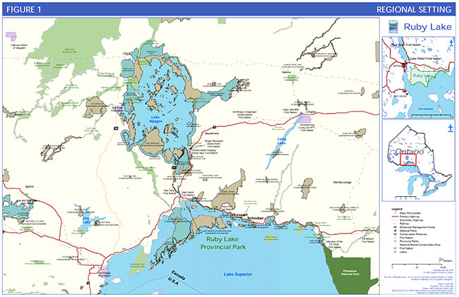
Enlarge Figure 1: Regional Setting
Figure 2: Adjacent Land Use
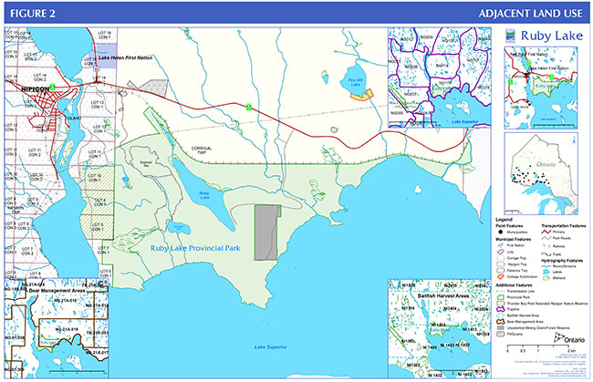
Enlarge Figure 2: Adjacent Land Use
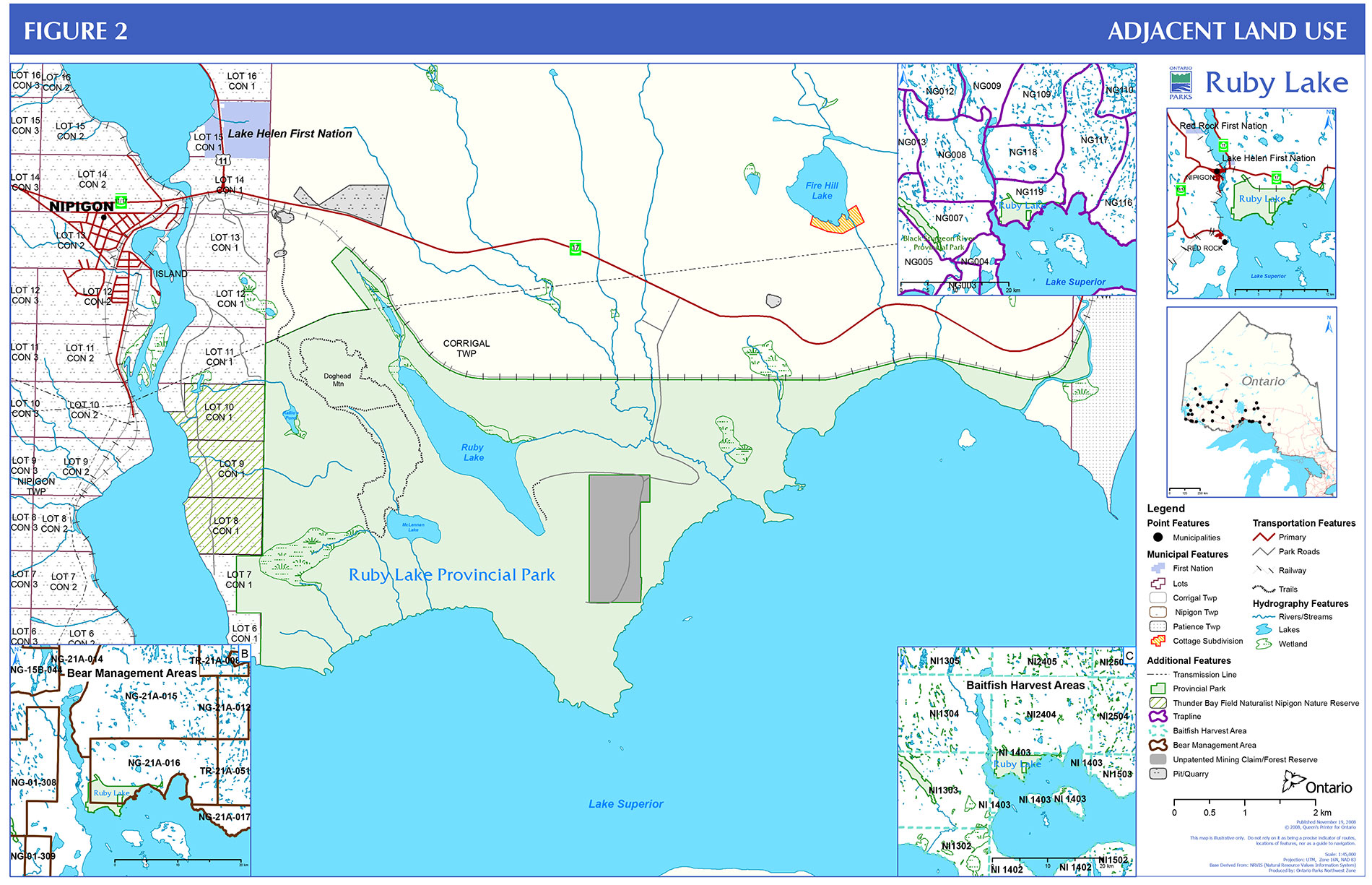
Figure 3: Park Zoning and Development

Footnotes
- footnote[1] Back to paragraph Ruby Lake Park Management Plan has been developed in accordance with the Ontario Provincial Parks Planning and Management Policies (1992), Ontario’s Living Legacy Land Use Strategy (1999) and District Land Use Guidelines for the Ministry of Natural Resources Nipigon District (1983). In accordance with this plan, MNR will amend affected area-specific land use policies and mapping found in the Crown Land Use Policy Atlas.
- footnote[2] Back to paragraph bald eagle (Haliaeetus leucocephalus) - special concern, peregrine falcon (Falco peregrinus) – threatedned, as designated by MNR on its Species at Risk in Ontario (SARO) list Regulation under Ontario’s Endangered Species Act.
- footnote[3] Back to paragraph Rock climbing and scrambling may cause disturbance to these provincial species at risk during important life stages such as nesting and fledging. Both bald eagle and peregrine falcon are regulated endangered species protected under the Ontario Endangered Species Act: Prohibited Acts 5.No person shall wilfully, (a) kill, injure, interfere with or take or attempt to kill, injure, interfere with or take any species of fauna or flora; or (b) destroy or interfere with or attempt to destroy or interfere with the habitat of any species of fauna or flora declared in the regulations to be threatened with extinction. R.S.O. 1990, c. E.15, s. 5.