Samuel de Champlain Provincial Park Management Plan
This document provides policy direction for the protection, development and management of Samuel de Champlain Provincial Park and its resources.
© 1990 Queen’s Printer for Ontario Printed in Ontario, Canada
Single copies of this publication can be obtained from the Ontario Ministry of Natural Resources, North Bay District Office, P.O. Box 3070, Hwy. 63, North Bay, Ontario, P1 B 8K7, telephone 705-474-5550.
ISBN 0-7729-2092-3
Approval statement
We are pleased to release this management plan for Samuel de Champlain Provincial Park as proposed policy for its management and development. The plan reflects this Ministry’s intent to protect the natural, cultural, and recreational values of Samuel de Champlain Provincial Park and to maintain high quality opportunities for outdoor recreation and heritage appreciation for residents of Ontario and visitors to the Province.
M. A. Klugman
Regional Director
Northeastern Region
Norm R. Richards
Director
Parks and Recreational Areas Branch
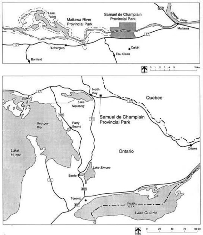
Figure 1: Samuel de Champlain Provincial Park Regional Setting
1.0 Introduction
Samuel de Champlain Provincial Park is located on Highway 17 approximately 50 kilometres east of North Bay and 340 kilometres north of Toronto (Figure 1). The park lies in the valley of the historic Mattawa River, which for countless years, was a major water highway for Native Indians, explorers, and voyageurs. Park operation with camping began in 1960; it was formally opened in 1962, and finally established in legislation in 1967.
Samuel de Champlain Provincial Park consists of 2,550 hectares (ha) on the southern Canadian Shield. The outstanding landform feature within the park is a segment of the Mattawa River Fault, a 600 million-year-old break in the earth’s crust. The fault runs east-west bisecting the park with half of the park on the north side of the Mattawa River and half on the south side. Lands on the north side are dominated by large rolling hills, while the south side is characterized by gentler lowlands. The forest cover is generally a mixture of northern and southern plants, typical of the Great Lakes-St. Lawrence Forest Region. Area wildlife is quite rich in species reflecting the diversity of vegetation and the significance of the Mattawa valley as a distribution corridor for plants and animals. Major attractions and recreation associated with the park include a nationally significant historic canoe route, a voyageur canoe exhibit, good cross-country skiing, significant natural features for backpacking and sight-seeing, excellent canoeing, and two camp grounds comprising of 216 campsites. Other recreation associated with the park includes fishing, swimming, picnicking, and motorboating.
2.0 Management planning
The Samuel de Champlain Provincial Park Management Plan provides policies that will guide the orderly development and effective management of the park over the next 20 years.
Samuel de Champlain Provincial Park began operating with camping in 1960; it was formally opened in 1962, and finally established in legislation in 1967.
Background information on management planning for Samuel de Champlain Park was compiled in 1984, and the preliminary management plan was released for public review and Comment in June 1986.
This management plan has been developed in accordance with guidelines as set out in the Ontario Provincial Parks Planning and Management Policies and the North Bay District Land Use Guidelines.
3.0 Classification
Samuel de Champlain Provincial Park is classified as a natural environment park in the Ontario provincial park system (one of six classes of Ontario’s provincial parks). This recognizes its significant natural and cultural features and its capacity to provide a diverse range of recreational opportunities. Provincial Park Policy states that "natural environment parks incorporate outstanding recreational landscapes with representative natural features and historical resources to provide high quality recreational and educational experiences".
4.0 Goal
The goal for Samuel de Champlain Provincial Park is:
"to maintain and manage the outstanding recreational landscapes with representative natural features and historical resources to provide high quality recreational and educational experiences."
5.0 Objectives
The objectives of Samuel de Champlain Provincial Park are:
"to contribute to the achievement of Ontario provincial park objectives: protection, recreation, heritage appreciation, and tourism."
The following outlines the objectives for protection, recreation, heritage appreciation, and tourism.
5.1 Protection
The protection objective of Samuel de Champlain Provincial Park is:
"to maintain and manage the environment of the park to protect its natural, cultural, and recreational values".
All of the lands within Samuel de Champlain Provincial Park have been directly affected by the glaciers of the last ice age. With the retreat of the glaciers, most of the bedrock outcrops and glacial deposits were worked by glacial melt water. Glacial Lake Algonquin and post Algonquin phases of the early Upper Great Lakes flooded the region for about a thousand years beginning about 11,500 years ago. Approximately 10,500 years ago, the Mattawa valley, with the further retreat of glacial ice, became a major drainage outlet for several early systems of the Great Lakes. Evidence of a large prehistoric river is widespread in the valley. This ancient river flowed west to east, as the Mattawa River does today. The the main transportation corridor between the St. Lawrence settlements and the interior of the North American continent.
The park includes many different natural and cultural areas including 10 areas identified as having particular significance (Figure 2). The Campion Rapids, which was a portion of a historical portage, is a significant archaeological site. The most representative forest landscape in the park, an upland pine and aspen forest, provides a scenic and historic setting for high quality, low intensity recreational and interpretive activities. Other significant areas include a bog with associated bog vegetation bordering Gem Lake; the delta at the confluence of Amable du Fond River and Pautois Creek; Long Lake; the cliffs on the Mattawa River just north of Long Lake; a perched bog at the summit of the highest hill in the park; and the Mattawa winter deer yards, which are partially found within the western section of the park.
5.2 Recreation
The following recreation objectives of Samuel de Champlain Provincial Park are:
"to provide day use opportunities in areas of outstanding recreational potential associated with natural environments"; and
"to provide facility-based camping opportunities in natural environments and in associated areas of outstanding recreational potential."
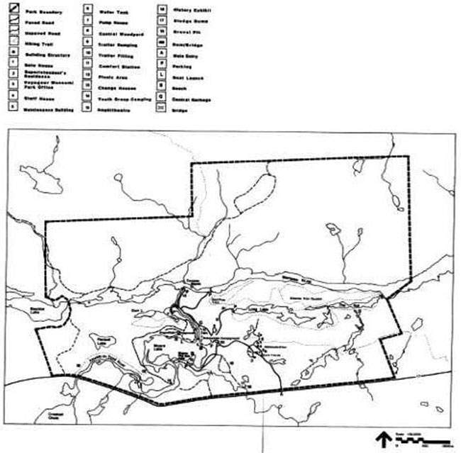
Day use and car camping is centred on Moore Lake (Figure 3). The campgrounds function as a significant stopover and destination for travelers and vacationists and the picnic area is a popular day use site for local people. The park offers 23,500 picnicking and 62,500 car camping opportunities annually. Also provided are a group camping area not far from the main beach, a hiking trail system, and a canoe route. Other opportunities for day users are cross-country skiing, historic interpretation, and backcountry recreation.
The North Bay District Land Use Guidelines indicate that the supply for day use and car camping opportunities are sufficient for the North Bay District provincial parks until the year 2000. However, additional backcountry travel and camping opportunities are required.
The north half of Samuel de Champlain Provincial Park has the potential to contribute to the District’s backcountry travel and camping target. Trail side hut-to-hut hiking and camping with the use of simple cabins will be considered for the north half of the Mattawa River fault, a steep-sided rift in the earth’s crust, also served for several hundred years as part of park. An evaluation will be carried out to determine the suitability and numbers of cabins that could be provided.
As a result of these proposals, an additional objective of the park will be:
"to provide natural environment backcountry travel and camping Opportunities."
Samuel de Champlain Provincial Park emphasizes natural environment based experiences that provide "individuals, families, and small groups with a low-intensity contact with fellow recreationists" and a recreational experience "characterized by solitude, challenge, and personal integration with nature derived from relatively unmanipulated landscapes". The area of the park best suited to satisfying these objectives is in the largely undeveloped northern half.
5.3 Heritage appreciation
The following heritage appreciation objectives of Samuel de Champlain Provincial Park are:
"to provide opportunities for unstructured exploration and appreciation of the natural environment heritage of the park"; and
"to provide opportunities for exploration and appreciation of natural and cultural environments through interpretation and education".
The cultural heritage of the Mattawa River valley is the major theme of the park. Opportunities for both individual (self-guided) and structured (organized) interpretation are available. A Voyageur Museum, which houses an authentic 12 metre replica of a freight canoe along with interpretive displays of voyageur life, is an excellent means to foster appreciation for the fur trade heritage. Information concerning significant earth and life science features, historical resources, and other park values will also be provided through the visitor services program in the form of leaflets, signs, exhibits, guided hikes, and audio-visual presentations.
The park will encourage both unstructured and structured exploration and appreciation of the natural and cultural heritage of the Mattawa and Amable du Fond River valleys to the extent compatible with the protection of these resources.
The Mattawa River was designated as a Canadian Heritage River in 1988 by the Canadian Heritage Rivers Board in recognition of its natural qualities, historical significance, and recreational opportunities. Management will be directed at protecting these natural and cultural heritage values.
Figure 2: Samuel de Champlain Provincial Park Significant Areas
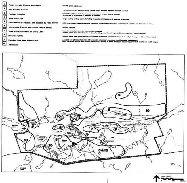
Figure 3: Samuel de Champlain Provincial Park Existing Development
5.4 Tourism
The tourism objective of Samuel de Champlain Provincial Park is:
"to provide Ontario residents and out-of-province visitors with opportunities to discover and experience distinctive regions of the province."
Samuel de Champlain Provincial Park will provide day use and camping opportunities to travelers in Ontario and destination camping opportunities to travelers attracted from large distances. The tourism thrust of the park will be to support the continued viability of the local tourist industry. The voyageur theme will be the main component of this thrust.
6.0 Zoning
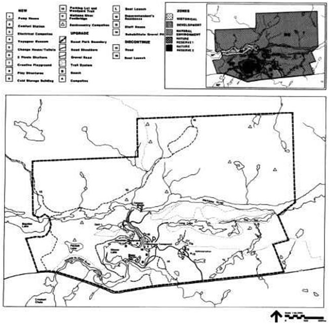
Four zones have been designated to guide the management of Samuel de Champlain Provincial Park: nature reserve, natural environment, development, and a historical zone (Figure 4).
6.1 Nature Reserve Zones (32 ha)
"Nature reserve zones include significant earth and life science features, which require management distinct from that in adjacent zones".
Two areas are representative of significant earth and life science features.
Nature reserve zones will protect their integrity, given their proximity to high intensity use areas of the park. An absolute minimum of development will be permitted and may include trails, signs, minimal interpretive facilities, and temporary facilities for research and management. Management will be directed to the achievement of protection, heritage appreciation, and scientific research.
Nature Reserve Zone NR1 (12 hectares) encompasses two sub-areas southwest of Long Lake. The two areas are separated by a park road to Long Lake. One area contains a bog with excellent primary succession sequence containing virginia chain fern, which is at its northern limit in this area; and the other area is significant for a hybrid of wild rye and bottle bush. For management purposes, i.e. vegetation management, road grading, ditching, etc., an eighteen metre wide road corridor will be excluded from NR1 Zone.
Nature Reserve Zone NR2 (20 hectares) is that portion of the park that encompasses part of the delta area at the confluence of Amable du Fond River and Pautois Creek where they enter Moore Lake. This sensitive delta area contains important wildlife habitat and aquatic vegetation.
6.2 Natural Environment Zones (2108 ha)
"Natural Environment Zones include aesthetic land-scapes in which there is a minimum of development required to support low-intensity recreational activities."
This zone designation encompasses the remaining significant areas and is intended to provide protection and management activities to support low-intensity recreation. Development will be limited to backcountry campsites, portages, trails, signs, minimal interpretive facilities, and other ancillary facilities. Utmost care will be directed at minimizing the disturbing of significant areas.
6.3 Development Zone (310 ha)
"Development zones provide access where appropriate for large numbers to the park and facilities and services for day use and camping activities."
This zone provides the main access to Samuel de Champlain Provincial Park and facilities and services for a range of day use and car camping activities. Two campgrounds, a day use area, group camping areas, amphitheater, historical displays, and other interpretive facilities, as well as water recreation facilities are located here. Maintenance and administration, utilities, and other facilities are also located within this zone. Three significant areas also occur within the zone (Figure 2). Part of the delta area at the confluence of Pautois Creek and Amable du Fond River, part of the deer yards, and part of the bog area south and west of Long Lake are sensitive areas, which will be managed for protection and interpretation where appropriate.
New facilities for the zone and other areas are described under the "Development and Policies" section.
6.4 Historical Zone (100 ha)
"Historical zones include the significant historical resources of the park in which there is minimum development required to support visitor exploration and appreciation and scientific research."
The historical zone is that portion of Samuel de Champlain Provincial Park, which includes a section of the Mattawa River from the western boundary of the park to the foot of the Campion Rapids and a strip of land on both sides of the river 122 metres in width measured perpendicularly to the shoreline.
This section of the river, which contains rapids and historic portages, is immediately next to a historical zone of the Mattawa River Provincial Park.
Development will be limited to trails, necessary signs, interpretive, educational, research, and management facilities, and means of conveyance appropriate to the historical restoration or reconstruction where appropriate. Backcountry campsites, portages, and signs necessary to backcountry travel in the park will be permitted.
7.0 Resource management policies
Samuel de Champlain Provincial Park will be managed according to the planning and management policies for natural environment class provincial parks, the approved park management plan, and minimum operating standards. A park operating plan, which will be consistent with the provincial operating standards, will be kept current to implement and guide the specific operational aspects of managing the park’s natural and cultural resources.
Although the policies herein are presented in separate categories, planning and management recognizes that the components are inter-related and that an integrated resource management approach is required to achieve overall park objectives.
7.1 Vegetation
Vegetation in the park will be managed to fulfill protection and recreation objectives. A vegetation management plan has been prepared for the campground areas to ensure the maintenance of a successional (regenerating) tree and shrub cover. Priorities will be to rehabilitate the Bagwa Road gravel pit and to undertake large scale planting within Babawasee Campground including a buffer between the campsites and the main campground road.
Campsites will continue to be monitored for over-mature or unhealthy trees (hazard trees), and replacement planting will be carried out. Generally, trees will be removed either if there is a threat to public safety and property or where it is necessary to meet the park’s protection and recreation objectives. In the development zone, trees may be removed for development and management purposes. Where trees are removed for these purposes, they may be used for firewood.
Vegetation control will be permitted where necessary for public utilities and rights-of-way.
Spraying of poison ivy in the area of campsites, trails, and other frequented areas will be carried out where necessary. Care will be taken to use the safest available herbicide and to do minimal damage to adjacent vegetation.
Insects and diseases will be subject to control in all zones (except nature reserve zones) where aesthetic, cultural, or natural values are threatened. Where control is necessary, it will be directed as narrowly as possible to the specific problem so as to minimize effects on other components of the park environment. Sprayin g will follow guidelines established by the Ontario Ministries of Natural Resources and the Environment. Biological controls will be used in preference to chemicals where feasible.
All forest fires occurring within the boundaries of the park will be assessed and acted on in accordance with the approved park management plan and fire management area plan to ensure park objectives are met.
Protection from fire will be provided in all cases where life and property are threatened.
7.2 Water
Water quality will be monitored by the Ontario Ministry of Natural Resources to ensure human health and safety. Motorboats and outboard motors will be prohibited on Long Lake, which is the source of drinking water for the park. The water level on Moore Lake (three bathing areas) will be maintained by the existing dam, and boat motors of more than 7.5 kilowatts (10 horsepower) will be prohibited.
7.3 Fisheries
Sportfishing will be encouraged. The fishery will continue to be managed in accordance with policies and regulations prevailing in the area. Specific management direction will be provided through North Bay District Fisheries Management Plan to ensure quality angling. Long Lake will continue to be stocked with yearling brook trout. Non-native fish species will not be introduced, and the use or possession of live bait fish will be prohibited in Long Lake, Coco Lake, Gem Lake, and Pacaud Lake. Commercial fishing will not be permitted.
7.4 Wildlife
In accordance with the Provincial Parks Policy and public input, hunting will not be permitted within Samuel de Champlain Provincial Park. Commercial trapping will be phased out in the park in a manner least harmful to the existing trapper. The phase out will occur over a 21 year period from December, 1988 or when the trapper retires or dies, whichever is sooner. Hunting or trapping required in the control of animal populations or nuisance and diseased animals will be carried out under the strict supervision of, or directly by, the Ontario Ministry of Natural Resources.
A wildlife management plan will be produced and implemented with the assistance of the Fish and Wildlife staff of the Ontario Ministry of Natural Resources. The objective of the Wildlife Management Plan will be to protect wildlife to foster wildlife viewing and heritage appreciation.
7.5 Mineral exploration
Mineral exploration and mining will not be permitted within Samuel de Champlain Provincial Park.
The extraction of aggregate will not be permitted except for park purposes. When aggregate extraction is terminated, the pit will be rehabilitated through grading and vegetation.
8.0 Operations policies
A Park Operations Strategy will be prepared to provide staff with the necessary operational information to carry out day-to-day park operations. The strategy will also address budgeting, staffing, maintenance schedules, enforcement, and emergency services. The provisions of the strategy will be consistent with the approved Ontario Provincial Park Operating Standards and will be reviewed annually and updated as required.
8.1 Visitor services
Visitor services will be managed in accordance with the park management plan. The park visitor services plan will outline specific guidelines for visitor services management with the intent to assist park visitors in achieving maximum enjoyment and benefit while visiting the park during the operating season.
8.1.1 Public information
Information concerning park resources, management, facilities and programs, and nearby points of interest will be available at key points throughout the park such as the park office, gatehouse and the voyageur museum, etc.
8.1.2 Interpretation
A visitor services plan will be prepared to ensure ample opportunities for visitors to gain an understanding and awareness of, and an appreciation for, the park’s policies, management objectives, and the natural, cultural, and historical resources. In addition, the programs will promote Mattawa River Provincial Park.
The interpretive component will seek to create an understanding of the natural attributes of Samuel de Champlain Provincial Park. The main interpretive theme is the historical and present use of the Mattawa River as a transportation corridor, which served native people, early explorers, missionaries, voyageurs, loggers, settlers, and now present day recreationists. Other interpretive themes include the significance of the valley as a geological fault, drainage outlet for the early Great Lakes and distribution route for plants and animals.
Self-use interpretive facilities (signs, displays, plaques, pamphlets, leaflets, and special publications) deliver park information, resource interpretation, and park management messages.
A voyageur museum has been established in the vicinity of the gatehouse to cover natural, cultural, and historical resource information about the park, the Mattawa River, and the surrounding area.
8.1.3 Recreation
Recreation management for Samuel de Champlain Provincial Park will be in accordance with the approved park management plan.
Day use, facility based camping, and backcountry camping activities will be based on interaction with the natural environment and appreciation for the natural and cultural values.
Recreation management in the natural environment zone will be directed toward low-intensity backcountry camping and day use activities such as hiking, canoeing, swimming, fishing, cross-country skiing, etc. Backcountry users will be required to pack out all non-burnable garbage, and management activities will be directed at maintaining minimum standards for cleanup and general maintenance of portages and trails.
8.1.4 Research
Scientific research by qualified individuals, which contributes to the knowledge of natural and cultural history and to environmental and recreational management, will be encouraged in the park. The Ontario Ministry of Natural Resources will encourage institutions to undertake research projects. Additional ecological surveys will be required to refine zoning and management prescriptions. A life science report for Site Region SE, which is currently being prepared, may determine additional areas for nature reserve zones or redefine existing nature reserve boundaries. All research programs will require the approval of the Ontario Ministry of Natural Resources and will be subject to Ministry policy and other applicable legislation. The Ontario Ministry of Natural Resources may approve the removal of any natural or cultural specimen by qualified researchers. All such materials removed remain the property of the Ontario Ministry of Natural Resources.
Approved research activities and facilities will be compatible with the protection objective. Any site, which is affected, will be rehabilitated as closely as possible to its original state.
8.1.5 Marketing
Samuel de Champlain Provincial Park will continue to be marketed as a distinctive natural area having high recreational value and historical importance. The park will be marketed through its visitor services program, and marketing will endeavor to increase visitation through the following objectives: increase the length of stay, attract day users staying at commercial establishments, attract campers and day users during low use periods in the mid-week and shoulder seasons, promote local tourist services and attractions, and generally promote interaction between the park and the commercial sector.
Marketing will be aimed at designated user groups through such means as brochure distribution, radio, newspapers, television, posters, special events, etc.
9.0 Development policies
Development will proceed in accordance with zone policies of this approved park management plan, management policies, provincial park development standards, and approved development plans. In all instances, approved, detailed site plans will precede all development (Figure 4). The requirements of the Environmental Assessment Act and other pertinent acts will be adhered to.
All new development will be proposed through work program planning and/or special funding initiatives.
9.1 Camping facilities
Samuel de Champlain Provincial Park will continue to offer 216 campsites: 74 sites in Babawasse Campground and 142 sites in Jingwakoki Campground. No new campsites will be developed in the foreseeable future. Campsite rehabilitation will be carried out to ensure that all campsites are maintained at standards recommended by park development guidelines. A vegetation management plan has been prepared to establish a program of sustained successional tree planting in the campgrounds and to maintain adequate buffers between individual campsites and between campsites and park roads. The need for a comfort station in Jingwakoki Campground has been established. Although plans will be prepared, construction will be dependent on future funding.
Showers
Camper surveys indicate that showers are at the top of the list of necessities. To satisfy this need, plans have been prepared to provide a shower annex to the Babawassi Campground comfort station and to construct a new comfort station with showers in Jingwakoki Campground.
Electrical campsites
Observations and surveys have shown that electrified campsites are frequently requested by the public. Presently, the park cannot accommodate many of the modern camping units that require electrical hook-ups. Plans will therefore be prepared to convert Babawasse Campground into electrical campsites providing up to 74 electrified sites.
Group campground
The present group camping area will continue to be accessed by a separate vehicular road off Highway 17 just west of the main park entrance. Pedestrian access between the group campgrounds and the day use area will be maintained. A youth group camping area has been established along the Amable du Fond River. Access is gained along the park emergency exit.
Backcountry facilities
The northern portion of the park will be assessed to determine numbers and specific locations for backcountry campsites and trail alignment. Pedestrian access from the main development area to the northern part of the park will be facilitated by a pedestrian bridge across the Mattawa River. A study will be carried out to determine a specific site for such a bridge.
9.2 Day use facilities
Samuel de Champlain Provincial Park has an excellent and popular day use picnic area with potential for increased use, particularly with residents and local tourist accommodations (North Bay, Mattawa). In recognition of this, planning efforts will be directed to improving and expanding existing facilities.
Figure 4: Samuel de Champlain Provincial Park Proposed Development and Zoning
Picnic area
The main day use area on Moore Lake will continue to be an important attraction at Samuel de Champlain Provincial Park. To enhance day use, plans will be prepared to develop picnic shelters, a new change house / toilet facility, and a creative playground. Improvements (grading and additional beach sand) will be made to both the dry and wet areas of the beach. Improvements will also be made to the two campground beaches including an expansion of the existing play structures.
Boat launching
The boat launching facilities at Jingwakoki Campground, Long Lake, and below Ca mpion Rapids will continue to be maintained while the one at Babawasee Campground will be phased out.
Trails
All existing hiking trails in the south half of the park will continue to be maintained, and new trails will be planned for the north half to facilitate backcountry recreation. Some brushing of existing trails and the installation of additional trail markers will promote a more safe, self-use trail system. A trails plan dealing with rehabilitation and maintenance of existing trails and design guidelines for future trails will be prepared.
9.3 Roads and access
All existing roads (gravel surface and asphalt pavement), which service the campgrounds, day use area, group camping areas, boat launch sites, and maintenance / operational facilities, will be maintained within provincial park road standards. The park emergency exit road and deteriorating shoulders of the asphalt roads will receive additional granular material and regrading. Road improvements (granular treatment) will also be undertaken in both campgrounds. A new parking lot will be located on the main park road to provide a more centralized and convenient access to the existing wood yard.
9.4 Other improvements
The need to undertake the following projects has been established: re-cut the park boundary for better definition, redecorate and upgrade the Park Superintendent’s residence, upgrade or replace the existing inadequate staff house, and construct a cold storage building (unheated structure for material and equipment storage).
10.0 Implementation
Implementation of this approved management plan will involve updating the operating plan on an ongoing basis, undertaking resource management plans and re-carrying out visitor services planning. Development of approved facilities will be based on work program planning and funding proposals through the North Bay District Office. Ecological surveys will also continue to be carried out to expand the park resource information base. These surveys will be necessary to refine zoning and management prescriptions.
Following is a summary of proposed projects and improvement that have been identified within the background information and addressed by this plan. The projects have been separated into two lists.
Operational and minor capital projects - normally funded through work program planning and capital project funding. Many of these projects may also be achieved through special work programs.
Major capital projects - usually funded through special funding programs that often include external funding.
10.1 Operational and minor capital projects
Bagwa Picnic Area
- two new mini picnic shelters
- creative playground structure
- upgrading beach for wet beach improvements
Campground areas
- replacement of privies
- extensive tree planting
Babawasse campground
- campsite upgrading - scarification, topsoil, and tree planting
- road upgrading - additional granular material
- beach improvements (additional beach sand) Jingwakoki and Babawasse Campgrounds
- expansion of play area and structures on each campground beach
- remove boat launch - Babawasse Campground
- installation of vehicular control gates - both campgrounds
Note: A vegetation management plan has been prepared focusing on campgrounds.
Administration / operational facilities
- upgrade boat launch facility on Mattawa River
- upgrade shoulders of asphalt roads
- upgrade existing trails
- new parking and access to existing wood yard
- upgrade Superintendent’s residence (doors & windows)
- upgrade emergency exit road
- re-cut park boundary
10.2 Major capital projects
- shower additions to existing comfort station
- Babawasse Campground
- comfort station with showers - Jingwakoki Campground
- electrical campsites - Babawasse Campground
- combination change house / toilets - Bagwa Picnic Area
- hiking trails and backcountry campsites on north side of park
- upgrade or replace staff house
- cold storage building for maintenance area.
11.0 Plan review
This park management plan will be reviewed on an ongoing basis throughout its 20 year lifespan, but an official review will be carried out in ten years. The review will be carried out in the following manner.
- review initial management planning process
- update background information and data on park resources and use
- review plan implementation and provincial policies
- identify new issues or concerns
- prepare issues and solutions document for public review
- review public comments
- prepare and receive approval for plan amendments
12.0 Public consultation
This park management plan is a result of a continuing consultation process that has considered the needs, desires, and opinions of a variety of interests. It attempts to achieve balance economically, socially and environmentally in the Ontario Ministry of Natural Resources approach to the management of Samuel de Champlain Provincial Park for both now and in the future.
Public involvement in the management plan first began during the spring of 1986 with news releases requesting public participation in two open house presentations scheduled for the following summer. These presentations were held in North Bay, Bonfield, and Mattawa, July 9,10, and 11,1986. In June of 1986, copies of the preliminary management plan were mailed directly to interest groups, other government ministries, and adjacent property owners. Comments were requested to be submitted within 30 days to the District Manager in North Bay. Copies of all comments received are available for viewing at the North Bay District Office.
During public consultation, the Ontario Ministry of Natural Resources examined the appropriateness of allowing hunting in the north half of the park. The decision on whether or not hunting would be allowed in the park was based on:
- public input
- recreational targets recommended by the North Bay District Land Use Guidelines
- land use requirements within the park to meet the recommended targets; and
- direction provided within the Ontario Provincial Parks Planning and Management Policies
On the basis of the Ministry’s evaluation and input received from the public, it has been decided that hunting will not be a permitted use within Samuel de Champlain Provincial Park.
In applying this park management plan, the Ontario Ministry of Natural Resources is committed to continuing this consultation with government agencies, other minis tries, interest groups, and the public, It is important that the channels of communication that have been created by this consultation process be maintained.
13.0 Select references
Billings, M. D., 1974. Mattawa and ChamplainProvincial Park Earth Science Report. Ontario Ministry of Natural Resources, Northeastern Region (Sudbury).
Cuddy, D. G., 1974. Mattawa and ChamplainProvincial Parks Life Science Report. Ontario Ministry of Natural Resources, Northeastern Region.
Halloran, J., 1971. The History of the Mattawa Wild River Park. Ontario Ministry of Natural Resources.
Ontario Ministry of Natural Resources 1981 a. Background information North Bay District. Northeastern Region. District Land Use Planning Emgram. (Phase 1).
Ontario Ministry of Natural Resources, 1982b. Guidelines for Preparation of Wildlife Management Plans for Provincial Parks. Unpublished draft.
Ontario Ministry of Natural Resources, 1977a. Hunting in Provincial Parks. Unpublished discussion paper. Systems Planning Section, Parks Planning Branch, Toronto.
Ontario Ministry of Natural Resources, 1984. Mattawa River and Samuel de Champlain ProvincialParks Management Plan Background Information.
Ontario Ministry of Natural Resources, 1978b. OntarioProvincialParksPlanningand Management Policies. Toronto.
Ontario Ministry of Natural Resources, 1978a. OntarioProvincial Parks Policy. Toronto
Ontario Ministry of Natural Resources, 1981b. Provincial ParksWildlifeManagement. Policy paper (P.P.O. 30)
Ontario Ministry of Natural Resources, 1980b. Samuel de Champlain and Mattawa River Provincial Parks Management Plan. Unpublished report.