Sandy Islands Provincial Park Management Statement
This document provides policy direction for the protection, development and management of Sandy Islands Provincial Park and its resources.
Interim Management Statement
2006
Approval statement
I am pleased to approve this Interim Management Statement for Sandy Islands Provincial Park. Ontario’s Living Legacy Land Use Strategy (OMNR 1999) designated this as a nature reserve class provincial park. It was regulated in April of 2001 under Ontario Regulation 85/01.
This Interim Management Statement provides direction for the protection and custodial management of Sandy Islands Provincial Park.
Signed by:
Paul Bewick
Zone Manager
Northeast Zone
Ontario Parks
Date: May 26, 2006
1.0 Introduction
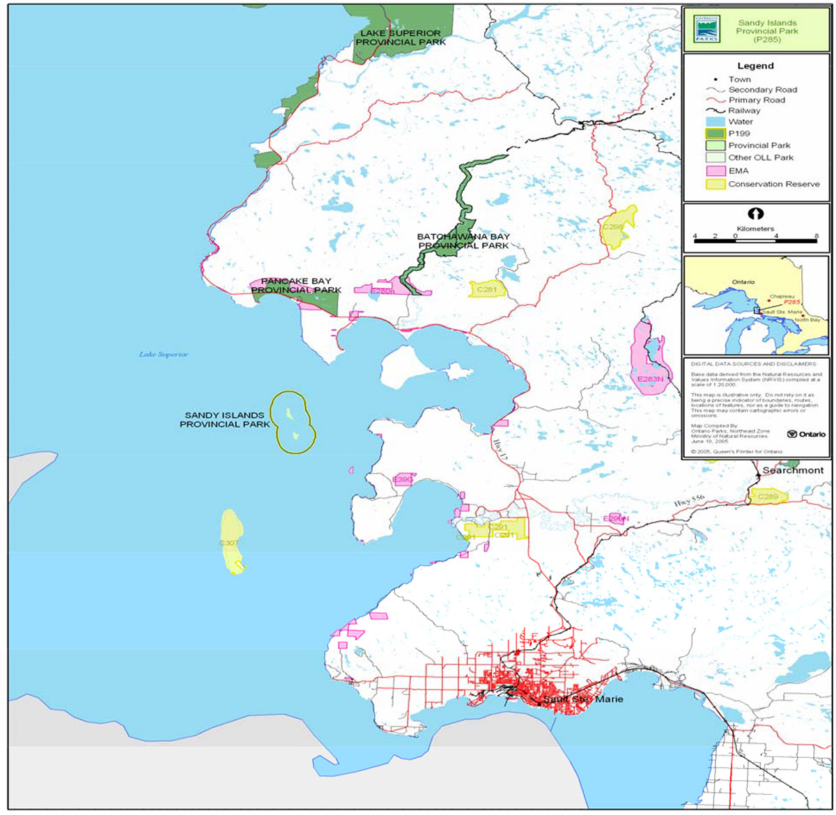
Sandy Islands Provincial Park is located offshore in Lake Superior at the mouth of Batchawana Bay. The park is approximately 40 km northwest of Sault Ste. Marie and 7 km due south of Pancake Bay Provincial Park (Figure 1). Sandy Islands Provincial Park was regulated as a nature reserve class park in April 2001 (O. Reg. 85/01). This classification recognizes the park’s provincially significant geological and biological features.
The park consists of North and South Sandy islands, Steamboat Islet and the surrounding shallow shoals to an offshore limit of 1.6 kilometres. The park encompasses 2,477 hectares of land and water (Figure 2). The area is protected for its intrinsic value as well as for educational and research purposes to benefit present and future generations.
1.1 Objectives
Sandy Islands Provincial Park will be managed in accordance with the two main objectives for nature reserve class provincial parks:
Protection: To protect provincially significant elements of the natural and cultural landscapes of Ontario.
Heritage Appreciation: To provide opportunities for exploration and appreciation of the outdoor natural and cultural heritage of Ontario.
2.0 Management context
This Interim Management Statement (IMS) provides direction for custodial management of park resources. The direction for resource stewardship, permitted uses, development and operations will be reviewed during future management planning as required.
Park management will follow direction from:
- Provincial Parks Act (1990), and regulations
- Ontario’s Living Legacy Land Use Strategy (OMNR 1999), policy clarification amendments (OMNR 2000) and related direction
- Ontario Provincial Parks Planning and Management Policies (OMNR 1992) and updates
- Ontario Crown Land Use Policy Atlas (OMNR 2004a) and amendments
In addressing custodial management obligations to protect park values and ensure public health and safety, Ontario Parks will ensure that policy and Environmental Assessment Act (1990) requirements are implemented.
The park superintendent will implement the policies, procedures and legislation that are derived from the above direction and written into this IMS.
2.1 Environmental Assessment
As part of the Ontario Ministry of Natural Resources (MNR), Ontario Parks is a public sector agency that is subject to the Environmental Assessment Act. Park management will be carried out in accordance with legislation, policies and MNR's A Class Environmental Assessment for Provincial Parks and Conservation Reserves (OMNR 2005a).
Figure 1: Regional Setting
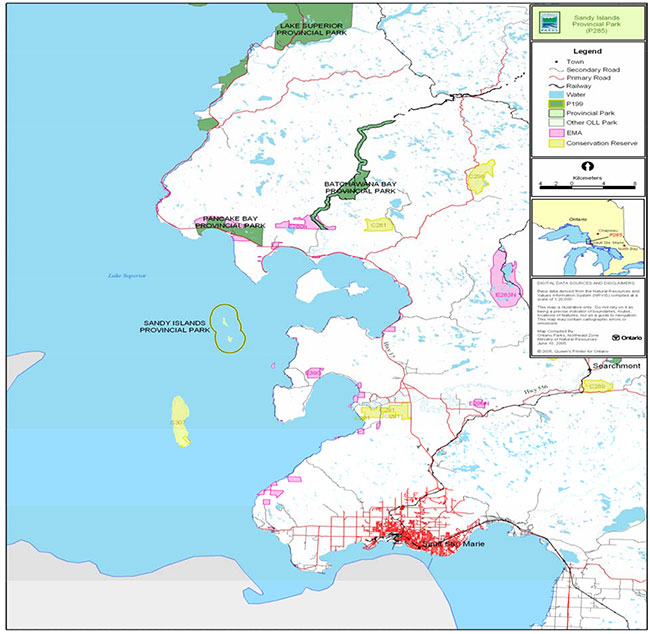
Enlarge Figure 1: Regional Setting
Figure 2: Park Boundary and Features and Values
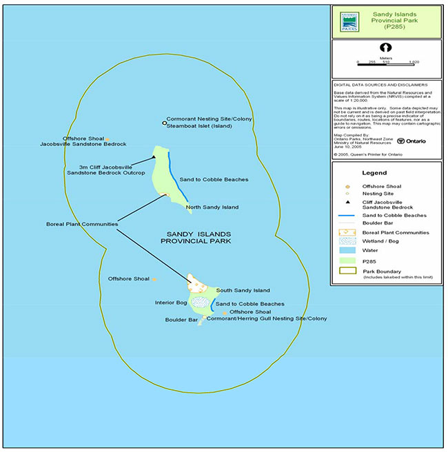
Enlarge Figure 2: Park Boundary and Features and Values
3.0 Park features and values
Representative and special geological and biological features of the nature reserve are provincially significant. Protection is a priority.
Management will allow natural processes to continue to shape the islands and shoal landforms, as well as the ecology of aquatic and terrestrial environments. A resource stewardship plan may be considered if more detailed planning and management direction is required for values of particular concern.
3.1 Geological features
The islands are flat and low-lying, located in Lake Superior approximately seven kilometres south of Corbeil Point, the easterly point of Pancake Bay Provincial Park. Jacobsville sandstone, which is uncommon in Ontario, is the bedrock exposed on the islands and surrounding shoals. An outcrop of the sandstone on North Sandy Island contains some of the best representation of this feature in Ontario. Steamboat Islet is a small bald rock. Both North Sandy and South Sandy islands contain fine sand beaches derived from the weathering of local sandstone. This is a unique feature of the park, having the source area of eroding sand that accumulates in the dynamic coastal beaches on the islands.
3.2 Biological features
The flora and fauna of the park is representative of small sandy islands in Ecodistrict 5E-13 (Crins 1996). White birch with some balsam fir is the dominant island forest ecotype. Small patches of yellow birch, red maple, sugar maple and eastern white cedar are present on both islands. A large portion of South Sandy Island contains shallow organics over the sand that support typical bog communities of leather leaf, bog rosemary, sedges and sphagnum mosses. In addition, the small dynamic sand dunes on the leeward side of both islands harbour grass communities.
Double Crested Cormorant and Herring Gull nesting colonies are found on the south tip of South Sandy Island, with cormorants also found on Steamboat Island.
3.3 Cultural setting
No detailed survey or analysis of the park’s cultural history has been conducted to date.
Future planning for cultural heritage will be done within the context of the provincial framework, A Topical Organization of Ontario History (OMNR 1974). Planning will also involve updates and discussions with other agencies, First Nation communities and interest groups to identify cultural heritage values and features, and their significance, within the park. This information may be used to develop management guidelines to conserve and protect representative archaeological or historical values and features, and to provide direction for further research.
There is little sign of use on the islands, with the exception of evidence of infrequent campfire disturbance and one small cabin as noted in background surveys (Crins 1996).
"… the lake is rarely like glass and so there are fishing camps on the islands… fishermen waiting for rough conditions to subside. On North Sandy’s west side, ribs of a wrecked steamer stick up just below the water’s surface…"
(Chisholm and Gutsche 1999).
3.4 Recreation
The protection and maintenance of environmental quality and values are fundamental to the management of Sandy Islands Provincial Park. Nature reserve policies ensure that natural processes are allowed to function freely, within the constraints of public safety and the need to protect values within and adjacent to the nature reserve.
People may travel to the Sandy Islands nature reserve class provincial park to see a representative natural area and special landscape within the Superior Structure Province of the Canadian Shield and Ecodistrict 5E-13. Typically, visitors are interested in these islands because they offer a remote, undeveloped recreational setting. Low-intensity recreational activities such as boating, fishing, nature appreciation, natural history exploration and education may continue, provided they do not harm the features that are being protected.
4.0 Aboriginal uses
Sandy Islands Provincial Park is within the Robinson-Huron Treaty area (1850) and is located northwest of the Batchawana Indian Reserve.
First Nations have expressed interest in and have shared knowledge of the park and surrounding area. Aboriginal communities have used the area for hunting, trapping, fishing, gathering and travel. These uses may continue, subject to public safety, conservation and other considerations.
No comments or issues were raised by area First Nations on the park designation in Ontario’s Living Legacy or during the boundary refinement process (OMNR 2001).
Any communications and cooperation between Aboriginal communities and the MNR for planning and operations purposes will be done without prejudice to any future discussions or negotiations between the government of Ontario and Aboriginal communities.
5.0 Stewardship policies
The park will be managed to sustain natural and cultural heritage features and values. Sensitive areas within the park will be recorded and managed appropriately, as they are identified. This may include species at risk such as vulnerable, threatened or endangered species (OMNR 1992).
5.1 Terrestrial ecosystems
Removal, damaging or defacing of Crown property, natural objects, relics and artifacts is not permitted in provincial parks (Provincial Parks Act).
5.1.1 Vegetation
Harvesting
Commercial forest harvesting and renewal activities are not permitted within the boundaries of this waterway provincial park (OMNR 2004a).
The commercial harvesting of non-timber forest products (e.g. wild rice, club moss, Canada yew) will not be permitted within the boundary of Sandy Islands Provincial Park (OMNR 1992; 2004a).
There are no fuel wood cutting permits currently issued within the park. No new permits will be issued (OMNR 2000).
Non-native plants
Non-native plant species will not be deliberately introduced into the park. Where non-native plant species are already established, and threaten park values, a strategy may be developed to control the species (OMNR 1992).
Insects and disease
Insect and disease will not be managed unless there are non-native species and strains that threaten natural values (OMNR 1992). Guidelines established by OMNR and the Ontario Ministry of Environment will be implemented. Biological controls will be used in preference to chemicals, where feasible.
Fire
Sandy Islands Provincial Park is located within the Great Lakes- St. Lawrence Zone for forest fire management. In accordance with existing provincial park policy and the Forest Fire Management Strategy for Ontario (OMNR 2004b), forest fire protection will be carried out. As the Sandy Islands make up a small land base and are located offshore in Lake Superior, fire management will not be a priority.
Whenever feasible, MNR's Fire Management program will use techniques which minimize damage to the landscape such as limiting the use of heavy equipment or limiting the number of trees felled during response efforts (OMNR 2004b).
5.1.2 Wildlife management
The Sandy Islands appear to be too small to support populations of game animals. Two colonial nesting sites existed on the islands at the time of writing. There were Double Crested Cormorants with Herring Gulls on the south tip of South Sandy Island and cormorants on the shoals off the north tip of North Sandy Island.
Sandy Islands Provincial Park is located within Wildlife Management Unit 36. Removal or harassment of non-game animals is not permitted in provincial parks (Provincial Parks Act).
Hunting
Wildlife management is in accordance with the Ontario Provincial Parks Planning and Management Policies and Ontario’s Living Legacy Land Use Strategy. As the Sandy Islands and offshore shoals were regulated as a nature reserve class provincial park, hunting is not permitted within the park.
It is illegal to harvest bullfrogs or snapping turtles in provincial parks (OMNR 2004a).
Bear Management Areas
There are no bear management areas within Sandy Islands Provincial Park. No new operations will be permitted. Hunting is not permitted in nature reserve parks (OMNR 1992; 1999; 2000).
Trapping
There are no traplines within Sandy Islands Provincial Park (OMNR 2004a).
Commercial fur harvesting is not permitted in this nature reserve park. No new operations including trap line cabins and trails will be permitted (OMNR 2004a).
5.1.3 Industrial resources
Mineral exploration and mining, aggregate extraction and peat development are not permitted within Sandy Islands Provincial Park (OMNR 2004a).
5.1.4 Access and crossings
The offshore location of Sandy Islands in Lake Superior, given current technologies, precludes issues related to hydro corridors, roads and pipelines.
Access
Boaters visit the Sandy Islands infrequently. Air access may occur under favourable conditions. There is no access infrastructure (i.e. dock) on the islands. There is no intent to establish any infrastructure for access on the islands.
Roads
There are no roads within Sandy Islands Provincial Park.
Utility corridors
There are no utility corridors within Sandy Islands Provincial Park.
Recreational trails
There are no authorized trails within the park. There is no intent to develop infrastructure in this remote nature reserve class park. Priority will be given to protecting the pristine condition of the park’s features and values. If there is a perceived need, new trails (e.g. hiking) may be proposed during park management planning with public consultation. Any proposed development within the park is subject to MNR's Environmental Assessment requirements.
5.1.5 Adjacent land management
As the Sandy Islands are a regulated park completely surrounded by Lake Superior, most issues normally associated with adjacent land use do not affect this park. There may be activities on Lake Superior that have potential to affect Sandy Islands Provincial Park features or values, such as great lakes shipping.
Adjacent recreational features
Sandy Islands Provincial Park can be accessed by boat from along the southeastern shoreline of Lake Superior. Lake access is possible from the mainland opposite Sand Islands. The surrounding waters of Lake Superior are used for recreational boating, sea kayaking and sport fishing.
The Trans Canada Highway offers outstanding views of Lake Superior and the Sandy Islands from various locations. Nearby, Pancake Bay Provincial Park offers day use and overnight camping facilities. A hiking trail in this park offers viewpoints interpreting the natural and cultural features of the area.
5.1.6 Land disposition
No new land disposition for the private use of individuals or corporations will be permitted.
Land use permits, licenses of occupation, unauthorized occupations
There are no existing private recreational camps, cottage lots, land use permits, licenses of occupation or unauthorized occupations within the park.
Patent lands
There is no patent land located within the park.
Boat caches
There are no authorized boat caches within the park. Watercraft are not permitted to be left unattended in the park without written permission from the park superintendent under the authority of the Provincial Parks Act.
5.2 Aquatic ecosystems
5.2.1 Water management
Sustaining quality water resources is integral to the protection of park and related values. The Ontario Ministry of the Environment enforces applicable legislation and regulations for water quality.
5.2.2 Fisheries management
The Lake Superior fisheries management unit will be consulted as required on fishery-related matters. Existing sport fishing may continue within the 1.6 kilometre limit of the park in Lake Superior (OMNR 2000).
Sport fishing
Sport fishing is permitted within Sandy Islands Provincial Park. Sport fishing is governed by the legislation and regulations in the Fish and Wildlife Conservation Act (1997) and the Fisheries Act (1985). The Recreational Fishing Regulations Summary contains details on the regulations that are applicable to this area.
Commercial fishing
There are no commercial fishing operations within Sandy Islands Provincial Park. No new operations will be permitted (OMNR 1992).
Commercial baitfish harvesting
There is no commercial baitfish harvesting areas with in Sandy Islands Provincial Park. No new operations will be allowed (OMNR 2000; 2004a).
Fish stocking
The stocking of fish will not be considered in Sandy Islands Provincial Park due to its nature reserve classification.
6.0 Operations policies
6.1 Recreation management
Future planning, with full public consultation, will review direction on motorized and non- motorized recreation uses.
6.1.1 Motorized recreation
Motorboats
Motorboats travel from the mainland to various sections of Lake Superior in this area. Some motorboats travel through the park. Boat travel may continue in park waters.
Snowmobiles
There are currently no authorized snowmobile trails within the park boundary. No new trails will be permitted.
Off-road use of snowmobiles is prohibited unless authorized by the park superintendent under the authority of the Provincial Parks Act.
All-Terrain Vehicles
There are no authorized all-terrain vehicle (ATV) trails within the park. No new trails will be permitted.
Off-road use of (ATVs) is prohibited unless authorized by the park superintendent under the authority of the Provincial Parks Act.
Aircraft
Aircraft landings are permitted within nature reserve parks within the Ontario’s Living Legacy planning area (OMNR 2004a). All aircraft landings are subject to future management planning and valid aircraft landing permits.
6.1.2 Non motorized recreation
Camping
The initial recreation assessment did not identify any campsites or hiking trails within the park. Overnight camping and the development of campground or campsite facilities are not compatible with nature reserve policies (OMNR 1992).
Camping is associated with persons that infrequently stop on the open beaches of these islands. Sometimes this happens for safe refuge from storms.
Hiking
There are no authorized hiking trails within the boundaries of this provincial park. If there is an identified need, the development of trails will be addressed during future planning, which includes public consultation.
Canoeing/kayaking
Existing uses may continue, unless park values are threatened (OMNR 2004a). Infrastructure to protect park features and values may be permitted and developed in response to use, environmental deterioration and environmental protection requirements.
Beachcombing
Day uses like beach walking, exploring and viewing will continue.
6.1.3 Emerging recreational uses
There are emerging recreational uses for which there is limited or no policy to deal with their management (e.g. adventure racing, geocaching). The park superintendent will use legislation, policy and guidelines that are in place in the interim to manage emerging uses.
6.2 Development
There is no existing development within the park. Infrastructure to protect park features and values may be permitted and developed in response to use, environmental deterioration and environmental protection requirements. Any proposed development within the park is subject to MNR's requirements under the Environmental Assessment Act.
6.3 Commercial tourism
There are no existing commercial tourism facilities in Sandy Islands Provincial Park. New commercial tourism facilities are not permitted within f this nature reserve park (OMNR 2004a).
The park’s values include the pristine condition of features and its remote setting. The park’s remote location on Lake Superior requires that travelers have advanced travel and camping skills. Cold water and sometimes adverse weather conditions (such as violent storms and fog) can make it difficult to get to Sandy Islands or return to the mainland.
Marketing and promotion of the park as a destination is not a priority for this park.
7.0 Cultural resources
No assessment of the park’s cultural resources k has been completed at this time. Management of any cultural features and values within the park will be directed toward protection, research and heritage appreciation (OMNR 1992).
8.0 Heritage education
Literature and other supporting information may be developed to describe the park in the context of Ontario’s provincial park system. Boundary limits, significant heritage features and permitted uses of the waterway park may be included in park literature.
Prospective park visitors may be informed about the sensitivity and significance of park values through park literature.
9.0 Research
Scientific research by qualified individuals which contributes to the knowledge of natural or cultural history, or to environmental or recreational management, may be encouraged in the park. Ontario Parks will encourage institutions, such as universities, to undertake research projects.
All research programs will require the approval of Ontario Parks and are subject to park policy and other applicable legislation. Any materials removed from the park will remain the property of Ontario Parks.
Approved research activities and facilities will be compatible with the park’s protection objective. Any site which is affected by research will be rehabilitated as closely as possible to its original state. Environmental Assessment Act requirements will apply.
10.0 References
Beechey, T., 1980. A Framework for the Conservation of Ontario’s Biological Heritage. Ontario Ministry of Natural Resources, Toronto, 210 p.
Chisholm, B. and A. Gutsche, 1999. Superior Under the Shadow of the Gods. Upper Lakes Group. 279 pp.
Crins, W. J. 1996. Sandy Islands. Life Science Checksheet. 9 pp.
Environmental Assessment Act, 1990.
Fisheries Act, 1985.
Fish and Wildlife Conservation Act, 1997.
Kor, P., 1995. North Sandy Island, South Sandy Island. Earth Science Inventory Checklist. 7 pp.
Kershaw, W.L., 2002. Recreation Assessment Sandy Islands Provincial Park - Version 1.5. A Natural Heritage Area in Ontario’s Living Legacy Land Use Strategy – P285. 12 pp.
Noble, T.W., 1983. Life Science Report 4E, Northeast Region. OMNR, Northeastern Region, Sudbury. 90 pp. Appendices.
Ontario Ministry of Natural Resources, 1974. A Topical Organization of Ontario History. Historic Sites Branch Division of Parks.208 pp.
Ontario Ministry of Natural Resources, 1992. Ontario Provincial Parks Planning and Management Policies, 1992 Update.
Ontario Ministry of Natural Resources, 1999. Ontario’s Living Legacy Land Use Strategy. 136 pp.
Ontario Ministry of Natural Resources, 2000. Ontario Provincial Park Policy as Amended by Ontario’s Living Legacy Land Use Strategy. September 26, 2000.
Ontario Ministry of Natural Resources, 2001. Sandy Islands Public and Aboriginal Consultation Documentation Form: Protected Area Boundary Refinement Review.
Ontario Ministry of Natural Resources 2004a. Ontario’s Crown Land Use Policy Atlas.
Ontario Ministry of Natural Resources. 2004b. Fire Management Strategy for Ontario. Aviation and Fire Management Branch.
Ontario Ministry of Natural Resources, 2005a. A Class Environmental Assessment for Provincial Parks and Conservation Reserves.
Provincial Parks Act, 1990.
Appendix A: Background information
| Name | Sandy Islands Provincial Park (P-285) |
|---|---|
| Classification | Nature Reserve |
| Ecoregion/Ecodistrict | 5E-13 (Batchawana) |
| OMNR Administrative Region/District | Northeast Zone, Sault Ste. Marie District |
| Total Area (ha) | 2,477 hectare |
| Regulation Date | 85/01, April 2001 |
Representation targets
Earth science:
The geology within the park is representative of the Superior Structure Province of the Canadian Shield and specifically the Jacobsville Sandstone formation. An outcrop on North Sandy Island is deemed to be the best representation within Ontario (Kor 1995). The south end of both islands displays evidence of sand dune formations. The landform is classed as weekly broken deep lacustrine sand plain over bedrock with some organic deposits (Crins and Morris 1996).
Life science:
The Sandy Islands are within Ecodistrict 5E-13. The dominant forest species is white birch averaging 70 years of age on both islands. Secondary species include balsam fir, white spruce and sugar maple. The South Island contains areas where shallow organic layers have developed over sand. These organic sites support typical bog communities.
Upland Forests: White birch is the dominant association as above. Inland patches of pin cherry, yellow birch and eastern white cedar.
Wetland forests: Red maple, tamarack and eastern white cedar.
Open to low treed bog: Sphagnum, eastern white cedar, black spruce (Picea mariana) and balsam fir.
Shoreline vegetation: American beach grass, beach pea, and beach heath.
Cultural resource:
No work has been done to date on the cultural values that may occur within Sandy Islands Provincial Park. It has been suggested that with the Sandy Islands' location close to the eastern shores of Lake Superior, that Aboriginal people, explorers and fur traders who traveled the ancient trade routes may have stopped here as a refuge during poor weather conditions. There is no evidence of major encampment sites.
Recreation and tourism:
Sandy Islands is a nature reserve class provincial park that protects representative natural areas and special landscapes within the Superior Structure Province of the Canadian Shield and Ecodistrict 5E-13. Research can compare features and values in these natural areas with managed landscapes and measure the effects of human activities. Low-intensity recreational activities such as boating, fishing, walking, nature appreciation and natural history education occur here.
Inventories
| Survey Level | Earth Science | Life Science | Cultural | Recreational |
|---|---|---|---|---|
| Reconnaissance | Noble, 1983 | Kershaw 2001 | ||
| Detailed | Kor, 1995 | Crins and Morris, 1996 | Kershaw, 2002 |