Sauble Falls Provincial Park Management Plan
This document provides policy direction for the protection, development and management of Sauble Falls Provincial Park and its resources.
Ontario Ministry of Natural Resources
Note: This document has been scanned and formatted, and therefore is slightly different from the original version. -March 2002
We are pleased to approve the Sauble Falls Provincial Park Management Plan, as official policy for the management and development of this park. The plan reflects this Ministry’s intent to protect natural and cultural features of the Sauble Falls Provincial Park and maintain high quality opportunities for outdoor recreation and heritage appreciation for both residents of Ontario and visitors to the Province.
Signed by:
Regional Director,
Southwestern Region
Signed by:
Director, Parks and
Recreational Areas Branch
© 1985 Government of Ontario
Additional copies of this publication are obtainable only from the Ministry of Natural Resources.
611 Ninth Avenue East,
Owen Sound,
Ontario N4K 3E4
Telephone: 519-376-3860.
1.0 Introduction
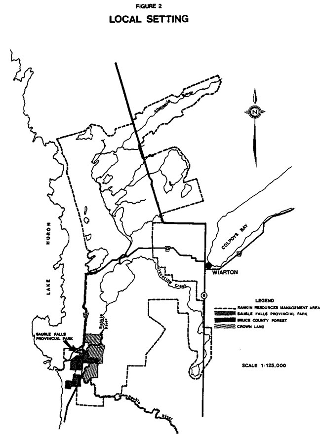
Sauble Falls Provincial Park was established in 1960 under Regulation 498 and is located 36 kilometres west of Owen Sound and approximately 2.5 kilometres north of Sauble Beach on County Road 21. The park is separated by County Road 21 (Figures 1 and 2). The total park area is 20 hectares with the west side at 14 hectares while the east side has approximately 6 hectares. The park derives its name from the picturesque limestone falls along part of its northern boundary.
The park is underlain by the Guelph Formation; a middle Silurian reefal complex composed of greyish to brown dolomite. The Sauble River crosses a resistant portion of the dolomite at County Road 21, resulting in the falls.
The dunes within Sauble Falls Provincial Park are located on part of a great sand plain that was deposited by glacial lakes Nipissing and Algonquin. These features are related to the dunes and large barrier bar that runs parallel to the Lake Huron coast. Also of interest is the ox-bow which represents an old course of the Sauble River.
The Sauble River is the major hydrological feature in the park. The Rankin River converges with the Sauble at the northeast park boundary.
Vegetation resources are typical of the Great Lakes - St. Lawrence forest. The result is a variety of vegetation communities dominated by sugar maple, white birch or white cedar.
Sauble Beach constitutes a major focus for recreationists and tourists and with Sauble Falls nearby, both features are within easy reach of the major cottage communities along the Lake Huron and Georgian Bay shoreline. The Rankin Resources Management Area to the north offers recreational activities such as hunting, fishing, hiking, canoeing, cross-country skiing, snowmobiling and bird and plant viewing.
Sauble Falls Provincial Park complements the natural amenities of the area and the local tourist economy by providing a variety of facilities. There are 152 campsites consisting of 130 tent-trailer sites and 22 pull-through. There are no electrical outlets. One group camping area with a capacity of 50 people presently exists. The day-use area south of the Sauble River has a parking capacity of 123 cars. The day-use area north of the Sauble River has a parking capacity of 36 cars.
1.1 Relationship to the Rankin Resources Management Area
The Rankin Resources Management Area immediately north of Sauble Falls Provincial Park, is an 80 square kilometre complex of lakes, rivers, wetlands, upland forests and agricultural lands. In addition to private landholdings, substantial tracts of land are owned by the Ministry of Natural Resources, the Sauble Valley Conservation Authority, the Bruce County Board of Education and the County of Bruce. The area is being managed to optimize the production and utilization of the resources and to attain the outdoor recreational targets for the Owen Sound District.
A strong link between Sauble Falls Provincial Park and the Rankin area will be established through cooperative efforts with agencies such as the Sauble Valley Conservation Authority and Bruce County. These efforts will include the management of the Rankin River canoe route, development of trails, a visitor services program and outdoor education facilities.
1.2 Relationship to Sauble Beach
Sauble Falls Provincial Park will compliment the private development at Sauble Beach through the provision of short term camping opportunities, access to Sauble Falls and the promotion of area attractions.
2.0 Park policies
Figure 1: Regional Setting
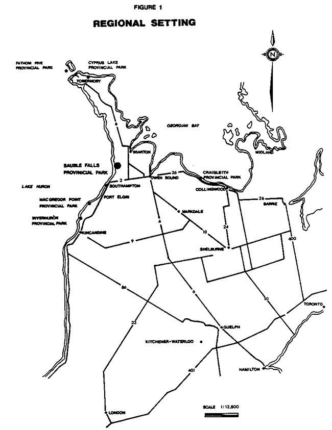
Figure 2: Local Setting
2.1 Classification
Sauble Falls Provincial Park is classified as a Recreation class park for its capability to provide a diversity of outdoor recreation activities for large numbers of people in attractive surroundings. Park visitors may participate in a variety of outdoor physical activities, in car camping, in group recreational and educational programmes and in natural and historical interpretation.
2.2 Goal
"To maintain and operate Sauble Falls Provincial Park so as to provide the highest possible quality and variety of outdoor recreational experiences for large numbers of people consistent with the capability of the natural and cultural landscape."
2.3 Objectives
Sauble Falls Provincial Park contributes to the objectives for recreation class parks by:
2.3.1 Recreation
"Providing day-use opportunities and facility-based camping opportunities in areas of outstanding recreation potential"
Sauble Falls Provincial Park is associated with two areas, Sauble Beach and the Rankin Resources Management Area, both of which possess outstanding recreational potentials. The park provides a variety of day-use and camping opportunities. Some of these opportunities will be available on a year round basis (for example, hiking, sport fishing and viewing the falls).
The walking trails in the park will integrate with the Rankin area to the north and the County and Crown lands to the south. The park’s camping facilities will act as a base for people wishing to visit nearby areas of interest.
The day-use and camping opportunities provided at Sauble Falls Provincial Park will contribute to achieving the recreational targets contained in the Owen Sound District Land Use Guidelines. A total of 114,788 camping opportunities and 104,474 day-use opportunities can be provided if the park were to be operated at its maximum potential. These figures represent 24% of the camping opportunities target and 40% of the day-use opportunities.
Management of these opportunities will recognize the park’s relationship to the community of Sauble Beach.
2.3.2 Heritage appreciation
"Providing opportunities for exploration and appreciation of natural and cultural environments through interpretation and education based upon the character and significance of Recreation Parks."
The significance of Sauble Falls Provincial Park relates to the Sauble River that flows through the park and to the park’s associations with the Rankin area and Sauble Beach. At Sauble Falls Provincial Park, interpretive and educational programs will reflect the natural features and cultural resources of the area.
2.3.3 Tourism
"Providing Ontario residents and out-of-province visitors with opportunities to discover and experience the distinctive regions of the Province".
Sauble Falls Provincial Park will provide day-use and camping opportunities for those tourists travelling through the area. The park will also serve as a destination for those tourists attracted to Sauble Beach from considerable distances who are seeking camping and recreation opportunities.
Recreational facilities and opportunities offered at Sauble will complement those offered elsewhere by the private sector in the area. Efforts will be directed towards promoting the variety of tourist facilities and recreation opportunities found throughout the Sauble area.
2.4 Boundary
The park boundary south and east of County Road 21 will over time be extended slightly southwards to encompass the group camping facility, the office and maintenance building. The buildings are owned by the County of Bruce and leased to the Ministry.
If the demand for camping opportunities in the area increases and the private sector is unable to meet this demand, then the Ministry will consider expansion of Sauble Falls Provincial Park. There is sufficient land in public ownership south of the park to provide up to 150 new campsites. Any expansion and development of new campsites will only be carried out after consulting with the local private campground operators and municipality. Planning for this expansion will be accomplished through a public review of the park management plan.
2.5 Zoning
One development zone to guide management encompasses the entire park including the small area proposed for expansion to the south. Medium to high intensity recreational opportunities, ranging from camping to day-use are provided. All support services and facilities such as comfort stations, picnic grounds, roads and maintenance and administrative buildings are provided. Site planning for all development minimizes any adverse environmental risks.
3.0 Resource management
The park’s natural and cultural resources will be managed in accordance with the general planning and management policies for recreation class parks. Specific direction, where needed to meet the requirements of Sauble Falls is provided below.
Although the policies are presented in separate categories, all planning and management will recognize that the com-ponents are inter-related and that an integrated approach will be required in order for the park to achieve its objectives.
3.1 Vegetation
Fires will be detected and suppressed through the use of standard methods.
Measures to control insects and disease will be permitted where aesthetic or natural values are threatened. Where control is desirable and feasible, it will be directed as narrowly as possible to the specific threat to minimize impact on other elements of the park environment. If required, control measures will be pre-scribed in a vegetation management plan.
A vegetation management plan will be prepared to provide guidance for monitoring and improving campsite rehabilitation measures and general landscaping. The major objective of the plan will be to define measures for maintaining the forest cover throughout the park.
3.2 Fisheries
Opportunities for excellent sport fishing and viewing the fish run are being provided and will be maintained.
3.3 Wildlife
A "no hunting" policy will be continued. However, the campground and facilities may be operated to accommodate sport hunters desiring and permitted to hunt on land outside the park (e.g. Rankin Resources Management Area). Regulations to permit possession of enclosed firearms by campers will be enacted.
Trapping to control nuisance animal popu- lations will be permitted under Ministry supervision.
4.0 Client services
4.1 Visitor services
The visitor services program will provide visitors with recreation opportunities related to understanding and appreciating the features in Sauble Falls and surrounding area. This will be achieved through the following components of a visitor services program.
4.1.1 Communications
Information concerning park resources, management, facilities, programs and nearby points of interest will be available at key points throughout the park (i.e. park office, main gates). Information will be provided through such means as a park leaflet, park staff, display and notice boards and the visitor centre.
4.1.2 Interpretation
The interpretive program will seek to create a greater understanding of the natural and cultural values of the park. Aspects of the program will consider the historical events of the past and present uses of the Sauble and Rankin river systems as well as adjacent lands. The interpretive program will be delivered through staff organized programs and self-use facilities such as trails and exhibits.
4.1.3 Outdoor recreation
A high quality, seasonal activity program related to the natural features and cultural resources of the park, the County and Crown land to the south and the Rankin Resources Management Area will be implemented. Particular emphasis will be placed on seasonally popular activities such as spring and fall fishing, fall hunting, canoeing, hiking and flora and fauna viewing.
4.1.4 Education
Sauble Falls will continue to be available to the Bruce County Board of Education for their outdoor education program.
4.1.5 Staff development
The park staff will continually strive to make a visitor’s stay as enjoyable as possible. This involves orientation and education of all park staff to relevant and current information about the park, the surrounding area and ways to enhance visitor satisfaction and understanding.
4.2 Research
Research within the park will be permitted so long as appropriate approvals are obtained. Topics requiring further research include the supply and demand of camping opportunities, suitability of present programs and the satisfaction of park visitors.
4.3 Marketing
A marketing plan will be prepared to attract more visitors during low-use periods in the mid-week and spring and fall seasons, to increase involvement with the commercial sector by encouraging park users to use and take advantage of local tourist services and attractions, and generally stimulate interaction between the park and the private tourist and commercial sector in the vicinity.
5.0 Development
Development will proceed in accordance with the following guidelines. Detailed site plans will be completed and approved in advance of rehabilitation of existing facilities or the development of new facilities.
5.1 Campgrounds
A development proposal for the east side campground is the provision of electricity to approximately 20 sites (Figure 3) to encourage visitors during the spring and fall seasons.
Campsite rehabilitation measures are being implemented and will be reviewed in five years to determine if they were successful.
5.2 Day use areas
The majority of day-use parking for fishermen and other recreationists occurs north of the Sauble River. This day-use area will continue to be provided at no charge as a contribution to the local tourist economy. Methods will be sought for maintaining this facility such as cooperative efforts with the municipality and volunteers.
Figure 3: Park Facilities and Proposed Development
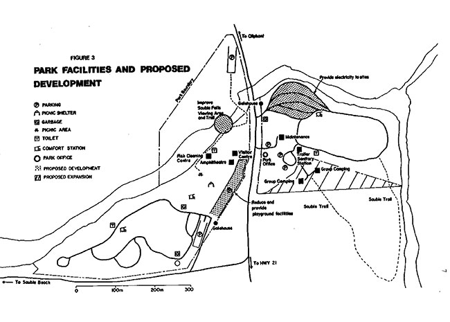
The day-use parking area south of the Sauble River and west of County Road 21 will be reduced in area and a variety of playground facilities developed.
5.2.1 Canoeing
Good canoeing opportunities exist along the Rankin and Sauble Rivers. A canoe launching facility will be provided in the north day-use area.
5.2.2 Viewing station
Viewing of fish spawning activity is a popular activity along the Sauble River and at Sauble Falls. This activity will be enhanced by the provision of seating facilities in landscaped surroundings on the south shore of the river.
6.0 Implementation
The following is a priority listing of projects which have been identified in the management plan.
- Prepare veqetation management plan to guide campsite rehabilitation measures
- provide electricity to approximately 20 sites
- extend boundary slightly southwards to encompass the group camping area and administration area
- construct canoe launching facility and restructure day-use area
- upgrade viewing opportunities
- enact regulation to permit possession of encased firearms
- prepare marketing plan to promote the variety of tourist facilities and recreation opportunities in the Sauble area
- Integrate walking trails with the Rankin area
- monitor demand prior to the development of new campsites
The management plan will be reviewed in 10 years following its approval, or earlier if the need arises. As funds and priorities permit, additional research will be conducted on natural and cultural values, and recreational user demands provide a basis for future reviews of the plan.
7.0 Public consultation
The following steps were taken to incorporate public consultation in the preparation of the Sauble Falls Provincial Management Plan.
A mailing list was prepared consisting of local residents, interest groups, municipalities, government agencies and members of both the federal and provincial parliaments. Twenty-eight copies of the draft management plan were mailed out on November 30, 1984, with four responses being received by the January 18, 1985 deadline for public comment.
A letter was sent to 500 park visitors asking them if they were interested in reviewing the draft plan. Sixty-four people took the time to either write or telephone requesting a copy of the draft management plan. Out of the 64 requests, 29 people returned written comments by the January 18, 1985 deadline.
A news release was mailed out on November 30, 1984, and a newspaper advertisement was placed in the local newspapers during the first week of December, 1984. These efforts were designed to inform people of the preparation of the management plan and that copies of the draft plan were available at the Owen Sound District Office.
The results of the various communication efforts were 33 separate letter raising 46 issues. A report was then prepared summarizing the analysis of the public comment. On copy of the summary was sent to the each person that had submitted comments.
Based upon Ministry of Natural Resources staff discussions and external input, the final plan was prepared, approved and copies sent to the municipalities, members of parliament and other interested parties.