Schreiber Channel Provincial Park Management Plan
This document provides policy direction for the protection, development and management of Schreiber Channel Provincial Park and its resources.
Note: This document has been scanned and formatted, and therefore is slightly different from the original version. -March 2002
Additional copies of this publication are obtainable only from:
Terrace Bay District Office
P.O. Box 280
Terrace Bay, Ontario
P0T 2W0
Telephone: (807) 825-3205
© 1985 Government of Ontario
Approval statement
Schreiber Channel Provincial Nature Reserve contains outcrops of bedrock in which are preserved the fossilized remains of some of the oldest forms of life known in Canada.
We are pleased to approve the Schreiber Channel Provincial Nature Reserve Management Plan as official policy for the management and development of this park. The plan reflects this Ministry’s intent to protect the natural features of Schreiber Channel Provincial Nature Reserve, while providing research opportunities to the scientific community and educational opportunities to the general public.
Signed by:
G.P. Elliott
Regional Director
North Central Region
Date: April 15, 1985
Signed by:
N.R. Richards
Director
Parks and Recreational Areas Branch
Date: April 2, 1985
1.0 Introduction
1.1 Location
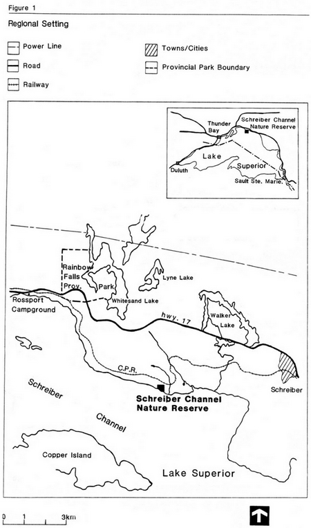
Schreiber Channel Provincial Nature Reserve is located in Killraine Township on the north shore of Lake Superior, 6 km (3.7 mi.) west–southwest of Schreiber, Ontario (Figure 1).
1.2 Legal status
Schreiber Channel Provincial Nature Reserve was established in 1979 and is described in the Revised Regulations of Ontario, 1980 (Ontario Regulation 821/80, Appendix B, Schedule 123).
1.3 Physical setting
Schreiber Channel Provincial Nature Reserve incorporates internationally recognized occurrences of cherty rocks notable for the remains of microscopic life forms they contain. The Lower Algal Chert submember of the Gunflint Formation, of Middle Precambrian age, contain evidence of some of the oldest known life forms in the world. The park also incorporates a provincially significant exposure of the lowest member of the Gunflint Formation, the Kakabeka Conglomerate, and an example of the approximately 500 million year erosional interval between the Early and Middle Precambrian in the form of the unconformable metavolcanic–sedimentary contact.
2.0 Park policies
2.1 Goal
The goal of the provincial parks system is to provide a variety of outdoor recreation opportunities and to protect provincially significant natural, cultural and recreational environments in a system of provincial parks. The protection component of this goal is recognized in all six classes of provincial parks, but it is fundamental to the nature reserve classification (Ontario Ministry of Natural Resources, 1978a).
The goal of Schreiber Channel Provincial Nature Reserve is to protect the rocks of the Gunflint Formation and their microfossil assemblages in a natural and integral state, while providing on– site opportunities for controlled research and interpretation to the geoscience community and educational groups.
2.2 Objectives
Of the four objectives of the provincial parks system: protection, recreation, heritage appreciation, and tourism, Schreiber Channel Provincial Nature Reserve will contribute towards achievement of the protection and heritage appreciation objectives.
2.2.1 Protection objective
"To protect provincially significant elements of the natural and cultural heritage of Ontario." Schreiber Channel Provincial Nature Reserve encompasses an internationally recognized assemblage of microscopic Precambrian fossil remains of significant age, biological diversity and excellence of preservation. The park contributes to the protection objective by incorporating the principal microfossil locations in situ (in place).
Figure 1: Regional Setting
Enlarge Figure 1: Regional Setting
2.2.2 Heritage appreciation objective
"To provide opportunities for the exploration and appreciation of the outdoor natural and cultural heritage of Ontario. Schreiber Channel Provincial Nature Reserve will continue to provide an important research base to those scientists involved in the study of Precambrian life forms and conditions. Although public access to the park will be limited, the features for which the park was established will be interpreted "at arm’s length" in the interpretive programs of other, more accessible parks.
2.3 Classification
The nature reserve classification is designed to identify those unique and representative biophysical features in Ontario worthy of protection for their natural values. Parks classified as nature reserves are designated where representation of significant earth and life science features does not occur in the other classes of parks and where the incorporation of isolated or specialized environments is necessary.
Schreiber Channel Provincial Nature Reserve is classified as a provincial nature reserve under the Provincial Parks Policy of 1978. As such, it will be managed in a manner guided by the Ontario Provincial Parks Planning and Management Policies (O.M.N.R.,1978a). The site was initially set aside in 1975 in recognition of the internationally renowned microbial fossil assemblage preserved in the rocks of the Gunflint Formation, and in response to a perceived increase in sampling pressures on the site as it becomes more widely recognized. The significance of the rocks at the Schreiber Channel locality has been known to the geoscience community since 1953. Establishment of the park in 1979 has provided the site with protected status under the Provincial Parks Act.
2.4 Boundary description
The boundaries of the park are described in the Revised Regulations of Ontario. The mainland area of 12.173 ha (30.079 acres) is defined by a rectilinear boundary based on a parcel of land originally withdrawn under the Mining Act (Order No. W.13/75; Section 43; R.S.O. 1970). Flint Island (formerly Island J.D. 2100) is also included in the nature reserve, covering 0.736 ha (1.819 acres). The total land area of the nature reserve is 12.909 ha (31.898 acres).
The boundaries of the park have not been surveyed. There is some question whether the surveyed location of the park will adequately incorporate the principal microfossil sites, particularly in the western portion of the park. As an interim step, an area adjacent to and west of the park has been removed from claim staking in order that it can be incorporated into the park if indicated by a ground survey.
2.5 Zoning
Schreiber Channel Provincial Nature Reserve will be zoned entirely as a nature reserve consistent with the guidelines contained in the Ontario Provincial Parks Planning and Management Policies (O.M.N.R.,1978a). The difficult access and isolation of the nature reserve preclude any need for an access zone.
3.0 Resource management
Resource management policies and controls will emphasize steps necessary to provide protection to the geological features located in the park. The overall approach will be one which emphasizes the maintenance of the integrity and quality of the microfossil-bearing outcrops, and the retention of the nature reserve area in as natural a state as possible.
Guidelines for management activities in nature reserves are outlined in the Ontario Provincial Parks Planning and Management Policies (O.M.N.R.,1978a). These guidelines generally discourage management prescriptions which would unnecessarily alter the natural integrity of the site unless particular resource values are threatened. Development and use which is relatively low-key is promoted. In keeping with this intent, this section describes the management prescriptions which apply at Schreiber Channel Provincial Nature Reserve.
Commercial resource extraction for timber, minerals or aggregate will not be permitted. The suppression of wildfires and control of insects/disease will take place as required to protect commercial/private interests identified outside the nature reserve. Maintenance of the trail operated by the Voyageur Trail Association along the designated route through the park will be undertaken as required to ensure hiker safety. Campsites will not be developed and overnight stays in the nature reserve will be discouraged.
Hunting and trapping will be permitted activities in the park since they do not directly affect the integrity of the geological features for which the nature reserve was established. These activities will have minimal conflict with research/educational activities due to the seasonal variation in the use of the site by the respective user groups. Management of the geological features in the park will be limited to the adherence to established policies as they relate to research and the enforcement of Provincial Parks Act regulations pertinent to the unauthorized removal of materials from within the nature reserve.
4.0 Client services management
4.1 Visitor services
The visitor services program for Schreiber Channel Provincial Nature Reserve will emphasize the distribution of pertinent information concerning the site, interpretation of the geological features, and the opportunities for research and outdoor education.
The major objective of the park is to protect the outcrops of algal chert. As such, use of the nature reserve by scientists, researchers, school groups, teachers, and others for research and outdoor education will be encouraged but not solicited. Information pertaining to the nature reserve will be distributed to the public through the interpretive program at Neys Provincial Park, because of its proximity to the nature reserve, and from the Ontario Ministry of Natural Resources district office in Terrace Bay.
A low key interpretive program at Neys Provincial Park will emphasize the following points:
- the philosophy and objectives of the nature reserve class of park
- the management and operating policies as they relate to provincial nature reserves
- the environmental conditions during the Precambrian which brought about the life forms and their remains in the park, and the significance, extent, and type of life forms which are represented in the rocks of the park
- how these life forms are represented in outcrop in Schreiber Channel Provincial Nature Reserve
- the need to preserve the few remaining outcrops of algal chert in their natural state
The features found at Schreiber Channel Provincial Nature Reserve may be linked to those found in the nature reserve zone protecting similar features in Kakabeka Falls Provincial Park (Ontario Ministry of Natural Resources, 1978b). The occurrence of the algal chert at Kakabeka Falls will be emphasized in the interpretive program at Neys Provincial Park as a site where the unit can be observed easily and with a minimum of disturbance.
4.2 Research
Scientific research is expected to be the major on–site activity in the park. All research by individuals or groups will abide by the policy governing research activities in provincial parks. In addition, the following provisions will also apply to research activities at Schreiber Channel Provincial Nature Reserve:
- when practical, staff from the Ontario Ministry of Natural Resources will accompany on–site visitations made by researchers and educational groups to the site in order to record and monitor the impact on the site
- acknowledgement of government approval and the application procedures required for research in provincial parks will be given in any published research results
- research proposals by Ontario Government personnel are subject to the above conditions
- the Ontario Ministry of Natural Resources will co–ordinate the formation of an advisory group for purposes of reviewing research proposals
The Schreiber Channel locality is acknowledged by most researchers in the field to be the premier locality of the known such sites for studying the Gunf lint microbiota. As such, other sites of algal chert from the Gunflint Formation hold little promise of diverting sampling pressure from the park.
Where feasible, future research proposals which require samples of known orientation/location may be directed to existing sample suites of the Gunflint microbiota, both private and public, in order to relieve in situ sampling in the park. A list of past researchers and the location and extent of their sample collections will be compiled for this purpose. Similarly, the Ontario Ministry of Natural Resources is attempting to locate a sample suite of suitable rocks with a public institution in an attempt to provide another alternative to in situ sampling. Where samples of unspecified orientation and/or locality are adequate, the collection of suitable loose material from the shoreline of the park will be encouraged in preference to in situ collecting. This is expected to be the major source of material collected for research purposes at the site.
Detailed photographic coverage and mapping of the principal microfossil sites will prove beneficial to the future monitoring of these sites. Knowledgeable staff from the Ontario Geological Survey or an outside researcher will be requested to produce such a "control map" at some future date.
5.0 Development
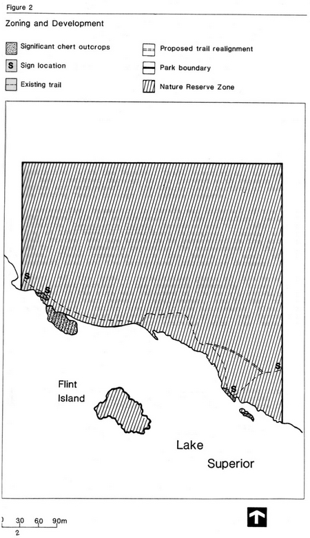
In keeping with the low–profile approach to park development, no facilities of any kind will be provided. The Voyageur Trail Association, in co–operation with the Ontario Ministry of Natural Resources, will maintain the existing hiking trail through the park. Approval for alterations in the signage or routing of the trail will be required from the Ontario Ministry of Natural Resources. In order to minimize trail user impact on the eastern outcrop of algal chert in the park, that portion of the trail which presently crosses the outcrop will be relocated inland (Figure 2).
The only other development in the nature reserve will involve signage. Signs will be located in four places (Figure 2): one at each end of the hiking trail where it enters the nature reserve, and one at each of the two main microfossil sites. It is recommended that the two nearshore signs be placed flat against the rock outcrop at locations that are readily visible from the pertinent sites but which are invisible from the lake in order to avoid undue attraction to passing boaters.
The signs placed in the nature reserve will not indicate the specifics of the features being protected. Each sign will present the name of the nature reserve, the fact that the natural features are legally protected, and a phone number and address (Terrace Bay district office) where more information can be obtained.
6.0 Implementation strategy
The following steps will be taken in order to implement the management policies outlined above:
- The boundary of the park will be surveyed and marked. This is necessary to ensure the adequate protection of the principal microfossil sites and to identify the park to adjacent land uses
- The recommended signage will be erected
- The Voyageur Trail Association, in conjunction with the Ontario Ministry of Natural Resources, will be asked to reroute the portion of the hiking trail which presently transects the eastern algal chert outcrop
- The text and displays for the recommended input to the Neys Provincial Park interpretive program will be produced
- Steps will be taken to implement a sample collection at a public institution to which the scientific community can be directed for their sampling needs
- The sample collections of past researchers will be documented and the list made available to researchers proposing to sample in the park in future
- Detailed photographic coverage of the pertinent outcrops will be undertaken and a "control map" at a suitable scale will be produced
- An advisory group will be formed for the review of research proposals. Terms of reference will be developed for this group
Figure 2: Zoning and Development
Enlarge Figure 2: Zoning and Development
7.0 Public consultation
Consultation with the Voyageur Trail Association, initiated in 1979, has continued through to the present with regards to the location and management of the Casque–Isle Section of the North Shore Hiking Trail through the nature reserve.
The scientific community in Canada was informed of the park’s establishment via an announcement in the Canadian geological publication Geoscience Canada (Davidson and Kor, 1980). In the spring of 1982 several researchers throughout Canada and the United States who are known to be interested in the site were asked for their comments regarding the management of the nature reserve. These comments form the basis of much of this management plan and the background information document.
As part of the public consultation phase of this Management Plan, a larger portion of the research community known to be interested in the site was informed of the park’s establishment and the resultant research requirements, and further comments were solicited. Public reaction to the Management Plan, both locally and amongst selected interest groups, was favourable, with no indication of major concerns with the management policies outlined.
References
Davidson, R.J. and P.S.G. Kor, 1980. Protecting Ontario’s Ancient Fossil Record: Schreiber Channel Provincial Nature Reserve and Kakabeka Falls Provincial Park. Geoscience Canada, v.7, no.3, p.118–120.
Ontario Ministry of Natural Resources, 1978a. Ontario Provincial Parks Planning and Management Policies.
Ontario Ministry of Natural Resources, 1978b. Kakabeka Falls Provincial Park Master Plan, 111p.