Selkirk Provincial Park Management Plan
This document provides policy direction for the protection, development and management of Selkirk Provincial Park and its resources.
Note: This document has been scanned and formatted, and therefore is slightly different from the original version. -March 2002
Additional copies of this publication are obtainable only from:
Ministry of Natural Resources
P.O. Box 706
Highway 3
548 Queensway West
Simcoe, Ontario
N3Y 4T2
Telephone: (519) 426-7650
Approval statement
We are pleased to approve the Selkirk Provincial Park Management Plan as official policy for the management and development of this park. The plan reflects this Ministry’s intent to protect natural features of Selkirk Provincial Park and maintain high quality opportunities for outdoor recreation and heritage appreciation for both residents of Ontario and visitors to the Province.
Signed by:
David J. Johnstone
Regional Director
Southwestern Region
Signed by:
N.R. Richards
Director,
Parks and Recreational Areas Branch
1.0 Introduction
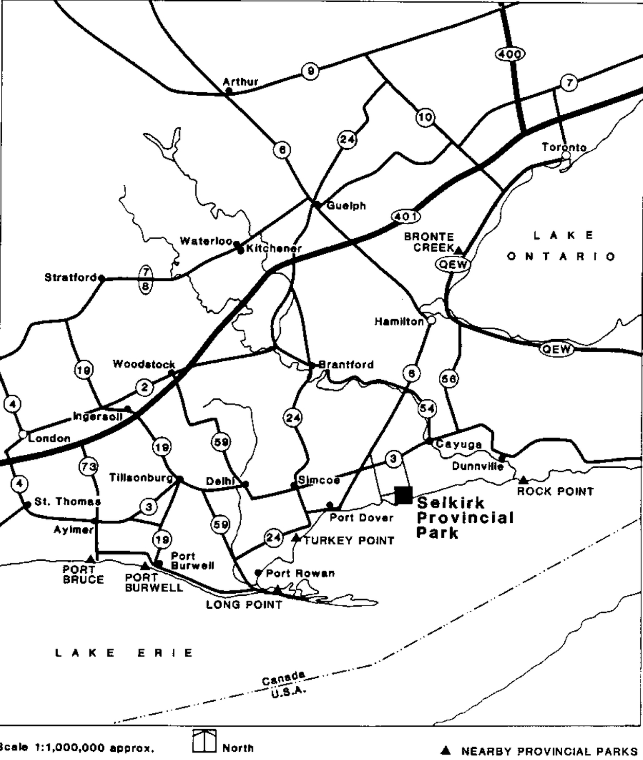
Selkirk Provincial Park is located on the shoreline of Lake Erie near the community of Selkirk (Figure 1). It lies within an hour’s drive of the Hamilton - St. Catharines - Niagara Falls portion of the "Golden Horseshoe" and a population of three-quarters of a million people. Established by Regulation 821 under the Provincial Parks Act with an area of 73 hectares, the park provides camping, picnicking facilities and access to Lake Erie for swimming, fishing and boating. There are 145 campsites, 44 of which have electrical hook-ups, and 200 day use parking spaces (Figure 2). A 2 km nature trail meanders through woods and meadows, and along and across the marshy portion of Spring Creek at the western end of the park.
Selkirk Provincial Park commenced operation as a Provincial Park in 1969, primarily to provide recreational opportunities for the anticipated influx of people into the Haldimand-Norfolk Region. However, the increase in local population has not materialized as employment opportunities at the Nanticoke Industrial Complex failed to reach forecasted levels.
2.0 Classification
Selkirk Provincial Park is classed as a Recreation Park, which is a category of park that supports a wide variety of outdoor recreation opportunities for large numbers of people in attractive surroundings. Selkirk Provincial Park provides recreational opportunities for campers, picnickers and swimmers.
3.0 Goal
To provide outdoor recreation opportunities and access to Lake Erie compatible with the heritage and natural values of the park.
4.0 Objectives
Selkirk Provincial Park contributes towards meeting the objectives of the provincial park system.
4.1 Protection
To protect provincially significant elements of the natural and cultural landscape of Ontario.
Regionally significant features of the park include a freshwater marsh and a relatively pure stand of Shagbark Hickory trees. A Natural Environmental Zone will be designated to protect these features.
4.2 Heritage appreciation
To provide opportunities for exploration and appreciation of the outdoor natural and cultural heritage of Ontario.
Within Selkirk Provincial Park are several sites of archaeological interest (Indian campsites) dating from 5,000 to 300 years B.C. More recently, the land base of the park has been used for logging black walnut (the Hoover family in the late 1700's), for farming (William Francis in the early 1800's), and for operating a commercial fishing enterprise (Walter Wheeler, 1923 - late 1940's). Opportunities will be provided within the park to make visitors more aware of the historic features identified.
Figure 1: Regional Setting
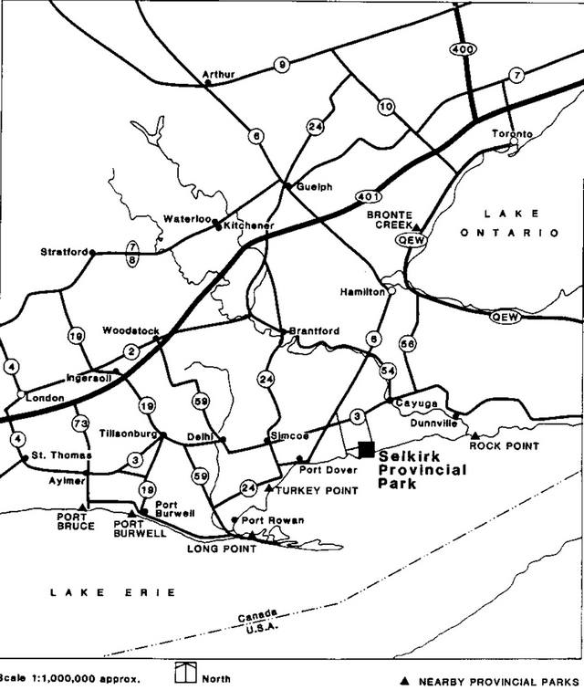
Enlarge Figure 1: Regional Setting
Figure 2: Existing Development
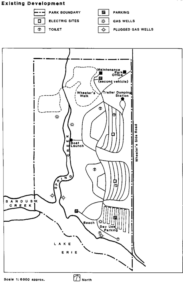
Enlarge Figure 2: Existing Development
4.3 Recreation
To provide provincial park outdoor recreation opportunities ranging from high intensity day use to low intensity wilderness experiences.
Selkirk Provincial Park will provide day-use and camping opportunities in a lakeside setting and provide access to Lake Erie for Swimming and other water-related recreation. Present user statistics reveal that this park is underutilized; only 26% of the available campsites were occupied in July and August of 1986. Thus, additional campsite development is not required. This should be revaluated if future marketing initiatives positively influence park use.
4.4 Tourism
To provide Ontario’s residents and out-of-province visitors with opportunities to discover and experience the distinctive regions of the province.
As noted above, campsite occupancy is lower than is desirable. Therefore, a strategy will be prepared to market the park more effectively. Items of possible interest in the nearby communities will be promoted along with features of the park.
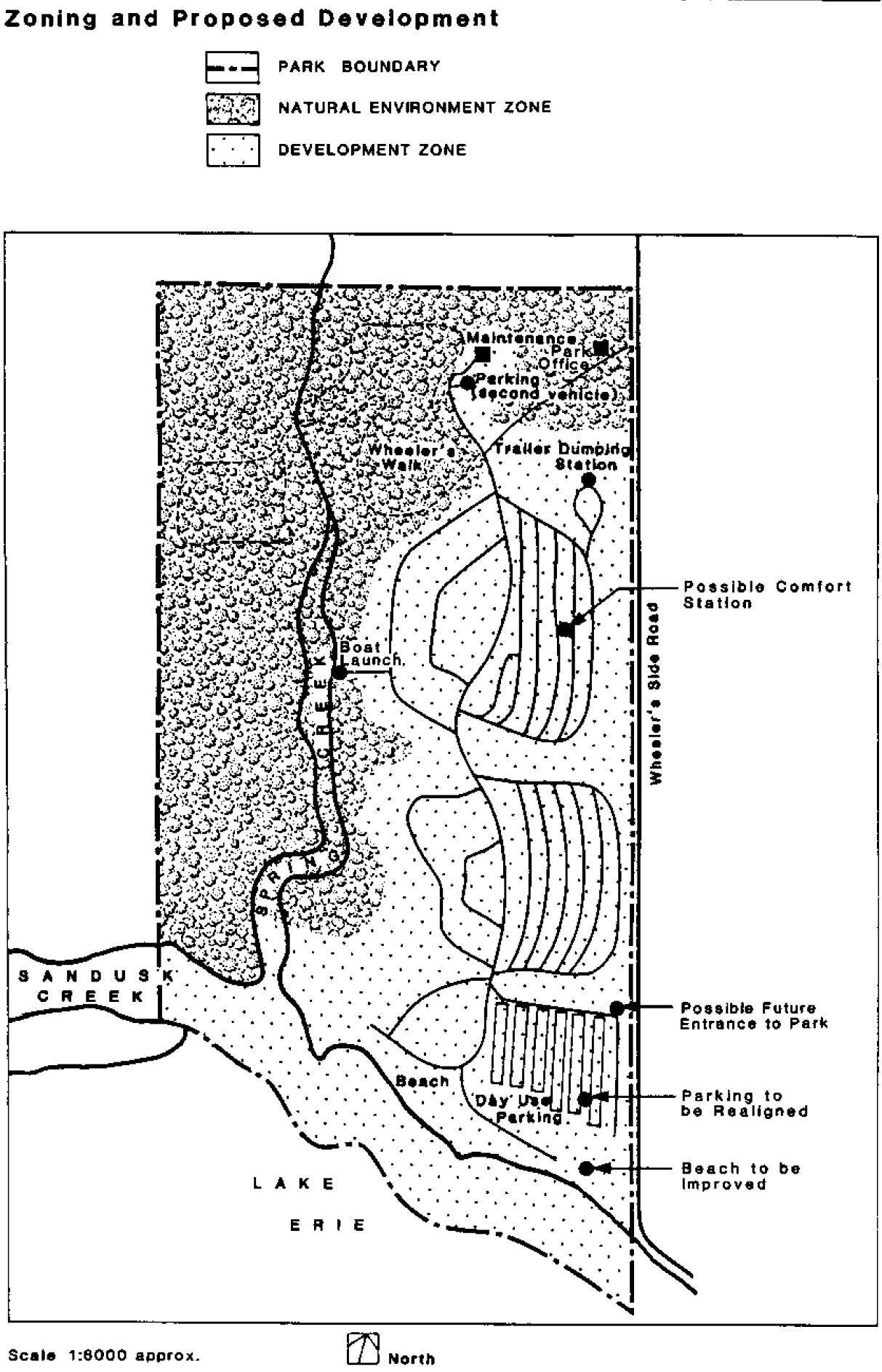
5.0 Park boundaries and zones
The boundary of Selkirk Provincial Park is described in Figure 3. Within the park are two zones which reflect the potential and the limitation of the landscape to accommodate particular types of development and activity.
5.1 Development zone
The eastern portion (41 hectares) of the park meets the needs of campers, picnickers and swimmers, and will accommodate the minor alterations to existing facilities proposed in Section 8.
5.2 Natural environment zone
The western portion (32 hectares) of the park will be zoned to limit development and to protect the natural features of the area. A hiking trail and simple interpretative facilities, to support such activities as nature photography and wildlife viewing, will be the only types of development permitted in this zone.
6.0 Resource management
6.1 Landforms
During the recent period of high water on Lake Erie, there has been significant erosion of the park’s shore. This has caused damage to park facilities and adversely affected recreational use of the beach. To make the beach more accessible, the steep, eroded bank will be regraded and revegetated once water levels drop and erosion slows. No structural erosion protection will be installed, but vegetation may be planted to slow erosion where feasible.
6.2 Vegetation
Selkirk Provincial Park, prior to acquisition for park purposes, was primarily farmland used for pasturing cattle and growing hay. Much of the management effort will be directed to providing a more diverse and visually pleasing landscape by planting, throughout the park, a variety of trees and shrubs. Species native to the Carolinian Zone will be used for planting purposes.
Figure 3: Zoning and Proposed Development
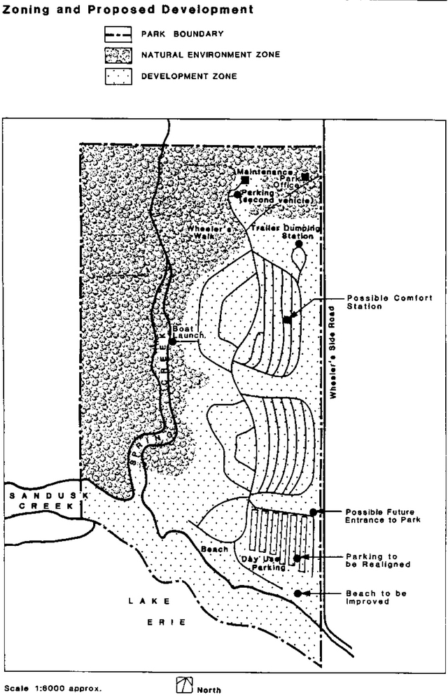
Enlarge Figure 3: Zoning and Proposed Development
The existing stand of mature Oak-Shagbark Hickory will be managed to assure the perpetuation of this community. However, trees that pose a threat to park visitors or property will be removed as required.
Trees and shrubs will be planted along the eastern boundary of the park to create a visual and sound barrier to minimize the impact of vehicles travelling along the adjacent township road.
Wildfires will be suppressed, and grass mowing will be restricted to the areas of intense use within the development zone.
A Vegetation Management Strategy will be prepared to define the management prescriptions necessary to implement the above directions.
6.3 Wildlife
The lack of species diversity in the plant communities within Selkirk Provincial Park severely restricts the numbers and varieties of wildlife found there. Planting of trees and shrubs to improve the aesthetics of the park will also create conditions that favour a more diverse wildlife community. Habitat management for wildlife purposes will therefore be part of the Vegetation Management Strategy.
Hunting within the park is not permitted. Hunter access to Lake Erie will be permitted during the waterfowl season. Selkirk Provincial Park extends 300 feet into Lake Erie. Nuisance animals will be removed or destroyed under the direction of the Ministry.
6.4 Cultural resources
A number of aboriginal archaeological sites have been identified within the park. No development will be undertaken that will disturb or make the sites inaccessible for further research. Use will be limited to activities such as picnicking and nature viewing. The public will be made aware of the areas' past through the interpretive program.
6.5 Petroleum
Several abandoned natural gas wells are located within the boundaries of Selkirk Provincial Park, and use of natural gas will be evaluated as a possible energy source for park purposes.
7.0 Operations policies
A park operations strategy will be prepared to guide the day-to-day operation of the park. Park operations will be consistent with the Ontario Provincial Parks Operating Standards. The operations strategy will be reviewed annually and updated as required.
7.1 Visitor services
7.1.1 Information
Park visitors will be provided with information relating to the park, local attractions, and other Ministry of Natural Resources programs. This information will be available in the park office in the form of brochures and displays. Park and local events will be posted on bulletin boards located at washrooms and at the park office.
7.1.2 Interpretation
The main interpretive theme will be plant succession within the park’s various plant communities. A secondary theme will be the parks history, including aboriginal uses, farming, logging, and commercial fishing. The interpretive program will be self-serve and will consist of brochures and an interpretive trail.
7.1.3 Recreation
No recreational programs will be provided by staff, but sports equipment will be available for use by park visitors.
7.2 Research
Research into shoreline processes and the ecology of the park’s Carolinian vegetation will be encouraged. Other research may be allowed if compatible with park objectives. All research will be conducted in accordance with Provincial Parks policies.
7.3 Marketing
Because the park’s July - August campsite occupancy rate is low, there is an opportunity to increase park camping use significantly. User surveys have shown that the park’s campers tend to be older and stay longer than is typical of provincial parks, and that most visitors reside in the Niagara - Hamilton - Toronto metropolitan area. Local use of the park is limited due to the unexpectedly slow growth of the Haldimand - Norfolk Region’s population.
A marketing strategy will be developed to encourage increased use of the park. It will concentrate on the best potential market for the park, the Hamilton - Niagara area, and will make a wider range of potential visitors aware of the park and its assets. Based on user surveys, the beach and sanitary facilities will be improved, showers added, and more campsite electrical hook-ups provided. These changes will complement the marketing strategy by making the park a more desirable destination for campers and others.
8.0 Development
Development in Selkirk Provincial Park will be undertaken to improve the quality of the outdoor recreation opportunities available and thereby increase the use of the park. Development will be undertaken in phases as funding allows. Detailed site plans will be designed for individual projects to ensure that development is compatible with the environmental setting.
8.1 Administration and operations
The park entrance will remain at its present location. If use of the beach and picnic area increases significantly, then consideration will be given to relocating the park entrance to the south end of the park, so that day use area visitors do not have to drive through the campground and disturb campers.
Main park roads will be paved with a tar and chip surface to reduce maintenance costs and provide a smoother driving surface.
8.2 Day-use area
The parking lots within the day-use area of the park will be re-designed and upgraded. Upgrading will improve traffic flow, increase parking capacity, and accommodate campground users' second vehicles.
8.3 Campground
Selkirk Provincial Park has 145 developed campsites, of which 44 have electrical service. Campers frequently comment on the need for additional sites with electrical services along with a more modern comfort station and showers. Electrical services will be upgraded and expanded. A comfort station with showers will be constructed in order to bring campground facilities up to accepted provincial park standards.
A self-guiding display area will be provided within the entrance control building. Displays and printed information pertaining to the park and the surrounding area will be featured.
A self-guiding trail system, based on the existing one, will be developed in the natural environment zone to provide information about the natural features of the park.
8.5 Boat dockage
A nearby marina provides launching facilities for large boats. Within the park there will be a facility for placing small (car top) boats in Spring Creek, but no provision will be made for launching larger boats.
9.0 Implementation
Development within Selkirk Provincial Park will follow the management plan subject to availability of development funds.
The management plan will be reviewed not less than every 10 years, but may be reviewed sooner if the need arises.
Proposed Order of Implementation:
- Construct shower building
- Conduct technical evaluation of existing gas wells to determine potential for use
- Prepare and implement marketing strategy
- Prepare and implement a vegetation management strategy
- Implement beach improvement
- Improve and maintain trail system
- Pave main roads with tar and chip surface
- Upgrade the day-use parking area
- Upgrade electrical service within campground
10.0 Summary of public consultation
Planning for Selkirk Provincial Park began in 1981, when a preliminary master plan was produced. The preliminary plan was made available for public review. Public response was limited, and the content of this management plan is similar to that of the preliminary document.
Selected references
Harland, R. 1979. Selkirk Provincial Park Life Science Inventory (edited by J. Rhodes). Ontario Ministry of Natural Resources (O.M.N.R.) unpublished technical report, Simcoe District, Simcoe.
Klinkenberg, R. and J. Rhodes, 1981. Preliminary Vegetation Study - Selkirk Provincial Park, June 4, 1981 O.M.N.R. unpublished technical report Southwestern Region, London.
O.M.N.R. 1972. Selkirk Provincial Park - Background Information to O.M.N.R. Simcoe District, Simcoe.
O.M.N.R. 1973-84. Ontario Provincial Parks Statistics. Queen’s Park, Toronto.
O.M.N.R. 1976. Selkirk Provincial Park: Interim Management Guideline. Simcoe District, Simcoe.
O.M.N.R. 1978. Park Management I Operating Plan - Selkirk Provincial Park, Simcoe District, Simcoe.
O.M.N.R. 1978. Ontario Provincial Parks Planning and Management Policies. Queen’s Park, Toronto.
O.M.N.R. 1978. Provincial Park Day User and Camper Surveys. Queen’s Park, Toronto.
O.M.N.R. 1981. Preliminary Master Plan, Selkirk Provincial Park, draft report. Simcoe District, Simcoe. 19 pp.
O.M.N.R. 1983. Simcoe District Land Use Guidelines. Simcoe District, Simcoe. 57 p.