Sharbot Lake Provincial Park Management Plan
This document provides policy direction for the protection, development and management of Sharbot Lake Provincial Park and its resources.
© 1988, Queen’s Printer for Ontario
Limited copies of this management plan are available from:
Ministry of Natural Resources
Carleton Place District Office
10 Findlay Avenue
Carleton Place, Ontario
K7C 3Z6
3377
100 P.R. 8812 20
ISBN 0-7729-0512-6
Approval statement
November 1988
We are pleased to approve the Sharbot Lake Provincial Park Management Plan as official policy for the management and development of this park. The plan reflects the ministry’s intent to protect the natural and cultural features of Sharbot Lake and to maintain high quality opportunities for outdoor recreation and heritage appreciation for residents of Ontario and visitors to the province.
Signed by:
J. R. Oatway
Regional Director
Eastern Region
Signed by:
Norm R. Richards
Director, Parks and
Recreational Areas Branch
Introduction
Sharbot Lake Provincial Park, established in 1958, covers 68.85 hectares (ha) of picturesque Canadian Shield country in the Township of Olden in the County of Frontenac. The park fronts Black Lake and Sharbot Lake. These lakes provide a variety of experiences and challenges for the park user. Black Lake is small, quiet and sheltered while Sharbot Lake is large, deep and windy. Views to both Sharbot and Black lakes are afforded by the high ridge between them. The ridge area contains life and earth science features of local significance.
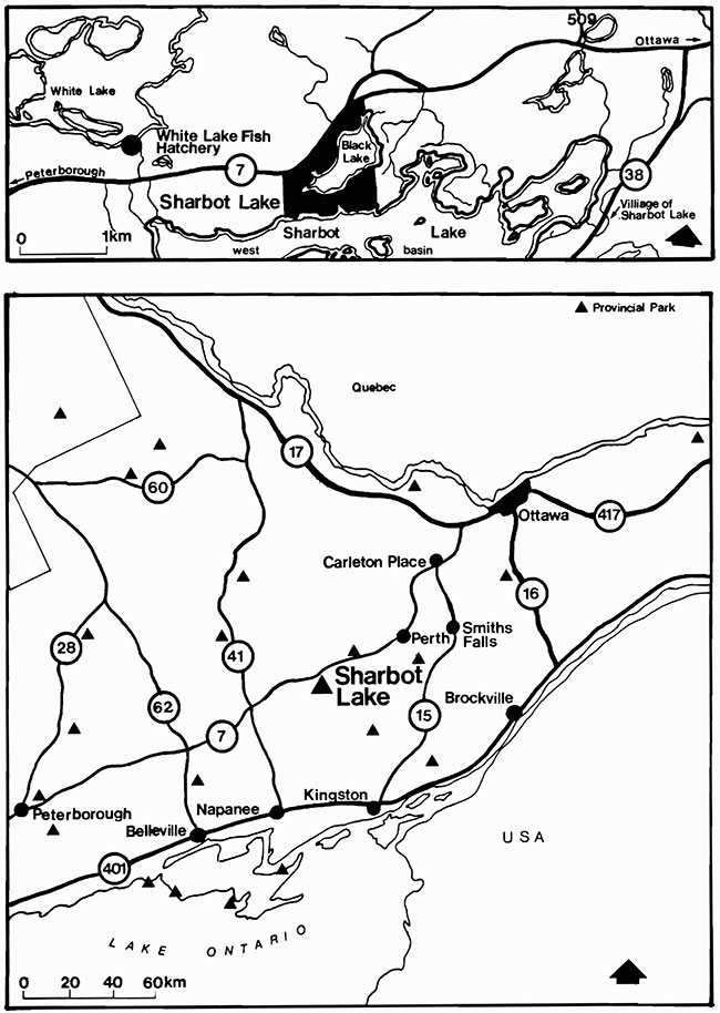
The closest community is the Village of Sharbot Lake on Highway 38. See figure 1. The park is within a two hour drive of Ottawa, Peterborough and Kingston. 21
The park offers opportunity to enjoy recreational activities on land or water and to relax in a quiet natural setting.
Camping is the foremost activity enjoyed at the park. There are four campgrounds with 185 sites providing camping for tents, trailers and motor homes. Thirty campsites are equipped with electrical outlets.21
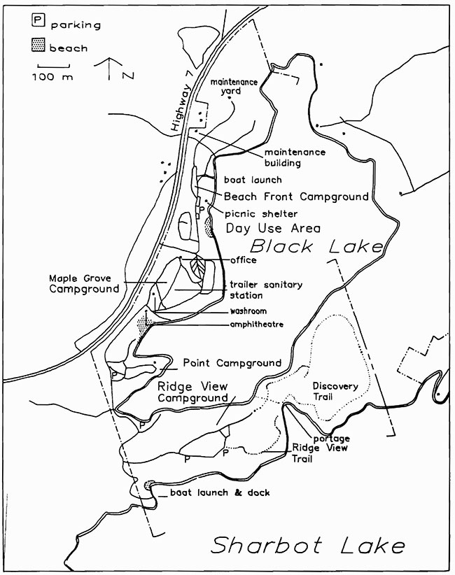
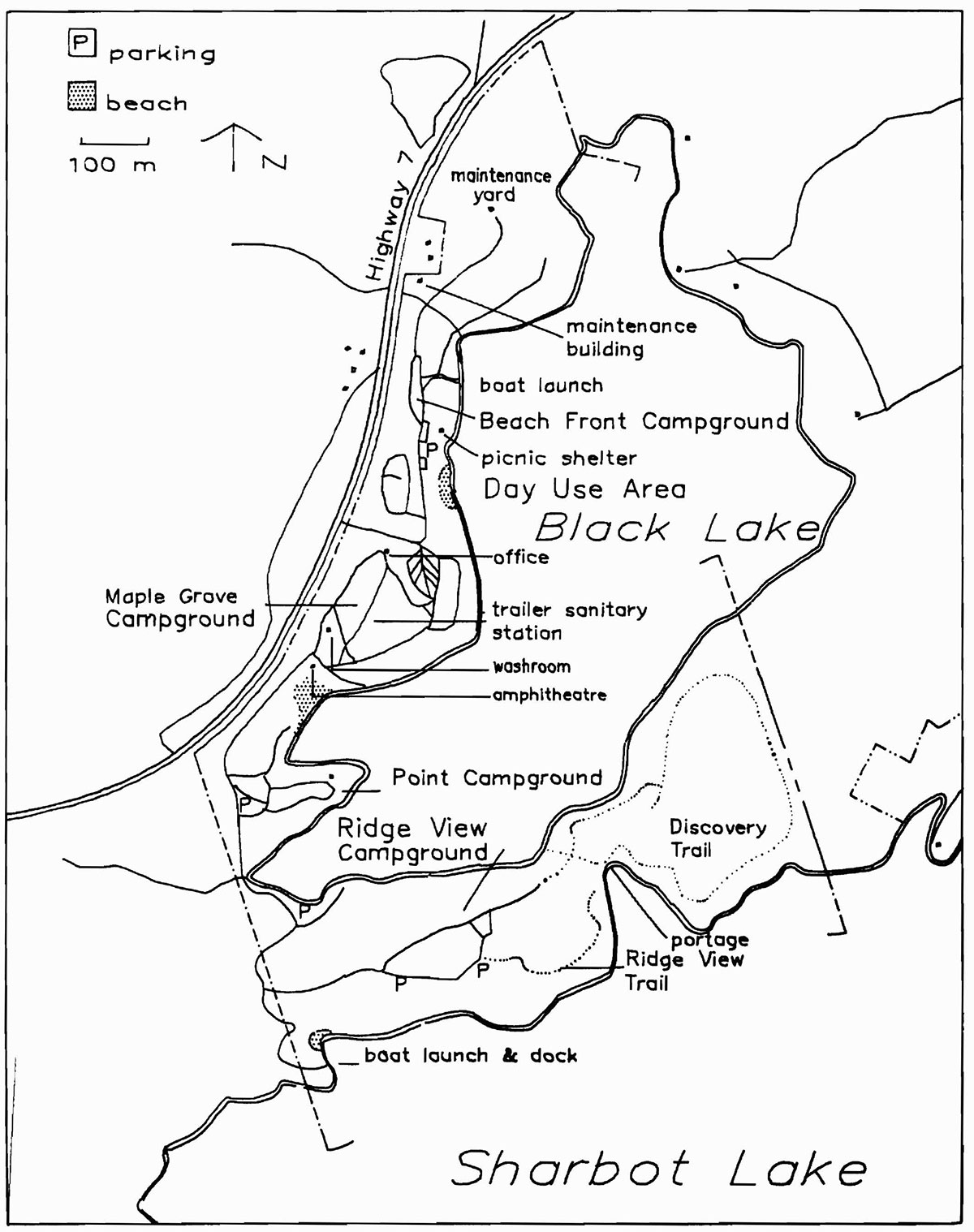
Facilities provided for the public, shown in figure 2, include: a comfort station with laundry and showers, vault privies, beaches with change houses, a small day use area with play structures, a picnic shelter, a woodlot, an amphitheatre, docks, a trailer sanitary station, boat launches and an office/gate house?21
There are no facilities for group camping due to a lack of available space. 21
The majority of park users are campers from southeastern Ontario.
In 1984 and 1985, the average length of stay was 2.7 days, increasing to 2.8 in 1986. Campground occupancy in July and August has increased from 46% in 1981 to a stable 56% in 1984, 1985 and 1986. 17,18,19,20
Low day use has resulted in limiting the area designated for this activity and combining facilities for both day users and campers. Silver Lake Provincial Park, located on Highway 7 fifteen minutes east of the park, has a natural sandy beach that attracts most of the day users from the surrounding population centres.21
Although Sharbot Lake Provincial Park falls within the Ministry of Natural Resources (MNR) Tweed District, administration of the park is handled by the area parks supervisor through the MNR's Carleton Place District Office.
Issues
Gypsy moth, Lymantria dispar larvae defoliated 246,000 ha of eastern Ontario in 1985, including parts of the park.3,14 The ministry decided to protect portions of Crown land against gypsy moth infestation with aerial spraying of a biological insecticide: Bacillus thuringiensis, a bacteria that is lethal to only the caterpillars which eat it.
Parts of some provincial parks and other Crown land areas were sprayed in 1985, 1986 and 1987. The objectives of the control program are to provide foliage protection, to reduce gypsy moth population in campground areas, to prevent stress and tree mortality from defoliation, and to minimize the long distance spread of gypsy moth by recreational vehicles carrying the insect’s eggs, larvae and pupae.
Figure 1: Regional Context
Enlarge Figure 1: Regional Context
Park policies
Classification
Sharbot Lake Provincial Park is classified as a Recreation Park. It provides camping and day use facilities with boating, swimming and hiking opportunities in a natural setting. Highway 7 provides easy access to the park for large numbers of southeastern Ontario residents.
Goal
The goal for Sharbot Lake Provincial Park is to provide a wide range of recreational opportunities within the capacity of the land and water base, to encourage the appreciation of its natural heritage and to contribute to tourism in the region.
Objectives
Individual provincial parks in Ontario contribute in their own way to the four overall objectives of protection, recreation, heritage appreciation and tourism. These provincial objectives and the way this park contributes to them are described below.
Protection
- to protect provincially significant elements of the natural and cultural landscape of Ontario
On a local scale, there are important geological and ecological features that will be protected in the ridge area. They include metamorphosed volcanic rocks and a hardwood forest. They will be managed for protection and appropriate interpretation.21
Sharbot Lake Provincial Park does not contain any provincially significant elements of Ontario’s natural and cultural landscape.21
Recreation
- to provide provincial park day use and facility based camping opportunities in an attractive setting
Opportunities for swimming, picnicking and camping will be maintained and promoted. Sharbot Lake Provincial Park provides the following recreational opportunities: picnicking 12,677 (25.9%) swimming 8,574 (8.8%) camping 50,960 (27.4%) (Shown in brackets is% of annual Tweed District supply.) 25
In the Tweed District the number of annual picnicking and swimming opportunities should be increased to meet present and future demands. Sharbot Lake Provincial Park cannot contribute to these targets because it lacks new areas with swimming and picnicking potential.25
The Discovery Trail will continue to provide users with educational and recreational opportunities.
Heritage appreciation
- to provide opportunities for the exploration and appreciation of the outdoor natural and cultural heritage of Ontario
There are two trails in the ridge area of the park: the Discovery Trail and the Ridge View Trail. The Discovery Trail promotes the understanding and appreciation of natural features. Interpretation of the ecology and geology will be provided through signs along the trail and pamphlets at its start. The Ridge View Trail provides users with an opportunity to view the surrounding countryside from the west side of the portage area.21
Tourism
- to provide Ontario residents and visitors from outside the province with opportunities to discover and experience the distinctive regions of the province
The park’s location on the Trans-Canada Highway provides easy access and its natural setting and facilities serve to draw local visitors and tourists. Local attractions such as the White Lake Fish Hatchery will be promoted.21
The provision of special events will be encouraged in order to attract local residents and tourists.
Figure 2: Existing Development
Enlarge Figure 2: Existing Development
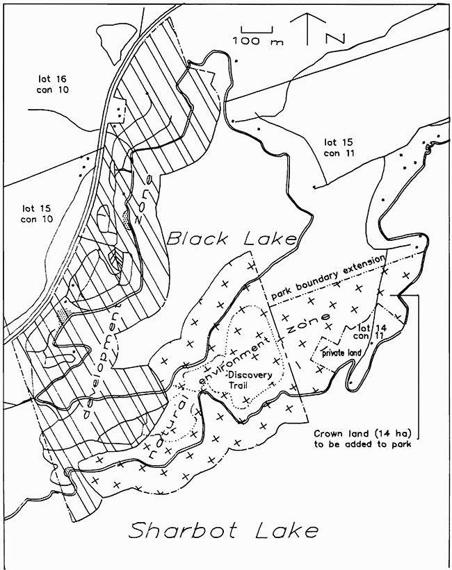
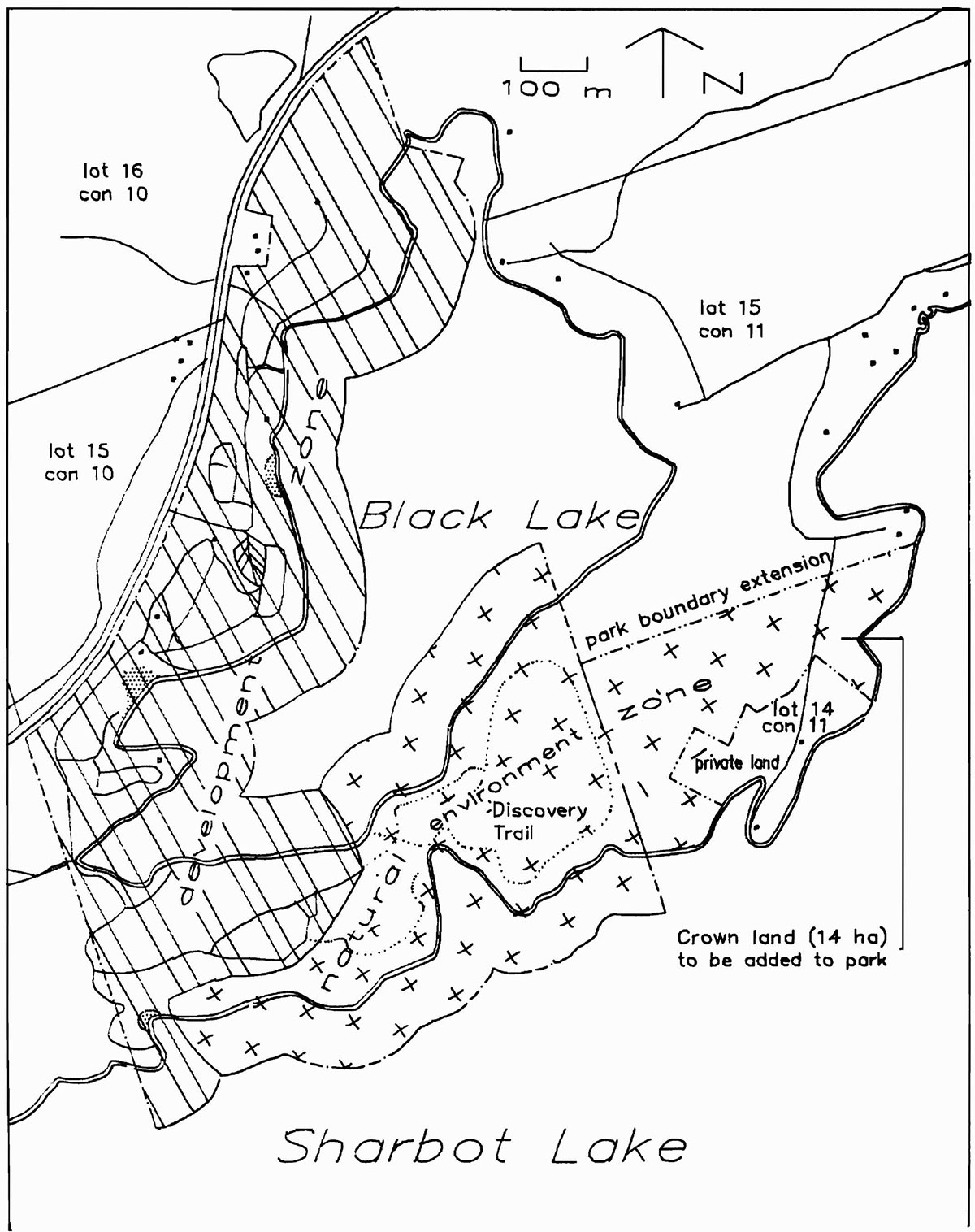
Boundary
Approximately 14 ha of Crown land east of the ridge between Sharbot Lake and Black Lake will be added to the park.21
This area. shown in figure 3, will provide new opportunities to explore and appreciate the park’s natural heritage.
The 14 ha area is described as part of Broken Lot 14, Concession 11 in the Township of Olden.21
Zoning
Two zone designations are used to guide the management of the park: a development zone and a natural environment zone. Development is limited by the ridge south of Black Lake; this ridge marks the boundary between the two zones. See figure 3. All areas will be managed in accordance with ministry management guidelines for the respective zone.15
Development zone
The primary purpose of the development zone (44 ha) is to facilitate intensive development and recreational activities in areas where it can be sustained. This zone encompasses all existing development: day use and campground facilities, park office/gate house, all existing roads, maintenance and service facilities, docks, beaches and comfort station. As shown in figure 3, this zone extends into the adjacent waters.15
This zone has reached its capacity for development and recreational use while maintaining an attractive setting.
Natural environment zone
The primary function of the natural environment zone is the protection and interpretation of the park’s natural features. This zone constitutes all remaining land and waters (39 ha), including the 14 ha addition to the park. Development here will be limited to trails, necessary signs and trail structures to support low-intensity day use recreational activities.15 This zone extends 91 m into adjacent waters, as shown in figure 3.
Resource management
The paik will be managed in accordance with the ministry’s planning and management guidelines for recreation class parks.15 Some specific actions to be undertaken are outlined below. For more information on resource characteristics and development capability see the Background Information Document.21
Land-form
Land-form management will aim to safeguard the land-form heritage while accommodating recreation use. The development zone will require continuous protection against erosion and campsite enlargement. Cuts into the sides of hills to create parking spaces, campsites, roadways and beaches will be naturalized by reducing the degree of slope, planting and/or structurally reinforcing with retaining walls. The natural environment zone will be left to follow its natural progression subject to user safety. Steep sections of the trails require the construction of stairs to prevent trail deterioration.
Water
Water quality will be managed to ensure safe swimming areas and drinking water. The quality of drinking water and water at the beaches is routinely sampled and checked according to standard park operating procedures.
Vegetation
Vegetation will be managed to promote the appreciation of the natural flora, provide attractive settings for recreational activities and ensure visitor safety in the park.
Shrubs will be planted in the Beach Front and Maple Grove Campgrounds to help define campsite boundaries and increase the buffer both between individual campsites and between the campsites and the highway. Pine and spruce trees will be planted along the highway to decrease the visual impact and the noise level of the highway.
Figure 3: Zoning
The abandoned beach area on Sharbot Lake and the boat launch on Black Lake will be restored to reflect original conditions and naturalized by regarding and planting.
In areas of high use and along trails herbicides may be used on poison ivy. The use of insecticides and fungicides will only be undertaken to control severe disease and insect infestation affecting other vegetation, particularly if adjacent property is threatened. Application of herbicides will follow The Pesticides Act and Regulations.
Active vegetation management, such as the removal of hazardous trees, in the natural environment zone will be minimal unless visitor safety is threatened.
Forest fires will be extinguished in keeping with provincial fire management policies and plans.12
The degree to which the objectives (see page 2) of the spray program against gypsy moth have been met will be monitored and evaluated in view of any new control strategies which may be developed by MNR for the eastern region. Results of gypsy moth egg mass surveys by the Canadian Forestry Service3 are as follows.
- 1983: 86 egg masses per hectare
- 1984: 1800 egg masses per hectare
- 1985: 2280 egg masses per hectare
- 1986: 1306 egg masses per hectare
- 1987: 706 egg masses per hectare
Parks staff will monitor gypsy moth at the park and collect field data on it as requested.
Wildlife
The objective of wildlife management is to retain fauna diversity and habitat and to enhance wildlife viewing and interpretive opportunities keeping in mind the recreational objectives and the limited size of the park.
Hunting is not permitted in Sharbot Lake Provincial Park. Trapping of nuisance animals will be undertaken only as required.
Fisheries
The objective of fisheries management is to provide opportunities for recreational fishing while maintaining a healthy fish population.
A fisheries management plan is required to establish proper lake trout management, to detail protective management of spawning beds and to control fishing pressure. Until the plan is prepared fisheries management will be guided by the following.
The park will continue to provide boat and pedestrian access to Sharbot and Black Lakes.
Black Lake and Sharbot Lake will continue to provide very popular sport fishing. Black Lake supports bass, introduced yellow pickerel and a variety of pan fish species while Sharbot Lake supports smallmouth bass, yellow pickerel, northern pike and in the west basin, lake trout. The lake trout population is under stress from overfishing.21
Potential trout spawning areas within the park boundary will be protected from any disturbance or alteration. Shoreline development on Sharbot Lake will be limited to existing facilities.
The park will promote public awareness and appreciation of the fish species found in Sharbot and Black lakes and how this fishery is managed and protected.
Operation
Day to day operation of the yark is guided by the park operating plan.22 In accordance with park management policy (PM 2.49), this plan provides information to park staff on such things as budget, maintenance schedules and emergency services as well as direction for visitor services and marketing.
The plan will be consistent with the Ontario Provincial Parks Provincial Operating Standards16 and will be reviewed annually and updated as required.
Visitor services
The visitor services goal is to enhance the visitor’s experience in the park through a program of communications and limited self-use recreational and interpretive facilities.13
Taking direction from this park management plan and regional visitor services policies13 a visitor services plan will be prepared for the park.
Information
Park staff will provide information to visitors about the Ontario provincial parks system and will familiarize users with park facilities and local and regional attractions such as the MNR White Lake Fish Hatchery.
Park staff will provide information to visitors on MNR's gypsy moth program and on ways they can help reduce the spread of the moth.
Interpretation
The park’s southern Canadian Shield themes of geology, geomorphology and lake ecology will be interpreted through limited self-use facilities and services.
These facilities and services include the Discovery Trail and trail guide, organization of weekend evening programs and special events at the amphitheatre and a kiosk with interpretive information.
Portable displays for the kiosk will be developed to highlight themes of the park and the surrounding area They will be exchanged with displays from Silver Lake Provincial Park.
Subject to park management policies, surrounding community schools and groups will be encouraged to use the park for outdoor educational activities. Resource information will be made available to teachers and other group leaders. There will be no group camping facilities provided.
Recreation
The major recreational pursuits will continue to be camping, swimming, picnicking, boating and relaxation. Informal recreation, fishing, the play area and trails are also available although there will be no organized outdoor recreation programs or activities.
Marketing
To increase use and improve service to visitors a marketing plan will be prepared. Camping is the major attraction of the park and will remain a top priority for marketing. Marketing will focus on increasing use during spring, fall and midweek periods. Educational and community groups will be encouraged to take advantage of the spring and fall seasons.
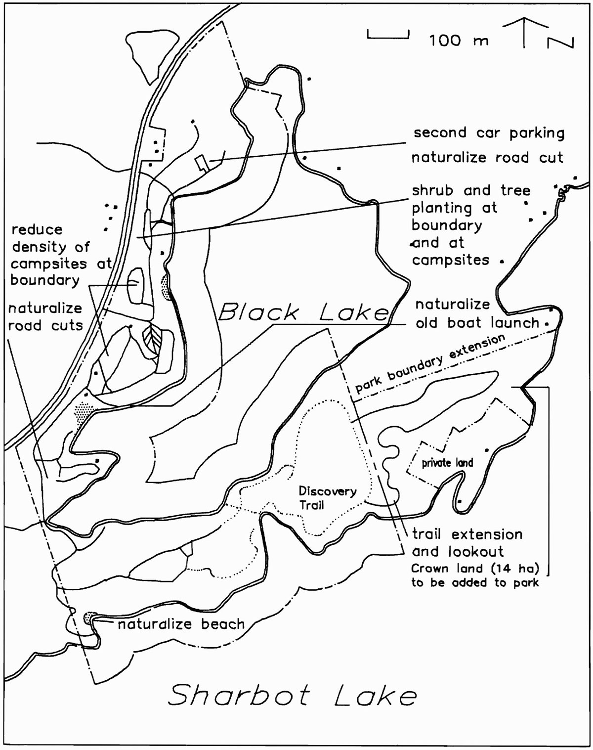
Proposed development
The goal for Sharbot Lake Provincial Park is to provide a wide range of recreational opportunities within the capacity of the land and water base, to encourage the appreciation of its natural heritage and to contribute to tourism in the region. While the park has reached its capacity for development, a number of improvements in keeping with the park’s goal are outlined below. They will proceed according to these guidelines and appropriate site plans. Refer to figure 4.
Figure 4: Proposed Development

Enlarge Figure 4: Proposed Development
Campground improvements
Planting of shrubs and trees will be carried out to provide campsites with increased privacy and buffer from the highway. The practice of taking campsites out of circulation in order to re-establish buffers and ground cover will continue.
Man-made cuts into the sides of hills will be reconstructed to a more natural state by regarding or they will be reinforced with retaining walls.
Campsites in the Beach Front Campground once used as walk-in sites on Black Lake now have vehicular access. The abandoned road along the lakeshore will be upgraded and reopened for camper use. Refer to figure 4.
Between 24 and 30 existing campsites will be provided with electrical service in an area suited to this use.
The parking lot beside the maintenance area will be used to accommodate Beach Front Campground users' additional cars.
Trails
The Discovery Trail will be extended into the proposed land addition following a review of geological and biological information for the area.
Structures, such as stairs, will be built as required on the trails to ensure user safety and prevent site deterioration.
Implementation
The following projects will be undertaken on approval of the management plan. Projects completed will depend on Ministry of Natural Resources' priorities for capital funding. The management plan will be reviewed in 10 years or as the need arises over its 20 year term.
Phase I
Low cost projects to be undertaken as soon as possible:
- put 14 ha of Crown land east of the ridge section into regulation under the Provincial Parks Act
- regrade or restructure man-made cuts into hills in the development areas
- prepare visitor services plan
- prepare fisheries management plan
Phase II
Higher cost projects with potential for generating more park use:
- improve campsites through shrub and tree planting for site privacy, delineation and as a visual and noisebuffer along the highway
- provide electrical service to 24 to 30 existing campsites
- design and install structures for pedestrian traffic in areas with potential and existing erosion problems
- develop trail loops off the Discovery Trail
- restore to original natural conditions the old boat launch on Black Lake and the old beach on Sharbot Lake
- upgrade washroom facilities
Public consultation
Comments on the park’s future management were invited during the management planning process. The preliminary management plan was made available to park users, local governments, adjacent land owners, local clubs and others with an interest in the management of the park. The Background Information Document 21 was also available for review. Both the preliminary plan and the background document were available at the park and the district office in Carleton Place.
There was minimal response to the preliminary plan and no major concerns were raised. Incorporating some minor changes and updating,this approved management plan confirms the park policies set out in the 1986 preliminary plan. This 1988 plan will guide the management of Sharbot Lake Provincial Park for the next 20 years.
Bibliography
1. Ayer, Ralph David. A Historical Geography of Oso Township Frontenac County. Unpublished report. Tweed: 1972.
2. Canadian Forestry Service and Ontario Ministry of Natural Resources. The Gypsy Molh. Leaflet, Catalog Number: Fo29-l/5-1983E. Sault Ste. Marie: Great Lakes Forest Research Centre Information Office, 1983.
3. Canadian Forestry Service. Results of gypsy moth egg mass surveys. Unpublished reports. Sault Ste Marie: Forest Insect and Disease Survey Unit, 1983 to 1986.
4. Crowe, R.B., G.A. Mackay and W.M. Blake. The Tourist and Outdoor Recreation Climate of Ontario Vol.1 and Hull: Ministry of Supply and Services Canada, 1972.
5. Cuddy, Donald. Sharbot Lake Provincial Park Life Science Check Sheet Unpublished report Kemptville: Ontario Ministry of Natural Resources, 1978.
6. Doane, Charles C. and Michael L. McManus, editors. The Gypsy Moth: Research Toward Integrated Pest Managment. Technical Bulletin 1584. Washington, D.C.: United States Department of Agriculture, 1981.
7. Ontario Department of Energy and Resources Management. Mississippi Valley Conservation Report Vol.1 Toronto: 1970.
8. Ontario Ministry of Natural Resources. 1983 Park Marketing Plans and Marketing Highlights. Unpublished report. Tweed: 1983.
9. Ontario Ministry of Natural Resources. 1983 Provincial Park Camper Survey Summary Statistical Report. Unpublished report. Toronto: Parks and Recreational Areas Branch, 1983.
10. Ontario Ministry of Natural Resources. 1983 Provincial Park Day User Survey Summary Statistical Report. Unpublished report. Toronto: Parks and Recreational Areas Branch, 1983.
11. Ontario Ministry of Natural 1985 Gypsy Moth Aerial Spray Proposal For The Eastern Reigon. Unpublished report. Kemptville: 1984.
12. Ontario Ministry of Natural Resources. Aviation and Fire Management Policy AF.03.01.01. Sault Ste. Marie: Aviation and Fire Management Centre, 1983.
13. Ontario Ministry of Natural Resources. Eastern Region Provincial Parks Visitor Services Policies and Guidelines Manual. Limited publication. Kemptville: Parks Branch, 1986.
14. Ontario Ministry of Natural Resources. Gypsy Moth Update. Published report. Tweed: 1986.
15. Ontario Ministry of Natural Resources. Ontario Provincial Parks Planning and Management Policies. Toronto: Parks and Recreational Areas Branch, 1978.
16. Ontario Ministry of Natural Resources. Ontario Provincial ParkS Provincial Qperatini Standards. Publication Number 3691. Toronto: Parks and Recreational Areas Branch, 1986.
17. Ontario Ministry of Natural Resources. Ontario Provincial Parks Statistics 1981. Toronto: Parks and Recreational Areas Branch, 1982.
18. Ontario Ministry of Natural Resources. Ontario Provincial Parks Statistics 1984. Publication Number Toronto: Parks and Recreational Areas Branch, 1985.
19. Ontario Ministry of Natural Resources. Ontario Provincial Park Statistics 1985. Publication Number Toronto: Parks and Recreational Areas Branch, 1986.
20. Ontario Ministry of Natural Resources. Ontario Provincial Parks Statistics 1986, Publication Number 5628. Toronto: Parks and Recreational Areas Branch, 1987.
21. Ontario Ministry of Natural Resources. Sharhot Lake Provincial Park Background Information Document, Unpublished report. Kemptville: Parks Branch, 1985.
22. Ontario Ministry of Natural Resources. Sharbot Lake Provincial Park Management/Operatin Plan. Unpublished working manual, updated annually. Tweed: 1976.
23. Ontario Ministry of Natural Resources. Sharbot Lake Provincial ParkPolicy Statement. Unpublished report Kemptville: Parks Branch, circa 1974.
24. Ontario Ministry of Natural Resources. Silver Lake Provincial Park Management Plan 1985. Publication Number 3125-1. Kemptville: Parks Branch, 1985.
25. Ontario Ministry of Natural Resources. Tweed District Land Use Guidelines. Publication Number 5885. Tweed: 1983.
26. Ontario Ministry of Transportation and Communications. Provincial Highways. Traffic Volumes: 1983 King’s Highways. Secondary Highways Tertiary Roads.. Toronto: The Provincial Highways Program Planning Information Group, 1983.
27. S. Wilkins. Preliminary Report of Gypsy Moth in Sharbot Lake Provincial park. Unpublished report. Tweed: Ontario Ministry of Natural Resources, 1983.
28. Tourism and Outdoor Recreation Planning Study Tourism and Recreational Behaviour of Ontario Residents. Volumes 1 to 8. Toronto: Queen’s Park, 1977.
29. Woerns, Norbert. Earth Science Inventory Checklist. Sharhot Lake Provincial Park;. Unpublished report. Toronto: Ontario Ministry of Natural Resources, 1977.
30. Wolff, J.M. Geoloy of Sbarbot Lake Area. Frontenac and Lanark Counties. Southeastern Ontario. Publication Number 5336-1. Toronto: 1981.