Shawanaga Lake Conservation Reserve Management Statement
This document provides policy direction for the protection, development and management of Shawanaga Lake Conservation Reserve and its resources.
Statement of Conservation Interest (C101)
March, 2003
Ministry of Natural Resources
Parry Sound District
Prepared with the assistance of:
Meteek & Company
Huntsville, Ontario
Approval statement
We are pleased to approve this Statement of Conservation Interest for Shawanaga Lake Conservation Reserve (C101).
Shawanaga Lake Conservation Reserve is a 4,937 hectare area of Crown land in the Territorial District of Parry Sound. It is located within the Municipality of Whitestone (western Hagerman Ward and eastern East Burpee Ward). To the east, it extends to within 5 kilometres of the hamlet of Dunchurch. It is bordered to the west by the Canadian National Railway line and to the north by Snakeskin Lake. To the south, it touches a portion of Shawanaga Lake.
Most of the adjacent lands to the south, south-west and south-east are privately owned, and there are several other privately owned parcels adjacent to other boundaries; these lands are not part of the conservation reserve and will remain privately owned.
This conservation reserve is within ecological Site District 5E-7, and provides ecological representation of 15 combinations of vegetation and landforms. These include hemlock, sugar maple and white birch forests, as well as open and treed wetlands, and rock barrens, on low hills with sandy soils, and similar forests on hilly bare bedrock and flat sand deposits. This site provides inland habitat for the nationally threatened eastern massasauga rattlesnake.
The area is used for a variety of traditional uses, including hunting, fishing, fur harvesting and snowmobiling. The "Pike’s Peak" and "Old Baldy" portions of the site are considered very scenic.
Shawanaga Lake Conservation Reserve is one of 378 new protected areas approved through Ontario’s Living Legacy Land Use Strategy, aimed, in part, at completing Ontario’s system of parks and protected areas.
During the "Lands for Life" planning process, the public was widely consulted and provided valuable input into what became Ontario’s Living Legacy Land Use Strategy. During consultation related to the formal Public Lands Act (Ontario Regulation 805/94) regulation of the boundaries of this conservation reserve (in 1999 and 2000) a number of minor boundary changes were made to reduce resource management conflicts, ensure the boundaries reflected areas requiring protection. Comments received during the consultation were generally supportive of the protection of this area. Stakeholders who provided comment during the earlier consultation for this site were subsequently consulted regarding the draft Statement of Conservation Interest and their comments were considered in the finalization of this document.
This Statement of Conservation Interest provides guidance for the management of the conservation reserve and provides the basis for the ongoing monitoring of activities. More detailed direction is not anticipated at this time. Should more complex resource management or conservation issues arise or significant facility development be considered, then a detailed Resource Management Plan will be prepared with full public consultation.
Shawanaga Lake Conservation Reserve is managed under the direction of the District Manager and the Parry Sound Area Supervisor of the Ministry of Natural Resources, Parry Sound District.
Approved by:
R. Griffiths
District Manager
Parry Sound District
Approved by:
Ron Running
Regional Director
Southcentral Region
1.0 Introduction
Ontario’s Living Legacy, the result of an extensive planning process that began in early 1997, culminated in the approval in July 1999 of a Land Use Strategy that identifies the intended strategic direction for Crown land, including the completion of Ontario’s system of parks and protected areas. This process, which included extensive public consultation, resulted in the recommendation for regulation of 378 new protected areas, including Shawanaga Lqke Conservation Reserve (C101).
Shawanaga Lake Conservation Reserve is a 4,937 hectare area of Crown land in the Territorial District of Parry Sound. It is located within the Municipality of Whitestone (western Hagerman Ward and eastern East Burpee Ward). To the east, it extends to within 5 kilometres of the hamlet of Dunchurch. The conservation reserve is bordered on the north by Snakeskin Lake and on the south by portions of Shawanaga Lake. Highway 124 passes within a couple of kilometres to the south east of the reserve, and in the west the Canadian Pacific Railway main line forms part of its boundary. The majority of the conservation reserve’s catchment area drains southward into Shawanaga Lake, thence into Shawanaga River and Georgian Bay. This drainage pattern provides a species migration corridor to Georgian Bay and its coastal barrens. Similarly, the northern portion of the site drains into Snakeskin Lake and eventually into the Magnetawan River, and also functions as a species migration corridor connection to Georgian Bay.
This conservation reserve, is within ecological Site District 5E-7 (northern portions of site) and 5E-8 (southern portions of site). It was identified during the Ontario’s Living Legacy selection process for the number and variety of wildlife habitats and landscape features contained in a single, contiguous and remote Crown land parcel. These include eastern white cedar (Thuja occidentalis), eastern hemlock (Tsuga canadensis), sugar maple (Acer saccharum) and white birch (Betula paperifera) forests, as well as open and treed wetlands, and rock barrens, on low hills with sandy soils, and similar forests on hilly bare bedrock and flat sand deposits. It is known to provide inland habitat for the nationally and provincially threatened eastern massasauga rattlesnake (Sistrurus catenatus catenatus) and eastern hognose snake (Heterodon platyrhinos).
The area is used for a variety of traditional uses, including hunting, fishing, fur harvesting and snowmobiling. Two lookout points, locally referred to as "Pike’s Peak" and "Old Baldy", provide scenic vistas over portions of the conservation reserve and its surrounding landscape.
Crown lands to the west of much of this site lie within the North Parry Sound Area Enhanced Management Area- Recreation (E119r).
Conservation reserves are established under the authority of the Public Lands Act, Ontario Regulation 805/94. Shawanaga Lake Conservation Reserve was established by Ontario Regulation 86/01, an amendment of the Public Lands Act, on April 21, 2001.
A sliver of Crown land in Lots 1 and 2, Concession 13, Hagerman Township was unintentionally included in the final regulation plan for this site. This will be corrected to conform to the intended boundary of this site, including the 2000 consultation map.
A Statement of Conservation Interest (SCI) is prepared under the authority of Procedural Guideline A - Resource Management Planning (PL. Procedure 3.03.05). The purpose of this SCI is to identify and describe the values of Shawanaga Lake Conservation Reserve. The SCI also outlines the activities that currently occur within the conservation reserve and provides guidelines for the management of current and future activities in the context of protecting the natural, recreational and cultural values.
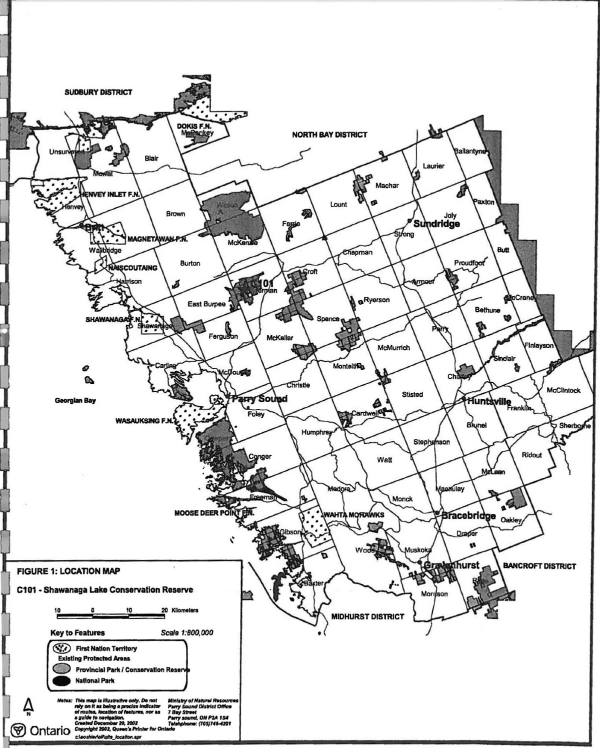
Figure 1: Location of Shawanaga Lake conservation Reserve

Enlarge Figure 1: Location of Shawanaga Lake conservation Reserve
Figure 2: Site Map - Shawanaga Lake Conservation Reserve (C101)
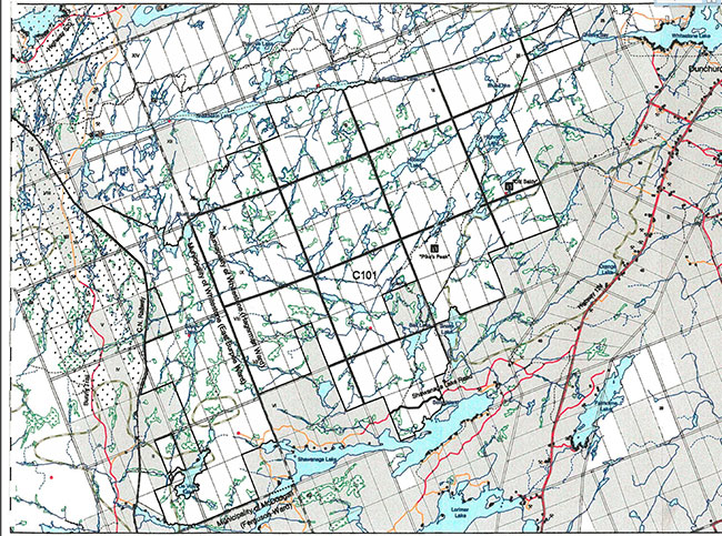
Enlarge Figure 2: Site Map - Shawanaga Lake Conservation Reserve (C101)
1.1 Background information:
| Name | Shawanaga Lake Conservation Reserve (C101) |
|---|---|
| Site Region/District | 5E-7 and 5E-8 |
| OMNR Administrative Region/District/Area | Southcentral Region/Parry Sound District/ Parry Sound Area |
| Total Area (ha.) | 4,937 hectares |
| Regulation Date | April 21, 2001 (O. Reg. 86/01) |
| First Nations | Robinson-Huron Treaty |
| OBM map sheets | 10 7 5750 50450, 10 17 5800 50450, 10 17 5750 50500, 10 17 5750 50500, 10 17 5800 50500, 10 17 5800 50550, 10 17 5850 50550 |
| Topographic Map | Magnetawan 31E/12 and Pointe Au Baril Station 41 H/9 |
| UTM co-ordinates | 17T 59790 505220 (Centroid) |
1.2 Representation:
Earth science representation:
Bedrock - Whitestone Suite meta-anorthosite in the western part of the Parry Sound Domain, Parry Sound Terrane in the Proterozoic Central Gneiss Belt of the Grenville Province.
Surficial - thin, discontinuous drift cover over bedrock, bedrock drift complex, loose, stony and sandy till, and sandy till of glaciolacustrine and sandy and gravelly till of glaciofluvial ice-contact origins and glaciolacustrine deposits are typical components of the Late Wisconsinan Stage of the Quaternary Era in southwestern Ontario.
Life science representation:
A large area of remote forest and rock barrens interspersed with wetlands, with a diversity of botanical and wildlife habitats, including:
- A pattern of low ''whaleback" ridges and intervening wetlands
- High rock ridges with partially forested slopes and rock barren hilltops
- Upland forested areas dominated by white pine (Pinus strobus), eastern hemlock, red oak (Quercus rubra), and red pine (Pinus resinosa)
- Bare rock hill-tops and ridges that support stunted red oak, white pine, common juniper (Juniperis communis), and common hairgrass (Deschampsia nexuosa)
- Extensive area of wetlands, broken into small pockets, varying from graminoid/sedge marshes to densely tangled alder/mountain holly swales, to bogs and fens and tamarack fens
Cultural resources representation:
Neither detailed cultural research nor inventory has been carried out for this conservation reserve. However, there is some site evidence of early logging activity, probably ending by the 1940s. The conservation reserve is a part of two separate river systems which have historical significance: the northerly portion drains toward the Magnetawan River, and the southerly portion drains into Shawanaga Lake and thence into Shawanaga River and Georgian Bay.
Recent regional evaluation (OMNR, 2003) shows that this conservation reserve contains areas that have a high potential for cultural heritage sites. There are registered cultural heritage sites identified to the east of the conservation reserve near Dunchurch.
Recreational opportunities:
A recreational inventory report was prepared for this site based primarily on existing knowledge and data sources of MNR staff, and reflecting field observations made during the preparation of the life science report (Brown, 2002). The area is recognized as providing many recreation opportunities. It accommodates big and small game hunting, snowmobiling, and sport fishing. All-terrain vehicle use occurs on trails that appear to be associated with authorized recreation camps. Four recreation camps, authorized by MNR through the Public Lands Act, Ontario Regulation 805/94, are located within the conservation reserve and three others are located close to the boundaries of the conservation reserve.
Two high areas popular as lookout points are located within the conservation reserve, and are locally important.
1.3 Survey work:
| Survey Level | Earth Science | Life Science | Cultural | Recreational | Other |
|---|---|---|---|---|---|
| Reconnaissanoe | Duba & Frey, 2001 | Blythe & Assoc., 2002 | OMNR, 2003 | Brown, 2002 | None |
| Detailed | None | None | None | None | None |
| Requirement | None | Monitor the status/presence of significant species and associations. | Research to be encouraged | Monitor use impacts | None |
2.0 Values to be protected
The northern portions of this conservation reserve are located within Hills' (1959) ecological Site District 5E-7, while the southern portions are within SE-8. Values include earth science, life science and recreational/aesthetic values, with an emphasis on the life sciences.
2.1 Earth science:
(Earth science information, unless otherwise noted, is taken from Duba and Frey, 2001)
Bedrock:
Shawanaga Lake Conservation Reserve is an area of extensive bedrock barrens interspersed with numerous lakes, interconnecting drainages and wetlands. The dominant rock types exposed are Whitestone Suite meta-anorthosite in the western part of the Parry Sound Domain, Parry Sound Terrane in the Proterozoic Central Gneiss Belt of the Grenville Province.
The Grenville Province is the product of thrusting and imbrication of the crust to the northwest as it collided with a continental landmass to the southeast. The Grenville Orogeny, circa 1140 to 1070 million years ago, culminated more than 500 million years of crustal evolution. The eroded roots of the products of these events are displayed in the complexly metamorphosed and deformed rocks of the region (Easton, 1992b).
The Parry Sound Terrane is one of four lithotectonic terranes of the Central Gneiss Belt Within the Parry Sound Terrane, the Parry Sound Domain is one of three structural domains. This geological environment is part of the modem organization of the complex products of the mid-Proterozoic Grenville orogenic events (Easton, 1992a & b). As such, their representation in Shawanaga Lake Conservation Reserve contributes to the conservation of the Grenville continental accretion theme outlined by Davidson (1981).
Within the Ontario Provincial Park system, the bedrock geological features of Shawanaga Lake Conservation Reserve have regional significance in the representation of early to syntectonic metaplutonic component of the western part of the Parry Sound Domain, Parry Sound Terrane.
Surficial:
Glacial striae on exposed bedrock provide evidence of the Late Wisconsinan glaciation. The area was flooded in the expansion of glacial Lake Algonquin during deglaciation, after about 11,500 years before present (BP) (Eschman and Karrow, 1985). With the retreat of the ice-front retreat north and northeasterly, and the opening of successively lower outlets in the North Bay area, about 10,200 years BP, the glacial lake drained rapidly to the low level of glacial Lake Hough and the region was exposed for the first time since the onset of deglaciation.
More than 80% of the conservation reserve is underlain by thin, discontinuous drift cover (<1 m) over bedrock (Kor and Delorme, 1989a and b) and bedrock drift complex. Other areas include thin discontinuous, loose, stony and sandy till reflecting the coarse-grained, quartzofeldspathic composition of the underlying bedrock; and sandy till of glaciolacustrine and sand and gravel of glaciofluvial ice-contact origins. A sub-glacial melt-out till covers a very small area in the southwestern part of the conservation reserve. This till is loose, stony and sandy. It is generally greater than 1 m thick and occupies lee-side (down-ice) bedrock hollows.
Organic deposits underlie the low relief terrain between uplands and are occupied by drainages and wetlands.
The surficial geological features are locally significant. The tills, sandy till of glaciolacustrine and sandy and gravelly till of glaciofluvial ice-contact origins, and glaciolacustrine deposits are typical components of the Late Wisconsinan Stage of the Quaternary Era in southwestern Ontario.
2.2 Life science:
(Life science information, unless otherwise noted, is taken from Blythe & Associates, 2002)
In late May 1997, the Ministry of Natural Resources (Natural Heritage Information Centre and Natural Heritage Section) carried out a natural heritage "gap analysis" project for Site District 5E-7 and 5E-8, in conjunction with Ontario Living Legacy’s Land Use Planning. The purpose of the gap analysis was to identify different vegetation and landform combinations that were not included in protected areas at that time. Geographic Information Systems technology was used and applied to the· following criteria: representation of landform vegetation patterns, diversity, condition, ecological considerations; and special features (Crins and Kor, 1998).
The southern portions of Shawanaga Lake Conservation reserve were identified through this gap analysis.
Representation:
Shawanaga Lake Conservation Reserve encompasses a large area of remote forest, and rock barrens habitat interspersed with wetlands. Owing to its relatively large size, the site contains a diversity of botanical and wildlife habitats. The terrain is difficult to traverse by foot, or motorized vehicle, and for the most part the conservation reserve is relatively undisturbed in terms of human activity.
Throughout much of the site, the topography repeats a pattern of low "whaleback" ridges and intervening wetland swales- thick tangled growths of speckled alder (Alnus incana ssp. rugosa) and mountain holly (Nemopanthus mucronatus) dominate these swales. Along the southern boundary of the conservation reserve, and in the northeast quadrant, there are high rock ridges with partially forested slopes and rock barren hilltops. A particularly spectacular example of this overlooks the north shore of Shawanaga Lake. Another such hilltop feature is located in the northeast quadrant of the reserve and is known as Pike’s Peak.
The landscape of this site has been heavily influenced by glacial scouring, followed by erosion and reworking by the receding waters of post-glacial Lake Algonquin. These factors, in combination with logging activities of the late 19th and early 20th centuries and the influence of one, or more, large post-logging forest fires, have created the present day forest environment that exists in the conservation reserve.
This landscape is invariably associated with a very shallow, to a non-existent, covering of glacial till soils of the Monteagle Gravelly Sandy Loam Complex (Hoffman et al. 1962). The exceptions to this general trend are the frequently occurring shallow depressions in the bedrock. The soils are deeper in these low lying areas, since the eroded soil from the original pre-logging soil mantle has accumulated in these depressions. Where the soil drainage is imperfect, owing to a perched water table, this sandy soil is overlain with organic muck soils.
In the southeast quadrant, near Bell Lake, white pine, eastern hemlock, red oak, and red pine dominate the upland forested areas. These are large, mature, cathedral-like forests that have deeply shaded open understories where few herbaceous plants can survive. These forest stands appear to have remained undisturbed since the logging activity of the late 19th and early 20th centuries. The hilltops and ridges in this area are bare rock knobs that support stunted red oak, white pine, common juniper and common hairgrass.
The valley forests, between the rock hills and ridges, offer deeper soil conditions, where large diameter red oak, yellow birch (Betula alleghaniensis) and white birch grow. To a lesser degree, these valley forests also support large individual specimens of white pine and eastern hemlock. The associated forest understory within these valley forests includes a greater diversity of herbaceous plants such as, wild sarsaparilla (Aralia nudicaulis). starflower (Trientalis borealis). long-awned wood grass (Brachyelytrum erectum) and intermediate woodfem (Dryopteris intermedia).
In the valleys associated with fault lines, the valley slopes are forested with mature white pine and red pine, while the valleys themselves contain a variety of wetland features. Two of the most common wetland types are graminoidlsedge meadows, and flooded rock valleys filled with aquatic vegetation, specifically, fragrant water lily (Nymphaea odorata), bullhead lily (Nuphar variegatum), and watershield (Brasenla schreben).
In the southwest quadrant of the conservation reserve, the topography is less spectacular in aspect and features a pattern of low uwhaleback" ridges and intervening shallow shrub dominated wetlands and pothole lakes. Occasionally, the intervening shallow valleys support hardwood forests dominated by immature stands of red oak, trembling aspen (Populus tremuloides) and largetooth aspen. The presence of these latter two shade intolerant species, as well as the relatively small size of the trees, indicates this area has been subject to recent fires, perhaps within the last 60 to 90 years. Similarly, forests in the heart of the reserve are middleaged stands of white birch, largetooth aspen and trembling aspen. These species are also indicative of relatively recent occurrences of fire. Owing to the difficult terrain, and poor access, the entire southwest quadrant is remote and totally lacking in any recent evidence of anthropogenic disturbance, save fires.
The northern portion of the conservation reserve is similar in aspect to much of the southwest quadrant with a relatively low profiled topography. The soils are different, however, since there is a shallow mantle of gravelly sand covering the bedrock. This has fostered the growth of a somewhat richer forest. Much of the terrain is dominated by young mixedwood forests of white birch, trembling aspen, largetooth aspen, sugar maple, white spruce (Picea glauca), balsam fir (Abies balsamea) and red maple. This forest is interspersed with low ridges of bare rock. Throughout this portion of the conservation reserve, there is evidence of fires 60 to 90 years ago.
Although less prevalent, the northeast quadrant also contains mature, valley, mixedwood forests with relatively large yellow birch, sugar maple, white pine, and eastern hemlock. Some white pines are exceptionally large and may be 120 years of age or older. The higher elevations associated with this mature forest are rock barrens. These rock barrens are lightly covered with a mantle of gravelly sand that supports a sparse growth of white pine and stunted sugar maple.
There are a variety of wetland features found within the conservation reserve. These range from the most common beaver dam controlled ponds and drained beaver meadows, to an assortment of fens, some of which exhibit bog characteristics, with typical fen/bog flora, such as: pitcher plant (Sanacenia pu purea), sundew (Drosera spp.), beakrush (Rhynchospora spp.) and tawny cotton grass (Eriophorom virginicum), sphagnum moss (Sphagnum spp.), black spruce (Picea mariana), tamarack (Larix laricina), pitcher plant, small flowered cranberry (Vaccinium oxycoccus), tawny cotton grass and spatulate-leaved sundew (Drosera intermedia) and yellow-eyed grass. The latter species, yellow-eyed grass, is a post-glacial disjunct species usually associated with Atlantic coastal plains flora (ACPF). This species is considered provincially rare. In addition, some of the more common ACPF species, such as twig rush (Ciadium mariscoides), pickerel weed (Pontederia cordata) and floating heart (Nymphoides cordata) were observed throughout the conservation reserve during recent field inventory.
Condition:
There is a wide variety of terrain types and drainage patterns within the conservation reserve. The topography itself is an impediment to human access and a key feature in the site’s relatively undisturbed state. All of the forest types have been heavily influenced by fire and are in a variety of successional stages. Indeed, the majority of the conservation reserve shows evidence that it had a fire-dependent ecosystem prior to the square timber logging era and is currently in the process of re-establishing a similar fire-dependent regime.
There have been no recent resource extraction activities in the conservation reserve, although there is ample evidence of logging activity throughout the site during the late 19th and early 20th century.
Portions of the conservation reserve are accessed by an OFSC snowmobile trail (#808) and a number of all:. terrain vehicle trails that are primarily associated with authorized recreation camps. The remainder of the conservation reserve is relatively inaccessible because of the absence of roads on the Crown and private lands that surround it.
Diversity:
Owing to the size of the conservation reserve, it provides a diversity of floral and faunal habitats ranging from the relatively nutrient poor areas of the rock barrens to the fertile graminoid/sedge wetlands and the silt loam pockets that support mature bottomland forests. In general, the areas of the conservation reserve richest in species are those valley bottomlands and associated wetlands. Although most of the botanical species which were recorded in the summer botanical survey of 2002 were relatively common, one, yellow-eyed grass (Xyris difformis), was found to be provincially significant.
There is a wide variety of terrain types and drainage patterns within the conservation reserve. This is the primary contributing factor to the large range of vegetation communities and wildlife habitats. The common influence on the vegetative communities throughout the conservation reserve is a general lack of soil. The exposures of bedrock vary from steep hills and promontories, to the more common low whaleback ridges. The topography itself is an impediment to human access and a key feature in the conservation reserve’s relatively undisturbed state.
In general, the northern part of the conservation reserve has more fertile soil conditions and a more diverse assemblage of botanical species. It has also been the most recently affected by fire.
There are extensive areas of wetlands broken into small pockets by the intervening rock ridges. These wetlands vary from typical graminoid/sedge beaver meadows to densely tangled alder/mountain holly swales, to bogs and fens, to the less common mature tamarack fens. These wetland features tend to produce the largest numbers of botanical species, as well as, provide the richest habitats for wildlife.
There is a diversity of forest cover. The early successional forests in the northern part of the conservation reserve are evolving into mixedwood stands of sugar maple, yellow birch, white spruce, and balsam fir. They are moderately rich, but have unremarkable forest floor botanical species assemblages. In the southeast quadrant, there are mature conifer dominated forests that appear to have been undisturbed since the logging era. The understory flora in these forests is very sparse and limited to a few species which can tolerate the densely shaded and acidic forest floor conditions. Also present in the southern portion of the site are relatively immature stands of red oak, trembling aspen and largetooth aspen. In these forest stands the understory species are similar to those in the northern mixedwood stands.
From a wildlife perspective, the conservation reserve has a number of significant values. Its relative remoteness, size, and lack of anthropogenic disturbance throughout provide ideal conditions for numerous species. In particular, the mixture of rock ridges, assorted wetlands and tolerant hardwood forests provides a large contiguous area of suitable habitat for several herpetofaunal species including, the threatened eastern hognose snake. There have also been confirmed reports of eastern massasauga rattlesnakes inhabiting the conservation reserve both in the south and in the north near Snakeskin Lake. The connection with the Georgian Bay coastal barrens, via the valley of the Shawanaga River is a key factor in the presence of these two nationally and provincially threatened species. This coastal connection, along with the mixture of exposed rock and adjacent wetland areas, may also provide suitable habitat for the five-lined skink (Eumeces fasciatus). This species, Ontario’s only lizard, is known to occur in similar habitats in the Wahwashkesh Lake, Island Lake and Magnetawan River valley areas, approximately 7 kilometres north of the Shawanaga Lake Conservation Reserve; there are reports that this species may have expanded its range into the southeastern quadrant of this site.
The area appears to offer a suitable range of habitats for wildlife species typical to the region, such as: moose, white-tailed deer, black bear, beaver (Castor canadensis) and racoon (Procyon lotor). Similarly, the various forest and wetlands provide a wide range of breeding habitats for many different avian species. The presence of red oak as a significant component of the mid-tolerant forest found in areas of deeper soils and on the rock barrens is of particular note. The red oak acorn mast crop is highly attractive to white-tailed deer and black bear, and a number of other species in the late summer and autumn.
Ecological considerations:
By virtue of its large size, difficult terrain, relatively undisturbed condition, remote characteristics and large variety of vegetation communities, this conservation reserve provides many types of wildlife habitat of particular importance is its linkage with Georgian Bay and the coastal barren environment by way of the Shawanaga River. It is also proximal to the Magnetawan River in the north, which also has a direct linkage to Georgian Bay. These coastal connections and a sufficiently mild inland climatic regime combine to make this a critical refuge for the threatened eastern massasauga rattlesnake and eastern hognose snake.
These same factors may make some of its wetlands and lakeshore margins a refuge for Atlantic coastal plains flora. Although only one rare species of ACPF was noted in the 2002 survey, the conservation reserve has the potential to harbour other rare species of this post-glacial disjunct botanical assemblage.
This reserve is also relatively close to the larger conservation reserve, Ahmic Forests and Rock Barrens (C99), with which it has a reasonably undisturbed connection of forested lands. This would allow the passage of wildlife between the two areas.
Special features:
The conservation reserve provides a large area of inland habitats for the eastern hognose snake and eastern massasauga rattlesnake. It also has a high potential to contain habitats for the five-lined skink and ACPF botanical species.
2.3 Cultural values:
While no specific cultural studies or inventories have been undertaken within the conservation reserve, and no major cultural resource values have been evaluated or identified to date, there is physical evidence of early logging throughout this conservation reserve. These include the remains of what is believed to be a camboose shanty, a stable, and associated outbuildings on the south shore of Snakeskin Lake (Blythe & Associates, 2002).
There is some indication that older footpaths and portage trails in both the south and north of the reserve may have been part of a larger network of First Nation trails. The proximity of this area to two historically significant rivers, the Magnetawan and the Shawanaga, both having a direct connection to Georgian Bay, lends credence to this speculation. Recent regional evaluation (OMNR, 2003) shows that this conservation reserve contains areas that have a high potential for cultural heritage sites. There are registered cultural heritage sites identified to the east of the conservation reserve near Dunchurch.
2.4 Recreational/aesthetic values:
Hunting and fishing appear to be the primary recreational activities, which have traditionally occurred within the conservation reserve’s boundaries. There are four authorized recreation camps within the conservation reserve and three more exist close to reserve boundaries on adjacent Crown land.
The conservation reserve supports the usual populations of large and small game. Most hunting activity within the site is focused on white-tailed deer (Odocoileus virginiana), moose (Aices alces), and black bear (Ursus americanus).
Sport fishing opportunities are provided on several of the lakes within and adjacent to Shawanaga Lake Conservation reserve. OMNR records indicate there are game fish species in at least six of the waterbodies within the conservation reserve’s boundaries. Shawanaga Lake contains smallmouth bass (Micropterus dolomieui), northern pike (Esox lucius), and cisco (Coregonus artedii). Bell Lake, Snake Lake, Snakeskin Lake, Hobson Lake, and Boyd Lake all support populations of smallmouth bass. These smallrnouth bass populations are believed to have been the result of successful stocking programs by the OMNR/ Department of Lands and Forest, or through the efforts of local fishing enthusiasts.
Shawanaga Lake Conservation Reserve is crossed by the Dun-Ahmic Snow Riders Trail # 808, which runs roughly south to north from Shawanaga Lake. Three other trails outside of the conservation reserve (TransOntario Provincial connector Trail #C104D, and Dun-Ahmic Snow Riders Trails #602 and 603) connect to Trail #808, funneling their traffic through the site.
All-terrain vehicle use of the site has increased in recent years, with access gained by way of the snowmobile trails and other old trails. Most of the all-terrain vehicle trails that have developed appear to be associated with a number of recreation camps within and near the conservation reserve.
3.0 Management guidelines
3.1 Land tenure:
Background:
Shawanaga Lake Conservation Reserve comprises 4,937 hectares of Crown land.
All of the adjacent lands to the south, southwest and southeast are privately owned (except for Lot 8, Concession, East Burpee Township), and there are several other privately owned parcels adjacent to other boundaries. These lands are not part of the conservation reserve and will remain privately owned.
Road allowances in the Hagerman Township portion of the conservation reserve remain under the authority of the Municipality of Whitestone wherein they lie, and are not included as part of the conservation reserve. This includes the portion of a colonization road in Hagerman Township (now Shawanaga Lake Road). The extension of this colonization road into East Burpee Township is not part of the legally recognized colonization road and is therefore included as part of the conservation reserve. The former road allowances in the East Burpee portion of the site were stopped up and closed in December 1999, and are therefore part of the conservation reserve.
The conservation reserve is divided between two OMNR Bear Management Areas (PS-49-004, and PS-49- 005). There are also four OMNR registered traplines that have portions of their harvest areas within the conservation reserve. There is one known trappers cabin within the site. The conservation reserve lies within parts of four commercial Bait Fish Blocks. Two of these currently assigned (Hagerman 1 & 4) and two are not (East Burpee 2 & 3).
There are four recreation camps within the conservation reserve and an additional three are located on adjacent Crown land, all authorized by Land Use Permits under the authority of the Public Lands Act, Ontario Regulation 805/94.
The conservation reserve is traversed by one snowmobile trail authorized by land use permit The Ontario Federation of Snowmobile Clubs (OFSC) Trans Ontario Provincial Connector Trail, CBOB, more-or-less bisects the site on a north-south axis.
Guideline:
The sale of Crown lands within the conservation reserve generally is not permitted. Exceptions will only be considered under unusual circumstances, such as where an adjacent privately owned parcel has inadequate area for the installation of a septic system.
There are no plans by the MNR to acquire private lands to add to the conservation reserve.
The commercial bear hunting service associated with the current Bear Management Areas is allowed to continue. Fur harvest is permitted to continue in the registered trapline areas. The Bait Fish Blocks that are currently assigned are permitted to continue. Bait Harvest Areas, which are currently unassigned, may be reassigned to future applicants.
The existing recreation camps within the conservation reserve are permitted to continue. They may be eligible for "enhanced" tenure, but are not eligible for purchase of land. (See Appendix 4)
New recreation camps are not permitted.
3.2 Development:
Background:
There are no Crown owned buildings or other facilities within the conservation reserve.
Access to the southern part of the conservation reserve is very good from the Shawanaga Lake Road, a wellmaintained municipal road that provides access to recreational properties on the north shore of Shawanaga Lake. The Shawanaga Lake Road branches northward from the Lorimer Lake Road, which has its intersection with Highway 124 east of Shawanaga Lake. A forest trail in the southwest quadrant of the conservation reserve provides access to an LUP hunt camp, and then continues in a westerly direction to the north end of DeVolve Lake.
One snowmobile trail passes through the conservation reserve. The Ontario Federation of Snowmobile Clubs (OFSC) Trans Ontario Provincial Connector Trail (CBOB), more-or-less bisects the conservation reserve on a north-south axis.
Currently, most all-terrain vehicle trails are associated with recreation camps (apparently used infrequently and mostly during the late autumn hunting seasons). While there does not appear to be any solely recreational all-terrain vehicle activity within the conservation reserve, this use could increase. Generally, though, the terrain of the conservation reserve does not lend itself to the development of such trails.
There are numerous abandoned vehicles that have been left over the years along an all-terrain vehicle trail south of Snakeskin Lake.
Crown lands to the west of much of this conservation reserve lie within the North Parry Sound Area Enhanced Management Area - Recreation (E119r), which is managed to protect its high quality recreation, forest management, wildlife management and tourism values.
Guideline:
New roads for resource extraction and/or private use will not be permitted, nor will additions to existing roads, or up grading of existing roads be permitted. There is no intention to develop roads outside of the conservation reserve to improve access to this site.
No mineral exploration is permitted within this conservation reserve. This policy decision is based on a commitment made by the Ministry of Natural Resources and the Ministry of Northern Development and Mines in March 2002. This policy direction replaces that identified in the 1999 Ontario’s Living Legacy Land Use Strategy, which stated that controlled mineral exploration would be permitted in new conservation reserves which were identified as having provincially significant mineral potential.
In general, existing authorized recreational trails may be permitted to continue in conservation reserves as long as they do not impair the natural features and values for which the area is identified and as long as there are no significant environmental impacts. Accordingly, the authorized snowmobile trail continues to be authorized, but its use will be monitored to ensure that conservation reserve values are not being adversely impacted. Additional recreational trails are not encouraged, but may be considered on a case by case basis. Public consultation will be an important part of the consideration of any new trails, and they would also be required to comply with Procedural Guideline B-Land Uses- Test of Compatibility (Appendix 1).
The use of existing, unauthorized recreation trails, and the increase in use of all-terrain vehicles, will be monitored to ensure that conservation reserve values are not being adversely impacted. Depending on the results of monitoring, some of the unauthorized trails may need to be redirected from sensitive areas or eliminated completely. Otherwise, there is no intent to mark or upgrade these trails.
While there is no intent at present to provide or permit any new development in this conservation reserve that would require lighting, should this be considered at some point in the future the MNR will not allow unnecessary, undirected light pollution. This commitment recognizes the wilderness values provided by a pristine night sky.
3.3 Recreational activities:
Background:
Existing recreational uses include hunting, sport fishing and snowmobiling; there appears to be potential for increasing all-terrain vehicle use.
As noted in Section 2.4, hunting for white-tailed deer, moose and, black bear is an important recreational activity within the conservation reserve.
Sport fishing also occurs adjacent to and within the site’s boundaries.
Snowmobiling is also a significant recreational activity, and takes place within the site as an organized sport As previously noted, there is one authorized snowmobile trail that traverses the site.
Two lookout points, known locally as "Pike’s Peak" and "Old Baldy" are local attractions and destination points for snowmobilers.
All-terrain vehicle trails, mostly associated with the recreation camps, are present in the conservation reserve. Although their use appears primarily seasonal, associated with the fall hunting season, there is potential for the creation of unauthorized trails by all-terrain vehicles.
There is little evidence of the use of the conservation reserve by hikers, birdwatchers, canoeists, mountain bikers, skiers, or snowshoers.
Guideline:
Hunting and sport fishing are permitted to continue within the conservation reserve.
Recreational use such as hiking, wildlife viewing, snowshoeing, and cross-country skiing, while currently very limited in extent and therefore not managed, will be allowed to occur in the conservation reserve.
The existing authorized snowmobile trail will continue to be authorized. Off-trail use of snowmobiles and allterrain vehicles is only permitted for the direct retrieval of game. Trail and off-trail use will be monitored to ensure that the conservation reserve values are not being adversely impacted.
New recreational trails or changes to existing trails are not permitted without prior MNR authorization. New trails are not encouraged, but, may be considered on a case by case basis provided they meet the Procedural Guideline B-Land Uses- Test of Compatibility (Appendix 1) and the MNR's Environmental Assessment Act requirements.
Pre-existing unauthorized recreational trails, and any increase in use of all-terrain vehicles, will be monitored to ensure that conservation reserve values are not being adversely impacted. Depending on the results of monitoring, some trails may need to be redirected from sensitive areas or eliminated completely. Otherwise, there is no intent to mark or upgrade these trails.
New recreational activities will be considered on a case by case basis provided they are consistent with maintaining the values of the conservation reserve and comply with Procedural Guideline B - Land Uses - Test of Compatibility (Appendix 1). Emphasis will be placed on activities that have a low impact on the environment of the conservation reserve.
3.4 Commercial activities:
Background:
There has been no recent commercial forest harvesting or mining activity within the conservation reserve.
Commercial fur harvesting is authorized through registered traplines. The guiding of non-resident .bear hunters is authorized through Bear Management Areas, and bait fish harvesting is authorized through Bait Fish Block licences within the conservation reserve.
Guideline:
Fur harvesting, bear hunting services and bait fish harvesting operations will be allowed to continue within the conservation reserve.
Mineral exploration is not allowed in this conservation reserve, as discussed in Section 3.2.
Conservation reserve regulations do not permit mining, commercial forest harvesting, hydroelectric power development, the extraction of aggregate and peat or other industrial uses (Public Lands Act, Ontario Regulation 805/94). Other new commercial activities must meet the requirements of Procedural Guideline B (see Appendix 1).
3.5 Aboriginal interests:
Background:
This site is located within the area of the Robinson - Huron Treaty of 1850, and as such the general area of this conservation reserve is known to be of interest to various First Nations.
Guideline:
The regulation and management of this conservation reserve will not impede the exercise of existing aboriginal or treaty rights. These rights include hunting, fishing, fur harvesting, gathering of plants for a variety of purposes, and the use of ceremonial sites. It is recognized that the manner in which these rights are carried out is not limited to the manner in which they were carried out in the past, but has evolved over time with changes in technology.
While there are no existing First Nation land claims that extend to this site, it is recognized that at some point in the future there is a possibility of a land claim in this area. If such a land claim is determined to be valid, the Conservation Reserve designation is not irreversible and does not preclude consideration of these lands in the settlement of a claim.
The Ontario’s Living Legacy Land Use Strategy identifies that this site could present an opportunity for co-management with local First Nations, based on known First Nation values.
3.6 Natural Resource Stewardship:
Except for historic logging, vegetation management for specific purposes is not known to have occurred in the past Wildlife and fisheries management, particularly sport fishing, hunting and fur harvesting, have been occurring according to the prevailing policies and legislation.
The majority of the conservation reserve shows evidence of a past fire-dependent ecosystem and evolution towards a similar fire-dependent regime.
The emphasis will be on ensuring that the natural values of the conservation reserve are not negatively affected by current and future activities. Therefore, applications for new specific uses will be carefully studied and reviewed. Necessary studies may be undertaken by proponents, the Ministry, and/or partner organizations.
Guideline -vegetation:
The intent of this site is to allow the existing vegetation communities to evolve naturally. The Ministry will continue to monitor for the status/presence of significant species and associations.
The OMNR recognizes fire as an essential process fundamental to the ecological integrity of this conservation reserve. In accordance with existing conservation reserve policy and the Forest Management Strategy for Ontario, forest fire protection will endeavour to use "light on the land" techniques, which do not unduly disturb the landscape, in this conservation reserve. Examples of light on the land techniques may include limiting the use of heavy equipment, and limiting the number of trees felled during fire response efforts. Input from the local MNR Area Supervisor would be solicited if a forest fire threatens the area. Opportunities for prescribed burning to achieve resource management objectives may be considered. Plans for any prescribed burning will be developed in accordance with the OMNR Prescribed Bum Planning Manual.
Programs may be developed to control forest insects and diseases in the conservation reserve where these threaten significant values in or adjacent to the site. Where insects or disease threaten significant values, in or adjacent to the site, control will be directed as narrowly as possible to the specific insect or disease. Biological control will be used wherever possible. In all cases, regard shall be had for Procedural Guideline B (see Appendix 1).
Guideline- wildlife and fisheries:
The relevant Ontario hunting and fishing policy and legislation will guide hunting and fishing within Shawanaga Lake Conservation Reserve. Fur harvesting and bait fishing will be managed through the maintenance of the current licensing system.
The Ministry will monitor the impacts of activities of snowmobile and all-terrain vehicles on the natural values of the conservation reserve.
3.7 Cultural Resource Stewardship:
Background:
There is evidence of early logging throughout this conservation reserve, as well as remnants of old trails and roads, and the ruins of at least one old logging camp.
Recent regional evaluation (OMNR, 2003) shows that this conservation reserve contains areas that have a high potential for cultural heritage sites. There are registered cultural heritage sites identified to the east of the conservation reserve near Dunchurch. There is also anecdotal information on the subject of historic First Nation use of this area as a travel corridor. However, no specific studies or inventories have been undertaken within the conservation reserve, and no specific significant cultural resource values have been evaluated or identified to date.
Guideline:
Should the MNR consider either carrying out or permitting new structural development, significant clearing of vegetation or altering of land within this conservation reserve, the MNR will adhere to the cultural heritage resource screening process as is identified in its Memorandum of Understanding (MOU) with the Ministry of Tourism, Culture and Recreation (MTCR). While the purpose of this MOU is to provide a process to identify and protect cultural heritage resources when the MNR is reviewing work permits or disposing of Crown rights under the authority of the Public Lands Act, Ontario Regulation 805/94, the considerations and criteria would also enable the MNR to identify high potential cultural heritage areas for other purposes within conservation reserves. If the screening process indicates that the site of a proposed activity is within an area of high cultural heritage potential, the MNR will consult with the MTCR to determine the appropriate cultural heritage assessment requirements and will undertake a preliminary archaeological assessment if appropriate.
Interested partners will be encouraged to undertake inventories, studies, and research to document the First Nations' history. resource harvesUmanagement and recreation history in the area. The MNR will discuss the appropriateness of archaeological assessment with local First Nations and the Ministry of Tourism, Culture and Recreation.
3.8 Client services:
Background:
Access to the conservation reserve has generally been confined to traditional uses for the current commercial and recreational activities. There are no Crown facilities or services developed on or adjacent to the conservation reserve. The information fact sheet for this conservation reserve is currently available to the public through the Parry Sound District Office, or via the Internet at www.ontarioslivinglegacy.com (Link to longer active).
Guideline:
The focus will remain on low key information and self-interpretation of conservation reserve values and features. Consideration will be given to the preparation of an information brochure (with map) to highlight the features for which the area was identified and appropriate uses to ensure the protection of those features.
Consideration will be given to the strategic location of identity signs where the Shawanaga lake Road, the authorized snowmobile trail, and other trails cross the conservation reserve boundary. There are no other plans for structural development within this conservation reserve.
3.9 Research:
Background:
Research to date has included the preparation of a number of check sheets to document life science values, an earth science values, and recreation potential and values.
Guideline:
Research focusing on the prehistoric and historic use of the conservation reserve and its vicinity will be encouraged.
Research focussing on the assessment of use/activity impacts on sensitive species and habitats will be encouraged.
All research will be carried out in a non-destructive manner. Research proposals must follow Procedural Guideline C- Research Activities in Conservation Reserves (Appendix 3).
3.10 Marketing:
Background:
There has been no marketing of this conservation reserve to date. Promotion and information about this site has been primarily through the Ontario’s Uving Legacy planning process and recent MNR Parry Sound District public consultation regarding the boundaries of this site.
Guideline:
Marketing activities of this conservation reserve will be kept to a minimum.
4.0 Implementation
Administrative responsibility for this conservation reserve belongs to the Parry Sound Area Office of the Parry Sound District of the Ministry of Natural Resources. The Area Office will continue to have the custodial care of Shawanaga Lake Conservation Reserve. Emphasis will be placed on awareness information highlighting reserve values, and monitoring and managing the current approved uses.
Priorities will include:
- Remove from the conservation reserve the sliver of land in Lots 1 and 2, Concession 13, Hagerman Township, which was unintentionally included in the final regulation plan of this site, to conform with the intended boundary of this site. including the 2000 consultation map
- Ensure compliance to prescribed management policies of the approved Statement of Conservation Interest
- GPS location of existing trails, and classify their status and condition
- Encourage research and studies focusing on the prehistoric and historic use of the conservation reserve and its vicinity
- Monitor and evaluate recreational and commercial use levels and impacts
- Encourage further inventory and research of the significant life science resources of the conservation reserve
- Encourage research about significant flora and fauna species and communities, and potential impact on these by various recreation activities
- Encourage research about the role of fire in the creation and maintenance of the major vegetation/landform complexes of this reserve
- Support cooperative ongoing education of resource users with respect to resource and land stewardship values, in order to maintain the ecological integrity of the site and to provide long term recreational opportunities; and
- Provide client services (e.g. brochure or fact sheet) at nearby MNR offices
5.0 Review and revision of the Statement of Conservation Interest
This Statement of Conservation Interest will be amended through a standard process of minor and major amendments. Minor amendments will be processed in a relatively informal manner and will require the approval of the Area Supervisor. These amendments will deal with uses and activities that do not affect any of the policies in this SCI (e.g. new uses and/or activities that are consistent with existing permitted uses).
Uses and/or activities that were not anticipated in the approved SCI and which may have an impact on the values of the reserve will require a major amendment. This will include an opportunity for public comment and input, will require the approval of the District Manager and Regional Director.
6.0 References
Blythe, C. and Associates. 2002. Natural Heritage Area - Life Science Checksheet Shawanaga Lake Conservation Reserve. OMNR, Parry Sound.
Brown, B. 2002 Recreation Resource Inventory Report. Shawanaga Lake Conservation Reserve. OMNR Parry Sound.
Brunton, D. F. 1992. Life Science Areas of Natural and Scientific Interest in Site District 5E-8. OMNR, Algonquin Region, Huntsville.
Chapman, L. J. 1975. The Physiography of the Georgian Bay-Ottawa Valley Area of Southern Ontario. Ontario Division of Mines, GR 128, 35p. Accompanied by Map 2228, scale 1 inch to 4 miles or 1:253,440.
Chapman, L. J. and Putman, D. F. 1966. The Physiography of Southern Ontario (second edition). University of Toronto, Toronto.
Chapman, L. J. 1984. Ontario Geological Survey, Special Volume 2, The Physiography of Southern Ontario, Third Edition. OMNR.
Crins, W. J. and Kor, P. S. G. 1998. Natural Heritage Gap Analysis Methodologies Used by the Ontario Ministry of Natural Resources. Unpublished Paper. Peterborough: OMNR.
Davidson, R. J. 1981. A framework for the conservation of Ontario’s earth science features. Ontario Ministry of Natural Resources, Toronto, 262 p.
Duba, D. and Frey, E. D. 2001. C101 Shawanaga Lake Conservation Reserve. Earth Science Report, OMNR Peterborough.
Easton, R. M. 1992a. The Grenville Province and the Proterozoic history of central and southern Ontario; in Geology of Ontario, Ontario Geological Survey, Special Volume. 4, Part 2, p.715-904.
Easton, R. M. 1992b. Tectonic evolution of Ontario. Part 3: Mesoproterozoic evolution of the southeast margin of Laurentia; in Geology of Ontario, Ontario Geological Survey, Special Volume 4, Part 2, p.1302-1314.
Eschman, D. F. and Karrow, P. F. 1985. Huron Basin Glacial Lakes: A review, p. 79-93 in Quaternary Evolution of the Great Lakes, edited by P. F. Karrow and P. E. Calkin, Geological Association of Canada, Special Paper 30.
Hills, G. A. 1959. A Ready Reference to the Description of the Land of Ontario and its Productivity. Ont. Dept. of Lands and Forests, Division of Research, Maple, Ontario.
Hoffman, D. W., Wicklund R. E. and Richards N. R. 1962. Soil Survey of Parry Sound District. Report No. 31 of the Ontario Soil Survey. Research Branch, Canadian Department of Agriculture and the Ontario Agricultural College.
Kor, P. S. G. and Delorme, R J. 1989a. Quaternary Geology of the Magnetawan Area, Southern Ontario: Ontario Geological Survey, Preliminary Map P. 3135, Scale 1:50,000
Kor, P. S. G. and Delorme, R J. 1989b. Quaternary Geology of the Pointe au Barile Area, Southern Ontario: Ontario Geological Survey, Preliminary Map P. 3142, Scale 1:50,000
Noble, T. W 1983. Biophysiographic Analysis, Site Region 5E, Algonquin Region, Ministry of Natural Resources. Algonquin Region, Huntsville.
Ontario Ministry of Natural Resources. 1999. Ontario’s living Legacy: Land Use Strategy. Queen’s Printer for Ontario.
Ontario Ministry of Natural Resources. 2003. Cultural Heritage Registered Site Reserves and Areas of High Potential, Parry Sound District, Scale 1:150000.
Appendices
Appendix 1
Procedural Guideline B - Land Uses - Test of Compatibility (PL Procedure 3.03.05)
The conservation reserve policy provides broad direction with regard to the permitted uses. The policy provides only an indication of the variety of uses that will be considered acceptable in conservation reserves. The only caution is that "any new uses, and commercial activities associated with them, will be considered on a case by case basis, and, they must pass a test of compatibility to be acceptable: What does a 'test of compatibility' mean?
An examination of this must start from the premise of why an area is set aside- specifically, its representative natural heritage values. Criteria are then identified to guide compatibility considerations. These criteria apply to the long-term acceptability of both existing uses and new uses.
-
Conformity to SCI/RMP: SCI describe values for which an area has been set aside and the range of appropriate uses that will be permitted in the area. SCI may also speak to the acceptability of other 'new' uses currently not occurring in the area.
The first 'test' is: "do proposed new land uses and/or commercial activities conform to the direction of the SCI/RMP for the conservation reserve? Would the new use{s) depart from the spirit of appropriate indicator land uses in the SCI/RMP?"
- Impact Assessment: If the proposed use(s) pass test 1 it is important to determine their impact on the area before they are approved. This should include the following:
- Impact on natural heritage values: "will the new use(s) impact any natural values in the area? If so how and to what degree? Is it tolerable?"
- Impact on cultural values: "will the new use(s) impact an historical or archaeological values in the area?"
- Impact on research activities: "will the new use(s) affect research activities in the area?
- Impact on current uses: "will the new use(s) have any negative impact on the array of current uses?"
- Impact on area administration: "will the new use(s) increase administrative costs and/or complexity?" (For example, the cost of area monitoring, security and enforcement).
- Impact on accommodating the use outside the conservation reserve: accommodated as well or better outside the conservation reserve?"
- Impact on socio-economics of the area: "will the new use(s) affect the community(ies) surrounding the area in a positive or negative way?" (For example, will the new use make an area less remote thereby affecting a local tourism industry that is dependent on the area’s remoteness for its appeal?"
- Impact on area accessibility: "does the new use(s) give someone exclusive rights to the area or a portion of the area to the exclusion of other existing uses?"
The following table (Appendix 2) provides a guide of Indicator uses for the consideration of uses that may be permitted within conservation reserves. For any specific conservation reserve that test of compatibility should be applied to determine which specific uses are acceptable.
Appendix 2 Indicator Uses for Conservation Reserves: Generic and Specific
Recreation
| Activities | Generic Policy Permitted? Existing |
Generic Policy Permitted? New |
Specific Application in Moon River Conservation Reserve C94 and Lower Moon River Conservation Reserve C90 |
|---|---|---|---|
| Sport fishing | Yes | Yes | Yes |
| Sport hunting | Yes | Yes | Yes |
| Food gathering | Yes | Yes | YesA |
| Facility infrastructure | Maybe | Maybe | Maybe |
| Non-trail snowmobiling | No1 | No1 | No1 |
| Non-trail all-terrain vehicle use | No1 | No1 | N/A |
| Rock climbing/caving | Yes | Yes | Yes |
| Canoeing/kayaking | Yes | Yes | Yes |
| Motorized boating | Yes | Yes | Yes |
| Picnicking | Yes | Yes | Yes |
| Camping | Yes | Yes | Yes |
| Trails: Hiking | Yes | Maybe | MaybeB |
| Trails: X country skiing | Yes | Maybe | MaybeB |
| Trails: Cycling | Yes | Maybe | MaybeB |
| Trails: Horse riding | Yes | Maybe | MaybeB |
| Trails: Snowmobiling | Yes | Maybe | MaybeB |
| Trails: All-Terrain Vehicles | Yes | Maybe | MaybeB |
Science, education & heritage appreciation
| Activities | Generic Policy Permitted? Existing |
Generic Policy Permitted? New |
Specific Application in Moon River Conservation Reserve C94 and Lower Moon River Conservation Reserve C90 |
|---|---|---|---|
| Research | Yes | Yes | Yes |
| General walking | Yes | Yes | Yes |
| Photography & Painting | Yes | Yes | Yes |
| Wildlife viewing | Yes | Yes | Yes |
| Outdoor Education/Interpretation | Yes | Yes | Yes |
| Collecting | No | Maybe2 | Maybe2 |
Commercial activities
| Activities | Generic Policy Permitted? Existing |
Generic Policy Permitted? New |
Specific Application in Moon River Conservation Reserve C94 and Lower Moon River Conservation Reserve C90 |
|---|---|---|---|
| Food harvesting | Maybe | Maybe | No |
| Fishing | Maybe | Maybe | No |
| Bait Fish harvesting | Yes2 | Maybe | Yes |
| Fur harvesting | Yes2 | Maybe | Yes |
| Trap cabins | Yes | No | MaybeC |
| Resort – outpost camp | Yes2 | No | NoC |
| Outfitting – bear management | Yes2 | No | Yes |
| Wild rice harvesting | Yes | Maybe | Maybe |
Resource management
| Activities | Generic Policy Permitted? Existing |
Generic Policy Permitted? New |
Specific Application in Moon River Conservation Reserve C94 and Lower Moon River Conservation Reserve C90 |
|---|---|---|---|
| Inventory monitoring | Yes | Yes | Yes |
| Featured species management | Maybe | Maybe | Maybe |
| Natural systems management | Maybe | Maybe | Maybe |
Industrial activities
| Activities | Generic Policy Permitted? Existing |
Generic Policy Permitted? New |
Specific Application in Moon River Conservation Reserve C94 and Lower Moon River Conservation Reserve C90 |
|---|---|---|---|
| Timber harvesting | No | No | No |
| Mineral exploration | No | Maybe | No |
| Mining | No | No | No |
| Hydro generation | No | No | No |
| Energy transmission corridors | Yes | No4 | No4 |
| Communications corridors | Yes | No4 | No4 |
| Public transportation corridors | Yes | No4 | No4 |
| Resource access roads | Maybe | No | No |
| Private access roads | Maybe | No | No5 |
Other activities
| Activities | Generic Policy Permitted? Existing |
Generic Policy Permitted? New |
Specific Application in Moon River Conservation Reserve C94 and Lower Moon River Conservation Reserve C90 |
|---|---|---|---|
| Land Disposition | Maybe6 | No6 | No6 |
| Recreation Camps | YesC | No3 | YesC,D |
Notes:
On generic policy application in conservation reserves:
1For direct retrieval of game only.
2Only as a part of an approved research project.
3Transfer requests will be considered in the context of the Statement of Conservation Interest or Resource Management Plan for each conservation reserve.
4Existing use is permitted to continue. New transportation corridors, communications lines, and transmission lines are discouraged in conservation reserves except under unusual circumstances where there are no other viable alternatives.
5New private roads, including additions to existing roads, will not be permitted except where there are existing commitments.
6Sale of Crown lands in conservation reserves is not permitted, except for certain minor dispositions (e.g. sale of small parcel of land where adjacent private lot is too small to enable installation of a septic system, or to facilitate legal title to lands where there has been a long-standing encroachment of a dwelling on Crown land) where they do not detrimentally affect the values an area is intended to protect.
On specific policy application in Moon River and Lower Moon River Conservation Reserves:
AFood gathering is permitted for personal consumption only and must be conducted in a sustainable manner, and such that it does not harm the values of the conservation reserve.
BExisting authorized recreational trails are permitted to continue in conservation reserves as long as there are no significant environmental impacts and they do not impair the natural features and values for which the area is identified. Additional high impact recreational trails are discouraged, but new trails may be considered on a case by case basis, provided they comply with Procedural Guideline B -Land Uses- Test of Compatibility (Appendix 1).
CExisting authorized uses can continue. New cabins, outpost camps and private recreation camps are not permitted.
DExisting authorized recreation camps are eligible for enhanced tenure, but not for the purchase of lands. A decision to grant enhanced tenure or to transfer recreation camps will be addressed through a screening process.
Appendix 3 procedural guideline C
Research Activities in Conservation Reserves (PL Procedure 3.03.05)
Purpose
To encourage contributions to the goal of conservation reserves by:
- Providing direction for research activities associated with conservation reserves; and
- Establishing a process for the review and approval of proposals by researchers, which could have an impact on the values protected by the conservation reserve.
Definition
Research means any investigation or study of the natural, cultural, economic, management or other features or characteristics of conservation reserves.
Guidelines
Research will be encouraged to provide a better understanding of the natural values protected by a conservation reserve and to advance their protection, planning and management. The Statement of Conservation Interest will define, for each conservation reserve, the key research issues, set out the parameters within which research may occur and identify research needs.
Applications and approvals
Researchers must apply in writing to the Area Supervisor for permission to conduct research. The request letter must contain a statement explaining why the proposed research should be undertaken in the particular conservation reserve in preference to another location.
Proposals will be reviewed and approved by the Area Supervisor, guided by the SCI prepared for each reserve (see Guideline A- Resource Management Planning) and using Guideline B-Land Uses- Test of Compatibility. Permission must be granted in writing, including any conditions to be met in conducting the research, prior to the undertaking of any research project.
Term and conditions
Permission to conduct research under this policy will be valid for a period of 12 consecutive months from the date of issue. Permission to continue a research project for an additional periods of 12 months or less may be granted upon submission of a written request and a progress report. The Ministry may require the posting of collateral to assure that the terms and conditions of granting permission are met.
The Area Supervisor may suspend or revoke permission at any time for failure on the part of the researcher to meet:
- The intent of this policy
- The requirements under the Public Lands Act, Ontario Regulation 805/94, including all amendments, where applicable
- The requirements under any other Act or regulations of Ontario or Canada, including those governing the taking, handling, storing, confining, fur harvesting, excavating and marketing any specimen, artifact, information or action (for example, scientific collector’s permit)
- The conditions and agreements specified in granting permission
Final report
The researcher will submit copies of reports, publications and theses following the results of the project to the Area Supervisor.
Appendix 4 Recreation Camp Tenure
Existing recreation camps within conservation reserves are generally permitted to continue. They may be eligible for "enhanced tenure, but are not eligible for purchase of land. There are 2 forms of enhanced tenure that may be considered (as per September 22, 2000 direction from MNR's Assistant Deputy Ministers of Natural Resource Management and of Field Services):
- upgrade in the nature or type of tenure (e.g. from a Land Use Permit to a lease); and/ or
- an extension in the term of the tenure (e.g. from 1 year to 10 years)
Applications for enhanced tenure will be approved if determined acceptable using these screening criteria:
- Must follow the review process identified in MNR's land disposition policies:
- MNR District Manager must ensure that there will be no serious, foreseeable resource management or user conflicts as a result of the enhanced tenure
- The intended use/activity will not likely impact on Goal 1, 2 or 3 of the Provincial Policy Statement, issued under Section 3 of the Planning Act
- The site conforms with the MNR's land use planning direction
- The disposition is reviewed under the Environmental Assessment Act’s Exemption Order MNR 26/7
- The site is not within a Provincial Significant Wetland (PSW). If the site is adjacent to a PSW it must be determined that the proposed enhancement of tenure will not have a negative impact on the function or natural features of the wetland
- If the site is on lake trout lake, a lease will only be considered after such time as the policy on development on such lakes has been approved
- Would not result in increased negative impact on natural heritage, cultural heritage or recreational values of the conservation reserve, or on existing authorized land uses
- Must be subject to consultation with affected First Nations, and be consistent with any aboriginal land claim negotiations or protocol agreements
- All rents, taxes, fees, rates or charges must be paid up.
A change in tenure does not convey a commitment to provide for, or agree to, a change in the type or the standard of existing access to the recreation camp.