Sibbald Point Provincial Park Management Plan
This document provides policy direction for the protection, development and management of Sibbald Point Provincial Park and its resources.
© 2015, Queen’s Printer for Ontario
Printed in Ontario, Canada
Additional copies of this publication are obtainable from the Ministry of Natural Resources and Forestry:
www.ontario.ca/travel-and-recreation/provincial-park-management-direction
and or
Sibbald Point Provincial Park
26465 York Road 18, R.R.#2
Sutton West, Ontario
L0E 1R0
Telephone: (905) 722-8061
62892 (Print)
62893 (PDF)
ISBN 978-1-4606-5243-5 (Print)
ISBN 978-1-4606-5244-2 (PDF)
Approval statement
I am pleased to approve the Sibbald Point Provincial Park Management Plan as the official policy for the management of this protected area. The plan reflects the intent of the Ministry of Natural Resources and Forestry, Ontario Parks to protect the natural and cultural features of Sibbald Point Provincial Park and to maintain and develop opportunities for high quality ecologically sustainable outdoor recreation experiences and heritage appreciation for the residents of Ontario and visitors of the province.
This document outlines the policies and implementation priorities for the park and summarizes the Aboriginal community, stakeholder and public involvement that occurred as part of the planning process. The plan for Sibbald Point Provincial Park will be used to guide the management of the park over the next 20 years. During that time, the management plan may be reviewed to address changing issues or conditions, and may be amended as the need arises.
I wish to extend my sincere thanks to all those who participated in the planning process.
Signed by:
Bradley Fauteux
Managing Director, Ontario Parks
Date: 24 April, 2015
1. Context
1.1 Provincial Parks and Conservation Reserves Act
Ontario’s Provincial Parks and Conservation Reserves Act, 2006 (PPCRA) is the legislation that guides the planning and management of the protected areas system.
The PPCRA has two specific principles that guide all aspects of planning and management of Ontario’s system of provincial parks and conservation reserves:
- Maintenance of ecological integrity shall be the first priority and the restoration of ecological integrity shall be considered.
- Opportunities for consultation shall be provided.
1.2 Ecological integrity
Ecological integrity is a concept that addresses three ecosystem attributes – composition, structure and function. This concept is based on the idea that the composition and structure of the protected area should be characteristic for the natural region and that ecosystem functions should proceed normally.
In this context, ecological integrity includes, but is not limited to:
- healthy and viable populations of native species, including species at risk, and maintenance of the habitat on which the species depend; and
- levels of air and water quality consistent with protection of biodiversity and recreational enjoyment.
All planning and management activities for Sibbald Point Provincial Park will consider ecological integrity first and foremost in their implementation.
1.3 Aboriginal communities
Sibbald Point Provincial Park is located within the asserted traditional territory of the Williams Treaties First Nations, which includes the Mississaugas (Alderville, Hiawatha, Scugog Island and Curve Lake First Nations) and Chippewas (Beausoleil, Georgina Island and Rama First Nations), and within the Kawartha Nishnawbe asserted traditional territory.
The park falls more specifically within the asserted traditional territory of the Chippewas of the Williams Treaties First Nations and is in closest proximity to the Chippewas of Georgina Island First Nation. The Chippewas of Georgina Island First Nation is located on three islands in Lake Simcoe approximately 2.5 km northeast of the park. The lands of the Chippewas of Georgina Island First Nation were identified by the Williams Treaties in 1923. The Chippewas of Georgina Island First Nation is a member of the Ogemawahj Tribal Council.
1.4 Planning context
This management plan has been prepared consistent with all relevant legislation and provincial policies. In addition, Sibbald Point Provincial Park will be managed to protect any species at risk and their habitats in a manner consistent with the Endangered Species Act, 2007 (ESA). All activities undertaken in Sibbald Point Provincial Park must comply with A Class Environmental Assessment for Provincial Parks and Conservation Reserves (Class EA-PPCR), where applicable. This may include further opportunities for consultation as required. Activities involving cultural heritage resources will comply with the protected areas mandate (legislation and policies) and the Ministry of Natural Resources and Forestry (MNRF) will undertake activities associated with cultural heritage resources in compliance with the Ontario Heritage Act and the Standards and Guidelines for Conservation of Provincial Heritage Properties.
2. Introduction
Sibbald Point Provincial Park is located in the Town of Georgina just east of the communities of Sutton and Jackson’s Point on the southern shore of Lake Simcoe. The park is approximately 40 km northeast of Newmarket and 60 km north of Toronto (Figure 1). The 225 ha regulated area includes approximately 26 ha of Lake Simcoe lakebed (Figure 2).
The proximity to large urban centres makes Sibbald Point Provincial Park a popular summertime destination. On average, nearly 300,000 people visit the park annually, with over half being day-use visitors. The park currently has approximately 580 campsites, including 284 with electrical outlets, six group camping sites, and a day-use capacity of 1800 vehicles. Additional recreation facilities include trails, picnic shelters, beach, boat launch and playground equipment.
The park is located on the site of the former Sibbald Family Estate, which was established in 1835. Many historical features, including buildings and landscaping, remain. The manor house, Eildon Hall, is currently used as a museum that houses artefacts from the 19th century estate. The Sibbald family occupied the property until 1951, when it was purchased by the County of York. The land was purchased by the Ontario Government in 1956 and regulated as a provincial park in 1957. This historical context contributes significant cultural heritage resources to the park.
This management plan provides the long term direction for managing Sibbald Point Provincial Park, including the purpose, permitted uses, zoning, and implementation priorities. The plan is written with a 20 year perspective, and can be adjusted to address changing issues or conditions as necessary. At the 20 year interval, this plan will be examined for the need for adjustment or replacement. Section 11.0 describes the process for management plan examination and adjustment.
Figure 1: Regional context
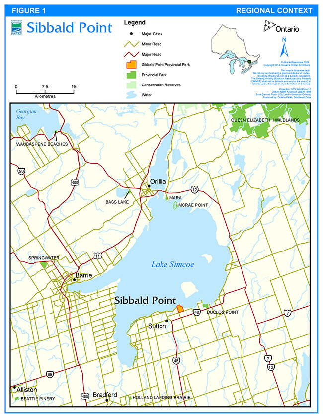
Enlarge Figure 1: Regional context
Figure 2: Park boundary
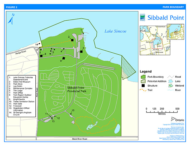
Enlarge Figure 2: Park boundary
Sibbald Point Provincial Park is managed according to the purpose, principles and objectives of the PPCRA and related provincial policies (available on the internet at (/environment-and-energy/provincial-parks-and-conservation-reserves-planning).
3. Park classification
Through park classification, Ontario’s provincial parks are organized into broad categories, each of which has particular purposes and characteristics.
Sibbald Point Provincial Park is managed as a recreational class park. Recreational class parks provide a wide variety of compatible outdoor recreation opportunities in attractive natural surroundings. Sibbald Point Provincial Park is close to several large urban centres and offers a sandy beach, both sunny and shaded campsites, large grassy picnic areas and a forested hiking trail. The recreational classification has been assigned to the park in recognition of the variety and quality of recreation opportunities it provides and its vicinity to population centres in central and southern Ontario.
4. Purpose
The purpose of Sibbald Point Provincial Park is to provide opportunities for a variety of outdoor recreation activities while protecting and fostering an appreciation of the natural and cultural heritage values of the park.
5. Objectives
5.1 Protection objective
Ontario’s protected areas play an important role in representing and conserving the diversity of Ontario’s natural features and ecosystems across the broader landscape. Protected areas include representative examples of life and earth science features and cultural heritage resources within ecologically or geologically defined regions. Ontario’s ecological land classification system provides the basis for the life science feature assessment, and the geological themes provide the basis for earth science assessment.
The park’s protection objectives are to:
- Protect significant natural features and biodiversity.
- Contribute to the protection of the natural areas and functions of the Lake Simcoe shoreline.
- Protect cultural heritage resources, including key historical features and themes of the Sibbald Estate.
5.1.1 Life sciences
Sibbald Point Provincial Park is located on the shores of Lake Simcoe, in Ecodistrict 6E-6. This ecodistrict is characterized by a series of sand and till islands bordered by shore cliffs, beaches, dunes, and terraces. The park is a small island of habitat in a densely settled agricultural and residential landscape. While much of the site is relatively disturbed with large mown areas, compacted soils, and the presence of relatively high numbers of alien and invasive species, the forest types in the natural environment zones are of good quality and there is good potential for improvements to existing habitat (OMNR 2006a).
To date, 415 vascular plants have been identified in the park. Of these, 126 are not native to Ontario and 50 are considered invasive. The only vascular plant species at risk found to date in the park is butternut (Juglans cinerea), which is listed as an endangered species on the Species at Risk in Ontario list. Most of the terrestrial ecosystem types are a complex of deciduous, mixed and coniferous forest types dominated by sugar maple (Acer saccharum L.), American beech (Fagus grandifolia), red oak (Quercus rubra L.), white oak (Q. alba L.), eastern hemlock (Tsugacanadensis), and eastern white cedar (Thuja occidentalis). The wetlands and swamp forests are dominated by cattail species (Typha spp.) and silver maple (Acersaccharinum L.) (OMNR 2006a).
One hundred and twenty five bird species (breeding and migrants), 12 amphibians, six reptiles and 19 mammals have been identified in the park to date. There are no known confirmed breeding records for any provincially rare or at risk species of birds in the park; however, two bird species at risk have been recorded in the park during the breeding season: red-headed woodpecker (Melanerpes erythrocephalus ) (Special Concern) and chimney swift (Chaetura pelagica) (Threatened). Monarch butterflies (Danaus plexippus) are a species of special concern that are known to inhabit the park.
An inventory of aquatic species has not been completed for Sibbald Point Provincial Park; however, a fish inventory of Lake Simcoe, released by the Lake Simcoe Fisheries Assessment Unit in 2010, includes 52 permanent resident species of which six are not native. In addition, seven non-permanent resident species and 12 unconfirmed species were noted. Northern pike (Esox lucius) use the ephemeral streams and wetlands in the park for spawning in the spring.
5.1.2 Earth sciences
Sibbald Point Provincial Park is located within the Lake Simcoe Basin. The sedimentary bedrock of the area was deposited during the Middle Ordovician Period of the Paleozoic Era, making it approximately 460 million years old. The area in and around the park is underlain by sedimentary rock belonging to the Lindsay Formation (Johnson et al. 1992) of the Simcoe Group, which consists of very fine crystalline limestone interbedded with shale.
The physiographic features of the area include a large sand plain, beaches and shore cliffs associated with Lake Simcoe, as well as a small drumlin field that stretches to the southeast of the park. A single small drumlin from this field is located within the park (Chapman and Putnam 1984).
The soils in Sibbald Point Provincial Park consist largely of loams and sandy loams derived from calcareous parent materials. The soils underlying the wetlands in the north central part of the park are well-decomposed organic mucks (Hoffman and Richards, 1955).
5.1.3 Cultural Heritage Resources
The park encompasses the original site of the Sibbald Family Estate, which was established in 1835.
A number of original structures remain from the estate. The most significant of these is the manor house, Eildon Hall, which currently serves as a museum and interpretive centre and contains artefacts once belonging to the Sibbald family. The artefact collection has been held in-trust since 1957 by The Board of Trustees of the Eildon Hall Collection. Additional structures include The Lodge and a log cabin (secondary buildings, which have served a variety of roles over time), and foundations of the barn and outbuildings.
The landscaping reflects that of an English style country estate. At one time, the grounds around the hall were surrounded with a large cedar hedge, imported trees and flowers, a peacock house and a formal carriageway. The estate also included agricultural fields, orchards, a gatehouse and docks (OMNR 2001). Many of these historical landscape features continue to be maintained by Ontario Parks.
An integral part of the Sibbald family history, St. George’s Anglican Church is located at the northwest corner of the park just outside the park boundary. The church was erected in 1877 as a memorial to Susan Sibbald by her sons. Its graveyard includes the Sibbald family plot. The church and graveyard are not located inside the park boundary, and are, therefore, not subject to the policies and regulations of Ontario Parks.
5.2 Recreation objective
The park’s recreation objectives are to:
- Provide high quality outdoor recreation opportunities for visitors, with day-use and camping facilities that showcase the area’s prime recreational resources.
- Provide outdoor skills development opportunities for park visitors that increase the accessibility of the provincial park experience for a diversity of users.
5.3 Heritage appreciation objective
The park’s heritage appreciation objectives are to:
- Foster a knowledge and appreciation of the natural and cultural heritage of the park, and specifically to interpret the history of the Sibbald Estate.
- Interpret and showcase the natural and cultural heritage of Lake Simcoe and its watershed.
- Foster opportunities for outdoor skills development for new and established visitors to Ontario Parks.
5.4 Scientific research objective
The park’s scientific research objective is to:
- Foster scientific research, inventories and monitoring related to the ecological and cultural heritage features of Sibbald Point Provincial Park. This information will help to support planning and management decisions intended to ensure the ecological sustainability of the park.
6. Boundary
Sibbald Point Provincial Park was regulated in 1957. In 1982, a 26 ha portion of the bed of Lake Simcoe was added to the park. The park is composed of: Lots 7 and 8, Concession VIII; Lot 8, Concession IX; part of Lot 9, Concession VIII; part of Lot 7, Concession IX; and the road allowance between Concession VIII and IX in front of Lots 7 and 8, in the Township of Georgina, York Region.
The north boundary of the park will be amended to be delineated along a specific line vector (instead of a set distance from shore) to ensure a permanent, identifiable location on the lakebed, and to provide clarity with respect to the limits of the regulated area. Currently, this boundary is defined as being a set distance from the shore (152.4 m from the water’s edge). The recommended vectored boundary is illustrated in Figure 2.
A 0.95 ha parcel of Crown land, comprising three lots to the east of the park along the Lake Simcoe shoreline, will be added to the park. An additional approximate 5.3 ha of the lakebed extending out a vectored distance from the shoreline will also be regulated, in keeping with the existing park boundary (Figure 2). The addition will be zoned natural environment in accordance with adjacent lands (sections 8.2.1 and 8.2.3), and managed in such a way as to ensure that protection of natural heritage values is the first priority. No development will be permitted.
Park management plan policies apply only to the area within the regulated boundary of the park. Within the park boundary, the protection of park values and features will be achieved through appropriate zoning, the management of land use and activities, education, and monitoring of ecological impacts.
7. Adjacent land uses
Sibbald Point Provincial Park is largely surrounded by private lands. The western and southern limits of the park are bound by Park Road and Black River Road, which are both paved arterial roads. Beyond these roads are residential subdivisions and semi-forested abandoned agricultural lands characteristic of the area. The northern boundary is Lake Simcoe, which is popular for boating in summer and for travel by motorized snow vehicle in winter. The property on the eastern boundary is mainly agricultural, with some privately owned cottages.
Sibbald Point Provincial Park is located within the planning areas of two provincially directed regional plans: the Lake Simcoe Protection Plan and the Greenbelt Plan. The park is also identified as a component of the Greenlands system in the Town of Georgina Official Plan, and the Greenlands and Forest Resource systems in the York Region Official Plan.
8. Zoning
Lands within Sibbald Point Provincial Park are zoned in accordance with their environmental and cultural values, and their need for protection. Zones differentiate the sensitivity of the natural and cultural values, and the permissible degree of development, recreational uses and management practices.
The zoning categories designated for Sibbald Point Provincial Park (historical, natural environment, and development) are compatible for recreational class parks in accordance with Ontario Provincial Parks: Planning and Management Policies (1992). See Figure 3 for a map of zoning.
Zone sizes stated below are approximate and include recommended additions to the park, where applicable.
8.1 Historical zone
Historical zones encompass the provincially significant cultural resources of a park. They generally focus on a specific site (e.g., human occupation site, building) and that site’s relationship to the surrounding landscape, so they may include a protective buffer around the main feature in the zone. Development is limited to trails, necessary signs, interpretive, educational, research and management facilities, and historical restorations or reconstruction where appropriate.
8.1.1 Sibbald Estate (H1) (8 ha):
Zone H1 includes many of the remaining structures and cultural landscape components of the Sibbald Estate. Features include Eildon Hall, The Lodge and the carriageway. The purpose of this zone is to maintain and enhance the historical authenticity of this area of the park while allowing passive recreational uses (e.g., picnicking) to occur.
Figure 3: Zoning
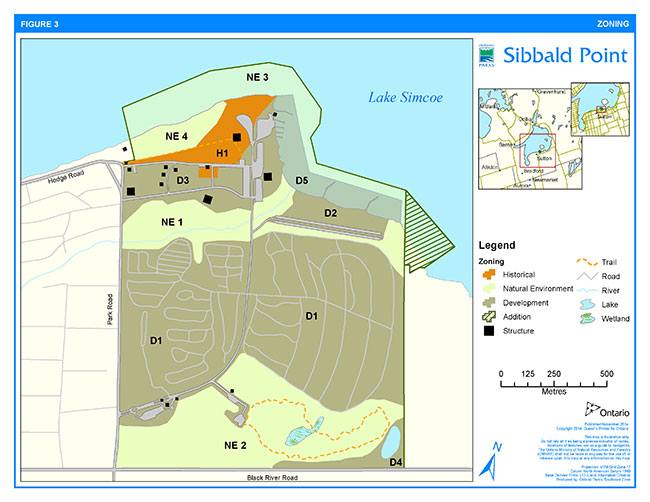
8.2 Natural environment zones
Natural environment zones include natural landscapes which permit the minimum level of development required to support low-intensity recreational activities. Development is limited to trails, necessary signs, minimal interpretive facilities and facilities required to support existing recreational and shoreline protection functions.
8.2.1 Sibbald Creek and Riparian Buffer (NE1) (18 ha):
Zone NE1 extends east-west through the northern section of the park. It includes the forested riparian area along Sibbald Creek to where it empties into Lake Simcoe, as well as the narrow band of woodland, which includes a small stream and acts as a buffer between the campground and beach areas.
8.2.2 Southern Forested Area (NE2) (41 ha):
Zone NE2 covers much of the largely undeveloped southern portion of the park. The area is largely forested and includes the Maidenhair Fern Trail.
8.2.3 Lake Simcoe Lakebed (NE3) (19 ha):
Zone NE3 includes much of the bed of Lake Simcoe located within the park boundary. The boat launch and buoyed swimming area are excluded from this zone.
8.2.4 Shore Bluff (NE4) (5 ha):
Zone NE4 includes the shore bluff along the western portion of the Lake Simcoe shoreline that is within the park, and the mature cedar grove located behind the bluff.
8.3 Development zones
Development zones contain the areas of the park that are geared towards the support of intensive day-use and car camping activities. Development may include roads, visitor control structures, beaches, picnic areas, car campgrounds, commercial service facilities, maintenance facilities, park office and orientation, and interpretive, educational, research and management facilities.
8.3.1 Campground (D1) (98 ha):
Zone D1 consists of the campground area, and includes the campsites, comfort stations, parking and roads.
8.3.2 Beach (D2) (6 ha):
Zone D2 encompasses the beach and day-use areas, and contains facilities to support intensive day-use, including parking, comfort stations and picnic areas.
8.3.3 Administration & Boat Launch (D3) (17 ha):
Zone D3 includes the park office, park store, maintenance yard, boat launch, the Lake Simcoe Fisheries Assessment Unit, and associated parking.
8.3.4 Water Stabilization Pond (D4) (5 ha):
Zone D4 includes the water stabilization pond and a small buffer on the adjacent NE zone. The zone extends west along the fence line at the southern edge of the park, to encompass the spray field and underground irrigation system for the pond.
8.3.5 Waterfront Recreation Area (D5) (8 ha):
Zone D5 includes the area of the lake bed that is used to support intensive recreational activities, and extends from the water’s edge into Lake Simcoe approximately 100 m. This zone includes the buoyed swimming area, the groynes and the boat launch and docking area.
9. Park policies
This section provides site specific management policies and associated actions required to effectively manage Sibbald Point Provincial Park in accordance with applicable legislation and provincial policies. Policies may be adjusted if previously unknown natural heritage values or cultural heritage resources may be impacted by the approved uses.
9.1 Industrial uses
Industrial activities are prohibited in Sibbald Point Provincial Park.
9.2 Commercial uses
The PPCRA allows the MNRF to enter into commercial agreements with respect to the use and occupation of land in provincial parks. Provincial park policies govern what type of commercial activities may be considered in certain classes of parks and zones within a park.
9.2.1 Commercial trapping
Commercial trapping is not permitted in the park.
9.2.2 Commercial fishing and baitfish harvesting
Commercial fishing and baitfish harvesting may occur on Lake Simcoe. These activities do not occur within the park and new operations within the park are not permitted.
9.3 Resource management policies
MNRF will consider adaptive management approaches when managing park resources. Resource management initiatives may also be accomplished through partnerships.
The Lake Simcoe Protection Plan and the Greenbelt Plan were considered in the planning process and policies have been applied where appropriate.
9.3.1 Pesticide use
Pesticides may be used to protect park values in accordance with Ministry of the Environment and Climate Change (MOECC) regulations and MNRF guidelines.
9.3.2 Land management
Landforms within the park will be managed for maintenance of natural processes and function, protection of significant natural and recreational features, and visitor safety.
Management of shoreline erosion and deposition, particularly in the day-use area of the park, is an on-going challenge. The effects of natural shoreline processes are complicated by disturbance related to visitor use, infrastructure such as docks and maintained beaches, and the highly exposed nature of the shoreline. Shoreline management measures may be undertaken (e.g., erosion control, shoreline stabilization). A shoreline geomorphological study may be conducted to identify the cause, effects, and possible solutions to shoreline management issues. Opportunities for restoring ecological processes, and fish and wildlife habitat will be considered in the development and evaluation of options.
Options for beach stabilization, build-up and extension may be explored. Two existing groynes (low walls that extend from shore to prevent shoreline erosion) will be maintained and upgraded as required. A third groyne or similar structure, or combination of structures, may be constructed for additional shoreline and beach stabilization.
The dry beach area (i.e., above the high water mark) will be maintained for recreational use, and replenished with sand as needed. The addition of sand will be in compliance with the federal Fisheries Act and other relevant legislation and policy, and will be limited to areas above the high water mark.
All aggregates needed for in-park use will be acquired from outside the park.
A review may be undertaken of pedestrian, bicycle and vehicular circulation through the park, to ensure safe and efficient movement between destinations . Similarly, a review of user distribution across key recreational facilities may be undertaken to ensure effective use of available resources. Measures such as development of cycling and pedestrian trails, establishing bike lanes along the park road, developing connector trails, and establishing bike parking and/or relocating facilities will be implemented wherever possible to improve user distribution and movement, minimize environmental impacts, and reduce conflicts between modes of transportation.
9.3.2.1 Shore bluff
Accelerated erosion is occurring on the Lake Simcoe shore bluff along the western shoreline of the park. While shoreline erosion is a natural process, uncontrolled access and over-use of the shore bluff area have resulted in the formation of deep gullies and washouts, which in turn have contributed to undercutting, slumping and slope failure. Both the natural shoreline habitat and the adjacent mature cedar grove are being negatively affected.
Uncontrolled public use of the shore bluffs and adjacent woodland will be discouraged through use of tools such as signage, fencing and enforcement. Formalization of a single trail and access to the waterfront may be pursued. Methods that direct traffic flow and public use away from the area will be implemented wherever possible. Specifically, consideration will be given to the closure and re-routing of trails, as well as relocation or removal of park facilities that may contribute to excessive or inappropriate use of the area.
Maintenance and operations activities that allow for the re-establishment of native understory vegetation, such as modified mowing regimes and the planting of native species, or other appropriate activities, may be implemented. A strategy was prepared for the protection of the shore bluff (Marnoch 2007), which contains a number of recommendations that may be implemented in whole or in part.
9.3.2.2 Additions to the park
Ontario Parks supports in principle the acquisition of property for the purposes of addition to the park, if acquisition will enhance the values of the park. If any lands, nearby or adjacent to the park become available for acquisition, they will be evaluated with regard to their contribution to park objectives, willing seller/willing buyer and other factors including available funding.
9.3.3 Water management
Water management refers to water quality and quantity of both natural and constructed water systems.
Lake Simcoe is part of the Trent-Severn Waterway, a series of interconnected waterways, canals and locks, stretching for 386 km through southern and central Ontario connecting Lake Ontario and Georgian Bay. Water levels and flows throughout the waterway are managed by Parks Canada, an agency of Environment Canada.
Water management where it affects shoreline erosion and deposition, aquatic and riparian habitat, recreational use and regular park operations will be considered as part of the geomorphological study proposed in section 9.3.2.
Ontario Parks will conduct monitoring to determine if the removal of a dock in 2009 from the west end of the swimming beach is resulting in significant erosion. If this is the case, options to reduce erosion such as construction of a new dock or erosion management structure may be considered and implemented.
Ontario Parks may dredge the lakebed in the boat launch area to maintain recreational boating access. Dredging will be planned and implemented in accordance with the Department of Fisheries and Oceans' operational statement for routine maintenance dredging and in compliance with the federal Fisheries Act and other relevant legislation and policy.
Ontario Parks may remove or replace two small mooring docks to the south of the boat launch. These docks are currently underused and may no longer be required for recreational purposes. The boat launch may be repaired or replaced, as required.
Options may be explored to improve water flow and fish habitat at the base of the northernmost groyne, adjacent to the Lake Simcoe Fisheries Unit. The structure has restricted the movement of water across the shoreline at this location, resulting in stagnation and sediment deposition.
Water quality, quantity and flow levels of Sibbald Creek, which transects the park, will be formally or informally maintained, as appropriate, and monitored for change due to adjacent development, land use changes and regular operations such as flushing of the municipal water supply pipes. Dialogue will be maintained with the municipality, where appropriate, with regard to the mitigation of potential negative effects. The mouth of the creek may be cleared of sedimentation or dredged, as required, to ensure access for spawning fish and to prevent flooding in the park. Further study of the ecological and hydrological processes of the creek may be undertaken.
The York Region Official Plan was amended in 2005 to allow for the provision of municipal water and sanitary sewer services to the park. Municipal water supply services were installed in 2007 through an agreement with the Town of Georgina. Connection to the municipal sanitary sewer system may be similarly implemented at a later date. The existing water stabilization pond in the southeast corner of the park (Figure 3) has a certificate of approval from the MOECC and will be maintained until such time as it is no longer required for its current purpose. At that time, the pond will be decommissioned and may be rehabilitated for wildlife habitat.
Problems with flooding periodically occur on campsites in low lying areas and areas of poor drainage. Efforts to control flooding campsites will be implemented as necessary.
9.3.4 Alien and Invasive Species
Alien species are plants, animals and micro-organisms that have been unintentionally or deliberately introduced by human activity into areas beyond their normal range. Invasive species are those species whose introduction or spread threatens the environment, the economy and/or society, including human health. Alien species will not be deliberately introduced into the park. Where invasive species threaten natural or cultural values, a control program may be undertaken if feasible and practical.
Active control of selected, high priority alien plant species may be implemented. Several highly invasive species (including, but not limited to: Japanese barberry (Berberis thunbergii), garlic mustard (Alliaria petiolata), dame’s rocket (Hesperismatronalis), moneywort (Lysimachia nummularia), multiflora rose (Rosa multiflora), purple loosestrife (Lythrum salicaria), common buckthorn (Rhamnus cathartica ), Manitoba maple (Acer negundo), European swallow-wort/dog-strangling vine (Cynanchum rossicum), Morrow’s honeysuckle (Loniceramorrowii) and Canada thistle (Cirsium arvense)) have the potential to greatly increase their current distribution and abundance.
9.3.5 Extirpated Native Species
Existing populations of native species may be augmented, and extirpated native species may be reintroduced, if biologically feasible and desirable for perpetuating park values.
9.3.6 Insects and diseases
Infestations of insects and vegetative diseases that are native to the region will normally be allowed to progress naturally. Insect and disease control measures for native and alien species may be considered if the features and/or values of the park are threatened. Infestations by forest insects and diseases may be monitored and assessed.
Emergency measures may be considered to protect the park’s features and values and would be subject to the appropriate MNRF approval.
9.3.7 Fire management
Forest fire management in the park will be in accordance with provincial policies and procedures. Sibbald Point Provincial Park is located outside of the fire region of Ontario, as defined by the Forest Fires Prevention Act.
Outside the fire region, municipalities have the lead in fire protection and management activities (i.e., protecting human lives and properties) under the Fire Protection and Prevention Act and through municipal by-laws. Response for structural fires and forest fires is guided by a municipal fire response agreement between MNRF and the Town of Georgina. Fire evacuation procedures will be as outlined in the Fire Emergency and Evacuation Plan for Sibbald Point Provincial Park. The local fire department is the first emergency responder.
Prescribed burning to achieve ecological or hazard reduction objectives may be considered within Sibbald Point Provincial Park. Plans for any prescribed burning will be developed in accordance with the MNRF Prescribed Burn Manual and other relevant policy, in cooperation with the MNRF Fire Management Program.
Fuel caches are not permitted in the park.
9.3.8 Species at Risk
Species at risk and their habitats will be protected in a manner consistent with the ESA and associated regulations.
Recovery strategies and implementation plans may be prepared in the future by a recovery team for species found in the park (e.g., butternut). Actions identified in any corresponding government response statements, and other actions deemed appropriate by Ontario Parks staff, may be implemented in accordance with Ontario Parks' policies.
9.3.9 Vegetation management
Hazard trees will be removed. Standing dead trees will be felled where they pose a safety risk, otherwise they will be left in place as wildlife habitat. Wind thrown trees will not be removed unless they pose a threat to public safety or interfere with regular park operations. Any reusable material from trees cut for resource management or public safety purposes may be retained for use in the park system or marketed. Movement of any plant materials outside of the park will comply with federal regulations to prevent the spread of invasive species. Other trees and brush cut will be left to deteriorate or may be chipped for use on trails within the park.
Native vegetation may only be pruned where it interferes with authorized recreation activities or recreation facility management (e.g., trail maintenance), to enable approved development, or to ensure public safety. Disturbed areas will be restored with native vegetation where practical and feasible and where it does not conflict with the management of cultural heritage values. Naturalized areas and areas of native vegetation will be given a high priority for protection and will be buffered from development and recreational impacts to the greatest extent possible. Examples of buffering may include an increase in the size of the natural area, strategic planting of native species, fencing or natural barriers, and/or setbacks for development or recreation facilities.
As of September 2010, six butternut trees have been documented within the campground portion of the park. Butternut is listed as endangered because of declines throughout its range due to a disease called butternut canker (Sirococcus clavigignenti-juglandacearum) that inevitably kills the tree over time. Butternut is protected under the ESA, which includes prohibitions against killing, harming or harassing. However, because butternut canker often results in significant deterioration of the tree to the point of becoming hazardous, the ESA has an exemption to allow "non-retainable" trees to be removed. To be eligible for this exemption, each tree must be assessed by a designated Butternut Health Assessor.
Butternut trees that appear to have some resistance to butternut canker may be used as seed sources or for study to assist in the recovery of the species. Only in the instance when a particular tree deteriorates to the point of becoming hazardous, and is located in an area frequented by park visitors, will the tree be considered for removal. Butternut trees in the park may be assessed from time to time to determine individual status and the health of the overall population.
Alien plant species will be maintained where they are an intentional component of the cultural heritage landscape (e.g., estate gardens). Exceptions will be made for species considered invasive and deemed to pose a threat to native plant or wildlife communities. These will be removed by whatever means practical.
For safety purposes, control or eradication of plants that are poisonous to humans by touch (e.g., poison ivy (Toxicodendron radicans ), giant hogweed (Heracleum mantegazzianum)) may be undertaken. Where control is required, it will be directed as closely as possible to the specific problem plant species in locations where conflict is an identified concern (e.g., adjacent to campsites, the beach, or trails).
A minimum 15 m riparian buffer will be maintained along both sides of Sibbald Creek between Lake Simcoe and the beach parking area. A natural buffer between the beach and parking areas will also be maintained. Wherever possible, these natural buffers will be increased to a width of 30 m or more, in keeping with policies identified in the Lake Simcoe Protection Plan. Buffers may be established or enhanced through natural succession or planting of native species.
Native plant species may be planted for the purpose of trail or campsite rehabilitation, restoration or enhancement of existing natural areas. Where planting or seeding is necessary, use will be made exclusively of species native to the park and/or surrounding areas. Seeds and plants used in re-vegetation programs will be derived from sources that originate in or as near the park as possible. Tree species will be derived from within the same or adjacent seed zones, and all other species will be derived from the same or adjacent ecodistricts, wherever possible and practical.
9.3.10 Wildlife management
Animal populations or individual problem animals may be controlled when essential to human health and safety, the health of the species, or the values for which the park has been established.
The reduction of overabundant populations, such as white-tailed deer (Odocoileus virginianus), may be undertaken if population numbers exceed the park’s carrying capacity. Ontario Parks will manage overabundant populations in the park at a level that represents the best scientific judgment as to what the habitat can sustainably support. If necessary, the population will be reduced as quickly as possible to within carrying capacity, and then maintained as required to keep population numbers stable.
Appropriate methods of population control, including lethal methods, will be undertaken directly by Ontario Parks, or through partnerships under the supervision of Ontario Parks. Where reduction or control is necessary, techniques will be used having minimal effects on the components of the park’s environment.
9.3.11 Fisheries management
Ontario Parks is not responsible for fisheries management in Lake Simcoe. However, efforts will be made wherever feasible to support related objectives when considering development or resource management initiatives within the park.
Lake Simcoe supports a significant winter fishery for lake trout (Salvelinusnamaycush) and lake whitefish (Coregonus clupeaformis), and is a year-round fishing destination for yellow perch (Perca flavescens). This recreational fishery attracts anglers from all over North America, and makes Lake Simcoe the most intensively fished inland lake in Ontario (OMOE 2009). Fisheries management will be consistent with fish community objectives under The Lake Simcoe Protection Act and Lake Simcoe Protection Plan. Lake Simcoe is a natural lake trout lake (OMNR 2006b) and management efforts will continue to be made to restore its natural lake trout population. 'Natural' lake trout lakes have been defined to include those lakes that may have lost their self-sustaining native populations, but that have potential for rehabilitation (OMNR 2006b).
The Lake Simcoe Fisheries Assessment Unit (LSFAU), part of the MNRF Science and Research Branch’s Southern Biodiversity and Monitoring Unit, is located in Sibbald Point Provincial Park. The unit monitors fish populations primarily through netting and angler surveys and has continuous data for some programs since the early 1950s. Data collected by the LSFAU are used by MNRF managers in Aurora and Midhurst districts to assist in making management decisions for the lake, and in some cases this information has been used in managing fisheries across the province.
9.3.12 Cultural resources management
The management of cultural heritage resources at Sibbald Point Provincial Park will be directed towards protection, heritage appreciation and research. Cultural heritage resources that may be impacted by any park projects or activities will be identified and managed (i.e., protected, maintained, used and/or disposed of) in accordance with the protected areas mandate (i.e., legislation and policies) and the evaluation process developed by MNRF consistent with the Standards and Guidelines for Conservation of Provincial Heritage Properties (Ontario Heritage Act, Part III.1).
A Cultural Resources Management Strategy (2001) was prepared for the park. The strategy identifies and evaluates the known cultural resources of the park, most of which are related to the Sibbald family estate. The strategy makes recommendations regarding appropriate management of these resources, and establishes preservation and interpretation priorities. A stage one and pre-assessment archaeological and heritage impact report was completed in 2007, and also contains recommendations in regard to the management of the park’s cultural resources. Recommendations from these reports may be implemented.
Advice may be sought from a professional landscaper or horticulturalist to identify priority heritage landscape and vegetation features for protection, and to determine long term management goals and requirements. Recommendations may be implemented.
Eildon Hall and The Lodge will be maintained and renovated as resources allow. Options for the management of the Log Cabin will be further explored and may include stabilizing, renovating or demolishing the structure. Consideration may also be given to donating and relocating the building to a local or other heritage organization, if interest is expressed and concerns and interests are mitigated. Any changes to these structures will be subject to inventory for species at risk or other significant wildlife.
Where a project involves ground disturbance in an area with high archaeological potential, the project will be considered for impacts to archaeological resources. Impacts may include any form of soil disturbance or alteration including testing, excavating, grading, capping and filling. Any identification and evaluation of archaeological resources will be in accordance with the processes documented in the Standards and Guidelines for Consultant Archaeologists (OMTC 2011).
Where a project may impact cultural heritage structures or landscapes, the impacts will be evaluated and appropriate mitigation measures will be implemented. Advice may be sought from a qualified Heritage Restoration Architect.
9.3.13 Research
MNRF encourages scientific research by qualified individuals contributing to the knowledge of natural and cultural heritage and to environmental management. Proposed research is reviewed to ensure adequate consideration of potential impacts on protected area resources, features, staff and visitors.
Research activities require authorization issued under the PPCRA, consistent with relevant policies. Research must meet all requirements under applicable provincial and federal legislation, and may require additional permits or approval (e.g., MNRF Wildlife Scientific Collector authorization or ESA permits).
Ontario Parks may allow temporary facilities in support of approved research and monitoring activities. Sites altered by research activities must be rehabilitated as closely to their previous condition as possible, except where the specific intent of the research activities is disturbance for the purpose of ecological enhancement or restoration.
Priority research projects include:
- collect seed for the genetic analysis of resistance to butternut canker
- determine impacts of recent increases in Canada goose (Branta canadensis) populations on ecology and recreation opportunities in the park
- conduct genetic analysis of the 'blue-spotted-type' salamander found in the park to determine whether they are Jefferson salamanders (Ambystoma jeffersonianum)
- complete archaeological assessment of the park
9.3.14 Inventory and monitoring
Ontario Parks will ensure that planning and management decisions are made with the best available information. Where this information is lacking, Ontario Parks will conduct inventories and monitoring, as necessary, to provide this information.
Such efforts will be undertaken based on established methodologies and best practices.
Inventory and monitoring will foster an adaptive management approach to protected areas management.
Priority monitoring projects include:
- monitor shoreline erosion and deposition along the shore bluff and in the beach and boat launch areas
- monitor flow and siltation levels in Sibbald Creek
- monitor campsites and trails for erosion and degradation
- continued monitoring of butternut population
- monitoring of invasive species (baseline information is needed for glossy buckthorn (Rhamnus frangula), European swallow-wort/dog strangling vine (Vincetoxicum rossicum) and others)
- determine current numbers, trends, breeding status and distribution of red-headed woodpecker
- conduct a detailed inventory to determine the identity and relative abundance of all bat species present in the park
- monitor restoration initiatives and success of plantings
- inventory insect populations
9.4 Recreation management policies
Recreation management policies protect significant natural and cultural heritage features while allowing opportunities for compatible outdoor recreation. Recreation facilities include campgrounds, trails, picnic areas and shelters, beach and swimming areas, a boat launch, docks and playground equipment.
Modifications to existing trail and road systems that improve the movement of pedestrians, bicycles and vehicles through the park will be considered and implemented wherever possible. These may include bicycle lanes on existing roadways, formalized walking trails to connect facilities, redirection of visitor use away from sensitive features, and initiatives that result in better access to and distribution across existing recreational facilities (e.g., beach area).
Existing recreation facilities will be maintained and improved as required, with exceptions identified below. New or expanded recreational uses or services will be assessed on a case by case basis to ensure compatibility with the overall park direction.
9.4.1 Day-use areas
The day-use area consists of the beach, boat launch and picnic areas.
Day-use capacity will be maintained at a maximum of 1800 vehicles. The park may be closed to further day-use visitors once the vehicle capacity of the parking areas is reached, or at the discretion of the park superintendent .
9.4.2 Winter use
Winter recreational use will be limited to self -use, non-motorized activities such as walking, snowshoeing and cross-country skiing. Park services and facilities (e.g., washrooms, warm up areas, and trail grooming) are not currently provided. Winter camping is not currently permitted.
Formalized winter operations, including winter camping, may be considered if demand warrants and resources allow.
9.4.3 Access
The primary public access point will be through the gatehouse at Park Road. During the non-operating season, public vehicle access will be limited to the main park road between the gatehouse and the boat launch area. Off-season vehicular access may be restricted or eliminated for safety purposes or if damage to park infrastructure warrants. Should this occur, parking will be provided at the main park entrance near the gatehouse.
9.4.4 Services for visitors
A food concession, park store, firewood, picnic shelter rentals, and equipment rentals will all continue to be offered based on demand and available resources. Additional services may be considered if demand warrants and resources permit.
9.4.5 Fees
Fees are collected in accordance with the fee schedule set by Ontario Parks for overnight and day-use access to the park and facilities.
9.4.6 Hunting
Recreational hunting is prohibited.
9.4.7 Recreational fishing
Lake Simcoe is a popular recreational fishing destination. Recreational fishing is subject to provincial and federal fisheries regulations (e.g., the Fish and Wildlife Conservation Act and the Fisheries Act (Canada)) as set out in the Ontario Recreational Fishing Regulations Summary.
Fishing is permitted from the shoreline in designated areas only.
9.4.8 Trails
The Maidenhair Fern Trail will continue to function as a self-guided interpretive hiking trail, and the primary hiking opportunity in the park. This trail may be extended or improved.
Bicycle lanes may be developed in coordination with road work or where the opportunity arises. A pedestrian and/or cycling trail may be developed along the main roadway between the beach area and the entrance to the campground areas.
A network of informal trails has developed, which links the day-use area with the campgrounds. This network may be formalized and individual trails closed or upgraded as required. Campers will be encouraged to park on their campsites or in campground parking lots and use these trails to reach the day-use area in order to alleviate demand for day-use parking spaces.
Existing trails (including informal trails) may be formalized, rerouted, closed, or upgraded.
9.4.9 Mechanized travel
Aircraft landings are not permitted in the park.
Motorized snow vehicles, ATVs and off-road vehicles are prohibited in the park, except to provide winter access onto Lake Simcoe. Winter access will be limited to the designated route along the main park road from the park entrance to the boat launch. The park superintendent may prohibit the use of such vehicles should this use cease to be compatible with changing winter use of the park, or to prevent degradation of or damage to park values.
Motorized snow vehicles and ATVs may be used by park staff for maintenance or operations when necessary.
No overnight boat-in mooring facilities will be provided. Boats are not permitted to tie to the park shoreline.
9.4.10 Other recreational uses
Physical geocaching is not permitted. Virtual geocaching may be permitted with approval from the park superintendent, in accordance with Ontario Parks policy, where impacts to natural and cultural heritage features are not anticipated.
There are emerging recreational uses for which no current or limited management policy exists. The park superintendent will use legislation, park policy and guidelines that are in place to manage emerging uses in an interim capacity. Long-term management direction will be determined through a subsequent planning process.
9.4.11 York Region Outdoor Education Centre
The York Region Outdoor Education Centre is located within the park boundary. The facility is operated by the York Region District School Board (YRDSB) for the benefit of students in the York Region. It will continue to operate according to the terms and conditions specified in the lease agreement between the YRDSB and Ontario Parks. The original agreement was signed June 2004 and covered a period of ten years. As of 2014, the renewed agreement will be reviewed every five years for extension or renewal, with the consent of both parties.
The facility occupies a site between the maintenance yard and park office. It is used by the school board to conduct outdoor education programs for elementary students throughout the school year. The YRDSB is responsible for all operating and capital costs related to the centre.
Improvements to, or replacement of, the existing building and structures may be implemented. Initiatives to 'green' the facilities may be pursued. Opportunities to connect to the park water supply and/or sewage system may also be pursued. Any changes or improvements to the facility will be in keeping with the Class EA-PPCR.
9.5 Operations policies
A park operating plan will provide park staff with the direction required to operate the park on a day to day basis. In addition to addressing the operations policies identified here, the plan will include such topics as budget, staffing, maintenance schedules, enforcement, and emergency services.
The provisions of the plan will be consistent with the approved Ontario Provincial Parks Minimum Operating Standards, and will be reviewed and updated as required.
9.5.1 Education
Provincial parks have a role in supporting the education objective in the PPCRA. The manner in which that objective is met will vary for each park and may be adapted based on the park’s resources and the MNRF's direction and priorities at the time. For further direction on park education and programming, refer to the strategic direction for education in Ontario Parks and additional park specific education plans.
An education plan has been developed for the park and may be updated as required.
9.5.1.1 Information
Information will be provided to park visitors in various forms, which may include: direct contact with park staff, activities, displays and tours at the Eildon Hall museum, information kiosks, signage, the Ontario Parks website and an annually published park tabloid.
Information provided to park visitors may:
- inform about the park services, facilities and management
- inform about recreation and interpretive opportunities
- promote other area attractions
- inform about the programs and functions of the MNRF
- instil a sense of respect for the park environment
- provide a means of feedback for visitors to communicate to the MNRF
- inform about the natural heritage values and cultural heritage resources of the park and area
- inform about the threat of invasive species and how to prevent their introduction and spread
9.5.1.2 Park interpretation
During the operating season, the park’s education program delivers a variety of interpretive activities. These may be presented in evening programs, at the park amphitheatre, on-site during special events and at strategic locations throughout the park. Volunteer involvement will be encouraged in some projects. Self-guided interpretive opportunities, such as walking tours of the Maidenhair Fern Trail, will also be promoted.
The following is a list of key interpretive themes for Sibbald Point Provincial Park:
- life science resources – flora and fauna
- earth science resources – shoreline and farming community
- heritage resources – Sibbald Family history
- outdoor recreation skills
- the natural and cultural heritage of Lake Simcoe and its watershed
9.5.1.3 Outdoor recreation programs
The provision of self-directed recreation opportunities, such as boating, swimming and hiking will be emphasized. Winter use of the park is also encouraged for cross-country skiing, snowshoeing or walking on a self-use basis. Learn to camp programs and other programs that introduce outdoor recreation skills to new park users may be offered.
9.5.2 Partnerships
In the implementation of the park management plan, Ontario Parks may pursue opportunities for partnerships involving other agencies and groups through formal partnership agreements. Partners may represent the local community, and local and provincial interests. Partners will work with Ontario Parks to assist in the implementation of the management plan and will follow provincial park policies and regulations.
9.6 Marketing and communications policies
9.6.1 Marketing
Sibbald Point Provincial Park will be promoted in accordance with Ontario Parks' marketing plan, including through the Ontario Parks website, parks guide and park tabloid.
9.6.2 Communications
Information about the park will be made available to the public through a variety of means, which may include the Ontario Parks website, the park tabloid, the Eildon Hall museum and the Ontario Parks Guide.
9.7 Development policies
All development undertaken by Ontario Parks or by partners on its behalf will comply with the Class EA-PPCR, and will be carried out in accordance with approved site and development plans that meet standards for provincial parks.
Areas proposed for development will require prior assessment for cultural heritage resources (see Section 9.3.12) and significant natural heritage values, such as species at risk, to ensure these values are identified and protected at the site.
New development will be located in such a way as to minimize the effects of the one in 100 year flood elevation of Lake Simcoe.
9.7.1 Parking areas
Parking will be maintained at current capacity for vehicle numbers. Design improvements and facility upgrades may be implemented to improve access, use or safety, minimize ecological impacts or extend the life of the facility.
9.7.2 Day-use areas
Improvements to existing day-use facilities will be considered where demand and resources warrant. A picnic shelter and comfort station located in the natural environment zone near the shore bluffs are seldom used and may be decommissioned and removed or demolished.
9.7.3 Campgrounds
Campsites and group campsites may be closed where they are consistently underused, pose user conflicts, or result in undue damage to the natural environment. Replacement sites may be developed within the existing campground development areas. The possibility of developing expanded 'family' campsites or campsite clusters within existing campground development areas may be explored. These sites will re-allocate existing facilities, and will not result in an increase in total campsite numbers or campground capacity.
Additional campsites may be electrified.
9.7.4 Alternative or fixed roof accommodations
The development of alternative or fixed roofed accommodations may be considered and implemented. Potential locations will be considered in zone D1.
9.7.5 Maintenance and administrative areas
Maintenance and administrative areas will be maintained and upgraded as required. Park assets, such as the pump house and storage facilities, which are no longer required, may be removed.
The park office may be relocated and/or replaced. Potential locations include the existing site in zone D3, or near the Main Gate house in zone D1. The park store may be relocated closer to the main day-use area in zone D3.
The main entrance may be reconfigured and expanded to allow better traffic flow into the park on busy peak season days. This would involve the relocation of the second entrance lane to the south, and the installation of a kiosk or similar structure between the lanes to facilitate visitor contact.
A visitor centre may be constructed if demand warrants and resources allow. Potential locations include the amphitheatre site and the field that currently houses the baseball diamond, both of which are located in zone D3.
10. Implementation priorities
Park resource management, development and operations proposals will be phased in as resources permit and may include the following:
Phase 1 (short term)
- Implement measures to protect the shore bluff (section 9.3.2.1).
- Manage native, invasive and cultural vegetation in the park (section 9.3.9).
- Maintain and improve natural areas and buffers through plantings and natural succession (section 9.3.9).
- Upgrade or close campsites and group campsites as needed (section 9.7.3).
- Maintain and improve existing trails and trail networks (section 9.4.8).
- Maintain, repair and upgrade park facilities and infrastructure, as needed (e.g., comfort stations, docks, beach, buildings and structures, parking, campsites, roads, etc.) (section 9.7).
- Examine opportunities for alternative roofed accommodations (section 9.7.4).
- Stabilize, renovate or restore, as necessary, Eildon Hall and The Lodge in order to ensure their preservation (section 9.3.12).
- Stabilize the Log Cabin until decisions are made to restore or demolish the structure (section 9.3.12).
Phase 2 (medium term)
- Conduct review of pedestrian, cycling and vehicular circulation and implement recommendations, as appropriate (section 9.3.2).
- Develop bike lane and pedestrian trail along the main roadway between the beach area and campground roads (section 9.4.8).
- Identify, assess and manage the park’s known and potential cultural heritage resources (section 9.3.12).
- Conduct a shoreline geomorphological study (section 9.3.2).
Phase 3 (long term)
- Relocate and/or replace park store (section 9.7.5).
- Relocate and/or replace park office (section 9.7.5).
- Develop visitor centre (section 9.7.5).
- Install municipal sewer services (section 9.3.3).
11. Examination and adjustment
This management plan will be examined after it has been in place for 20 years to determine whether the management direction is still relevant, effective and current, or if an adjustment is required. In circumstances where this plan is not providing sufficient direction, it can be examined prior to the next scheduled examination.
External requests for adjustments and to address specific concerns may be considered. Ontario Parks can provide further guidance to external parties on the process for requesting an adjustment to this statement and whether specific requests can/will be considered.
12. Key references
Chapman, L.J. and D.F. Putnam. 1984. The Physiography of Southern Ontario. Ontario Geological Survey, Special Volume 2. Map P.2715 (coloured), scale 1: 600 000.
Hoffman, D.W. and N.R. Richards. 1955. Soil Survey of York County. (Ontario Soil Survey Report No. 19).
Johnson, M.D., D.K. Armstrong, B.V. Sanford, P.G. Telford, and M.A. Rutka. 1992. Paleozoic and Mesozoic Geology of Ontario; in Geology of Ontario, Ontario Geological Survey, Special Volume 4, Part 2, p.907-1008.
Ontario Ministry of the Environment (OMOE). 2009. Lake Simcoe Protection Plan. Queen’s Printer for Ontario.
Ontario Ministry of Municipal Affairs and Housing (OMMAH). 2005. Greenbelt Plan. Queen’s Printer for Ontario.
Ontario Minister of Natural Resources (OMNR). 1992. Ontario Provincial Parks: Planningand Management Policies. Queen’s Printer for Ontario.
OMNR. 1994. Ontario Provincial Parks Management Planning Manual. Queen’s Printer for Ontario.
OMNR. 1997. Ontario Parks' Research and Information Strategy. Queen’s Printer for Ontario.
OMNR. 1999. Natural Heritage Education Plan, Sibbald Point Provincial Park. Ontario Parks.
OMNR. 2001. Sibbald Point Provincial Park Cultural Resources Management Strategy, prepared by S. Yuill.
OMNR. 2003. A Fish Species List for Lake Simcoe, prepared by F. etter. 2003. Queen’s Printer for Ontario. (Lake Simcoe Fisheries Assessment Unit Update No. 2003-4).
OMNR. 2004a. Ontario Hunting Regulations Summary 2004. Queen’s Printer for Ontario.
OMNR. 2004b. Research and Information Strategy, Ontario Parks, Central Zone (2004-2009), prepared by J.B. Korol. Huntsville, ON: OMNR, Central Zone, Ontario Parks.
OMNR. 2005a. A Class Environmental Assessment for Provincial Parks andConservation Reserves. Queen’s Printer for Ontario.
OMNR. 2005b. Ontario Recreational Fishing Regulations Summary 2005-2006. Queen’s Printer for Ontario.
OMNR. 2006a. A Detailed Life Science Inventory of Sibbald Point Provincial Park, prepared by J.B. Korol. Huntsville, ON: OMNR, Central Zone, Ontario Parks.
OMNR. 2006b. Inland Ontario Lakes Designated for Lake Trout Management, Revised April 2006. Peterborough, ON: OMNR Fisheries Section.
OMNR. 2006c. Provincial Parks and Conservation Reserves Act, 2006. Toronto.
OMNR. 2006d. Technical Guideline for Cultural Heritage Resources for ProjectsPlanned under the Class Environmental Assessment for MNR Resource Stewardship and Facility Development Projects and the Class Environmental Assessment for Provincial Parks and Conservation Reserves. Queen’s Printer for Ontario.
OMNR. 2007a. An Environmental Protection Plan for the Shore Bluff - Sibbald PointProvincial Park, prepared by G. Marnoch. Huntsville, ON: Central Zone Office, Ontario Parks.
OMNR. 2007b. Ecological Monitoring Strategy, Ontario Parks, Central Zone (2007-2012), prepared by J.B. Korol. Huntsville, ON: OMNR, Central Zone, Ontario Parks.
OMNR. 2011a. Ontario’s Biodiversity Strategy: Renewing our Commitment to Protecting What Sustains Us. Peterborough, ON: Queen’s Printer for Ontario.
OMNR. 2011b. Our Sustainable Future; A Renewed Call to Action, Ministry ofNatural Resources Strategic Directions. Queen’s Printer for Ontario.
OMNRF. 2014. Wildland Fire Management Strategy (draft). Aviation, Forest Fire and Emergency Services Branch.
Ontario Ministry of Tourism and Culture (OMTC). 2010. Standards and Guidelines forConservation of Provincial Heritage Properties. Available online at: http://www.mtc.gov.on.ca/en/heritage/heritage_s_g.shtml
OMTC. 2011. Standards and Guidelines for Consultant Archaeologists. Available online at: http://www.mtc.gov.on.ca/en/archaeology/archaeology_s_g.shtml
Slattery, D.J.G. 2007. Stage One and Pre-assessment Archaeological and Heritage Impact Study of Sibbald Point Provincial Park, Sutton Ontario. North Bay, ON: Horizon Archaeology.
Appendix I: Consultation
Aboriginal and public involvement has been a very important part of the Sibbald Point Provincial Park management planning process. The following is a summary of involvement.
Summary and results of aboriginal involvement
The Chippewas of Georgina Island First Nation were contacted by letter in the fall of 2007, prior to commencement of the planning process. At the release of the terms of reference and background information file, a second letter was sent to the Chippewas of Georgina Island First Nation, along with letters to the Ogemawahj Tribal Council, the Chiefs of Ontario, the Union of Ontario Indians, and the Métis Nation of Ontario with an invitation to participate in the development of the management plan for Sibbald Point Provincial Park.
An invitation to participate and a copy of the preliminary management plan were sent to the Chippewas of Georgina Island First Nation as part of the preliminary management planning stage.
No formal response has been received to date from the community or organizations contacted. Participation is encouraged at any time during the management planning process.
Summary and results of public consultation
Phase 1 – Invitation to Participate; Terms of Reference; Background Information
The Sibbald Point Provincial Park Terms of Reference was approved in November 2007. The Invitation to Participate and Inspect the Approved Terms of Reference and Background Information was released for public review on May 8, 2008. Letters were mailed to persons and organizations on the park planning mandatory contact list, stakeholders and interested persons, and an announcement was made through a newspaper notice in the Georgina Advocate. Bulletins were posted in Sibbald Point Provincial Park and a notice was posted on the Environmental Bill of Rights Environmental Registry. A 46-day period was provided to allow interested individuals and parties to submit comments.
Three comments were received from the public. Comments included recommendations for clear focus on ecological integrity, integration with other planning processes (e.g., the Lake Simcoe Protection Act), opportunities for public participation, review of park classification, and administrative changes.
Additional comments included concerns over the state of repair of park infrastructure, problem use and parking, an interest in providing year round recreational opportunities and associated facilities, and support for connection to the municipal sewage collection system.
Comments have been addressed as follows:
- Ecological integrity has been addressed through proposed policies relating to the protection and expansion of existing natural areas, vegetation and wildlife management, and shoreline protection.
- The need for consideration of regional planning initiatives such as the Lake Simcoe Protection Act and the Greenbelt Plan has been identified.
- Focused consultation has occurred with key stakeholder groups, and further opportunities for consultation will be provided in accordance with the PPRCA, the Class EA-PPCR and other provincial policy.
- The recreational class designation of this provincial park has been deemed to be appropriate, based on the high percentage of the land base dedicated to outdoor recreation, and due to the significance of the park as a recreational destination for a broad public demographic. Zoning has, however, been modified to better reflect the natural heritage values of the north western portion of the park.
- The improvement and renewal of facilities such as parking, docks and buildings, connection to the municipal sewage system, and the improvement of vehicular, bicycle and pedestrian circulation routes may be undertaken.
- The development of year-round recreational opportunities may be pursued in the future should demand and resources warrant.
Phase 2 – Preliminary Management Plan
During this phase of involvement, the public was offered an opportunity to review and comment on the proposed management policies and activities for Sibbald Point Provincial Park. Invitations to participate were mailed to persons and organizations on the park planning mandatory contact list, local landowners, stakeholders and interested individuals. The 45- day review and comment period, July 31 to September 14, 2012, was announced through a newspaper notice in the Georgina Advocate and a posting on the Environmental Bill of Rights (EBR) Environmental Registry. Notices were also posted at Sibbald Point Provincial Park and a public information session was held at the park on August 14, 2012.
Twenty one people attended the public open house. Twenty four comments were received. This included fourteen written comments, four comments received by phone and six comments submitted through the EBR. The majority of comments supported the plan’s zoning changes and park additions. Additional focus and some alternate language regarding the cultural heritage values of the park were also requested.
A number of respondents expressed concern regarding the proposed winter road closure for vehicles. One comment regarding park maintenance and enforcement was also noted.
This management plan considered all submitted comments and incorporated several additional references and specifications to cultural heritage management considerations.
Off-season public vehicle access will continue in the park, but remains subject to public safety and significant damage to park infrastructure (section 9.4.3).
Enforcement concerns were noted and will be acted upon as resources allow.
In response to a comment received outside of the comment period, the plan states that no development will be permitted in the Crown land parcel and associated lake bed that will be added to the park (section 6.0).