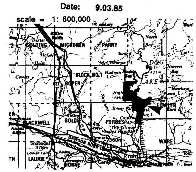
Silver Falls Provincial Park Management Statement
This document provides policy direction for the protection, development and management of Silver Falls Provincial Park and its resources.
Interim Management Statement
Regional Director’s approval statement
Silver Falls Provincial Park
This revised Interim Management Statement will provide interim direction for the management of the above Provincial Park until a comprehensive Park Management Plan is prepared.
This statement will provide the basis for the subsequent preparation of the Park Management Plan.
I am pleased to approve this Interim Management Statement.
Signed by:
M.S. Millar
A/Regional Director
North Central Region
Revised March 1991
Background information
| Name | Silver Falls |
|---|---|
| Class: | Natural Environment |
| M.N.R. District: | Thunder Bay |
| M.N.R. Region: | North Central |
| Total area ha: | 3261 |
| Land: | |
| Water: | |
| Site region: | 4W |
| Site district: | 2 |
| Date in Regulation: | March 9, 1985 |
Life science representation / Targets
| Site type/landscape unit | Species/communities |
|---|---|
| Valley complex: bare bedrock, steep slopes, organic pools. | Associated vegetation communities. Uncommon plants frequent lower Kaministiquia Valley. |
Earth science representation / Targets
| Geological theme | Feature |
|---|---|
| Algonquin Stadial Timiskaming Interstadial |
Late Wisconsin: Dog Lake Moraine - wave-modified moraine; glacial Lake Kaministiquia spillway, lake clays, shore processes. |
Cultural resource representation
| Theme | Theme segment |
|---|---|
| Undefined petroform Post Contact Tribes and Bands Northern Hunters and Fishers Fur Trade; Environmental Frontiersmen |
Kaministiquia dog effigy; also flakes, etc. Native cemetery Selkirk pottety; Archaic stone tools Portage (Dog Lake to Little Dog Lake) |
Recreation opportunities
| Day use | Car camping | Wilderness/back country |
|---|---|---|
| 7445 | 21811 | NII |
Inventories
| Level/type | Reconnaissance/completion date | Detailed completion date | Required? |
|---|---|---|---|
| life science | checksheet | Environmental Inventory | Final Edit |
| earth science | checksheet | Environmental Inventory | Final Edit |
| cultural | site record forms | McLeod,1978;McLeod,1979 | |
| recreational | |||
| other |
Silver Falls Provincial Park Interim Management Statement
I. Land tenure
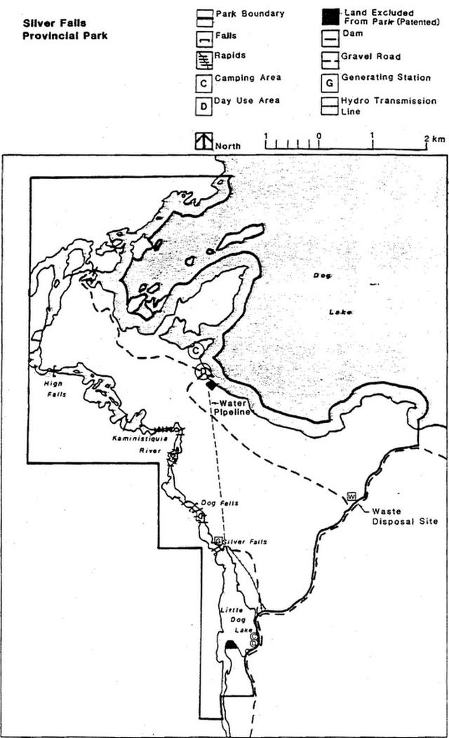
All land within the Park is Crown Land.
There is a 338 hectare Water Power Lease agreement #64 with Ontario Hydro and a Land Use Permit with Ontario Hydro for a transmission line from the generation station to the Park’s south boundary.
Guideline:
Present forms of land tenure with Ontario Hydro will continue including arrangements for maintenance control of lake levels, access, etc.
Further granting of tenure will not be considered for any land within the Park.
II. Land acquisition/disposition
There is no patented land within the Park area.
There are two patented parcels of land which are surrounded by the Park. These are excluded from the Park. (The property owners names and addresses are on file in the Thunder Bay District Office.)
Guideline:
No consideration will be given to acquiring additional land or disposing of land within the Park.
III. Existing/proposed development
Presently, the existing development at Silver Falls Provincial Park includes:
Public Road (no form of land tenure): 9.6 km
Dog Lake Campsites (developed in 1979): 55
Earth Pit Toilets: 8
Boat Launch Ramp: 1
Car Parking Areas (50 Vehicles - Total): 2
Day Use Area: 2 ha
Guideline:
The existing recreation facilities will continue to be made available for public use. These facilities will not be maintained on a regular basis.
Development (excluding that related to public health and safety) will not be undertaken prior to the completion of a Management Plan.
The boundaries for this Park will be surveyed and cut, and appropriate signage provided, if funding permits.
IV. Recreational activities
Silver Falls Provincial Park is classified as a Natural Environment Park.
The 1983 use of the Park was estimated to be 6,500 camper nights (6,000 - Dog, 500 - Little Dog) and 1,500 Day User Days, (1,000 - Dog, 500 - Little Dog).
Sport fishing for Northern Pike occurs to a limited degree on Kaministiquia River between Dog Lake and Little Dog Lake and ice fishing in the immediate area of the Dog Lake campground.
Local residents hunt for deer, moose and grouse in the Park, mainly during October and November.
Guideline:
Existing recreation activities will be permitted to continue. If any unforeseen conflicts develop in the future (e.g., hunting versus camping), necessary restrictions will be implemented.
Wildlife viewing will be permitted.
V. Commercial activities
Approximately 50% of trapline area #172 is located within the Park boundary. A trapline cabin is also located within the boundary in the northwest section of the Park. (The trapline data is on file in the Thunder Bay District Office.)
The Park comprises approximately 40% of Bait Fish Licence area #T.B.-109. (The Bait Fish Licence data is on file in the Thunder Bay District Office.)
No other commercial activities presently exist.
Guideline:
Trapping will be phased out over a 21 year period or when the trapper retires or dies, whichever is sooner. At that time, those portions of the licence within the Park will be removed. Where a trapper’s licence lapses, the licence will not be renewed. No new licences will be issued. The cabin will be allowed to stay in its present location during the 21 year period. No additional cabins or relocation of the existing cabin will be permitted within the Park boundary.
The Park has been withdrawn from staking.
Aggregate extraction will not be permitted except by M.N.R. for Park purposes.
Bait fishing will not be permitted within the Park.
Other commercial activities will not be permitted.
Consideration will be given to allowing private interest groups/individuals to operate/maintain the existing campground and related facilities.
VI. Natural resources
Some natural resource values have been identified to date. However, no major resource management issues have been identified with these features.
Tree plantations are located within the Park.
Guideline:
The tree plantations located between Dog Lake and Little Dog Lake will be managed to enhance Park objectives.
Normal forest fire suppression will take place within the Park area.
Until appropriate measures are identified in a Management Plan, insects and diseases will be controlled as is deemed necessary.
VII. Cultural resources
Several significant archaeological sites have been identified in the Park area.
Detailed maps showing locations of the archaeological sites are on file in the Thunder Bay District Office.
Guideline:
Any disturbance of archaeological sites within the Park will be discouraged, and restrictions on activities on or near the sites will be implemented if necessary.
VIII. Client services
No literature is presently available. Limited signage is available at the Dog Lake campgrounds.
Guideline:
Existing signage will be maintained within the Park.
Additional client services will not be provided until a Management Plan has been completed, except as required by legislation or M.N.R. Policy.
IX. Research and inventories
Earth and life science inventory checksheets have been completed for Silver Falls Provincial Park and are on file in the Thunder Bay District Office.
Guideline:
Additional research inventories will be encouraged to further document Park values. These may be carried out by M.N.R. or by outside interest groups/individuals. Any research must first be approved by the District Manager.
References/sources
Kor, P. 1976. Brief Geology and Geomorphology of Silver Falls Provincial Park Reserve. (Unedited and unpublished document.) Ontario Ministry of Natural Resources, Division of Parks, Environmental Planning Series.
McLeod, M. 1978. The Archaeology of Dog Lake, Thunder Bay: 9,000 Years of Prehistory. Ontario Heritage Foundation.
McLeod, M. 1978. The Archaeology of Dog Lake, Thunder Bay: 9,000 Years of Prehistory. Ontario Heritage Foundation. V.II. Ontario Heritage Foundation.
O.M.N.R. 1983. Backgrounder Land Use Guidelines.
O.M.N.R. 1983. Thunder Bay District Land Use Guidelines.