South Rushbrook Old Pine Provincial Park Management Statement
This document provides policy direction for the protection, development and management of South Rushbrook Old Pine Provincial Park and its resources.
Interim Management Statement
2006
Approval statement
I am pleased to approve this Interim Management Statement for South Rushbrook Old Pine Provincial Park. Ontario’s Living Legacy Land Use Strategy (1999) identified this area as a natural environment class provincial park. This park is not yet regulated.
This Interim Management Statement provides direction for the protection and custodial management of South Rushbrook Old Pine Provincial Park.
Signed by:
Paul Bewick
Zone Manager
Northeast Zone
Ontario Parks
Date: June 12, 2006
1.0 Introduction
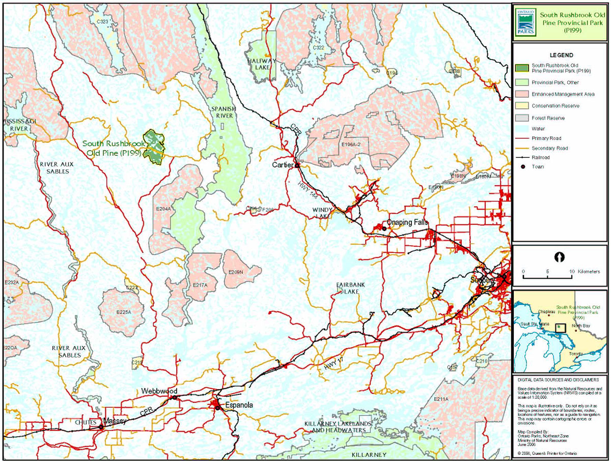
South Rushbrook Old Pine Provincial Park is located within the Sudbury District of the Ministry of Natural Resources (MNR). It is approximately 54 kilometres north of the Town of Espanola and 27 kilometres west of Cartier, in close proximity to the Spanish River Valley Signature Site (Figure 1). The park comprises 2,158 hectares in portions of Oshell, Ouellette, Solski and Rowat townships. It is bounded to the northwest by Shakwa Lake and to the east by Rushbrook Lake. Shakwa Road provides access to and crosses the south-central portion of the park (Figure 2).
South Rushbrook Old Pine Provincial Park is significant for its associations of old growth white and red pine forest communities growing on hilly end moraine deposits. These communities were determined to be the best representation of this landform and vegetation combination in Ecodistrict 4E-3 (Morris 2002).
South Rushbrook Old Pine Provincial Park was designated through Ontario’s Living Legacy Land Use Strategy (OMNR 1999) as a natural environment park. The purpose of the natural environment designation within the context of the provincial park system is to protect high quality recreational and educational experiences in an attractive outdoor setting.
This park has not yet been regulated under the Provincial Parks Act (1990).
1.1 Objectives
South Rushbrook Old Pine Provincial Park will be managed according to provincial park objectives:
Protection: To protect provincially significant elements of the natural and cultural landscapes of Ontario.
Recreation: To provide provincial park outdoor recreation opportunities ranging from high-intensity day-use to low-intensity wilderness experiences.
Heritage Appreciation: To provide opportunities for exploration and appreciation of the outdoor natural and cultural heritage of Ontario.
Tourism: To provide Ontario’s residents and out-of-province visitors with opportunities to discover and experience the distinctive regions of the Province.
2.0 Management context
The purpose of this Interim Management Statement (IMS) is to provide direction to ensure the custodial management of park resources. Future park planning may be undertaken as required to provide direction on significant decisions regarding resource stewardship, development, operations and permitted uses.
Park management will follow direction from:
- Provincial Parks Act and regulations
- Ontario Provincial Parks Planning and Management Policies (OMNR 1992)
- Crown Land Use Policy Atlas (OMNR 2004a)
- Ontario’s Living Legacy Land Use Strategy (OMNR 1999) and policy clarification amendments (OMNR 2000) and related direction
Figure 1: Regional Setting

Enlarge Figure 1: Regional Setting
Figure 2: Park Boundary
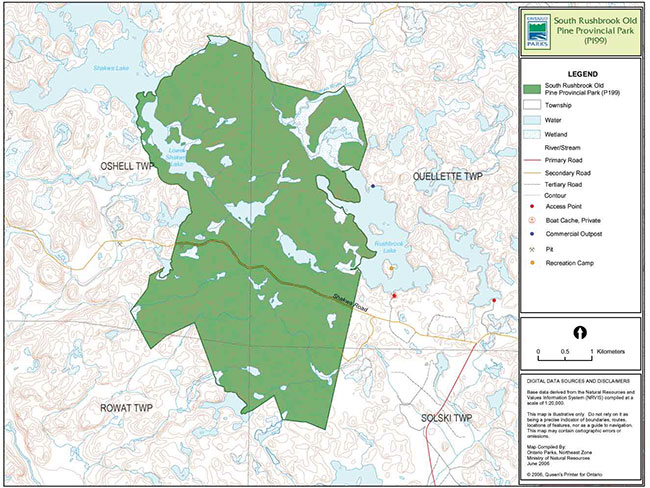
Enlarge Figure 2: Park Boundary
In addressing custodial management obligations to protect park values and ensure public health and safety, Ontario Parks will ensure that policy and Environmental Assessment Act (1990) requirements are implemented.
2.1 Environmental Assessment
As a part of the Ontario Ministry of Natural Resources (MNR), Ontario Parks is a public sector agency that is subject to the Environmental Assessment Act. Park management will be carried out in accordance with legislation, policies and guidelines that are required under MNR's A Class Environmental Assessment for Provincial Parks and Conservation Reserves (OMNR 2005).
3.0 Park features and values
South Rushbrook Old Pine Provincial Park is a natural environment class park located in the Sudbury MNR Administrative District. The park lies near the centre of Ecodistrict 4E-3.
3.1 Geological features
The park is located within the Abitibi Subprovince of the Superior Province in a large area of relatively unstudied granitic rock (the Ramsey-Algoma granitoid complex). This large batholithic complex consists of mainly porphyritic, leucocratic granite or quartz monzonite with subordinate granodiorite. Granitic rock outcrops within the park are small in size (Blackburn 2003).
Quaternary deposits are Holocene (or recent) age morainal material. North of Shakwa Road, bedrock knobs with up to 20% outcrop protrude through moraine cover, with relief on the order of 60 m. South of the road, relief is again moderate but hummocky, and outcrops are scarce. The numerous small lakes south of Shakwa Road differ from those to the north in that they are not controlled by bedrock, suggesting that they may be kettle holes.
These features suggest that till was deposited during stagnation in the retreat of ice. The park is situated at one of the east-trending groups of end moraines and is a probable extension of the moraine at Cartier, 30 kilometres to the east. It represents a halt in the retreat of glacial ice during the Holocene period, about 8,500 years ago (Blackburn 2003). The park’s glacial representation is considered to be locally significant.
Organic deposits occupy a portion of the park in the northeast along Rushbrook Creek where it drains northward into the Shakwa River (Blackburn 2003).
3.2 Biological features
South Rushbrook Old Pine Provincial Park is located 50 kilometres due north of the town of Webbwood, near the centre of Ecodistrict 4E-3 (Mississagi). It contains the provincially significant South Rushbrook Old Pine Natural Heritage Area (799 ha), located south of the Shakwa Road. This area contains the best representation of mature and old-growth red pine-white pine on an end moraine landform in Ecodistrict 4E-3 (Crins 1996). Several old white and red pine trees cored in August 2002 were 125-130 years old, while one tree was over 300 years old. There is also a 37 ha stand of mature and old-growth yellow birch on the end moraine. Subordinate tree species at this site include white birch, black spruce, white spruce, balsam fir, white cedar, trembling aspen, jack pine, red maple, and sugar maple (Morris 2002).
Mature and old-growth red pine and red pine-white pine on moderately broken end moraine and ground moraine landforms are also found to the north of the Shakwa Road. Overall, mature to old-growth white pine and red pine forest covers over 70% of the park (Morris 2002). A brief field inventory yielded over 80 species of vascular plants. The inventory was limited to a small area south of the Shakwa Road (Alkins and Morris 2002).
The Rushbrook Creek-Shakwa River Marsh Natural Heritage Area is situated at the confluence of Rushbrook Creek and the Shakwa River. This area is the largest and most diverse wetland of its type in any provincial park in Ecodistrict 4E-3. The marsh includes a moose aquatic feeding area (Morris 2002).
South Rushbrook Old Pine Provincial Park includes the headwaters of Rushbrook and Shakwa lakes and river system, as well as a few small headwater ponds and creeks of Charcoal Creek and the Wakonassin River drainage (Morris 2002).
A northern goshawk nesting site is present within the park, while bald eagles nest in close vicinity. Bald eagles hunt regularly at Rushbrook and Shakwa lakes (Morris 2002).
3.3 Cultural setting
A detailed survey and analysis of the park’s cultural history and features has not been completed at this time.
Any future planning will be within the context of a provincial framework, A Topical Organization of Ontario History (OMNR 1974). In addition, updates and discussions with First Nations, other agencies and stakeholders may be carried out to identify cultural heritage values and features within the park and their significance. This information may be used to develop management guidelines to conserve and protect representative archaeological and historical values and features, or to provide direction for further research.
3.4 Recreation
Natural environment class provincial parks incorporate outstanding recreational landscapes with representative natural features to provide high quality recreational and educational experiences. The old growth and landform features of the park provide excellent opportunities for interpretation and recreation.
Shakwa and Rushbrook lakes are part of the interior lake section of the Spanish River canoe route system.
Other recreational activities that occur within the park include exploring, fishing, backcountry camping and hunting.
There is potential for the expansion of recreational activities, such as development of a formal access, a hiking trail system and a small self-guided interpretive program.
4.0 Aboriginal uses
South Rushbrook Old Pine Provincial Park lies within the Robinson Huron Treaty (1850).
First Nations have expressed interest in and have shared knowledge of the park and surrounding area. Aboriginal communities have used the area for hunting, trapping, fishing, gathering and travel. These uses may continue, subject to public safety, conservation and other considerations.
Any communications and cooperation between Aboriginal communities and the MNR for planning and operations purposes will be done without prejudice to any future discussions or negotiations between the government of Ontario and Aboriginal communities.
5.0 Stewardship policies
The removal, damage or defacing of Crown property, natural objects, relics and artifacts is not permitted in provincial parks (Provincial Parks Act).
5.1 Terrestrial ecosystems
5.1.1 Vegetation
Harvesting
Commercial forest harvesting and renewal activities are not permitted within the park (OMNR 2004a).
The harvest of non-timber forest products such as club moss, Canada yew etc., will not be permitted within the park.
There is no existing commercial harvesting of wild rice within the park. New operations will not be permitted.
There are no fuelwood cutting permits currently issued for the park. No new permits will be issued (OMNR 2000).
Non-native plants
Non-native plant species will not be deliberately introduced into the park. Where non-native plant species are already established and threaten park values, a strategy may be developed to control such species (OMNR 1992).
Insects and disease
Insects and diseases may be managed where the aesthetic, cultural, and/or natural features and values of the park are threatened. Controls will follow guidelines established by the Ontario Ministry of the Environment (MOE) and MNR. Biological controls, in preference to chemicals, will be used whenever possible (OMNR 1992).
Fire
South Rushbrook Old Pine Provincial Park is located within the Boreal Zone for fire management. In accordance with existing provincial park policy and the Forest Fire Management Strategy for Ontario, forest fire protection will be carried out in the park as on surrounding lands (OMNR 2004b).
Whenever feasible, MNR's Forest Fire Management program will use techniques which minimize damage to the landscape, such as limiting the use of heavy equipment or limiting the number of trees felled during response efforts (OMNR 2004b).
5.1.2 Wildlife management
South Rushbrook Old Pine Provincial Park is located in Wildlife Management Unit 38. Removal or harassment of non-game animals is not permitted in provincial parks (Provincial Parks Act).
Hunting
Sport hunting is permitted to continue. Considerations of safety and conservation with respect to hunting may be made through future management planning, which includes public consultation (OMNR 2000).
The Fish and Wildlife Conservation Act (1999) and the Migratory Birds Convention Act (1994) govern hunting within the park. The Ontario Hunting Regulations Summary contains regulations specific to this area. The harvest of bullfrogs or snapping turtles is illegal in provincial parks.
Bear Management Areas
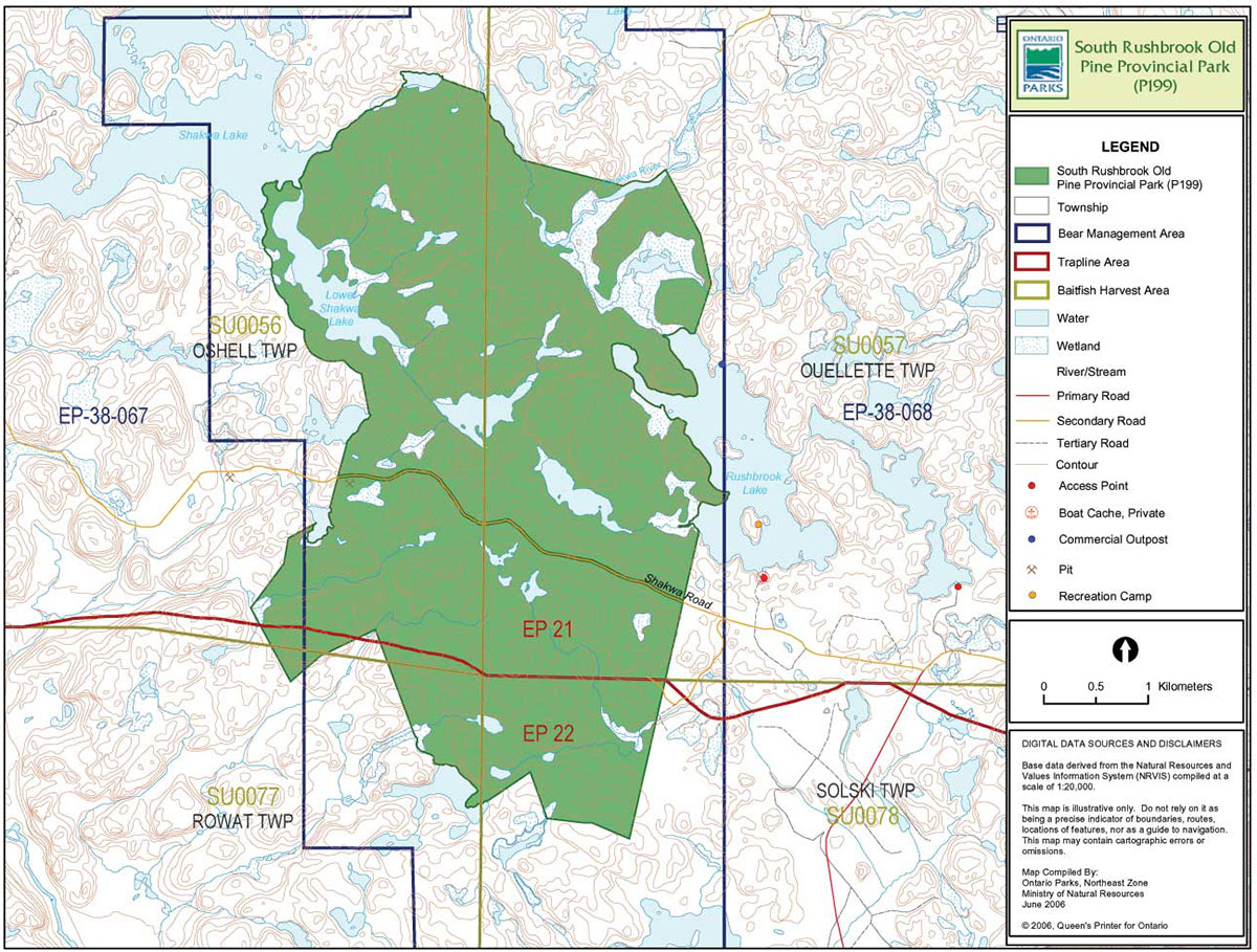
The park boundary includes portions of two licensed bear management areas (BMA): EP-38-067 and EP-38-068 (Figure 3).
Existing commercial bear hunting operations are permitted to continue. This activity may be subject to conditions identified during future management planning (e.g. the designation of nature reserve zones).
New BMA licences will not be permitted (OMNR 2000; 2003).
Trapping
The park boundary includes portions of two licensed trap lines: EP-21 and EP-22 (Figure 3).
Existing commercial fur harvesting operations may continue where the activity has been licensed or permitted since January 1, 1992. New operations, including trap cabins and trails, will not be permitted (OMNR 2000; 2003).
Transfers of active trap line licenses are permitted, subject to a review of potential impacts and the normal transfer or renewal conditions that apply.
5.1.3 Industrial resources
There are two abandoned aggregate pits located within the park boundary. These pits were licensed to and managed by Domtar Incorporated. However, they have been surrendered and are no longer active. These pits will be left to regenerate naturally. Aggregate extraction is not permitted within the park (OMNR 2004a).
There are no existing mining claims within the park. All lands within the park have been withdrawn from mining activity under the Mining Act (1990). Mineral exploration or mineral extraction is not permitted within provincial parks (OMNR 1992).
As outlined in Ontario’s Living Legacy Land Use Strategy, commercial timber harvesting and hydro development are not permitted in South Rushbrook Old Pine Provincial Park.
5.1.4 Access and crossings
Access
Access to South Rushbrook Old Pine Provincial Park is via the Shakwa Road. There is also an access point at the southern end of Rushbrook Lake, outside the park boundary.
Roads
The Shakwa Road bisects the park in Oshell and Ouellette townships. The road corridor is not included within the park boundary.
A small section of a secondary logging road branching from Shakwa Road enters the southeast side of the park.
Where existing roads are essential for continued access beyond the park for forestry, recreation or access to private in-holdings and alternative road access does not exist or road relocation is not feasible, existing roads will continue to be available for access. Continued use will include maintenance and may include upgrading (OMNR 2004a). Upgrading and maintenance activities must meet all Environmental Assessment Act requirements. Ontario Parks is not responsible for the maintenance or upgrading of any existing roads within the park boundary.
Figure 3: Bear Management Areas, Trap Line Areas, and Commercial Baitfish Harvesting

Enlarge Figure 3: Bear Management Areas, Trap Line Areas, and Commercial Baitfish Harvesting
Railways
There are no crossings of the park boundary by railway corridors.
Utility corridors
There are no utility corridors located within the boundary of the park. All public utilities (e.g. gas pipelines, transmission lines, communications towers) must avoid park lands wherever possible. New utility corridor crossings may be necessary to maintain essential public services (OMNR 2004a).
Any future utility corridors proposed through the park, where park lands are unavoidable, will be reviewed on a case-by-case basis. Protection of park features and values will be priority and all requirements of the Environmental Assessment Act will be met.
Recreational trails
There are currently no authorized recreational trails within the park boundary. New trails (e.g. hiking) may be developed if the need arises. Any proposed development within the park is subject to Environmental Assessment Act requirements.
Canoe Routes: Shakwa and Rushbrook Lakes are considered part of the interior lake section of the Spanish River canoe route system.
5.1.5 Adjacent land management
Forestry
The lands adjacent to this park are located in the Spanish Forest Management Unit managed by Domtar Incorporated. The current management plan for this Forest Management Unit will be renewed in 2010.
Provincial parks
Spanish River Provincial Park (P192): This large waterway provincial park is located east and south-east of Rushbrook (Figure 1) and includes 35,386 ha of Crown land. The area is known to have one of the largest remaining old pine forests in Ontario. Pine can be found growing on several landform types with a range of vegetation associations.
General use area
Two general use areas surround South Rushbrook Old Pine Provincial Park.
The West Branch General Use Area (G2035) encompasses 205,954 ha of Crown land. The primary purpose for this area is economic resource development, particularly logging and commercial tourism. However, most other natural resource uses are permitted and the maintenance of the existing environmental quality and acceptable levels of fish and wildlife populations is a management goal.
Spinweb-Gilbert Lakes General Use Area (G2037): Management priorities in this 29,038 ha area include the provision of a high quality road-accessible recreational landscape and the maintenance of a quality wood production area. Most other natural resource uses will also be permitted.
Adjacent tourism developments
A commercial outpost camp and a private recreational camp are located on Rushbrook Lake outside of the park. An access point at the south end of the lake is also outside of the park boundary.
5.1.6 Land disposition
South Rushbrook Old Pine Provincial Park is located in Oshell, Ouellette, Solski, and Rowat townships within MNR Sudbury District.
Land use permits, licenses of occupation, unauthorized occupations
There are no existing land use permits (LUP), private land holdings, licenses of occupation or unauthorized occupations within this natural environment park. The disposition of land for private use will not be permitted within the park (OMNR 2004a).
Waste disposal site
There are no authorized waste disposal sites in South Rushbrook Old Pine Provincial Park.
Boat caches
There are no authorized boat caches located within the park. Boats are not permitted to be left unattended in the park without written permission from the superintendent under the authority of the Provincial Parks Act.
5.2 Aquatic ecosystems
Sustaining quality water resources is integral to the protection of park and adjacent lands values. The MOE enforces applicable legislation and regulations for water quality.
5.2.1 Water management
There are no dams, water control structures, or diversions currently being utilized by the MNR within the park boundaries, nor will any be permitted in the future (OMNR 1992). There is one historical dam located between Upper and Lower Shakwa lakes. There is currently no control schedule for this dam.
5.2.2 Fisheries management
South Rushbrook Old Pine Provincial Park includes Lower Shakwa Lake and several other smaller lakes adjacent to Rushbrook Lake. Some of the park’s coldwater lakes provide habitat for brook trout, lake trout and whitefish.
Fisheries management will complement the maintenance and enhancement of native, self-sustaining fish populations (OMNR 1992).
Sport fishing
Sport fishing is permitted within the park. This activity is governed by legislation and regulations in the Fish and Wildlife Conservation Act and the Fisheries Act (1985). The Recreational Fishing Regulations Summary contains details on the regulations that are applicable to this area.
Commercial fishing
There are no commercial fishing operations within the boundary of South Rushbrook Old Pine Provincial Park. New operations will not be permitted (OMNR 2004a).
Commercial baitfish harvesting
Oshell, Ouellette, Solski, and Rowat townships are currently allocated for commercial bait fish harvesting (see Figure 3). Existing commercial baitfish harvesting may continue where the activity has been licensed or permitted since January 1, 1992. This activity may be subject to conditions identified through future park management planning or fisheries management plans. New baitfish licenses will not be permitted (OMNR 2000; 2003).
Fish stocking
The stocking of native fish species may be considered through park management planning, with full public consultation. Non-native fish species will not be deliberately introduced into park waters (OMNR 1992).
6.0 Operations policies
6.1 Recreation management
6.1.1 Motorized recreation
Motorboats
The use of motorboats is permitted to continue, unless park values are being threatened (OMNR 2004a).
Aircraft
All aircraft landings are subject to regulation and valid aircraft landing permits issued by the park superintendent under the authority of the Provincial Parks Act.
Snowmobiles
There are currently no authorized snowmobile trails within the park. Some snowmobile traffic occurs on Shakwa Road as well as Shakwa and Rushbrook lakes adjacent to the park.
Use of existing trails to access recreational ice fishing areas is permitted to continue unless park values are being threatened. Proposals for new trails may only be considered through future planning with public consultation (OMNR 2000).
Off-road/off-trail use of snowmobiles will not be permitted within park boundaries.
All-terrain vehicles
There are currently no authorized all-terrain vehicle (ATV) trails located within the park. It can, however, be assumed that some ATV traffic occurs on Shakwa Road and a secondary road that branches off the Shakwa Road south of Rushbrook Lake.
Proposals for new trails may only be considered through future planning with public consultation (OMNR 2000).
Off-road use of ATVs will not be permitted within the park boundary.
6.1.2 Non-motorized recreation
Camping
There are currently no developed camping facilities within South Rushbrook Old Pine Provincial Park, however, unmanaged campsites may occur within the park boundary. Ontario Parks may assess the condition of existing campsites and will maintain, rehabilitate or close sites as required. If there is an identified need, new backcountry campsites may be considered (OMNR 2004a). Infrastructure will be permitted in order to protect park features and values in response to use, environmental deterioration and environmental protection requirements. Any proposed development in the park must fulfill the requirements of the Environmental Assessment Act.
Hiking
Presently, there are no known hiking trails located within the park.
Existing hiking trails may be permitted to continue unless such trails threaten park features and values, create user conflicts or raise safety/liability issues.
If there is an identified need, the development of new hiking trails may be considered. Trail infrastructure to protect park values and features will be permitted. Any proposed development within the park is subject to Environmental Assessment Act requirements.
Canoeing/kayaking
Shakwa and Rushbrook lakes are part of the interior lake section of the Spanish River canoe route system.
Existing uses may continue, unless park values are threatened (OMNR 2004a). Infrastructure to protect park features and values may be permitted and developed in response to use, environmental deterioration and environmental protection requirements.
6.1.3 Emerging recreational uses
There are emerging recreational uses for which there is limited or no policy to deal with their management (e.g. adventure racing, geocaching). The park superintendent will use legislation, policy and guidelines that are in place in the interim to manage emerging uses.
6.2 Development
There is no existing park infrastructure located within the park boundary. Infrastructure to protect park features and values may be permitted and developed in response to use, environmental deterioration and environmental protection requirements. Any proposed development within the park is subject to MNR's requirements under the Environmental Assessment Act.
6.3 Commercial tourism
Infrastructure for commercial tourism does not exist within the park.
New commercial tourism facilities may be considered where consistent with park policy (OMNR 2004a). Any development must meet the requirements of the Environmental Assessment Act.
7.0 Cultural resources
An assessment of the cultural resources specific to South Rushbrook Old Pine Provincial Park has not been completed at this time, however upon completion, management of any cultural values within this park will be directed toward protection and heritage appreciation (OMNR 1992).
8.0 Heritage education
Literature and other supporting information may be developed to describe the park in the context of Ontario’s provincial park system. Boundary limits, significant heritage features and permitted uses of the waterway park may be included in park literature.
Prospective park visitors may be informed about the sensitivity and significance of park values through park literature.
9.0 Research
Scientific research by qualified individuals which contributes to the knowledge of natural or cultural history, or to environmental or recreational management, may be encouraged in the park. Ontario Parks will encourage institutions, such as universities, to undertake research projects.
All research programs will require the approval of Ontario Parks and are subject to park policy and other applicable legislation. Any materials removed from the park will remain the property of Ontario Parks.
Approved research activities and facilities will be compatible with the park’s protection objective. Any site which is affected by research will be rehabilitated as closely as possible to its original state. Environmental Assessment Act requirements will apply.
10.0 References
Alkins, M.A., and E.R. Morris, 2002. Life Science Reconnaissance Survey for South Rushbrook Old Pine Provincial Park. Ontario Parks, Northeast Zone, Ontario Ministry of Natural Resources.
Blackburn, C., 2003. Detailed information for site P199 – South Rushbrook (Draft). Ontario Ministry of Natural Resources. 4 pages.
Crins, W.J., 1996. Life Science Gap Analysis for Site District 4E-3. Ontario Ministry of Natural Resources. Queen’s Printer for Ontario: Huntsville, Ontario.
Environmental Assessment Act, 1990.
Fisheries Act, 1985.
Fish and Wildlife Conservation Act, 1999.
Migratory Birds Convention Act, 1994.
Mining Act, 1990.
Morris, E.R., 2002. South Rushbrook Old Pine Provincial Park (P199) Life Science Checksheet. Ontario Ministry of Natural Resources, Ontario Parks, Northeast Zone. 8 pages.
Ontario Ministry of Natural Resources, 1974. A Topical Organization of Ontario History. Historic Sites Branch Division of Parks.
Ontario Ministry of Natural Resources, 1992. Ontario Provincial Parks Planning and Management Policies.
Ontario Ministry of Natural Resources, 1999. Ontario’s Living Legacy Land Use Strategy.
Ontario Ministry of Natural Resources, 2000. Ontario’s Living Legacy Land Use Strategy Policy Clarification.
Ontario Ministry of Natural Resources, 2002. Public and Aboriginal Consultation Documentation Form – Ontario’s Living Legacy Protected Area Boundary Refinement Review – South Rushbrook Old Pine Provincial Park.
Ontario Ministry of Natural Resources, 2003. Directions for Commercial Resource Use Activities in Provincial Parks and Conservation Reserves. 5 pp.
Ontario Ministry of Natural Resources, 2004a. Crown Land Use Policy Atlas.
Ontario Ministry of Natural Resources. 2004b. Forest Fire Management Strategy for Ontario. Aviation and Fire Management Branch.
Ontario Ministry of Natural Resources, 2005. A Class Environmental Assessment for Provincial Parks and Conservation Reserves.
Provincial Parks Act, 1990.
Appendix A: Background information
| Name | South Rushbrook Old Pine Provincial Park (P199) |
|---|---|
| Classification | Natural Environment |
| Ecoregion/Ecodistrict | 4E-3 (Mississagi) |
| OMNR Administrative Region/District | Northeast – Sudbury |
| Total Area (ha) | 2,158 |
| Regulation date & Number | Unregulated |
Representation
Earth science:
South Rushbrook Old Pine Provincial Park lies within a large area of relatively unstudied granitic rock, generally called the Ramsey-Algoma granitoid complex (entirely within the Abitibi Subprovince of the Archean age Superior Province) (Blackburn 2003).
Surficial deposits consist of Holocene age morainal material. North of Shakwa Road, bedrock knobs with up to 20% outcrop protrude through moraine cover. To the south of the road, relief is moderate but hummocky, and outcropping is scarce. The numerous small lakes dotting the area south of Shakwa Road differ from those to the north in that they are not controlled by bedrock, and therefore may be kettle holes. All these features suggest the till had been deposited during stagnation in the retreat of ice (Blackburn 2003).
Organic deposits occupy a portion of the park in the northeast, along Rushbrook Creek where it drains northward into the Shakwa River (Blackburn 2003).
Life science:
South Rushbrook Old Pine Provincial Park is located 27 kilometres west of Cartier and about 15 kilometres west of the Spanish River in Ecoregion 4E (Ecodistrict: 4E-3 -Mississagi).
The park contains three Natural Heritage Areas: South Rushbrook Old-Pine (end moraine), Rushbrook Old-Pine (upland till), and Rushbrook Creek-Shakwa River Marsh (peatland). The South Rushbrook Old Pine Natural Heritage Area (799 ha) is provincially significant and contains the best representation of mature and old-growth Red Pine-White Pine on an end moraine landform in Ecodistrict 4E-3 (Crins 1996). Old-growth pine covers nearly 70% of the park’s total area. There is also a 37 ha stand of mature and old-growth Yellow Birch on the end moraine (Morris 2002). The Rushbrook Creek-Shakwa River Marsh is the largest and most diverse wetland of its type in any provincial park from this section of Ecodistrict 4E-3.
Subordinate tree species in the park include yellow birch, red pine, white pine, white birch, black spruce, white spruce, balsam fir, white cedar, trembling aspen, jack pine, red maple, and sugar maple. The park includes a moose aquatic feeding area, Bald Eagle habitat and a breeding location of Northern Goshawk (Morris 2002).
Cultural resources:
No information on cultural values of South Rushbrook Old Pine Provincial Park is available at this time.
Recreation and tourism:
This park is accessible via the Shakwa Road and a documented access point on the southern end of Rushbrook Lake. Rushbrook Lake, which borders the eastern portion of the park has an established recreation camp and commercial outpost camp (not within park boundary). Despite being bisected by an East-to-West traveling road there are no roads into the northern and southern areas of the park.
Shakwa and Rushbrook lakes, as well as Rushbrook Creek and the Shakwa River, are part of the extensive network of lakes, rivers, and creeks included in a canoe route system. This canoe route is not maintained by the Ontario Ministry of Natural Resources. Additional recreational activities within this park include fishing and hunting.
There are no existing commercial or private recreation facilities located within the boundary of South Rushbrook Old Pine Provincial Park.
Inventories
| Survey Level | Earth Science | Life Science | Cultural | Recreational |
|---|---|---|---|---|
| Reconnaissance | Blackburn 2003 | Morris 2002 | Kutas 2005 |