Spanish River and Biscotasi Lake Provincial Parks Management Statement
This document provides policy direction for the protection, development and management of Spanish River and Biscotasi Lake Provincial Parks and their resources.
Interim Management Statement
January 2002
Approval statement
I am pleased to approve this Interim Management Statement for Spanish River Provincial Park and Biscotasi Lake Provincial Park (including the Park Addition as described in Ontario’s Living Legacy Land Use Strategy (1999)).
This Interim Management Statement will provide direction for the management of these Provincial Parks within the Spanish River Valley Signature Site until a park management plan(s) is approved.
Signed by:
Paul Bewick
Zone Manager, Northeast Zone
Ontario Parks
Date: January 25, 2002
Background information
| Name | Spanish River Provincial Park | Biscotasi Lake Provincial Park |
|---|---|---|
| Classification | Waterway | Natural Environment |
| Site Region/Site District | 4E-3 | 4E-3 |
| OMNR Administrative Region/District | Northeast / Sudbury; Chapleau; Timmins | Northeast / Chapleau |
| Total Area (ha) | 35,386 | 12,283 |
| Regulation Date | October 2001 | October 2001 |
Targets
Earth science representation
| Geological theme | Feature |
|---|---|
| Superior Province of Precambrian Shield Southeastern Abitibi Subprovince |
Spanish – Ice Contact Delta; Ground Moraine; Valley Train Biscotasi – Underlain with silty to sandy till plain with a scattering of granitic and migmatite outcrops and boulders |
Life science representation
| Site type/landscape unit | Species/communities |
|---|---|
| Transition zone between the Boreal Forest Region and the Great Lakes St. Lawrence Region | Spanish – Numerous Old Growth Pine locations; Cobble beaches and Riparian habitat; Oxbow and Delta marshes (silver maple); Pogamasing Lake fen, sand bar and clay beach; Bald Eagle Biscotasi – Aquatic, Wetland and Riparian ecosystems; mixed forests of Jack pine, aspen and white spruce; Bald Eagle |
Cultural resources representation
| Theme | Theme segment |
|---|---|
| Precontact First Nations – Late Archaic or Middle Woodland | Pictograph, archeological campsites, sacred sites |
| Fur Trade – North Shore Lake Huron Area (1770s-1820) | Fur Trading Post(s) |
| Forest Industry – North Shore Lake Huron Lumber (late 1870s - mid 1940s) | CPR Railroad; Early log drives, Logging camps |
| Mining – Sudbury Basin Nickel (1883) | Related hydroelectric projects |
| Early Conservation – 1914s | Archie Belaney (Grey Owl) |
Recreation opportunities
| Day-use | Car camping | Wilderness/backcountry |
|---|---|---|
| Angling and Hunting Canoeing Boating |
Access Point Camping – Spanish River | Spanish River Canoe Route Wakonassin & Agnes Rivers & Pogamasing /Sinaminda /Kennedy area side trips Start point for Mississagi River and Sakatawi canoe routes – Biscotasi Lake Remote camping – Biscotasi Lake |
Inventories
| Survey level/type | Reconnaissance completion date | Spanish River and Biscotasi Lake – Detailed/Completion Date | Spanish River - Required | Biscotasi Lake - Required |
|---|---|---|---|---|
| Earth science | 2002 – Geowest (in prep) 1991 – Noble |
No | No | |
| Life science | 2000 – North-South 1991 – Noble |
additional | No | |
| Cultural heritage | 2001 – Cultural Woodland Heritage Services | 1991 – Adams, N.R. 1980 – Hanks, C.C. |
Yes | Yes |
| Recreational | 2000 – OMNR Checksheet | incomplete | additional | Yes |
| Other | - | - | - | - |
1.0 Introduction
Under the umbrella of the Spanish River Valley Signature Site, the Spanish River Provincial Park and Biscotasi Lake Provincial Park will take direction from this interim management statement (IMS). These parks will proceed with park management planning as a unit. This IMS replaces the 1999 approved IMS for Biscotasi Lake Provincial Park as regulated in 1989.
The Spanish River Provincial Park is located in the geographic Townships of Invergarry, Arden, Lillie, Chalet, Bazett, Cavana, Breadner, Battersby, LaFleche, Athlone, Dennie, Morse, Gilbert, Straleck, Craig, Solski, Tofflemire, Acheson, Venturi, Bigelow, and Dunlop in the Territorial District of Sudbury. Biscotasi Lake Provincial Park is located in the geographic Townships of Hollinger, Smuts, Biscotasi, Arden and Lillie in the Territorial District of Sudbury.
The Spanish River Valley has a rich history, which began centuries ago, with Aboriginal people living on the shores of the Great Lakes and paddling the Spanish River to hunt and fish. Voyageurs and fur traders also paddled these waters, though only in a limited manner. The logging industry moved into the Spanish River area in 1863 but had little impact until the arrival of the railway in 1884. Subsequently, construction of the C.P.R. brought trappers, bushmen and tourists to Biscotasing, and brought lumbermen who drove pine logs down the Spanish River to Georgian Bay. By 1890, logging was the main economic activity, dominated by the Spanish River Lumber Company. The river was part of the log drive until the late 1960s.The Canadian Cooper Company (forerunner of INCO) constructed the first hydro dam at High Falls on the Spanish River, to provide power for the mining industry. The Spanish River Pulp & Paper Company (now Domtar Inc.) also became involved in hydropower production when their groundwood mill was built in Espanola. In addition, Biscotsi Lake has also been associated with Grey Owl (Archie Belaney), who first came to Biscotasing in 1914 to work as a Fire Ranger.
Today, the primary uses of the Spanish River and Biscotasi Lake are for recreational purposes. The river is a popular destination for hunting and fishing, and continues to be a renowned canoe route. The lake a popular angling and tourism area.
2.0 Goal
To provide opportunities for outdoor recreation activities and to protect significant natural, cultural and recreational environments.
3.0 Objectives
There are four objectives that provide direction for the management of parks: protection, recreation, heritage appreciation and tourism.
Protection: To protect provincially significant elements of the natural and cultural landscape.
Recreation: To provide outdoor recreation opportunities.
Heritage Appreciation: To provide opportunities for exploration and appreciation of the natural and cultural heritage.
Tourism: To provide Ontario residents and out-of-province visitors with opportunities to discover and experience the distinctive regions of the Province.
4.0 Classification
Spanish River Provincial Park will be managed according to provincial park policies for a waterway class park. Biscotasi Lake Provincial Park will be managed according to provincial park policies for a natural environment class park.
5.0 Park boundary
Both the Spanish River Provincial Park and Biscotasi Lake Provincial Park Addition were proposed under Ontario’s Living Legacy. The Spanish River (RSO 383/01) and Biscotasi Lake Addition (RSO 382/01) were both regulated under the Provincial Parks Act in October 2001. The original Biscotasi Lake Provincial Park was regulated in 1989 under the Provincial Parks Act, O. Reg. 259/89, Schedule 234.
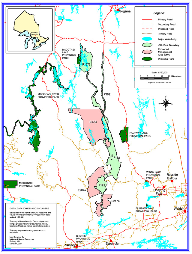
These parks are situated within the Ministry of Natural Resources (MNR) Sudbury, Timmins and Chapleau Districts. See map section.
The park boundary for Spanish River is set back 200 metres from the eastern and lower stretches of the river, and along the west side of Pogamasing and Kennedy lakes southward to Craig Township. The park boundary for Biscotasi Lake is mainly set back 200 metres from waters' edge, though the south-east side takes in a large land base to the Biscotasing and Arden Township line, and the north portion of Lillie Township. It includes the original 1,204 hectares of park land adjacent to the western shoreline.
5.1 Ontario’s Living Legacy – Expansion of Ontario’s protected areas system
Spanish River Provincial Park (P192) and Biscotasi Lake Provincial Park Addition (P1572) were proposed in the 1999 Ontario’s Living Legacy Land Use Strategy (OLL LUS). That document outlines a land use strategy that guides the planning and management of Crown lands in central and portions of northern Ontario.
The Spanish River consists of 35, 386 hectares, where the Biscotasi Lake Addition is 11, 045 hectares. The combined areas of these two parks with the original Biscotasi Lake Provincial Park is 12,283 hectares.
The Spanish River commences from the East Branch in the north at the Eastsand River, and in the northwest from the West Branch at the outlet from Biscotasi Lake to their confluence at the Forks where the river system continues south to Agnew Lake. The protected area is thus 135 kilometres and 140 kilometres long, respectively. With the Biscotasi Lake Addition, the park now includes the main waterbody with many of the contained islands.
Collectively, the two sites have a wide range of values and features requiring protection and/or management. These include but are not limited to:
- The headwaters for the Spanish River
- A popular canoe route
- Old growth forests
- Prehistoric and historic cultural sites
- Provincially and regionally significant natural heritage features
- Species at Risk e.g. Bald Eagle
- Recreational features, e.g. camping sites and historical canoe routes
Natural and cultural heritage areas
Spanish River Provincial Park – Spanish River Valley And Old Pine
This provincially significant area represents a complex of old (120+ years) White Pine and/or Red Pine forests on three different landform units (IV-3, IIa-1, Ia-4) within ecodistrict 4E-3. Substantial White Pine regeneration occurs in this area. It contains a significant stretch of the Spanish River valley corridor (~ 16 km). It also contains several micro-watersheds and tributaries that feed into the Spanish River.
Spanish River Provincial Park – Agnes River Old Pine
This provincially significant area provides the best representation of old White and Red Pine in association with intolerant hardwoods on the valley train landform unit (IVd-3) within ecodistrict 4E-3.
Spanish River Provincial Park – Craig/Tofflemire Old Pine
Provincially significant old growth White Pine can be found in association with other conifers, such as White and Black Spruce and Jack Pine on landform unit IIa-1 within ecodistrict 4E-3. It contains many riparian habitats associated with a small tributary leading to the Agnes River.
Spanish River Provincial Park – Trembley Lake Forest
This regionally significant area has major forest dominants of Jack Pine, Trembling Aspen and Black Spruce spanning a considerable range of ages (35 to 120 years); the result of a history of logging (ca. 1930) associated with the railway line (CPR). The inclusion of old growth White Pine on the slopes and tablelands on the west side of the Spanish River, coupled with the diverse forests of the east side, creates a riparian corridor 5 km in length.
Spanish River Provincial Park – Spanish River Ice Contact Delta
The Spanish River Ice Contact Delta is a provincially significant earth science feature. It is located where the Agnes River joins the Spanish River in Tofflemire Township. Geologists now have evidence that it was formed when glacial ice lay a short distance north of the Rawhide Moraine, when a ponded meltwater lake existed. Known as the Wyebride ice margin, meltwaters flowing off the glacier carried sands and gravels into a larger glacial Spanish River to form this delta.
Spanish River Provincial Park – Spanish River / Path Creek Delta
This feature is located where Path Creek joins the Spanish River on the boundary between Morse and Stralak Townships. It was formed in a high meltwater situation as glacial ice formed the Cartier III Moraine. Thus it is above, or perched higher than the present flow levels of the Spanish River. The surface of this ice contact delta is pocked with depressions, called "kettles".
Biscotasi Lake Provincial Park – Old Conifer
Most of the vegetation types in the park have a boreal affinity with Black Spruce and White Birch dominated forests. Of significance is a 100+ year old White Cedar-White Birch stand in the addition.
Biscotasi Lake Provincial Park – Prehistory archeological sites
There is a complex of significant prehistoric sites within the park addition. These contain archaeological evidence of human occupation from the Early Archaic (circa 5,000-500 B.C.) through to the Late Woodland periods (circa A.D. 900-A.D. 1700).
Recreational values and ecological boundaries
The Spanish River is a provincially significant canoe route. It is rated as novice to intermediate level river for canoeing and backcountry travel on a challenging and scenic waterway. The river supports both traditional remote tourism and eco-adventure tourism. Ecologically, the area is a valley complex with cliffs and valley bottoms, along with riparian and delta ecosystems.
Biscotasi Lake is the starting point for three canoe routes: Spanish River, Mississagi River and the Sakatawi. Camping occurs on the various islands and on Lost Lake, and a thriving resource-based tourism economy exists on the lake. Ecologically, aquatic ecosystems, such as open water, wetlands and riparian are well represented in this area.
Land use intent
The Spanish River Special Area Plan will guide management activities for that portion of the provincial park that applies to the Special Area Plan, including road access and river crossings, until a provincial park management plan is approved. As stated in the OLL LUS for the Spanish River Provincial Park, park management planning will determine future management direction for existing or new river crossings. Also, future planning will ensure that land use activities and access adjacent to the park, do not impair the recreational and tourism values. The Biscotasi Local Area Land Use Strategy must be considered in the development of the park management plan for that portion of the provincial park applicable to the Biscotasi Local Area. Information and direction developed in future park management planning will be shared with other planning processes dealing with land use activities and access adjacent to the park.
6.0 Aboriginal interests
Spanish River Provincial Park and Biscotasi Lake Provincial Park are within the lands covered under the Robinson-Superior 1850 Treaty and the James Bay Treaty of 1905 (Treaty No. 9). Sagamok Anishinawbek is located near Massey at the mouth of the Spanish River at Lake Huron. Mattagami First Nation is located south of Timmins on Mattagami Lake west of Hwy 144. Brunswick House First Nation is located near Chapleau. Ontario Parks understands that these First Nation communities are the primary communities that have traditional interest within these parks.
Existing Aboriginal or treaty rights, which are protected under the Constitution of Canada, will be respected. Consultation that began with the Lands for Life Round Tables, with Aboriginal peoples who have existing Aboriginal or treaty rights, will continue and will be an integral part in the development of these park management plans. The process for consultation with First Nations will be determined their involvement prior to detailed discussions with affected communities.
Discussions may include, but are not limited to:
- Traditional uses by each community of the protected areas
- Identification and long-term protection of sacred Aboriginal sites
- Economic participation and opportunities in the resource and tourist industries
- Opportunities for participation in the management of protected areas
Traditional resource use, by Status Indians with Treaty Rights, for subsistence and ceremonial purposes, may occur. Such activities will conform to objectives for conservation and public safety.
7.0 Resource management policies
Spanish River Provincial Park and Biscotasi Lake Provincial Park will be managed as a waterway class park and a natural environment class park respectively. Accordingly, Provincial Parks Planning and Management Policies (1992), Ontario’s Living Legacy Land Use Strategy (1999) and Ontario Provincial Park Policy as amended by the OLL LUS (2000) provide policy direction for their management. For Spanish River Provincial Park and the addition to Biscotasi Lake Provincial Park, the OLL LUS determines permitted uses. Any outstanding policies not addressed in the OLL LUS will look to the Provincial Parks Planning and Management Policies for direction. Provincial Parks Planning and Management Policies dictate permitted uses for the portion of Biscotasi Lake Provincial Park that existed prior to OLL. In the following discussion on the guidelines for management, please note that references to "the park" are providing policy direction for both parks, unless otherwise stated.
7.1 Vegetation management
Vegetation in the park will be managed in keeping with natural vegetation succession processes. Vegetation will be managed to fulfill protection and recreation objectives.
Commercial forestry and fuel wood cutting are not permitted within the park.
7.1.1 Vegetation control
The removal of trees will occur, by authorized staff, in areas where there is a threat to public safety and property or where it is necessary to meet the parks protection and recreation objectives. Non-native species will not deliberately be introduced. Missing native plant species may be re-established if biologically feasible and acceptable.
7.1.2 Insects and disease
Insects and disease may be managed where aesthetic, cultural, or natural values are threatened. Guidelines established by the Ontario Ministry of Natural Resources and the Ontario Ministry of Environment will be implemented. Biological controls will be used in preference to chemicals, where feasible.
7.1.3 Forest fire management
Forest fire protection occurring within the boundaries of the park will be implemented according to the prevailing Fire Area Strategies. Protection from fire will be provided in all cases where life and property are threatened.
7.2 Water management
Both parks are influenced by the Spanish River Watershed Water Management Plan (1993). The emphasis on management of the Spanish River Watershed is optimizing the benefits for both recreational and industrial users. The Ministry of the Environment enforces applicable legislation and regulations for water quality. Water control structures are discussed in Section 7.7.2.
7.3 Fisheries management
Fisheries management activities will be aimed at the maintenance and enhancement of native, self-sustaining fish populations.
7.3.1 Non-native fish introductions
Non-native species will not deliberately be introduced. Where they are already established, management programs for eradication may be developed, if it is practical or feasible for the perpetuation of the values for which the park was established.
7.3.2 Bait fish
Provincial park policy for natural environment class parks (Biscotasi Lake) states that the use or possession of bait fish is prohibited. Similarly, for waterway class parks (Spanish River) the policy states that the use or possession of bait fish is prohibited, except in high-intensity (higher concentration of facilities) areas. (Refer to Ontario Recreational Fishing Regulations Summary for definition of bait fish).
In order to comply with provincial park policy and reduce the risk of accidental introductions, regulations to restrict or eliminate the use of live bait may be established. Prior to any changes in fisheries management or regulations further public consultation through park management planning, in cooperation with the MNR District office, will be carried out. Traditional angling use in the area has evolved with live bait angling. The use of baitfish for sport fishing occurs in the majority of the park waterbodies. It is assumed that future effects of live bait fish on park lakes would be negligible.
7.3.3 Sanctuaries
Prior to any changes in fisheries management or regulations further research and public consultation will be carried out to determine the status of angling and fish populations. Sanctuaries are established under the Fish and Wildlife Conservation Act.
7.3.4 Sport fishing
Sport fishing is permitted, except in established fish sanctuaries.
Ontario’s Living Legacy Land Use Strategy (1999) has not altered provincial park policies for sport fishing. Sport fishing is permitted as per the Ontario Recreational Fishing Regulations Summary.
Both the Spanish River and Biscotasi Lake are classed as warm water bodies. It is stated in The Biscotasi Lake Local Area Land Use Strategy, that there is a concern about the health of the fishery. Currently the fisheries are managed through District Fisheries Management Plans. Further policy may be established during the park management planning process.
For the area covered under The Biscotasi Lake Local Area Land Use Strategy, specific fisheries management strategies have been implemented and will be adhered to until alternate decisions are made under the park management plan. Its objective is to enhance the walleye angling quality in the central portion of Biscotasi Lake and maintain a healthy walleye population across the entire lake.
Special fisheries management techniques may be implemented in order to protect and improve speckled (brook) trout populations on the cold water tributaries that enter Spanish River within the park.
7.3.5 Commercial fishing and bait harvesting
Existing commercial bait harvesting occurs within both parks.
Existing use within the park will be permitted to continue indefinitely, except in nature reserve zones, subject to possible conditions identified in Provincial Park and Fisheries Management Plans. An exception to this is in the 1989 regulated portion of Biscotasi Lake Provincial Park where commercial bait fish harvesting will be phased out by 2010 in wilderness and nature reserve zones (if applicable). Zoning will be determined through future park management planning
No new operations will be permitted.
7.3.6 Fish stocking
The Ministry may stock native fish from hatcheries in lakes to provide put and delayed take angling opportunities. An exception to this policy is in waterway class parks (Spanish River) where stocking is prohibited in wilderness and nature reserve zones isolated from the waterway. Zoning will be determined through future park management planning.
Stocking programs must avoid actions that would affect native populations.
Prior to any stocking activity a park management plan must be approved and the following should be considered:
- Whether it is permitted or not by planning and management policies
- Whether a lake has been stocked in the past and current populations` are depleted from high fishing pressure
- Whether lakes have been stocked and the existing population is reproducing naturally
- Whether a lake’s fish population has been 'wiped-out' by acidification or other catastrophic event
- Whether a lake contains sufficient forage base, depth and suitable spawning habitat and the sportfish does not exist
7.4 Wildlife management
Portions of Wildlife Management Units 37, 38 and 39 fall within Spanish River Provincial Park. Biscotasi Lake Provincial Park contains WMU 38 and 39. The area is noted for good concentrations of Moose habitat and other mammals such as Black Bear, Lynx, Timber Wolf, Red Fox, Mink, Pine Marten inhabit the area. Due to the riparian nature of the waterways, Beaver, River Otter and Muskrat are plentiful. Heron, Osprey and Bald Eagle have been noted in both parks but are not well documented. The Natural Heritage Information Center Database contains an unverified record of a pair of Peregrine Falcon with fledgling sighted on the Spanish River, though the eyrie is unknown.
Select controls of animal populations will be implemented under the strict supervision of the Park Superintendent, or directly by, the Ontario Ministry of Natural Resources. Such control will only be directed at populations requiring attention (e.g. animals compromising public safety).
Sensitive areas within the park will be recorded and appropriately managed, as they are identified.
7.4.1 Hunting
Sport hunting is permitted within Spanish River Provincial Park and Biscotasi Lake Provincial Park. Future park management planning process will identify zoning that may result in restrictions (e.g. hunting is only permitted in natural environment zones in pre-OLL parks and excluded in nature reserve zones in OLL parks). Consideration of safety and conservation with respect to hunting will be made during park management planning with public involvement.
As unauthorized occupation structures, permanent tree stands (for hunting) are not permitted and existing structures will be removed within five years of an approved park management plan.
7.4.2 Trapping
There are 25 authorized traplines and 5 trap cabins within Spanish River and Biscotasi Lake Provincial Parks.
Commercial fur harvesting will be permitted to continue indefinitely, except in nature reserve zones. An exception to this is in the 1989 regulated portion of Biscotasi Lake Provincial Park where there is no licensed commercial trapping and no new operation are permitted.
New operations including trap line cabins and trails will not be permitted. The relocation of existing trails and cabins will be subject to ecological principles and management planning.
If a commercial license is revoked or surrendered, all portions of the registered trap line within the park will be rescinded from the trap line’s legal description.
7.4.3 Bear Management Areas (BMA)
There are BMA licenses issued within the boundaries of both parks.
An existing authorized BMA license may be renewed or transferred. Future park management planning process will identify zoning that may result in restrictions (e.g. renewals or transfers will not be permitted in nature reserve and wilderness zones). The renewal and transfer of BMA licenses will be addressed through park management planning and will consider conservation principles and public safety.
7.5 Mineral exploration
Within Spanish River Provincial Park and Biscotasi Lake Provincial Park Addition, mineral exploration may occur under controlled conditions in areas designated as having provincially significant mineral potential (PSMP). The Ministry of Northern Development and Mines (MNDM) will identify, through further analysis and consultation, whether there are areas of PSMP within the park. If exploration occurs and a site is to be developed for a mine, it would be deregulated, and a replacement area added to the park.
During the life of this IMS, for the portion of the park that lies within the jurisdiction of The Spanish River Special Area Plan and The Biscotasi Local Area Land Use Strategy, the management principles and strategies in these documents as they relate to mineral exploration will apply. Exploration is permitted to the extent that they do not comprise the recreational experience or the semi-remote nature of the area. Aggregate extraction will not be permitted.
An exception to the above is in the1989 regulated portion of Biscotasi Lake Provincial Park where mineral exploration and extraction, including aggregates, is not permitted.
7.6 Adjacent land management
Areas adjacent to Spanish River and Biscotasi Lake Provincial Parks may have implications to park management. Detailed descriptions and policies related to these areas can be found in Ontario’s Living Legacy Land Use Strategy (1999). One new land use category is an Enhanced Management Area (EMA), created as a result of Ontario’s Living Legacy. These areas were established to provide more detailed land use direction in areas of special features or values. Another new land use category is a Forest Reserve. Forest Reserves associated with pre-existing mining land tenure are presently excluded from the provincial park landbase but are contiguous, meaning that it is the intent that these areas will be added to protected areas as mining claims or leases are retired through normal processes. There are a number of small Forest Reserves associated with the Spanish River Provincial Park.
The following are adjacent areas of concern:
Mississagi River Provincial Park – OLL Addition
Mississagi River Provincial Park provides opportunities for boating, canoeing, along with angling and hunting. This waterway-classed park is rich in history beginning with Aboriginal people, followed by the Voyageurs and fur traders, loggers, trappers and tourists. The river’s reputation is associated with Grey Owl, who first came to Biscotasing in 1914 to work as a Fire Ranger along portions of the Mississagi waterway. With their respective OLL Additions, Biscotasi Lake and Mississagi River Provincial Parks now share a common boundary.
Sinaminda and Kennedy Lake enhanced management area (E193r)
The east portion of this EMA abuts Spanish River Provincial Park. The area encompasses approximately 34,461 hectares and is a high-quality recreation area. Activities include canoeing, boating, fishing, hunting, trapping, baitfishing and snowmobiling. Recreation camps and outpost camps are located in this EMA. Road access is restricted. Trout have been stocked in lakes within this EMA.
Land use and resource management activities will be compatible with protecting the recreational values of the Spanish River Provincial Park.
Acheson Lake enhanced management area (E204a)
This relatively remote area containing old growth Red and White Pine encompasses 8,627 hectares. Activities include traditional recreation pursuits and resource extraction.
Land use directions within this area will be compatible with protecting the natural and recreational values of the Spanish River Provincial Park.
Swann Lake enhanced management area (E217a)
At 7,877 hectares this relatively remote area is currently managed as a remote access area. It includes an excellent moose population, stocked lakes and good quality remote hunting and fishing opportunities. Mining and forest resources are also important in the area.
Land use directions within this area will be compatible with protecting the natural and recreational values of the Spanish River Provincial Park.
Biscotasi Lake enhanced management area (E1044r)
This area is approximately 32,859 hectares and is located southwest of Biscotasi Lake and abuts the southwestern most area of Biscotasi Lake Provincial Park. This area has been designated as an enhanced management area (EMA) for recreation.
7.6.1 Forest Operations
Forest Management activities in the adjacent areas to the Spanish River and Biscotasi Provincial Parks are carried out by two Sustainable Forestry Licence holders, Domtar Inc. and Northshore Forest Inc. Together the parks offer a significant water-based recreational area, and since adjacent harvesting has resulted in impacts to the waterway in the past, it is important to minimize the effects of timber harvesting on the river environment and users of the waterway.
Ontario Parks will participate in the forest management planning process to ensure park values are protected. Discussions will consider, but are not limited to the following:
- No commercial harvesting within the park
- Viewshed Management
- A "No Roads Zone" (including tertiary roads)
- Timing restrictions (season) of harvest
- Restrictions on all roads under authority of the Public Lands Act that may permit unauthorized access into the park
7.7 Land management
All patent land has been excluded from the Spanish River and Biscotasi Lake Provincial Park boundaries, however due to its nature the park can surround patent land. This includes mining patent and recreational property.
During the life of this IMS, for the portion of the park that lies within the jurisdiction of The Spanish River Special Area Plan and The Biscotasi Local Area Land Use Strategy, the management principles and strategies in these documents as they relate to land management will apply. Any changes to existing land use tenure must be compatible with the limits of the planned land use intent and resources in the area.
A life science report was prepared by North-South Environmental Inc. for the Spanish River Signature Site, April 2001, that includes the Spanish River Provincial Park and Biscotasi Lake Provincial Park Addition. Similarly, an earth science inventory is underway. Earth and life science inventories and reports were completed in 1991 for the 1989 regulated portion of Biscotasi Lake Provincial Park.
Sensitive areas within these two parks will be recorded and manage accordingly to satisfy known values.
7.7.1 Land Use Permits
Land tenure in Spanish River Provincial Park, is limited to a number of Land Use Permits (LUPs) on the river and Pogamasing / Kennedy lakes, associated with private recreational camps, boathouses and commercial outpost camps.
Land tenure in the Biscotasi Lake Provincial Park is limited to a number of Land Use Permits (LUPs). Existing authorized LUPs will continue subject to terms and conditions of the disposition permitted through current policy. An existing LUP cabin associated with a trapline will be reviewed during future park management planning (Refer to Section 7.4.2). No new land disposition for private recreational use will be permitted.
7.7.2 License of occupation
Water control structures, contained within the Spanish River Provincial Park, are located at Pogamasing Creek and Kennedy Lake. Domtar Inc. (Espanola) operates the concrete structure with stop logs at Pogamasing Creek, under a License of Occupation (JL280). The Kennedy Lake dam, under License of Occupation #06429, was canceled and decommissioned in 1964. Currently there is a rock weir at the site of the old dam.
There are three dams contained within Biscotasi Lake Provincial Park, two are at the outflow to the West Branch of the Spanish River and the other is at the Dead River outflow. These are the responsibility of INCO (Sudbury), under a License of Occupation (#8802).
There will be no alterations to the status of these water control structures.
7.7.3 Boat caches
Boat caching in association with LUP access occurs on the Spanish River. Currently, in the Spanish River Provincial Park some known locations are south of the Oxbow, south of Mogo Creek, Lebel Lake, at Sheahan station, Spanish Lake and Acheson Lake.
Boat caches will be reviewed during future park management planning.
7.7.4 Cottage lots
Patent cottage lots occur on Pogamasing, Kennedy and Biscotasi Lakes.
No new sales of Crown land for the private use of individuals or corporations will be permitted.
7.7.5 Private recreational camps
There are a number of recreational camps located within Spanish River and Biscotasi Lake Provincial Parks; 26 and 2 respectively.
Existing authorized recreational camps within the park are permitted to continue, and may be eligible for enhanced tenure but not purchase of land.
Enhanced tenure will not be granted if significant natural or recreational values are compromised. Any proposal for enhanced tenure will be determined on a case-by-case basis.
If an existing recreation camp holder wishes to relinquish their tenure and to sell any existing improvements, MNR will consider purchase of the improvements.
7.7.6 Hydro development
Hydroelectric development and new dams are not permitted in the park. Existing structures will continue to operate as per existing conditions.
7.7.7 Tourism facilities and recreational trails
Tourism operations within Spanish River Provincial Park are limited to two resource-based tourism business (Shooting Star Camps and Sudbury Aviation), who operate commercial outpost camps; 8 and 1 respectively. There are no authorized trails for mechanized or non-mechanized use.
Tourism operations within Biscotasi Lake Provincial Park involve one commercial outpost camp, operated by Grey Owl Camps. There are no authorized trails for mechanized or non-mechanized use.
Existing authorized tourism operations will be permitted to continue in Spanish River and Biscotasi Lake Provincial Park, subject to management prescriptions determined through future park management planning.
Existing tourism facilities may be eligible for enhanced tenure. New tourism facilities can be considered where consistent with existing park policy. Decisions on these items will be made during park management planning.
During the life of this IMS, for the portion of the park that lies within the jurisdiction of The Spanish River Special Area Plan and The Biscotasi Local Area Land Use Strategy, the management principles and strategies in these documents as they relate to tourism will apply. The Biscotasi Local Area Land Use Strategy states that no new land use permits for outpost camps or main lodges operations will be issued in this area. The Spanish River Special Area Plan states that new commercial tourism ventures and proposals to alter, relocate, or expand existing commercial operations will be reviewed through the procedures for amending the DLUG.
7.8 Access
Park access needs will be evaluated through future park management planning. Currently, access to the canoe route occurs at the following locations:
- Biscotasi Townsite
- Duke Lake
- Agnew Lake
- The Elbow
- Spanish Lake
- Number of stops on the CPR Railway
- Via the Mississagi River Provincial Park canoe route
There are ample opportunities to access the Spanish River by ATV, 4×4 or snowmachine due to the presence of numerous old tote roads. Land access to Biscotasi Lake Provincial Park is limited to water or air access.
During the life of this IMS, for the portion of the park that lies within the jurisdiction of The Spanish River Special Area Plan and The Biscotasi Local Area Land Use Strategy, the management principles and strategies in these documents as they relate to access points will apply. The Biscotasi Local Area Land Use Strategy states that the access point at Flying Post Bay in Smiuts Twp will be closed and no additional access points will be permitted on Biscotasi Lake. The Spanish River Special Area Plan states that the two access points at Duke Lake and The Elbow will be maintained.
Unauthorized access will be addressed in park management planning. Refer to Section 7.8.1 and 7.9.
7.8.1 Roads
Historically, there was limited access to Spanish River and Biscotasi Lake Provincial Parks. Traditionally, rail had been the main method of access, followed by water routes. However, most notably on the Spanish River, construction of logging roads adjacent to the park has resulted in trails being cut to the waterway, which afford unauthorized access. Currently, the Spanish FMP has implemented measures to control motorized access to Biscotasi Lake through the posting of signs, and through some road abandonment, in recognition of the semi-remote recreational values, tourism values and aesthetics. Similar, restrictions are placed on roads in the vicinity of Kennedy Lake.
During the life of this IMS, for the portion of the park that lies within the jurisdiction of The Spanish River Special Area Plan and The Biscotasi Local Area Land Use Strategy, the management principles and strategies in these documents as they relate to access roads will apply. The Biscotasi Local Area Land Use Strategy states that no new road will be located within 400 metres of the high water mark of Biscotasi Lake. The Spanish River Special Area Plan states that intrusion of numerous roads is considered inappropriate because uncontrolled access will impact on the quality of remote recreational opportunities. To that end strategies for resource access roads adjacent to the Special Area will complement the land use intent of the Spanish River.
Decisions on existing and new roads will be made as part of future park management planning. Once implemented, access to areas of the park that are not designated as access points will be restricted. Traditional means of access to property (e.g. patent land, active mining tenure and LUPs) will continue, subject to management prescriptions made during park management planning.
7.8.2 Aircraft
There is moderate use of aircraft to access the park, generally in relation to providing a service for canoeists or fly-in outpost camps. Periodically, aircraft is used to access or supply private recreation camps and cottages.
Air access to the Spanish River and Biscotasi Lake Provincial Parks will be reviewed in future park management planning with a view to permit key access for aircraft as per the Provincial Parks Act. All aircraft using the park (including those from outpost camps, lodges, and LUP use) will be required to have a valid authorized Aircraft Landing Permit.
7.8.3 Snowmobile
Snowmobile use within the parks is generally related to accessing recreation camps and cottages and subsequent recreational use (e.g. ice fishing).
Snowmobile use will continue until such time that it is reviewed in future park management planning. Zoning may result in restrictions and local use trails may be authorized subject to management prescription. New trails may be considered where consistent with park policy.
7.8.4 All-terrain vehicles
Though undocumented, all-terrain vehicles use does occur in the parks by all types of users, from recreationalists to resource harvesters.
Use of all-terrain vehicles (ATVs) may be permitted within the park. Future park management planning will identify zoning that may result in restrictions (e.g. ATV use may be permitted only in development and access zones if supported by the park management plan).
7.9 River crossings
During the 1990 -1995 Upper Spanish Forest FMP work schedule, two bridges, known as the West and East Metagama bridges that cross the West and East Branches respectively of the Spanish River, were approved (under decisions made in the Special Area Plan). This road is gated and posted as allowing no access to the river.
During the life of this IMS, for the portion of the park that lies within the jurisdiction of The Spanish River Special Area Plan the management principles and strategies in this document as they relate to river crossings will apply. Bridge crossing may be permitted only at the two locations decided in the SAP and no additional crossings will be permitted on the Spanish River.
Future park management planning will determine future management direction for existing or new river crossings, as stated in the OLL LUS. No road crossings were identified for forestry purposes under Article 20 of the Ontario Forest Accord.
8.0 Operations policies
8.1 Recreation management
Present recreational use of the area includes canoeing, camping, boating, fishing, and hunting. The Spanish River canoe route continues to be a well-known waterway among backcountry enthusiasts. Although no survey of area users has been carried out, it is expected that the waterway receives at least a moderate level of use. A recreation use assessment may be undertaken in the future.
8.1.1 Motorboats
Motorboats (private and commercial) may be permitted on designated waterbodies where compatible with protection values, or where essential to maintain a viable water travel experience (e.g. boating is a major existing activity). However, horsepower may be restricted.
This activity will be reviewed during future park management planning, with full public consultation. Planning may consider horsepower restrictions if necessary.
8.2 Development
There are minimal facilities such as outbuildings (with the exception of a few privies) and docks related to the park. Users have developed backcountry campsites over time. In the past MNR Districts operated Crown land recreation programs to maintain campsites and portages. These were discontinued in the 1970's. Future park management planning will assess the need for facilities and a maintenance program.
8.3 Cultural resources
An extensive archeological study of the Spanish River between Spanish and Agnew lakes was carried out in 1980, which identified numerous archaeological and historical sites. A cultural resources inventory for the existing Biscotasi Lake Provincial Park was completed in 1991, which identified sites within the central body of the lake, that are now contained in the Addition. Further studies are underway.
Archaeological and historical resources will not be removed or altered in any way. Appropriate personnel of the Ministry of Citizenship, Culture and Recreation (MCzCR) will be consulted whenever issues relating to the management of cultural resources arise. If applicable, Ontario Parks will ask for involvement of First Nations to determine measures for long term protection of sacred Aboriginal sites and traditions on Crown lands.
8.4 Research
Apart from the earth and life science inventories and the cultural resources inventory, Spanish River and Biscotasi Lake Provincial Parks have not been well studied. There is therefore considerable potential for research in the park (e.g. survey of recreational use).
Scientific research, by qualified individuals, which contributes to the knowledge of natural and cultural history and to environmental and recreational management, will be encouraged in the park. Ontario Parks will encourage institutions to undertake research projects. All research programs will require the approval of Ontario Parks and will be subject to Provincial Park policy and other applicable legislation.
Ontario Parks may approve the research of natural or cultural values by qualified researchers in accordance with the Ontario Parks Research Policy (PM 2.45).
8.5 Commercial tourism (refer to Section 7.7.7)
Spanish River and Biscotasi Lake Provincial Parks currently support resource base and eco-adventure tourism. There are outpost camps within the park. A number of tourist outfitters cater to canoeist on the Spanish River canoe route.
There are a number of existing adjacent commercial tourism operations that promote the recreational features of both the Spanish River and Biscotasi Lake. Possible expansion of commercial tourism facilities may be addressed during future park management planning.
8.6 Natural heritage education/marketing
Spanish River Provincial Park is promoted through a canoe route brochure distributed by MNR (available at District Offices). A description of the river also appears in the MNR publication "Canoe Routes of Ontario". Other non-government interests promote the use of the area (e.g. Reid & Foster; Callan; Kraus). Refer to section 8.0 for more details. Chrismar Mapping Services Inc., under its "The Adventure Map" series publishes a Spanish River canoe route map.
The Spanish River and Biscotasi Lake are also promoted as recreational locations in a variety of tourism brochures and commercial tourism publications.
Canoe route information will continue to be available from the Ministry of Natural Resources. Ontario Parks may take a more active role in providing information once the park is operational.
The need and method to convey specific resource management messages will be evaluated in future park management planning, to ensure park resources are protected from degradation (e.g. garbage, tree cutting, unauthorized access, boat caches, etc.).
Future park management planning will identify how Ontario Parks will promote park visitation and recreational use (e.g. Northeast Zone Natural Heritage Education Plan).
9.0 References
Adams, Nicholas R. 1991. Cultural Resources Inventory – Biscotasi Lake Provincial Park.
Callan, Kevin. 1996. Up a Creek: a paddler’s guide to Ontario. Boston Mills Press, Erin, ON.
Chrismar Mapping Services Inc., no date. The Spanish River Canoe Route: "The Adventure Map" series.
Geowest Environmental Consultants Ltd., in progress. Earth Science Inventory of the Spanish River Valley Signature Site.
Hanks, Christopher C. 1980. The Archaeology of the Spanish River, INCO Spanish River Project.
Kraus, E. no date. Website: Kanu Links.
Lampel, Joseph 1980. "History of the Spanish River" in The Archaeology of the Spanish River.
Noble, T.W. 1991. Earth Science Inventory: Biscotasi Lake Provincial Park.
Noble, T.W. 1991. Life Science Inventory: Biscotasi Lake Provincial Park.
North-South Environmental Inc., 2001. Life Science Report of the Spanish River Valley Signature Site
OMNR, no date. Canoe Routes: Sakatawi. Chapleau District.
OMNR, no date. Spanish River Canoe route description. Gogama District.
OMNR, no date. Sudbury, Timmins, Chapleau Districts: NRVIS, 2001.
OMNR, no date. 1985-1990. Spanish River Special Area Plan files, Sudbury District Office.
OMNR, no date. Parks Operations Binder. Policies, Procedures and Bulletins.
OMNR, 1983. District Land Use Guidelines (DLUG): Sudbury.
OMNR, 1983. District Land Use Guidelines (DLUG): Chapleau.
OMNR, 1983. District Land Use Guidelines (DLUG): Espanola.
OMNR, 1983. District Land Use Guidelines (DLUG): Gogama.
OMNR, 1992. Canoe Routes of Ontario, McClelland & Stewart Inc., Toronto.
OMNR, 1992. Ontario Provincial Parks: Planning and Management Policies.
OMNR, 1999. Ontario’s Living Legacy Land Use Strategy. Queen’s Printer for Ontario.
OMNR, 1999. Ontario Forest Accord – "A Foundation for Progress".
OMNR, 1999. Biscotasi Lake Provincial Park: Interim Management Statement.
OMNR, 2000. Ontario Provincial Park Policy as Amended by the OLL LUS.
OMNR, 2000. Recreation Inventory Report: Spanish River Provincial Park P192 (Philipp, K.)
Reid, Ron and Janet Grand, 1985. Canoeing Ontario’s Rivers, Douglas & McIntyre, Vancouver.
Woodland Heritage Services Ltd., in progress. Spanish River Valley Signature Site Reconnaissance - Stage One Cultural Heritage Assessment.
Map section
Figure 1: Spanish River Valley signature site