Stormy Lake Conservation Reserve Management Statement
This document provides policy direction for the protection, development and management of the Stormy Lake Conservation Reserve and its resources.
C2313
Statement of Conservation Interest
June, 2003
Dryden District
Ministry of Natural Resources
Approval Statement
We are pleased to approve this Statement of Conservation Interest for the Stormy Lake Conservation Reserve (C2313).
This Statement of Conservation Interest will provide guidance for the management of the Conservation Reserve and form the basis for ongoing monitoring of activities. More detailed direction is not anticipated at this time. Should significant facility development be considered or complex issues arise requiring additional studies, more defined management direction, or special protection measures, a more detailed Conservation Reserve Management Plan will be prepared with full public consultation.
The Stormy Lake Conservation Reserve will be managed under the jurisdiction of the Wabigoon Area supervisor, Dryden District, Ministry of Natural Resources.
Signed by:
R.G. McColm
Dryden District Manager
Ministry of Natural Resources
Date: June 30, 2003
Signed by:
Charlie Lauer
Regional Director
Northwest Region
Ministry of Natural Resources
Date: July 16, 2003
1.0 Background information
The purpose of this document is to identify and document the natural heritage values of the Stormy Lake Conservation Reserve, the activities that occur there and, through a set of management guidelines, lay out the activities that will and will not be permitted. For more information regarding this Statement of Conservation Interest (SCI) please refer to the "Conservation Reserve Policy and Procedure PL3.03.05".
Table 1.1: Background information for the Stormy Lake Conservation Reserve.
| Name | Stormy Lake Conservation Reserve (C2313) |
|---|---|
| Site Region / Site District | 4S-5 |
| OMNR Administrative Region / District / Area |
Northwest Region / Dryden District / Wabigoon Area, Wabigoon Forest |
| Total Area (ha) | 412 |
| Regulation Date | Anticipated for 2003 |
| First Nations | Wabigoon Lake Ojibway Nation, Eagle Lake First Nations |
| OBM | 15540054600, 15550054600 |
| Lat. / Long. | 49' 20 / 92'19 |
| Basemap | 54546, 55546 |
| General Location Description |
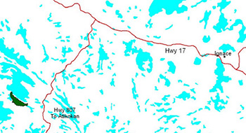
Located approximately 75 kilometers from the City of Dryden on the south shore of Stormy Lake |
| Access | A boat can be launched into Snake Bay of Stormy Lake, approximately 25 km down Snake Bay Rd. off of Hwy. 17. It takes approximately a half hour by boat to get to the south shore of Stormy Lake where the reserve is located. |
Table 1.2: Representation Targets – A summary of earth science, life science, cultural resource values and present or possible recreational opportunities.
| Life Science Representation | Upland Forest/Forested Dunes: Cedar dominated mixedwood forest – white birch, white spruce Drier uplands – jack pine, black spruce and large- leaved aster Aspen dominated mixedwood – balsam fir and spruce Whitepine mixedwood Wetland: Cedar swamp Meadow marshes – beaked sedge, lake sedge, jewelweed, water hemlock, wild raspberry Shore fen – semi-floating wire sedge Animal Species: Moose, red squirrel, bald eagle, sandpiper spp., red- breasted nuthatch, white-throated sparrow, black- capped chickadee |
|---|---|
| Earth Science Representation | Bedrock: - located at the eastern end of the Manitou – Stormy lakes greenstone belt - underlain with Archean age volcanic rock of the Wabigoon Subprovince - straddles the contact between mafic volcanic rocks of the Wapageisi group and overlying pyroclastic rocks. Surficial Geology: Mostly upland area between the Hartman and Eagle- Finlayson end moraines. |
| Cultural Value Representation | No cultural value is contained within this reserve. |
| Recreational Opportunities | Opportunity exists for snowmobiling, hunting, trapping, big tree observation and portaging according to the Recreation Inventory Checklist (2002) |
Table 1.3: Survey Information – Overview of inventories completed, their level of detail and any inventories that are needed.
| Survey Level | Life Science | Earth Science | Cultural | Recreational |
|---|---|---|---|---|
| Reconnaissance |
|
|
|
|
| Detailed |
|
|
|
|
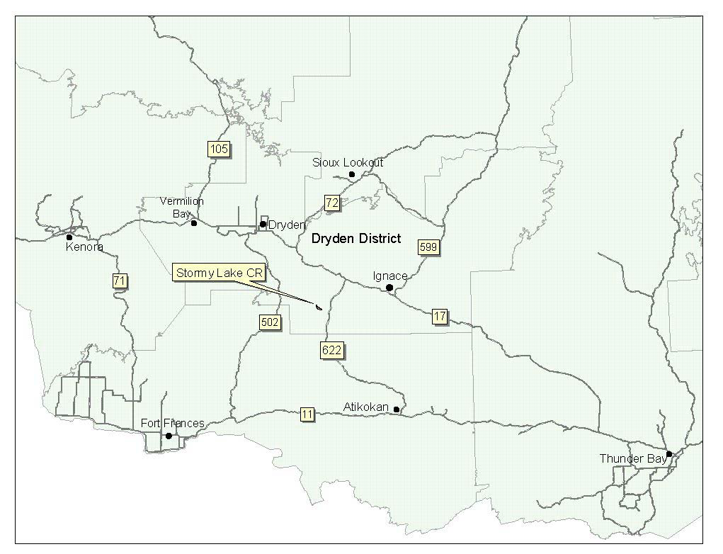
Figure 1: General location of the Stormy Lake Conservation Reserve.

Enlarge Figure 1: General location of the Stormy Lake Conservation Reserve map.
2.0 Values to be protected
This section provides a description of the key natural heritage values on the site, their condition relative to past resource and management activities, and their sensitivity to future land use and management activities.
Table 2.1: Values identified on the Stormy Lake Conservation Reserve.
| Life Science | Old-growth cedar (> 114 years), and red and white pine (~ 155 years) |
|---|---|
| Earth Science | No significant earth science values |
| Cultural | N/A |
| Aboriginal | N/A |
| Tourism | Stormy Lake Camp (opposite the reserve on Stormy lake) and a couple of boat caches |
| Recreational Fishing |
|
| Recreational Hunting |
|
| Trapping |
|
| Bear Management Area |
|
| Bait Harvesting |
|
| Commercial Fishing | N/A |
2.2 Values to be protected
The intent of this SCI is to protect the following values by establishing management guidelines for existing and potential uses in this area given the level of past disturbance and the nature of the existing features.
2.2.1 Forest values
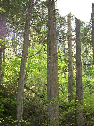
The reserve consists largely of old- growth cedar, which extend to the northeast of the reserve along the east side of Stormy Lake. These range from 114 to 162 years of age. Scattered old-growth red and white pine (~155 years) can be found throughout the reserve as well. (Foster et al., 2002) The site itself was considered provincially significant (Noble, 1995).
2.2.2 Biological values
No species of herbaceous plant or animal found on the reserve were deemed significant. Some of the mixedwood forest did contain an abundance of moose browse. A high quality moose aquatic feeding area exists on the small waterbody forming the southeastern boundary of the reserve. As well, an osprey nest was recorded in the reserve and 3 bald eagles nests exist within 1200 m of the reserve. (Foster et al., 2002).
Stormy Lake, adjacent to the reserve, is a popular lake trout fishery. It is utilized in both the summer and winter months. Other species of interest in the lake include northern pike, walleye, lake whitefish, burbot, rock bass, yellow perch and cisco.
2.2.3 Landform values
No significant earth science values exist within the conservation reserve.
2.2.4 Recreational values
The Stormy Lake CR Recreation Inventory concluded that the coniferous trees (primarily cedar and white pine), the small lakes within the reserve, the inhabiting large land mammals and the existing trail through the west side to be of recreational value. Stormy Lake itself was considered to be a valued recreation feature also even though it is not contained within the reserve. Current activities include fishing, however this would occur on Stormy Lake and not within the reserve itself. Trapping also occurs on and around the reserve. Proposed activities include hunting, big tree observation, and portaging. It was determined that none of the recreation features would be sensitive to recreation use.
2.2.5 Tourism values
A tourist lodge and a couple of commercial boat caches reside on Stormy Lake, however, are not located within the reserve. As well, a lodge and several boat caches can be found on and around Long Lake, directly north of Stormy.
3.0 Management guidelines
3.1 Land tenure
The Stormy Lake Conservation Reserve consists of and is surrounded entirely by Crown land.
Figure 2: Old-growth cedar within the reserve.
The reserve will remain Crown land and no dispositions (including Land Use Permits or Licenses of Occupation) will be issued for the site.
The disposition of adjacent Crown Land will be dealt with on a case-by-case basis.
Unauthorized occupations of lands within the conservation reserve will be handled in accordance with approved policy, and any required structural removal will be at the owner’s expense.
3.2 Existing and proposed development
There is no existing development within the Stormy Lake Conservation Reserve. The reserve is located approximately 15.5 km from the closest public boat launch and 8 km from a tourist lodge on Stormy Lake. An active gravel pit exists approximately 3.75 km northeast of the reserve. Several tertiary roads exist around Stormy Lake, the closest of which is approximately 900 m from the reserve. There are some timber harvest blocks to the east and southeast of the reserve scheduled to be harvested within the next 5 years (2003 – 2008).
Facility infrastructure and development for recreational and/or educational purposes may be considered in the future if there is a demonstrated demand for such facilities. All provincial policies that guide development on Crown Land are applicable in Conservation Reserves. A more detailed management plan would be required prior to any development occurring. Such a plan would have to ensure that there would be no negative impacts to any habitat or ecosystem pertinent to the values protected in this reserve.
3.3 Recreational Activities
Most recreational activities that have traditionally been enjoyed in this area can continue provided they pose no threat to the natural ecosystems and features protected by the Conservation Reserve. Those uses that are regulated include hunting, fishing and trapping. Most other permitted activities are non-regulated (i.e. canoeing, exploring). See Section 2.2.4 for the recreational uses for this Conservation Reserve as determined by the Recreation Resource Inventory.
Mechanical travel within the reserve, including the use of snowmobiles and All Terrain Vehicles, is permitted only on existing roads and trails. Off trail mechanized travel is permitted for retrieval of game only.
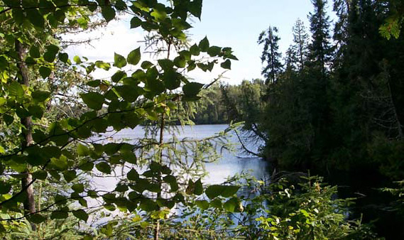
Figure 3: View through the bush of the small lake within the reserve
3.4 Commercial activities
No new activities, such as commercial logging, hydroelectric power development, new transmission lines (e.g. power or communications), pipelines, highways or roads, and the extraction of minerals, aggregate or peat will be permitted.
Stormy Lake was last licensed for a Native commercial fishery in 1993. The primary species harvested was whitefish.
An examination of the possible impact of activities on adjacent lands should be evaluated in the Forest Management Plan.
3.5 Aboriginal interests
To date, no Aboriginal Groups have voiced any issues in regards to this conservation reserve. Nothing in this Statement of Conservation Interest affects in any way existing or future Aboriginal or treaty rights.
3.6 Natural resources stewardship
Natural Resource Stewardship involves the consideration of the following specific natural resource management categories.
3.6.1 Vegetation management
Management within the Conservation Reserve will allow for the continuation of natural ecosystem processes and functions with minimal human interference.
Forest fire suppression will be carried out in accordance with the approved Fire Management Strategy for the surrounding lands. "Light on the Land" suppression techniques which do not unduly disturb the landscape will be encouraged where feasible. Examples of "light on the land" techniques may include limiting the number of trees felled or the use of heavy equipment or foam.
Opportunities for prescribed burning to achieve ecological or resource management objectives may be considered. These management objectives will be developed with public consultation prior to any prescribed burning, and reflected in the document that provides management direction for this conservation reserve. Plans for any prescribed burning will be developed in accordance with the MNR Prescribed Burn Planning Manual, and the Class Environmental Assessment for Provincial Parks and Conservation Reserves (approval pending).
Forest insect and disease management will continue as on surrounding Crown lands.
3.6.2 Fish and Wildlife Management
The existing Wildlife Management Unit, sport fishing regulations and management activities will apply.
3.6.3 Landforms
None of the landforms mentioned will be altered by landform modification activities such as filling and extraction. The extraction of aggregates and similar materials are not permitted.
Mineral exploration and extraction are not permitted.
3.7 Cultural Resources Stewardship
To date, there have been no surveys done to assess cultural or heritage values. However, common knowledge of the area suggests there to be no such values on this site, thus Cultural Inventories were deemed unnecessary.
3.8 Client Services
Given the focus on low key management, client information will be given on an inquiry basis only and will deal with the basic level of information with respect to access, natural heritage appreciation, recommended activities and boundaries.
3.9 Research
Non-destructive research by qualified individuals will be encouraged to provide a better understanding of the natural values protected by the Conservation Reserve and to advance protection, planning and management.
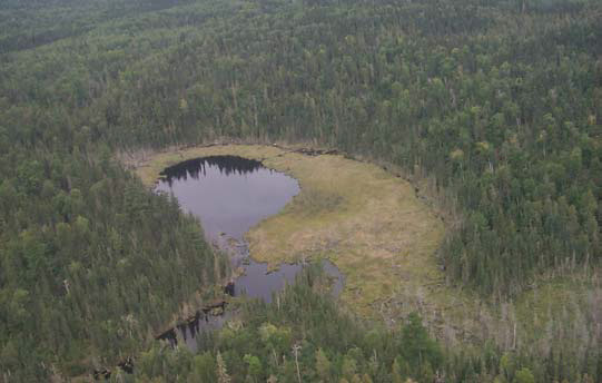
Figure 4: Aerial view of one of the beaver ponds found within the reserve.
In order to assist with enhancing the management guidelines for the reserve, the collection of additional earth and life science information during research is encouraged.
All research programs will require the approval of the Ministry of Natural Resources as will the removal of any natural or cultural specimen. The establishment of permanent plots, observation points or facilities must also be approved and be compatible with the Conservation Reserve protection objective. Any site disturbed by research activities must be rehabilitated as closely as possible to its previous state.
3.10 Marketing
Awareness of the Conservation Reserve is promoted through the Living Legacy web site. Intensive management activity to increase use is not required at this time.
4.0 Implementation
Implementation of this Statement of Conservation Interest will primarily involve monitoring activities to ensure adherence to the management guidelines and responding to inquiries about the site.
Implementation of this statement and management of the reserve are the responsibility of the Wabigoon Area Supervisor. Partnerships may be pursued to address management needs.
5.0 Review and revisions
5.1 Review and revisions
This Conservation Reserve Statement of Conservation Interest will be reviewed on an ongoing basis.
If changes in management direction are needed at any time, the significance of the changes will be evaluated and further consultation a possibility. Any major amendments will require full public consultation and the approval of the District Manager and Regional Director. Affected clients will be immediately informed of proposed changes to this Statement of Conservation Interest.
5.2 Public consultation
5.2.1 Results of past consultations
Consultation on the Stormy Lake Conservation Reserve was conducted as part of the consultation on the Ontario’s Living Legacy Land Use Strategy, July 1999. Subsequent consultation also took place in June 2001 to refine the boundary of the Conservation Reserve.
District Manager letters, totaling 91, were sent to the Dryden Forest Management Co., Weyerhaeuser and Ontario’s Forest Industries Association, Tourist Outfitters, Advisory Committees, Trappers, Land Owners, Members of the Public, Non-Government Organizations and Government Organizations. Newspaper ads were placed in the Ignace Driftwood June 20, 2001 and Dryden Observer on June 19, 2001.
First Nation Consultation letters were also sent to ten Native communities including the Wabigoon Lake Ojibway Nation and Aboriginal People of Wabigoon. Direct consultation with Treaty 3 First Nations was carried out on a regional basis and concluded November of 2002.
Two responses were received from stakeholders concerning general permitted uses. These issues were clarified during the consultation process. No further specific issues have been voiced to date. No responses have been received to date from any of the First Nations groups.
5.2.2 Present and future consultation
More widespread consultation is deemed unnecessary at this time.
5.2.3 Author
This Statement of Conservation Interest was prepared by Alicia H.L. Morin, OLL Intern, Information Management, Dryden District. Assistance was provided by Martin Pell (Dryden District Planner) and members of the Wabigoon Area Team.
6.0 References
Blackburn, C. 2002. Earth Science Inventory – Stormy Lake Conservation Reserve. Unpublished report for Northwest Region MNR, Thunder Bay, ON.
Foster, R and Harris, A. 2002. Life Science Inventory – Stormy Lake Conservation Reserve. Unpublished report for Northwest Region MNR, Thunder Bay, ON.
Noble, T. 1995. Site District 4S5 gap analysis. Unpublished report for Northwest Region MNR, Thunder Bay, ON. p. 21 + Append.
Ontario Ministry of Natural Resources (OMNR). 1999. Ontario’s Living Legacy Land Use Strategy. p. 24. Queen’s Printer for Ontario.
Ontario Ministry of Natural Resources (OMNR). 2002. Stormy Lake Conservation Reserve (C2292) Recreation Resource Inventory Report. Unpublished report.
Ontario Ministry of Natural Resources (OMNR). Lands & Natural Heritage, Lands & Waters. 1997. Conservation Reserve Policy and Procedure PL 3.03.05.
Appendix A: Stormy Lake Conservation Reserve (C2313)
Values map
Stormy Lake Conservation Reserve (C2313) - Values Map
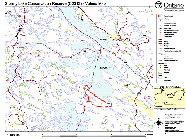
Enlarge Stormy Lake Conservation Reserve (C2313) - Values Map.
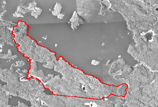
Appendix B: Stormy Lake Conservation Reserve (C2313)
Aerial photo image
Appendix C: Stormy Lake Conservation Reserve (C2313)
Earth science checksheet
Detailed information for site C2313 Stormy Lake
Protection history
The reserve was identified under the provincial Lands for Life - Ontario’s Living Legacy Program as containing "upland and lowland old growth cedar." (OMNR 1999).
No previous earth science significance was assigned.
Setting
The reserve comprises 412 hectares, all located in Dryden MNR District.
Earth science features
Bedrock geology
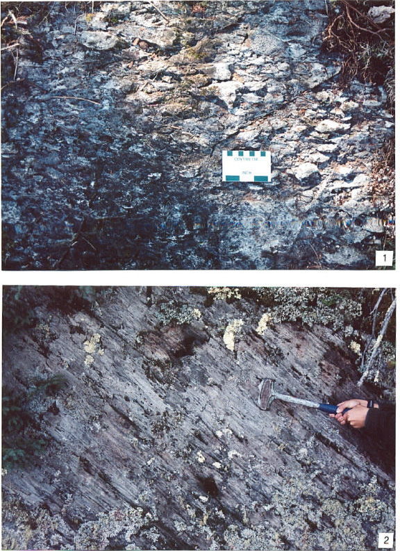
This small reserve is underlain entirely by Archean age volcanic rocks of the Wabigoon Subprovince, in the western greenstone-belt dominated region (Blackburn et al 1991, p.305). It is located in the Manitou - Stormy lakes greenstone belt at its eastern end (Blackburn et al 1991: Figure 9.8), and straddles the contact between mafic volcanic rocks of the Wapageisi group and overlying pyroclastic rocks at the base of the mixed pyroclastic-sedimentary Stormy Lake group. Although the only detailed government geological map of this immediate area dates from the 1930s (Thomson 1933), lithologies of these two groups have been determined in detailed mapping of the Manitou Lakes portion of the greenstone belt further to the west (Blackburn 1982).
The pyroclastic rocks are the most easily accessible, since they are well exposed along the south shoreline of Stormy Lake. During the present reconnaissance they were observed at seven stations along the shoreline, and at two stations inland in close proximity to the contact with the underlying mafic volcanic rocks of the Wapageisi group. There is little variation in rock type. At all stations coarse fragmental pyroclastic rocks varying from lapilli-tuff to tuff-breccia have been sheared to varying degrees; at station 6 at the northwest end of the shoreline they are relatively undeformed and pyroclastic fragments are easily recognisable (photo 1); at station 2 at the southeast end, they are highly deformed, with clasts stretched out in the foliation plane that dips steeply to the south (photo 2). Also, alteration varies from development of iron carbonate and chlorite at station 6 to silicification in the strongly sheared rocks at station 2.
Mafic volcanics of the Wapageisi group were observed at one station only, in close proximity to the contact with pyroclastic rocks (station 10). Here it varies from fine to coarse grained and generally massive, though vague outlines of pillow rims were observed in the finer basaltic rock. At this point a topographic low follows the contact, and the basalts rise up as a 20 m high cliff on the south side of the valley. The contact passes to the southeast along the north shore of a small inland lake, and thence out of the southeast end of the reserve at the west end of another small lake.
Surficial geology
Quaternary deposits are limited to Pleistocene age till over bedrock (Cowan and Sharpe 1991; Roed 1980). The reserve lies in a predominantly upland area between the Hartman and Eagle-Finlayson end moraines.
Significance
The Stormy Lake Conservation Reserve is of little significance to the earth science conservation program since volcanic rock bedrock is minimally exposed and shows no striking features that would make it stand out from other larger and better exposed reserved lands. The till is equally undistinguished.
Sensitivity
Neither the bedrock nor the surficial earth science features are subject to degradation by human activity or by natural processes.
Recommendations
No recommendations are made.
References
Blackburn, C.E. 1982. Geology of the Manitou lakes area, District of Kenora (stratigraphy and petrochemistry); Ontario Geological Survey, Report 223, 61 p. Accompanied by Map 2476, scale 1:50 000.
Cowan, W.R. and Sharpe, D.R. 1991. Surficial Geology, Gold Rock, Ontario; Geological Survey of Canada, Map 1775A, scale 1:100 000.
OMNR 1999. Ontario’s Living Legacy: Land Use Strategy; Ontario Ministry of Natural Resources, 136 p., accompanied by map, scale 1:1 200 000.
Roed, M.A. 1980. Northern Ontario Engineering Geology Terrain Study, Data Base Map, Gold Rock; Ontario Geological Survey, Map 5061, scale 1:100 000.
Thomson, J.E. 1933. Manitou-Stormy Lakes Area; Ontario Geological Survey, Map 42c, scale 1:63 360.
Photographs
- Carbonatized and chloritized lapilli-tuff, weakly South shore of Stormy Lake. (Stn. 6; UTM 0550130E 5567407N)
- Sheared and silicified lapilli-tuff, with foliation dipping at 80° to the South shoreline of Stormy Lake. (Stn. 2; UTM 0552502E 5465867N)
Additional stations
- Stn. 1 UTM 0552857E 5465897N
- Stn. 3 UTM 0551884E 5466227N
- Stn. 4 UTM 0551140E 5466623N
- Stn. 5 UTM 0550617E 5467100N
- Stn. 7 UTM 0549627E 5467904N
- Stn. 8 UTM 0550472E 5466503N
- Stn. 9 UTM 0550320E 5466574N
- Stn. 10 UTM 0549935E 5466782N
Earth science inventory checklist
Table: Earth science inventory checklist
| Name: | Stormy Lake |
|---|---|
| OLL ID: | C2313 |
| Map name: | Stormy Lake |
| NTS number: | 52F/08 |
| UTM reference: | Z15 551000E 546 |
| OBM number: | |
| Latitude: | 49° 21' N |
| Longitude: | 92° 18' W |
| Elevation – max: | 450 m |
| Elevation – min: | 390 m |
| County: | District of Kenora |
| Township: | unorganized |
| Lot: | N/A |
| Concession: | N/A |
| Area (ha): | 214.00 |
| Ownership: | Crown |
| Air photo: | |
| Year: | 1997 |
| Roll: | 53 |
| Flight line: | 4912B |
| Number: | 222, 223 |
| MNR Region: | Northwest |
| MNR District: | Dryden |
| Park Zone: | Northwest |
Map - Earth science inventory location map.
Earth Science Features:
Archean age, Wabigoon Subprovince: entire reserve is underlain by metavolcanic felsic pyroclastic and mafic flow rocks of the Manitou-Stormy lakes greenstone belt.
Quaternary: deposits are predominantly shallow till over bedrock.
Significance
Because of the very limited size and exposure, no significance is given to bedrock or surficial geological features.
Sensitivity
Neither bedrock nor surficial features are sensitive to natural or cultural impacts.
Recommendations
No recommendations are made.
Major references
Cowan and Sharpe 1991, GSC Map 1775A; Roed 1980, OGS Map 5061; Thomson 1933, OGS Map 42c.
Date compiled
February 15, 2003
Compiler
C.E. Blackburn, Blackburn Geological Services
Appendix D: Stormy Lake Conservation Reserve (C2313)
Life Science Checksheet
Natural Heritage Area – Life Science Checksheet
| Name: | Stormy Lake |
|---|---|
| Map name: | Stormy Lake |
| Map number: | 52F/8 |
| UTM reference: | Zone 15 551000 E 5466000 N |
| Latitude: | 49° 21' N |
| Longitude: | 92° 18' W |
| NAD | 83 |
| Min. Alt.: | 390 m |
| Max. Alt.: | 450 m |
| County: | Kenora |
| Locality: | 60 km SE of Dryden |
| Township: | unorganized |
| Area: | 412 ha |
| Ownership: | Crown |
| MNR Region: | Northwest |
| Ecoregion and Ecodistrict: | 4S-5 |
| Landform unit: | See Table 3 |
| MNR District: | Dryden |
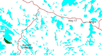
| Air photographs: | Hwy 622 to Atikokan |
| Year: | 1997 |
| Roll: | 4912 |
| Flight: | B |
| Line: | 53 |
| Number: | 222 to 223 |
Map - Natural Heritage Area – Life Science
Physical and biological features
C2313 is located on the southern shore of Stormy Lake, a deep, 3500 ha coldwater lake (Map 1). The reserve does not include any of Stormy Lake, but it does encompass a small (23 ha) lake and two small beaver ponds (<1 ha). In the east of the reserve, the beaver pond drains into Stormy Lake via an intermittent stream. A small (~70 ha) lake also forms part of the reserve boundary in the southwest. Although there are only about 60 m of total elevational difference in the reserve, steep slopes are found on the north side of the southeast-northwest trending ridge that runs through the reserve (Photo 1).
Cedar-dominated forests comprise over 40% of the reserve, and are found on a variety of sites. Upland cedar stands on coarse to fine loamy soils (ES17) make up 37% of the reserve (Table 1). On cool, damp, north-facing slopes, there is heavy conifer litter and little herbaceous ground cover. The slopes have abundant colluvial material and the ground surface is scoured in places by spring surface runoff. Cedar mixedwoods with white birch and white spruce are found on mid and upper slopes (Photo 2). Drier uplands have increasing large-leaved aster, jack pine, and black spruce. Wild rose, club mosses, blueberries, creeping snowberry, and reindeer lichens are typical understorey species. There are some old growth cedar stands but most (~2/3) are 85 to 90 years of age and likely of fire origin.
Aspen-dominated mixedwoods with balsam fir and spruce (ES19) make up ~1/5 of the reserve. Overstorey aspen are often large (30 cm DBH), and there is a dense shrub layer with beaked hazel, bush honeysuckle, and balsam fir (Photo 3). White pine mixedwoods (ES18) are found principally in the western portion of the reserve and in small patches along the shoreline of Stormy Lake (Photo 4).
Wetlands make up about 10% of the reserve and include rich cedar swamps (ES37) as well as open wetlands. Meadow marshes (W12) are typically dominated by beaked sedge, lake sedge, jewelweed, water hemlock, and wild raspberry. Semi-floating, wire sedge shore fens (W14) are also associated with beaver ponds in the reserve (Photo 5).
On the northern shore of the reserve, a large north-and east-facing cliff is densely wooded along its base, with pin cherry, common juniper, fragrant cliff fern, bluegrasses, and Richardson’s alumroot along the face.
Representation
Table 3 summarizes representation of landform vegetation types of the Stormy Lake Conservation Reserve for Ecodistrict 4S-5 as recently refined by Ontario Parks (Steve Kingston pers. comm.). An older version of the landform vegetation representation matrix based on the original Ontario Living Legacy gap analysis is included for comparison (Table 4). The landform was considered ground moraine in the original OLL analysis; however in the revised analysis, which is based on the Quaternary Geology of Ontario (ERLIS Data Set 14), the reserve is considered bedrock. Reconnaissance fieldwork indicated that much of the reserve is ground moraine over bedrock, with at least 1 m of till at most locations. Since the Quaternary Geology of Ontario is a compilation at a much coarser scale (1:500,000) it is unclear if the reserve classifies as bedrock or ground moraine for the purposes of representation.
The reserve contributes little to representation targets for bedrock LV-types in the Ecodistrict 4S-5 (Table 3). However, Stormy Lake C.R. does provides excellent representation of cedar-dominated mixed forests on weakly to moderately broken ground moraine over bedrock. Deciduous mixed forests on moderately broken ground moraine are also well represented. The reserve provides little if any representation for pure deciduous forests, since aspen and birch are mixed with conifers. No pure hardwood stands are listed in the FRI or were observed in the field, although small pockets (~1 ha) may be present.
The treed bog LV-type (Table 3) near the small beaver pond is actually approximately 13 ha of misclassified open wetland (shore fen and meadow marsh).
Fieldwork, fire history maps, and aerial photographs show no evidence of recent fires (<80 years old); the reserve does not provide representation for burn LV-types as previously reported in the original OLL analysis (Table 4).
Condition
The conservation reserve is in an essentially undisturbed condition, primarily due to its remote location. It is a 15 km boat ride from the nearest boat launch. The nearest tertiary road is approximately 900 m from the reserve and there is no active logging nearby. There are no permanent structures (e.g. buildings) within the reserve.
There are several commercial and private boat caches on Stormy Lake. It is used for fishing and waterfowl hunting. Stormy is a popular angling lake. It has lake trout, northern pike, walleye, lake whitefish, burbot, rock bass, yellow perch, shorthead redhorse, cisco, and white sucker.
The conservation reserve encompasses one baitfish block and two bear management areas (BMAs).
Diversity
On the landform-vegetation type scale, the Stormy Lake Conservation Reserve has relatively low diversity due to its small size and relatively uniform parent material. A total of 6 LV types (Table 4) and 12 Ecosites (Table 1) are represented. The broken topography provides for a relatively good diversity of cedar-dominated forests however. The lakes and beaver ponds in the reserve (Photo 6) add to the diversity of the site, as does adjacent Stormy Lake.
Ecological considerations
Beaver activity has significant impacts on vegetation communities along streams and beaver ponds due to hydrological impacts and selective foraging. Spruce budworm outbreaks occurred in the reserve in 1988 and 1989 resulting in some mortality of white spruce and balsam fir. There is abundant moose browse in some of the mixedwood stands.
Special features
There are 33 ha of upland old growth cedar (ES17; 162 years) and 24 ha of old growth cedar swamp (ES37, 143 years). There are old cedars in mixedwood stands as well; once 60 cm DBH cedar that was cored during fieldwork was 150+ years. There are no old growth stands of red or white pine in the reserve but there are individual old trees; a 90 cm DBH white pine was 155+ years and 70 cm DBH red pine was observed in the field.
An osprey nest is recorded from the northeast corner of the reserve but could not be located in the field. Three eagle nests are located within 1200 m of the reserve on Stormy Lake. They may forage along the shoreline or waterbodies of the reserve.
There is a high quality moose aquatic feeding area on the small waterbody forming part of the reserve’s southeastern boundary. The abundant shrub layer provides high quality browse in some of the mixedwood stands in the reserve.
Recommendations
None
Significance level and summary of major representative values
The reserve is provincially significant for its representation of conifer (particularly old growth cedar) and deciduous mixedwoods on weakly and moderately broken ground moraine in 4S-5. The site was considered provincially significant by Noble (1995).
Major information sources
Harris, A.G., S.C.McMurray, P.W.C.Uhlig, J.K.Jeglum, R.F.Foster and G.D. Racey. 1996. Field guide to the wetland ecosystem classification for northwestern Ontario. Ont. Min. Natur. Resour., Northwest Sci. & Technol. Thunder Bay, Ont. Field Guide FG-01. 74 pp. + Append.
Noble, T. 1995. Site District 4S5 gap analysis. Unpublished report for Northwest Region, Ont. Min. Natur. Resour., Thunder Bay, Ont. 21 p + Append.
OMNR. 1999. Ontario’s Living Legacy – Land Use Strategy. Queen’s Printer, Toronto.
Racey, G.D., A.G. Harris, J.K.Jeglum, R.F.Foster and G.M.Wickware. 1996. Terrestrial and wetland ecosites of northwestern Ontario. Ont. Min. Natur. Resour., Northwest Sci. & Technol. Thunder Bay, Ont. Field Guide FG-02. 88 pp. + Append.
Sims, R.A., W.D. Towill, K.A. Baldwin, P. Uhlig and G.M. Wickware. 1997. Field guide to the forested ecosystem classification for northwestern Ontario. Ont. Min. Natur. Resour., Northwest Sci. & Technol. Thunder Bay, Ont. Field Guide FG-03. 176 p.
Uhlig, P., A. Harris, G. Craig, C. Bowling, B. Chambers, B. Naylor and G. Beemer. 2001. Old growth definitions for Ontario. Ont. Min. Nat. Res., Queen’s Printer for Ontario, Toronto, ON. 27 p.
| Date Compiled | Compiler(s) |
|---|---|
| 21/05/03 | Robert Foster, Allan Harris Northern Bioscience |
Map 1. Site map with significant features.

Enlarge Map 1. Site map with significant features.
Photo 1. View of conservation reserve looking west along Stormy Lake.
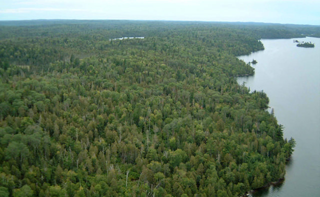
Photo 2. White pine mixedwoods are found along the shoreline of Stormy Lake.
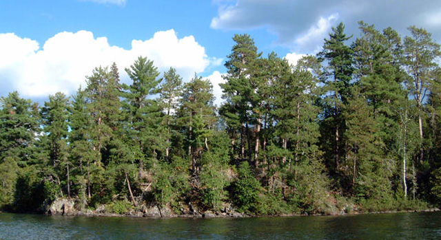
Photo 3. Cedar stand with mountain maple understorey.
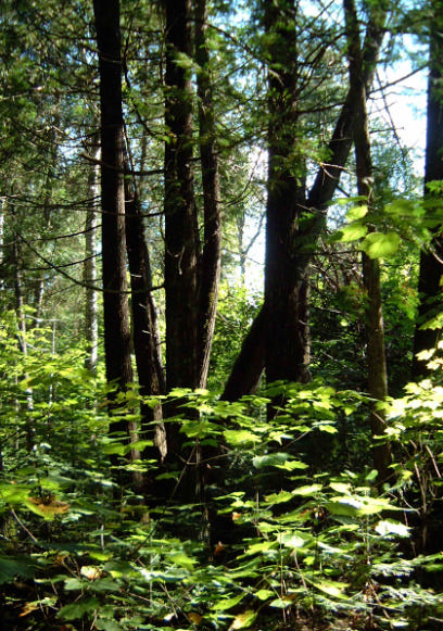
Photo 4. Upland aspen mixedwood with abundant balsam fir regeneration.
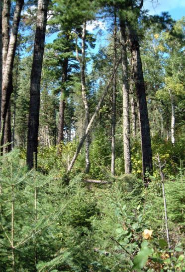
Photo 5. Small beaver pond with shore fen within reserve.
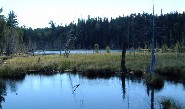
Photo 6. Small, unnamed lake within Stormy Lake Conservation Reserve.
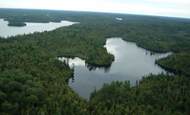
Table 1. Terrestrial ecosites of Stormy Lake (derived from Forest Resource Inventory data provided by OMNR).
Very Shallow Soils
| Description | Area (ha) | Proportion(%)* |
|---|---|---|
| ES12 Black Spruce - Jack Pine: Very Shallow Soil | 4 | 1 |
Sandy - Coarse Loamy Soils
| Description | Area (ha) | Proportion(%)* |
|---|---|---|
| ES17 White Cedar: Fresh - Moist, Coarse - Fine Loamy Soil | 152 | 37 |
| ES18 Red Pine - White Pine: Fresh, Coarse Loamy Soil | 29 | 7 |
| ES19 Hardwood - Fir - Spruce Mixedwood: Fresh, Sandy - Coarse Loamy Soil | 88 | 21 |
| ES20 Spruce - Pine / Feathermoss: Fresh, Sandy - Coarse Loamy Soil | 47 | 11 |
| ES21 Spruce - Fir Mixedwood: Fresh, Coarse Loamy Soil | 26 | 6 |
| ES22 Spruce-Pine / Ledum / Feathermoss: Moist, Sandy-Coarse Loamy Soil | <1 | <1 |
Treed Wetlands
| Description | Area (ha) | Proportion(%)* |
|---|---|---|
| ES37 Rich Swamp: Cedar (Other Conifer): Organic Soil | 54 | 4 |
Open Wetlands**
| Description | Area (ha) | Proportion(%)* |
|---|---|---|
| ES40 Treed Fen
MNR Code 310 - Treed Muskeg |
4 | 2 |
| ES41 Other open wetlands (i.e., fens, shore fens, meadow marshes, marshes) ES46-48 MNR Codes 311 - Open Muskeg |
13 | 3 |
| Open Water
MNR Code 64 – Lake |
26 | 6 |
| Unclassified or Other | 39 | 3 |
* proportion of reserve
** approximated from MNR Code; ecosites not directly interpreted for these polygons.
Table 2. Rapid assessment plot summary from Stormy Lake.
| Plot No. | V / W Type | ES Type | Date |
|---|---|---|---|
| 404 | V21 | ES27 | 2002/09/10 |
| 405 | V16 | ES17 | 2002/09/10 |
| 406 | W12 | ES46 | 2002/09/10 |
| 407 | V19 | ES18 | 2002/09/10 |
| 408 | V21 | ES17/19 | 2002/09/10 |
Table 3. Landform – vegetation (LV) type representation for Stormy Lake Conservation Reserve for Ecodistrict 4S-5 (derived from analysis by Ontario Parks; Steve Kingston pers. comm.).*.
| LV_Description | Ecodistrict - Area (ha) | Ecodistrict - Representation Target % | Ecodistrict - Representation Target ha | Ecodistrict - Protected Areas (ha) | Stormy Lake - Area (ha) | Stormy Lake - Contribution to Ecodistrict Target (%) | Stormy Lake - Contribution to Existing Protection (%) | Stormy Lake - Confirmed in Field**. |
|---|---|---|---|---|---|---|---|---|
| Bedrock-Mixed Forest – mainly Coniferous | 237,440 | 12 | 28,493 | 18,258 | 289 | 1 | 2 | X |
| Bedrock-Dense Coniferous Forest | 145,337 | 12 | 17,440 | 9,212 | 20 | 0 | 0 | X |
| Bedrock-Sparse Coniferous Forest | 123,461 | 12 | 14,815 | 10,279 | 4 | 0 | 0 | X |
| Bedrock-Dense Deciduous Forest | 81,951 | 12 | 9,834 | 5,010 | 2 | 0 | 0 | |
| Bedrock-Sparse Deciduous Forest | 44,792 | 12 | 5,375 | 1,662 | 2 | 0 | 0 | |
| Bedrock-Mixed Forest – mainly Deciduous | 40,181 | 12 | 4,822 | 3,229 | 38 | 1 | 1 | X |
| Bedrock-Treed Bog | 13,217 | 12 | 1,586 | 845 | 2 | 0 | 0 | |
| Bedrock-Treed Fen | 3,994 | 13 | 524 | 535 | 6 | 1 | 1 | X |
*.The LV matrix was recently refined by Ontario Parks in several ways: 1) revised Ecodistrict boundaries; 2) increased resolution of Landcover28 data (25 m vs. 100 m); 3) terrain is no longer used as a modifier; 4) more accurate surficial geology data; and 5) updated approach to representation targets.
**.all LV types were on ground moraine over bedrock, with >1 m of till at most locations, and should probably be considered till rather than bedrock
Table 4. Original version of landform – vegetation (LV) type representation for Stormy Lake Conservation Reserve used in Ontario Living Legacy gap analysis.
| Site District | Landform | Surface Expression | burn | conifer mixed | deciduous | deciduous mixed | sparse forest | Grand Total |
|---|---|---|---|---|---|---|---|---|
| 4S-5 | Ground Moraine | Moderately Broken | 1 | 95R | 33R | 15R | 144 | |
| Weakly Broken | 5R | 28R | 1R | 3 | 37 | |||
| Grand Total | 6 | 123 | 1 | 36 | 15 | 181 |
C = critical to meet representation targets at the Site District level
R = contributes to representation of the LV type at the Site District level
Table 5. Site type matrix for Stormy Lake with representative ecosites (Racey et al. 1996).
| Arid | Very Dry | Dry | Dry Mesic | Mesic | Wet Mesic | Wet | Very Wet | Saturated | Open Water | |
|---|---|---|---|---|---|---|---|---|---|---|
| Colder - Rock | ||||||||||
| Colder - Sand | ||||||||||
| Colder - Loam | ||||||||||
| Colder - Clay | ||||||||||
| Colder - Organic | ES37 | ES37, ES40, ES41, |
||||||||
| Normal - Rock | ES4 | ES12 | ||||||||
| Normal - Sand | ES19, ES20 |
|||||||||
| Normal - Loam | ES17, ES18, ES21 |
ES17, ES18, ES19, ES21 |
ES17, ES19 |
ES17, ES19, ES22 |
ES17
ES17 |
ES17
ES17 |
ES45, ES46 |
ES47 | ||
| Normal - Clay | ||||||||||
| Normal - Organic | ||||||||||
| Warmer - Rock | ||||||||||
| Warmer - Sand | ||||||||||
| Warmer - Loam | ||||||||||
| Warmer - Clay | ||||||||||
| Warmer - Organic |
Stormy Lake species lists
The following species lists are based fieldwork conducted September 10, 2002 and data provided by OMNR.
Plant list
Taxonomic order and species names generally follow Morton and Venn (1990). Introduced species are marked "I". Provincially rare species (Oldham 1999) are marked "P". Regionally rare species (TBFN 1998) are marked "R". Voucher specimens were collected for species marked ".*".
| Family Equisetaceae | Equisetum sylvaticum L. |
|---|---|
| Horsetail Family | Woodland Horsetail |
| Family Dennstaetiaceae | Pteridium aquilinum (L.) Kuhn |
| Bracken Family | Bracken |
| Family Dryopteridaceae | .* Dryopteris fragrans (L.) Schott |
| True Fern Family | Fragrant Cliff Fern |
| Family Osmundaceae | Osmunda claytoniana L. |
| Flowering Fern | Interrupted Fern |
| Family Thelypteridaceae | Phegopteris connectilis (Michaux) Watt Thelypteris palustris (Salisb.) Schott |
| Marsh Fern Family | Long Beech Fern Marsh Fern |
| Family Lycopodiaceae | Huperzia lucidula (Michx.) Trevis. Lycopodium clavatum L. Lycopodium complanatum L. |
| Clubmoss Family | Shining Fir-moss Common Clubmoss Ground Cedar |
| Family Cupressaceae | Juniperus communis L. Thuja occidentalis L. |
| Juniper Family | Common Ground Juniper Eastern White Cedar |
| Family Pinaceae | Abies balsamea (L.) Miller Picea glauca (Moench) Voss Picea mariana (Miller) BSP Pinus banksiana Lambert Pinus resinosa Sol. ex Aiton Pinus strobus L. |
| Pine Family | Balsam Fir White Spruce Black Spruce Jack Pine Red Pine White Pine |
| Family Taxaceae | Taxus canadensis Marshall |
| Yew Family | Canada Yew |
| Family Alismataceae | Sagittaria rigida Pursh |
| Water Plantain Family | Stiff Arrowhead |
| Family Cyperaceae | .* Carex disperma Dewey Carex gynocrates Wormskj. ex Drejer Carex lacustris Willd. Carex lasiocarpa Ehrh. Carex stricta Lam. Carex trisperma Dewey Carex utriculata Boott Carex viridula Michaux Dulichium arundinaceum (L.) Britton Eleocharis acicularis (L.) Roemer & Schultes Scirpus cyperinus (L.) Kunth |
| Sedge Family | Two-seeded Sedge Ridged Sedge Lake Sedge Wire Sedge Tussock Sedge Three-fruited Sedge Beaked Sedge Greenish Sedge Three-way Sedge Needle Spikerush Black-sheathed Bulrush |
| Family Iridaceae | Iris versicolor L. |
| Iris Family | Wild Iris |
| Family Poaceae | Calamagrostis canadensis (Michaux ) P.Beauv. Glyceria borealis (Nash) Batch. .* Poa pratensis L. |
| Grass Family | Bluejoint Grass Northern Manna Grass Kentucky Blue Grass |
| Family Potamogetonaceae | Potamogeton natans L. |
| Pondweed Family | Floating-leaved Pondweed |
| Family Sparganiaceae | Sparganium fluctuans (Morong) Robinson |
| Bur-Reed Family | Floating Bur-reed |
| Family Typhaceae | Typha angustifolia L. |
| Cattail Family | Narrow-leaved Cattail |
| Family Aceraceae | Acer spicatum Lam. |
| Maple Family | Mountain Maple |
| Family Apiaceae | Cicuta bulbifera L. Sium suave Walter |
| Parsley Family | Bulblet-bearing Water Hemlock Water Parsnip |
| Family Apocynaceae | Apocynum androsaemifolium L. |
| Dogbane Family | Spreading Dog Bane |
| Family Asteraceae | Anaphalis margaritacea (L.) Benth. & Hook. f.ex C.B. Clarke Aster macrophyllus L. Bidens cernua L. Eupatorium maculatum L. Petasites frigidus (L.) Fries |
| Sunflower Family | Pearly Everlasting Large-leaved Aster Nodding Beggarticks Joe Pye Weed Sweet Coltsfoot |
| Family Balsaminaceae | Impatiens capensis Meerb. |
| Touch-Me-Not Family | Jewel Weed |
| Family Betulaceae | Alnus incana (L.) Moench Alnus viridis (Chaix) DC. Betula papyrifera Marshall Corylus cornuta Marshall |
| Birch Family | Speckled Alder Green Alder White Birch Beaked Hazelnut |
| Family Brassicaceae | Cardamine pensylvanica Muhlenb.ex Willd. |
| Mustard Family | Pennsylvania Bitter Cress |
| Family Callitrichaceae | Callitriche hermaphroditica L. |
| Water Starwort | Submerged Water Starwort |
| Family Campanulaceae | Campanula aparinoides Pursh |
| Harebell Family | Marsh Bellflower |
| Family Caprifoliaceae | Diervilla lonicera Miller Lonicera dioica L. |
| Honeysuckle Family | Bush Honeysuckle Limber Honeysuckle |
| Family Ericaceae | Chamaedaphne calyculata (L.) Moench Gaultheria hispidula (L.) Muhlenb . ex Bigelow Ledum groenlandicum Oeder Vaccinium angustifolium Aiton Vaccinium myrtilloides Michaux |
| Heath Family | Leatherleaf Creeping Snowberry Labrador Tea Low Blueberry Velvet-leaved Blueberry |
| Family Grossulariaceae | Ribes glandulosum Grauer Ribes oxyacanthoides L. |
| Currant Family | Skunk Currant Bristly Wild Gooseberry |
| Family Guttiferae | Triadenum fraseri (Spach) Gleason |
| St. John’s-wort | Marsh St. Johnswort |
| Family Lamiaceae | Lycopus uniflorus Michaux Stachys palustris L. |
| Mint Family | Northern Bugleweed Woundwort |
| Family Lentibulariaceae | Utricularia intermedia Hayne |
| Bladderwort Family | Flat-leaved Bladderwort |
| Family Myricaceae | Myrica gale L. |
| Bayberry Family | Sweet Gale |
| Family Nymphaeaceae | Nuphar variegata Durand in Clinton |
| Water-lily Family | Yellow Pond Lily |
| Family Onagraceae | Epilobium angustifolium L. Epilobium ciliatum Raf. |
| Evening-primrose | Fireweed Northern Willow Herb |
| Family Polygonaceae | Polygonum amphibium L. Polygonum hydropiperoides Michx. |
| Buckwheat Family | Water Smartweed Mild Smartweed |
| Family Ranunculaceae | Caltha palustris L. |
| Buttercup Family | Marsh Marigold |
| Family Rosaceae | Fragaria vesca L. Potentilla norvegica L. Potentilla palustris (L.) Scop. Prunus pensylvanica L.f. Rosa acicularis Lindley Rubus idaeus L. Spiraea alba Duroi |
| Rose Family | Alpine Strawberry Rough Cinquefoil Marsh Cinquefoil Pincherry Prickly Wild Rose Common Raspberry Narrow-leaved Meadow Sweet |
| Family Salicaceae | Salix pyrifolia Andersson |
| Willow Family | Balsam Willow |
| Family Saxifragaceae | Heuchera richardsonii R.Br. |
| Saxifrage Family | Alum Root |
| Family Urticaceae | Laportea canadensis (L.) Wedd. |
| Nettle Family | Wood Nettle |
Stormy Lake animal species list
Taxonomic order and nomenclature follow AOU (1998) for birds and Banfield (1974) for mammals. Nesting evidence codes follow the Ontario Breeding Bird Atlas:
Possible Nesting
H – Species observed in breeding season in suitable habitat.
S – Singing male present or breeding calls heard observed in breeding season in suitable habitat.
Birds
| Kites, Eagles and Hawks | H Bald Eagle |
|---|---|
| Family Accipitridae | Haliaeetus leucocephalus |
| Sandpipers and Phalaropes | H Spotted Sandpiper Pectoral Sandpiper |
| Family Scolopacidae | Actitis macularia Calidris melanotos |
| Chickadees | H Black-capped Chickadee |
| Family Paridae | Parus atricapillus |
| Nuthatches | S Red-breasted Nuthatch |
| Family Sittidae | Sitta canadensis |
| New World Sparrows | S White-throated Sparrow |
| Family Emberizidae | Zonotrichia albicollis |
Mammals
| Squirrels | Red Squirrel |
|---|---|
| Family Sciuridae | Tamiasciurus hudsonicus |
| Deer | Moose |
| Family Cervidae | Alces alces |
Appendix E: Recreation inventory checksheet
Recreation inventory checklist
| Name: | Stormy Lake Conservation Reserve - C2313 |
|---|---|
| Map name: | Stormy Lake |
| NTS number: | 52 F/8 |
| UTM reference: | 15550767546611 |
| OBM number: | 15540054600, 15550054600 |
| Latitude: | 49° 20' |
| Longitude: | 92° 18' |
| Area (ha): | 412.00 |
| Ownership: | Crown |
| MNR Region: | Northwest |
| MNR District: | Dryden |
| Park Zone: | Northwest |
| County: | N/A |
| Township: | unsurveyed |
| Recreation features: | 1. E03 - Coniferous 2. M02 - Lake, Small 3. W03 - Land Mammals, Large 4. T00 - Trails or Routes, General 5. M02 - Lake, Large |
| Recreation activities: | 1. h01 - Game, Large Mammal 2. H01 - Trapping 3. n01 - Big Tree Observation 4. t13 - Portage 5. F00 - Fishing, General |
| Recreation factors | Features | Rating |
|---|---|---|
| Most Scarce Feature: | N/A | |
| Feature Scarcity: | N/A | |
| Most Unique Feature: | 1 | |
| Activity Attraction Capability: | Low | |
| Scenic Attractiveness: | Moderate | |
| Geographic Significance: | N/A | |
| Feature Significance: | Low | |
| Most Sensitive Feature To Recreation Use: | N/A | |
| Feature Sensitivity To Recreation Use: | N/A | |
| Most Sensitive Feature To Resource Development: | 1 | |
| Feature Sensitivity To Resource Development: | Low | |
| Cultural/Historic and Archaelogical Features: | N/A |
Comments:
2 boats were seen fishing off of Islands on Stormy Lake just North of the middle of the reserve.
Date Compiled:
September 10, 2002
Compiler:
Alicia Morin
Source:
Recreation Resource Inventory Stadndards and Proceedures draft report, Government of British Columbia, Ministry of Forests Range, Recreation and Forests Practices Branch, March 1995.
Ontario Ministry of Natural Resources, Ontario Parks 300 Water Street, Peterborough, Ontario K9J 8N1.
Appendix F: Permitted Uses Table
Table - Summary of generic permitted uses in Conservation Reserves within the planning area.
| Use | Existing Conservation Reserves | New Conservation Reserves in the Planning Area |
|---|---|---|
| Commercial timber harvest, commercial hydro development |
Not permitted. | Not permitted. |
| Mineral exploration and mining |
Not permitted. | There will be no new exploration permitted. |
| Bait fishing, commercial fishing, commercial fur harvesting, wild rice harvesting |
Existing use permitted to continue, unless there are significant demonstrated conflicts. New operations can be considered, subject to the "test of compatibility". | Existing use permitted to continue unless there are significant demonstrated conflicts. New operations can be considered, subject to the "test of compatibility". |
| Sport hunting | Permitted. | Permitted. |
| Sport fishing | Permitted, except in specific fish sanctuaries. | Permitted, except in specific fish sanctuaries. |
| Seasonal recreation camps ("hunt camps") |
Existing camps permitted to continue, and may be eligible for enhanced tenure, but not purchase of land (see 6.1.8). | Existing authorized camps permitted to continue, and may be eligible for enhanced tenure but not purchase of land (see 6.1.8). |
| Commercial Bear Hunting | Existing use permitted to continue. New operations not permitted. | Existing use permitted to continue. New operations not permitted. |
| Tourism facilities (for resource-based tourism) and recreational trails |
Existing authorized facilities and trails can continue, unless there are significant demonstrated conflicts. No new tourism facilities permitted. New trails can be considered as part of planning for an individual reserve. | Existing authorized facilities and trails (motorized and non-motorized) can continue, unless there are significant demonstrated conflicts. Tourism facilities can apply to upgrade tenure from LUP to lease. New tourism and trail facilities can be considered as part of planning for an individual reserve. |
| Land Disposition | Sale of lands is not permitted. Renewals of existing leases or land use permits are permitted; requests for transfer of tenure will be considered in the context of the Statement of Conservation Interest or Resource Management Plan. New leases or land use permits permitted for approved activities. | Sale of lands is not permitted. Renewals of existing leases or land use permits are permitted; requests for transfer of tenure will be considered in the context of the Statement of Conservation Interest or Resource Management Plan. New leases or land use permits permitted for approved activities. |
| Roads | Existing roads can continue to be used, but new roads for resource extraction will not be permitted. | Existing roads can continue to be used, but new roads for resource extraction will not be permitted, with the exception of necessary access for mineral exploration and development. |