Sturgeon Bay Provincial Park Management Plan
This document provides policy direction for the protection, development and management of Sturgeon Bay Provincial Park and its resources.
MNR 3477
ISBN 0-7729-1018-9
© 1986 Government of Ontario
Limited copies of this publication are obtainable at the Ministry of Natural Resources, Huntsville Regional Office, Box 9000, Huntsville, Ontario, P0A 1K0, (705 789-9611); the district office at Parry Sound, 4 Miller Street, Parry Sound, Ontario P2A 1S8, (705 746-4201); Sturgeon Bay Provincial Park, Pointe au Baril, Ontario, P0G 1K0, (705 366-2521)
Approval statement
Sturgeon Bay Provincial Park provides access to Georgian Bay, one of the most picturesque and rugged landscapes in Ontario. Frau the Park’s inception as a Department of Highways campground, anglers, boaters and campers have come to use this park as a focus for their favourite pastimes.
"We are pleased to approve the Sturgeon Bay Provincial Park Management Plan, as official policy for the management and development of this park. The park reflects this Ministry’s intent to protect natural and cultural features of Sturgeon Bay Park and maintain and develop high quality opportunities for outdoor recreation and heritage appreciation for both residents of Ontario and visitors to the Province."
Regional Director
Algonquin Region
Director, Parks and
Recreational Areas Branch
1.0 Introduction
Sturgeon Bay Provincial Park is located on the eastern shore of Georgian Bay and more precisely, on the eastern end of Sturgeon Bay (Figure 1). The closest popula tion centre is Pointe au Baril, located 6.8 kilometres southeast by road from the Park. The Park is 128 kilometres south of Sudbury, 270 kilometres north of Toronto, and 5 kilometres west of Highway 69 on Highway 529.
The Park comprises an area approximately 8 hectares of dry land and 6 hectares of water. Approximately two-thirds of the land portion of the Park is developed.
Since 1960, when Sturgeon Bay became a Provincial Park it has ensued various alterations in site design and number of facilities. The Park embodies 82 campsites of which seven are pull- through sites designed for trailers. There is one set of flush toilets, three sets of vault privies with vanities and wash basins and a trailer dumping station. A day use area offering limited picnicking and a small 50 metre long man— made beach is located on the 'west facing shore.
Many of the Park visitors are anglers. For this reason there is a large parking lot accommodating boat trailers, a boat launching area and a boat beaching area. A fish cleaning hut is located adjacent to the boat beaching area.
A pumphouse and small workshop building traverses the road from the beach area within the campground. The Park office, at the entrance of the Park, functions as a gatehouse, information centre, registration office, and Superintendent’s living quarters. A small staff house is within proximity to the Park office.
The Park has been managed successfully under contract for the last ten years. The concessionaire and his family, with the help of one student, have operated and maintained the Park.
Sturgeon Bay Park is situated in the Ontario Gneiss Segment of the Grenville structural province of the Precambrian Shield. The Park exhibits many of the features of the Precambrian Shield such as rock outcrops, little soil cover and wetlands.
The Park’s vegetation, especially the understory, is sparse as a result of campsite density, trampling, and mast important, the low diversity of habitats in such a small park. The overstory consists of white pine and mixed native deciduous forests.
The presence of Georgian Bay helps modify the climate in contrast to that expected farther inland. The Park and surrounding area endures considerable amounts of precipitation in the course of the year, much of which falls as snow, creating one of the heaviest snowfall areas in southern Ontario.
It is interesting to note that even with its limited size and a large proportion of it developed, Sturgeon Bay Park embodies significant features that are on a provincial, regional and local scale. Massasauga rattlesnake habitat abuts the Park in the northeast and southwest corners of the Park. Other wetlands consist of a white pine bog and a black ash swamp. Rock outcrops, significant of the Parry Sound District gape throughout the Park. Lake Nipissing boulder lag found along the Georgian Bay shoreline is significant considering these types of deposits are not customary in this area.
There are no resource management plans for timber, fisheries, mining, etc., in the Park. Size is the limiting factor.
2.0 Summary of significant issues
The predominant issue for Sturgeon Bay is its size (land area 8 hectares) and the amount of use the Park receives (75 percent July -August occupancy). A development and management strategy is needed to avoid deterioration of the Park’s facilities.
The Park lacks facilities in the day use area normally expected in a Recreation class Park. The present location of the building housing the pumphouse and small workshop is ideal for day use facilities. If the building is to remain on this site, it will need to be rebuilt or have extensive renovations.
Figure 1: Regional context
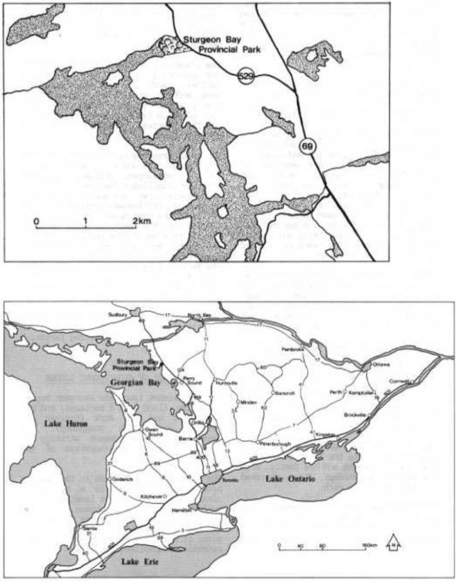
Enlarge figure 1 regional context map
Figure 2: Existing development
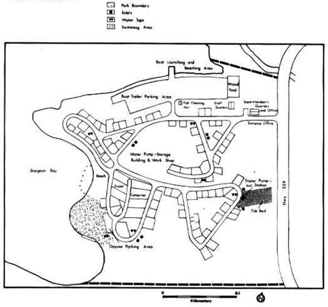
Enlarge figure 2: Existing development
With the fairly long average length of stay of 3.9 days - spring and fall use inclusive, a better grade of washroom facilities and electrical services to some campsites are appropriate. Vault privies are now the dominant facility.
The Park is bounded on the north and the south by small Massasauga rattlesnake habitats, Because of this situation Massasauga rattlesnakes have been sighted in the campground area. At present these snakes are captured and released in suitable habitat outside the Park boundaries, terminating further ingression.
3.0 Classification
Because of it’s size and the fact that two-thirds of its land base is developed, Sturgeon Bay Provincial Park is and will continue to be classified as a Recreation Park. Recreation Parks are areas, which support a wide variety of outdoor recreation opportunities for large numbers of people in attractive surroundings.
4.0 Goal
The Park goal will be to continue to provide facility-based camping and access to Georgian Bay for fishing and boating and also maintain or improve the Park’s present physical and natural qualities.
5.0 Objectives
Sturgeon Bay Provincial Park contributes to the achievement of the protection, recreation, heritage appreciation and tourism objectives of the Provincial Park system.
5.1 Protection objective
To protect a system of provincially significant natural environments incorporating natural, cultural and recreational features.
Through the use of zoning and special management guidelines, areas containing provincially, regionally and locally significant life and earth science features will be protected within Sturgeon Bay.
5.2 Recreation objective
To provide day use opportunities in areas of outstanding recreational potential.
To provide facility- based camping opportunities in areas of outstanding recreational potential.
Sturgeon Bay Park will continue to provide campers with boat access to the outstanding recreational potential of Georgian Bay for fishing, boating and related activities. The Park will also offer camping and limited day use picnicking opportunities on a seasonal basis within the size limitations of the Park.
The Park’s existing recreation opportunities contribute to the achievement of the recreation target as presented in the Parry Sound District Land Use Guidelines - 3,000 swimming, 2,000 picnicking and 18,000 camping opportunities.
5.3 Heritage appreciation
To provide opportunities in Sturgeon Bay for exploration and appreciation of natural and cultural environments and a visitor services program based upon the character and signifi- cance of Recreation Parks.
In Sturgeon Bay Park, the information segment of the visitor services program will be developed to reflect natural features and cultural features of the Park and surrounding area (Georgian Bay- Pointe au Baril). This program will also include protected areas within the Park that contain significant features that are on a provincial, regional and local scale.
5.4 Tourism objective
To provide Ontario residents and out-of-Province visitors with opportunities to discover and experience the distinctive regions of the Province.
Sturgeon Bay Park will provide camping opportunities and limited day use opportunities for travelers through Ontario as well as destination camping opportunities for those attracted from considerable distances desiring access to Georgian Bay for boating and fishing.
Sturgeon Bay’s existence in the tourism industry generates $440,420 worth of expenditures and supports 8 jobs in Ontario’s economy.
6.0 Zoning
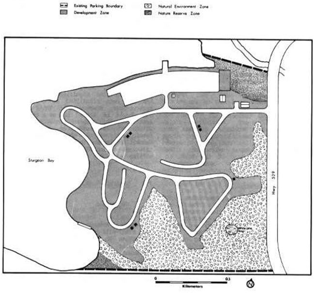
Sturgeon Bay Provincial Park has been divided into the following three zones (Figure 3): development, nature reserve, and natural environment. Due to the small size of the Park, no differentiation is made between development and access zoning.
6.1 Development zone (4.8 ha)
At least 65 percent of the Park’s eight hectares of land base has been developed. This zone contains 82 campsites, the entrance road and entrance office, sanitary and water facilities, day use and beach area, parking lots, boat launching and boat beaching area, woodlot, trailer dumping station, pumphouse and workshop building, a fish cleaning hut, as well as a centralized garbage drop-off point.
6.2 Nature reserve zones (1.2 ha)
Two areas in the Park are designated as nature reserve zones: one in the northeast corner and another in the southwest corner. Both areas are provincially significant wetlands. They have been zoned to protect Massasauga rattlesnake habitat for interpretation and scientific study.
The Massasauga rattlesnake is considered a potential endangered species. These areas are of high interpretive value. Interpretation should be conducted from the perimeter of both areas for safety reasons and to avoid possible damage to the habitat.
6.3 Natural environment zone (2.0 ha)
Approximately 25 percent of the Park area is zoned Natural Environment. This zone includes an aesthetic natural landscape and provides a buffer area for one of the two nature from the development zone.
A white pine bog (Figure 3) exists in the southern portion of the Park. This is the only area of this nature in the Park and has some interpretive value. It is a prominent area of approximately 17 square metres. But, because of its size and only having local significance the bog has not been classified as a Nature Reserve Zone. However, this white pine bog should be looked upon as a special area within this zone and protected as if it was a Nature Reserve Zone. The only development within the rest of the Natural Environment Zone will be limited to simple manmade facilities such as walking trails.
7.0 Resource management
7.1 Vegetation
A Vegetation Management Plan is required. The Plan will be introduced to identify techniques to maintain or create a particular quality of vegetation for different areas within the Park. Zones with vegetation progressing through natural succession will have different management techniques f ran zones where vegetation is maintained at its present stage of natural succession.
Reforestation will be carried out in the development zone to create buffer areas between campsites and to rehabilitate areas devoid of natural regenerative growth. An extensive forest rehabilitation program will be carried out in the trailer campsite area to alter the forest cover to a more desirable species composition.
Vegetation cover in the beach day use and play areas of the Park will be maintained in a park- like setting with a varying aged overstory and replacement trees in a sparse understory.
Figure 3: Zoning
All the areas designated under Nature Reserve Zone will be allowed to progress through natural succession.
The Natural Environment Zone will have a silvicultural program to promote growth of healthy, aesthetically pleasing forest cover similar to that now present except in the white pine bog area where it will be allowed to progress through natural succession.
Campsites will be rehabilitated to improve and maintain campsite quality for the long term. This includes the establishment of sight buffers comprised of shade tolerant vegetation species, which will discourage campers from walking through them.
Sand has been traditionally dumped and graded on campsites. This practice does not provide good soil to promote vegetation buffers between campsites or lesson soil erosion. Other, more appropriate methods will be applied to alleviate this problem.
7.2 Wildlife
No hunting will be allowed.
Trapping for nuisance beaver only will be permitted if necessary.
Present management practices of removing Massasauga rattlesnakes from campground areas and released in suitable habitat outside the Park seems to be working well and should be continued. Information on the subject will be made available to park visitors to discourage campers from harming or killing emigrating snakes.
7.3 Fire
Normal fire detection and suppression will be carried out to protect park resources.
7.4 Insects and disease
Measures for insect and disease control will be permitted, when necessary, throughout the Park for aesthetic purposes or if hazardous to park visitor health. Nature reserve zones will be included because of difficulty in separating them from overall treatment.
7.5 Resource extraction
No commercial extraction of Park resources will be permitted.
7.6 Fisheries
No fisheries management programs are carried out in the Park. There is, however, a program managing the fish population of Georgian Bay, which indirectly affects the visitors of the Park. Rehabilitation of the Bay’s fish communities will result in an increase in the volume of more desirable fish species. With a wisely managed and rehabilitated resource, sport fishing opportunities will increase.
7.7 Water quality
Water quality will be monitored by the Park’s present water quality sampling program. Any unnatural interference with Sturgeon Bay on which the Park depends for its water supply, will be investigated by this Ministry and the Ministry of Environment. Appropriate action will be taken under the Lakes and Rivers Improvement Act or the Public Lands Act to ensure that no pollutants or other debris enter the waters of Sturgeon Bay.
8.0 Client services
8.1 Public information
Information on the natural resources of the Park and surrounding area will be available in the Park’s small reference library through printed matter. Cultural and recreation resource information, as well as Park programs and facilities will be provided in the Park brochure, displays, and by informed park staff as well.
8.2 Interpretation
Park interpretation will be limited to self-use activities. Special programs during the summer season may be presented by the interpretive staff from Grundy Provincial Park or the district office if funding and staff are available.
8.3 Recreation
The most popular activities of the Park and surrounding area are fishing, boating and swimming. Due to the lack of available open space, recreation facilities are nonexistent. Adults with young children account for a major proportion of campers (56.2 percent) in Sturgeon Bay Park. For this reason, combined with the Park’s small size and limited visitor services, self-use recreation facilities such as horseshoe pits and creative playgrounds would be a definite asset.
8.4 Marketing
Sturgeon Bay Park operates at a high occupancy rate. The average stay is lengthy (3.9 days), indicating that Sturgeon Bay is more than just a stopover Park. Statistics indicate the Park is popular with senior citizens compared to the regional total. A greater percentage of visitors to the Park are from United States compared to the rest of the parks in the region. The traditionally good fishing is in all probability the reason.
The Park has excellent potential during the months of May, June and September for increasing camper use. The addition of a small comfort station with showers, the replacement of vault privies with flushing toilets, the restructuring of campsites and the enhancement of day use facilities would lengthen the stay of many visitors.
Advertising and public relations initiatives with these changes in design would be made to attract and accommodate campers and day users beyond the peak months of July and August.
A marketing plan to attract more visitors to Sturgeon Bay throughout its operating and shoulder seasons will be prepared with the following objectives: to hold present clientele; to attract campers in the shoulder seasons (spring and fall); to increase involvement with the commercial sector by encouraging park users to use and take advantage of local tourist services and attractions, and generally stimulate interaction between the Park and the private tourist and commercial sector in the vicinity.
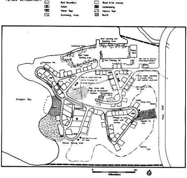
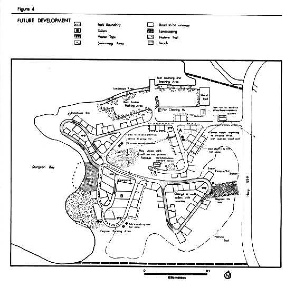
9.0 Development
The future development strategy for Sturgeon Bay Provincial Park will be to keep the Park as is with minor modifications to facilities and services. These alterations will improve the qualities of both the physical environment and visitor’s stay in Sturgeon Bay Park.
9.1 New roof on entrance office/superintendent’s quarters
due to deterioration problems a new sloped roof is required with sufficient pitch to shed snow easily as well as proper insulation and ventilation.
9.2 Power supply upgrading
To adequately service existing and proposed park facilities including the entrance off ice/ Superintendent’s quarters; staff quarters, wood yard; service to 30 campsites; water system and pumphouse; proposed shower/ workshop building; vault toilets (Figure 4). Power supply upgrading will be phased over a few years by reason of limited capital funding received annually in revenue retention from the operating concession.
9.3 Electrical service to 30 campsites
Maximum phased over a few years, starting with site 'A' (Figure 4).
9.4 Water system and pumphouse
To service the shower/workshop building and existing sanitary services in the Park. A new building will be located near campsite 12 on the northwest portion of the campground (Figure 4). The building will house two pumps, storage and pressure tanks, and water purification of a proper size to adequately service the Park. The upgrading, size and site location of the water system and pumphouse must be considered prior to the installation of the proposed shower/workshop comfort station, in satisfying the Park’s water demands.
Figure 4: Future development
Enlarge figure 4: Future development
9.5 Small shower building/workshop
A small central comfort station (size to be determined) with two showers and one toilet per side, combined with a small workshop space. It will be situated in the central portion of the campground (Figure 4). Campsites 32 and 33 will be reviewed to accommodate this building.
9.6 Upgraded tile field
The tile field will be upgraded to properly service the proposed shower/workshop building as well as the existing sanitary services.
9.7 Electrical service to vaulttoilets andwood yard
To provide lighting and appliance outlets and possibly hot water, taking a potential load off the comfort station and tile bed.
9.8 Recreation facilities andchildren'screative playground
A creative playground will be constructed of natural materials such as wood, logs and hemp rope. The play area will be designed in a linked configuration containing a series of climbing devices, balance beam, obstacles, unconventional swings and slides, which will activate the communicative, emotional and physical attributes of a child. Recreational facilities such as a horseshoe pitch will also be located here. It will be situated directly across from the day use area on the present pumphouse and workshop site.
10.0 Implementation strategy
Below is a list of development and redevelopment projects identified in the Development Section. This list is in chronological order according to priority. The number of projects to be completed or partially completed will be based on each year’s development funding.
| Priority Rating | Project Description |
|---|---|
| 1 | New roof on entrance office/superintendent' s quarters. |
| 2 | Power supply upgrading. |
| 3 | Electrical service to 30 campsites. |
| 4 | Vegetation Management Plan |
| 5 | Market Management Plan |
| 6 | Upgraded water system and pumphouse |
| 7 | Small workshop/comfort station with showers. |
| 8 | Upgraded tile field. |
| 9 | Electrical service to vault toilets and wood yard. |
| 10 | Landscaping and planting. |
| 11 | Creative playground. |
11.0 Public consultation
A preliminary management plan was written and made available by park visitors, adjacent landowners and local township offices to be reviewed and commented on. Very few comments were received. Most are in agreement of what was being proposed.
12.0 References
Ontario Ministry of Natural Resources. Earthand Life Science Reports for Sturgeon Bay Provincial Park. Parks Planning Section, Toronto, 1977.
Ontario Ministry of Natural Resources. Economic Impact of Provincial Parks in Ontario:A Summary Report Parks Planning Section, 1982
Ontario Ministry of Natural Resources. Ontario Provincial Parks Policy, Queen’s Park, June 1978.
Ontario Ministry of Natural Resources. Parry Sound District Land Use Guidelines, Regional Lands Office, 1983
Ontario Ministry of Natural Resources. Provincial Park Camper Survey, Summary Statistical Report, Parks Planning Section, 1979.
Ontario Ministry of Natural Resources. Provincial Park Statistics. Parks Planning Section, 1974-1984.