Towards a Greater Golden Horseshoe Transportation Plan: discussion paper
Read the discussion paper on the Greater Golden Horseshoe Transportation Plan.
Minister’s message
Caroline Mulroney,
Minister of Transportation
Our government is committed to addressing the unique transportation needs of every region across the province. Following the release of our transportation plans for the Southwestern and Northern regions of the province, I’m excited to share this discussion paper that outlines the initiatives and concepts to achieve our collective vision for improved mobility throughout the Greater Golden Horseshoe (GGH).
We have a vision is of an interconnected transportation system that provides a safe, seamless and accessible transportation experience for all Ontarians. And most importantly, a system that works better for you and the nearly 15 million people who will call the GGH home by 2051.
Our regional transportation network needs to be ready to meet the demands that will come with the forecasted population and employment growth. Our government understands that we need a transportation plan that will help us build a better system to keep goods and people moving for decades to come.
This paper outlines initiatives and concepts to meet our collective goals and the transportation challenges of the future and sets out priority near-term actions as a foundation to achieve this vision.
Although the GGH is an integrated economic region, its communities are diverse with different transportation needs. This paper considers many new challenges including economic transitions, new technologies and shifting demographics that will alter the way people use the transportation system.
The technical work and engagement accomplished over the past several years has helped us build a foundation for a long-term GGH Transportation Plan – a clear path forward that takes us to 2051 to meet the regions’ unique transportation needs.
We know our vision for the Greater Golden Horseshoe will not be complete without the continued valuable input of local municipalities, businesses, Indigenous communities and the general public. That is why we are inviting everyone to share their feedback with us on the proposed near-term commitments, immediate actions and conceptual ideas for the future outlined in the discussion paper.
Over the next few months, we will carefully consider and incorporate feedback as we work towards releasing the GGH Transportation Plan later in 2021.
I look forward to hearing what you have to say. Together, we’re helping to shape a better and unified transportation network for our province's future.
Introduction
The Greater Golden Horseshoe (GGH) is a large urban region centred around Toronto, encompassing Waterloo, Brant and Haldimand in the west, Niagara to the south, Simcoe in the north, and Peterborough and Northumberland in the east. (Figure 1) It is home to 10 million people, or over 60% of Ontario’s population.
The GGH is the economic engine of the province. Two-thirds of Ontario’s gross domestic product (GDP) is generated here.
A well-functioning transportation system is critical to economic prosperity. Time waiting for a bus, time stuck in traffic on the way to meet a client or to make a delivery – all of these are costs to our economy.
Infrastructure investments haven’t kept up and won’t meet future needs on their own. Over the 15-year period of 2001-2016, travel demand on the highways grew three times faster than the rate of new road construction during this time.
This trend will result in more gridlock unless we have a comprehensive and long-term plan. A range of solutions are needed, including increasing infrastructure capacity, using our infrastructure wisely, and providing options for people and businesses to choose the most effective way to get around.
Mobility in the GGH is provided by a complex system of provincial, municipal and private sector infrastructure, services and programs. There is a need for a common vision for the region, so that all the investments we are making work together.
Over the past several years, the Ministry of Transportation has been engaging with its partners and analysing options, to develop a long-term vision for mobility in the GGH to 2051, and to set out a path to achieve our shared goals for the transportation system.
We look forward to your continued input!
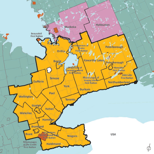
Figure 1: Greater Golden Horseshoe Study Area
Map of the Greater Golden Horseshoe relative to the rest of Southern Ontario.
Legend: Administrative Boundaries: Lower Tier Municipal Boundaries Upper/Single Tier Municipal Boundaries; Greater Golden Horseshoe Boundary
Purpose of this discussion paper
This discussion paper is being released in order to seek your feedback to inform the development of a long-term transportation plan for the Greater Golden Horseshoe.This paper sets out the proposed 2051 vision for mobility in the region, which has been designed to meet our collective goals and the transportation challenges of the future.
Just as important, it sets out actions we’re already taking or plan to take in the near-term, to set us on a path to achieve this vision.
The remainder of Section 1, the Introduction, describes the transportation challenges and the work the
Ministry of Transportation has done to date to develop a GGH Transportation Plan.
Section 2, the 2051 Vision for Mobility, describes the proposed future transportation system and what’s needed to achieve our vision of an integrated transportation system that provides a safe, seamless and accessible transportation experience for all. It graphically illustrates a proposed approach to new and improved infrastructure, and outlines services and policies to bolster that network.
Section 3, Near-Term Actions, sets out work that is currently underway or planned in the region – infrastructure, services and policies – that is making measurable improvements to transportation experiences now, to realize our long-term vision.
Section 4, Next Steps, discusses next steps and seeks your input on implementation considerations for the future.
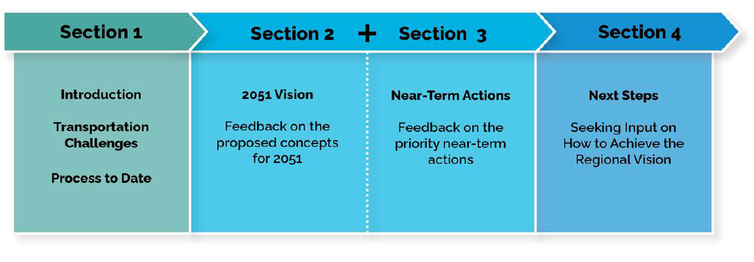
Section 1: Introduction; Transportation challenges; Process to date
Section 2 + Section 3: 2051 vision; Feedback on the proposed concepts for 2051; Near-term actions; Feedback on the priority near-term actions
Section 4: Next steps; Seeking input on how to achieve the regional vision
The transportation challenge
Getting ahead of rapid growth
The Greater Golden Horseshoe is a dynamic and rapidly growing region. It is a nationally significant hub for goods movement and business travel that sees $1.16 trillion in goods transported annually on its highways. It is a critical gateway for trade and tourism.
The GGH population is forecasted to grow from 10 million people in 2019, to 14.9 million people by 2051. This rapid growth, alongside technological and socio-economic changes, will create an increasingly complex and congested transportation network over the coming decades.
Congestion is already costing the economy up to $11 billion a year in productivity in the Greater Toronto and Hamilton Area and will get worse if current trends continue. Total hours lost in congestion would be more than tripled by 2051 if we don’t address this challenge.
The vast majority of trips in the region – by car, bus, truck, or bicycle – take place on a road, and this will continue into the future. However, roads alone cannot keep up with growth. From 2001 to 2016, travel demand on provincial highways in the GGH grew three times faster than the rate of new road construction during this time. We need to provide more choices on how and when people and goods travel and offer creative solutions to make the most of our infrastructure.
Although the GGH is an integrated economic region, its communities are diverse, with different transportation needs. The highly urban core of the City of Toronto will rely on transit and active transportation to move masses of people. The rapidly growing suburban municipalities surrounding Toronto require more transportation options and better connections. Small towns, rural areas and Indigenous communities need right-sized options to access services.
In planning the transportation system for the next 30 years, we have to consider many new challenges including economic transitions, new technologies such as automated and connected vehicles, and shifting demographics that will alter the way people use the transportation system. Some of these changes have the potential to fundamentally disrupt the transportation industry.
People and jobs in the Greater Golden Horseshoe
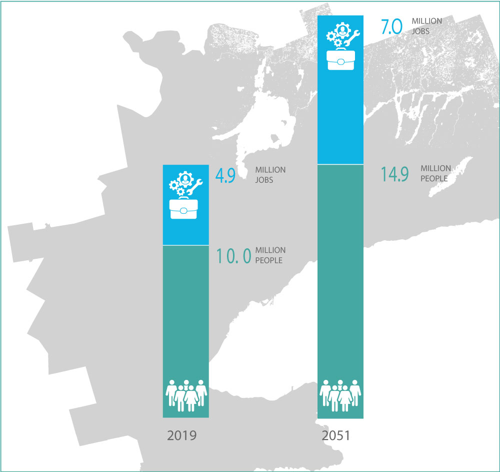
People and jobs in the Greater Golden Horseshoe (Amendment 1 (2020) to the Growth Plan for the Greater Golden Horseshoe 2019)
Graphic illustrating increase in people and jobs in the Greater Golden Horseshoe between 2019 (4.9 million jobs; 10.0 million people) and 2051 (7.0 million jobs; 14.9 million people).
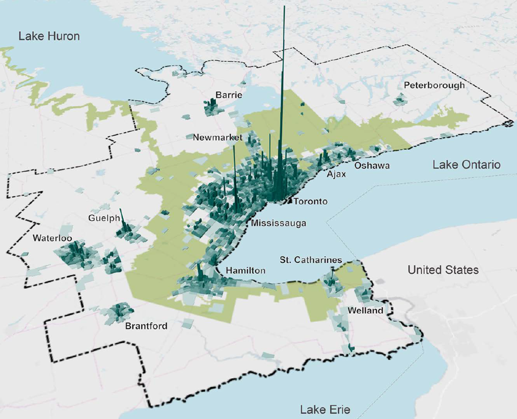
Figure 2: Forecast concentration of people and jobs per hectare across the GGH in 2051
The GGH in 2051 will encompass diverse communities with different built forms and different transportation needs. Figure 2 shows the forecasted number of people and jobs per hectare in 2051.
Process to date
Developing the GGH transportation plan
The process to date to develop a long-term vision of the transportation system has been comprehensive and innovative. The Ministry of Transportation has worked with partners – municipalities, Indigenous communities and organizations, transit agencies, community and business stakeholders and the public – to look at both long-term planning and shorter-term gap analysis. Robust measures were developed based on public input on goals and objectives, and these measures were used to evaluate solutions.
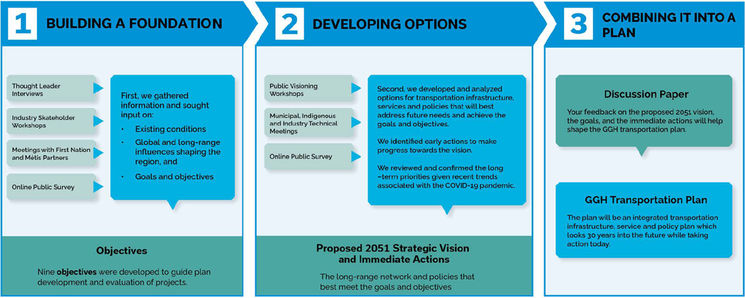
Diagram: The process to develop a long-term vision of the transportation system
1. Building a foundation
First, we gathered information and sought input on:
- Existing conditions
- Global and long-range influences shaping the region, and
- Goals and objectives
- Thought leader interviews; industry stakeholder workshops;
- Meetings with First Nation and Métis Partners; online public survey
- Objectives
- Nine objectives were developed to guide plan development and evaluation of projects.
2. Developing options
Second, we developed and analyzed options for transportation infrastructure,services and policies that will best address future needs and achieve the goals and objectives
- We identified early actions to make progress towards the vision.
- We reviewed and confirmed the long-term priorities given recent trends
associated with the COVID‑19 pandemic.
Public visioning workshops; industry stakeholder workshops; municipal, Indigenous and industry technical meetings; online public survey - Proposed 2051 strategic vision and immediate actions
- The long-range network and policies that best meet the goals and objectives
3. Combining it into a plan
- Discussion Paper
Your feedback on the proposed 2051 vision, the goals, and the immediate actions will help shape the GGH transportation plan. - GGH Transportation Plan
The plan will be an integrated transportation infrastructure, service and policy plan which looks 30 years into the future while taking action today.
A vision for mobility in 2051
The proposed Greater Golden Horseshoe Transportation Plan would set out a 30-year vision for mobility in the region to guide and align decisions and investments. It will focus on the transportation system at a regional scale and solutions that will have a region-wide impact. This recognizes that additional solutions may be planned at a local level as well as beyond 2051.
Our proposed vision is of an interconnected transportation system that provides a safe, seamless and accessible transportation experience for all.
This is a vision of a transportation system that works better for you. Transit will be there when you need it to get to your early shift, not just during rush hour. A network of freight routes will get your goods to the warehouse on time. One easy-to-understand fare will get you from the beginning to the end of your trip.
To get there, we need a mix of solutions.
We need new infrastructure – more and better-connected transit and walking and cycling paths, and improved road capacity in the most congested areas.
We need better services – including more frequent and convenient buses, trains, and on-demand shared vehicles.
We need new policies – including policies that improve the transportation experience by creating seamless transit options, encourage new ways of getting around, harness technology and enable new transportation choices.
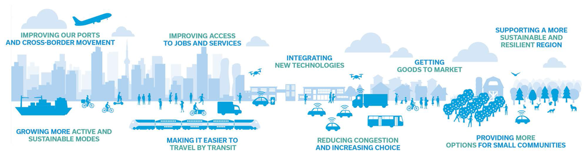
Transect of the GGH region, illustrating vision as it relates to a diverse range of various users and geographies in the region: Improving our ports and cross-border movement; Growing more active and sustainable modes; Improving access to jobs and services; Making it easier to travel by transit; Integrating new technologies; Reducing congestion and increasing choice; Getting goods to market; Providing more options for small communities; Supporting a more sustainable and resilient region
Getting people moving on a connected transit system
The first pillar of the proposed 2051 vision is the transformation of the regional transit system from today’s radial commuter network with most connections centered on Union Station, to an expansive grid, so you can get where you need to go without going through the core. With new routes, more frequent services and more connections, you will be able to quickly and easily travel across the region.
This pillar of the 2051 vision would be achieved with a mix of new infrastructure, services, and policies, illustrated in Map 1 and detailed below:
- Delivering major transit investments that are at various stages of planning, design and construction including the Ontario Line, Eglinton Crosstown West Extension, Yonge North and Scarborough Subway Extensions and Finch West, Hurontario and Hamilton LRTs.
- Exploring a new east-west, cross-regional connection between Burlington and Oshawa that connects existing GO Rail lines outside of Union Station.
- Exploring a new transit loop that connects the Ontario Line to new major transit hubs where regional services connect, including at Pearson Airport and Richmond Hill Centre.
- Increasing the frequency of local transit service to every 10 minutes, across all urban areas.
- Fully integrating transit fares and services to provide seamless connections across the region.
- Ensuring 24-hour public transportation access to better serve employees of the region’s largest employment nodes.
- Planning services to support equity of access and mobility for marginalized people and communities.
- Promoting walking and cycling as a first choice for short trips and to access transit stations by connecting active transportation routes to establish a safe and convenient network.
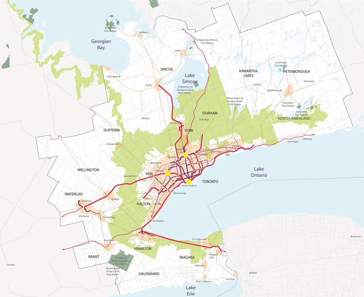
Map 1: The Greater Golden Horseshoe illustrating current, planned and conceptual future transit infrastructure and services.
Legend:
Rail and regional transit: Existing / committed GO Transit Line; via Rail connection; Existing and new regional bus connections (public, private and/or on-demand services)
Transit: Existing subway / higher order transit; Committed subway / higher order transit connection; Conceptual / new higher order transit connection
Additional features: Greenbelt; First Nation Reserve; GGH Boundary (The GGH study boundaries include parts of MNO regions 7, 8, and 9); Areas with frequent local transit service (for example, with 10-minute minimum headway); Conceptual transit hub / transfer
Enhancing capacity and performance on congested roads
The second pillar of the proposed 2051 vision is a resilient road network that provides more capacity in the most congested areas, more efficient freight routes and better route alternatives. Policies will encourage road users to shift their travel so the system works better for everyone; for example taking trips earlier or later in the day or taking other modes of transportation. A stronger road network means you will be able to get where you want to go reliably and on time
This pillar of the 2051 vision would be achieved with a mix of new infrastructure, services, and policies, illustrated in Map 2 and detailed below:
- Delivering major highway projects at various stages of planning and design including the GTA West corridor, Bradford Bypass, and twinning the Garden City Skyway, all of which will create a more resilient network.
- Expanding highways at strategic locations across the region to relieve congestion, including the Highway 401 central section and connections to the outer ring on Highways 400, 401, 403, and the QEW.
- Establishing a network of connected managed lanes on the region’s highways, to maximize capacity and prioritize uses such as transit and goods movement.
- Exploring options to manage passenger travel demand and congestion, particularly during peak hours, by using strategies to shift travel flows (such as pricing, parking charges, telecommuting and flexible work hours).
- Supporting innovation and leveraging new technologies, such as automated, connected and electric vehicles, that achieve a safer, more efficient, equitable and sustainable transportation system.
- Planning, designing and managing the road network and rights-of-way to support safety and mobility for all users, regardless of age, ability or mode of travel.
Map 2: Current, planned and conceptual future road infrastructure
Legend:
Highway Network: Existing Highway; Existing Arterials; Committed Widening; New Capacity Expansion; New Planned and Conceptual Corridors; Existing and Future Managed Lane (Managed Lane may include HOV lane, HOT lane, Express Toll lane, Bus-only lane and Truck-only lane).
Additional features: Greenbelt; First Nation Reserve; GGH Boundary (The GGH study boundaries include parts of MNO regions 7, 8, and 9); Areas with frequent local transit service (for example, with 10-minute minimum headway); Conceptual transit hub / transfer
Efficiently moving goods across the region
The third pillar of the proposed 2051 vision is an integrated, multimodal Strategic Goods Movement Network. By identifying this network as a priority for movement of freight, we will be able to better protect these key facilities and connections to make sure that people can get the goods they need, and businesses can thrive as the region continues to grow.
This pillar of the 2051 vision would be achieved with a mix of new infrastructure, services, and policies, illustrated in Map 3 and detailed below:
- Planning for and managing the movement of freight on the key routes, corridors and rail, air and marine facilities identified in the Strategic Goods Movement Network so that the region is economically competitive.
- Connected corridors with real-time traffic management and new technologies such as cooperative truck-platooning, which is when two or more vehicles are driven together as a group using vehicle-to-vehicle communications and driving support systems.
- Network performance monitoring on an ongoing basis to identify future needs and improvements across modes to better serve goods movement.
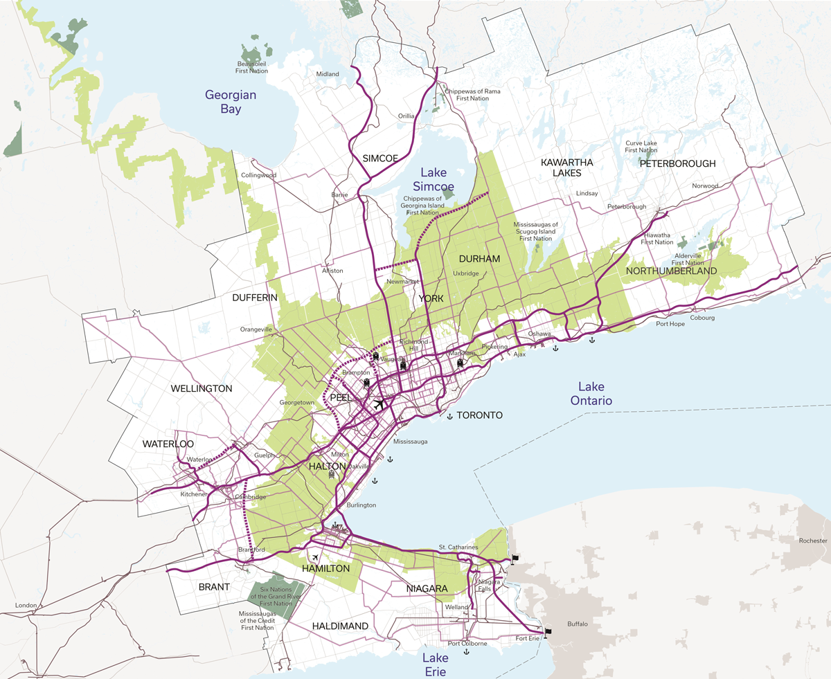
Map 3: Current, planned and future conceptual Strategic Goods Movement Network elements
Map of the GGH illustrating current, planned and conceptual future Strategic Goods Movement Network elements
Legend
Network Elements: Existing and future 400 series and controlled access highways; Other highways and arterials; Railroad; Airport; Train yard; Future train yard; Port; Border crossing
Additional features: Greenbelt; First Nation Reserve; GGH Boundary (The GGH study boundaries include parts of MNO regions 7, 8, and 9); Areas with frequent local transit service (for example, with 10-minute minimum headway); Conceptual transit hub / transfer
Near-term actions
The previous section outlined a proposed long-term vision of an interconnected transportation system that provides a safe, seamless and accessible transportation experience for all. Progress is already being made towards this vision, with many actions underway.
Achieving our long-term vision to improve mobility for all requires us to take action now.
We have identified 7 interconnected near-term goals where we can make meaningful improvements – to infrastructure, services and policies – that will help us move towards achieving the vision for 2051.
The following actions listed under each goal are a selection of the types of actions that will be included in the GGH Transportation Plan. These actions are intended to support people, Indigenous communities and businesses in optimizing the existing transportation system while actively working to create a better transportation network today and for future generations.
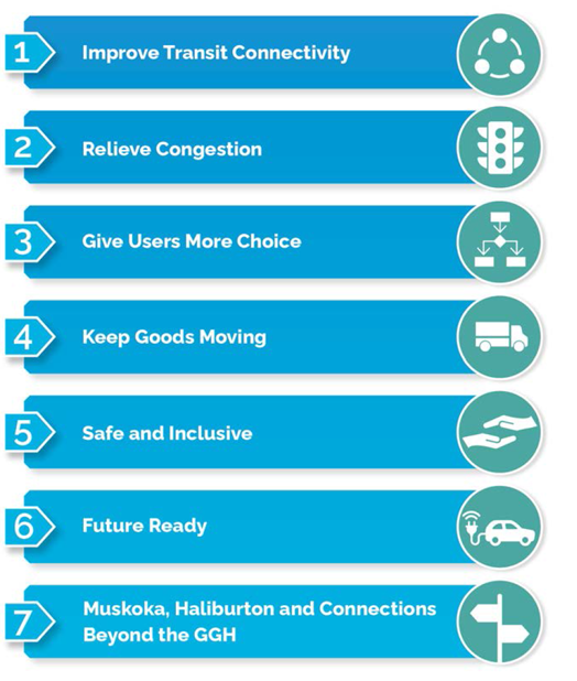
7 interconnected near-term goals
- Improve transit connectivity
- Relieve congestion
- Give users more choice
- Keep goods moving
- Safe and inclusive
- Future ready
- Muskoka, Haliburton and connections beyond the GGH
Improve transit connectivity
We are taking action now to make transit a more viable travel option for people throughout the region. Working closely with Metrolinx, an agency of the Government of Ontario, we are building an efficient, accessible, and reliable regional transit network in the GGH.
While the COVID‑19 pandemic has had a significant impact on our transit systems, it is more important than ever to take a long-term view to building out and improving the transit network for the future.
We are working today to better connect transit, taking action in three key areas that you told us were important:
Sample actions planned & underway
- To enhance and expand transit service connectivity, we are:
- Building new transit routes and stations in highly urban areas to ensure people can get to where they live and work more quickly. Ontario is undertaking the largest transit expansion in Canadian history, with the Ontario Line, Eglinton Crosstown West Extension, Yonge North and Scarborough Subway Extensions, and Finch West, Hurontario and Hamilton Light Rail Transit.
- Working to provide two-way, all-day service every 15 minutes over core segments of the GO Transit rail network including the Barrie, Lakeshore, Stouffville and Kitchener lines.
- Implementing high quality transit hubs that bring together local buses and rapid transit lines as part of investments to the GO Transit rail network, LRTs and subways.
- Starting to plan for a future Phase 2 of Ontario’s GTA transit plan, including the Sheppard East subway extension, Eglinton Crosstown extension to Pearson Airport, and exploring the Ontario line loop concept.
- To improve the transit user experience with a more integrated region-wide transit network, we are:
- Working with Metrolinx and local transit agencies to improve service integration and streamline fare structures in the region.
- Establishing a Fare and Service Integration Provincial - Municipal Table. The Table will support COVID‑19 recovery by providing recommendations to the Province on ways to improve transit and the rider experience in essential areas such as accessibility, equity, mobility and access to key destinations including employment, health, social services and educational hubs.
- Exploring opportunities to provide more complete, accurate and accessible scheduling and wayfinding information to transit and passenger transportation users to support convenient and seamless travel across modes, service providers and boundaries, including through expanded access to open data and data exchange initiatives to facilitate customizable trip planning.
- To improve access to the transit system by active transportation, we are:
- Making it easier to walk or cycle to or from transit stations by working with municipalities to prioritize and coordinate improvements to active transportation facilities, such as bike lanes, that connect to transit stations and stops.
- Developing a best practices guideline document to support updates to the e-bikes framework, in addition to guidelines for cargo e-bikes and e-scooters previously released. The framework will create 3 distinct classes (bicycle style, moped style and motorcycle style) to help municipalities choose which classes of vehicles to safely integrate on their transportation infrastructure and make active transportation a safer and more convenient alternative for shorter trips.
Relieve congestion
Mounting road congestion is a significant drain on the region’s economy, costing up to an estimated $11 billion per year in the Greater Toronto and Hamilton Area alone. While targeted highway expansions and improvements are part of the solution, we cannot simply build our way out of congestion. Relieving congestion also requires improving the capacity of corridors through managed lanes, shifting trips to other modes where possible, and reducing demand overall.
We are working today to improve the efficiency of our existing transportation system, taking action in the following key areas:
- Optimize Existing Corridors
- Provide Route Alternatives
- Provide Alternative Ways to Travel
- Reduce the Need for Travel
- To optimize existing transportation corridors, we are:
- Expanding our highways and continuing to build out the managed lanes network, including widenings on Highway 400 from Langstaff Road to Highway 9 in York Region, and Highway 401 between Milton and Mississauga.
- Implementing bus bypass lanes on Highways 8 and 401, working with the Region of Waterloo, to provide more efficient local and regional bus services between Kitchener and Cambridge during periods of high congestion. The bypass lanes benefit local transit, GO buses, and private carriers.
- To provide more and faster route alternatives, we are:
- Completing route planning, preliminary design and environmental assessment work for the GTA West Highway and Transit Corridor, which will provide new connections and options, and redundancy in case of highway closures, between York, Peel and Halton Regions for both passengers and goods.
- Advancing engineering and environmental assessment work for the Bradford Bypass, a new four‐lane controlled access freeway that will connect two busy Ontario highways – Highway 400 and Highway 404 – in Simcoe County and the Region of York.
- To support alternative travel choices we are making it easier to find housing or jobs near transit:
- Developing transit-oriented communities (TOCs) at transit stations in strategic locations to provide more options for people to live and work near transit, increase housing supply, including affordable housing, increase transit ridership and reduce traffic congestion.
- To reduce the need for travel, we are:
- Continuing recent progress made during the COVID‑19 pandemic in e-service delivery. Through MTO’s Digital First program, the Ministry is enhancing the public and business experience for the most used services, such as moving from in-person channels to online, making services simpler, better, faster and more accessible.
Give users more choice
With more people walking and cycling than ever, the pandemic has highlighted the importance of providing safe travel options for everyone. We are working to improve access to and expand options, to make it easier to get around without a car, whether you are travelling a few blocks or across the region.
We are working today to give you more transportation choices, taking action in four key areas:
- Transit Availability
- Comprehensive Active Transportation Network
- Barriers to Transit Access
- Mobility as a Service
Sample actions planned & underway
- To improve access to and availability of transit services, we are:
- Supporting community transportation in areas of Ontario that are unserved or underserved by transit services through the Ontario Community Transportation Grant Program. Seven municipalities in the GGH are receiving up to $4.4 million over five years (2018-2023) to deliver local and intercommunity bus services.
- Opening up the intercommunity bus sector to improve transportation options, support economic recovery, and reduce red tape for business. As part of this initiative, the province is also enhancing the safety and insurance regime for bus carriers and developing safety requirements for inter-community passenger transportation vehicles with a capacity of up to nine passengers.
- To create a safe, connected and comprehensive active transportation network, we are:
- Improving local and regional cycling linkages by working with municipalities, Indigenous communities and agencies such as Metrolinx to connect existing and planned cycling routes, infrastructure and amenities with the Province-wide Cycling Network.
- To support the development and effective implementation of Mobility as a Service (MaaS), we are:
- Working with Metrolinx, presto and other partners to investigate opportunities for a MaaS solution in the GGH and beyond.
- To remove barriers to access within the transportation system, we are:
- Supporting accessibility improvements at regional transit facilities by convening accessible transit planning and design forums through Metrolinx, including an Accessibility Advisory Committee and an annual public regional accessibility consultation.
Metrolinx is also working with municipalities to develop standards that support customers with visible and invisible physical or mobility challenges by improving universal accessibility across the regional network and through a consistent application of Personal Assistance Intercom devices.
- Supporting accessibility improvements at regional transit facilities by convening accessible transit planning and design forums through Metrolinx, including an Accessibility Advisory Committee and an annual public regional accessibility consultation.
Keep goods moving
The efficient movement of goods and cargo across the GGH is critical to supporting recovery and keeping the economy moving. Billions of dollars worth of goods move across the region by road, air, marine, and rail every day.
We are working with our partners today to ensure improved efficiency and integration across modes, taking action in three key areas:
Sample actions planned & underway
- To support Ontario’s competitiveness and reduce red tape, we are:
- Streamlining inspection and administrative burdens on commercial vehicle operators to support the reduction of red tape and increasing efficiencies for businesses through digital transformation of our commercial carrier products.
- Improving the Ministry of Transportation's corridor control and permit process while maintaining safety and operational efficiency by working with municipalities to address red-tape and processing delays in the approval of development applications and permits, such as through municipal pre-consultation meetings.
- To coordinate freight planning and freight-supportive infrastructure across the region, we will:
- Work with municipalities to plan for and protect the capacity of the routes, corridors and facilities identified in the Strategic Goods Movement Network (SGMN) by integrating consideration of the SGMN into relevant municipal land use plans and transportation studies.
- To improve the sustainability and efficiency of the freight sector, we are:
- Working with partners to encourage the use of Off-Peak Delivery (OPD) in municipalities across Ontario.
- Exploring opportunities to support additional marine freight in the Great Lakes – St. Lawrence Seaway, in collaboration with the federal government and private sector partners.
Safe and inclusive
Ontario is a road safety leader in Canada and North America. By continuing to prioritize user safety and security we are building a transportation system that is safe and inclusive for everyone to use, including children, youth, seniors and people with disabilities.
We are working today to make our transportation system safer and more secure, taking action in three key areas:
Sample actions planned & underway
- To improve user safety and security in the transportation system, we are:
- Improving towing and storage industry safety and standards by enacting the Towing and Storage Safety and Enforcement Act as part of the Moving Ontarians More Safely Act. This Act will strengthen provincial oversight of the towing and storage sectors. The province is also establishing a tow zone pilot on designated sections of provincial highways and launching a Joint Forces Operation team to address violence in the towing industry, among other measures.
- Metrolinx, in partnership with municipalities, is developing and implementing enhanced safety measures for at-grade road crossings through the GO Expansion program.
- Combatting human trafficking through training to increase recognition and reporting, posting educational material with the Canadian Human Trafficking Hotline information and working with key partners to increase awareness of human trafficking. In addition, we are making transportation facilities such as rest areas safer through infrastructure upgrades such as site clearing, improved lighting and security cameras, where feasible.
- An Indigenous inclusion lens will be applied when developing actions and initiatives, in line with the Calls for Justice of the Final Report of the National Inquiry into Missing and Murdered Indigenous Women and Girls (MMIWG).
- To understand and manage potential future transportation system impacts and risks, we are:
- Developing and conducting coordinated emergency response plans and exercises to be prepared for a range of emergency situations, including extreme weather events, security and cybersecurity incidents, utility outages, pandemics and disease, among others.
- To mitigate and remove physical and systemic equity barriers to access within the transportation sys tem related to factors such as race and ethnicity, age, gender, income and persons with disabilities, we are:
- Developing a framework for transportation access and inclusion that will guide MTO in considering the experiences of underserved people or communities, such as racialized groups, inclusive of age, gender, income and persons with disabilities, in its transportation decisions.
- Establishing a new funding program to support Indigenous communities and organizations in pursuing transportation-related projects.
- Exploring and implementing opportunities to increase Indigenous people's access to critical services, such as healthcare, employment and education, as well as places of cultural significance. This includes eliminating barriers for Indigenous people when accessing transportation services, such as improving access to driver's licensing and personal identification services.
Future ready
This is an era of significant change. Climate change, economic restructuring, changing demographics, and new technologies like connected and automated vehicles (CV/AVs) and automation could fundamentally transform the way people live, work and move in the GGH.
To prepare for an uncertain future we are working to create a more resilient and environmentally sustainable transportation system, one that embraces innovation and technological change, adapts and responds to the potential risks associated with climate change, and protects the environment for future generations.
We are working today to prepare for the needs of the future, taking action in the following key areas:
Sample actions planned & underway
- To minimize the impact of the transportation system and users on the natural environment, we will:
- Reduce the impacts of transportation emissions on the environment by:
- Supporting the adoption of low- and zero-carbon modes, including active transportation and the adoption of electric and hydrogen-powered cars, trucks and transit vehicles
- Developing a strategy for low- and zero-carbon charging and fuelling stations
- Exploring technological and regulatory measures to reduce emissions in higher polluting vehicles such as the enhanced emissions testing and enforcement program for heavy diesel commercial motor vehicles.
- Raise awareness of the benefits and opportunities associated with low- and zero-carbon transportation options, working with non-governmental organizations and municipalities.
- Reduce the impacts of transportation emissions on the environment by:
- To build and manage the transportation system to be resilient in the face of climate change, we are:
- Utilizing the most up-to-date climate change project data and information to make informed decisions, including incorporating findings from Ontario’s first-ever multi-sector Climate Change Impact Assessment, to help the province, municipalities, Indigenous communities and local partners make informed decisions on planning and infrastructure investments.
- To leverage electric, connected and automated vehicle technologies and other emerging mobility technologies, we are:
- Becoming a North American hub for the next generation of electric vehicles. In October 2020, the government announced it is matching a $295 million investment with the federal government to retool the Ford Oakville Assembly Complex into a global hub for battery electric vehicle production. This $1.8 billion project represents one of the most significant investments in Ontario’s auto sector in a generation.
- Exploring the creation of an innovation corridor by leveraging provincial highway infrastructure to provide a real-world opportunity for businesses to test and/or pilot advanced and connected mobility technologies.
- Ensuring and encouraging the safety and innovation of CV/AV technology on our roads through Ontario’s AV Pilot Program. Ontario will be considering amendments to the AV Pilot Program, that will allow for further improvements to how Ontario monitors industry developments and evaluates the safety of AVs included in the pilot.
- Exploring opportunities to make it easier to get to and from GO stations using automated vehicle technologies. Metrolinx is supporting automated shuttle pilot programs, including with the Toronto Transit Commission at Rouge Hill GO and Durham Region Transit at Whitby GO station.
- Addressing challenges related to CV/AV adoption and readiness by connecting municipalities, transit agencies and other mobility service providers through the Ontario Smart Mobility Readiness Forum.
Muskoka, Haliburton and connections beyond the GGH
Ontario’s heritage, culture and tourism sectors are interconnected and contribute to a significant double bottom line – economic growth and supporting the cultural fabric of the province.
Ontario is the largest travel destination in Canada. With a number of municipal and international airports that drive economic opportunities, such as Toronto Pearson International Airport, as well as major international border crossings by road and rail, the GGH is a gateway for visitors and residents to access destinations across the province. Regional airports such as Niagara District, Peterborough, and Lake Simcoe, together with the international airports in Mississauga, Waterloo, Hamilton and Toronto create a robust network of airports that support business travel, tourism travel, and associated freight and deliveries, both within the GGH and beyond.
The GGH is also a major tourism destination in itself, with the City of Toronto, Niagara Falls, the Collingwood and Blue Mountains area, and the Peterborough-Kawartha Lakes region attracting millions of visitors each year.
The tourism industry, however, has been one of the hardest hit sectors and is expected to be one of the last to recover from the pandemic. With a view towards supporting post-pandemic recovery, we are working to improve linkages to support local, business and tourist travel.
Sample actions planned & underway
To improve connections beyond the GGH and support local, business and tourist travel, we are:
- Undertaking focused technical analysis in the District of Muskoka, the County of Haliburton and across eastern Ontario, which will consider local travel need, tourism travel needs, and improved connections to the GGH and the rest of Ontario.
- Establishing task forces made up of local leaders in each regional transportation planning area, to advise the Minister of Transportation on additional ways to improve connections between modes and communities and opportunities to better support tourism recovery from the impacts of the pandemic.
- The Southwestern Task Force has already been established and is discussing issues such as highway, airport, and transit improvements and opportunities that connect to the GGH, including along the Hwy 401 corridor as well as in the Blue Mountains and Owen Sound areas, among other topics.
- Advancing planning and design work for the re-introduction of passenger rail service connecting Toronto (Union Station) with Northeastern Ontario, as announced in the 2021 Budget.
- Conducting an airport activity and infrastructure survey to update data on the role of Ontario municipal airports in supporting economic development and public service delivery. This will help support future coordination and integration efforts with air network partners to optimize the movement of goods and people and align regional investments with these strategies.
- Reviewing at-grade intersections between Bracebridge and Huntsville on Highway 11 and identify improvements to make the highway safer for the travelling public.
- Advancing highway rehabilitation projects in the District of Muskoka and County of Haliburton, such as road resurfacing on Highway 11, bridge rehabilitation on Highway 400 and paving shoulders on Highway 118.
- Addressing traffic and safety concerns in the Georgian Bay area, including connections between the Greater Golden Horseshoe and southwestern Ontario, by working with municipalities to explore improvements along highways and county roads, such as the implementation of revised posted speed limits on Highway 26 in the Craigleith area, to better support tourism and local mobility.
Implementation & next steps
A plan for the whole region
The province has a leadership role in planning the transportation system, and has put out this Discussion Paper, to help articulate a long-range vision for a transportation system that meets the future needs of the Greater Golden Horseshoe.
However, the province is only one player – other levels of government, transportation agencies, industry, local businesses, Indigenous partners and other service providers all make investments and decisions that shape the transportation system.
By working together to achieve a shared vision, these investments can be aligned and can ensure we have the transportation system we want and need.
The successful implementation of the GGH Transportation Plan and achievement of the vision will require collaboration and new ways of working together, as well as new and innovative approaches to policy solutions and infrastructure delivery.
We are seeking your ideas for ways to achieve the vision, including:
- Collaboration, coordination and new ways of working together to align our actions
- New and innovative approaches to policy solutions and programs
- New ways to partner, procure and deliver infrastructure
Next steps
Ontario is committed to working with, and gathering input from, the federal government, municipalities, Indigenous communities and organizations, transportation agencies, industry, local businesses, and the public to achieve our shared goals and build a better transportation system for the GGH.
As the province develops the GGH Transportation Plan, some elements will be conceptual ideas for further exploration, and other will be near term commitments and immediate actions. We are seeking your input on both elements.
The technical work and engagement done over the past several years has helped us build a foundation for the GGH Transportation Plan as proposed in this Discussion Paper. Over the next few months, we will carefully consider and incorporate feedback as we work towards releasing the Plan later in 2021.
In addition to the questions posed in each section, please consider the overall questions:
- Are the goals and near-term priorities and actions the right areas of focus?
- What else should be done in the near-term?
- Are there implementation considerations as we develop the GGH Transportation Plan and turn the 2051 vision into reality?
We are seeking feedback before August 28, 2021.
We want your feedback!
Please provide your input on the proposed concepts for 2051, the priority near-term actions, and how to achieve the regional vision.
Visit direct link to consultation to provide your thoughts on this discussion paper.
Questions?
Reach out to us at GGHTransportationPlan@Ontario.ca